
1
BASIC ASSESSMENT SPECIALIST REPORT:
Desktop general ecological study on the potential impacts of the
proposed Mulilo Augrabies Solar PV Project near Augrabies,
Northern Cape
Prepared by
Dr David Hoare
(Ph.D., Pr.Sci.Nat.)
David Hoare Consulting cc
41 Soetdoring Ave
Lynnwood Manor,
Pretoria
for
Rosenthal Environmental (Pty) Ltd
Postnet 114,
P/Bag X18,
Rondebosch, 7701
on behalf of
Mulilo Renewable Energy Pty Ltd
2 April 2012
REPORT VERSION: Final
David Hoare Consulting cc Biodiversity Assessments, Vegetation Description / Mapping, Species Surveys

2
REGULATIONS GOVERNING THIS REPORT
This report has been prepared in terms the EIA Regulations promulgated under the National
Environmental Management Act No. 107 of 1998 (NEMA). A Basic Assessment study is
undertaken in accordance with Regulation 22 in terms of the EIA Regulations published in
Government Notice (GN) R543 of 18 June 2010, in terms of Chapter 5 of Section 24(5) of the
National Environmental Management Act (No. 107 of 1998).
Appointment of specialist
David Hoare of David Hoare Consulting cc was commissioned by Rosenthal Environmental to
provide specialist consulting services for the Basic Assessment for a proposed photovoltaic
solar energy facility near Augrabies in the Northern Cape Province. The consulting services
comprise an assessment of potential impacts on the fauna and general ecology in the study
area by the proposed project.
Details of specialist
Dr David Hoare
David Hoare Consulting cc
Postnet Suite no. 116
Private Bag X025
Lynnwood Ridge, 0040
Telephone: 012 804 2281
Cell: 083 284 5111
Fax: 086 550 2053
Email: [email protected]
Summary of expertise
Dr David Hoare:
• Registered professional member of The South African Council for Natural Scientific
Professions (Ecological Science, Botanical Science), registration number 400221/05.
• Founded David Hoare Consulting cc, an independent consultancy, in 2001.
• Ecological consultant since 1995.
• Conducted, or co-conducted, over 320 specialist ecological surveys as an ecological
consultant.
• Published six technical scientific reports, 15 scientific conference presentations, seven book
chapters and eight refereed scientific papers.
• Attended 15 national and international congresses & 5 expert workshops,
• Lectured vegetation science / ecology at 2 universities.
• Referee for 3 international journals.
Independence
David Hoare Consulting cc and its Directors have no connection with Mulilo Renewable Energy
Pty Ltd. David Hoare Consulting cc is not a subsidiary, legally or financially, of the proponent.
Remuneration for services by the proponent in relation to this project is not linked to approval
by decision-making authorities responsible for authorising this proposed project and the

3
consultancy has no interest in secondary or downstream developments as a result of the
authorisation of this project. David Hoare is an independent consultant to Savannah
Environmental (Pty) Ltd and has no business, financial, personal or other interest in the
activity, application or appeal in respect of which he was appointed other than fair
remuneration for work performed in connection with the activity, application or appeal. There
are no circumstances that compromise the objectivity of this specialist performing such work.
Scope and purpose of report
The scope and purpose of the report are reflected in the “Terms of reference” section of this
report.
Conditions relating to this report
The findings, results, observations, conclusions and recommendations given in this report are
based on the author’s best scientific and professional knowledge as well as available
information. David Hoare Consulting cc and its staff reserve the right to modify aspects of the
report including the recommendations if and when new information may become available
from ongoing research or further work in this field, or pertaining to this investigation.
This report must not be altered or added to without the prior written consent of the author.
This also refers to electronic copies of this report which are supplied for the purposes of
inclusion as part of other reports, including main reports. Similarly, any recommendations,
statements or conclusions drawn from or based on this report must make reference to this
report. If these form part of a main report relating to this investigation or report, this report
must be included in its entirety as an appendix or separate section to the main report.

4
EXECUTIVE SUMMARY
David Hoare Consulting cc was appointed by Rosenthal Environmental to undertake a desktop
general ecological assessment of the proposed Mulilo Augrabies PV Solar Energy Facility. This
report provides details of the results of the desktop assessment.
The general approach adopted for this type of study is to identify any critical biodiversity
issues that may lead to the decision that the proposed project cannot take place, i.e. to
specifically focus on red flags and/or potential fatal flaws. Lists of threatened animal species
that have a geographical range that includes the study area were obtained from literature
sources. The likelihood of any of them occurring was evaluated on the basis of habitat
preference and habitats available on site. National legislation was evaluated in order to
provide lists of any animal species that have protected status. A habitat sensitivity map was
produced. Potential impacts were evaluated using standardized methodology.
Checklists of species with a geographical distribution that includes the site are included 64
mammal species, 55 reptile species, 11 amphibian species and 215 bird species. The presence
of any particular species on site depends on the availability of suitable habitat. Invertebrates
are not covered in this study. Nevertheless, specimens of the tadpole shrimp (Triops
granarius) were found in a shallow, temporary pool on site and indicate this to be an
ephemeral pan.
There are four mammal species of low conservation concern that could occur in available
habitats in the study area, i.e. the Honey Badger, Littledale’s Whistling Rat, the Dassies Rat
and Dent’s Horseshoe Bat, all listed as Near Threatened. Only Littledale’s Whistling Rat and
the Dassie Rat could potentially be affected by construction on site.
There are three bird species of potential conservation concern that may make use of habitats
on site for foraging and possibly for breeding. These are the Kori Bustard (listed globally as
Least Concern and nationally as Vulnerable), Ludwig’s Bustard (listed globally as Endangered
and nationally as Vulnerable) and Sclater’s Lark (listed as Near Threatened).
Sensitive features identified on site are watercourses and a small pan. Other natural areas are
potential habitat for a small number of animal/bird species of potential conservation concern.
Potential impacts were assessed. The potential impact on natural vegetation and on
watercourses by the solar arrays are the impacts with a significance of “medium” after
mitigation. All other potential impacts are either “low” or can be reduced to “low” with
mitigation. On this basis, this project is supported from an ecological point of view, on
condition reasonable mitigation measures are implemented to manage impacts. The most
important potential impact is on hydrological systems. If possible, the arrangement of
infrastructure should be reconsidered to avoid directly impacting on these systems. Either site
can be considered potentially suitable for the proposed development.

5
TABLE OF CONTENTS
REGULATIONS GOVERNING THIS REPORT..................................................................2
APPOINTMENT OF SPECIALIST............................................................................................. 2 DETAILS OF SPECIALIST ................................................................................................... 2 SUMMARY OF EXPERTISE .................................................................................................. 2 INDEPENDENCE ............................................................................................................. 2 SCOPE AND PURPOSE OF REPORT......................................................................................... 3 CONDITIONS RELATING TO THIS REPORT................................................................................ 3
EXECUTIVE SUMMARY ................................................................................................4
TABLE OF CONTENTS..................................................................................................5
INTRODUCTION..........................................................................................................7
TERMS OF REFERENCE AND APPROACH................................................................................... 7 STUDY AREA ................................................................................................................ 8
METHODOLOGY ..........................................................................................................9
ASSESSMENT PHILOSOPHY ................................................................................................ 9 ANIMAL SPECIES OF CONSERVATION CONCERN ....................................................................... 10 Red List animal species ......................................................................................... 10 Other protected species......................................................................................... 10 Species probability of occurrence............................................................................ 10
HABITAT SENSITIVITY.................................................................................................... 11 ASSESSMENT OF IMPACTS............................................................................................... 13 LIMITATIONS AND EXCLUSIONS......................................................................................... 14
DESCRIPTION OF STUDY AREA.................................................................................16
LOCATION ................................................................................................................. 16 TOPOGRAPHY ............................................................................................................. 16 LAND TYPES AND SOILS.................................................................................................. 17 CLIMATE ................................................................................................................... 17 LANDUSE AND LANDCOVER OF THE STUDY AREA...................................................................... 17 BROAD VEGETATION TYPES OF THE REGION........................................................................... 17 CONSERVATION STATUS OF BROAD VEGETATION TYPES ............................................................. 17 GENERAL ANIMAL DIVERSITY ON SITE ................................................................................. 18 ANIMAL SPECIES OF CONSERVATION CONCERN OF THE STUDY AREA............................................... 19 PROTECTED ANIMALS (NATIONAL ENVIRONMENTAL MANAGEMENT: BIODIVERSITY ACT)....................... 21 SENSITIVITY ASSESSMENT .............................................................................................. 22
RELEVANT LEGISLATIVE AND PERMIT REQUIREMENTS............................................24
RELEVANT LEGISLATIVE AND PERMIT REQUIREMENTS............................................25
LEGISLATION.............................................................................................................. 25 National Environmental Management Act, Act No. 107 of 1998 (NEMA) ....................... 25 Environment Conservation Act No 73 of 1989 Amendment Notice No R1183 of 1997 .... 25 National Forests Act (Act no 84 of 1998) ................................................................. 25 National Environmental Management: Biodiversity Act (Act No 10 of 2004) ................. 25 Government Notice No. 1002 of 2011: National List of Ecosystems that are Threatened
and in need of protection....................................................................................... 26 GNR 151: Critically Endangered, Endangered, Vulnerable and Protected Species List .... 27 GNR 1187: Amendment of Critically Endangered, Endangered, Vulnerable and Protected
Species List ......................................................................................................... 27

6
Conservation of Agricultural Resources (Act No. 43 of 1983) as amended in 2001 ........ 27 National Water Act (Act No. 36 of 1998).................................................................. 27 National Veld and Forest Fire Act (Act No. 101 of 1998) ............................................ 27 Northern Cape Nature Conservation Act, No. 9 of 2009 ............................................. 27 Other Acts ........................................................................................................... 28
IDENTIFICATION OF RISKS AND DESCRIPTION OF POTENTIAL IMPACTS................29
DESCRIPTION OF POTENTIAL IMPACTS ................................................................................. 30 Impact 1: Loss of habitat for threatened animals...................................................... 30 Impact 2: Bird collisions with powerlines ................................................................. 31 Impact 3: Impacts on watercourses, drainage areas and ephemeral pans.................... 31
ASSESSMENT OF IMPACTS........................................................................................32
SOLAR ARRAYS, SUBSTATION AND ACCESS ROAD .................................................................... 32 Impact 1: Loss of habitat for threatened animals...................................................... 32 Impact 2: Bird collisions with power lines ................................................................ 33 Impact 3: Damage to watercourses/pans ................................................................ 33
OVERHEAD POWER LINE ................................................................................................. 34 Impact 1: Loss of habitat for threatened animals...................................................... 34 Impact 2: Bird collisions with power lines ................................................................ 35 Impact 3: Damage to wetlands/watercourses........................................................... 36
DISCUSSION AND CONCLUSIONS.............................................................................38
CONCLUSION.............................................................................................................. 38
MANAGEMENT PLAN .................................................................................................41
IMPACTS ON HABITAT OF THREATENED ANIMALS ..................................................................... 41 BIRD COLLISIONS WITH OVERHEAD POWER LINES ................................................................... 42 IMPACTS ON WATERCOURSES ........................................................................................... 43
REFERENCES: ...........................................................................................................44
APPENDICES: ...........................................................................................................46
APPENDIX 1: ANIMAL SPECIES WITH A GEOGRAPHICAL DISTRIBUTION THAT INCLUDES THE STUDY AREA. ... 46 APPENDIX 2: THREATENED VERTEBRATE SPECIES WITH A GEOGRAPHICAL DISTRIBUTION THAT INCLUDES THE
CURRENT STUDY AREA. .................................................................................................. 50 APPENDIX 3: SPECIES PROTECTED UNDER THE NATIONAL ENVIRONMENTAL MANAGEMENT: BIODIVERSITY
ACT, 2004 (ACT 10 OF 2004) ....................................................................................... 54

7
INTRODUCTION
Terms of reference and approach
Rosenthal Environmental was appointed by Mulilo Renewable Energy Pty Ltd to undertake an
application for environmental authorisation through a Basic Assessment process for the
proposed “Mulilo Augrabies PV Solar Energy Facility". The project involves the establishment of
a renewable energy facility for power generation and its associated infrastructure, including an
array of pv panels, 22 kV power line to link into an existing Eskom substation, workshop area
for maintenance and storage and internal access roads. The purpose of the Basic Assessment
is to identify environmental impacts associated with the project.
On 13 February 2012 David Hoare Consulting cc was appointed by Rosenthal Environmental to
undertake a desktop general ecological assessment of the study area. The intention is that this
study will take information provided by the detailed vegetation assessment of the site
(undertaken in a separate specialist study) to evaluate the potential impacts of the proposed
project on other ecological components of the site, including fauna. The specific terms of
reference for the ecological study are to provide the following:
1. Description of the broad vegetation types and/or habitats for the area, including any
areas of potential conservation value. This will be based on published sources, including
the vegetation map of South Africa (Mucina et al. 2006), the National Spatial
Biodiversity Assessment and any Biodiversity Conservation Plans that exist for the
Province.
2. The national conservation status of major vegetation types in which the study sites are
located will be provided, as listed in The Draft National List of Threatened Ecosystems
(GN1477 of 2009), published under the National Environmental Management:
Biodiversity Act (Act No. 10, 2004).
3. Investigation into the Red Data (threatened and endangered) fauna species within the
Province and more specifically the project study area, including information on habitats
in which they are most likely to be encountered.
4. The potential presence/absence of Red Data fauna species will be assessed by means of assessments of the presence, status and linkage of available habitat in the study
area. These attributes are rated for each Red Data species that has a geographical
distribution including the sites using the available literature and personal field
experience. Three parameters will be used to assess the probability of occurrence for
each species:
a. Habitat requirements: most Red Data species have very specific habitat
requirements and the presence of these habitat characteristics within the study
area will be assessed;
b. Habitat status: in the event that available habitat is considered suitable for
these species, the status or ecological condition is assessed. Often, a high level
of degradation of a specific habitat type will negate the potential presence of
Red Data species (especially wetland-related habitats where water-quality plays
a major role); and
c. Habitat linkage: for animals, movement between areas used for breeding and
feeding purposes forms an essential part of ecological existence of many
species. The connectivity of the study area to these surrounding habitats and
adequacy of these linkages are assessed for the ecological functioning Red Data
species within the study area.
5. Potential impacts on biodiversity, sensitive habitats and ecosystem function will be
listed and described. These will be compiled from a generic list of possible impacts
derived from previous projects of this nature and from a literature review of the
potential impacts of such development on the ecological environment.

8
No field assessment will be undertaken. It is assumed that the botanical specialist study will
provide adequate site information to make a habitat assessment for fauna of concern.
This report provides details of the results of the desktop assessment. The findings of the study
are based on a combination of a desktop assessment of the study area, detailed interpretation
of aerial photography and expert knowledge of the area gained from general fieldwork
conducted in the area for a number of similar projects.
Study area
At a regional level the study area falls within the Northern Cape Province to the north-west of
the town of Augrabies. A more detailed description of the study area is provided in a section
below.

9
METHODOLOGY
The assessment is to be undertaken in a single phase, a Basic Assessment. The objective of
the study was to review fauna and general ecology patterns within the study area in order to
identify any highly sensitive areas that should be avoided during development. It was
therefore necessary to provide checklists of sensitive species that could potentially occur in the
study area as well as habitats with high conservation value. For potential species, only those
of high conservation concern are provided. It was also intended to provide a habitat/sensitivity
map of the study area based on available maps and database information.
Assessment philosophy
Many parts of South Africa contain high levels of biodiversity at species and ecosystem level.
At any single site there may be large numbers of species or high ecological complexity. Sites
also vary in their natural character and uniqueness and the level to which they have been
previously disturbed. Assessing the potential impacts of a proposed development often
requires evaluating the conservation value of a site relative to other natural areas and relative
to the national importance of the site in terms of biodiversity conservation. A simple approach
to evaluating the relative importance of a site includes assessing the following:
• Is the site unique in terms of natural or biodiversity features?
• Is the protection of biodiversity features on the site of national/provincial importance?
• Would development of the site lead to contravention of any international, national or
provincial legislation, policy, convention or regulation?
Thus, the general approach adopted for this type of study is to identify any critical biodiversity
issues that may lead to the decision that the proposed project cannot take place, i.e. to
specifically focus on red flags and/or potential fatal flaws. Biodiversity issues are assessed by
documenting whether any important biodiversity features occur on site, including species,
ecosystems or processes that maintain ecosystems and/or species. These can be organised in
a hierarchical fashion, as follows:
Species
1. threatened animal species
Ecosystems
1. threatened ecosystems
2. protected ecosystems
3. critical biodiversity areas
4. areas of high biodiversity
Processes
1. corridors
2. mega-conservancy networks
3. rivers and wetlands
4. important topographical features
It is not the intention to provide comprehensive lists of all species that occur on site, since
most of the species on these lists are usually common or widespread species. Rare,
threatened, protected and conservation-worthy species and habitats are considered to be the
highest priority, the presence of which are most likely to result in significant negative impacts
on the ecological environment. The focus on national and provincial priorities and critical
biodiversity issues is in line with National legislation protecting environmental and biodiversity

10
resources, including, but not limited to the following which ensure protection of ecological
processes, natural systems and natural beauty as well as the preservation of biotic diversity in
the natural environment:
1. Environment Conservation Act (Act 73 of 1989)
2. National Environmental Management Act, 1998 (NEMA) (Act 107 of 1998)
3. National Environmental Management Biodiversity Act, 2004. (Act 10 0f 2004)
Animal species of conservation concern
There are two types of species of concern for the site under investigation, (i) those listed by
conservation authorities as being on a Red List and are therefore considered to be at risk of
extinction, and (ii) those listed as protected according to National and/or Provincial legislation.
Red List animal species
Lists of threatened animal species that have a geographical range that includes the study area
were obtained from literature sources (for example, Alexander & Marais 2007, Branch 1988,
2001, du Preez & Carruthers 2009, Friedmann & Daly 2004, Mills & Hes 1997, Monadjem et al.
2010). Also consulted were lists of species provided by the staff of the Augrabies Falls National
Park, which is in close proximity to the site. The likelihood of any of them occurring was
evaluated on the basis of habitat preference and habitats available at each of the proposed
sites. The three parameters used to assess the probability of occurrence for each species were
as follows:
• Habitat requirements: most Red Data animals have very specific habitat requirements
and the presence of these habitat characteristics within the study area were assessed;
• Habitat status: in the event that available habitat is considered suitable for these
species, the status or ecological condition was assessed. Often, a high level of
degradation of a specific habitat type will negate the potential presence of Red Data
species (especially wetland-related habitats where water-quality plays a major role);
and
• Habitat linkage: movement between areas used for breeding and feeding purposes
forms an essential part of ecological existence of many species. The connectivity of the
study area to these surrounding habitats and adequacy of these linkages are assessed
for the ecological functioning Red Data species within the study area.
Other protected species
National legislation was evaluated in order to provide lists of any animal species that have
protected status. The most important legislation is the following:
• National Environmental Management: Biodiversity Act (Act No 10 of 2004)
• Northern Cape Nature Conservation Act, Act 9 of 2009
This legislation contains lists of species that are protected. These lists were scanned in order
to identify any species that have a geographical range that includes the study area and habitat requirements that are met by those found on site.
There is additional legislation that provides lists of protected species, but the legislation to
which these are attached deal primarily with harvesting or trade in listed species and do not
specifically address transformational threats to habitat or individuals. This includes the
following legislation:
• CITES: Convention on the Trade in Endangered Species of Wild Fauna and Flora.
Species probability of occurrence
Some species are highly mobile (e.g. many birds). An assessment of the possibility of these
species occurring there was therefore provided. For all threatened or protected animals that

11
occur in the general geographical area of the site, a rating of the likelihood of it occurring on
site is given as follows:
• LOW: no suitable habitats occur on site / habitats on site do not match habitat
description for species;
• MEDIUM: habitats on site match general habitat description for species (e.g. karoo
shrubland), but detailed microhabitat requirements (e.g. mountain shrubland on
shallow soils overlying sandstone) are absent on the site or are unknown from the
descriptions given in the literature or from the authorities;
• HIGH: habitats found on site match very strongly the general and microhabitat
description for the species (e.g. mountain shrubland on shallow soils overlying
sandstone);
• DEFINITE: species found in habitats on site.
Habitat sensitivity
The purpose of investigating habitat sensitivity is to provide information on the location of
potentially sensitive features in the study area. This was compiled by taking the following into
consideration:
1. The general status of the vegetation of the study area from which it can be seen which
areas are transformed versus those that are still in a natural status.
2. Habitats in which various species of animals occur that may be protected or are
considered to have high conservation status are considered to be sensitive.
An explanation of the different sensitivity classes is given in Table 1. Areas containing
untransformed natural vegetation of conservation concern, high diversity or habitat
complexity, Red List organisms or systems vital to sustaining ecological functions are
considered potentially sensitive. In contrast, any transformed area that has no importance for
the functioning of ecosystems is considered to potentially have low sensitivity.
Table 1: Explanation of sensitivity ratings.
Sensitivity Factors contributing to sensitivity Example of qualifying
features
VERY HIGH Indigenous natural areas that are highly positive
for any of the following:
• presence of threatened species (Critically
Endangered, Endangered, Vulnerable) and/or habitat critical for the survival of
populations of threatened species.
• High conservation status (low proportion
remaining intact, highly fragmented,
habitat for species that are at risk).
• Protected habitats (areas protected
according to national / provincial
legislation, e.g. National Forests Act, Draft
Ecosystem List of NEM:BA, Integrated
Coastal Zone Management Act, Mountain
Catchment Areas Act, Lake Areas
Development Act)
And may also be positive for the following:
• High intrinsic biodiversity value (high
species richness and/or turnover, unique
ecosystems)
• High value ecological goods & services
• CBA 1 areas.
• Remaining areas of
vegetation type
listed in Draft Ecosystem List of
NEM:BA as Critically
Endangered,
Endangered or
Vulnerable.
• Protected forest
patches.
• Confirmed presence
of populations of
threatened species.

12
Sensitivity Factors contributing to sensitivity Example of qualifying features
(e.g. water supply, erosion control, soil
formation, carbon storage, pollination,
refugia, food production, raw materials,
genetic resources, cultural value)
• Low ability to respond to disturbance (low resilience, dominant species very old).
HIGH Indigenous natural areas that are positive for any
of the following:
• High intrinsic biodiversity value
(moderate/high species richness and/or
turnover).
• presence of habitat highly suitable for
threatened species (Critically Endangered,
Endangered, Vulnerable species).
• Moderate ability to respond to disturbance
(moderate resilience, dominant species of
intermediate age).
• Moderate conservation status (moderate
proportion remaining intact, moderately
fragmented, habitat for species that are at
risk).
• Moderate to high value ecological goods &
services (e.g. water supply, erosion
control, soil formation, carbon storage,
pollination, refugia, food production, raw materials, genetic resources, cultural
value).
And may also be positive for the following:
• Protected habitats (areas protected
according to national / provincial
legislation, e.g. National Forests Act, Draft
Ecosystem List of NEM:BA, Integrated
Coastal Zone Management Act, Mountain
Catchment Areas Act, Lake Areas
Development Act)
• CBA 2 “critical
biodiversity areas”.
• Habitat where a
threatened species
could potentially
occur (habitat is
suitable, but no
confirmed records).
• Confirmed habitat
for species of lower
threat status (near
threatened, rare).
• Habitat containing
individuals of
extreme age.
• Habitat with low
ability to recover
from disturbance.
• Habitat with exceptionally high
diversity (richness
or turnover).
• Habitat with unique
species composition
and narrow
distribution.
• Ecosystem
providing high value
ecosystem goods
and services.
MEDIUM-
HIGH
Indigenous natural areas that are positive for one
or two of the factors listed above, but not a
combination of factors.
• CBA 2 “corridor
areas”.
• Habitat with high
diversity (richness
or turnover).
• Habitat where a
species of lower
threat status (e.g.
(near threatened,
rare) could
potentially occur
(habitat is suitable,
but no confirmed
records).
MEDIUM Other indigenous natural areas in which factors listed above are of no particular concern. May also
include natural buffers around ecologically
sensitive areas and natural links or corridors in

13
Sensitivity Factors contributing to sensitivity Example of qualifying features
which natural habitat is still ecologically functional.
MEDIUM-
LOW
Degraded or disturbed indigenous natural
vegetation. May also include secondary vegetation
in an advanced state of development in which
habitat is still ecologically functional.
LOW No natural habitat remaining.
Any natural vegetation within which there are features of conservation concern will be
classified into one of the high sensitivity classes (MEDIUM-HIGH, HIGH or VERY HIGH. The
difference between these three high classes is based on a combination of factors and can be
summarised as follows:
1. Areas classified into the VERY HIGH class are vital for the survival of species or
ecosystems. They are either known sites for threatened species or are ecosystems that
have been identified as being remaining areas of vegetation of critical conservation
importance. CBA1 areas would qualify for inclusion into this class.
2. Areas classified into the HIGH class are of high biodiversity value, but do not
necessarily contain features that would put them into the VERY HIGH class. For
example, a site that is known to contain a population of a threatened species would be
in the VERY HIGH class, but a site where a threatened species could potentially occur
(habitat is suitable), but it is not known whether it does occur there or not, is classified
into the HIGH sensitivity class. The class also includes any areas that are not
specifically identified as having high conservation status, but have high local species
richness, unique species composition, low resilience or provide very important
ecosystem goods and services. CBA2 “irreplaceable biodiversity areas” would qualify for
inclusion into this class, if there were no other factors that would put them into the
highest class.
3. Areas classified into the MEDIUM-HIGH sensitivity class are natural vegetation in which
there are one or two features that make them of biodiversity value, but not to the
extent that they would be classified into one of the other two higher categories. CBA2
“corridor areas” would qualify for inclusion into this class.
Assessment of impacts
Direct, indirect and cumulative impacts of the issues identified were assessed in terms of the
following criteria:
» The nature, which includes a description of what causes the effect, what will be affected
and how it will be affected.
» The extent, wherein it is indicated whether the impact will be local (limited to the
immediate area or site of development) or regional, and a value between 1 and 5 was
assigned as appropriate (with 1 being low and 5 being high): » The duration, wherein it was indicated whether:
∗ the lifetime of the impact will be of a very short duration (0–1 years) – assigned a
score of 1;
∗ the lifetime of the impact will be of a short duration (2-5 years) - assigned a score of
2;
∗ medium-term (5–15 years) – assigned a score of 3;
∗ long term (> 15 years) - assigned a score of 4; or
∗ permanent - assigned a score of 5;

14
» The magnitude, quantified on a scale from 0-10, where 0 is small and will have no effect
on the environment, 2 is minor and will not result in an impact on processes, 4 is low and
will cause a slight impact on processes, 6 is moderate and will result in processes
continuing but in a modified way, 8 is high (processes are altered to the extent that they
temporarily cease), and 10 is very high and results in complete destruction of patterns and
permanent cessation of processes.
» The probability of occurrence, which describes the likelihood of the impact actually occurring. Probability was estimated on a scale of 1–5, where 1 is very improbable
(probably will not happen), 2 is improbable (some possibility, but low likelihood), 3 is
probable (distinct possibility), 4 is highly probable (most likely) and 5 is definite (impact
will occur regardless of any prevention measures).
» the significance, was determined through a synthesis of the characteristics described
above and can be assessed as low, medium or high; and
» the status, which was described as either positive, negative or neutral.
» the degree to which the impact can be reversed.
» the degree to which the impact may cause irreplaceable loss of resources.
» the degree to which the impact can be mitigated.
The significance was calculated by combining the criteria in the following formula:
S=(E+D+M)P
S = Significance weighting
E = Extent
D = Duration
M = Magnitude
P = Probability
The significance weightings for each potential impact are as follows:
» < 30 points: Low (i.e. where this impact would not have a direct influence on the decision
to develop in the area),
» 30-60 points: Medium (i.e. where the impact could influence the decision to develop in the
area unless it is effectively mitigated),
» > 60 points: High (i.e. where the impact must have an influence on the decision process to
develop in the area).
Limitations and exclusions
• This study excludes the flora and vegetation assessment, which is being undertaken in
a separate specialist study.
• No field assessment is included in this study. The requirement was to undertake a desktop assessment only for this component of the study. The intention was to rely on
information obtained from the Botanical specialist study to evaluate habitat conditions
on site.
• During the course of undertaking this project, it became clear that there were budget
constraints to this project that limited collection of field information. This did not affect
the outcomes of this desktop assessment, but affects collection of information
recommended by this study, particularly related to the delineation of watercourses on
site.
• Red List species are, by their nature, usually very rare and difficult to locate. Compiling
the list of species that could potentially occur in an area is limited by the paucity of
collection records that make it difficult to predict whether a species may occur in an
area or not. The methodology used in this assessment is designed to reduce the risks

15
of omitting any species, but it is always possible that a species that does not occur on a
list may be unexpectedly located in an area.
• It is not the intention of this study to produce comprehensive lists of species occurring
on site (see “Assessment philosophy” section above). This would require detailed site
assessments that are not necessary for providing an assessment of impacts associated
with the proposed project. No checklists of species occurring on site are, therefore,
provided.
16
DESCRIPTION OF STUDY AREA
Location
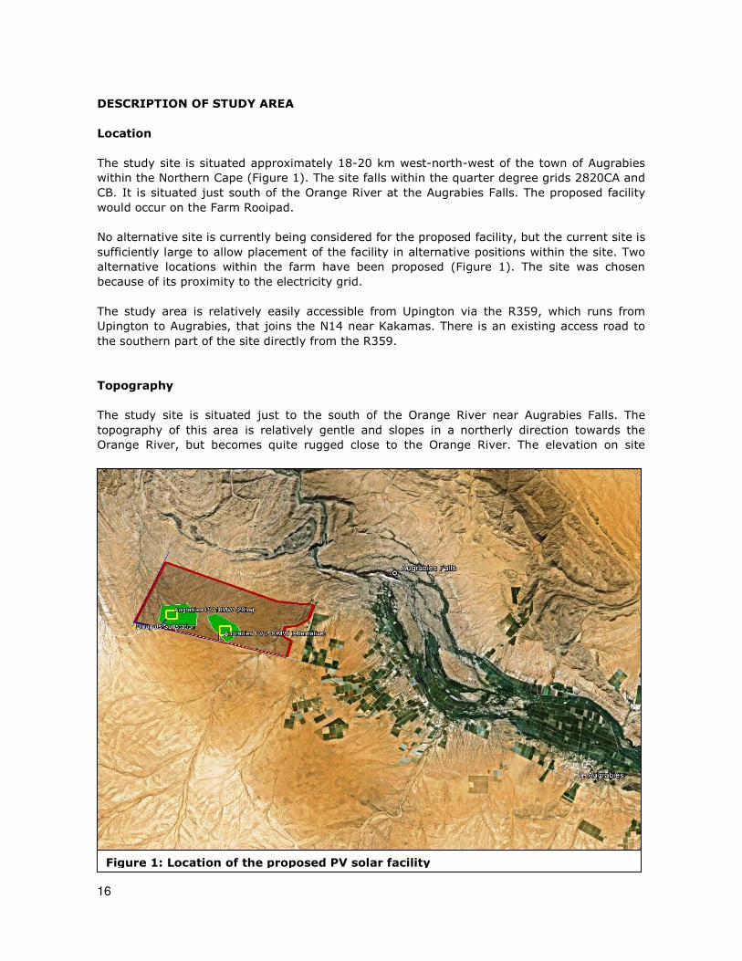
The study site is situated approximately 18-20 km west-north-west of the town of Augrabies
within the Northern Cape (Figure 1). The site falls within the quarter degree grids 2820CA and
CB. It is situated just south of the Orange River at the Augrabies Falls. The proposed facility
would occur on the Farm Rooipad.
No alternative site is currently being considered for the proposed facility, but the current site is
sufficiently large to allow placement of the facility in alternative positions within the site. Two
alternative locations within the farm have been proposed (Figure 1). The site was chosen
because of its proximity to the electricity grid.
The study area is relatively easily accessible from Upington via the R359, which runs from
Upington to Augrabies, that joins the N14 near Kakamas. There is an existing access road to
the southern part of the site directly from the R359.
Topography
The study site is situated just to the south of the Orange River near Augrabies Falls. The
topography of this area is relatively gentle and slopes in a northerly direction towards the
Orange River, but becomes quite rugged close to the Orange River. The elevation on site
Figure 1: Location of the proposed PV solar facility

17
varies from 714 to 723 m above sea level on the preferred site and from 694 to 710 m above
sea level on the alternative site. There are some low ridges on site, and various drainage lines
draining the study area, all non-perennial. These primarily drain in a north-westerly direction
towards the Orange River.
Land types and soils
Detailed soil information is not available for broad areas of the country. As a surrogate,
landtype data was used to provide a general description of soils in the study area (landtypes
are areas with largely uniform soils, topography and climate). There are two land types in the
study area, the Ag and Fb land types (Land Type Survey Staff, 1987), but only the Ag
landtype occurs within the footprint of the alternative sites for the PV facility.
The A-group of land types refer to yellow and red soils without water tables belonging to one
or more of the following soil forms: Inanda, Kranskop, Magwa, Hutton, Griffin, Clovelly. The
Ag land type consists of red, high base status, < 300 mm deep soils and no dunes (MacVicar
et al. 1974).
Climate
The climate is arid to semi-arid. Rainfall occurs from November to April, but peaks in mid- to
late summer (February / March). Mean annual rainfall is 140 mm to 170 mm per year. All
areas with less than 400 mm rainfall are considered to be arid. The study area can therefore
be considered to be arid to very arid.
Landuse and landcover of the study area
A landcover map of the study area (Fairbanks et al. 2000) indicates that the entire site
consists of natural vegetation. The 1:50 000 topocadastral map of the site also indicates that
the site is in a completely natural state, with no infrastructure indicated for the site. A Google
image of the site also confirms this pattern.
Broad vegetation types of the region
The study area falls within the Nama-Karoo Biome (Rutherford & Westfall 1986, Mucina &
Rutherford 2006). The most recent and detailed description of the vegetation of this region is
part of a national map (Mucina, Rutherford & Powrie, 2005; Mucina et al. 2006). This map
shows two vegetation types occurring on site, namely Bushmanland Arid Grassland across
most of the site and a small area of Blouputs Karroid Thornveld in the north-western corner.
Conservation status of broad vegetation types
On the basis of a scientific approach used at national level by SANBI (Driver et al. 2005),
vegetation types can be categorised according to their conservation status which is, in turn,
assessed according to the degree of transformation relative to the expected extent of each
vegetation type. The status of a habitat or vegetation type is based on how much of its
original area still remains intact relative to various thresholds. The original extent of a
vegetation type is as presented in the most recent national vegetation map (Mucina,

18
Rutherford & Powrie 2005) and is the extent of the vegetation type in the absence of any
historical human impact. On a national scale the thresholds are as depicted in Table 2, as
determined by best available scientific approaches (Driver et al. 2005). The level at which an
ecosystem becomes Critically Endangered differs from one ecosystem to another and varies
from 16% to 36% (Driver et al. 2005).
The National List of Ecosystems that are Threatened and in need of protection (GN1002 of
2011), published under the National Environmental Management: Biodiversity Act (Act No. 10,
2004), lists national vegetation types that are afforded protection on the basis of rates of
transformation. The thresholds for listing in this legislation are higher than in the scientific
literature, which means there are fewer ecosystems listed in the Threatened Ecosystem List
versus in the scientific literature.
Both of the vegetation types occurring in the study area (Table 3) are classified as Least
Threatened (Driver et al. 2005; Mucina et al., 2006, Draft Ecosystem List).
Table 3: Conservation status of different vegetation types occurring in the study
area, according to Driver et al. 2005 and Mucina et al. 2005.
Conservation status Vegetation Type Target
(%)
Conserved
(%)
Transformed
(%) Driver et al.
2005; Mucina
et al., 2006
Threatened
Ecosystem List
(NEMBA)
Bushmanland Arid
Grassland
21 0 1 Least Threatened Not listed
Blouputs Karroid
Thornveld
21 28 1 Least Threatened Not listed
General animal diversity on site
Checklists of species with a geographical distribution that includes the site are included in
Appendix 1 of this report. This includes 64 mammal species, 55 reptile species, 11 amphibian
species and 215 bird species. Not all of these species would potentially be found on site. The
presence of any particular species on site depends on the availability of suitable habitat. In
addition, many animals are highly mobile and/or have wide home ranges. They could,
therefore, potentially occur on site, but would not be found there. The actual number of
species likely to be found on site is therefore likely to be considerably less than indicated by
these checklists.
Invertebrates are not covered in this study. Nevertheless, an interesting find was observed by
another specialist on site. Specimens of the tadpole shrimp (Triops granarius) were found in a
shallow, temporary pool on site. Tadpole shrimps inhabit temporary brackish and freshwater
pools in areas with rainfalls below 500mm (Rayner 1999). They are benthic scavengers.
Table 2: Determining ecosystem status (from Driver
et al. 2005). *BT = biodiversity target (the minimum
conservation requirement).
80–100 least threatened LT
60–80 vulnerable VU
*BT–60 endangered EN
Habitat
remaining
(%)
0–*BT critically endangered CR

19
Development is extremely rapid, and all stages are tolerant of high temperatures (Raynor
1999). Eggs of this species are able to survive decades in the sediment of the ponds and lakes
they inhabit and are resistant to drought and temperature extremes. Triops granarius shows
one of the largest geographical distributions among all Notostraca. It ranges from Africa
through the Middle East to India, China and Japan and extends north as far as Mongolia. The
special interest of this record is that it demonstrates the ephemeral nature of ecological
communities in these depressions (and other ecosystems in arid areas), where the right
combination of conditions are required before species may appear.
Animal species of conservation concern of the study area
All Red List vertebrates (mammals, birds, reptiles, amphibians) that could occur in the study
area are listed in Appendix 1. Those vertebrate species with a geographical distribution that
includes the study area, and habitat preference that includes habitats available in the study
area are discussed further.
There are four mammal species of low conservation concern that could occur in available
habitats in the study area. This includes four species classified nationally as Near Threatened
(Friedmann & Daly 2004), i.e. the Honey Badger, Littledale’s Whistling Rat, the Dassies Rat
and Dent’s Horseshoe Bat, all four of which are classified as Least Concern globally (according
to the IUCN website, accessed on 24 February 2012). The Honey Badger is relatively mobile
and is not dependant on the site remaining intact for its survival. Construction disturbance is
likely to displace animals from the site, if they occur there, but will not lead to direct mortality.
Plate 1: Tadpole shrimp (Triops granarius). (Photo from www.treknature.com)

20
Dent’s Horseshoe Bat may traverse the site during foraging, but is not dependant on the site
remaining intact. The other two species are more likely to be site-specific in their distribution.
Littledale’s Whistling Rat is a patchily distributed species and is solitary. It occurs mostly in
sandy areas. If any individuals occur on site, they are likely to be in small numbers only. The
Dassie Rat is found in rocky areas, where it relies on crevices in rocks for shelter. It may be
found as individuals or as small family groups.
There are three threatened bird species (all VU) and three Near Threatened bird species that
have a medium probability of utilising available habitats in the study area, either for foraging
or breeding. The two species most likely to use parts of the site for breeding are the Kori
Bustard and Ludwig’s Bustard, both listed in South Africa as Vulnerable (Barnes 2000,
Chittenden 2007). According to the IUCN website (accessed on 24 February 2012), Kori’s
Bustard is listed globally as Least Concern and Ludwig’s Bustard as Endangered. Sclater's
Lark, listed as Near Threatened, could potentially use the site for breeding. These three
species that could use the site for breeding are also the most likely to be affected by
infrastructure on site and/or loss of habitat.
The species that may use the site only for foraging are the Martial Eagle, listed as Vulnerable,
and the Secretarybird and Lanner Falcon, listed as Near Threatened in South Africa (Barnes
2000, Chittenden 2007). The Secretarybird is listed on the IUCN website (accessed on 24
February 2012) as globally Least Concern. All three of these species have wide ranges and the
site is small in comparison and therefore unlikely to be critical habitat for any of these three
species.
Plate 2: Ludwig’s Bustard.

21
The Giant Bullfrog is the only amphibian species of conservation concern with a distribution
that includes the study area. This species is classified as Least Concern globally (according to
the IUCN website, accessed on 2 August 2011) and Near threatened in South Africa (Branch
1988, du Preez & Carruthers 2009). It is, however, protected under the National
Environmental Management: Biodiversity Act. If any individuals should be found on site, steps
would need to be taken to protect them. The site was not considered to contain habitat
suitable for this species and it is considered unlikely to occur there.
There are no reptile species of conservation concern that have a distribution that includes the
study area.
In summary, the following animal species of conservation concern have a geographical
distribution that includes the site and they could potentially occur on site or nearby:
1. Littledale’s Whistling Rat (NT),
2. Dassie Rat (NT),
3. Ludwig’s Bustard (VU/EN),
4. Kori Bustard (VU/LC),
5. Sclater’s Lark (NT),
6. Martial Eagle (VU),
7. Secretarybird (NT),
8. Lanner Falcon (NT).
However, some of these are unlikely to be affected by activities on site or there is no suitable
habitat on site. Only the following species are considered to be vulnerable to individual
mortality due to activities on site or loss of habitat by development of the site:
1. Littledale’s Whistling Rat (NT),
2. Dassie Rat (NT),
3. Ludwig’s Bustard (VU/EN),
4. Kori Bustard (VU/LC),
5. Sclater’s Lark (NT),
Protected animals (National Environmental Management: Biodiversity Act)
There are a number of animal species protected under the Northern Cape Nature Conservation
Act of 2009 (Act 9 of 2009). These are listed in Appendix 6. According to the Northern Cape
Nature Conservation Act, "No person shall without a permit hunt, import, export, transport,
keep, possess, breed or trade in a specimen of a (specially) protected animal ". The Act does
not imply that habitat for these species should be regarded as sensitive and appears to be
primarily concerned with protecting individual animals from hunting or trading. No permit
requirements are contained in the Act for cases where such individuals may occur on land for
which an application for development is being considered (as in the current case).
Those species protected according to the Northern Cape Nature Conservation Act of 2009 (Act
9 of 2009) that have a geographical distribution that includes the site and that may, therefore,
occur on site are listed in Appendix 3, marked with the letter “P”. A large proportion of the
species (except for the most common) are protected according to the Northern Cape Nature
Conservation Act of 2009 (Act 9 of 2009).
There are a number of animal species protected according to the National Environmental
Management: Biodiversity Act (Act No. 10 of 2004). According to this Act, “a person may not
carry out a restricted activity involving a specimen of a listed threatened or protected species
without a permit issued in terms of Chapter 7”. Such activities include any that are “of a
nature that may negatively impact on the survival of a listed threatened or protected species”.

22
This implies that any negative impacts on habitats in which populations of protected species
occur or are dependent upon would be restricted according to this Act.
Those species protected according to the National Environmental Management: Biodiversity
Act (Act No. 10 of 2004) that have a geographical distribution that includes the site are listed
in Appendix 3, marked with the letter “N”. This includes the following species: White
Rhinoceros, Black Rhinoceros, Hartmann’s Mountain Zebra, Cape Clawless Otter, Honey
Badger, Leopard, Cape Fox, Black Stork, Kori Bustard, Lesser Kestrel, Ludwig’s Bustard,
Martial Eagle and Peregrine Falcon. Due to various factors, including habitat preference,
available habitat on site and occurrence of species outside protected areas, not all these
species are likely to occur on site. Those that are considered to have the potential to occur on
site are the Hartmann’s Mountain Zebra, Honey Badger, Cape Fox, Ludwig’s Bustard
and Kori Bustard.
Sensitivity assessment
The sensitivity assessment identifies those parts of the study area that could (a) possibly have
high conservation value or that (b) may be sensitive to disturbance. An explanation of the
different sensitivity classes is given in Table 1. The features that need to be taken into account
in order to evaluate sensitivity in the study area are the following:
1. perennial and non-perennial rivers and streams: this represents a number of ecological
processes including groundwater dynamics, hydrological processes, nutrient cycling and
Figure 2: Watercourses within the footprint of proposed infrastructure.
23
wildlife dispersal;
2. potential occurrence of populations of Red List organisms that have been evaluated as
having a high chance of occurring within remaining natural habitats within the study
area.
These factors have been taken into account in evaluating sensitivity within the study area
(Figure 2). The sensitivity classification for the site is as follows:
1. HIGH: (i) All of the watercourses on site are classified as having high sensitivity (see
Table 1 and Figure 2). They are protected according to the National Water Act (Act 36
of 1998). Ecologically, they are areas that provide high value ecosystem goods and
services.
2. MEDIUM-HIGH: Remaining natural habitat on site is classified as having medium-high
sensitivity (see Table 1 and Figure 2). These are areas of natural vegetation that are
potential habitat for species of concern (Vulnerable, Near Threatened and/or protected
species), including Ludwig’s Bustard, Kori Bustard and Sclater’s Lark.
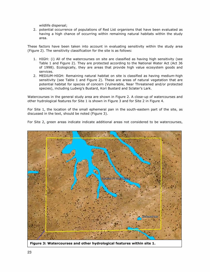
Watercourses in the general study area are shown in Figure 2. A close-up of watercourses and
other hydrological features for Site 1 is shown in Figure 3 and for Site 2 in Figure 4.
For Site 1, the location of the small ephemeral pan in the south-eastern part of the site, as
discussed in the text, should be noted (Figure 3).
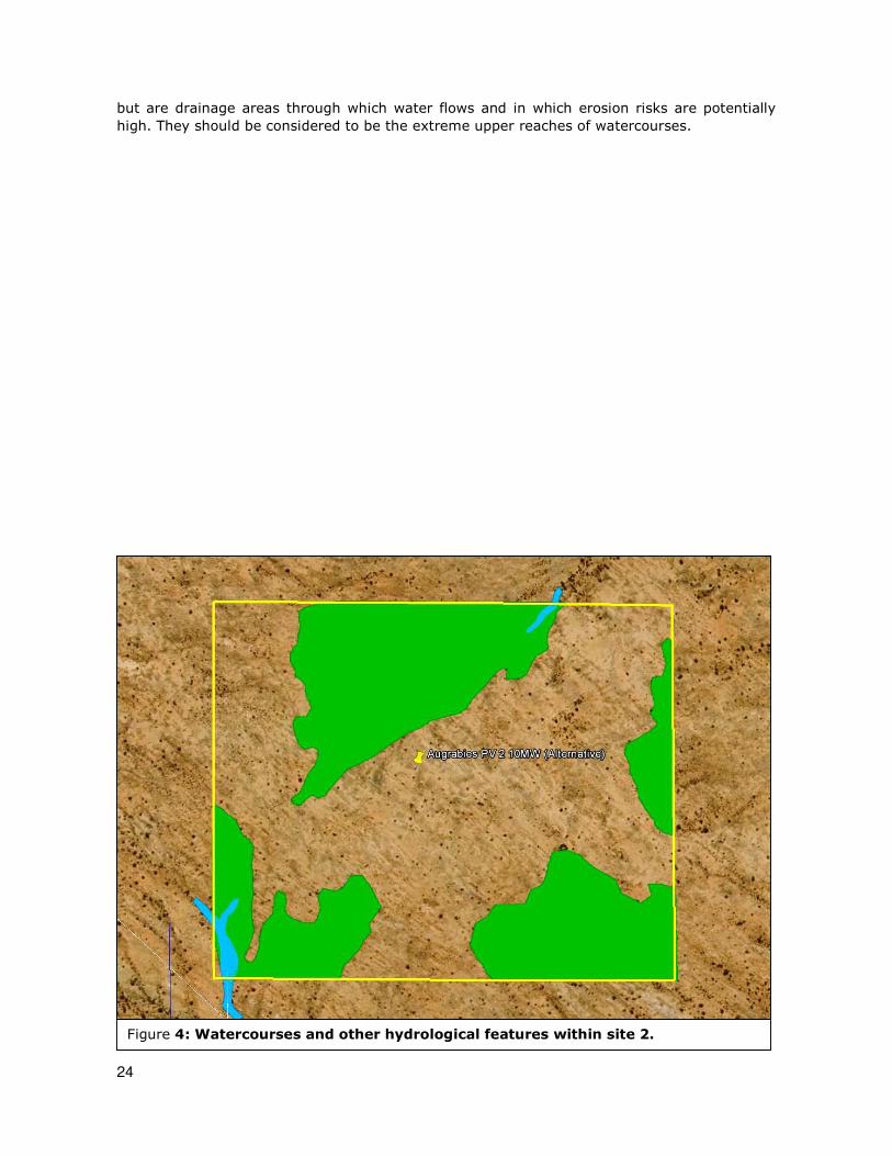
For Site 2, green areas indicate indicate additional areas not considered to be watercourses,
Figure 3: Watercourses and other hydrological features within site 1.
24
but are drainage areas through which water flows and in which erosion risks are potentially
high. They should be considered to be the extreme upper reaches of watercourses.
Figure 4: Watercourses and other hydrological features within site 2.

25
RELEVANT LEGISLATIVE AND PERMIT REQUIREMENTS
Relevant legislation is provided in this section to provide a description of the key legal
considerations of importance to the proposed project. The applicable legislation is listed below.
Legislation
National Environmental Management Act, Act No. 107 of 1998 (NEMA)
NEMA requires, inter alia, that:
• “development must be socially, environmentally, and economically sustainable”,
• “disturbance of ecosystems and loss of biological diversity are avoided, or,
where they cannot be altogether avoided, are minimised and remedied.” ,
• “a risk-averse and cautious approach is applied, which takes into account the
limits of current knowledge about the consequences of decisions and actions”,
NEMA states that “the environment is held in public trust for the people, the beneficial use
of environmental resources must serve the public interest and the environment must be
protected as the people’s common heritage.”
Environment Conservation Act No 73 of 1989 Amendment Notice No R1183 of 1997
The ECA states that:
Development must be environmentally, socially and economically sustainable.
Sustainable development requires the consideration of inter alia the following factors:
• that pollution and degradation of the environment is avoided, or, where they
cannot be altogether avoided, are minimised and remedied; • that the use and exploitation of non-renewable natural resources is
responsible and equitable, and takes into account the consequences of the
depletion of the resource;
• that the development, use and exploitation of renewable resources and the
ecosystems of which they are part do not exceed the level beyond which their
integrity is jeopardised; and
• that negative impacts on the environment and on peoples’ environmental
rights be anticipated and prevented, and where they cannot be altogether
prevented are minimised and remedied.
The developer is required to undertake Environmental Impact Assessments (EIA) for all
projects listed as a Schedule 1 activity in the EIA regulations in order to control
activities which might have a detrimental effect on the environment. Such activities will
only be permitted with written authorisation from a competent authority.
National Forests Act (Act no 84 of 1998)
Protected trees
According to this act, the Minister may declare a tree, group of trees, woodland or a
species of trees as protected. The prohibitions provide that ‘no person may cut,
damage, disturb, destroy or remove any protected tree, or collect, remove, transport,
export, purchase, sell, donate or in any other manner acquire or dispose of any
protected tree, except under a licence granted by the Minister’.
Forests
Prohibits the destruction of indigenous trees in any natural forest without a licence. An
example of a declared forest in the arid region is the dense group of Acacia erioloba
trees at Kathu.
National Environmental Management: Biodiversity Act (Act No 10 of 2004)
In terms of the Biodiversity Act, the developer has a responsibility for:

26
• The conservation of endangered ecosystems and restriction of activities according to
the categorisation of the area (not just by listed activity as specified in the EIA
regulations).
• Promote the application of appropriate environmental management tools in order to
ensure integrated environmental management of activities thereby ensuring that all
development within the area are in line with ecological sustainable development and
protection of biodiversity. • Limit further loss of biodiversity and conserve endangered ecosystems.
Chapter 4 of the Act relates to threatened or protected ecosystems or species. According to
Section 57 of the Act, "Restricted activities involving listed threatened or protected species":
• (1) A person may not carry out a restricted activity involving a specimen of a
listed threatened or protected species without a permit issued in terms of
Chapter 7.
Such activities include any that are “of a nature that may negatively impact on the survival of
a listed threatened or protected species”.
Chapter 5 of the Act relates to species and organisms posing a potential threat to biodiversity.
According to Section 75 of the Act, "Control and eradication of listed invasive species":
• (1) Control and eradication of a listed invasive species must be carried out by
means of methods that are appropriate for the species concerned and the
environment in which it occurs.
• (2) Any action taken to control and eradicate a listed invasive species must be
executed with caution and in a manner that may cause the least possible harm
to biodiversity and damage to the environment.
• (3) The methods employed to control and eradicate a listed invasive species
must also be directed at the offspring, propagating material and re-growth of
such invasive species in order to prevent such species from producing offspring, forming seed, regenerating or re-establishing itself in any manner.
Government Notice No. 1002 of 2011: National List of Ecosystems that are
Threatened and in need of protection
Published under Section 52(1)(a) of the National Environmental Management: Biodiversity Act
(Act No. 10 of 2004). This Act provides for the listing of threatened or protected ecosystems
based on national criteria. The list of threatened terrestrial ecosystems supersedes the
information regarding terrestrial ecosystem status in the National Spatial Biodiversity
Assessment (2004).
The Environmental Impact Assessment (EIA) Regulations include three lists of activities that
require environmental authorisation:
o Listing Notice 1: activities that require a basic assessment (R544 of 2010),
o Listing Notice 2: activities that require scoping and environmental impact report
(EIR) (R545 of 201 0),
o Listing Notice 3: activities that require a basic assessment in specific identified
geographical areas only (R546 of 2010).
Activity 12 in Listing Notice 3 relates to the clearance of 300m2 of more of vegetation, which
will trigger a basic assessment within any critically endangered or endangered ecosystem
listed in terms of S52 of the Biodiversity Act. This means any development that involves loss
of natural habitat in a listed critically endangered or endangered ecosystem is likely to require
at least a basic assessment in terms of the EIA regulations.
It is important to note that while the original extent of each listed ecosystem has been
mapped, a basic assessment report In terms of the EIA regulations is triggered only in

27
remaining natural habitat within each ecosystem and not in portions of the ecosystem where
natural habitat has already been irreversibly lost.
GNR 151: Critically Endangered, Endangered, Vulnerable and Protected Species List
Published under Section 56(1) of the National Environmental Management: Biodiversity Act
(Act No. 10 of 2004).
GNR 1187: Amendment of Critically Endangered, Endangered, Vulnerable and
Protected Species List
Published under Section 56(1) of the National Environmental Management: Biodiversity Act
(Act No. 10 of 2004).
Conservation of Agricultural Resources (Act No. 43 of 1983) as amended in 2001
Declared Weeds and Invaders in South Africa are categorised according to one of the
following categories:
• Category 1 plants: are prohibited and must be controlled.
• Category 2 plants: (commercially used plants) may be grown in demarcated
areas providing that there is a permit and that steps are taken to prevent
their spread.
• Category 3 plants: (ornamentally used plants) may no longer be planted;
existing plants may remain, as long as all reasonable steps are taken to
prevent the spreading thereof, except within the floodline of watercourses and
wetlands.
National Water Act (Act No. 36 of 1998)
Wetlands, riparian zones and watercourses are defined in the Water Act as a water
resource and any activities that are contemplated that could affect the wetlands
requires authorisation (Section 21 of the National Water Act of 1998). A "watercourse”
in terms of the National Water Act (Act 36 of 1998) means:
• River or spring;
• A natural channel in which water flows regularly or intermittently;
• A wetland, lake or dam into which, or from which, water flows; and
Any collection of water which the Minister may, by notice in the gazette, declare to be a
watercourse, and a reference to a watercourse includes, where relevant, its bed and
banks.
National Veld and Forest Fire Act (Act No. 101 of 1998)
Provides requirements for veldfire prevention through firebreaks and required measures for
fire-fighting. Chapter 4 of the Act places a duty on landowners to prepare and maintain
firebreaks. Chapter 5 of the Act places a duty on all landowners to acquire equipment and
have available personnel to fight fires.
Northern Cape Nature Conservation Act, No. 9 of 2009
This Act provides for the sustainable utilisation of wild animals, aquatic biota and
plants; provides for the implementation of the Convention on International Trade in
Endangered Species of Wild Fauna and Flora; provides for offences and penalties for
contravention of the Act; provides for the appointment of nature conservators to
implement the provisions of the Act; and provides for the issuing of permits and other
authorisations. Amongst other regulations, the following may apply to the current
project:
• No person may hunt, import, export, transport, keep, possess, breed or trade in
a specimen of a protected animal.

28
• Boundary fences may not be altered in such a way as to prevent wild animals
from freely moving onto or off of a property;
• Aquatic habitats may not be destroyed or damaged;
• The owner of land upon which an invasive species is found (plant or animal)
must take the necessary steps to eradicate or destroy such species.
The Act provides lists of protected species for the Province.
Other Acts
Other Acts that may apply to biodiversity issues, but which are considered to not apply to the
current site are as follows:
• National Environmental Management Protected Areas Act (Act No. 57 of 2003) • Marine Living Resources Act (Act No. 18 of 1998)
• Sea Birds and Seals Protection Act (Act No. 46 of 1973)
• Lake Areas Development Act (Act No. 39 of 1975)
• Mountain Catchment Areas Act (Act No. 63 of 1970)
• Integrated Coastal Zone Management Act (Act No. 24 of 2008)

29
IDENTIFICATION OF RISKS AND DESCRIPTION OF POTENTIAL IMPACTS
Potential issues relevant to potential impacts on the ecology of the study area include the
following:
• Impacts on biodiversity: this includes any impacts on populations of individual species
of concern, including protected species, and on overall species richness. This includes
impacts on genetic variability, population dynamics, overall species existence or health
and on habitats important for species of concern.
• Impacts on sensitive habitats: this includes impacts on any sensitive or protected
habitats, including indigenous forest and/or woodland and wetland vegetation that
leads to direct or indirect loss of such habitat.
• Impacts on ecosystem function: this includes impacts on any processes or factors that
maintain ecosystem health and character, including the following:
o disruption to nutrient-flow dynamics;
o impedance of movement of material or water;
o habitat fragmentation;
o changes to abiotic environmental conditions;
o changes to disturbance regimes, e.g. increased or decreased incidence of fire;
o changes to successional processes;
o effects on pollinators;
o increased invasion by alien plants.
Changes to factors such as these may lead to a reduction in the resilience of habitats and
ecosystems or loss or change in ecosystem function.
• Secondary and cumulative impacts on ecology: this includes an assessment of the
impacts of the proposed project taken in combination with the impacts of other known
projects for the area or secondary impacts that may arise from changes in the social,
economic or ecological environment.
• Impacts on the economic use of vegetation: this includes any impacts that affect the
productivity or function of ecosystems in such a way as to reduce the economic value
to users, e.g. reduction in grazing capacity, loss of harvestable products. It is a general
consideration of the impact of a project on the supply of so-called ecosystem goods and
services.
A number of direct risks to ecosystems that would result from construction of the proposed
solar energy facility are as follows:
• Clearing of land for construction.
• Construction of access roads.
• Placement of power lines, cables and water pipelines (if applicable).
• Establishment of borrow and spoil areas.
• Chemical contamination of the soil by construction vehicles and machinery.
• Operation of construction camps.
• Storage of materials required for construction.
There are also risks associated with operation of the proposed facility, as follows:
• Maintenance of surrounding vegetation as part of management of the facility.
• Bird impacts with overhead infrastructure, particularly power lines.

30
Description of potential impacts
Impact 1: Loss of habitat for threatened animals
Nature: Threatened animal species are indirectly affected primarily by the overall loss of
habitat, since direct construction impacts can often be avoided due to movement of individuals
from the path of construction. Animals are generally mobile and, in most cases, can move
away from a potential threat.
Threatened species include those classified as critically endangered, endangered or vulnerable.
For any other species a loss of individuals or localised populations is unlikely to lead to a
change in the conservation status of the species. However, in the case of threatened animal
species, loss of a population or individuals could lead to a direct change in the conservation
status of the species. This may arise if the proposed infrastructure is located where it will
impact on such individuals or populations or the habitat that they depend on. Consequences
may include:
1. fragmentation of populations of affected species;
2. reduction in area of occupancy of affected species; and
3. loss of genetic variation within affected species.
These may all lead to a negative change in conservation status of the affected species, which
implies a reduction in the chances of the species overall survival chances.
There are three bird species of potential conservation concern that may make use of habitats
on site for foraging and possibly for breeding. These are the Kori Bustard (listed globally as
Least Concern and nationally as Vulnerable), Ludwig’s Bustard (listed globally as Endangered
and nationally as Vulnerable) and Sclater’s Lark (listed as Near Threatened).
Kori Bustard (VU) occurs in semi-arid regions, within the 100 - 600 mm rainfall isohyet,
particularly in the Nama-Karoo. It is found open plains of the karoo, in highveld grassland, in
Kalahari sandveld, in arid scrub, in Namib Desert, in lightly wooded savanna and in bushveld.
It favours tree-lined watercourses, which are found on site. It is a common to very common
resident in the study area and therefore has a high probability of utilizing the habitat on site.
It has not been previously recorded in the grid or in any of the nearby grids associated with
the Orange River, but has been recorded at a relatively high reporting rate in adjacent grids.
The species is protected according to the National Environmental Management: Biodiversity
Act (Act No. 10 of 2004). Any activities on site that are “of a nature that may negatively
impact on the survival of a listed threatened or protected species” would require a permit in
terms of this Act.
Ludwig’s Bustard (VU) is near-endemic to southern Africa, with its range centred on the Nama
Karoo and Succulent Karoo biomes. It inhabits the open plains of the semi-arid Karoo and
especially in areas where extensive sheep farming is prevalent. It is an uncommon to common
resident in study area and therefore has a moderate probability of utilizing the habitat on site.
It has not been previously recorded in the grid or in any of the nearby grids associated with
the Orange River, but has been recorded at a relatively high reporting rate in adjacent grids to
the south of the river. The species is protected according to the National Environmental
Management: Biodiversity Act (Act No. 10 of 2004). Any activities on site that are “of a nature
that may negatively impact on the survival of a listed threatened or protected species” would
require a permit in terms of this Act.
Sclater’s Lark (NT) is endemic to South Africa and southern Namibia and is confined to the
Nama Karoo, concentrated in the Northern Cape. It is an uncommon resident in the study

31
area, but is nowhere common in its entire geographic range. It is of lower conservation
concern than the other species described above and is not considered to be threatened. It is
not listed as protected according to the National Environmental Management: Biodiversity Act
(Act No. 10 of 2004).
Littledale’s Whistling Rat and the Dassie Rat are two small mammal species that could
potentially occur on site. They are both listed as Near Threatened and are, therefore, not of
very high conservation concern. Neither species is listed as protected according to the National
Environmental Management: Biodiversity Act (Act No. 10 of 2004).
Impact 2: Bird collisions with powerlines
Nature: Threatened bird species may be directly affected by collisions with overhead
powerlines. Cranes, bustards, flamingos, waterfowl, shorebirds, gamebirds and falcons are
among the most frequently affected (Jenkins et al. 2010). Ludwig’s Bustard is especially
affected by collisions with overhead power lines.
There are three bird species of potential conservation concern that may make use of habitats
on site for foraging and possibly for breeding. These are the Kori Bustard (listed globally as
Least Concern and nationally as Vulnerable), Ludwig’s Bustard (listed globally as Endangered
and nationally as Vulnerable) and Sclater’s Lark (listed as Near Threatened). The two bustards
are particularly vulnerable to being affected by collisions with overhead power lines.
The species that may use the site only for foraging are the Martial Eagle, listed as Vulnerable,
and the Secretarybird and Lanner Falcon, listed as Near Threatened in South Africa (Barnes
2000, Chittenden 2007).
Impact 3: Impacts on watercourses, drainage areas and ephemeral pans
Nature: The site is in a very arid area. There are no proper wetlands on site, but there are a
number of dry stream beds, drainage areas and watercourses. According to the National Water
Act, these are classified as wetlands or water resources. Construction may lead to some direct
or indirect loss of or damage to some of these areas or changes to the catchment of these
areas. This may affect the hydrology of the landscape or lead to loss of habitat for species that
depend on this habitat type. Dry river beds and drainage lines are an important habitat for a
number of species in the study area, including those with a restricted distribution or species
with an elevated conservation status.
A single small depression occurs on Site 1 in which shallow water was found at the time of
field surveys for the project. Within this shallow water, specimens of Triops granarius was
found. The fact that the Triops occurs within the depression indicates that water occurs in that
depression regularly enough to support a unique biological assemblage and indicate that this is
an ephemeral pan, albeit very small.

32
ASSESSMENT OF IMPACTS
Impacts are assessed for each infrastructure component. These are grouped according to the
expected impact on the receiving environment as follows:
1. solar array, substation and on-site component of access road.
2. Overhead power line.
Solar arrays, substation and access road
Impact 1: Loss of habitat for threatened animals
There is a low likelihood of any threatened or near threatened animal species being affected
by the proposed project. Birds and other animals that could potentially occur on site are
relatively mobile and will move away during construction. The footprint of the solar array is
small relative to the overall availability of habitat in the general area. The potential impact on
them due to a loss of a small area of habitat is therefore not considered to be serious.
Duration: In localised areas, the impact will be permanent due to the fact that clearing of
habitat for construction purposes cannot be reversed.
Extent: The impact will occur at the site of the proposed solar arrays. In all cases, the area of
concern is likely to be limited in extent and is scored as local.
Magnitude: At a local scale, the potential magnitude of this impact will probably be minor (will
not have an effect on population processes for any of the species of concern).
Probability: The probability of the impact occurring is rated as improbable. If any species occur
on site, they will not be critically dependant on the small area of habitat that will be lost.
Mitigation measures: Ensure that construction impacts are contained to within the footprint of
the proposed infrastructure and do not spread into surrounding natural areas.
Nature: Loss of habitat for threatened animals
Without mitigation With mitigation
Extent Local (1) Local (1)
Duration Permanent (5) Permanent (5)
Magnitude minor (2) small (1)
Probability Improbable (2) Improbable (2)
Significance Low (16) Low (14)
Status (positive or negative) Negative Negative
Reversibility Reversible to some degree Reversible to some degree
Irreplaceable loss of
resources?
No No
Can impacts be mitigated? To a small degree only
Mitigation:
Ensure that construction impacts are contained within the footprint of the proposed infrastructure and do not spread into surrounding natural areas.
Cumulative impacts:
None
Residual Impacts:
None likely
33
*Significance calculated as (magnitude+duration+extent) x probability. Significance: <30 = low, 30–60 = medium,
>60 = high.
Impact 2: Bird collisions with power lines
This impact is not assessed for this infrastructure component.
Impact 3: Damage to watercourses/pans
There are a number of dry stream beds and drainage areas on site as well as one small
ephemeral pan. According to the National Water Act, these are classified as water resources.
Construction may lead to some direct or indirect loss of or damage to these affected areas or
changes to the catchment of these areas.
Extent: The impact will occur at the site of the proposed solar array, but could have
downstream impacts. The extent of the potential impact is therefore on the site and
surroundings.
Duration: The impact will occur during construction, but will probably result in impacts that
have a long-term effects.
Magnitude: In the long-term, impacts could result in processes continuing but in a modified
way, which is scored as moderate.
Probability: According to the provided plan, it is definite that the impact will occur.
Mitigation measures:
1. If possible from a technical point of view, solar arrays should be positioned in such a
way as to fall a minimum of 30 m outside defined watercourses and pans.
2. Ground surfaces within the solar array must be properly maintained to avoid erosion
impacts.
3. A storm-water management plan must be compiled for the solar array. This must
indicate how water velocities will be reduced before storm water is allowed to enter
natural channels and how natural processes for water infiltration of the affected
landscape will be accommodated.
4. There is a legal obligation to apply for a Water Use Licence (WUL) for any water
resource that may be affected, as defined in the National Water Act. Any activity within
500 m of a watercourse or pan boundary may require a WUL, depending on the
activity.
5. The exact extent and location of water resource, as defined in the National Water Act, must be determined. The map provided in this report (Figure 2) serves as a desktop
approximation, but a specialist in this field should undertake a more comprehensive
field study in order to confirm the location of boundaries of such features.
Nature: Damage to wetland / watercourse areas resulting in hydrological impacts
Without mitigation With mitigation
Extent local and surroundings (2) local and surroundings (2)
Duration Long-term (4) Long-term (4)
Magnitude Moderate (6) Low (4)
Probability definite (5) Highly probable (4)
Significance medium (60) medium (40)
Status (positive or negative) Negative negative
Reversibility Reversible with effective
rehabilitation
Reversible
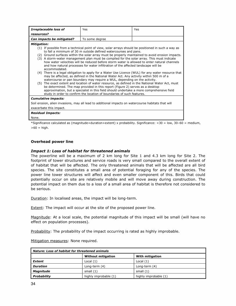
34
Irreplaceable loss of
resources?
Yes Yes
Can impacts be mitigated? To some degree
Mitigation:
(1) If possible from a technical point of view, solar arrays should be positioned in such a way as to fall a minimum of 30 m outside defined watercourses and pans.
(2) Ground surfaces within the solar array must be properly maintained to avoid erosion impacts. (3) A storm-water management plan must be compiled for the solar array. This must indicate
how water velocities will be reduced before storm water is allowed to enter natural channels and how natural processes for water infiltration of the affected landscape will be accommodated.
(4) There is a legal obligation to apply for a Water Use Licence (WUL) for any water resource that may be affected, as defined in the National Water Act. Any activity within 500 m of a watercourse or pan boundary may require a WUL, depending on the activity.
(5) The exact extent and location of water resource, as defined in the National Water Act, must be determined. The map provided in this report (Figure 2) serves as a desktop approximation, but a specialist in this field should undertake a more comprehensive field study in order to confirm the location of boundaries of such features.
Cumulative impacts:
Soil erosion, alien invasions, may all lead to additional impacts on watercourse habitats that will
exacerbate this impact.
Residual Impacts:
None.
*Significance calculated as (magnitude+duration+extent) x probability. Significance: <30 = low, 30–60 = medium,
>60 = high.
Overhead power line
Impact 1: Loss of habitat for threatened animals
The powerline will be a maximum of 2 km long for Site 1 and 4.3 km long for Site 2. The
footprint of tower structures and service roads is very small compared to the overall extent of
of habitat that will be affected. The only threatened animals that will be affected are all bird
species. The site constitutes a small area of potential foraging for any of the species. The
power line tower structures will affect and even smaller component of this. Birds that could
potentially occur on site are relatively mobile and will move away during construction. The
potential impact on them due to a loss of a small area of habitat is therefore not considered to
be serious.
Duration: In localised areas, the impact will be long-term.
Extent: The impact will occur at the site of the proposed power line.
Magnitude: At a local scale, the potential magnitude of this impact will be small (will have no
effect on population processes).
Probability: The probability of the impact occurring is rated as highly improbable.
Mitigation measures: None required.
Nature: Loss of habitat for threatened animals
Without mitigation With mitigation
Extent Local (1) Local (1)
Duration Long-term (4) Long-term (4)
Magnitude small (1) small (1)
Probability highly improbable (1) highly improbable (1)
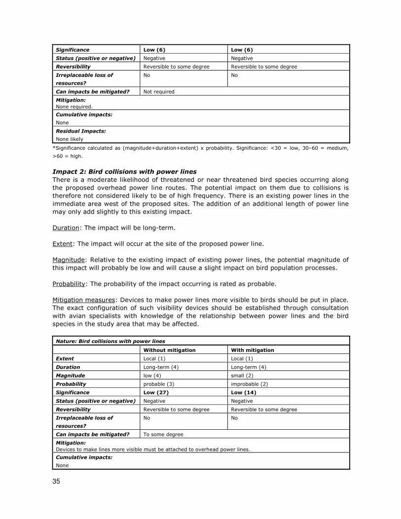
35
Significance Low (6) Low (6)
Status (positive or negative) Negative Negative
Reversibility Reversible to some degree Reversible to some degree
Irreplaceable loss of
resources?
No No
Can impacts be mitigated? Not required
Mitigation:
None required.
Cumulative impacts:
None
Residual Impacts:
None likely
*Significance calculated as (magnitude+duration+extent) x probability. Significance: <30 = low, 30–60 = medium,
>60 = high.
Impact 2: Bird collisions with power lines
There is a moderate likelihood of threatened or near threatened bird species occurring along
the proposed overhead power line routes. The potential impact on them due to collisions is
therefore not considered likely to be of high frequency. There is an existing power lines in the
immediate area west of the proposed sites. The addition of an additional length of power line
may only add slightly to this existing impact.
Duration: The impact will be long-term.
Extent: The impact will occur at the site of the proposed power line.
Magnitude: Relative to the existing impact of existing power lines, the potential magnitude of
this impact will probably be low and will cause a slight impact on bird population processes.
Probability: The probability of the impact occurring is rated as probable.
Mitigation measures: Devices to make power lines more visible to birds should be put in place.
The exact configuration of such visibility devices should be established through consultation
with avian specialists with knowledge of the relationship between power lines and the bird
species in the study area that may be affected.
Nature: Bird collisions with power lines
Without mitigation With mitigation
Extent Local (1) Local (1)
Duration Long-term (4) Long-term (4)
Magnitude low (4) small (2)
Probability probable (3) improbable (2)
Significance Low (27) Low (14)
Status (positive or negative) Negative Negative
Reversibility Reversible to some degree Reversible to some degree
Irreplaceable loss of
resources?
No No
Can impacts be mitigated? To some degree
Mitigation:
Devices to make lines more visible must be attached to overhead power lines.
Cumulative impacts:
None

36
Residual Impacts:
None likely
*Significance calculated as (magnitude+duration+extent) x probability. Significance: <30 = low, 30–60 = medium,
>60 = high.
Impact 3: Damage to wetlands/watercourses
There are a number of dry stream beds and drainage areas on site. According to the National
Water Act, these are classified as water resources. Construction may lead to some direct or
indirect loss of or damage to these affected areas or changes to the catchment of these areas.
The power line from Site 1 is approximately half the length of that from Site 2, but the power
line from Site 2 runs mostly alongside an existing road.
Extent: The impact will occur at the site of the proposed power line or service roads, but could
have downstream impacts. The extent of the potential impact is therefore on the site and
surroundings.
Duration: The impact will occur during construction, but will probably result in impacts that
have a long-term to permanent effect. For example, loss of habitat within serice roads, erosion
of substrates downstream of infrastructure, changes to channel morphology, increased
channelization due to concentration of water-flow.
Magnitude: In the long-term, impacts could result in processes continuing but in a modified
way, which is scored as moderate.
Probability: According to the provided plan, it is probable that the impact will occur.
Mitigation measures:
1. Pylons must be positioned a minimum of 50 m outside of watercourse boundaries.
2. Existing roads must be used as service roads, where possible.
3. There is a legal obligation to apply for a Water Use Licence (WUL) for any wetlands that
may be affected, since they are classified in the National Water Act as a water
resource. Any activity within 500 m of a wetland or watercourse boundary may require
a WUL, depending on the activity.
Nature: Damage to wetland / watercourse areas resulting in hydrological impacts
Without mitigation With mitigation
Extent local and surroundings (2) local and surroundings (2)
Duration Long-term (4) Long-term (4)
Magnitude Moderate (6) Low (4)
Probability probable (3) improbable (2)
Significance medium (36) low (20)
Status (positive or negative) Negative negative
Reversibility Reversible with effective
rehabilitation
Reversible
Irreplaceable loss of
resources?
Yes Yes
Can impacts be mitigated? To some degree
Mitigation:
(1) Pylons must be positioned a minimum of 50 m outside of watercourse boundaries. (2) Existing roads must be used as service roads, where possible.
(3) There is a legal obligation to apply for a Water Use Licence for any wetlands that may be affected, since they are classified in the National Water Act as a water resource. Any activity within 500 m of a wetland or watercourse boundary may require a WUL, depending on the

37
activity.
Cumulative impacts:
Soil erosion, alien invasions, may all lead to additional impacts on watercourse habitats that will
exacerbate this impact.
Residual Impacts:
None.
*Significance calculated as (magnitude+duration+extent) x probability. Significance: <30 = low, 30–60 = medium,
>60 = high.

38
DISCUSSION AND CONCLUSIONS
Most of the study area is in a natural condition. There is very little evidence of transformation
or degradation. Factors that may lead to parts of the study area having elevated ecological
sensitivity are the presence of dry watercourses on site, one small ephemeral pan/depression
and the potential presence of various animal species of conservation concern. Watercourses
represent particularly vital natural corridors as they function both as wildlife habitat, providing
resources needed for survival, reproduction and movement, and as biological corridors,
providing for movement between habitat patches. Watercourses are protected under national
legislation (National Water Act). Any impacts on these areas would require a permit from the
National Department of Water Affairs.
There are four mammal species of low conservation concern that could occur in available
habitats in the study area, i.e. the Honey Badger, Littledale’s Whistling Rat, the Dassies Rat
and Dent’s Horseshoe Bat, all four of which are listed nationally as Near Threatened and
globally as Least Concern.
There are three threatened bird species (all VU) and three Near Threatened bird species that
have a medium probability of utilising available habitats in the study area, either for foraging
or breeding. The three species most likely to use parts of the site for breeding are Ludwig’s
Bustard (listed globally as Endangered), the Kori Bustard (listed globally as Least Concern and
nationally as Vulnerable) and Sclater’s Lark (listed globally and nationally as Near
Threatened). The species that may use the site only for foraging are the Martial Eagle, listed
as Vulnerable, and the Secretarybird and Lanner Falcon, listed as Near Threatened.
There are a small number of animal species protected according to the National Environmental
Management: Biodiversity Act (Act No. 10 of 2004) that have a geographical distribution that
includes the site and that may occur on site. These are the Hartmann’s Mountain Zebra, Honey
Badger and Cape Fox. These three species are unlikely to be affected by development of the
site. No signs of them were found on site, but, if they occur there, they are mobile species
that are likely to move away during construction of the facility.
A risk assessment was undertaken which identified three main potential negative impacts on
the ecological receiving environment. The identified potential impacts are the following:
1. Impacts on habitat of threatened animals.
2. Bird collisions with power lines.
3. Impacts on watercourses and drainage areas
A summary of the significance of impacts before and after mitigation is given in Table 4 below.
This shows that the potential impact on natural vegetation and on watercourses by the solar
arrays are the impacts with a significance of “medium” after mitigation. This significance score
is due to the fact that the impact will be long-term, may have an impact on processes and will
definitely occur. No mitigation measures will reduce the significance of this impact further. All
other potential impacts are either “low” or can be reduced to “low” with mitigation.
Conclusion
The overall impacts of this proposed project are of low or medium significance. With mitigation
measures implemented, it should be possible to reduce most negative impacts to low
significance, except for the significance of the impacts of the solar array on watercourses,
39
which remains medium. Taking this assessment into consideration, this project is supported
from an ecological point of view, on condition reasonable mitigation measures are
implemented to manage impacts.
The most important potential impact is on hydrological systems. If possible, the arrangement
of infrastructure should be reconsidered to avoid directly impacting on these systems. The
alternative site (Site 2) appears to be more suitable in this respect than the preferred site
(Site 1). However, either site can be considered potentially suitable for the proposed
development.

40
Table 4: Summary of the significance of impacts for different infrastructure components before and after mitigation.
Impact Solar arrays & associated
infrastructure
Overhead power lines
Without mitigation With mitigation Without mitigation With mitigation
1. Habitat of threatened animals low
(16)
low
(14)
low
(6)
low
(6)
2. Bird collisions with power lines zero
(0)
zero
(0)
low
(27)
low
(14)
3. Damage to watercourses, drainage
areas & ephemeral pans medium
(60)
medium
(40)
medium
(36)
low
(20)
*Significance calculated as (magnitude+duration+extent) x probability. Significance: <30 = low, 30–60 = medium, >60 = high.

41
MANAGEMENT PLAN
Control measures are only proposed for those impacts where mitigation measures are
proposed to reduce the significance of impacts, i.e. some impacts are of low significance and
thus no mitigation measures are proposed or no mitigation measures are possible or required.
Impacts on habitat of threatened animals
OBJECTIVE: Limit impacts on habitat of threatened animals Project component/s Any infrastructure or activity that will result in disturbance to habitat suitable for
threatened animal species or to populations of threatened animal species
Potential Impact Loss of habitat suitable for populations of threatened animal species or direct loss of individuals of threatened animals
Activity/risk source Construction, operation, environmental management
Mitigation: Target/Objective
Target: no significant impacts on identified suitable habitat or populations of threatened animal species within project control area Time period: construction, operation
Mitigation: Action/control Responsibility Timeframe
(1) Ensure that construction impacts are contained within the footprint of the proposed infrastructure and do not spread into surrounding natural areas.
Construction team, management (environmental officer),
construction, operation
Performance Indicator No significant loss of individuals of threatened animal species
Monitoring • None required.

42
Bird collisions with overhead power lines
OBJECTIVE: Limit impacts on threatened birds due to collisions with power lines
Project component/s Overhead power lines
Potential Impact Loss of individuals of threatened bird species (especially Bustards) due to collisions
with overhead power lines.
Activity/risk source Operation of power line
Mitigation:
Target/Objective
Target: limit loss of individuals of threatened birds due to collision with overhead
power lines
Time period: operation
Mitigation: Action/control Responsibility Timeframe
(1) Attach devices to overhead power lines to make them more visible to affected bird species. The exact nature of such devices should be determined in consulation with a
bird specialist.
Environmental
management team,
management
(environmental officer)
Operation
Performance Indicator No loss of threatned birds due to collisions with power lines
Monitoring • Bird mortality along power line due to collisions
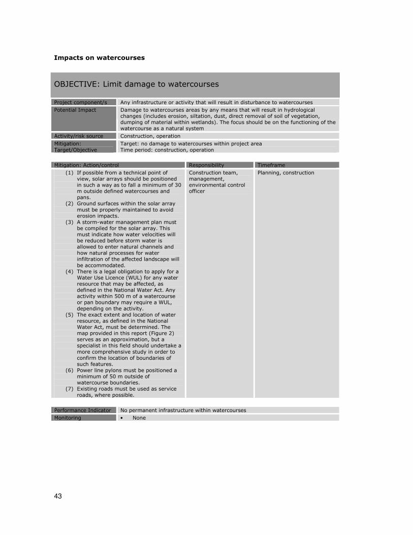
43
Impacts on watercourses
OBJECTIVE: Limit damage to watercourses Project component/s Any infrastructure or activity that will result in disturbance to watercourses
Potential Impact Damage to watercourses areas by any means that will result in hydrological changes (includes erosion, siltation, dust, direct removal of soil of vegetation, dumping of material within wetlands). The focus should be on the functioning of the watercourse as a natural system
Activity/risk source Construction, operation
Mitigation:
Target/Objective
Target: no damage to watercourses within project area
Time period: construction, operation
Mitigation: Action/control Responsibility Timeframe
(1) If possible from a technical point of view, solar arrays should be positioned in such a way as to fall a minimum of 30 m outside defined watercourses and pans.
(2) Ground surfaces within the solar array
must be properly maintained to avoid erosion impacts.
(3) A storm-water management plan must be compiled for the solar array. This must indicate how water velocities will be reduced before storm water is allowed to enter natural channels and how natural processes for water infiltration of the affected landscape will
be accommodated. (4) There is a legal obligation to apply for a
Water Use Licence (WUL) for any water resource that may be affected, as defined in the National Water Act. Any activity within 500 m of a watercourse or pan boundary may require a WUL,
depending on the activity. (5) The exact extent and location of water
resource, as defined in the National Water Act, must be determined. The map provided in this report (Figure 2) serves as an approximation, but a specialist in this field should undertake a
more comprehensive study in order to confirm the location of boundaries of such features.
(6) Power line pylons must be positioned a minimum of 50 m outside of watercourse boundaries.
(7) Existing roads must be used as service
roads, where possible.
Construction team, management, environmental control officer
Planning, construction
Performance Indicator No permanent infrastructure within watercourses
Monitoring • None

44
REFERENCES:
ALEXANDER, G. & MARAIS, J. 2007. A guide to the reptiles of southern Africa. Struik, Cape
Town.
BARNES, K.N. (ed.) (2000) The Eskom Red Data Book of Birds of South Africa, Lesotho and
Swaziland. Birdlife South Africa, Johannesburg.
BRANCH, W.R. (1988) South African Red Data Book—Reptiles and Amphibians. South African
National Scientific Programmes Report No. 151.
CHITTENDEN, H. 2007. Roberts bird guide: a comprehensive field guide to over 950 bird
species in southern Africa. John Voelcker Bird Book Fund, Cape Town.
DENT, M.C., LYNCH, S.D. & SCHULZE, R.E. 1989. Mapping mean annual and other rainfall
statistics in southern Africa. Department of Agricultural Engineering, University of
Natal. ACRU Report No. 27. Massachusetts: Clark University.
DRIVER, A., MAZE, K., ROUGET, M., LOMBARD, A.T., NEL, J., TURPIE, J.K., COWLING, R.M.,
DESMET, P., GOODMAN, P., HARRIS, J., JONAS, Z., REYERS, B., SINK, K and
STRAUSS, T. 2005. National Spatial Biodiversity Assessment 2004: priorities for
biodiversity conservation in South Africa. Strelitzia 17. South African National
Biodiversity Institute, Pretoria.
DU PREEZ, L. & CARRUTHERS, V. 2009. A complete guide to the frogs of southern Africa.
Random House Struik, Cape Town.
FAIRBANKS, D.H.K., THOMPSON, M.W., VINK, D.E., NEWBY, T.S., VAN DEN BERG, H.M &
EVERARD, D.A. 2000. The South African Land-Cover Characteristics Database: a
synopsis of the landscape. S.Afr.J.Science 96: 69-82.
FRIEDMANN, Y. & DALY, B. (eds.) 2004. The Red Data Book of the Mammals of South Africa: A
Conservation Assessment: CBSG Southern Africa, Conservation Breeding Specialist
Group (SSC/IUCN), Endangered Wildlife Trust, South Africa.
IUCN (2001). IUCN Red Data List categories and criteria: Version 3.1. IUCN Species Survival
Commission: Gland, Switzerland.
MACVICAR, C. N., SCOTNEY, D. M. SKINNER, T. E. NIEHAUS, H. S. & LOUBSER, J. H., 1974. A
classification of land (climate, terrain form, soil) primarily for rainfed agriculture. S. Afr.
J. Agric. Extension, 3(3): 1-4.
MARAIS, J. 2004. A complete guide to the snakes of southern Africa. Struik Publishers, Cape
Town.
MILLS, G. & HES, L. 1997. The complete book of southern African mammals. Struik Publishers,
Cape Town.
MINTER, L.R., BURGER, M., HARRISON, J.A., BRAACK, H.H., BISHOP, P.J. and KLOEPFER, D.
(eds.) 2004. Atlas and Red Data Book of the Frogs of South Africa, Lesotho and
Swaziland. SI/MAB Series #9. Smithsonian Institution, Washington, DC.
MONADJEM, A., TAYLOR, P.J., COTTERILL, E.P.D. & SCHOEMAN, M.C. 2010. Bats of southern and
central Africa. Wits University Press, Johannesburg.
MUCINA, L. AND RUTHERFORD, M.C. (editors) 2006. Vegetation map of South Africa, Lesotho
and Swaziland: an illustrated guide. Strelitzia 19, South African National Biodiversity
Institute, Pretoria.
MUCINA, L., RUTHERFORD, M.C. AND POWRIE, I.W. (editors) 2005. Vegetation map of South
Africa, Lesotho and Swaziland, 1:1 000 000 SCALE SHEET MAPS South African National
Biodiversity Institute, Pretoria.
MUCINA, L., RUTHERFORD, M.C., PALMER, A.R., MILTON, S.J., SCOTT, L., VAN DER MERWE,
B., HOARE, D.B., BEZUIDENHOUT, H., VLOK, J.H.J., EUSTON-BROWN, D.I.W.,
POWRIE, L.W. & DOLD, A.P. 2006. Nama-Karoo Biome. In: Mucina, L. & Rutherford,
M.C. (eds.) The vegetation of South Africa, Lesotho and Swaziland. Strelitzia 19. South
African National Biodiversity Institute, Pretoria.

45
PASSMORE, N.I. & CARRUTHERS, V.C. (1995) South African Frogs; a complete guide.
Southern Book Publishers and Witwatersrand University Press. Johannesburg.
RAYNER, N. 1999. Notostraca. Pp. 7-13. In: Day, J.A., Stewart, B.A., de Moor, I.J. & Louw,
A.E. (eds.) Freshwater Inverebrates of Southern Africa. Crustacea I: Notostraca,
Anostraca, Conchostraca and Cladocera. Water Research Commission Report TT
121/00, Pretoria.
RUTHERFORD, M.C. & WESTFALL, R.H. (1994). Biomes of southern Africa: an objective
categorization. Memoirs of the Botanical Survey of South Africa No. 63.
TOLLEY, K. & BURGER, M. 2007. Chameleons of southern Africa. Struik Publishers, Cape Town.

46
APPENDICES:
Appendix 1: Animal species with a geographical distribution that includes the study
area.
Notes:
1. Species of conservation concern are in red lettering.
2. Species protected according to the Northern Cape Nature Conservation Act of 2000 (Act
9 of 2009) marked with “P”
3. Species protected according to the National Environmental Management: Biodiversity
Act of 2004 (Act 10 of 2000) marked with “N”
Mammals: PSpringbok PRed hartebeest NPWhite rhinoceros NPBlack rhinoceros NPHartmann’s mountain zebra PGiraffe
Klipspringer PGemsbok PSteenbok PCommon duiker PEland
Rock hyrax NPCape clawless otter PWater mongoose
Black-backed jackal
Caracal PYellow mongoose PAfrican wild cat PSmall grey mongoose PSlender mongoose PSmall-spotted genet PStriped polecat NPHoney badger PBat-eared fox NPLeopard PAardwolf PSuricate NPCape fox PCape serotine bat PEgyptian slit-faced bat PDarling's horseshoe bat PDent’s Horseshoe Bat PFlat-headed free-tail bat PEgyptian free-tailed bat PReddish-grey musk shrew PLesser red musk shrew PCape/Desert hare PScrub/Savannah hare
Vervet monkey
Chacma baboon PNamaqua rock mouse
PShort-tailed gerbil PHairy-footed gerbil PBrush-tailed hairy-footed gerbil PSpectacled dormouse PPorcupine PLarge-eared mouse PMultimammate mouse PBrant’s whistling rat PLittledale’s whistling rat PBlack-tailed tree rat PTree rat (recorded in AFNP) PSpringhare PDassie rat PPygmy rock mouse PStriped mouse PPouched mouse PHighveld gerbil PBushveld gerbil PCape ground squirrel PBushveld elephant-shrew PSmith’s rock elephant-shrew PRound-eared elephant shrew PAardvark
Reptiles:
(PCommon flap-necked chameleon) PNamaqua chameleon PPuff adder PHorned adder PDesert mountain adder PCape cobra PBlack spitting cobra PCoral snake / coral shield cobra PDwarf beaked snake PKaroo whip snake PKalahari sand snake PBeetz’s tiger snake PBrown house snake PMole snake PSouth-western shovel-snout PCommon wolf snake PBicoloured quill-snouted snake

47
PCommon egg-eater PDamara tiger snake
(PDelalande's beaked blind snake) PSchinz's beaked blind snake PNamaqua worm snake PSouthern rock agama PCommon ground agama PAnchieta’s agama PWater monitor PWestern sandveld lizard PPlain sand lizard PSpotted desert lizard PWestern sandveld lizard PNamaqua sand lizard PSpotted sand lizard PDwarf plated lizard PKalahari dwarf worm lizard PDusky spade-snouted worm lizard PKalahari tree skink PStriped legless skink PWestern rock skink PCape skink PWestern three-striped skink PVariegated skink PKaroo girdled lizard PAugrabies flat lizard PGiant ground gecko PBradfield’s dwarf gecko PBibron’s tubercled gecko PStriped ground gecko PCape gecko PRough gecko PMarico gecko PWestern spotted gecko PAugrabies gecko PCommon barking gecko PLeopard tortoise PKaroo tent tortoise
Amphibians PGuttural toad
(PWestern olive toad) PKaroo toad PRaucous toad PMarbled rubber frog PCommon platanna PBoettger’s caco PCommon river frog NPGiant bullfrog PTremolo sand frog PTandy’s sand frog
Birds: PAfrican Black Duck PAfrican Fish Eagle PAfrican Hoopoe PAfrican Marsh Warbler PAfrican Pied Wagtail PAfrican Rail PAlpine Swift PAnteating Chat PAshy Tit PBarn Owl PBlack Crake PBlack Crow PBlack Eagle PBlack Harrier PBlack Kite NPBlack Stork PBlackbreasted Snake Eagle PBlackchested Prinia PBlackcrowned Night Heron PBlackeared Finchlark PBlackheaded Canary PBlackheaded Heron PBlackshouldered Kite PBlacksmith Plover PBlackthroated Canary PBlackwinged Stilt PBokmakierie PBooted Eagle PBradfield's Lark PBradfield's Swift PBrownthroated Martin PBrubru PBurchell's Courser PCape Bunting PCape Francolin PCape Penduline Tit PCape Reed Warbler PCape Robin PCape Shoveller PCape Sparrow PCape Teal PCape Turtle Dove PCape Wagtail PCape Weaver PCapped Wheatear PCardinal Woodpecker PCattle Egret PChat Flycatcher PChestnutbanded Plover PCinnamonbreasted Warbler PCommon Moorhen PCommon Quail

48
PCommon Sandpiper PCommon Waxbill PCrowned Plover PCurlew Sandpiper PDabchick PDamara Canary PDarter PDesert Cisticola PDiederik Cuckoo PDoublebanded Courser PDoublebanded Sandgrouse PDusky Sunbird PEastern Clapper Lark PEgyptian Goose PEurasian Bee-eater PEurasian Swallow PEurasian Swift PFairy Flycatcher PFamiliar Chat PFantailed Cisticola PFawncoloured Lark PFeral Pigeon PFiscal Shrike PForktailed Drongo PFreckled Nightjar PGabar Goshawk PGarden Warbler PGiant Eagle Owl PGiant Kingfisher PGlossy Starling PGoldentailed Woodpecker PGoliath Heron PGrassveld Pipit PGreater Flamingo PGreater Kestrel PGreater Striped Swallow PGreenshank PGrey Heron PGreybacked Cisticola PGreybacked Finchlark PGymnogene PHadeda Ibis PHamerkop PHelmeted Guineafowl PHouse Sparrow PJackal Buzzard PKalahari Robin PKaroo Chat PKaroo Korhaan PKaroo Longbilled Lark PKaroo Prinia PKaroo Robin PKaroo Thrush
NPKori Bustard PLanner Falcon PLarklike Bunting PLaughing Dove PLayard's Titbabbler PLesser Doublecollared Sunbird PLesser Flamingo PLesser Grey Shrike PLesser Honeyguide NPLesser Kestrel PLevaillant's Cisticola PLittle Bittern PLittle Egret PLittle Stint PLittle Swift PLongbilled Crombec PLongbilled Pipit PNLudwig's Bustard PMaccoa Duck PMalachite Kingfisher PMarabou Stork PMarsh Sandpiper NPMartial Eagle PMasked Weaver PMountain Chat PNamaqua Dove PNamaqua Sandgrouse PNamaqua Warbler POrange River White-eye POstrich PPale Chanting Goshawk PPalewinged Starling PPalm Swift PPearlbreasted Swallow NPPeregrine Falcon PPied Avocet PPied Barbet
Pied Crow PPied Kingfisher PPinkbilled Lark PPintailed Whydah PPririt Batis PPurple Gallinule PPurple Heron PPygmy Falcon PRed Bishop PRedbacked Shrike PRedbilled Firefinch
Redbilled Quelea PRedbilled Teal PRedcapped Lark PRedeyed Bulbul PRedeyed Dove

49
PRedfaced Mousebird PRedheaded Finch PRedknobbed Coot PRednecked Falcon PReed Cormorant PRock Bunting PRock Kestrel PRock Martin PRock Pigeon PRosyfaced Lovebird PRuff PRufouscheeked Nightjar PRufouseared Warbler PSacred Ibis PSand Martin PSanderling PScalyfeathered Finch PScimitarbilled Woodhoopoe PSclater's Lark PSecretarybird PShorttoed Rockthrush PSicklewinged Chat PSociable Weaver PSouth African Cliff Swallow PSouth African Shelduck PSouthern Greyheaded Sparrow PSouthern Pochard PSpikeheeled Lark PSpotted Dikkop PSpotted Eagle Owl PSpotted Flycatcher PSpurwinged Goose PStark's Lark PSteppe Buzzard PSwallowtailed Bee-eater PThreebanded Plover PTitbabbler PTractrac Chat PWattled Starling PWhimbrel PWhiskered Tern PWhite Stork PWhitebacked Mousebird PWhitebreasted Cormorant PWhitebrowed Sparrowweaver PWhitefaced Owl PWhiterumped Swift PWhitethroated Canary PWhitethroated Swallow PWhitewinged Korhaan PWillow Warbler PWood Sandpiper PYellow Canary
PYellowbellied Eremomela PYellowbilled Duck PYellowbilled Egret PYellowbilled Kite

50
Appendix 2: Threatened vertebrate species with a geographical distribution that
includes the current study area.
MAMMALS
Common
name
Taxon Habitat1 National
status
Global
status2
Likelihood of
occurrence
Black
rhinoceros
Diceros
bicornis
bicornis
Wide variety of habitats, but currently only
occurs in game reserves.
CR CR NONE, only occurs
in game reserves
Hartmann’s
mountain
zebra
Equus zebra
hartmannae
Rocky barren areas, ecotones between
mountains and plains / flats, grazer.
Previously recorded in grid (probably in
Augrabies Falls National Park).
EN VU MEDIUM, historical
record from grid, ,
habitat is
potentially suitable.
Honey
badger
Mellivora
capensis
Wide variety of habitats. Probably only in
natural habitats. Recorded from Augrabies
Falls National Park.
NT LC HIGH, overall
geographical
distribution
includes this area,
habitat is suitable.
Darling’s
horseshoe
bat
Rhinolophus
darlingii
Savanna, roosting in caves and sub-
terranean habitats
NT LC LOW, recorded in
nearby grid, on
edge of
distribution;
suitable roosting
habitat does not
occur on site.
Dent’s
horseshoe
bat
Rhinolophus
denti
Savanna, nama-Karoo, succulent Karoo,
distribution follows rivers. Caves and
subterranean habitats. Aerial insectivore.
NT LC MEDIUM, within
distribution;
suitable habitat
may occur nearby
in Orange River
valley.
Littledale’s
whistling rat
Parotomys
littledalei
Desert, Karoo. Sandy or gravel open
plains. Tends to excavate burrow beneath
a shrub, but will also contruct stick nest at
the base of a shrub. Herbivorous,
favouring leaves of Zygophullum and
Mesembryanthemaceae. Recorded from
Augrabies Falls National Park.
NT LC HIGH, site is in
core of distribution
range. Habitat
suitable on site.
Dassie Rat Petromus
typicus
Rocky barren areas on rocky outcrops and
koppies. Flat rock crevices. Eats soft
vegetable matter, including leaves of
shrubs and flowers of many Asteraceae.
Recorded from Augrabies Falls National
Park.
NT LC HIGH, site is in
core of distribution
range, suitable
habitat on site.
1Distribution and national status according to Friedmann & Daly 2004. 2Global status according to IUCN 2010. IUCN Red List of Threatened Species. Version 2010.3. (www.iucnredlist.org).
Downloaded on 29 April 2011.
AMPHIBIANS
Common
name
Species Habitat Status Likelihood of
occurrence
Giant
Bullfrog
Pyxicephalus
adspersus
Widely distributed in southern Africa, mainly at
higher elevations. Inhabits a variety of vegetation
NT1
LC2
LOW, edge of
known distribution

51
types where it breeds in seasonal, shallow, grassy
pans in flat, open areas; also utilises non-permanent
vleis and shallow water on margins of waterholes
and dams. Prefer sandy substrates although they
sometimes inhabit clay soils.
Protected
(NEMBA)
range, suitable
habitat unlikely to
occur on site.
1Status according to Minter et al. 2004. 2Status according to IUCN 2010. IUCN Red List of Threatened Species. Version 2010.3. (www.iucnredlist.org).
Downloaded on 29 April 2011.
REPTILES
Common name Species Habitat Status3 Likelihood of occurrence
None
3Distribution according to Marais 2004. 4Status according to Alexander & Marais 2007.
BIRDS
Importance of site for species Common name Species Habitat Status
Breeding Foraging
Black harrier Circus maurus Grassveld, karoo scrub, mountain
fynbos, cultivated lands, subalpine
vegetation, semidesert. Uncommon
non-breeding migrant in study
area.
VU ZERO LOW
Black Stork Ciconia nigra Feeds in or around marshes, dams,
rivers and estuaries; breeds in
mountainous regions. Uncommon
resident in study area.
NT
Protected
(NEMBA)
ZERO ZERO
Chestnutbanded
plover
Charadrius
pallidus
Saline lagoons, saline and brackish
pans, saltworks; occasionally
estuaries and sandy lagoons.
Uncommon resident in study area.
NT ZERO ZERO
Greater
flamingo
Phoenicopterus
ruber
Estuaries and other wetlands along
the west coast, endorheic pans on
the Highveld. Uncommon resident
in study area.
NT ZERO ZERO
Kori Bustard Ardeotis kori Semi-arid regions, within the 100 -
600 mm rainfall isohyet. Also
occurs throughout dryer west,
particularly in the Nama-Karoo.
Open plains of karoo, highveld
grassland, Kalahari sandveld, arid
scrub, Namib Desert, lightly
wooded savanna, bushveld. Diet
consists of insects, reptiles, rodents
and vegetable matter. Breeding
peaks from October to January. In
the semi-arid western parts of
South Africa, favours tree-lined
watercourses. Common to very
common resident in study area.
VU1
LC2
Protected
(NEMBA)
MEDIUM MEDIUM
Lanner Falcon Falco
biarmicus
Widespread species, occurring in
Afrotropics, Middle East and
western Palearctic. Mountains or
NT LOW MEDIUM

52
open country from semidesert to
woodland and agricultural land;
also cities (Durban, Harare).
Common resident in study area.
Lesser flamingo Phoeniconaias
minor
Shallow saline and alkaline
wetlands, such as saltpans and
coastal lagoons. Uncommon
resident in study area.
NT ZERO ZERO
Lesser kestrel Falco
naumanni
Open grassveld, mainly on
highveld, usually near towns or
farms. Uncommon non-breeding
migrant in study area.
VU
Protected
(NEMBA)
ZERO LOW
Ludwig’s
Bustard
Neotis ludwigii This is a near-endemic to southern
Africa, with its range centred on the
Nama Karoo and Succulent Karoo
biomes. It occurs in western
grasslands of the Eastern Cape, but
supposedly as a nonbreeding
visitor. The most important threat
to this species is collisions with
overhead powerlines and telephone
wires. It inhabits the open plains of
the semi-arid Karoo and especially
in areas where extensive sheep
farming is prevalent. Uncommon to
common resident in study area.
VU1
EN2
Protected
(NEMBA)
MEDIUM MEDIUM
Marabou Stork Leptoptilos
crumeniferus
Open to semi-arid woodland,
bushveld, fishing villages, rubbish
tips, lake shores. Uncommon
resident in study area.
NT LOW LOW
Martial Eagle Polemaetus
bellicosus
The Martial Eagle is widespread but
uncommon throughout South Africa
and neighbouring countries. It
tolerates a wide range of vegetation
types, being found in open
grassland, scrub, Karoo and
woodland. It relies on large trees
(and electricity pylons) to provide
nest sites. It is found typically in
flat country and is rarer in
mountains and forests. One of the
main reason it is declining is
because of persecution on private
land. This species has been
recorded from the study area and
many surrounding areas. Common
resident in study area.
VU1
NT2
Protected
(NEMBA)
LOW LOW
Peregrine Falcon Falco
peregrinus
Cliffs, mountains, steep gorges;
may hunt over open grassland,
farmland and forests; rarely enters
cities to hunt pigeons. Uncommon
resident or non-breeding migrant in
study area.
NT
Protected
(NEMBA)
ZERO LOW

53
Sclater's Lark Spizocorys
sclateri
Endemic to South Africa and
southern Namibia. Confined to
Nama Karoo, concentrated in the
Northern Cape. Uncommon resident
in study area.
NT1
NT2
MEDIUM MEDIUM
Secretarybird Sagittarius
serpentarius
Widespread across South Africa,
occurring in savanna and open
grassland from coastal regions to
high altitudes, but avoids thick bush
and forest. Sensitive to disturbance
and high human population
numbers - higher numbers usually
found in conservation areas.
Uncommon resident in study area.
NT1
LC2
LOW MEDIUM
1Distribution according to Barnes 2000. 2Status according to IUCN 2010. IUCN Red List of Threatened Species. Version 2010.3. (www.iucnredlist.org).
Downloaded on 29 April 2011.

54
Appendix 3: Species protected under the National Environmental Management:
Biodiversity Act, 2004 (Act 10 of 2004)
(as updated in R. 1187, 14 December 2007)
CRITICALLY ENDANGERED SPECIES
Reptilia
Loggerhead sea turtle
Leatherback sea turtle
Hawksbill sea turtle
Aves
Wattled crane
Blue swallow
Egyptian vulture
Cape parrot
Mammalia
Riverine rabbit
Rough-haired golden mole
Flora
Adenium swazicum
Aloe pillansii
Diaphananthe millarii
Dioscorea ebutsniorum
Encephalartos aemulans
Encephalartos brevifoliolatus
Encephalartos cerinus
Encephalartos dolomiticus
Encephalartos heenanii
Encephalartos hirsutus
Encephalartos inopinus
Encephalartos latifrons
Encephalartos middelburgensis
Encephalartos nubimontanus
Encephalartos woodii
ENDANGERED SPECIES
Reptilia
Green turtle
Giant girdled lizard
Olive ridley turtle
Geometric tortoise
Aves
Blue crane
Grey crowned crane
Saddle-billed stork
Bearded vulture
White-backed vulture
Cape vulture
Hooded vulture
Pink-backed pelican
Pel’s fishing owl
Lappet-faced vulture
Mammalia
Robust golden mole
Tsessebe
Black rhinoceros
Mountain zebra
African wild dog
Gunning’s golden mole
Oribi
Red squirrel
Four-toed elephant-shrew
Flora
Angraecum africae
Encephalartos arenarius
Encephalartos cupidus
Encephalartos horridus
Encephalartos laevifolius
Encephalartos lebomboensis
Encephalartos msinganus
Jubaeopsis caffra
Siphonochilus aethiopicus
Warburgia salutaris
Newtonia hilderbrandi
VULNERABLE SPECIES
Aves
White-headed vulture
Tawny eagle
Kori bustard
Black stork
Southern banded snake eagle
Blue korhaan
Taita falcon
Lesser kestrel
Peregrine falcon
Bald ibis
Ludwig’s bustard
Martial eagle
Bataleur
Grass owl
Mammalia

55
Cheetah
Samango monkey
Giant golden mole
Giant rat
Bontebok
Tree hyrax
Roan antelope
Pangolin
Juliana’s golden mole
Suni
Large-eared free-tailed bat
Lion
Leopard
Blue duiker
Flora
Aloe albida
Encephalartos cycadifolius
Encephalartos Eugene-maraisii
Encephalartos ngovanus
Merwilla plumbea
Zantedeschia jucunda
PROTECTED SPECIES
Amphibia
Giant bullfrog
African bullfrog
Reptilia
Gaboon adder
Namaqua dwarf adder
Smith’s dwarf chameleon
Armidillo girdled lizard
Nile crocodile
African rock python
Aves
Southern ground hornbill
African marsh harrier
Denham’s bustard
Jackass penguin
Mammalia
Cape clawless otter
South African hedgehog
White rhinoceros
Black wildebeest
Spotted hyaena
Black-footed cat
Brown hyaena
Serval
African elephant
Spotted-necked otter
Honey badger
Sharpe’s grysbok
Reedbuck
Cape fox
Flora
Adenia wilmsii
Aloe simii
Clivia mirabilis
Disa macrostachya
Disa nubigena
Disa physodes
Disa procera
Disa sabulosa
Encephelartos altensteinii
Encephelartos caffer
Encephelartos dyerianus
Encephelartos frederici-guilielmi
Encephelartos ghellinckii
Encephelartos humilis
Encephelartos lanatus
Encephelartos lehmannii
Encephelartos longifolius
Encephelartos natalensis
Encephelartos paucidentatus
Encephelartos princeps
Encephelartos senticosus
Encephelartos transvenosus
Encephelartos trispinosus
Encephelartos umbeluziensis
Encephelartos villosus
Euphorbia clivicola
Euphorbia meloformis
Euphorbia obesa
Harpagophytum procumbens
Harpagophytum zeyherii
Hoodia gordonii
Hoodia currorii
Protea odorata
Stangeria eriopus


