Download - Proposed Hole, Casing, and Cement
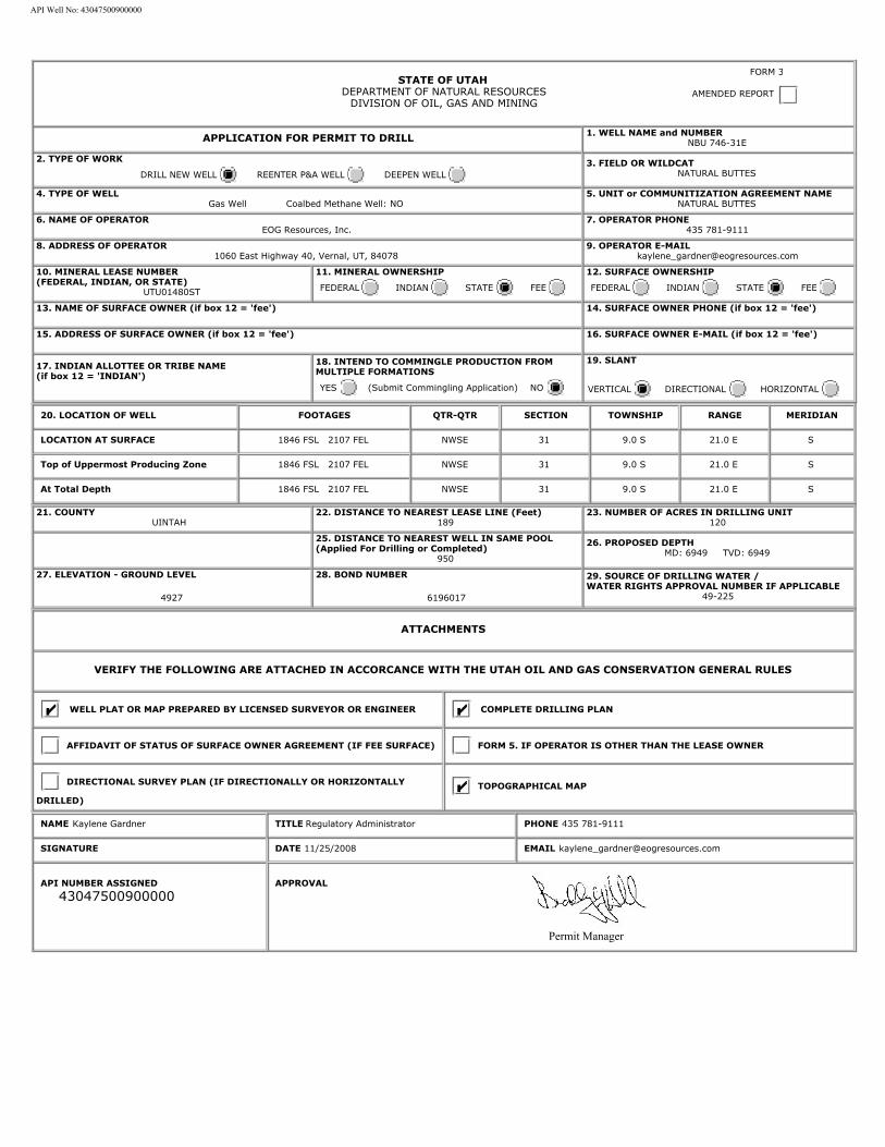
STATE OF UTAHDEPARTMENT OF NATURAL RESOURCES
DIVISION OF OIL, GAS AND MINING
APPLICATION FOR PERMIT TO DRILL 1. WELL NAME and NUMBER
NBU 746-31E
2. TYPE OF WORK
DRILL NEW WELL REENTER P&A WELL DEEPEN WELL 3. FIELD OR WILDCAT
NATURAL BUTTES
4. TYPE OF WELLGas Well Coalbed Methane Well: NO
5. UNIT or COMMUNITIZATION AGREEMENT NAMENATURAL BUTTES
6. NAME OF OPERATOREOG Resources, Inc.
7. OPERATOR PHONE435 781-9111
8. ADDRESS OF OPERATOR1060 East Highway 40, Vernal, UT, 84078
9. OPERATOR [email protected]
10. MINERAL LEASE NUMBER(FEDERAL, INDIAN, OR STATE)
UTU01480ST
11. MINERAL OWNERSHIP
FEDERAL INDIAN STATE FEE 12. SURFACE OWNERSHIP
FEDERAL INDIAN STATE FEE
13. NAME OF SURFACE OWNER (if box 12 = 'fee')
14. SURFACE OWNER PHONE (if box 12 = 'fee')
15. ADDRESS OF SURFACE OWNER (if box 12 = 'fee')
16. SURFACE OWNER E-MAIL (if box 12 = 'fee')
17. INDIAN ALLOTTEE OR TRIBE NAME(if box 12 = 'INDIAN')
18. INTEND TO COMMINGLE PRODUCTION FROMMULTIPLE FORMATIONS
YES (Submit Commingling Application) NO
19. SLANT
VERTICAL DIRECTIONAL HORIZONTAL
20. LOCATION OF WELL FOOTAGES QTR-QTR SECTION TOWNSHIP RANGE MERIDIAN
LOCATION AT SURFACE 1846 FSL 2107 FEL NWSE 31 9.0 S 21.0 E S
Top of Uppermost Producing Zone 1846 FSL 2107 FEL NWSE 31 9.0 S 21.0 E S
At Total Depth 1846 FSL 2107 FEL NWSE 31 9.0 S 21.0 E S
21. COUNTYUINTAH
22. DISTANCE TO NEAREST LEASE LINE (Feet)189
23. NUMBER OF ACRES IN DRILLING UNIT120
25. DISTANCE TO NEAREST WELL IN SAME POOL(Applied For Drilling or Completed)
950
26. PROPOSED DEPTHMD: 6949 TVD: 6949
27. ELEVATION - GROUND LEVEL
4927
28. BOND NUMBER
6196017
29. SOURCE OF DRILLING WATER /WATER RIGHTS APPROVAL NUMBER IF APPLICABLE
49-225
ATTACHMENTS
VERIFY THE FOLLOWING ARE ATTACHED IN ACCORCANCE WITH THE UTAH OIL AND GAS CONSERVATION GENERAL RULES
WELL PLAT OR MAP PREPARED BY LICENSED SURVEYOR OR ENGINEER COMPLETE DRILLING PLAN
AFFIDAVIT OF STATUS OF SURFACE OWNER AGREEMENT (IF FEE SURFACE) FORM 5. IF OPERATOR IS OTHER THAN THE LEASE OWNER
DIRECTIONAL SURVEY PLAN (IF DIRECTIONALLY OR HORIZONTALLY
DRILLED)
TOPOGRAPHICAL MAP
NAME Kaylene Gardner TITLE Regulatory Administrator PHONE 435 781-9111
SIGNATURE DATE 11/25/2008 EMAIL [email protected]
API NUMBER ASSIGNED
43047500900000
Permit Manager
APPROVAL
FORM 3
AMENDED REPORT
API Well No: 43047500900000
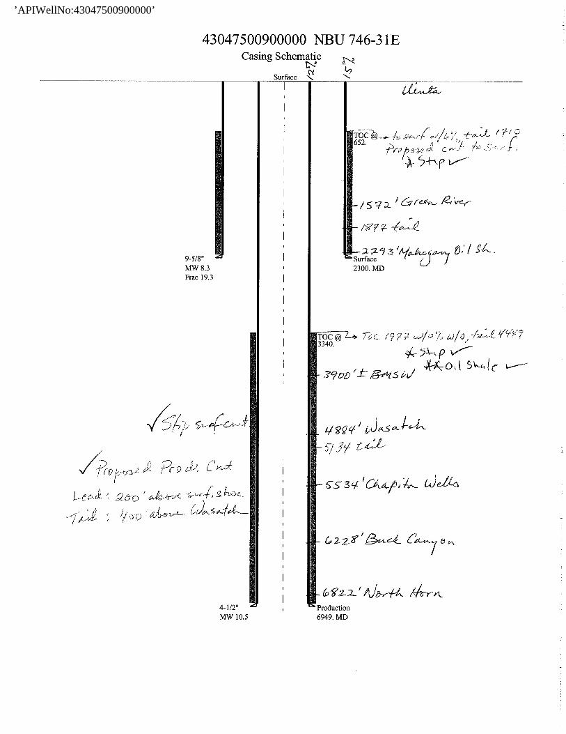
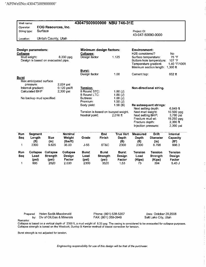
Proposed Hole, Casing, and Cement
String Hole Size Casing Size Top (MD) Bottom (MD)
Cond 17.5 13.375 0 60
Pipe Grade Length Weight
Grade H-40 ST&C 60 48.0
Cement Interval Top (MD) Bottom (MD)
0 60
Cement Description Class Sacks Yield Weight
Class G Cement 0 0.0 0.0
API Well No: 43047500900000

Proposed Hole, Casing, and Cement
String Hole Size Casing Size Top (MD) Bottom (MD)
Surf 12.25 9.875 0 2300
Pipe Grade Length Weight
Grade J-55 ST&C 2300 36.0
Cement Interval Top (MD) Bottom (MD)
0 2300
Cement Description Class Sacks Yield Weight
Class G Cement 185 3.82 11.0
API Well No: 43047500900000
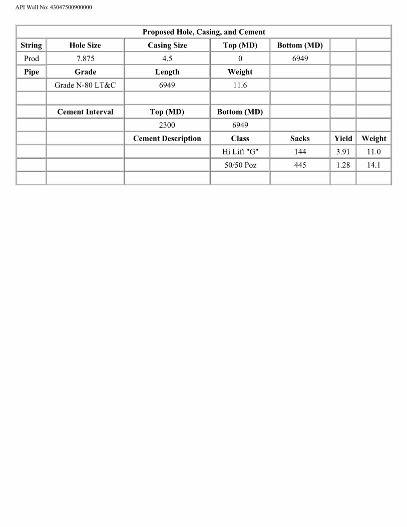
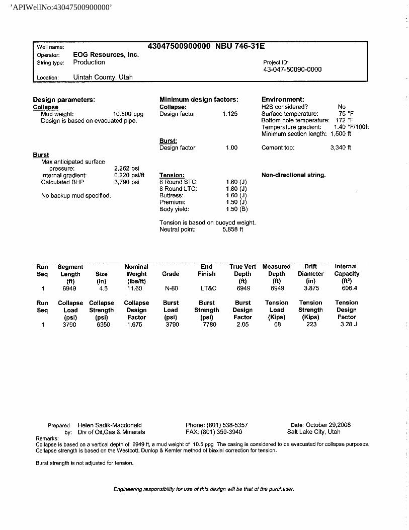
Proposed Hole, Casing, and Cement
String Hole Size Casing Size Top (MD) Bottom (MD)
Prod 7.875 4.5 0 6949
Pipe Grade Length Weight
Grade N-80 LT&C 6949 11.6
Cement Interval Top (MD) Bottom (MD)
2300 6949
Cement Description Class Sacks Yield Weight
Hi Lift "G" 144 3.91 11.0
50/50 Poz 445 1.28 14.1
API Well No: 43047500900000
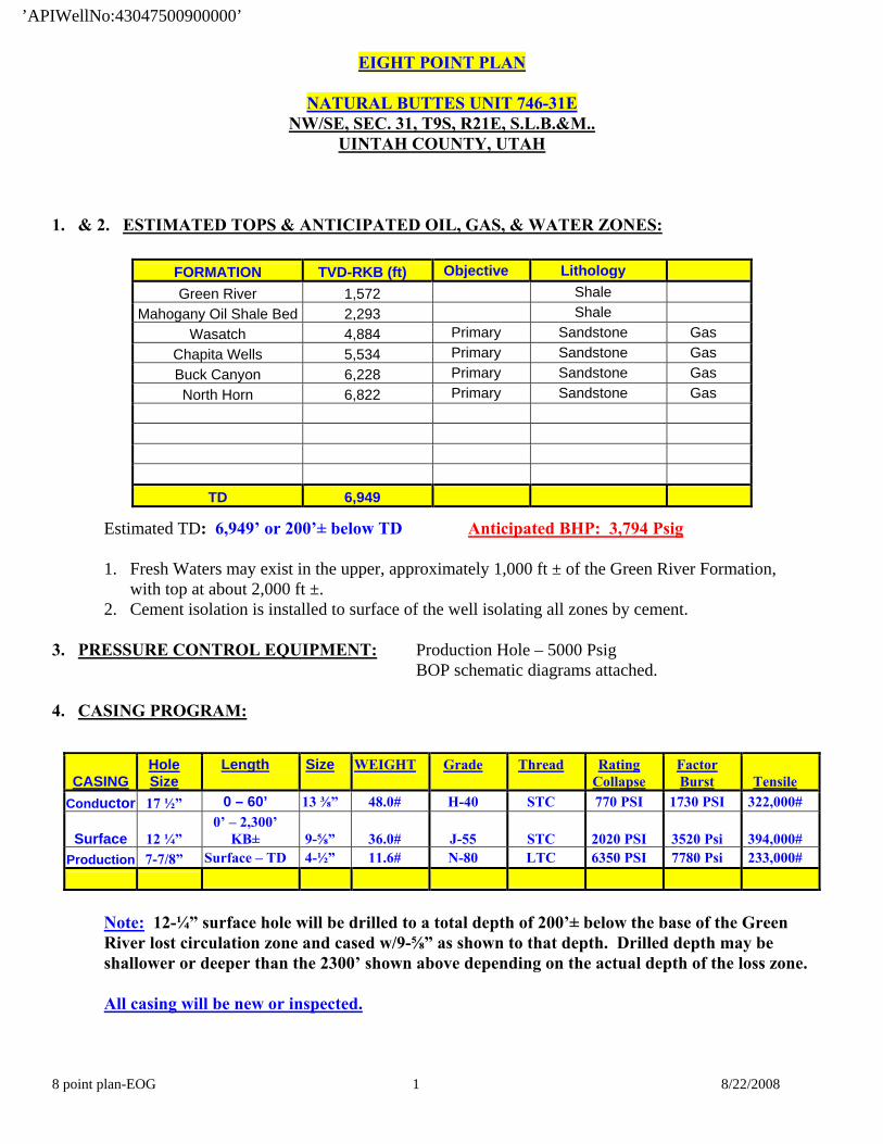
EIGHT POINT PLAN
NATURAL BUTTES UNIT 746-31E NW/SE, SEC. 31, T9S, R21E, S.L.B.&M..
UINTAH COUNTY, UTAH
8 point plan-EOG 1 8/22/2008
1. & 2. ESTIMATED TOPS & ANTICIPATED OIL, GAS, & WATER ZONES:
FORMATION TVD-RKB (ft) Objective Lithology Green River 1,572 Shale
Mahogany Oil Shale Bed 2,293 Shale Wasatch 4,884 Primary Sandstone Gas
Chapita Wells 5,534 Primary Sandstone Gas Buck Canyon 6,228 Primary Sandstone Gas North Horn 6,822 Primary Sandstone Gas
TD 6,949
Estimated TD: 6,949’ or 200’± below TD Anticipated BHP: 3,794 Psig
1. Fresh Waters may exist in the upper, approximately 1,000 ft ± of the Green River Formation, with top at about 2,000 ft ±.
2. Cement isolation is installed to surface of the well isolating all zones by cement. 3. PRESSURE CONTROL EQUIPMENT: Production Hole – 5000 Psig BOP schematic diagrams attached. 4. CASING PROGRAM:
Note: 12-¼” surface hole will be drilled to a total depth of 200’± below the base of the Green River lost circulation zone and cased w/9-⅝” as shown to that depth. Drilled depth may be shallower or deeper than the 2300’ shown above depending on the actual depth of the loss zone. All casing will be new or inspected.
CASINGHole Size
Length Size WEIGHT Grade Thread Rating Collapse
Factor Burst
Tensile
Conductor 17 ½” 0 – 60’ 13 ⅜” 48.0# H-40 STC 770 PSI 1730 PSI 322,000#
Surface 12 ¼” 0’ – 2,300’
KB±
9-⅝”
36.0#
J-55
STC
2020 PSI
3520 Psi
394,000# Production 7-7/8” Surface – TD 4-½” 11.6# N-80 LTC 6350 PSI 7780 Psi 233,000#
’APIWellNo:43047500900000’
EIGHT POINT PLAN
NATURAL BUTTES UNIT 746-31E NW/SE, SEC. 31, T9S, R21E, S.L.B.&M..
UINTAH COUNTY, UTAH
8 point plan-EOG 2 8/22/2008
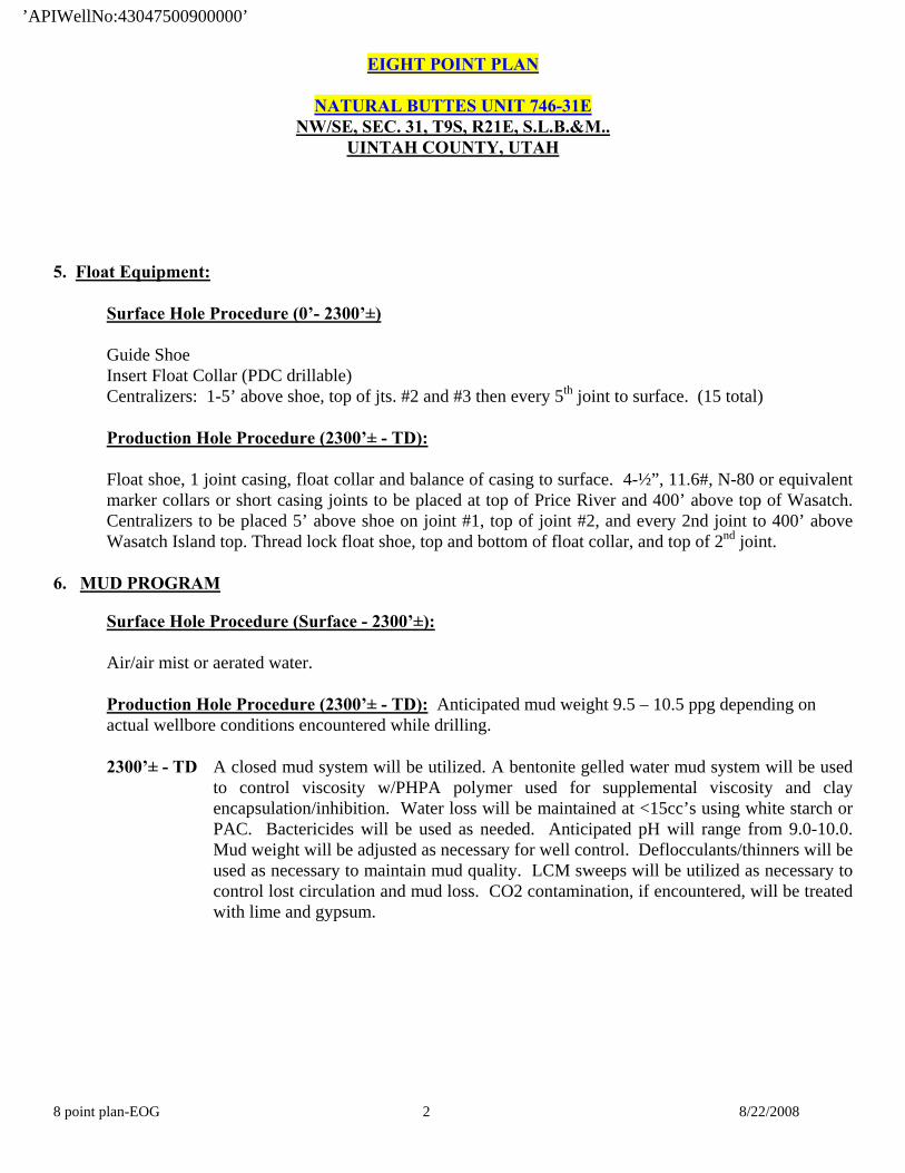
5. Float Equipment:
Surface Hole Procedure (0’- 2300’±)
Guide Shoe Insert Float Collar (PDC drillable)
Centralizers: 1-5’ above shoe, top of jts. #2 and #3 then every 5th joint to surface. (15 total)
Production Hole Procedure (2300’± - TD): Float shoe, 1 joint casing, float collar and balance of casing to surface. 4-½”, 11.6#, N-80 or equivalent marker collars or short casing joints to be placed at top of Price River and 400’ above top of Wasatch. Centralizers to be placed 5’ above shoe on joint #1, top of joint #2, and every 2nd joint to 400’ above Wasatch Island top. Thread lock float shoe, top and bottom of float collar, and top of 2nd joint.
6. MUD PROGRAM Surface Hole Procedure (Surface - 2300’±):
Air/air mist or aerated water.
Production Hole Procedure (2300’± - TD): Anticipated mud weight 9.5 – 10.5 ppg depending on actual wellbore conditions encountered while drilling. 2300’± - TD A closed mud system will be utilized. A bentonite gelled water mud system will be used
to control viscosity w/PHPA polymer used for supplemental viscosity and clay encapsulation/inhibition. Water loss will be maintained at <15cc’s using white starch or PAC. Bactericides will be used as needed. Anticipated pH will range from 9.0-10.0. Mud weight will be adjusted as necessary for well control. Deflocculants/thinners will be used as necessary to maintain mud quality. LCM sweeps will be utilized as necessary to control lost circulation and mud loss. CO2 contamination, if encountered, will be treated with lime and gypsum.
’APIWellNo:43047500900000’
EIGHT POINT PLAN
NATURAL BUTTES UNIT 746-31E NW/SE, SEC. 31, T9S, R21E, S.L.B.&M..
UINTAH COUNTY, UTAH
8 point plan-EOG 3 8/22/2008
1. VARIANCE REQUESTS:
Reference: Onshore Oil and Gas Order No. 1 Onshore Oil and Gas Order No. 2 – Section E: Special Drilling Operations
o EOG Resources, Inc. requests a variance to regulations requiring a straight run blooie line to be
100’ in length. (Where possible, a straight run blooie line will be used).
o EOG Resources, Inc. requests a variance to regulations requiring the blooie line to be 100’ in length. To reduce location excavation, the blooie line will be approximately 75’ in length.
o EOG Resources, Inc. requests a variance to regulations, during air drilling operations only,
requiring dedusting equipment. Dust during air drilling operations is controlled by water mist. o EOG Resources, Inc. requests a variance to regulations, during air drilling operations only,
requiring an automatic igniter or continuous pilot light on the blooie line. (Not required on aerated water system).
o EOG Resources, Inc. requests a variance that compressors are located in the opposite direction
from the blooie line a minimum of 100 feet from the well bore. (Air Compressors are rig mounted).
8. EVALUATION PROGRAM:
Logs: Mud log from base of surface casing to TD. Cased-hole Logs: Cased-hole logs will be run in lieu of open-hole logs consisting of the following:
Cement Bond / Casing Collar Locator and Pulsed Neutron
’APIWellNo:43047500900000’
EIGHT POINT PLAN
NATURAL BUTTES UNIT 746-31E NW/SE, SEC. 31, T9S, R21E, S.L.B.&M..
UINTAH COUNTY, UTAH
8 point plan-EOG 4 8/22/2008
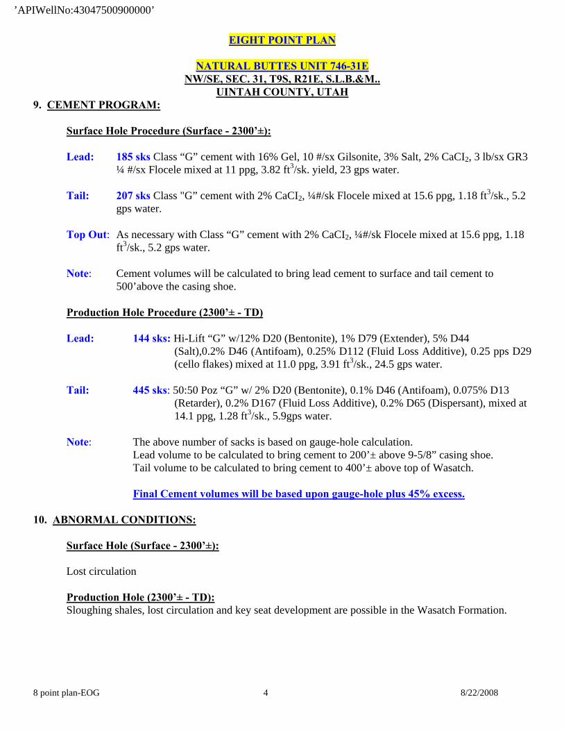
9. CEMENT PROGRAM: Surface Hole Procedure (Surface - 2300’±):
Lead: 185 sks Class “G” cement with 16% Gel, 10 #/sx Gilsonite, 3% Salt, 2% CaCI2, 3 lb/sx GR3 ¼ #/sx Flocele mixed at 11 ppg, 3.82 ft3/sk. yield, 23 gps water.
Tail: 207 sks Class "G” cement with 2% CaCI2, ¼#/sk Flocele mixed at 15.6 ppg, 1.18 ft3/sk., 5.2
gps water.
Top Out: As necessary with Class “G” cement with 2% CaCI2, ¼#/sk Flocele mixed at 15.6 ppg, 1.18 ft3/sk., 5.2 gps water.
Note: Cement volumes will be calculated to bring lead cement to surface and tail cement to
500’above the casing shoe. Production Hole Procedure (2300’± - TD) Lead: 144 sks: Hi-Lift “G” w/12% D20 (Bentonite), 1% D79 (Extender), 5% D44
(Salt),0.2% D46 (Antifoam), 0.25% D112 (Fluid Loss Additive), 0.25 pps D29 (cello flakes) mixed at 11.0 ppg, 3.91 ft3/sk., 24.5 gps water.
Tail: 445 sks: 50:50 Poz “G” w/ 2% D20 (Bentonite), 0.1% D46 (Antifoam), 0.075% D13 (Retarder), 0.2% D167 (Fluid Loss Additive), 0.2% D65 (Dispersant), mixed at 14.1 ppg, 1.28 ft3/sk., 5.9gps water.
Note: The above number of sacks is based on gauge-hole calculation.
Lead volume to be calculated to bring cement to 200’± above 9-5/8” casing shoe. Tail volume to be calculated to bring cement to 400’± above top of Wasatch. Final Cement volumes will be based upon gauge-hole plus 45% excess.
10. ABNORMAL CONDITIONS:
Surface Hole (Surface - 2300’±):
Lost circulation Production Hole (2300’± - TD): Sloughing shales, lost circulation and key seat development are possible in the Wasatch Formation.
’APIWellNo:43047500900000’
EIGHT POINT PLAN
NATURAL BUTTES UNIT 746-31E NW/SE, SEC. 31, T9S, R21E, S.L.B.&M..
UINTAH COUNTY, UTAH
8 point plan-EOG 5 8/22/2008
11. STANDARD REQUIRED EQUIPMENT:
A. Choke Manifold B. Upper and Lower Kelly Cock C. Stabbing Valve D. Visual Mud Monitoring
12. HAZARDOUS CHEMICALS:
No chemicals subject to reporting under SARA title III in an amount equal to or greater than 10,000 pounds will be used, produced, stored, transported, or disposed of annually in association with the drilling of this well. Furthermore, no extremely hazardous substances, as defined in 40 CFR 355, in threshold planning quantities, will be used, produced, stored, transported, or disposed of in association with the drilling of this well.
13. Air Drilling Operations:
1. Main Air Compressors are 1250 CFM 350 psi with 2000 psi Boosters and are rig mounted.
2. Secondary Air Compressors are 1170 CFM 350 psi with 2000 psi Boosters and are rig mounted.
3. Minimum setting depth of conductor casing will be 60’ GL or 10’± into competent formation, whichever is deeper, as determined by the EOG person in charge. Exceptions must be approved by an EOG drilling superintendent or manager.
4. The diameter of the diverter flow line will be a minimum of 10” to help reduce back pressure on the
well bore during uncontrolled flow.
5. Rat and Mouse hole drilling will occur only after surface casing has been set and cemented.
6. EOG Resources, Inc. will use a properly maintained and lubricated stripper head.
(Attachment: BOP Schematic Diagram)
’APIWellNo:43047500900000’

’APIWellNo:43047500900000’

’APIWellNo:43047500900000’
’APIWellNo:43047500900000’
’APIWellNo:43047500900000’
’APIWellNo:43047500900000’
’APIWellNo:43047500900000’

’APIWellNo:43047500900000’
’APIWellNo:43047500900000’

’APIWellNo:43047500900000’
’APIWellNo:43047500900000’

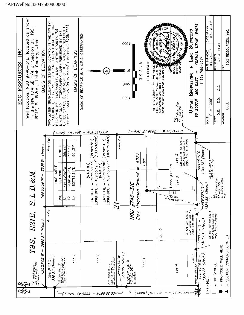
Natural Buttes Unit 746-31E NWSE, Section 31, T9S, R21E
Uintah County, Utah
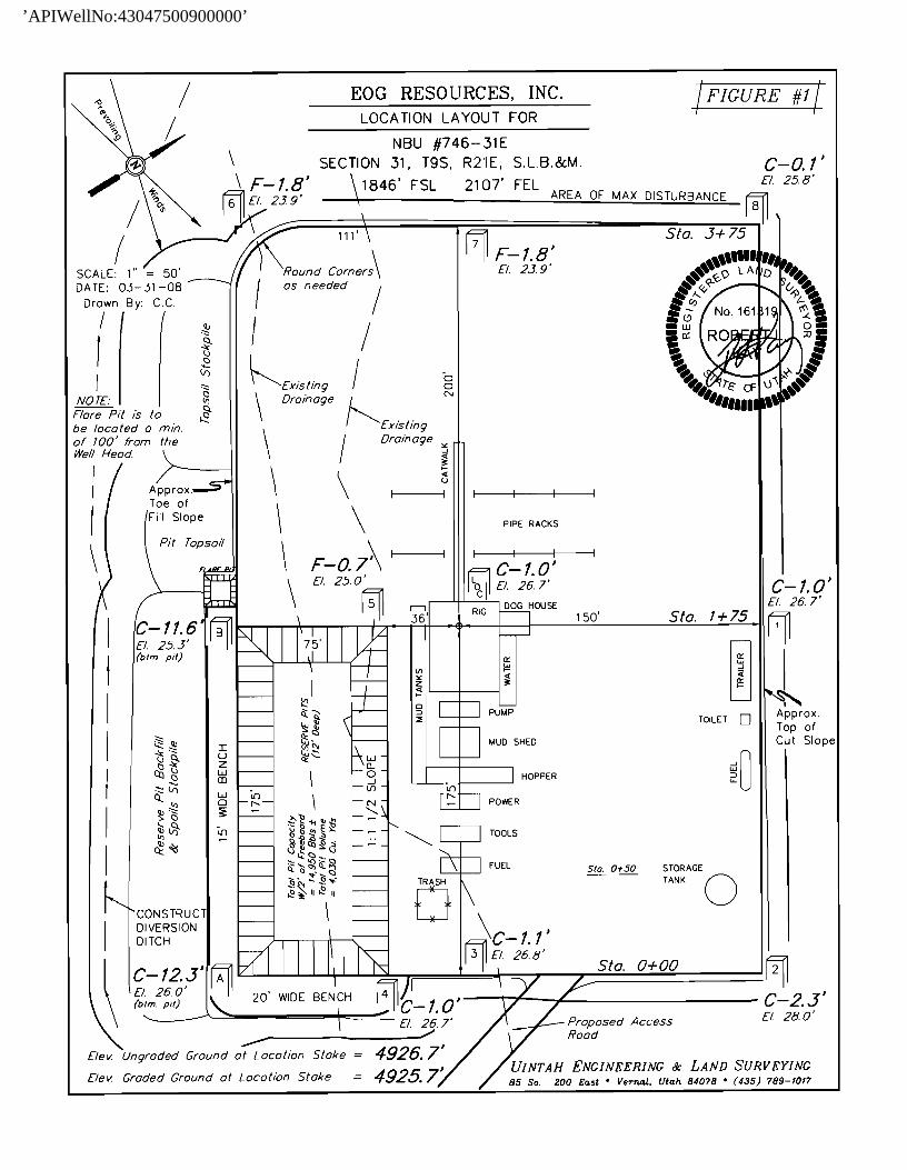
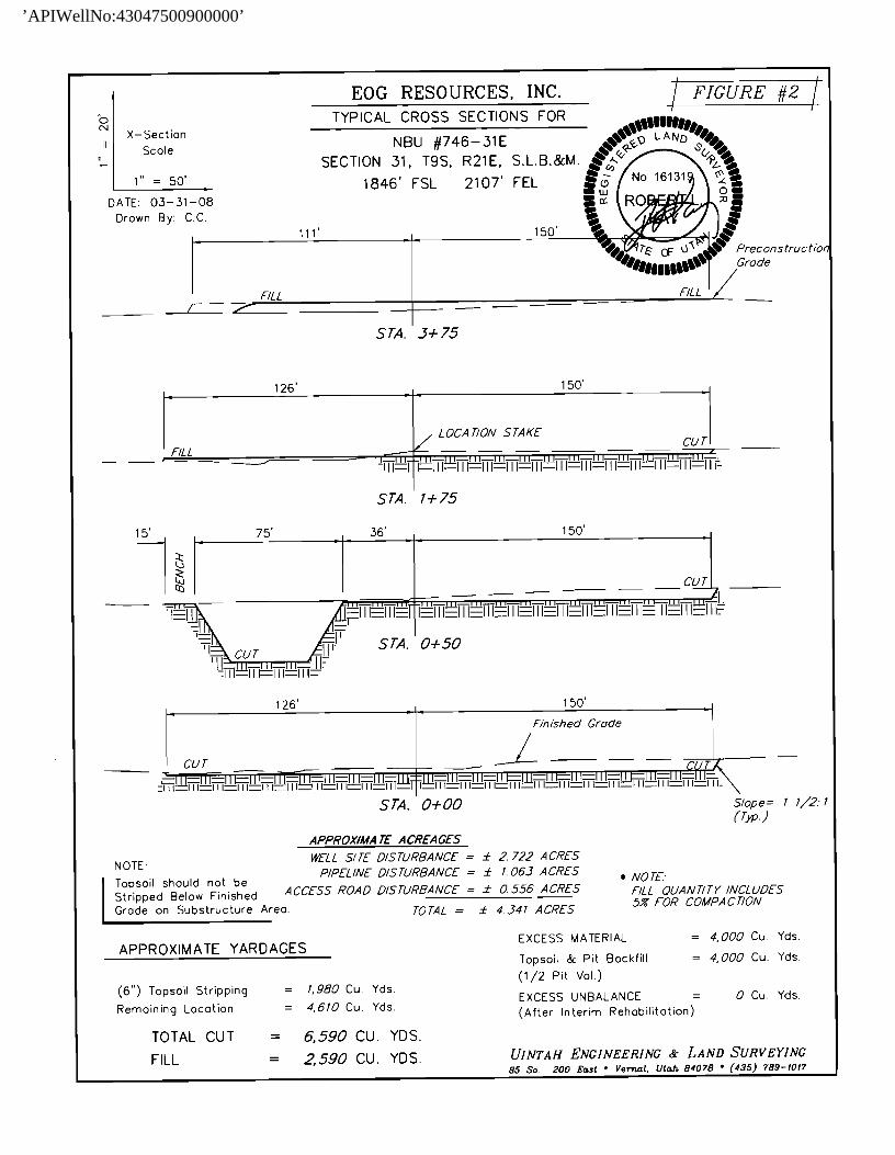
SURFACE USE PLAN The well pad is approximately 375 feet long with a 261-foot width, containing 2.25 acres more or less. The well access road is approximately 792 feet long with a 30-foot right-of-way, disturbing approximately 0.55 acre. New surface disturbance associated with the well pad and access road is estimated to be 2.80 acres. The pipeline is approximately 1544 feet long with a 40-foot temporary right-of-way and a 8-foot permanent right-of-way disturbing approximately 0.28 acre. 1. EXISTING ROADS:
A. See attached Plats showing directional reference stakes on location, and attached TOPO Map “B” showing access to location from existing roads.
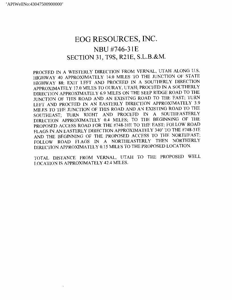
B. The proposed well site is located approximately 42.4 miles south of Vernal, Utah –
See attached TOPO Map “A”.
C. Refer to attached Topographic Map “A” showing labeled access route to location.
D. Existing roads will be maintained and repaired as necessary. 2. PLANNED ACCESS ROAD:
A. The access road will be approximately 792’ in length. Culvert’s and low water crossings shall be installed as needed. See attached Topo B.
B. The access road has a 30-foot ROW w/18 foot running surface.
C. Maximum grade of the new access road will be 8 percent.
D. No turnouts will be required.
E. Road drainage crossings shall be of the typical dry creek drainage crossing type.
F. No bridges, or major cuts and fills will be required.
G. The access road will be dirt surface.
H. No gates, cattleguards, or fences will be required or encountered.
’APIWellNo:43047500900000’

NATURAL BUTTES UNIT 746-31E Surface Use Plan Page 2
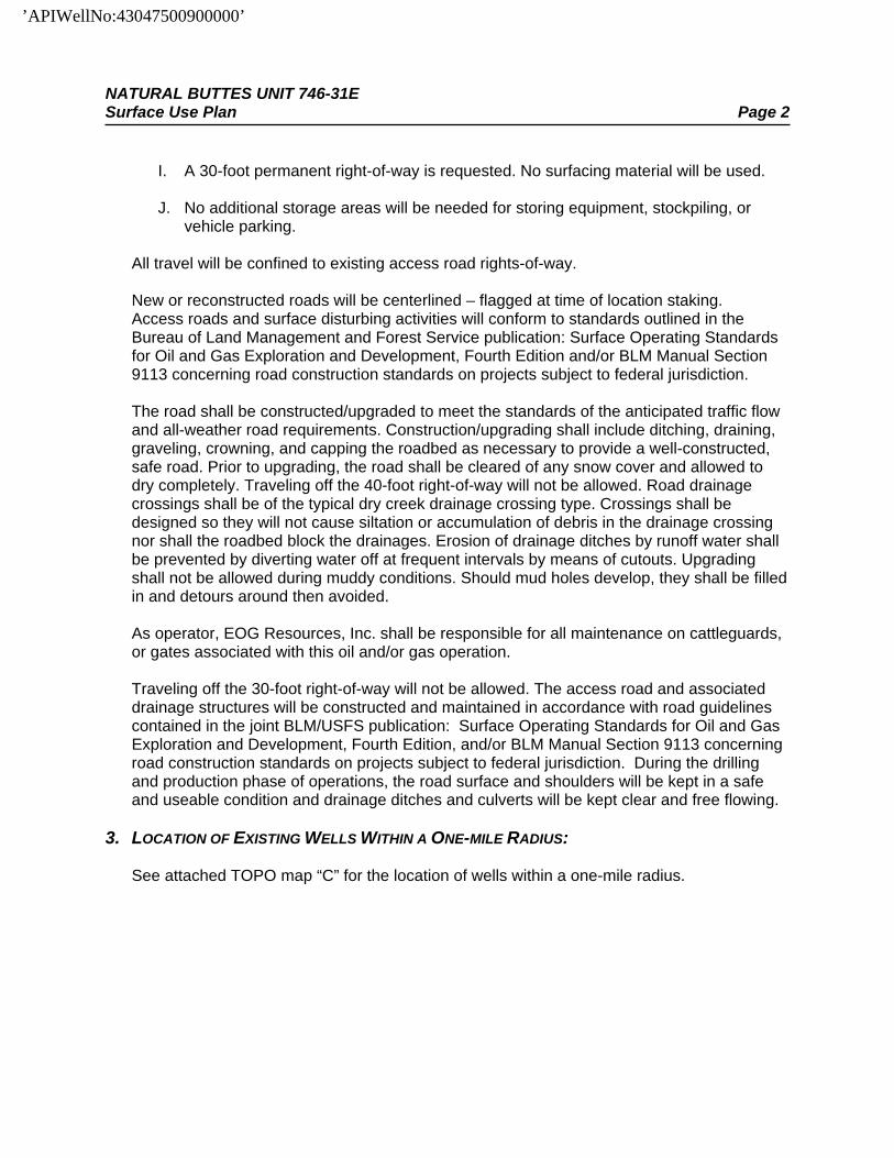
I. A 30-foot permanent right-of-way is requested. No surfacing material will be used.
J. No additional storage areas will be needed for storing equipment, stockpiling, or vehicle parking.
All travel will be confined to existing access road rights-of-way. New or reconstructed roads will be centerlined – flagged at time of location staking. Access roads and surface disturbing activities will conform to standards outlined in the Bureau of Land Management and Forest Service publication: Surface Operating Standards for Oil and Gas Exploration and Development, Fourth Edition and/or BLM Manual Section 9113 concerning road construction standards on projects subject to federal jurisdiction. The road shall be constructed/upgraded to meet the standards of the anticipated traffic flow and all-weather road requirements. Construction/upgrading shall include ditching, draining, graveling, crowning, and capping the roadbed as necessary to provide a well-constructed, safe road. Prior to upgrading, the road shall be cleared of any snow cover and allowed to dry completely. Traveling off the 40-foot right-of-way will not be allowed. Road drainage crossings shall be of the typical dry creek drainage crossing type. Crossings shall be designed so they will not cause siltation or accumulation of debris in the drainage crossing nor shall the roadbed block the drainages. Erosion of drainage ditches by runoff water shall be prevented by diverting water off at frequent intervals by means of cutouts. Upgrading shall not be allowed during muddy conditions. Should mud holes develop, they shall be filled in and detours around then avoided. As operator, EOG Resources, Inc. shall be responsible for all maintenance on cattleguards, or gates associated with this oil and/or gas operation. Traveling off the 30-foot right-of-way will not be allowed. The access road and associated drainage structures will be constructed and maintained in accordance with road guidelines contained in the joint BLM/USFS publication: Surface Operating Standards for Oil and Gas Exploration and Development, Fourth Edition, and/or BLM Manual Section 9113 concerning road construction standards on projects subject to federal jurisdiction. During the drilling and production phase of operations, the road surface and shoulders will be kept in a safe and useable condition and drainage ditches and culverts will be kept clear and free flowing.
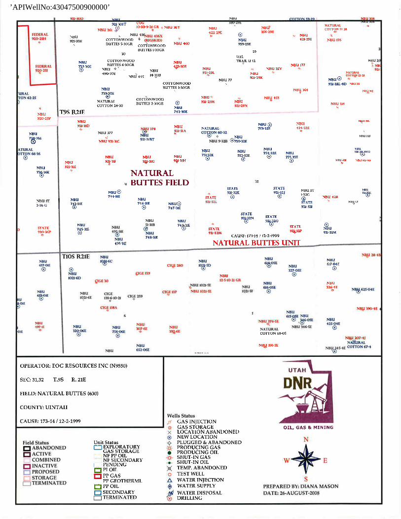
3. LOCATION OF EXISTING WELLS WITHIN A ONE-MILE RADIUS:
See attached TOPO map “C” for the location of wells within a one-mile radius.
’APIWellNo:43047500900000’
NATURAL BUTTES UNIT 746-31E Surface Use Plan Page 3 4. LOCATION OF EXISTING AND/OR PROPOSED PRODUCTION FACILITIES:
A. On Well Pad
1. Production facilities will be set on location if the well is successfully completed for production. Facilities will consist of wellhead valves, combo separator-dehy unit with meter, one (1) 300-bbl tank and/or two (2) 400-bbl vertical tanks and attaching piping.
2. Gas gathering lines – A 4” gathering line will be buried from dehy to the edge of the location.
B. Off Well Pad
1. Proposed pipeline will transport natural gas. 2. The pipeline will be a permanent feeder line. 3. The length of the proposed pipeline is 1544’ x 40’ temporary, 1544 x 8’
permanent. The proposed pipeline leaves the western edge of the well pad (Lease UTU01480) proceeding in a southerly direction for an approximate distance of 1544’ tieing into an existing pipeline in the NWSE of Section 31, T9S, R21E. Pipe will be 4” NOM, 0.156 wall, Grade X42, Zap-Lock, electric weld with a 35 mil X-Tru coating.
4. Proposed pipeline will be a 4” OD steel, zap-lok line laid on the surface
5. Proposed pipeline will be laid on surface.
6. Pipeline will be coupled using the Zap lock method. No additional off-pad
facilities will be required.
All permanent (on site for six months or longer) structures constructed or installed (including pumping units) will be painted a flat, non-reflective, earthtone color to match one of the standard environmental colors, as determined by the Rocky Mountain Five State Interagency Committee. All facilities will be painted within 6 months of installation. All facilities will be painted with Carlsbad Canyon. Facilities required to comply with O.S.H.A. (Occupational Safety and Health Act) will be excluded.
5. LOCATION AND TYPE OF WATER SUPPLY:
A. Water supply will be Bonanza Power Plant water source in Sec 26, T8S, R23E, Uintah County, UT (State Water Right # 49-225(A31368)). Water will be hauled by a licensed trucking company.
B. Water will be hauled by a licensed trucking company.
’APIWellNo:43047500900000’
NATURAL BUTTES UNIT 746-31E Surface Use Plan Page 4
C. No water well will be drilled on lease.
6. SOURCE OF CONSTRUCTION MATERIALS:
A. All construction material for this pipeline will be of native borrow and soil accumulated during the construction of the location.
B. No mineral materials will be required.
7. METHODS OF HANDLING WASTE DISPOSAL:
A. METHODS AND LOCATION
1. Cuttings will be confined in the reserve pit. 2. A portable toilet will be provided for human waste during the drilling and
completion of the well. Disposal will be at the Vernal sewage disposal plant. 3. Burning will not be allowed. Trash and other waste material will be contained in a
wire mesh cage and disposed of at the Uintah County Landfill. 4. Produced wastewater will be confined to a lined pit or storage tank for a period
not to exceed 90 days after initial production. After the 90 day period, the produced water will be contained in a tank on location and then disposed of at one of the following locations: Natural Buttes Unit 21-20B SWD, Ace Disposal, CWU 550-30N SWD, CWU 2-29 SWD, Red Wash Evaporation ponds 1, 2, 3, 4, 5 or 6, Coyote Evaporation Ponds, or EOG Resources, Inc. drilling operations (Chapita Wells Unit, Natural Buttes Unit & Stagecoach Unit).
5. All chemicals will be disposed of at an authorized disposal site. Drip pans and
absorbent pads will be used on the drilling rig to avoid leakage of oil to the pit.
B. Water from drilling fluids and recovered during testing operations will be disposed of by either evaporating in the reserve pit, through natural or artificial methods, or removed and disposed of at an authorized disposal site. Introduction of well bore hydrocarbons to the reserve pit will be avoided by flaring them off in the flare pit at the time of recovery.
The reserve pit will be constructed so as not to leak, break, or allow discharge. If the reserve pit requires padding prior to lining (due to rocky conditions) felt padding will be used.
The reserve pit shall be lined with felt, and a 20-millimeter plastic liner. Sufficient bedding (i.e. weed free straw, or hay; felt; polyswell or soil) will be used to cover any rocks. The liner will overlap the pit walls and be covered with dirt and/or rocks to hold it in place. No trash, scrap pipe, etc., that could puncture the liner will be disposed of in the pit. More stringent protective requirements may be deemed necessary by the A.O.
’APIWellNo:43047500900000’

NATURAL BUTTES UNIT 746-31E Surface Use Plan Page 5
EOG Resources, Inc. maintains a file, per 29 CFR 1910.1200 (g) containing current Material Safety Data Sheets (MSDS) for all chemicals, compounds, and/or substances which are used during the course of construction, drilling, completion, and production operations for this project. Hazardous materials (substances) which may be found at the site may include drilling mud and cementing products which are primarily inhalation hazards, fuels (flammable and/or combustible), materials that may be necessary for well completion/ stimulation activities such as flammable or combustible substances and acids/gels (corrosives). The opportunity for Superfund Amendments and Reauthorization Act (SARA) listed Extremely Hazardous Substances (EHS) at the site is generally limited to proprietary treating chemicals. All hazardous and EHS and commercial preparations will be handled in an appropriate manner to minimize the potential for leaks or spills to the environment. No chemicals subject to reporting under SARA Title III (hazardous materials) in an amount greater than 10,000 pounds will be used, produced, stored, transported, or disposed of annually in association with the drilling, testing, or completion of the well. Furthermore, extremely hazardous substances, as defined in 40 CFR 355, in threshold planning quantities, will not be used, produced, stored, transported, or disposed of in association with the drilling, testing or completion of the well.
8. ANCILLARY FACILITIES:
None anticipated.
9. WELL SITE LAYOUT:
A. Refer to attached well site plat for related topography cuts and fills and cross sections.
B. Refer to attached well site plat for rig layout and soil material stockpile location as
approved on On-site.
C. Refer to attached well site plat for rig orientation, parking areas, and access road. The reserve pit will be located on the southeast corner of the location. The flare pit will be located downwind of the prevailing wind direction on the south side of the location, a minimum of 100 feet from the wellhead and 30 feet from the reserve pit fence. The stockpiled pit topsoil (first six inches) will be stored separate from the location. The stockpiled location topsoil will be stored in a location providing easy access for interim reclamation and protection of the topsoil. Upon completion of construction, the stockpiled topsoil from the location will be broadcast seeded with the approved seed mixture from this location and then walked down with a Caterpillar tractor. Access to the well pad will be from the east. FENCING REQUIREMENTS:
’APIWellNo:43047500900000’

NATURAL BUTTES UNIT 746-31E Surface Use Plan Page 6
All pits will be fenced according to the following minimum standards:
A. Thirty-nine inch net wire shall be used with at least one strand of barbed wire on top of the net wire. (Barbed wire is not necessary if pipe or some type of reinforcement rod is attached to the top of the entire fence.)
B. The net wire shall be no more than 2 inches above the ground. The barbed wire
strand shall be 3 inches above the net wire. Total height of the fence shall be at least 42 inches.
C. Corner posts shall be cemented and/or braced in such a manner as to keep the
fence tight at all times.
D. Standard steel, wood, or pipe posts shall be used between the corner braces. Maximum distances between any two posts shall be no greater than 16 feet.
E. All wire shall be stretched by using a stretching device before it is attached to the
corner posts.
The reserve pit fencing will be on the three sides during drilling operations and on the fourth side when the rig moves off location. Pits will be fenced and maintained until clean-up. Each existing fence to be crossed by the access road shall be braced and tied off before cutting so as to prevent slacking of the wire. The opening shall be closed temporarily as necessary during construction to prevent the escape of livestock, and, upon completion of construction, the fence shall be repaired to BLM or SMA specifications. A cattleguard with an adjacent 16 foot gate shall be installed in any fence where a road is regularly traveled. If the well is a producer, the cattleguards (shall/shall not) be permanently counted on concrete bases. Prior to crossing any fence located on Federal land, or any fence between Federal land and private land, the operator will contact the BLM, who will in turn contact the grazing permittee or owner of said fence and offer him/her the opportunity to be present when the fence is cut in order to satisfy himself/herself that the fence is adequately braced and tied off.
10. PLANS FOR RECLAMATION OF THE SURFACE:
A. Interim Reclamation (Producing Location) Immediately upon well completion, the location and surrounding area will be cleared of all unused tubing, equipment, debris, materials, trash, and junk not required for production. Immediately upon well completion, any hydrocarbons on the pit shall be removed in accordance with CFR 3162.7-1.
’APIWellNo:43047500900000’
NATURAL BUTTES UNIT 746-31E Surface Use Plan Page 7
If a plastic nylon reinforced liner is used, it shall be torn and perforated before backfilling of the reserve pit. The reserve pit and that portion of the location not needed for production facilities/operations will be recontoured to the approximate natural contours. The reserve pit will be reclaimed within 90 days from the date of the well completion, or as soon as environmental conditions allow. Before any dirt takes place, the reserve pit must be completely dry and free of all foreign obstacles. The stockpiled pit topsoil will then be spread over the pit area and broadcast seeded with the prescribed seed mixture for this location. The seeded area will then be walked down with a cat.
B. Dry Hole/Abandoned Location
At such time as the well is plugged and abandoned, the operator will submit a subsequent report of abandonment and the BLM will attach the appropriated surface rehabilitation conditions of approval.
*Pure live seed (PLS) formula: percent of purity of seed mixture times percent germination of seed mixture equals portion of seed mixture that is PLS.
11. SURFACE OWNERSHIP:
Surface ownership of the proposed well site, access road, and pipeline route is as follows:
State of Utah
12. OTHER INFORMATION:
A. EOG Resources, Inc. will inform all persons in the area who are associated with this project that they are subject to prosecution for knowingly disturbing historic or archaeological sites, or for collecting artifacts. If historic or archaeological materials are uncovered during construction, the operator will immediately stop work that might further disturb such materials, and contact the Authorized Officer. Within five working days the Authorized Officer will inform the operator as to:
• Whether the materials appear eligible for the National Register of Historic
Places; • The mitigation measures the operator will likely have to undertake before the
site can be used.
• A time frame for the Authorized Officer to complete an expedited review under 36 CFR 800.11 to confirm, through the State Historic Preservation Officer, that the findings of the Authorized Officer are correct and that mitigation is appropriate.
’APIWellNo:43047500900000’

NATURAL BUTTES UNIT 746-31E Surface Use Plan Page 8
If the operator wished, at any time, to relocate activities to avoid the expense of mitigation and/or the delays associated with this process, the Authorized Officer will assume responsibility for whatever recordation and stabilization of the exposed materials that may be required. Otherwise, the operator will be responsible for mitigation costs. The Authorized Officer will provide technical and procedural guidelines for the conduct of mitigation. Upon verification from the Authorized Officer that required mitigation has been completed, the operator will then be allowed to resume construction.
B. As operator, EOG Resources, Inc. will control noxious weeds along Right-of-Ways
for roads, pipelines, well sites, or other applicable facilities. A list of noxious weeds will be obtained from the BLM administered land, a Pesticide Use proposal shall be submitted, and given approval, prior to the application or herbicides or other pesticides or possible hazardous chemicals.
C. Drilling rigs and/or equipment used during drilling operations on this well site will not
be stacked or stored on BLM lands after the conclusion of drilling operations or at any other time without BLM authorization. However, if BLM authorization is obtained, it is only a temporary measure to allow time to make arrangements for permanent storage on commercial facilities. (The BLM does not seek to compete with private industry. There are commercial facilities available for stacking and storing drilling rigs.)
D. The drilling rig and ancillary equipment will be removed from the location prior to
commencement of completion operations. Completion operations will be conducted utilizing a completion/workover rig.
All lease and/or unit operations will be conducted in such a manner that full compliance is made with all applicable laws, regulations, Onshore Oil and Gas Orders, the approved Plan of Operations, and any applicable Notice of Lessees. The operator is fully responsible for the actions of its subcontractors. A complete copy of the approved “Application for Permit to Drill” will be furnished to the field representative(s) to ensure compliance and shall be on location during all construction and drilling operations. Construction activity will not be conducted using frozen or saturated soils material or during periods when watershed damage is likely to occur. If the existing access road, proposed access road, and proposed pad are dry during construction, drilling, and completion activities, water will be applied to help facilitate compaction during construction and to minimize soil loss as a result of wind erosion. A cultural resources survey was conducted and will be submitted by Montgomery Archaeological Consultants. A paleontological survey was conducted and will be submitted by Intermountain Paleo. Additional Surface Stipulations: None
’APIWellNo:43047500900000’
NATURAL BUTTES UNIT 746-31E Surface Use Plan Page 9
LESSEE OR OPERATOR’S REPRESENTATIVE AND CERTIFICATION: PERMITTING AGENT Kaylene R. Gardner EOG Resources, Inc. 1060 East Highway 40 Vernal, UT 84078 (435) 781-9111 All lease and/or unit operations will be conducted in such a manner that full compliance is made with all applicable laws, regulations, Onshore Oil and Gas Orders, the approved plan of operations, and any applicable Notice to Lessees. The operator is fully responsible for the actions of his subcontractors. A copy of these conditions will be furnished to the field representative to insure compliance. The operator or his/her contractor shall contact the BLM office at (435) 781-4400 forty-eight (48) hours prior to construction activities.
’APIWellNo:43047500900000’

NATURAL BUTTES UNIT 746-31E Surface Use Plan Page 10
CERTIFICATION: I hereby certify that I, or persons under my direct supervision, have inspected the proposed drill site and access route; that I am familiar with the conditions which currently exist; that the statements made in this plan are, to the best of my knowledge, true and correct; and that the work associated with the operations proposed herein will be performed by EOG Resources, Inc. and its contractors and subcontractors in conformity with this plan and the terms and conditions under which it is approved. This statement is subject to the provisions of 18 U.S.C. 1001 for the filing of a false statement. Please be advised that EOG Resources, Inc. is considered to be the operator of the Natural Buttes Unit 746-31E Well, located in the NWSE, of Section 31, T9S, R21E, Uintah County, Utah; Federal land and minerals; and is responsible under the terms and conditions of the lease for the operations conducted upon the leased lands. Bond Coverage is under Bond # NM 2308. August 22, 2008 Date Kaylene R. Gardner, Regulatory Administrator
’APIWellNo:43047500900000’

11" 5kR-54
11" 5kR-54
11" 5kR-54
13-3/8"
9-5/8"
PIPE RAMS
BLIND RAMS
ANNULARPREVENTER
ROTATINGHEAD
FMC “DTO” 9-5/8"SOW X 5,000 W.P.
FMC DRILLINGCONNECTOR, 11"5,000 X DTO PREP
EOG RESOURCES 11" 5,000 PSI W.P. BOPCONFIGURATION PAGE 1 OF 2
4-1/16" 5,000HCR VALVE
4-1/16" 5,000MANUAL VALVE 2-1/16" 5,000
MANUAL VALVES2-1/16" 5,000
CHECK VALVE
4" 5,000 PSICHOKE LINETO MANIFOLD
’APIWellNo:43047500900000’
HYD.CHOKE
3" MIN. ID TOSEPARATOR, OR PIT
3" MIN. ID TOSEPARATOR, OR PIT
3" MIN. ID BLEEDLINE TO PIT
4" 5,000 PSI CHOKELINE FROM HCR
VALVE
MANUALCHOKE
ADJUSTABLE
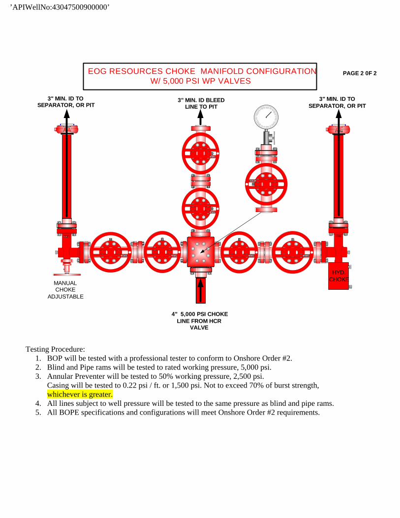
EOG RESOURCES CHOKE MANIFOLD CONFIGURATIONW/ 5,000 PSI WP VALVES
PAGE 2 0F 2
Testing Procedure: 1. BOP will be tested with a professional tester to conform to Onshore Order #2. 2. Blind and Pipe rams will be tested to rated working pressure, 5,000 psi. 3. Annular Preventer will be tested to 50% working pressure, 2,500 psi.
Casing will be tested to 0.22 psi / ft. or 1,500 psi. Not to exceed 70% of burst strength, whichever is greater.
4. All lines subject to well pressure will be tested to the same pressure as blind and pipe rams. 5. All BOPE specifications and configurations will meet Onshore Order #2 requirements.
’APIWellNo:43047500900000’
Natural Buttes Unit 746-31E NWSE, Section 31, T9S, R21E
Uintah County, Utah
SURFACE USE PLAN The well pad is approximately 375 feet long with a 261-foot width, containing 2.25 acres more or less. The well access road is approximately 792 feet long with a 30-foot right-of-way, disturbing approximately 0.55 acre. New surface disturbance associated with the well pad and access road is estimated to be 2.80 acres. The pipeline is approximately 1544 feet long with a 40-foot temporary right-of-way and a 8-foot permanent right-of-way disturbing approximately 0.28 acre. 1. EXISTING ROADS:
A. See attached Plats showing directional reference stakes on location, and attached TOPO Map “B” showing access to location from existing roads.
B. The proposed well site is located approximately 42.4 miles south of Vernal, Utah –
See attached TOPO Map “A”.
C. Refer to attached Topographic Map “A” showing labeled access route to location.
D. Existing roads will be maintained and repaired as necessary. 2. PLANNED ACCESS ROAD:
A. The access road will be approximately 792’ in length. Culvert’s and low water crossings shall be installed as needed. See attached Topo B.
B. The access road has a 30-foot ROW w/18 foot running surface.
C. Maximum grade of the new access road will be 8 percent.
D. No turnouts will be required.
E. Road drainage crossings shall be of the typical dry creek drainage crossing type.
F. No bridges, or major cuts and fills will be required.
G. The access road will be dirt surface.
H. No gates, cattleguards, or fences will be required or encountered.
’APIWellNo:43047500900000’
NATURAL BUTTES UNIT 746-31E Surface Use Plan Page 2
I. A 30-foot permanent right-of-way is requested. No surfacing material will be used.
J. No additional storage areas will be needed for storing equipment, stockpiling, or vehicle parking.
All travel will be confined to existing access road rights-of-way. New or reconstructed roads will be centerlined – flagged at time of location staking. Access roads and surface disturbing activities will conform to standards outlined in the Bureau of Land Management and Forest Service publication: Surface Operating Standards for Oil and Gas Exploration and Development, Fourth Edition and/or BLM Manual Section 9113 concerning road construction standards on projects subject to federal jurisdiction. The road shall be constructed/upgraded to meet the standards of the anticipated traffic flow and all-weather road requirements. Construction/upgrading shall include ditching, draining, graveling, crowning, and capping the roadbed as necessary to provide a well-constructed, safe road. Prior to upgrading, the road shall be cleared of any snow cover and allowed to dry completely. Traveling off the 40-foot right-of-way will not be allowed. Road drainage crossings shall be of the typical dry creek drainage crossing type. Crossings shall be designed so they will not cause siltation or accumulation of debris in the drainage crossing nor shall the roadbed block the drainages. Erosion of drainage ditches by runoff water shall be prevented by diverting water off at frequent intervals by means of cutouts. Upgrading shall not be allowed during muddy conditions. Should mud holes develop, they shall be filled in and detours around then avoided. As operator, EOG Resources, Inc. shall be responsible for all maintenance on cattleguards, or gates associated with this oil and/or gas operation. Traveling off the 30-foot right-of-way will not be allowed. The access road and associated drainage structures will be constructed and maintained in accordance with road guidelines contained in the joint BLM/USFS publication: Surface Operating Standards for Oil and Gas Exploration and Development, Fourth Edition, and/or BLM Manual Section 9113 concerning road construction standards on projects subject to federal jurisdiction. During the drilling and production phase of operations, the road surface and shoulders will be kept in a safe and useable condition and drainage ditches and culverts will be kept clear and free flowing.
3. LOCATION OF EXISTING WELLS WITHIN A ONE-MILE RADIUS:
See attached TOPO map “C” for the location of wells within a one-mile radius.
’APIWellNo:43047500900000’

NATURAL BUTTES UNIT 746-31E Surface Use Plan Page 3 4. LOCATION OF EXISTING AND/OR PROPOSED PRODUCTION FACILITIES:
A. On Well Pad
1. Production facilities will be set on location if the well is successfully completed for production. Facilities will consist of wellhead valves, combo separator-dehy unit with meter, one (1) 300-bbl tank and/or two (2) 400-bbl vertical tanks and attaching piping.
2. Gas gathering lines – A 4” gathering line will be buried from dehy to the edge of the location.
B. Off Well Pad
1. Proposed pipeline will transport natural gas. 2. The pipeline will be a permanent feeder line. 3. The length of the proposed pipeline is 1544’ x 40’ temporary, 1544 x 8’
permanent. The proposed pipeline leaves the western edge of the well pad (Lease UTU01480) proceeding in a southerly direction for an approximate distance of 1544’ tieing into an existing pipeline in the NWSE of Section 31, T9S, R21E. Pipe will be 4” NOM, 0.156 wall, Grade X42, Zap-Lock, electric weld with a 35 mil X-Tru coating.
4. Proposed pipeline will be a 4” OD steel, zap-lok line laid on the surface
5. Proposed pipeline will be laid on surface.
6. Pipeline will be coupled using the Zap lock method. No additional off-pad
facilities will be required.
All permanent (on site for six months or longer) structures constructed or installed (including pumping units) will be painted a flat, non-reflective, earthtone color to match one of the standard environmental colors, as determined by the Rocky Mountain Five State Interagency Committee. All facilities will be painted within 6 months of installation. All facilities will be painted with Carlsbad Canyon. Facilities required to comply with O.S.H.A. (Occupational Safety and Health Act) will be excluded.
5. LOCATION AND TYPE OF WATER SUPPLY:
A. Water supply will be Bonanza Power Plant water source in Sec 26, T8S, R23E, Uintah County, UT (State Water Right # 49-225(A31368)). Water will be hauled by a licensed trucking company.
B. Water will be hauled by a licensed trucking company.
’APIWellNo:43047500900000’

NATURAL BUTTES UNIT 746-31E Surface Use Plan Page 4
C. No water well will be drilled on lease.
6. SOURCE OF CONSTRUCTION MATERIALS:
A. All construction material for this pipeline will be of native borrow and soil accumulated during the construction of the location.
B. No mineral materials will be required.
7. METHODS OF HANDLING WASTE DISPOSAL:
A. METHODS AND LOCATION
1. Cuttings will be confined in the reserve pit. 2. A portable toilet will be provided for human waste during the drilling and
completion of the well. Disposal will be at the Vernal sewage disposal plant. 3. Burning will not be allowed. Trash and other waste material will be contained in a
wire mesh cage and disposed of at the Uintah County Landfill. 4. Produced wastewater will be confined to a lined pit or storage tank for a period
not to exceed 90 days after initial production. After the 90 day period, the produced water will be contained in a tank on location and then disposed of at one of the following locations: Natural Buttes Unit 21-20B SWD, Ace Disposal, CWU 550-30N SWD, CWU 2-29 SWD, Red Wash Evaporation ponds 1, 2, 3, 4, 5 or 6, Coyote Evaporation Ponds, or EOG Resources, Inc. drilling operations (Chapita Wells Unit, Natural Buttes Unit & Stagecoach Unit).
5. All chemicals will be disposed of at an authorized disposal site. Drip pans and
absorbent pads will be used on the drilling rig to avoid leakage of oil to the pit.
B. Water from drilling fluids and recovered during testing operations will be disposed of by either evaporating in the reserve pit, through natural or artificial methods, or removed and disposed of at an authorized disposal site. Introduction of well bore hydrocarbons to the reserve pit will be avoided by flaring them off in the flare pit at the time of recovery.
The reserve pit will be constructed so as not to leak, break, or allow discharge. If the reserve pit requires padding prior to lining (due to rocky conditions) felt padding will be used.
The reserve pit shall be lined with felt, and a 20-millimeter plastic liner. Sufficient bedding (i.e. weed free straw, or hay; felt; polyswell or soil) will be used to cover any rocks. The liner will overlap the pit walls and be covered with dirt and/or rocks to hold it in place. No trash, scrap pipe, etc., that could puncture the liner will be disposed of in the pit. More stringent protective requirements may be deemed necessary by the A.O.
’APIWellNo:43047500900000’
NATURAL BUTTES UNIT 746-31E Surface Use Plan Page 5
EOG Resources, Inc. maintains a file, per 29 CFR 1910.1200 (g) containing current Material Safety Data Sheets (MSDS) for all chemicals, compounds, and/or substances which are used during the course of construction, drilling, completion, and production operations for this project. Hazardous materials (substances) which may be found at the site may include drilling mud and cementing products which are primarily inhalation hazards, fuels (flammable and/or combustible), materials that may be necessary for well completion/ stimulation activities such as flammable or combustible substances and acids/gels (corrosives). The opportunity for Superfund Amendments and Reauthorization Act (SARA) listed Extremely Hazardous Substances (EHS) at the site is generally limited to proprietary treating chemicals. All hazardous and EHS and commercial preparations will be handled in an appropriate manner to minimize the potential for leaks or spills to the environment. No chemicals subject to reporting under SARA Title III (hazardous materials) in an amount greater than 10,000 pounds will be used, produced, stored, transported, or disposed of annually in association with the drilling, testing, or completion of the well. Furthermore, extremely hazardous substances, as defined in 40 CFR 355, in threshold planning quantities, will not be used, produced, stored, transported, or disposed of in association with the drilling, testing or completion of the well.
8. ANCILLARY FACILITIES:
None anticipated.
9. WELL SITE LAYOUT:
A. Refer to attached well site plat for related topography cuts and fills and cross sections.
B. Refer to attached well site plat for rig layout and soil material stockpile location as
approved on On-site.
C. Refer to attached well site plat for rig orientation, parking areas, and access road. The reserve pit will be located on the southeast corner of the location. The flare pit will be located downwind of the prevailing wind direction on the south side of the location, a minimum of 100 feet from the wellhead and 30 feet from the reserve pit fence. The stockpiled pit topsoil (first six inches) will be stored separate from the location. The stockpiled location topsoil will be stored in a location providing easy access for interim reclamation and protection of the topsoil. Upon completion of construction, the stockpiled topsoil from the location will be broadcast seeded with the approved seed mixture from this location and then walked down with a Caterpillar tractor. Access to the well pad will be from the east. FENCING REQUIREMENTS:
’APIWellNo:43047500900000’
NATURAL BUTTES UNIT 746-31E Surface Use Plan Page 6
All pits will be fenced according to the following minimum standards:
A. Thirty-nine inch net wire shall be used with at least one strand of barbed wire on top of the net wire. (Barbed wire is not necessary if pipe or some type of reinforcement rod is attached to the top of the entire fence.)
B. The net wire shall be no more than 2 inches above the ground. The barbed wire
strand shall be 3 inches above the net wire. Total height of the fence shall be at least 42 inches.
C. Corner posts shall be cemented and/or braced in such a manner as to keep the
fence tight at all times.
D. Standard steel, wood, or pipe posts shall be used between the corner braces. Maximum distances between any two posts shall be no greater than 16 feet.
E. All wire shall be stretched by using a stretching device before it is attached to the
corner posts.
The reserve pit fencing will be on the three sides during drilling operations and on the fourth side when the rig moves off location. Pits will be fenced and maintained until clean-up. Each existing fence to be crossed by the access road shall be braced and tied off before cutting so as to prevent slacking of the wire. The opening shall be closed temporarily as necessary during construction to prevent the escape of livestock, and, upon completion of construction, the fence shall be repaired to BLM or SMA specifications. A cattleguard with an adjacent 16 foot gate shall be installed in any fence where a road is regularly traveled. If the well is a producer, the cattleguards (shall/shall not) be permanently counted on concrete bases. Prior to crossing any fence located on Federal land, or any fence between Federal land and private land, the operator will contact the BLM, who will in turn contact the grazing permittee or owner of said fence and offer him/her the opportunity to be present when the fence is cut in order to satisfy himself/herself that the fence is adequately braced and tied off.
10. PLANS FOR RECLAMATION OF THE SURFACE:
A. Interim Reclamation (Producing Location) Immediately upon well completion, the location and surrounding area will be cleared of all unused tubing, equipment, debris, materials, trash, and junk not required for production. Immediately upon well completion, any hydrocarbons on the pit shall be removed in accordance with CFR 3162.7-1.
’APIWellNo:43047500900000’

NATURAL BUTTES UNIT 746-31E Surface Use Plan Page 7
If a plastic nylon reinforced liner is used, it shall be torn and perforated before backfilling of the reserve pit. The reserve pit and that portion of the location not needed for production facilities/operations will be recontoured to the approximate natural contours. The reserve pit will be reclaimed within 90 days from the date of the well completion, or as soon as environmental conditions allow. Before any dirt takes place, the reserve pit must be completely dry and free of all foreign obstacles. The stockpiled pit topsoil will then be spread over the pit area and broadcast seeded with the prescribed seed mixture for this location. The seeded area will then be walked down with a cat.
B. Dry Hole/Abandoned Location
At such time as the well is plugged and abandoned, the operator will submit a subsequent report of abandonment and the BLM will attach the appropriated surface rehabilitation conditions of approval.
*Pure live seed (PLS) formula: percent of purity of seed mixture times percent germination of seed mixture equals portion of seed mixture that is PLS.
11. SURFACE OWNERSHIP:
Surface ownership of the proposed well site, access road, and pipeline route is as follows:
State of Utah
12. OTHER INFORMATION:
A. EOG Resources, Inc. will inform all persons in the area who are associated with this project that they are subject to prosecution for knowingly disturbing historic or archaeological sites, or for collecting artifacts. If historic or archaeological materials are uncovered during construction, the operator will immediately stop work that might further disturb such materials, and contact the Authorized Officer. Within five working days the Authorized Officer will inform the operator as to:
• Whether the materials appear eligible for the National Register of Historic
Places; • The mitigation measures the operator will likely have to undertake before the
site can be used.
• A time frame for the Authorized Officer to complete an expedited review under 36 CFR 800.11 to confirm, through the State Historic Preservation Officer, that the findings of the Authorized Officer are correct and that mitigation is appropriate.
’APIWellNo:43047500900000’
NATURAL BUTTES UNIT 746-31E Surface Use Plan Page 8
If the operator wished, at any time, to relocate activities to avoid the expense of mitigation and/or the delays associated with this process, the Authorized Officer will assume responsibility for whatever recordation and stabilization of the exposed materials that may be required. Otherwise, the operator will be responsible for mitigation costs. The Authorized Officer will provide technical and procedural guidelines for the conduct of mitigation. Upon verification from the Authorized Officer that required mitigation has been completed, the operator will then be allowed to resume construction.
B. As operator, EOG Resources, Inc. will control noxious weeds along Right-of-Ways
for roads, pipelines, well sites, or other applicable facilities. A list of noxious weeds will be obtained from the BLM administered land, a Pesticide Use proposal shall be submitted, and given approval, prior to the application or herbicides or other pesticides or possible hazardous chemicals.
C. Drilling rigs and/or equipment used during drilling operations on this well site will not
be stacked or stored on BLM lands after the conclusion of drilling operations or at any other time without BLM authorization. However, if BLM authorization is obtained, it is only a temporary measure to allow time to make arrangements for permanent storage on commercial facilities. (The BLM does not seek to compete with private industry. There are commercial facilities available for stacking and storing drilling rigs.)
D. The drilling rig and ancillary equipment will be removed from the location prior to
commencement of completion operations. Completion operations will be conducted utilizing a completion/workover rig.
All lease and/or unit operations will be conducted in such a manner that full compliance is made with all applicable laws, regulations, Onshore Oil and Gas Orders, the approved Plan of Operations, and any applicable Notice of Lessees. The operator is fully responsible for the actions of its subcontractors. A complete copy of the approved “Application for Permit to Drill” will be furnished to the field representative(s) to ensure compliance and shall be on location during all construction and drilling operations. Construction activity will not be conducted using frozen or saturated soils material or during periods when watershed damage is likely to occur. If the existing access road, proposed access road, and proposed pad are dry during construction, drilling, and completion activities, water will be applied to help facilitate compaction during construction and to minimize soil loss as a result of wind erosion. A cultural resources survey was conducted and will be submitted by Montgomery Archaeological Consultants. A paleontological survey was conducted and will be submitted by Intermountain Paleo. Additional Surface Stipulations: None
’APIWellNo:43047500900000’

NATURAL BUTTES UNIT 746-31E Surface Use Plan Page 9
LESSEE OR OPERATOR’S REPRESENTATIVE AND CERTIFICATION: PERMITTING AGENT Kaylene R. Gardner EOG Resources, Inc. 1060 East Highway 40 Vernal, UT 84078 (435) 781-9111 All lease and/or unit operations will be conducted in such a manner that full compliance is made with all applicable laws, regulations, Onshore Oil and Gas Orders, the approved plan of operations, and any applicable Notice to Lessees. The operator is fully responsible for the actions of his subcontractors. A copy of these conditions will be furnished to the field representative to insure compliance. The operator or his/her contractor shall contact the BLM office at (435) 781-4400 forty-eight (48) hours prior to construction activities.
’APIWellNo:43047500900000’
NATURAL BUTTES UNIT 746-31E Surface Use Plan Page 10
CERTIFICATION: I hereby certify that I, or persons under my direct supervision, have inspected the proposed drill site and access route; that I am familiar with the conditions which currently exist; that the statements made in this plan are, to the best of my knowledge, true and correct; and that the work associated with the operations proposed herein will be performed by EOG Resources, Inc. and its contractors and subcontractors in conformity with this plan and the terms and conditions under which it is approved. This statement is subject to the provisions of 18 U.S.C. 1001 for the filing of a false statement. Please be advised that EOG Resources, Inc. is considered to be the operator of the Natural Buttes Unit 746-31E Well, located in the NWSE, of Section 31, T9S, R21E, Uintah County, Utah; Federal land and minerals; and is responsible under the terms and conditions of the lease for the operations conducted upon the leased lands. Bond Coverage is under Bond # NM 2308. August 22, 2008 Date Kaylene R. Gardner, Regulatory Administrator
’APIWellNo:43047500900000’
’APIWellNo:43047500900000’
APD No API WellNo Status Well Type Surf Owner CBM
958 43047500900000 SITLA GW S No
Operator EOG RESOURCES, INC. Surface Owner-APD
Well Name NBU 746-31E Unit NATURAL BUTTES
Field NATURAL BUTTES Type of Work DRILL
Location NWSE 31 9S 21E S 1846 FSL 2107 FEL GPS Coord (UTM) 620250E 4427307N
Geologic Statement of Basis
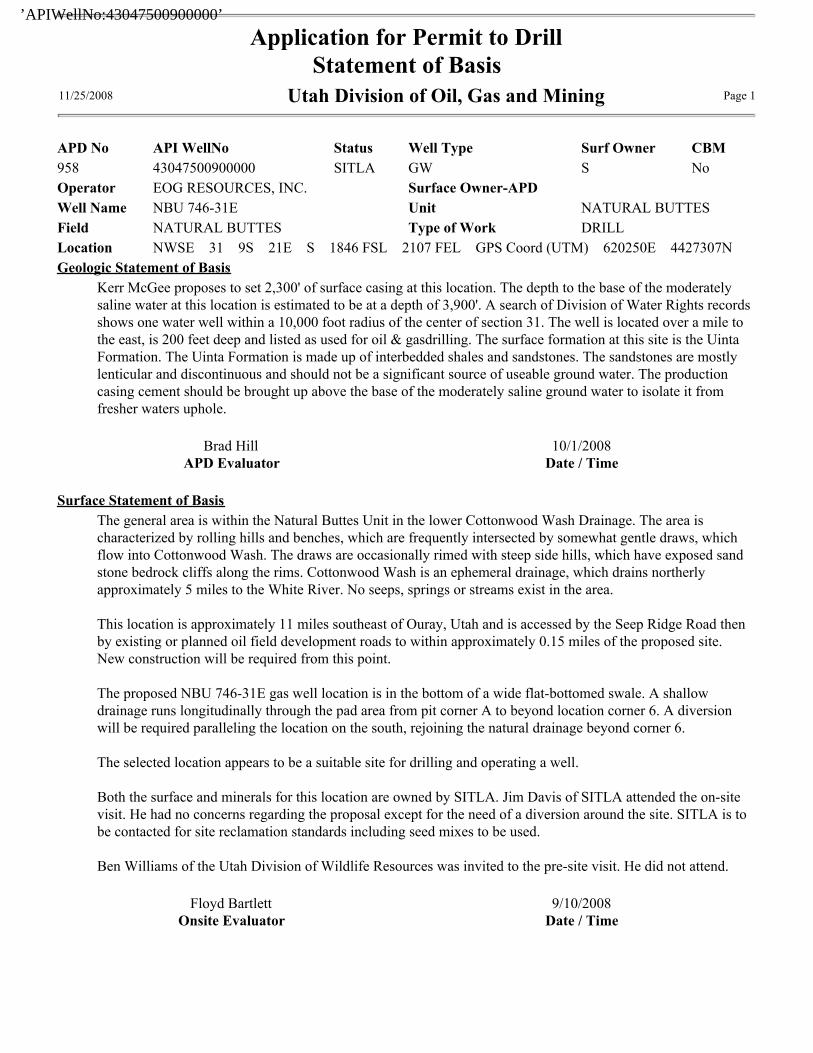
Kerr McGee proposes to set 2,300' of surface casing at this location. The depth to the base of the moderately
saline water at this location is estimated to be at a depth of 3,900'. A search of Division of Water Rights records
shows one water well within a 10,000 foot radius of the center of section 31. The well is located over a mile to
the east, is 200 feet deep and listed as used for oil & gasdrilling. The surface formation at this site is the Uinta
Formation. The Uinta Formation is made up of interbedded shales and sandstones. The sandstones are mostly
lenticular and discontinuous and should not be a significant source of useable ground water. The production
casing cement should be brought up above the base of the moderately saline ground water to isolate it from
fresher waters uphole.
Brad Hill
APD Evaluator
10/1/2008
Date / Time
Surface Statement of Basis
The general area is within the Natural Buttes Unit in the lower Cottonwood Wash Drainage. The area is
characterized by rolling hills and benches, which are frequently intersected by somewhat gentle draws, which
flow into Cottonwood Wash. The draws are occasionally rimed with steep side hills, which have exposed sand
stone bedrock cliffs along the rims. Cottonwood Wash is an ephemeral drainage, which drains northerly
approximately 5 miles to the White River. No seeps, springs or streams exist in the area.
This location is approximately 11 miles southeast of Ouray, Utah and is accessed by the Seep Ridge Road then
by existing or planned oil field development roads to within approximately 0.15 miles of the proposed site.
New construction will be required from this point.
The proposed NBU 746-31E gas well location is in the bottom of a wide flat-bottomed swale. A shallow
drainage runs longitudinally through the pad area from pit corner A to beyond location corner 6. A diversion
will be required paralleling the location on the south, rejoining the natural drainage beyond corner 6.
The selected location appears to be a suitable site for drilling and operating a well.
Both the surface and minerals for this location are owned by SITLA. Jim Davis of SITLA attended the on-site
visit. He had no concerns regarding the proposal except for the need of a diversion around the site. SITLA is to
be contacted for site reclamation standards including seed mixes to be used.
Ben Williams of the Utah Division of Wildlife Resources was invited to the pre-site visit. He did not attend.
Floyd Bartlett
Onsite Evaluator
9/10/2008
Date / Time
Application for Permit to Drill
Statement of Basis11/25/2008 Utah Division of Oil, Gas and Mining Page 1
’APIWellNo:43047500900000’
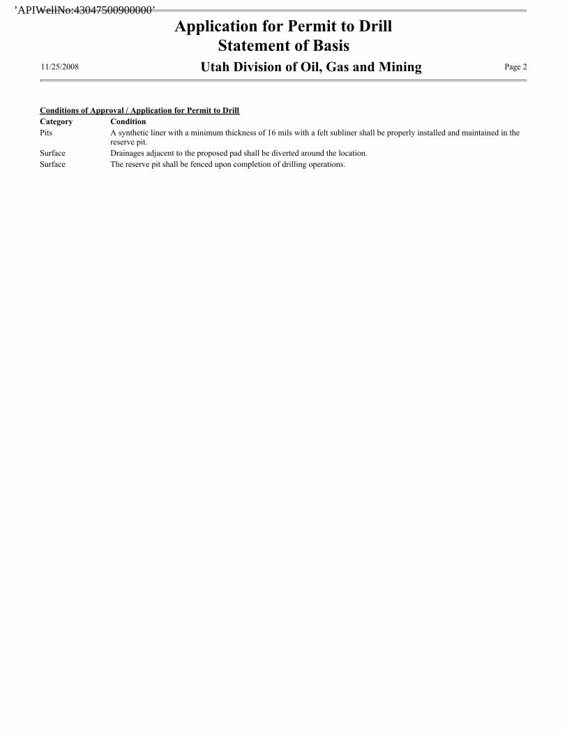
Conditions of Approval / Application for Permit to Drill
Category Condition
Pits A synthetic liner with a minimum thickness of 16 mils with a felt subliner shall be properly installed and maintained in thereserve pit.
Surface Drainages adjacent to the proposed pad shall be diverted around the location.
Surface The reserve pit shall be fenced upon completion of drilling operations.
Application for Permit to Drill
Statement of Basis11/25/2008 Utah Division of Oil, Gas and Mining Page 2
’APIWellNo:43047500900000’
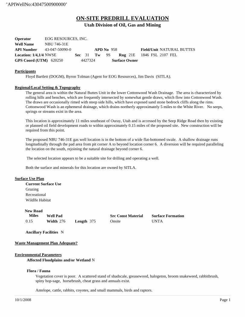
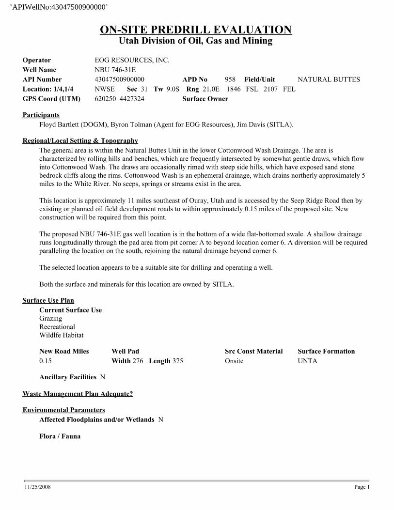
Utah Division of Oil, Gas and MiningON-SITE PREDRILL EVALUATION
APD No 958
ParticipantsFloyd Bartlett (DOGM), Byron Tolman (Agent for EOG Resources), Jim Davis (SITLA).
Regional/Local Setting & TopographyThe general area is within the Natural Buttes Unit in the lower Cottonwood Wash Drainage. The area is characterized by rolling hills and benches, which are frequently intersected by somewhat gentle draws, which flow into Cottonwood Wash. The draws are occasionally rimed with steep side hills, which have exposed sand stone bedrock cliffs along the rims. Cottonwood Wash is an ephemeral drainage, which drains northerly approximately 5 miles to the White River. No seeps, springs or streams exist in the area.
This location is approximately 11 miles southeast of Ouray, Utah and is accessed by the Seep Ridge Road then by existing or planned oil field development roads to within approximately 0.15 miles of the proposed site. New construction will be required from this point.
The proposed NBU 746-31E gas well location is in the bottom of a wide flat-bottomed swale. A shallow drainage runs longitudinally through the pad area from pit corner A to beyond location corner 6. A diversion will be required paralleling the location on the south, rejoining the natural drainage beyond corner 6.
The selected location appears to be a suitable site for drilling and operating a well.
Both the surface and minerals for this location are owned by SITLA.
New RoadMiles
0.15 Width 276 Length 375Src Const MaterialOnsite
Ancillary Facilities N
Waste Management Plan Adequate?
Affected Floodplains and/or Wetland N
Flora / FaunaVegetation cover is poor. A scattered stand of shadscale, greasewood, halogeton, broom snakeweed, rabbitbrush, spiny hop-sage, horsebrush, cheat grass and annuals exist.
Antelope, cattle, rabbits, coyotes, and small mammals, birds and raptors.
Surface FormationUNTA
Operator EOG RESOURCES, INC. Well Name NBU 746-31EAPI Number 43-047-50090-0
Surface Owner
Field/Unit NATURAL BUTTESLocation: 1/4,1/4 NWSE Sec 31 Tw 9S Rng 21E 1846 FSL 2107 FEL GPS Coord (UTM) 620250 4427324
Surface Use Plan
Well Pad
Environmental Parameters
Current Surface UseGrazingRecreationalWildlfe Habitat
10/1/2008 Page 1
’APIWellNo:43047500900000’

Date / Time9/10/2008
EvaluatorFloyd Bartlett
Soil Type and CharacteristicsDeep sandy loam
Erosion Issues N
Sedimentation Issues YA shallow drainage runs longitudinally through the pad area from pit corner A to beyond location corner 6. A diversion will be required paralleling the location on the south, rejoining the natural drainage beyond corner 6.
Site Stability Issues N
Paleo Survey Run? Paleo Potental Observed? Cultural Survey Run? Cultural Resources?
Drainage Diverson Required YA shallow drainage runs longitudinally through the pad area from pit corner A to beyond location corner 6. A diversion will be required paralleling the location on the south, rejoining the natural drainage beyond corner 6.
Berm Required? N
Erosion Sedimentation Control Required? N
Characteristics / RequirementsThe reserve pit is planned in an area of cut in the southeast corner of the location. Dimensions are 75’ x 175’ x 12’ deep with 2’ of freeboard. A liner with a minimum thickness of 16 mils. and a felt sub-liner are required.
Closed Loop Mud Required? N Liner Required? Y Liner Thickness 16 Pit Underlayment Required? Y
Other Observations / Comments
Distance to Groundwater (feet) 100 to 200 5Distance to Surface Water (feet) >1000 0Dist. Nearest Municipal Well (ft) >5280 0Distance to Other Wells (feet) 300 to 1320 10Native Soil Type Mod permeability 10Fluid Type Fresh Water 5Drill Cuttings Normal Rock 0Annual Precipitation (inches) <10 0Affected Populations <10 0Presence Nearby Utility Conduits Not Present 0
Final Score 30 Sensitivity Level1
Reserve Pit
Site-Specific Factors Site Ranking
10/1/2008 Page 2
’APIWellNo:43047500900000’
’APIWellNo:43047500900000’
’APIWellNo:43047500900000’
’APIWellNo:43047500900000’
’APIWellNo:43047500900000’
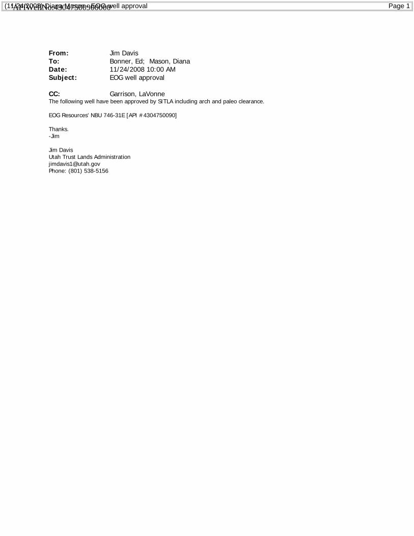
(11/24/2008) Diana Mason - EOG well approval Page 1
From: Jim DavisTo: Bonner, Ed; Mason, DianaDate: 11/24/2008 10:00 AMSubject: EOG well approval
CC: Garrison, LaVonneThe following well have been approved by SITLA including arch and paleo clearance.
EOG Resources' NBU 746-31E [API #4304750090]
Thanks.-Jim
Jim DavisUtah Trust Lands [email protected]: (801) 538-5156
’APIWellNo:43047500900000’
ON-SITE PREDRILL EVALUATIONUtah Division of Oil, Gas and Mining
Operator EOG RESOURCES, INC.
Well Name NBU 746-31E
API Number 43047500900000 APD No 958 Field/Unit NATURAL BUTTES
Location: 1/4,1/4 NWSE Sec 31 Tw 9.0S Rng 21.0E 1846 FSL 2107 FEL
GPS Coord (UTM) 620250 4427324 Surface Owner
Participants
Floyd Bartlett (DOGM), Byron Tolman (Agent for EOG Resources), Jim Davis (SITLA).
Regional/Local Setting & Topography
The general area is within the Natural Buttes Unit in the lower Cottonwood Wash Drainage. The area is
characterized by rolling hills and benches, which are frequently intersected by somewhat gentle draws, which flow
into Cottonwood Wash. The draws are occasionally rimed with steep side hills, which have exposed sand stone
bedrock cliffs along the rims. Cottonwood Wash is an ephemeral drainage, which drains northerly approximately 5
miles to the White River. No seeps, springs or streams exist in the area.
This location is approximately 11 miles southeast of Ouray, Utah and is accessed by the Seep Ridge Road then by
existing or planned oil field development roads to within approximately 0.15 miles of the proposed site. New
construction will be required from this point.
The proposed NBU 746-31E gas well location is in the bottom of a wide flat-bottomed swale. A shallow drainage
runs longitudinally through the pad area from pit corner A to beyond location corner 6. A diversion will be required
paralleling the location on the south, rejoining the natural drainage beyond corner 6.
The selected location appears to be a suitable site for drilling and operating a well.
Both the surface and minerals for this location are owned by SITLA.
Surface Use Plan
Current Surface Use
Grazing
Recreational
Wildlfe Habitat
New Road Miles Well Pad Src Const Material Surface Formation
0.15 Width 276 Length 375 Onsite UNTA
Ancillary Facilities N
Waste Management Plan Adequate?
Environmental Parameters
Affected Floodplains and/or Wetlands N
Flora / Fauna
11/25/2008 Page 1
’APIWellNo:43047500900000’
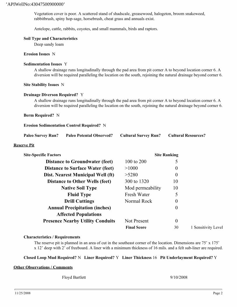
Vegetation cover is poor. A scattered stand of shadscale, greasewood, halogeton, broom snakeweed,
rabbitbrush, spiny hop-sage, horsebrush, cheat grass and annuals exist.
Antelope, cattle, rabbits, coyotes, and small mammals, birds and raptors.
Soil Type and Characteristics
Deep sandy loam
Erosion Issues N
Sedimentation Issues Y
A shallow drainage runs longitudinally through the pad area from pit corner A to beyond location corner 6. A
diversion will be required paralleling the location on the south, rejoining the natural drainage beyond corner 6.
Site Stability Issues N
Drainage Diverson Required? Y
A shallow drainage runs longitudinally through the pad area from pit corner A to beyond location corner 6. A
diversion will be required paralleling the location on the south, rejoining the natural drainage beyond corner 6.
Berm Required? N
Erosion Sedimentation Control Required? N
Paleo Survey Run? Paleo Potental Observed? Cultural Survey Run? Cultural Resources?
Reserve Pit
Site-Specific Factors Site Ranking
Distance to Groundwater (feet) 100 to 200 5
Distance to Surface Water (feet) >1000 0
Dist. Nearest Municipal Well (ft) >5280 0
Distance to Other Wells (feet) 300 to 1320 10
Native Soil Type Mod permeability 10
Fluid Type Fresh Water 5
Drill Cuttings Normal Rock 0
Annual Precipitation (inches) 0
Affected Populations
Presence Nearby Utility Conduits Not Present 0
Final Score 30 1 Sensitivity Level
Characteristics / Requirements
The reserve pit is planned in an area of cut in the southeast corner of the location. Dimensions are 75’ x 175’
x 12’ deep with 2’ of freeboard. A liner with a minimum thickness of 16 mils. and a felt sub-liner are required.
Closed Loop Mud Required? N Liner Required? Y Liner Thickness 16 Pit Underlayment Required? Y
Other Observations / Comments
Floyd Bartlett 9/10/2008
11/25/2008 Page 2
’APIWellNo:43047500900000’

Evaluator Date / Time
11/25/2008 Page 3
’APIWellNo:43047500900000’
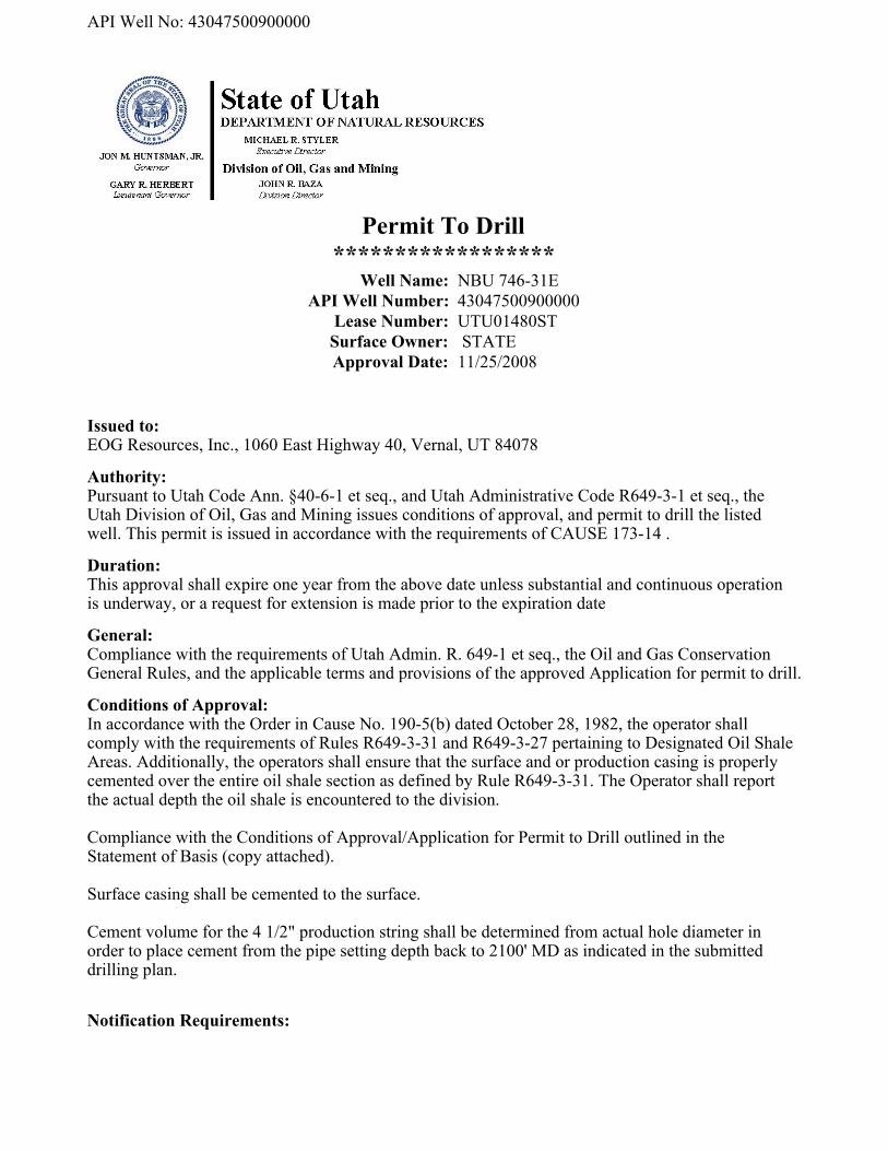
Permit To Drill
******************Well Name: NBU 746-31E
API Well Number: 43047500900000
Lease Number: UTU01480ST
Surface Owner: STATE
Approval Date: 11/25/2008
Issued to:EOG Resources, Inc., 1060 East Highway 40, Vernal, UT 84078
Authority:Pursuant to Utah Code Ann. §40-6-1 et seq., and Utah Administrative Code R649-3-1 et seq., theUtah Division of Oil, Gas and Mining issues conditions of approval, and permit to drill the listedwell. This permit is issued in accordance with the requirements of CAUSE 173-14 .
Duration:This approval shall expire one year from the above date unless substantial and continuous operationis underway, or a request for extension is made prior to the expiration date
General:Compliance with the requirements of Utah Admin. R. 649-1 et seq., the Oil and Gas ConservationGeneral Rules, and the applicable terms and provisions of the approved Application for permit to drill.
Conditions of Approval:In accordance with the Order in Cause No. 190-5(b) dated October 28, 1982, the operator shallcomply with the requirements of Rules R649-3-31 and R649-3-27 pertaining to Designated Oil ShaleAreas. Additionally, the operators shall ensure that the surface and or production casing is properlycemented over the entire oil shale section as defined by Rule R649-3-31. The Operator shall reportthe actual depth the oil shale is encountered to the division.
Compliance with the Conditions of Approval/Application for Permit to Drill outlined in theStatement of Basis (copy attached).
Surface casing shall be cemented to the surface.
Cement volume for the 4 1/2" production string shall be determined from actual hole diameter inorder to place cement from the pipe setting depth back to 2100' MD as indicated in the submitteddrilling plan.
Notification Requirements:The operator is required to notify the Division of Oil, Gas and Mining of the following action during
API Well No: 43047500900000
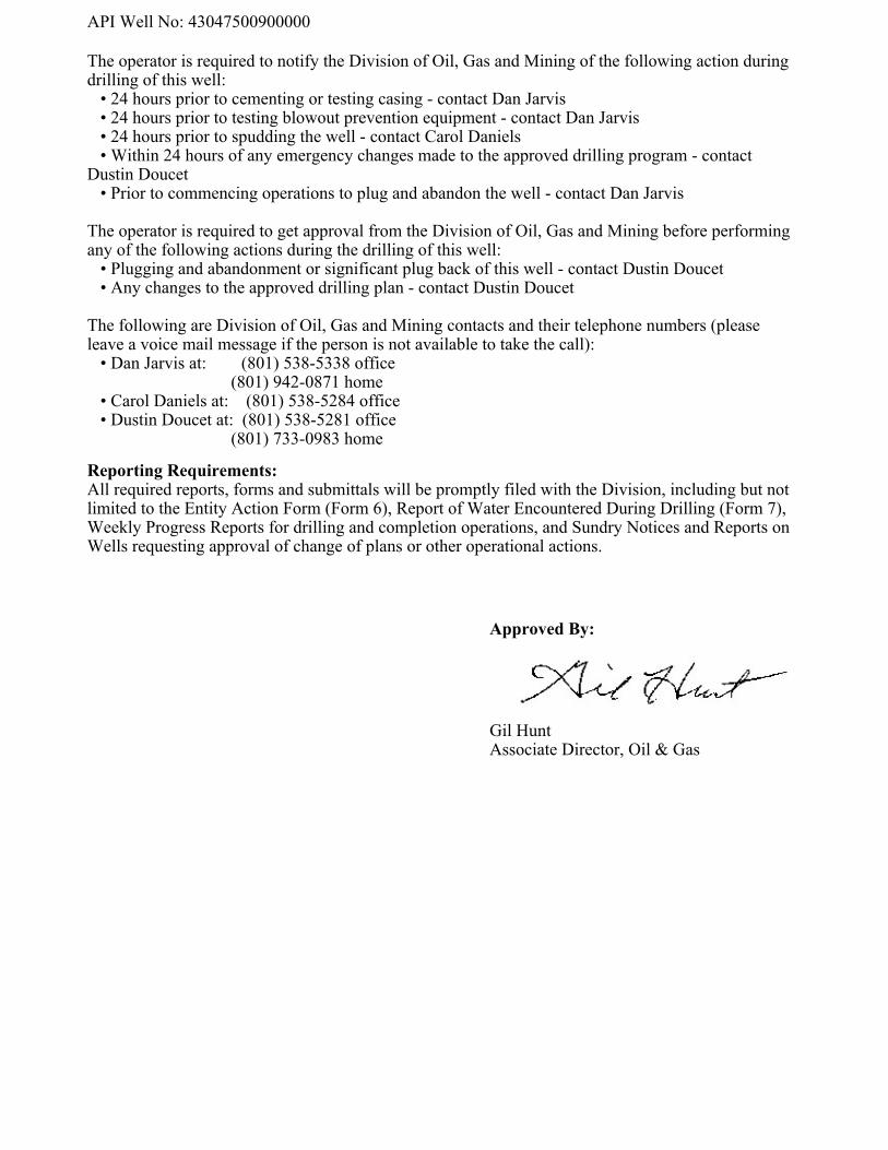
The operator is required to notify the Division of Oil, Gas and Mining of the following action duringdrilling of this well: • 24 hours prior to cementing or testing casing - contact Dan Jarvis • 24 hours prior to testing blowout prevention equipment - contact Dan Jarvis • 24 hours prior to spudding the well - contact Carol Daniels • Within 24 hours of any emergency changes made to the approved drilling program - contactDustin Doucet • Prior to commencing operations to plug and abandon the well - contact Dan Jarvis
The operator is required to get approval from the Division of Oil, Gas and Mining before performingany of the following actions during the drilling of this well: • Plugging and abandonment or significant plug back of this well - contact Dustin Doucet • Any changes to the approved drilling plan - contact Dustin Doucet
The following are Division of Oil, Gas and Mining contacts and their telephone numbers (pleaseleave a voice mail message if the person is not available to take the call): • Dan Jarvis at: (801) 538-5338 office (801) 942-0871 home • Carol Daniels at: (801) 538-5284 office • Dustin Doucet at: (801) 538-5281 office (801) 733-0983 home
Reporting Requirements:All required reports, forms and submittals will be promptly filed with the Division, including but notlimited to the Entity Action Form (Form 6), Report of Water Encountered During Drilling (Form 7),Weekly Progress Reports for drilling and completion operations, and Sundry Notices and Reports onWells requesting approval of change of plans or other operational actions.
Approved By:
Gil HuntAssociate Director, Oil & Gas
API Well No: 43047500900000
API Well No: 43047500900000
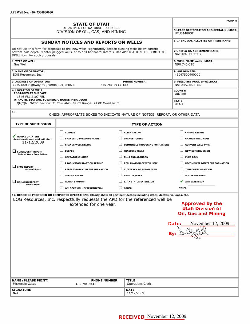
STATE OF UTAHDEPARTMENT OF NATURAL RESOURCES
DIVISION OF OIL, GAS, AND MINING
FORM 9
5.LEASE DESIGNATION AND SERIAL NUMBER: UTU01480ST
SUNDRY NOTICES AND REPORTS ON WELLSDo not use this form for proposals to drill new wells, significantly deepen existing wells below currentbottom-hole depth, reenter plugged wells, or to drill horizontal laterals. Use APPLICATION FOR PERMIT TODRILL form for such proposals.
6. IF INDIAN, ALLOTTEE OR TRIBE NAME:
7.UNIT or CA AGREEMENT NAME: NATURAL BUTTES
1. TYPE OF WELL Gas Well
8. WELL NAME and NUMBER: NBU 746-31E
2. NAME OF OPERATOR: EOG Resources, Inc.
9. API NUMBER: 43047500900000
3. ADDRESS OF OPERATOR: 1060 East Highway 40 , Vernal, UT, 84078
9. FIELD and POOL or WILDCAT: NATURAL BUTTES
4. LOCATION OF WELL FOOTAGES AT SURFACE: 1846 FSL 2107 FEL QTR/QTR, SECTION, TOWNSHIP, RANGE, MERIDIAN: Qtr/Qtr: NWSE Section: 31 Township: 09.0S Range: 21.0E Meridian: S
COUNTY: UINTAH
STATE: UTAH
11.
CHECK APPROPRIATE BOXES TO INDICATE NATURE OF NOTICE, REPORT, OR OTHER DATA
TYPE OF SUBMISSION TYPE OF ACTION
NOTICE OF INTENTApproximate date work will start:
11/12/2009
SUBSEQUENT REPORTDate of Work Completion:
SPUD REPORTDate of Spud:
DRILLING REPORTReport Date:
ACIDIZE ALTER CASING CASING REPAIR
CHANGE TO PREVIOUS PLANS CHANGE TUBING CHANGE WELL NAME
CHANGE WELL STATUS COMMINGLE PRODUCING FORMATIONS CONVERT WELL TYPE
DEEPEN FRACTURE TREAT NEW CONSTRUCTION
OPERATOR CHANGE PLUG AND ABANDON PLUG BACK
PRODUCTION START OR RESUME RECLAMATION OF WELL SITE RECOMPLETE DIFFERENT FORMATION
REPERFORATE CURRENT FORMATION SIDETRACK TO REPAIR WELL TEMPORARY ABANDON
TUBING REPAIR VENT OR FLARE WATER DISPOSAL
WATER SHUTOFF SI TA STATUS EXTENSION APD EXTENSION
WILDCAT WELL DETERMINATION OTHER OTHER:
12. DESCRIBE PROPOSED OR COMPLETED OPERATIONS. Clearly show all pertinent details including dates, depths, volumes, etc.
EOG Resources, Inc. respectfully requests the APD for the referenced well beextended for one year.
NAME (PLEASE PRINT) Mickenzie Gates
TITLE Operations Clerk
SIGNATURE N/A
DATE 11/12/2009
PHONE NUMBER:435 781-9111 Ext
PHONE NUMBER435 781-9145
November 12, 2009
November 12, 2009
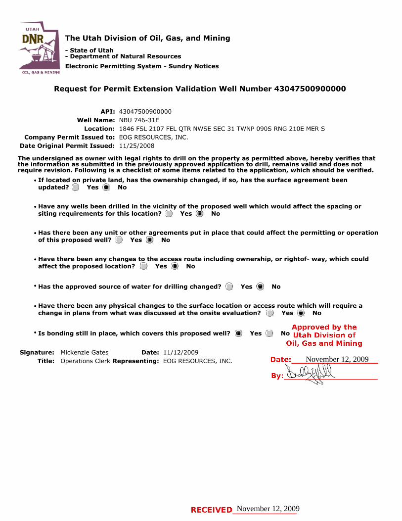
The Utah Division of Oil, Gas, and Mining
- State of Utah- Department of Natural Resources
Electronic Permitting System - Sundry Notices
Request for Permit Extension Validation Well Number 43047500900000
API: 43047500900000Well Name: NBU 746-31E
Location: 1846 FSL 2107 FEL QTR NWSE SEC 31 TWNP 090S RNG 210E MER SCompany Permit Issued to: EOG RESOURCES, INC.
Date Original Permit Issued: 11/25/2008
The undersigned as owner with legal rights to drill on the property as permitted above, hereby verifies thatthe information as submitted in the previously approved application to drill, remains valid and does notrequire revision. Following is a checklist of some items related to the application, which should be verified.
If located on private land, has the ownership changed, if so, has the surface agreement beenupdated? Yes No
Have any wells been drilled in the vicinity of the proposed well which would affect the spacing orsiting requirements for this location? Yes No
Has there been any unit or other agreements put in place that could affect the permitting or operationof this proposed well? Yes No
Have there been any changes to the access route including ownership, or rightof- way, which couldaffect the proposed location? Yes No
Has the approved source of water for drilling changed? Yes No
Have there been any physical changes to the surface location or access route which will require achange in plans from what was discussed at the onsite evaluation? Yes No
Is bonding still in place, which covers this proposed well? Yes No
Signature: Mickenzie Gates Date: 11/12/2009
Title: Operations Clerk Representing: EOG RESOURCES, INC.
November 12, 2009
November 12, 2009

API Well No: 43047500900000
STATE OF UTAHDEPARTMENT OF NATURAL RESOURCES
DIVISION OF OIL, GAS, AND MINING
FORM 9
5.LEASE DESIGNATION AND SERIAL NUMBER: UO1480ST
SUNDRY NOTICES AND REPORTS ON WELLSDo not use this form for proposals to drill new wells, significantly deepen existing wells below currentbottom-hole depth, reenter plugged wells, or to drill horizontal laterals. Use APPLICATION FOR PERMIT TODRILL form for such proposals.
6. IF INDIAN, ALLOTTEE OR TRIBE NAME:
7.UNIT or CA AGREEMENT NAME: NATURAL BUTTES
1. TYPE OF WELL Gas Well
8. WELL NAME and NUMBER: NBU 746-31E
2. NAME OF OPERATOR: KERR-MCGEE OIL & GAS ONSHORE, L.P.
9. API NUMBER: 43047500900000
3. ADDRESS OF OPERATOR: PHONE NUMBER: P.O. Box 173779 1099 18th Street, Suite 600, Denver, CO, 80217 3779 720 929-6007 Ext
9. FIELD and POOL or WILDCAT: NATURAL BUTTES
4. LOCATION OF WELL FOOTAGES AT SURFACE: 1846 FSL 2107 FEL QTR/QTR, SECTION, TOWNSHIP, RANGE, MERIDIAN: Qtr/Qtr: NWSE Section: 31 Township: 09.0S Range: 21.0E Meridian: S
COUNTY: UINTAH
STATE: UTAH
11.
CHECK APPROPRIATE BOXES TO INDICATE NATURE OF NOTICE, REPORT, OR OTHER DATA
TYPE OF SUBMISSION TYPE OF ACTION
NOTICE OF INTENTApproximate date work will start:
11/25/2010
SUBSEQUENT REPORTDate of Work Completion:
SPUD REPORTDate of Spud:
DRILLING REPORTReport Date:
ACIDIZE ALTER CASING CASING REPAIR
CHANGE TO PREVIOUS PLANS CHANGE TUBING CHANGE WELL NAME
CHANGE WELL STATUS COMMINGLE PRODUCING FORMATIONS CONVERT WELL TYPE
DEEPEN FRACTURE TREAT NEW CONSTRUCTION
OPERATOR CHANGE PLUG AND ABANDON PLUG BACK
PRODUCTION START OR RESUME RECLAMATION OF WELL SITE RECOMPLETE DIFFERENT FORMATION
REPERFORATE CURRENT FORMATION SIDETRACK TO REPAIR WELL TEMPORARY ABANDON
TUBING REPAIR VENT OR FLARE WATER DISPOSAL
WATER SHUTOFF SI TA STATUS EXTENSION APD EXTENSION
WILDCAT WELL DETERMINATION OTHER OTHER:
12. DESCRIBE PROPOSED OR COMPLETED OPERATIONS. Clearly show all pertinent details including dates, depths, volumes, etc.
Kerr-McGee Oil & Gas Onshore, L.P. (Kerr-McGee) respectfully requests anextension to this APD for the maximum time allowed. Please contact the
undersigned with any questions and/or comments. Thank you.
NAME (PLEASE PRINT) PHONE NUMBER Danielle Piernot 720 929-6156
TITLE Regulatory Analyst
SIGNATURE N/A
DATE 11/22/2010
November 22, 2010
11/23/2010
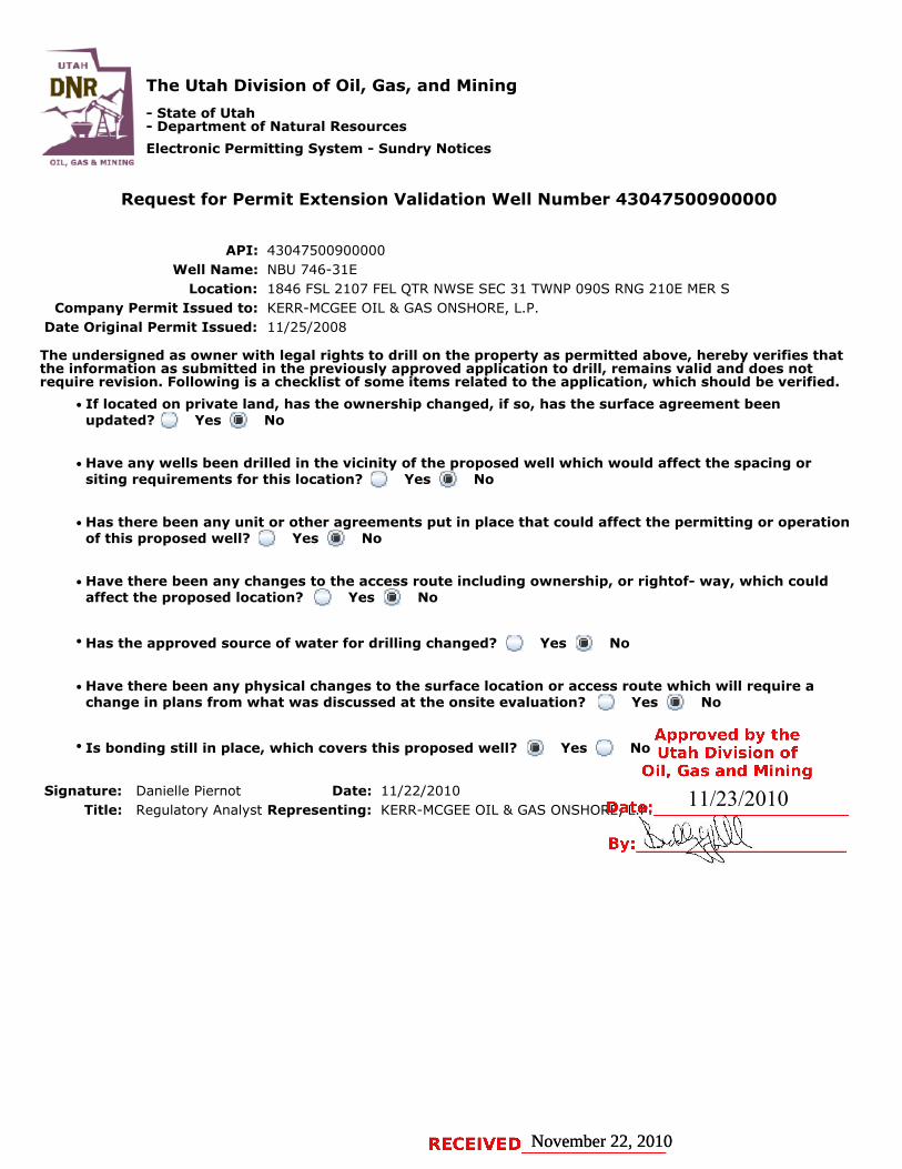
The Utah Division of Oil, Gas, and Mining
- State of Utah- Department of Natural Resources
Electronic Permitting System - Sundry Notices
Request for Permit Extension Validation Well Number 43047500900000
API: 43047500900000Well Name: NBU 746-31E
Location: 1846 FSL 2107 FEL QTR NWSE SEC 31 TWNP 090S RNG 210E MER SCompany Permit Issued to: KERR-MCGEE OIL & GAS ONSHORE, L.P.
Date Original Permit Issued: 11/25/2008
The undersigned as owner with legal rights to drill on the property as permitted above, hereby verifies thatthe information as submitted in the previously approved application to drill, remains valid and does notrequire revision. Following is a checklist of some items related to the application, which should be verified.
If located on private land, has the ownership changed, if so, has the surface agreement beenupdated? Yes No
Have any wells been drilled in the vicinity of the proposed well which would affect the spacing orsiting requirements for this location? Yes No
Has there been any unit or other agreements put in place that could affect the permitting or operationof this proposed well? Yes No
Have there been any changes to the access route including ownership, or rightof- way, which couldaffect the proposed location? Yes No
Has the approved source of water for drilling changed? Yes No
Have there been any physical changes to the surface location or access route which will require achange in plans from what was discussed at the onsite evaluation? Yes No
Is bonding still in place, which covers this proposed well? Yes No
Signature: Danielle Piernot Date: 11/22/2010
Title: Regulatory Analyst Representing: KERR-MCGEE OIL & GAS ONSHORE, L.P.
November 22, 2010November 22, 2010
11/23/2010


