
PRELIMINARY ENVIRONMENTAL ASSESSMENT
SURFACE TRANSPORTATION BOARD
FINANCE DOCKET NO. 34936
Northern Columbia Basin Railroad Project
Grant County, Washington
EXECUTIVE SUMMARY
Co-Lead Agencies Surface Transportation Board – Section of Environmental Analysis
and Washington State Department of Transportation
Decision ID No. FD 39478 Service Date: 11/07/2008 Comment Due Date: 12/08/2008


Northern Columbia Basin Railroad Project Preliminary Environmental Assessment Executive Summary
Prepared by the
Surface Transportation Board Section of Environmental Analysis
and the
Washington State Department of Transportation
November 7, 2008
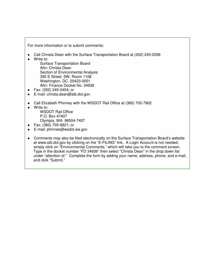
For more information or to submit comments:
� Call Christa Dean with the Surface Transportation Board at (202) 245-0299 � Write to: Surface Transportation Board Attn: Christa Dean Section of Environmental Analysis 395 E Street, SW, Room 1108 Washington, DC 20423-0001 Attn: Finance Docket No. 34936 � Fax: (202) 245-0454; or � E-mail: [email protected] � Call Elizabeth Phinney with the WSDOT Rail Office at (360) 705-7902 � Write to: WSDOT Rail Office P.O. Box 47407 Olympia, WA 98504-7407 � Fax: (360) 705-6821; or � E-mail: [email protected] � Comments may also be filed electronically on the Surface Transportation Board’s website
at www.stb.dot.gov by clicking on the “E-FILING” link. A Login Account is not needed; simply click on “Environmental Comments,” which will take you to the comment screen. Type in the docket number “FD 34936” then select “Christa Dean” in the drop down list under “attention of.” Complete the form by adding your name, address, phone, and e-mail, and click “Submit.”

Materials can be provided in alternative formats: large print, Braille, cassette tape, or on
computer disk for people with disabilities by calling the Office of Equal Opportunity (OEO)
at (360) 705-7097. Persons who are deaf or hard of hearing may contact OEO through
the Washington Relay Service at 7-1-1.
Title VI
WSDOT ensures full compliance with Title VI of the Civil Rights Act of 1964 by
prohibiting discrimination against any person on the basis of race, color,
national origin or sex in the provision of benefits and services resulting
from its federally assisted programs and activities.
For questions regarding WSDOT's Title VI Program, you may
contact the Department's Title VI Coordinator at (360) 705-7098.

This page intentionally left blank.
Northern Columbia Basin Railroad Project November 2008
Preliminary Environmental Assessment Page i
Table of Contents
Executive Summary ..............................................................ES-1
What is the Northern Columbia Basin Railroad Project? ............................ES-1
Why did the STB and WSDOT prepare and Environmental Assessment? .ES-2
Why is the Port of Moses Lake proposing this rail project?........................ES-4
What is the physical setting of the project area?..........................................ES-5
What alternatives were considered?.............................................................ES-5
What potential environmental impacts could result from
the Build Alternative? ..................................................................................ES-7
How can I comment on the Northern Columbia Basin Railroad Project?..ES11
Exhibits
Exhibit ES.1 Project Location.....................................................................ES-3
Exhibit ES.2 Existing Rail Systems in the Project Area.............................ES-6
Exhibit ES.3 Comparison of Alternatives.................................................ES-13

November 2008 Northern Columbia Basin Railroad Project
Page ii Preliminary Environmental Assessment
This page intentionally left blank.
Northern Columbia Basin Railroad Project November 2008
Preliminary Environmental Assessment Page ES-1
Executive Summary
On August 28, 2008, the Port of Moses Lake (Port) filed a petition with the
Surface Transportation Board (STB) seeking an exemption under 49 U.S.C.
10502 from the prior approval requirements of 49 U.S.C. 10901 for the
construction and acquisition of approximately 11.5 miles of rail line in Grant
County, Washington.1 Columbia Basin Railroad Company, Inc. (CBRW)
intends to file a verified notice of exemption to operate over the rail lines that
are the subject of the Port’s Petition for Exemption. The proposed rail project
(also known as the Build Alternative) is the action that is evaluated in this
Preliminary Environmental Assessment (EA).
The STB, pursuant to 49 U.S.C. 10901, is the federal agency responsible for
granting authority for the construction and operation of new rail line facilities.
The Washington State Department of Transportation (WSDOT) is responsible
for improving the state’s transportation systems, including short-line rail
systems.
The STB’s Section of Environmental Analysis (SEA) and WSDOT are issuing
this Preliminary Environmental Assessment (EA) for public review and
comment. SEA will consider all comments received on this document in
making its final recommendations to the STB. The STB will consider the
entire environmental record, all comments, and SEA’s final recommendations
in making its final decision in this proceeding. The STB will decide whether
to approve, approve with conditions (which could include environmental
conditions to mitigate impacts), or deny the proposed action.
What is the Northern Columbia Basin Railroad Project?
The proposed project, known as the Northern Columbia Basin Railroad
(NCBR) Project, includes the construction of two new rail line segments and
the acquisition and refurbishment of an existing rail segment to provide rail
access to land designated and zoned for industrial uses along Wheeler Road
(Road 3 NE) and at the Grant County International Airport (GCIA).2 Although
CBRW operates rail lines in the City of Moses Lake and Grant County, the
industrial areas along Wheeler Road (Road 3 NE) and the eastern side of the
GCIA are not currently served by rail.
1 The proposed 11.5-mile-long rail route includes the acquisition and rehabilitation of approximately three
miles of existing track that is currently owned by Columbia Basin Railroad Company (CBRW). In
addition, the proposed 11.5-mile-long rail route includes the acquisition of approximately 0.5 miles of
existing track, for which no construction or rehabilitation is planned. Accordingly, the 0.5-mile rail
segment was not evaluated in this EA. 2 Two airports are located in the project vicinity. The larger airport, Grant County International Airport
(GCIA), is located north and west of Randolph Road. Moses Lake Municipal Airport is located north of
Wheeler Road (Road 3 NE) and east of Crab Creek / Parker Horn. GCIA is the airport that would be
accessed by the proposed project.
November 2008 Northern Columbia Basin Railroad Project
Page ES-2 Preliminary Environmental Assessment
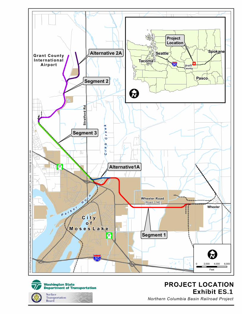
The project location is shown in Exhibit ES.1. The entire proposed route is
would be between 11.1 miles and 11.5 miles long, depending on the alternative
selected at the western end of the project corridor. The entire rail route would
be owned by the Port and operated by CBRW.
Segment 1 (4.5 miles) would begin at the existing CBRW rail line at the
community of Wheeler, diverge south of Wheeler Road (Road 3 NE), and
proceed west, paralleling Wheeler Road (Road 3 NE). Segment 1 would then
swing to the northwest and cross back over Wheeler Road (Road 3 NE) and
cross Parker Horn / Crab Creek at one of two alternative locations (Segment 1
or Alternative 1A). Segment 2 would start at the western end of Segment 3
and would proceed north to the eastern side of the GCIA property. At the
northern end of Segment 2, one of two alternatives would be constructed,
either Segment 2 (3.1 miles of track ending on the west side of the GCIA
industrial area) or Alternative 2A (3.6 miles of track ending on the east side of
the GCIA industrial area). Segment 3, an existing 3.0-mile rail line located
between Parker Horn and the GCIA, would be acquired and refurbished by the
Port. The Port would also acquire a total of approximately 0.5 miles of rail
line located north of the conjunction of Segments 2 and 3. However, no
construction or rehabilitation work is proposed on that portion of the rail line,
and it is not evaluated in this EA.
The purpose of the proposed project is to provide rail service to lands
designated for industrial development in the northern part of the City of Moses
Lake as well as to the south and east of the GCIA, to enhance opportunities for
economic development, and to attract new rail-dependent businesses to those
areas. Depending on the demand for rail service, rail traffic would increase as
needed from the current one train per month (or less) up to a reasonably
foreseeable future maximum of two trains per day (one round trip).
Why did the STB and WSDOT prepare an Environmental Assessment?
Under the National Environmental Policy Act (NEPA),3 the STB must take
into account in its decision-making the environmental impacts of its actions,
including direct, indirect and cumulative impacts. The STB must consider
these impacts before making its final decision in a case. SEA assists the STB
in meeting this responsibility by conducting an independent environmental
review of cases filed with the agency and preparing any necessary EA or
Environmental Impact Statement (EIS).
3 40 CFR 1500 et seq.
P a r k e r Ho
r n
Cr
ab
C
re
ek
Grant CountyIn te rna tional
Airpor t
Segment 2
Segment 3
Segment 1
Wheeler Road
Wheeler
Str
atfo
rd R
d
(Road 3 NE)
Alternative1A
Alternative 2A
PROJECT LOCATIONExhibit ES.1
Northern Columbia Basin Railroad Project
D:\G
ISD
ATA
\pro
ject
s\w
ash\
wsd
ot\M
oses
Lake
\map
_doc
s\m
xd\F
igur
es\E
XH
IBIT
_PR
OJE
CT_
VIC
INIT
Y_E
A.m
xd -
10/9
/200
8 @
10:
12:0
1 A
M
ProjectLocation
GrantCounty
Pasco
Tacoma
Seattle Spokane
C i t yo f
M o s e s L a k e
0 2,000 4,000 6,000
Feet
November 2008 Northern Columbia Basin Railroad Project
Page ES-4 Preliminary Environmental Assessment
An EA is a public disclosure document required by NEPA that analyzes
potential environmental impacts, as well as alternatives to the proposed action.
Coordination with federal, state, and local agencies; applicants; Tribes; and the
public are key elements in the preparation of an EA. When the preliminary
analysis is completed, an EA is issued and government agencies, Tribes, and
the public have an opportunity to review and comment on the document. The
purpose of an EA is to provide enough analysis to determine whether a
proposed project would have significant environmental impacts, in which case
an Environmental Impact Statement is required. When no significant impacts
are found or significant impacts can be mitigated, that results in a “Finding of
No Significant Impact.”
Under Washington’s State Environmental Policy Act (SEPA)4, any agency that
proposes to take an official action is required to perform an environmental
review to identify any benefits and/or impacts that may result from the action.
Therefore, SEA and WSDOT prepared this EA in accordance with NEPA and
SEPA, as well as the Council on Environmental Quality (CEQ) guidelines,5 the
STB’s environmental regulations,6 WSDOT requirements,
7 Executive Orders,
8
and other applicable federal and state laws.
Why is the Port of Moses Lake proposing this rail project?
The purpose of the proposed NCBR Project is to provide rail service to lands
designated for industrial development in the northern part of the City of Moses
Lake as well as to the south and east side of the GCIA, to enhance
opportunities for economic development, and to attract new, rail-dependent
businesses to those areas.
The proposed project includes the following:
• Segment 1 - Building a new rail line between the community of Wheeler
and Parker Horn (a water body and an arm of Moses Lake) or Crab Creek
to join the existing line (Segment 3);
• Segment 2 - Extending the existing track, which currently terminates just
south of the GCIA, to the industrial lands located east of the GCIA; and
4 Revised Code of Washington (RCW). 43.21C.
5 43 CFR § 1508.9(b).
6 49 CFR Part 1105.
7 WSDOT’s Environmental Procedures Manual outlines the department's legal requirements related to
natural and man-made environmental resources. The Environmental Procedures Manual provides
guidance on environmental procedures for WSDOT and its environmental consultants. The Environmental
Procedures Manual may be viewed online at
http://www.wsdot.wa.gov/Publications/Manuals/M31-11.htm. 8 Executive Order (EO) 12898 (Federal Register 1994), Federal Actions to Address Environmental Justice
in Minority Populations and Low-Income Populations.

Northern Columbia Basin Railroad Project November 2008
Preliminary Environmental Assessment Page ES-5
• Segment 3 - Refurbishing the existing track between Parker Horn and the
GCIA.
The new rail line segments would be owned and constructed by the Port.
Segment 3 (existing track) would be acquired by the Port from CBRW and
would be refurbished by the Port. As stated above, the entire route would be
operated by CBRW.
Although the proposed project would allow trains to bypass downtown Moses
Lake, the project does not include abandonment of the existing rail line that
runs through downtown Moses Lake. If that line were proposed for
abandonment in the future, that would be a separate action before the STB and
would be subject to a separate environmental review by SEA.
What is the physical setting of the project area?
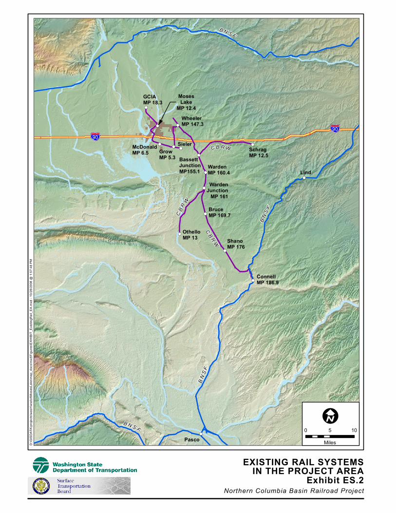
The project area is located in central Washington, in Grant County, north of
I-90. Exhibit ES.2 shows the existing rail lines and general topography in the
project vicinity. The project area is located partially in the northern portion of
the City of Moses Lake and partially in unincorporated Grant County.
Although generally zoned and designated for industrial use, at this time land in
Segments 1 and 2 is primarily being used for agricultural purposes.
Segment 3, the existing line, is adjacent to the Longview residential
neighborhood and the Longview Elementary School.
The project area is located northeast of Moses Lake in the Crab Creek
Watershed. Upper Crab Creek originates on the northeastern Columbia River
Plateau and flows to Moses Lake at Parker Horn and ultimately to the
Columbia River. Local topography consists of relatively flat uplands broken
by the Crab Creek and Parker Horn drainages, where the topography slopes
downward to the creek.
What alternatives were considered?
Two alternatives are analyzed in depth in the EA: the Build Alternative, which
includes the construction of Segments 1 and 2 and the acquisition and
rehabilitation of existing Segment 3, and the No Build Alternative. Within
Segment 1, two alternative water crossings (at Parker Horn and Crab Creek)
were evaluated, and within Segment 2, two alternative routes on the eastern
side of the GCIA were evaluated. The EA also includes discussion of two
additional alternatives initially considered, but rejected, due to the length of
those routes and associated adverse environmental impacts. In addition, those
two alternatives were rejected because they did not meet the purpose and need
of the proposed project, which is described in Chapter Two. A comparison of
all the alternatives considered can be found at the end of this Executive
Summary, in Exhibit ES.3.
B N S F
C B R W
CB
RW
BN
SF
CB
RW
BN
SF
B N S F
GCIAMP 18.3
WheelerMP 147.3
MosesLake
MP 12.4
McDonaldMP 6.5 Grow
MP 5.3
SielerSchragMP 12.5
BassettJunctionMP155.1
OthelloMP 13
BruceMP 169.7
Lind
ShanoMP 176
ConnellMP 186.9
Pasco
WardenMP 160.4
WardenJunction
MP 161
EXISTING RAIL SYSTEMSIN THE PROJECT AREA
Exhibit ES.2Northern Columbia Basin Railroad Project
D:\G
ISD
ATA
\pro
ject
s\w
ash\
wsd
ot\M
oses
Lake
\map
_doc
s\m
xd\F
igur
es\E
XH
IBIT
_Exi
stin
gRai
l_E
A.m
xd -
10/2
8/20
08 @
1:5
7:48
PM
0 5 10
Miles

Northern Columbia Basin Railroad Project November 2008
Preliminary Environmental Assessment Page ES-7
What potential environmental impacts could result from the Build Alternative?
The project team identified potential adverse environmental impacts that could
result from the proposed project. Chapter Five contains a more detailed
discussion of these potential impacts, and Exhibit ES.3 provides a summary of
potential environmental impacts for all alternatives considered. SEA and
WSDOT have incorporated mitigation measures that would avoid, reduce, or
otherwise mitigate all identified potentially adverse environmental impacts.
All mitigation measures are discussed in detail in Chapter Six.
The following is an overview of potential environmental impacts that could
result from the proposed rail project.
Air Quality, Energy, Noise and Visual Quality
Grant County is in attainment for all criteria air pollutants. Because the
proposed project is expected to result in a maximum of two trains (one round
trip) per day for the foreseeable future, impacts to air quality, energy, and noise
are not expected to be significant. The EA includes measures to minimize dust
and noise during construction and to revegetate disturbed areas following
construction.
Cultural Resources
A cultural resources survey of the project area was prepared and sent to the
Washington Department of Archaeology and Historic Preservation (State
Historic Preservation Office or SHPO), the Colville Confederated Tribes, the
Confederated Tribes and Bands of the Yakama Nation, the Confederated
Tribes of the Warm Springs Reservation of Oregon, and the Wanapum Tribe
for review. Based on the results of the survey and initial consultations with the
SHPO, the project team determined that there are no prehistoric archaeological
sites, historic period archaeological sites, or traditional cultural properties
located within the project area.
However, the project team identified 20 potential historic resources (sites that
are 50 years old or older) within the study area; one of those resources, the
Columbia Basin East Low Canal Feeder Canals system, has been determined
to be eligible for listing on the National Register of Historic Places (NRHP).
The proposed rail project is not expected to have an adverse effect on any
historic resources, but any sites that are eligible for the NRHP would not be
disturbed prior to completion of the Section 106 review process of the National
Historic Preservation Act, 16 U.S.C. 470f (NHPA).
Because there are certain land parcels that the project team was unable to
evaluate, the SHPO has recommended that SEA and WSDOT develop a
programmatic agreement (PA) to ensure that cultural resources are assessed on

November 2008 Northern Columbia Basin Railroad Project
Page ES-8 Preliminary Environmental Assessment
these parcels prior to initiation of construction. Accordingly, the project team
is preparing a PA pursuant to the requirements of Section 106 of the NHPA.
In addition, in the event that any unanticipated historic or cultural properties,
archaeological sites, human remains, funerary items, or assorted artifacts are
discovered during the proposed construction activities, the Port would be
required to cease work and notify the SHPO, SEA, WSDOT, interested
federally-recognized Tribes, and consulting parties, if any, in order to
coordinate as appropriate to protect those resources.
Fish, Wildlife, and Vegetation
The proposed project is not expected to result in any adverse impacts to
federally-listed threatened or endangered species or critical habitats. On
August 28, 2008, SEA and WSDOT submitted a letter to the U.S. Fish and
Wildlife Service requesting a concurrence with this determination.
Construction of the proposed crossing at Crab Creek for Alternative 1A would
impact a substantially smaller area than construction of the proposed crossing
at Parker Horn for Segment 1 because Crab Creek is less than half as wide as
Parker Horn. Alternative 1A would therefore have fewer impacts on biological
resources.
The proposed project does have the potential to adversely affect the following
state priority species: bald eagles, burrowing owls, Yuma myotis, Townsend’s
big-eared bat, and northern leopard frog. However, through design measures
and the implementation of mitigation measures recommended by SEA and
WSDOT, these impacts would be minimized or avoided.
Hazardous Materials
Based on several screening criteria, 19 hazardous materials sites were found
within the study area. Of these 19 sites, 13 were determined to be at low risk,
four were determined to be at moderate risk, and two were determined to be at
high risk of being disturbed by the proposed construction activities. To
mitigate or avoid such risks, SEA and WSDOT have incorporated measures
into the mitigation, including consultation and coordination with the U.S.
Environmental Protection Agency’s Region 10 Office and the Washington
State Department of Ecology (Ecology) to ensure that appropriate investigation
and mitigation are conducted prior to finalizing design plans and construction
specifications. In addition, to minimize any impacts associated with accidental
spills of hazardous materials, the preparation of a Spill Prevention, Control and
Countermeasures Plan and an emergency response plan would be required.
Land Use
Construction of the proposed project would not have significant land use
impacts. Although the route would cross existing farmland, there is no prime
or unique farmland and the land is zoned primarily for industrial use. In
Northern Columbia Basin Railroad Project November 2008
Preliminary Environmental Assessment Page ES-9
addition, most of the land is designated for industrial development. The
proposed project would require between 93 and 100 acres of right of way,
depending on the alternative selected. This includes approximately 55 acres
for Segment 1 or Alternative 1A and approximately 38 acres for Segment 2 or
45 acres for Alternative 2A. One business would need to be relocated;
however, no residences would be acquired and no residents would be
displaced. To mitigate or avoid land use impacts, the Port would be required
to negotiate with any landowners whose property would be affected or whose
land access would be severed. In addition, the Port would be required to abide
by all requirements of the Uniform Relocation Assistance and Real Property
Acquisition Policies Act of 1970.
Social Elements and Environmental Justice
Along Segments 1 and 2, the proposed project would not divide or separate
any community or population groups. Along Segment 3, the existing rail line
serves as a physical barrier between the Longview neighborhood and
Longview Elementary School. Impacts along Segment 3 would be limited
because the rail line already exists in this location, and because the rail traffic
is expected to be low (two trains per day, one round trip) for the foreseeable
future. SEA and WSDOT have included mitigation measures in the EA to
address safety concerns, including the following measures: coordination with
the Longview Elementary School, the City of Moses Lake, and community
organizations to ensure that railroad safety programs (such as Operation
Lifesaver) and other measures are implemented.
Grant County and the City of Moses Lake have greater minority and low-
income populations than Washington State as a whole. Some of these
populations are located within the study area for Segment 3. Because the rail
line in Segment 3 already exists, and because the rail traffic is expected to be
low (two trains per day, one round trip) for the foreseeable future, the proposed
project would not have a high or disproportionate adverse effect on these
populations.
Traffic
The Build Alternative would require seven new at-grade crossings of public
roads and would include the upgrade of two existing crossings. Accordingly,
the Port would be required to install the necessary signs, lighting, and safety
warnings for all at-grade crossings. SEA and WSDOT have also incorporated
mitigation measures for the proposed construction period to ensure minimal
disruption to traffic along public roadways. The proposed rail operations
would not be expected to cause significant traffic delays or accident impacts
due to the low traffic levels expected on the route.

November 2008 Northern Columbia Basin Railroad Project
Page ES-10 Preliminary Environmental Assessment
Water Resources
Segment 1 would cross six irrigation canals and two drainage ditches. The
Port would be required to install culverts or bridges or otherwise assure that
irrigation and drainage water would not be affected.
The proposed project would build a bridge across Parker Horn for Segment 1
or across Crab Creek for Alternative 1A. The bridge would be designed to
ensure that stormwater did not enter the water body. Specific design and
construction measures would prevent impacts to the water during bridge
construction.
Construction could result in sediments being washed into waterways. To avoid
or minimize impacts to water resources, best management practices and other
mitigation measures would be implemented to control erosion, sedimentation,
and release of any contaminants during construction and operation of the
proposed project.
The Port would be required to coordinate with federal, state, and local agencies
to obtain all necessary permits for work in and around water resources,
including Clean Water Act permit applications to the U.S. Army Corps of
Engineers and Ecology, and the Port would also be required to comply with
local agency requirements mandated by Washington State’s Growth
Management Act and the Shoreline Management Act.
Wetlands
Wetlands are found along Segment 1 and Alternative 1A on either side of
Parker Horn and Crab Creek. Construction of Segment 1 across Parker Horn
would have a direct adverse impact on 3.02 acres of Category 3 wetlands, and
would have indirect adverse impacts, such as fragmentation or shading, on an
additional 3.25 acres of wetlands within 50 feet of the proposed track, for a
total impact area of 6.27 acres. Construction of Alternative 1A across Crab
Creek would have direct adverse impacts on approximately 2.14 acres of
Category 3 wetlands, and would have indirect adverse impacts on
approximately 2.514 acres of wetlands within 50 feet of the proposed track, for
a total impact area of 4.654 acres.
Accordingly, to mitigate impacts on wetlands, SEA and WSDOT have
included measures in the EA, such as the preparation of a Wetland Mitigation
Plan that describes measures to compensate for wetlands affected directly or
indirectly by the proposed project.
Conclusion
The proposed project would provide new rail service to the northern part of the
City of Moses Lake and to the south and east of GCIA to lands that have been
designated for industrial development. Implementing the proposed project
Northern Columbia Basin Railroad Project November 2008
Preliminary Environmental Assessment Page ES-11
would expand railroad service and add to the existing transportation network.
According to project stakeholders,9 the project would help attract new
businesses to the area and contribute to improving the local economy.
During the scoping process, SEA and WSDOT solicited comments from
federal, state, and local agencies; Tribes; and the public. Comments received
during the scoping process are addressed in the EA and were considered in the
development of mitigation measures.
Under the No Build Alternative, the proposed project would not be constructed
and rail service would continue on the existing CBRW system. In addition,
under this alternative there would be no potential for rail service to lands
designated for industrial development in the northern part of the City of Moses
Lake or to the south or eastern part of the GCIA.
Based on available information from all sources to date, SEA and WSDOT
preliminarily conclude that, as currently proposed, the construction, acquisition
and operation of approximately 11.5 miles of rail line in Grant County (the
Build Alternative) would not significantly affect the quality of the natural or
human environment provided that all the recommended mitigation measures,
as set forth in the EA, are implemented. Therefore, an Environmental Impact
Statement is unnecessary in this proceeding.
How can I comment on the Northern Columbia Basin Railroad Project?
SEA and WSDOT invite comments on all aspects of the EA, including
suggestions for additional mitigation measures. SEA will consider all
comments received in response to the EA in making its final recommendations
to the STB. The STB will consider the entire environmental record, SEA’s
final recommendations and the environmental comments in making its final
decision in this proceeding.
All comments must be postmarked by December 8, 2008. Please send written
comments (one original and two copies) to either SEA or WSDOT:
Christa Dean Elizabeth Phinney
Section of Environmental Analysis Rail Office
Surface Transportation Board WSDOT
395 E Street, SW, Room 1108 P.O. Box 47407
Washington, DC 20423 Olympia, WA 98504-7407
Phone: (202) 245-0299 Phone: (360) 705-7902
Fax: (202) 245-0454 Fax: (360) 705-6821
E-mail: [email protected] E-mail: [email protected]
9 Project stakeholders include existing and potential CBRW customers, CBRW and BNSF Railway
Company, the ASPI Group, the Port of Moses Lake, the Moses Lake Chamber of Commerce, and the Grant
County Economic Development Council. Please see Chapter Two for a more detailed discussion of the
stakeholders.

November 2008 Northern Columbia Basin Railroad Project
Page ES-12 Preliminary Environmental Assessment
Written comments may also be filed electronically on the STB’s website:
http://www.stb.dot.gov/stb/efilings.nsf. At this site, click on “Environmental
Comments” to be directed to an electronic comment form. Please reference
STB Finance Docket No. 34936 in all correspondence.
A Public Open House is scheduled to be held on November 20, 2008, from
4:00 – 7:00 P.M. Pacific Standard Time, at the Grant County International
Airport located at 7810 Andrews Street, NE, Moses Lake, Washington, and
comments may also be submitted at that meeting.

No
rther
n C
olu
mb
ia B
asin
Rail
road
Pro
ject
N
ovem
ber
20
08
Pre
lim
inar
y E
nvir
on
men
tal
Ass
essm
ent
Pag
e E
S-1
3
Exh
ibit
ES
.3
Co
mp
ari
so
n o
f A
ltern
ati
ves
Pu
bli
c A
lte
rna
tive
s
Bu
ild
Alt
ern
ati
ve
Se
gm
en
t 1
S
eg
me
nt
2
Se
gm
en
t 3
Ju
ly
Oc
tob
er
Se
gm
en
t 1
A
lte
rna
tive
1A
S
eg
me
nt
2
Alt
ern
ati
ve
2A
E
xis
tin
g
No
Bu
ild
A
lte
rna
tive
Dis
tan
ce o
f li
ne
in m
iles
9
.7
7.0
4
.5
4.5
3
.1
3.5
3
.0
Rig
ht
of
wa
y
ac
qu
isit
ion
s/
relo
ca
tio
ns
Aff
ecte
d p
arc
els
:
24
R
elo
ca
tion
s:
un
kno
wn
A
cre
s o
f rig
ht o
f w
ay r
eq
uir
ed
: 5
8
Aff
ecte
d p
arc
els
:
24
R
elo
ca
tion
s:
un
kno
wn
A
cre
s o
f rig
ht o
f w
ay r
eq
uir
ed
: 5
8
Aff
ecte
d p
arc
els
:
15
R
elo
ca
tion
s:
1 b
usin
ess /
0
re
sid
ences
Acre
s o
f rig
ht o
f w
ay r
eq
uir
ed
: 5
5
Aff
ecte
d p
arc
els
:
4
Re
loca
tion
s:
1 b
usin
ess /
0
re
sid
ences
Acre
s o
f rig
ht o
f w
ay r
eq
uir
ed
: 5
5
Aff
ecte
d p
arc
els
:
16
R
elo
ca
tion
s:
no
ne
A
cre
s o
f rig
ht o
f w
ay r
eq
uir
ed
: 3
8
Aff
ecte
d p
arc
els
:
7
Re
loca
tion
s:
n
on
e
Acre
s o
f rig
ht o
f w
ay r
eq
uir
ed
: 4
5
Th
e P
ort
w
ou
ld
pu
rcha
se t
he
e
xis
tin
g
railr
oa
d.
No
ad
ditio
na
l la
nd
wo
uld
be
re
qu
ire
d
No
im
pa
ct
Ac
res
of
we
tlan
ds
wit
hin
th
e 1
00
foo
t ri
gh
t o
f w
ay
0.9
acre
s t
hro
ug
h
Cra
b C
reek,
inclu
din
g
cro
ssin
g G
loyd
S
ee
ps W
ildlif
e
Are
a
4.8
acre
s
thro
ugh
Cra
b
Cre
ek, in
clu
din
g
cro
ssin
g G
loyd
S
ee
ps W
ildlif
e
Are
a
6.2
7 a
cre
s
4.6
54
acre
s
No
im
pa
ct
No
im
pa
ct
No
im
pa
ct
No
im
pa
ct
Ac
res
of
en
cro
ach
me
nt
into
th
e G
loyd
Se
ep
s W
ild
life
Are
a
7.2
1
0.5
N
o im
pa
ct
No
im
pa
ct
No
im
pa
ct
No
im
pa
ct
No
im
pa
ct
No
im
pa
ct
Nu
mb
er
of
wa
ter
cro
ss
ing
s
6
5
7
7
No
im
pa
ct
No
im
pa
ct
No
im
pa
ct
No
im
pa
ct
Nu
mb
er
of
pu
bli
c
roa
d c
ros
sin
gs
1
2
10
3
3
1
1
N
o im
pa
ct
No
im
pa
ct
Me
ets
th
e
Pu
rpo
se
an
d N
ee
d
No
N
o
Ye
s
Ye
s
Ye
s
Ye
s
Ye
s
No

November 2008 Northern Columbia Basin Railroad Project
Page ES-14 Preliminary Environmental Assessment
This page intentionally left blank.


