
Copyright © Blackvard Management Consulting – All rights reserved www.blackvard.com
Lesson Two: Adding A Dataset & Visualization
SAP BusinessObjects Predictive Analytics 3.1

Course Overview
Copyright © Blackvard Management Consulting – All rights reserved www.blackvard.com
Lesson One
•SAP BusinessObjects Predictive Analytics - Introduction
Lesson Two
•Adding a Dataset and Visualization
Lesson Three
•Predictive Analytics – Predictive Features
Coming Soon…
SAP BusinessObjects – Predictive Analytics 3.1
Lesson Two: Adding A Dataset & Visualization
Copyright © Blackvard Management Consulting – All rights reserved www.blackvard.com
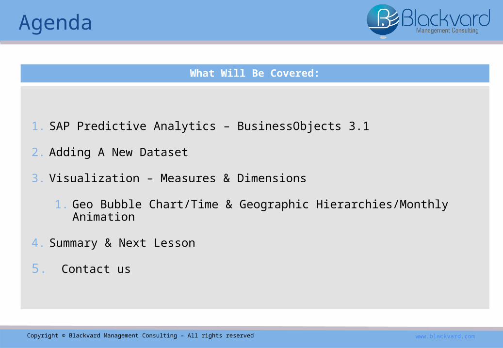
Agenda
What Will Be Covered:
1. SAP Predictive Analytics – BusinessObjects 3.1
2. Adding A New Dataset
3. Visualization – Measures & Dimensions
1. Geo Bubble Chart/Time & Geographic Hierarchies/Monthly Animation
4. Summary & Next Lesson
5. Contact us

Copyright © Blackvard Management Consulting – All rights reserved www.blackvard.com
▪In this lesson of our three part SAP BusinessObjects Predictive Analytics 3.1 course, we’ll introduce an in-depth look at the various features of SAP’s BusinessObjects, using our real world business use case of a web application crawling actual data from crime reports & arrests in a specific region during the year 2009.▪Lesson three investigates the possible real world predictions made with
this data for 2010 via SAP BusinessObjects Predictive Analytics 3.1.
SAP BusinessObjects Predictive Analytics

Copyright © Blackvard Management Consulting – All rights reserved www.blackvard.com
▪In our real world business use case, we had a web application crawl actual data from crime reports & arrests in a specific region during the year 2009.▪Crawler gathered police press announcements regarding crime, arrests, & occurrences.
Now use the data gathered from 2009 to predict crime rates & arrests for the year 2010. ▪Our data source file is in Excel spreadsheet text format; showing the data structure of
each column entry.
ID Column The Crime IdentifierTime Column Time Crime Was CommittedCity Column City Where Crime Was Committed
Street Column Street Where Crime Was Committed
Latitude Column Latitude Where Crime Was Committed
Longitude Column Longitude Where Crime Was Committed
Arrest Column Whether Or Not An Arrest Was Made
SAP BusinessObjects Predictive Analytics
Copyright © Blackvard Management Consulting – All rights reserved www.blackvard.com
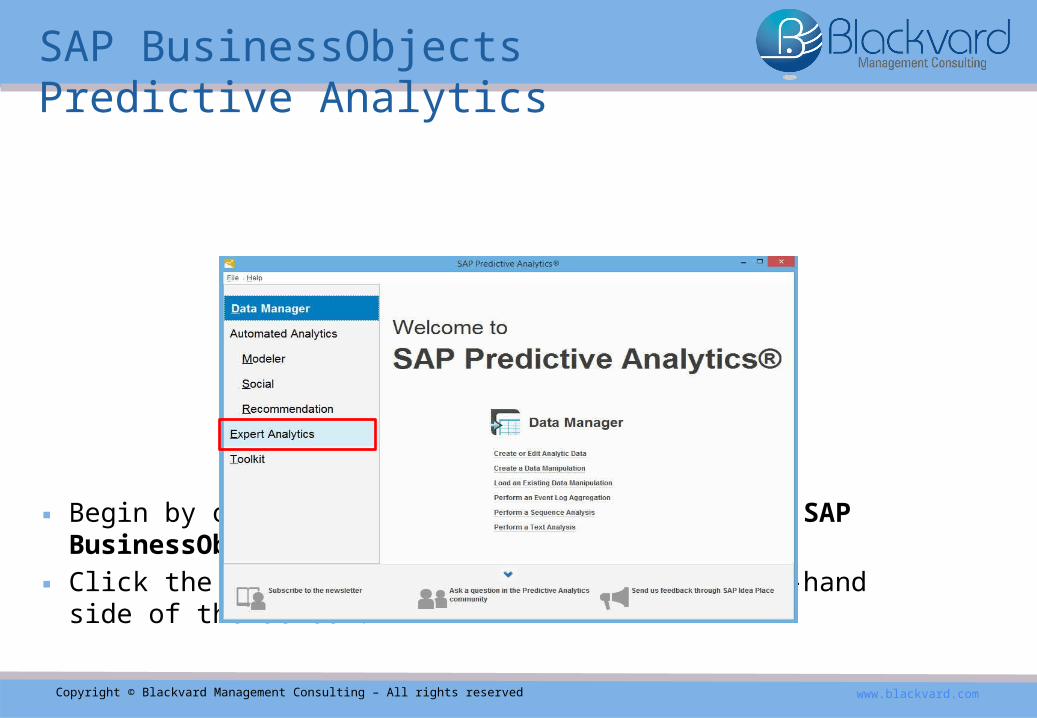
▪Begin by opening SAP Predictive Analytics 3.1 SAP BusinessObjects. ▪Click the Expert Analytics option on the left-hand side of the screen.
SAP BusinessObjects Predictive Analytics

Copyright © Blackvard Management Consulting – All rights reserved www.blackvard.com
▪The Expert Analytics screen appears.▪Click the Expert Analytics link, highlighted in the red box.
SAP BusinessObjects Predictive Analytics

Copyright © Blackvard Management Consulting – All rights reserved www.blackvard.com
▪The initial Expert Analytics home dashboard appears.
SAP BusinessObjects Predictive Analytics

Copyright © Blackvard Management Consulting – All rights reserved www.blackvard.com
▪Follow menu path File > New to add a new dataset.
SAP BusinessObjects Predictive Analytics

Copyright © Blackvard Management Consulting – All rights reserved www.blackvard.com
▪The Add new dataset screen appears.
Adding a New Dataset

Copyright © Blackvard Management Consulting – All rights reserved www.blackvard.com
▪For this lesson, begin using your Microsoft Excel crime report spreadsheet as your data source.▪Select Microsoft Excel as your data source and click the Next button.
Adding a New Dataset

Copyright © Blackvard Management Consulting – All rights reserved www.blackvard.com
▪The Add new dataset selection screen appears. ▪Upload the Microsoft Excel spreadsheet from your computer.▪Select Add Files.▪Options: Text file, Copy from Clipboard, Connect to SAP HANA, Download from SAP
Business Warehouse, Download from SAP HANA, Universe, & Query with SQL.
Adding a New Dataset

Copyright © Blackvard Management Consulting – All rights reserved www.blackvard.com
▪You’ll be prompted to select the Excel spreadsheet from your local computer. ▪Locate the Excel spreadsheet; click Open. ▪Predictive Analytics 3.1 will auto-populate the dataset for you.
Adding a New Dataset

Copyright © Blackvard Management Consulting – All rights reserved www.blackvard.com
▪The data is now displayed; all the empty dataset fields have also been auto-populated, such as Dataset Name, Sheet, Table Header Type. ▪The Excel spreadsheet values are also auto-populated for you, such as id, time, city,
street, lat, lng, & arrest. Leave all fields & values as-is.
▪Click the Create button.
Adding a New Dataset
Copyright © Blackvard Management Consulting – All rights reserved www.blackvard.com
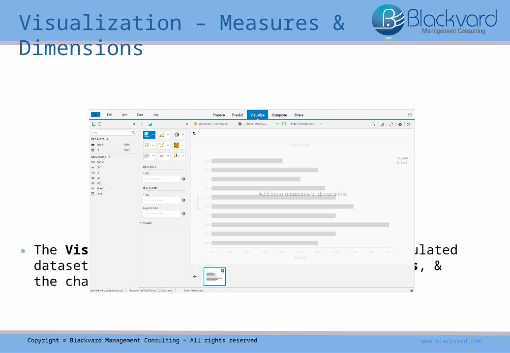
▪The Visualize screen appears, displaying the populated dataset information, such as Measures, Dimensions, & the chart to the right.
Visualization – Measures & Dimensions

Copyright © Blackvard Management Consulting – All rights reserved www.blackvard.com
▪Now create a Geo Bubble Chart to easily visualize the selected dataset information. Select the Geo Bubble Chart option. ▪Other options provided are: Bar Chart, Line Chart, Pie Chart, Scatter Plot, Heat Map,
Crosstab, Numeric Point, & Box Plot.
Visualization – Measures & Dimensions

Copyright © Blackvard Management Consulting – All rights reserved www.blackvard.com
▪The Geo Bubble Chart Visualization appears.
Visualization – Measures & Dimensions

Copyright © Blackvard Management Consulting – All rights reserved www.blackvard.com
▪In the Dimensions section, convert the lat & lng dimensions from the letters ABC into numbers.▪The import parsed the lat & lng columns as text. ▪Keep the original length without any cutting due to any data formatting
issues. So parse those columns as text & convert them into what you can calculate w/: a number.
▪Hover your cursor over lat & the Options wheel appears.▪Left-click it; the options drop-down appears. ▪Select the Convert To Numbers option.
Visualization – Measures & Dimensions

Copyright © Blackvard Management Consulting – All rights reserved www.blackvard.com
▪The ABC lat now appears below as the numbers 123 lat (2).
Visualization – Measures & Dimensions

Copyright © Blackvard Management Consulting – All rights reserved www.blackvard.com
▪Now repeat those same steps for lng.▪The ABC lng will appear as the numbers 123 lng (2).
Visualization – Measures & Dimensions
Copyright © Blackvard Management Consulting – All rights reserved www.blackvard.com
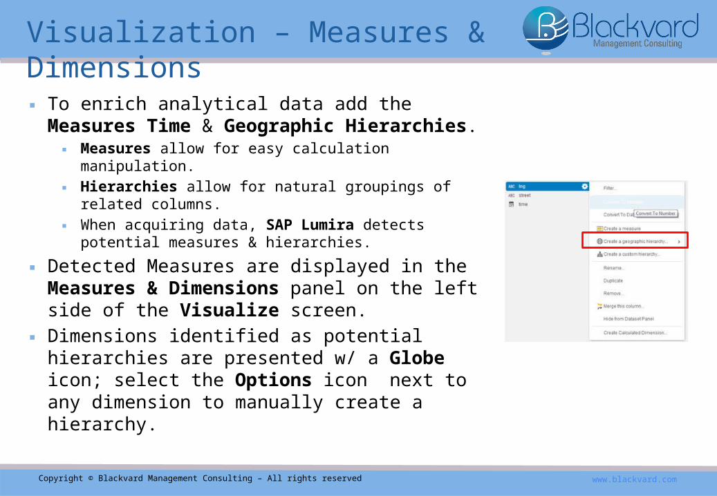
▪To enrich analytical data add the Measures Time & Geographic Hierarchies. ▪Measures allow for easy calculation manipulation. ▪Hierarchies allow for natural groupings of related columns.▪When acquiring data, SAP Lumira detects potential measures
& hierarchies.
▪Detected Measures are displayed in the Measures & Dimensions panel on the left side of the Visualize screen. ▪Dimensions identified as potential hierarchies are
presented w/ a Globe icon; select the Options icon next to any dimension to manually create a hierarchy.
Visualization – Measures & Dimensions

Copyright © Blackvard Management Consulting – All rights reserved www.blackvard.com
▪Geography & Time Hierarchies are automatically detected when a dataset is acquired; hierarchies can be custom made any time to enrich a dataset. ▪Time Hierarchies can be created on date & number columns, while Geographical Hierarchies
can only be created on columns containing values compatible w/ geography data values in the NAVTEQ database of the Predictive Analytics application. ▪Contextual menus of dimensions & column headers can be used to create hierarchies.
https://en.wikipedia.org/wiki/Navteq
Visualization – Measures & Dimensions

Copyright © Blackvard Management Consulting – All rights reserved www.blackvard.com
▪For Time Hierarchies, new columns selected as levels are added automatically to datasets.▪New time hierarchies appear on the Hierarchies Semantics tab.
▪In Geographic Hierarchies, the Geographical Data dialog displays columns that match internal data in green, columns that match ambiguously are displayed in orange, & non-matching columns are shown in red. ▪New Geography Columns that are selected as levels are automatically
added to the dataset, & the new Geography Hierarchy appears on the Measures & Dimensions panel.▪Matched levels of a geography hierarchy can be modified at any time.
Visualization – Measures & Dimensions

Copyright © Blackvard Management Consulting – All rights reserved www.blackvard.com
▪When datasets consist of latitude & longitude data, Geographic Hierarchies can be customized to use the data. ▪Predictive Analytics 3.1 creates a measure for each column
during data acquisition. ▪Please note again that latitude & longitude data must be presented numerically
(featured earlier in this presentation).
Visualization – Measures & Dimensions

Copyright © Blackvard Management Consulting – All rights reserved www.blackvard.com
▪Create a Geographical Hierarchy for the City Dimension. ▪Select the Options icon to the right of the City Dimension. ▪Follow menu path city > Create a geographical hierarchy - >
By Latitude / Longitude.
Visualization – Measures & Dimensions

Copyright © Blackvard Management Consulting – All rights reserved www.blackvard.com
▪Select the Geographical Data. ▪The Targeted Dimension should be city, the Latitude: lat (2),
the Longitude: lng (2), and the Geographical level: Other. ▪Click the Next button to continue.
Visualization – Measures & Dimensions

Copyright © Blackvard Management Consulting – All rights reserved www.blackvard.com
▪Now generate the parent levels. ▪The Geographical levels of Country, Region, and Sub-Region
should all be selected. ▪Click the Finish button.
Visualization – Measures & Dimensions

Copyright © Blackvard Management Consulting – All rights reserved www.blackvard.com
▪Again, Measures are used to enrich datasets.▪They can be created manually from a column or
dimension, or you can allow the application to detect them for you automatically in numeric column data types when a dataset is acquired.
▪Create a Measure for the city. ▪Select the Options icon to the right of the city
Dimension again. Follow menu path city > Create a measure.
Visualization – Measures & Dimensions

Copyright © Blackvard Management Consulting – All rights reserved www.blackvard.com
▪Now begin selecting your Measures & Dimensions.
Visualization – Measures & Dimensions

Copyright © Blackvard Management Consulting – All rights reserved www.blackvard.com
▪First drag & drop the city measure into the Measures Value box.
Visualization – Measures & Dimensions

Copyright © Blackvard Management Consulting – All rights reserved www.blackvard.com
▪Drag & drop the city_LongLat (geoOtherLevel) into the Dimensions Geography box.
Visualization – Measures & Dimensions

Copyright © Blackvard Management Consulting – All rights reserved www.blackvard.com
▪Date & time functions return date data or time data.▪You might need to convert the format of your source data.
▪Let’s create a Time Hierarchy. ▪Select the Options icon to the right of the Time
Dimension; follow menu path time > Create a time hierarchy… .
Visualization – Measures & Dimensions

Copyright © Blackvard Management Consulting – All rights reserved www.blackvard.com
▪The visual below appears.
Visualization – Measures & Dimensions

Copyright © Blackvard Management Consulting – All rights reserved www.blackvard.com
▪Drag & drop the Month (Month Level) Dimension into the Animation box.▪It is best to use the month option due to the limited amount of collected source
data; only a few months of data can be properly assessed. ▪The amount of days does not make sense in this case, so use Months to
animate the data.
Visualization – Measures & Dimensions

Copyright © Blackvard Management Consulting – All rights reserved www.blackvard.com
▪The below Month Animation visual now appears.▪Click the Play button at the bottom of the screen to see the monthly visual
breakdown of crime rates & events collected by the crime web crawler. ▪When you click Play, a month by month visual breakdown of various
crime activity will play on your screen like a time lapse video.
Visualization – Measures & Dimensions

Copyright © Blackvard Management Consulting – All rights reserved www.blackvard.com
▪Additional features of the Geo Bubble Chart display by hovering your mouse curser over any location & left-clicking it.▪Features include: Filter, Drill Up, Drill Down, & Exclude.
▪Drill Up & Down to see the city by Sub-Region, Region, & Country.▪As you Drill Up & Down, Measures on the left side of the screen adjust
according to the Dimensions; you can also drag & drop the desired Dimensions into the Dimensions box on the left-side of the screen.▪Reverse the drilling to cycle back upwards through the Geography Dimensions
Visualization – Measures & Dimensions

Copyright © Blackvard Management Consulting – All rights reserved www.blackvard.com
▪In this lesson, you learned about the basic features of SAP’s Predictive Analytics 3.1, including how to Add a New Dataset and how to work with Visualization techniques such as Measures & Dimensions. ▪In the next lesson, you’ll learn about the unique Prediction Properties of
Predictive Analytics 3.1, using our data from real world crime reports & arrests.
Summary & Next Lesson

Success – You Completed The Lesson!
10/10Copyright © Blackvard Management Consulting – All rights reserved www.blackvard.com
Congratulations, you completed the lesson!
In this lesson you successfully learned:
1. SAP Predictive Analytics – BusinessObjects 3.1
2. Adding A New Dataset
3. Visualization – Measures & Dimensions
a) Geo Bubble Chart/Time & Geographic Hierarchies/Monthly Animation
4. Summary & Next Lesson
5. Contact us

Copyright © Blackvard Management Consulting – All rights reserved www.blackvard.com
Want to learn more about Predictive Analytics?
Contact us today for your FREE consultation with our experts.
Email: [email protected]
Require A Consultation?


