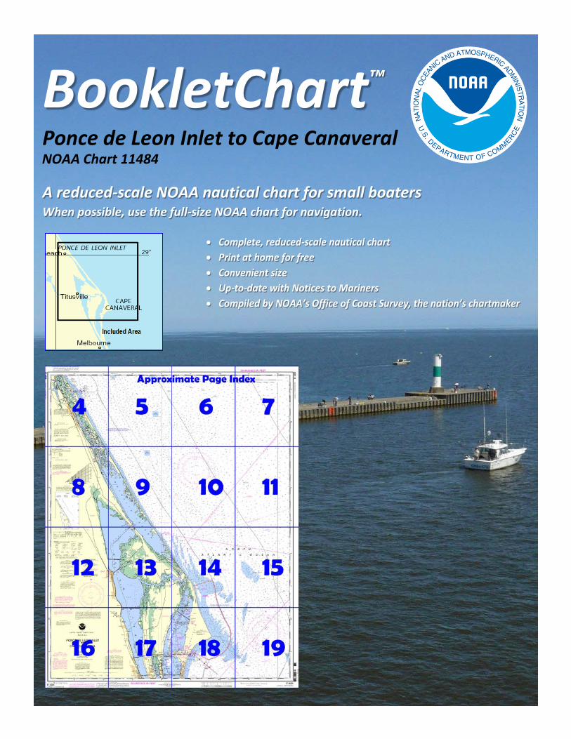
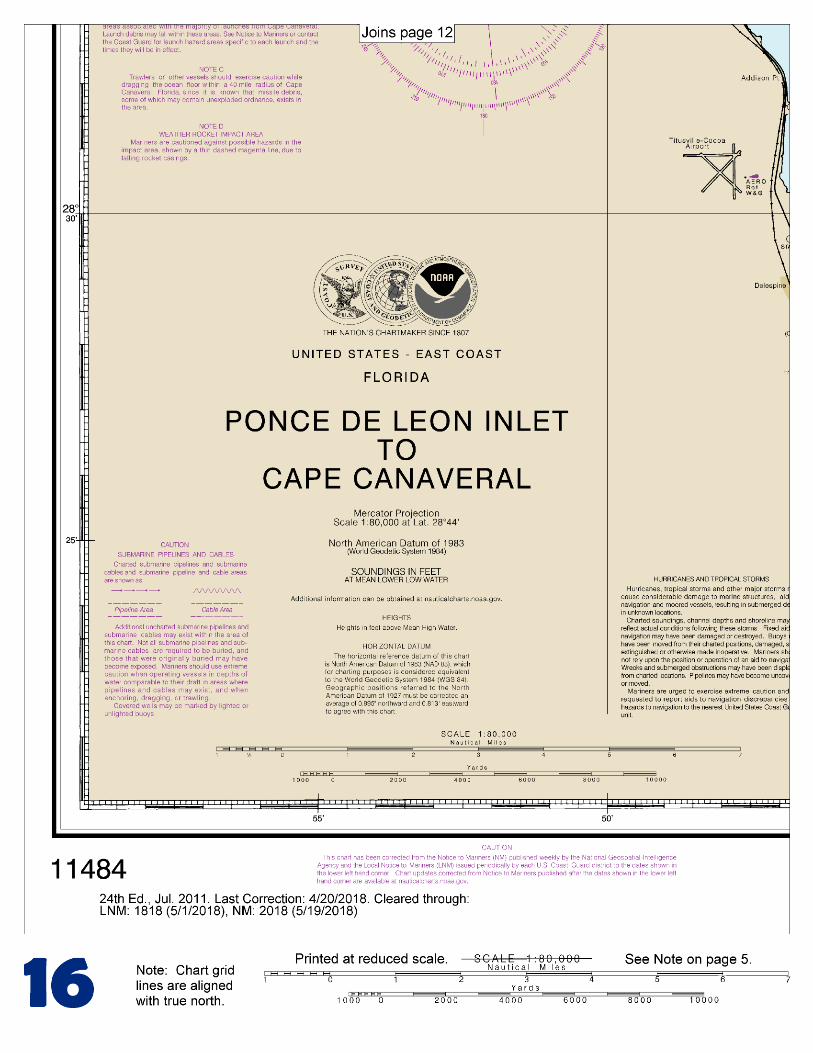
BookletChart™ Ponce de Leon Inlet to Cape Canaveral NOAA Chart 11484
A reduced-scale NOAA nautical chart for small boaters When possible, use the full-size NOAA chart for navigation.
2
Published by the National Oceanic and Atmospheric Administration
National Ocean Service Office of Coast Survey
www.NauticalCharts.NOAA.gov 888-990-NOAA
What are Nautical Charts?
Nautical charts are a fundamental tool of marine navigation. They show water depths, obstructions, buoys, other aids to navigation, and much more. The information is shown in a way that promotes safe and efficient navigation. Chart carriage is mandatory on the commercial ships that carry America’s commerce. They are also used on every Navy and Coast Guard ship, fishing and passenger vessels, and are widely carried by recreational boaters.
What is a BookletChart?
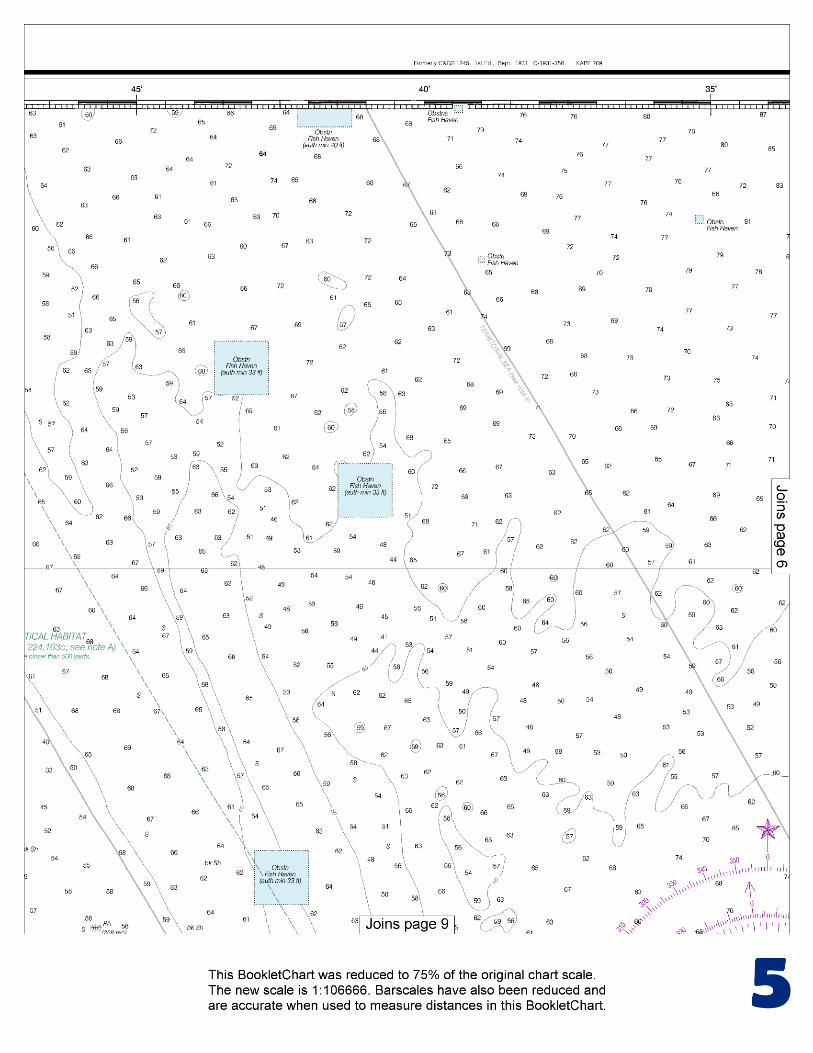
This BookletChart is made to help recreational boaters locate themselves on the water. It has been reduced in scale for convenience, but otherwise contains all the information of the full-scale nautical chart. The bar scales have also been reduced, and are accurate when used to measure distances in this BookletChart. See the Note at the bottom of page 5 for the reduction in scale applied to this chart.
Whenever possible, use the official, full scale NOAA nautical chart for navigation. Nautical chart sales agents are listed on the Internet at http://www.NauticalCharts.NOAA.gov.
This BookletChart does NOT fulfill chart carriage requirements for regulated commercial vessels under Titles 33 and 44 of the Code of Federal Regulations.
Notice to Mariners Correction Status
This BookletChart has been updated for chart corrections published in the U.S. Coast Guard Local Notice to Mariners, the National Geospatial Intelligence Agency Weekly Notice to Mariners, and, where applicable, the Canadian Coast Guard Notice to Mariners. Additional chart corrections have been made by NOAA in advance of their publication in a Notice to Mariners. The last Notices to Mariners applied to this chart are listed in the Note at the bottom of page 7. Coast Pilot excerpts are not being corrected.
For latest Coast Pilot excerpt visit the Office of Coast Survey website at http://www.nauticalcharts.noaa.gov/nsd/searchbychart.php?chart=11484.
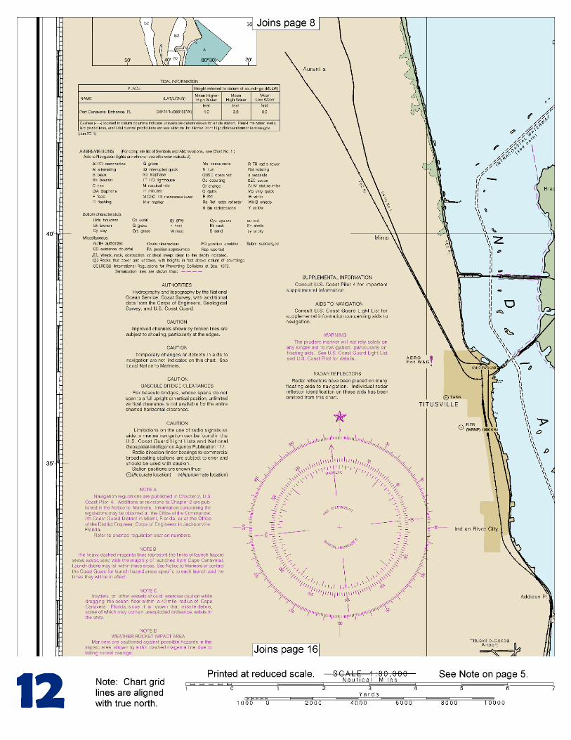
(Selected Excerpts from Coast Pilot) From Ponce de Leon Inlet to False Cape the coast is straight. The 5-fathom curve is about 0.5 mile offshore for a distance of 24 miles. Beyond this distance dangerous shoals, wrecks, and numerous fish havens will be found up to 15 miles offshore. Ponce de Leon Inlet (see chart 11485) is 53 miles southward of St. Augustine Light and 41 miles northwestward of Cape Canaveral Light. It is used by recreational and small commercial vessels bound for New Smyrna
Beach or Daytona Beach, as well as others entering for an anchorage. Ponce de Leon Inlet Light (29°04'50"N., 80°55'41"W.) is shown from a red brick conical tower on the north side of the inlet.
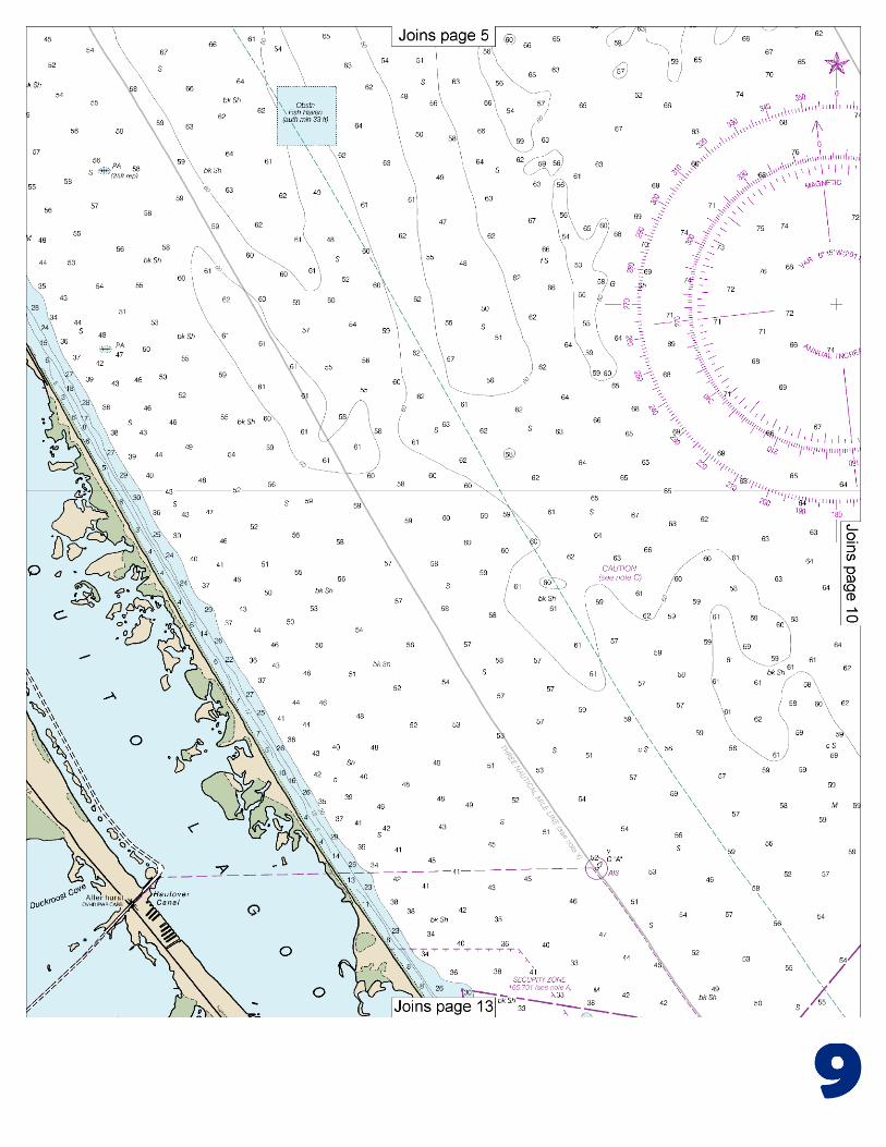
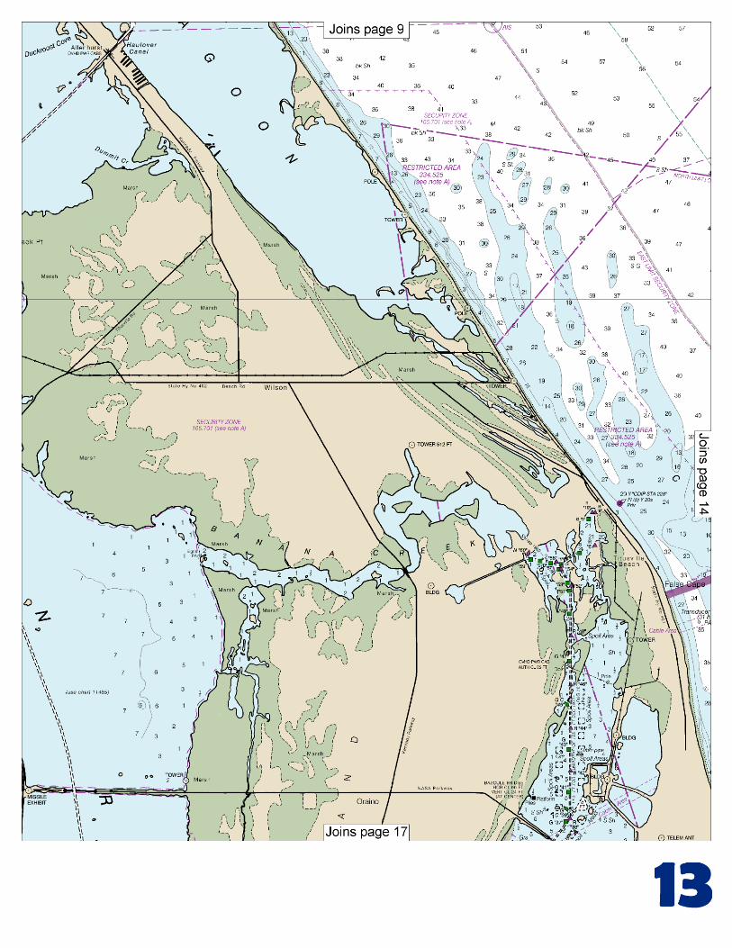
The inlet, protected at the entrance by jetties, is entered through a channel that leads over a bar and through the jetties. The outer end of the north jetty is marked by a light, and the inner end of the jetty is awash. In 2010, the controlling depth through the inlet was 14 feet. Safe navigation may also be hampered by numerous recreational fishing vessels that anchor inside the north jetty. Local knowledge and extreme caution is advised. Currents.–The current through the inlet is strong. It is reported that the average ebb is 3 knots, however, this can increase to 5 or 6 knots with southeasterly winds. High water occurs about the same time as at Mayport. Inside the inlet, three channels lead to the Intracoastal Waterway; northward through Halifax River, westward through Rockhouse Creek, and southeastward through Indian River North. The channels through Halifax River and Indian River North are marked by buoys. In 2010, the midchannel controlling depth was 5 feet; thence in 1986, the midchannel controlling depth in Rockhouse Creek was 7 feet; thence in 2010, the controlling depth was 9 feet to the Intracoastal Waterway by way of Indian River North. Ponce de Leon Inlet Coast Guard Station is on the south side of the entrance to Ponce de Leon Inlet. Supply and repair facilities inside the inlet are described in chapter 12. The Intracoastal Waterway is just inside the entrance to Ponce de Leon Inlet, passing through Halifax River from the north and Indian River North from the south. About 10 miles southward of Ponce de Leon Inlet is Turtle Mound, a prominent hill 50 feet high. It is under the protection of the Florida State Historical Society. The original Indian name was Mount of Surruque. It was charted on Florida maps in 1564. Spanish galleons stopped here for repairs, wood, and water. Eldora is a fishing camp 11.5 miles southward of Ponce de Leon Inlet. False Cape, about 7.5 miles northward of Cape Canaveral Light, is the name given to a small part of the coast which it resembles when seen from seaward. The John F. Kennedy Space Center and the Cape Canaveral Air Force Station occupy most of Canaveral Peninsula and Merritt Island, the large land areas between the ocean and the Banana and Indian Rivers, from Mosquito Lagoon on the north to Port Canaveral on the south. The huge Vehicle Assembly Building at the center, said to be one of the world’s largest buildings, is visible far from shore. When closer in, other buildings and the mobile service towers at the cape are also conspicuous from all directions. A restricted area has been established in the navigable waters contiguous to the area offshore of the John F. Kennedy Space Center. (See 334.525, chapter 2, for limits and regulations.) Trawlers or other vessels should exercise caution while dragging the ocean floor within a 40-mile radius of Cape Canaveral because missile debris containing unexploded ordnance exists in the area. Cape Canaveral, where the coast makes a sharp bend westward, is low and sandy. The shore in the vicinity of the cape is constantly moving eastward. Cape Canaveral Light (28°27'37"N., 80°32'36"W.), 137 feet above the water, is shown from a white and black horizontally banded conical tower 1 mile inshore from the cape.
U.S. Coast Guard Rescue Coordination Center 24 hour Regional Contact for Emergencies
RCC Miami Commander
7th CG District (305) 415-6800 Miami, FL

G
NOAA’s navigation managers serve as ambassadors to the maritime community. They help identify navigational challenges facing professional and recreational mariners, and provide NOAA resources and information for safe navigation. For additional information, please visit nauticalcharts.noaa.gov/service/navmanagers
To make suggestions or ask questions online, go to nauticalcharts.noaa.gov/inquiry. To report a chart discrepancy, please use ocsdata.ncd.noaa.gov/idrs/discrepancy.aspx.
Lateral System As Seen Entering From Seaward on navigable waters except Western Rivers
PORT SIDE
ODD NUMBERED AIDS
GREEN LIGHT ONLY
FLASHING (2)
PREFERRED CHANNEL
NO NUMBERS – MAY BE LETTERED
PREFERRED CHANNEL TO
STARBOARD
TOPMOST BAND GREEN
PREFERRED CHANNEL
NO NUMBERS – MAY BE LETTERED
PREFERRED CHANNEL
TO PORT
TOPMOST BAND RED
STARBOARD SIDE
EVEN NUMBERED AIDS
RED LIGHT ONLY
FLASHING (2)
FLASHING FLASHING
OCCULTING GREEN LIGHT ONLY RED LIGHT ONLY OCCULTING QUICK FLASHING QUICK FLASHING
ISO COMPOSITE GROUP FLASHING (2+1) COMPOSITE GROUP FLASHING (2+1) ISO
"1"
Fl G 6s
G "9"
Fl G 4s
GR "A"
Fl (2+1) G 6s
RG "B"
Fl (2+1) R 6s
"2"
Fl R 6s
8
R "8"
Fl R 4s
LIGHT
G
C "1"
LIGHTED BUOY
G
"5"
GR
"U"
GR
C "S"
RG
N "C"
RG
"G"
LIGHT
6
R
N "6"
LIGHTED BUOY
R
"2
"
CAN DAYBEACON
CAN NUN NUN
DAYBEACON
For more information on aids to navigation, including those on Western Rivers, please consult the latest USCG Light List for your area.
These volumes are available online at http://www.navcen.uscg.gov
Navigation Managers Area of Responsibility
Northeast
Lt. Meghan McGovern
Northwest and
Pacific Islands
Crescent Moegling
Great Lakes Region
Tom Loeper
Chesapeake and
Delaware Bay
Steve Soherr
California
Jeff Ferguson
[email protected] Mid-Atlantic
Lt. Ryan Wartick
Alaska
Lt. Timothy M. Smith
Western Gulf Coast
Alan Bunn
Central Gulf Coast
Tim Osborn
[email protected] South Florida
Puerto Rico
U.S. Virgin Islands
Michael Henderson
Southeast
Kyle Ward
2
2 C U 5
1


VHF Marine Radio channels for use on the waterways:Channel 6 – Inter-ship safety communications.Channel 9 – Communications between boats and ship-to-coast.Channel 13 – Navigation purposes at bridges, locks, and harbors.Channel 16 – Emergency, distress and safety calls to Coast Guard and others, and to initiate calls to other
vessels. Contact the other vessel, agree to another channel, and then switch.Channel 22A – Calls between the Coast Guard and the public. Severe weather warnings, hazards to navigation and safety warnings are broadcast here.Channels 68, 69, 71, 72 and 78A – Recreational boat channels.
Getting and Giving Help — Signal other boaters using visual distress signals (flares, orange flag, lights, arm signals); whistles; horns; and on your VHF radio. You are required by law to help boaters in trouble. Respond to distress signals, but do not endanger yourself.
EMERGENCY INFORMATION
Distress Call Procedures
• Make sure radio is on.• Select Channel 16.• Press/Hold the transmit button.• Clearly say: “MAYDAY, MAYDAY, MAYDAY.”• Also give: Vessel Name and/or Description;Position and/or Location; Nature of Emergency; Number of People on Board.• Release transmit button.• Wait for 10 seconds — If no responseRepeat MAYDAY call.
HAVE ALL PERSONS PUT ON LIFE JACKETS!
This Booklet chart has been designed for duplex printing (printed on front and back of one sheet). If a duplex option is not available on your printer, you may print each sheet and arrange them back-to-back to allow for the proper layout when viewing.
QR
Quick ReferencesNautical chart related products and information - http://www.nauticalcharts.noaa.gov
Interactive chart catalog - http://www.charts.noaa.gov/InteractiveCatalog/nrnc.shtmlReport a chart discrepancy - http://ocsdata.ncd.noaa.gov/idrs/discrepancy.aspx
Chart and chart related inquiries and comments - http://ocsdata.ncd.noaa.gov/idrs/inquiry.aspx?frompage=ContactUs
Chart updates (LNM and NM corrections) - http://www.nauticalcharts.noaa.gov/mcd/updates/LNM_NM.html
Coast Pilot online - http://www.nauticalcharts.noaa.gov/nsd/cpdownload.htm
Tides and Currents - http://tidesandcurrents.noaa.gov
Marine Forecasts - http://www.nws.noaa.gov/om/marine/home.htm
National Data Buoy Center - http://www.ndbc.noaa.gov/
NowCoast web portal for coastal conditions - http://www.nowcoast.noaa.gov/
National Weather Service - http://www.weather.gov/
National Hurrican Center - http://www.nhc.noaa.gov/
Pacific Tsunami Warning Center - http://ptwc.weather.gov/
Contact Us - http://www.nauticalcharts.noaa.gov/staff/contact.htm
NOAA’s Office of Coast Survey The Nation’s Chartmaker
For the latest news from Coast Survey, follow @NOAAcharts
NOAA Weather Radio All Hazards (NWR) is a nationwide network of radio stations broadcasting continuous weather information directly from the nearest National Weather Service office. NWR broadcasts official Weather Service warnings, watches, forecasts and other hazard information 24 hours a day, 7 days a week. http://www.nws.noaa.gov/nwr/


