Scholars' Mine Scholars' Mine
Masters Theses Student Theses and Dissertations
1965
Petrology and mineralogy of the "Old Workings Area," El Salvador, Petrology and mineralogy of the "Old Workings Area," El Salvador,
Chile Chile
Bertis James Vander Schaaff
Follow this and additional works at: https://scholarsmine.mst.edu/masters_theses
Part of the Geology Commons
Department: Department:
Recommended Citation Recommended Citation Vander Schaaff, Bertis James, "Petrology and mineralogy of the "Old Workings Area," El Salvador, Chile" (1965). Masters Theses. 5240. https://scholarsmine.mst.edu/masters_theses/5240
This thesis is brought to you by Scholars' Mine, a service of the Missouri S&T Library and Learning Resources. This work is protected by U. S. Copyright Law. Unauthorized use including reproduction for redistribution requires the permission of the copyright holder. For more information, please contact [email protected].

>
I - ! !
PETROlOGY AND MINERAlOGY OF THE "OLD WJRKINGS
AREA," EL SALVADOR, CHILE I o
BY
BERTIS J~ANDER SCHAAFF 'i~I
A
THESIS
submitted to the faculty of
THE UNIVERSITY OF MISSOURI AT ROLLA
in partial fulfillment of the requirements for the
Degree of
.MASTER OF SCIENCE IN GEOlOGY
Rolla, Missouri
1965
Approved by
Q - 71.._. }j ,.;4-dJ_ /J.7~ _(advisor)
~/Y51A~v ...

TABLE OF CONTENTS
ABSTRACT •••••••••••• . . . . . . . . . . . . . . . . . . . . . . . . . . . . . . . . LIST OF FIGURES •••• . . . . . . . . . . . . . . . . . . . . . . . . . . . . . . . . . LIST OF PLATES •••••••• . . . . . . . . . . . . . . . . . . . . . . . . . . . . . .
I.
II.
III.
IV.
INTRODUCTION •••••••••••••••••• . . . . . . . . . . . . . . . . A. Purpose of Investigation •• . . . . . . . . . . . . . . . . B. location and Size of Area. . . . . . . . . . . . . . . . . c. Topography •••••••••••••• . . . . . . . . . . . . . . . . . . D. Climate and Vegetation •• . . . . . . . . . . . . . . . . . . E. Culture .•••••.•..••.•••.••.•..• . . . . . . . . . . . F. Field and Laboratory Procedure. . . . . . . . . . . . G. Acknowledgements ••••••••• . . . . . . . . . . . . . . . . . GENERAL GEOLOGIC SETTING •••• . . . . . . . . . . . . . . . . . . A. Previous Investigations ••••• . . . . . . . . . . . . . . B. Petrology and Age Relations. . . . . . . . . . . . . . . c. Structure ••••••••••••••••• . . . . . . . . . . . . . . . . PORPHYRY-TYPE ORE DEPOSITS ••••••••••••••••••••
A.
B.
c.
D •
E.
F.
Mineralogy •••••• . . . . . . . . . . . . . . . . . . . . . . . . . . Host Rock Types •••••••••••••••••••••••••••
Structure •••••••••••••••• . . . . . . . . . . . . . . . . . Hydrothermal Alteration •• • • • • • • • • • • • • • • • • •
Oxidation and Supergene Enrichment ••••
Factors ~bich Influence the Degree of Supergene Enrichment ••••••••••••••••
. . . .
. . . . EL SALVAOOR 110LD w::>RKINGS AREA 11
• . . . . . . . . . . . . . . A. Petrography and Petrology ••• . . . . . . . . . . . . . .
1. Rhyolite Pebble Conglomerate. • • • • • • • • •
Page i
ii
iii
1
1
1
3
4
5
7
9
10
10
11
12
15
15
16
17
17
18
21
23
23
23

v.
VI.
VITA.
B.
2. Rhyolite Porphyry. . . . . . . . . . . . . . . . . . . . . . 3. Andesite •••••••• . . . . . . . . . . . . . . . . . . . . . . . 4. Quartz Porphyry. . . . . . . . . . . . . . . . . . . . . . . . 5. Tourmaline-Bearing Breccia. . . . . . . . . . . . . Ores • •••••••••••••••••••••• • • • • • • • • • • • • • • • •
1.
2.
3.
4.
Primary Sulphide Minerals. • • . . . . . . . . . . . Secondary Sulphide
Secondary Sulphate Copper Minerals.
MQscellaneous •••••
Minerals. . . . . . . . . . . . and Silicate . . . . . . . . . . . . . . . . . . . . . . . . . . . . . . . . . . . . . . . . . .
SUMMARY AND CONCLUSIONS •• • • • • • • • • • • • • • • • • • • • • • •
BIBLIOGRAPHY•••••••••••••••••••••••••••••••••••
. . . . . . . . . . . . . . . . . . . . . . . . . . . . . . . . . . . . . . . . . . . . . . . .
Page 26
29
30
38
41
44
47
48
49
53
56
58
ABSTRACT
The "Old Workings Area, .. so called for its early
mining by the Incas, is located 4~ miles northeast of
the Bl Salvador Porphyry copper deposit, the third
largest copper producer in Chile. The area mapped in
this study is shown to consist of rhyolite pebble con
glomerate, two volcanic flows, andesite and rhyolite
porphyry, and two intrusions, quartz porphyry and
tourmaline-bearing breccia.
Petrographic study of surface and drill core rock
samples confirms the field nomenclature used for the
five rock types. All of the rock types are altered, but
the quartz porphyry and andesite are the most intensely
altered. Both hydrothermal and weathering actions have
contributed to the alteration.
i
Ore microscopic investigations of selected polished
surfaces showed that pyrite, chalcopyrite, and molybdenite
are the primary sulphides in the "Old Workings Area."
The secondary copper minerals, chalcocite and covellite,
replace the primary sulphide minerals. At the surface the
copper sulphides are oxidized to brochanthite, chrysocolla,
and antlerite. Hematite, hausmannite, and braunite locally
are present as fracture coatings.

ii
LIST OF FIGURES
Page Figure 1. Geographic location of area................. 2
Figure 2. Schematic cross-section of a typical oxidized and enriched porphyry-type deposit. • . . . . . . . . . . . . . . . . . . . . . . . . . . . . . . . . . 20
Figure 3. Geologic Map of "Old Workings Area"......... 24

LIST OF PLATES
Plate Ia. Photomicrograph of rhyolite pebble conglomerate showing a rounded pebble in a cementing matrix of secondary epidote, orthoclase, plagioclase, and
iii
Page
clay. Nicols crossed. (30X)............. 28
Plate Ib. Photomicrograph of rhyolite porphyry exhibiting porphyritic texture. Phenocrysts of plagioclase and quartz in a matrix of orthoclase, quartz, plagioclase and secondary epidote. Nicols crossed. {30X) ••••••••••••••••••••••••••• 28
Plate IIa. Photomicrograph of andesite exhibiting clay (dark gray) and sericite (light gray) formed by alteration of plagioclase and other minerals. Crossed nicols. (30X) .•.•.•.•.•••.••••••.•••••... 32
Plate IIb. Photograph showing intense alteration (light gray) of andesite (medium gray).... 32
Plate Ilia. Photograph showing abundant fractures in andesite which have been filled by secondary quartz •••••••••••••••••••••••••• 34
Plate IIIb. Photograph of intensely fractured andesite. Dark areas are caused by secondary iron oxide •••••••••••••••••••••• 34
Plate IV;., Photograph showing contact of quartz porphyry (left) and andesite {right). Alteration and mineralization are
Plate Va.
prevalent along the contact ••••••••••••••• 36
Photomicrograph of quartz porphyry showing two subhedral quartz phenocrysts {black, bottom) and a plagioclase phenocryst ghost (top) now altered to sericite and clay. The phenocrysts are set in a fine-grained groundmass. Note the embayment of one quartz phenocryst. Also compare the size of the groundmass of this Plate and Plate Vb. Crossed nicols. ( 30X) • • • • • • • • • • • • • • • • • • • • • • • • • • • • • • • • • • • • • 40

Plate Vb. Photomicrograph of quartz porphyry obtained in a diamond drill hole. Note the larger grain size of the orthoclase and quartz in the groundmass of this specimen as contrasted to that quartz porphyry above which was collected on the surface. Crossed
iv
Page
nicols. (30X) ••••.•...••..........•.•.•..• 40
Plate VIa. Photograph of tourmaline-bearing breccia showing quartz porphyry and andesite breccia fragments (light gray) cemented by a quartz-tourmaline matrix (dark gray).. 43
Plate VIb. Photomicrograph showing tourmaline crystals (medium gray, long) and quartz grains (light gray) cementing breccia fragments (dark gray). Crossed nicols. (30X)...................................... 43
Plate VIIa. Photomicrograph of quartz porphyry showing abundant pyrite and one grain chal-cocite. Reflected light. ( 30X) • • • • • • • • • • • 46
Plate VIIb. Photomicrograph of rhyolite pebble conglomerate showing that chalcopyrite formed after pyrite. Reflected light. (30X)..... 46
Plate VIIIa. Photomicrograph of ice cake texture between pyrite and chalcopyrite, indicating that chalcopyrite has replaced pyrite. Reflected light. (30X)........... 52
Plate VIIIb. Photomicrograph of copper pitch showing hausmannite surrounded by braunite. Reflected light. (30X) •••••••••••••••••••• 52

1
I. INTRODUCTION
A. Purpose of Investigation
The purpose of this investigation was to map and study
an area three miles northeast of El Salvador, Chile. Geo
logic mapping, determination of the relationships between
the rock units, and the collection of representative speci
mens were the main activities in the field. The determina
tion of the lithologic types, primary sulphide mineralogy
and secondary supergene mineralogy constituted the principal
emphasis in the laboratory portion of this investigation.
B. location and Size of Area
The area mapped for this investigation lies in Atacama
Desert, in Atacama Province, about seventy-five miles east
of the coastal town of Chanaral and twenty miles north of
Potrerillos (see figure 1). It is about four and one half
miles northeast of Indio Muerto Peak, beneath which the El
Salvador deposit is mined.
The mapped area is nearly rectangular in shape, with
a length of about 1250 meters and a width of about 750
meters. In the central portion of the area, copper was
mined possibly as early as pre-Inca times. These workings
are locally referred to as the "Old Workings," and for the
purpose of this study, the entire mapped area will be
referred to as the "Old Workings Area."

PAC IC
SCALE B 59 MILES
CERRO BRAVO
•
FIG. 1. GEOGRAPHIC LOCATION OF "OLD WORKINGS AREA"
2
0 69
\
0 27 26
lQQ

c. Topography
The area is characterized by a rather mature topo
graphy, with rounded forms. The entire region, as seen
from the air, appears to be a well developed normal stream
relief partly buried under alluvial fans. Many isolated
ridges and small hillocks, partly covered by debris due to
mechanical weathering of the rock, emerge from beneath the
alluvium.
The maximum elevation is 2805 meters and the minimum
elevation is 2615 meters above sea level. The maximum
relief is 190 meters, but the average relief is 25 meters
between the gravel washes and the ridges.
Two gravel washes form the boundaries of the area
mapped~ one forms the northern and eastern borders and
the other forms the western border. The southern border
is marked by the highest hill in the area, which has an
elevation of 2805 meters above sea level.
3
Four ridges extend from the highest point, the highest
point being on a ridge extending northwest into the area.
The crests of these ridges slope to the northwest. The two
gravel covered washes converge at the end of the western
most ridge.
The ridges generally are controlled by the quartz por
phyry while the valleys are underlain by andesite. Three
tourmaline volcanic breccia pipes form ridges. The rhyolite
and the conglomerate are exposed along the western flank of
the northwestern ridge just east of the western border. The

conglomerate also outcrops in the extreme northern part of
the area.
D. Climate and Vegetation
4
The arid climate of the Old Workings Area is charac
terized by an average annual rainfall of four tenths of an
inch. This meager rainfall occurs principally during the
winter months and the water supplies for the remainder of
the year are dependent on this seasonal precipitation. It
quickly permeates the surface gravels and reappears as
springs where the water encounters impermeable shales at
lower elevations. Rainfall reaching the Ola River provides
most of the water for the El Salvador mine and mill and the
Potrerillos smelter operations. A pipeline from the dam on
the Ola River, at an elevation of 11,650 feet above sea
level, transports that water down to El Salvador and Potrer
illos at an elevation of 9,500 feet above sea level.
The Old Workings Area lies approximately 200 miles
south of the Tropic of Capricorn. The temperature ranges
from just below freezing to moderate temperatures during
the winter months, May to September, and from moderate
temperatures into the ninties during the summer months.
Field work can be undertaken throughout the year.
The prevailing winds usually are from the west. The
area is characterized by high winds, gaining velocities as
high as sixty miles per hour. Winds commonly reach an
average of fifteen to twenty miles per hour.

As a result of the prevailing winds, cumulus clouds
occasionally reach as far inland as El Salvador and
frequently bring precipitation with them. The clouds
fbrrn at the edge of the Andes Mountain Range and drop
most of the precipitation as they rise up to pass over
the higher peaks.
5
Sparse vegetation is characteristic of the area. Sage
brush, greasewood, and many varieties of cactus are the only
plants in the desert. Trees and plants foreign to the area
have been planted about the homes in the towns of El Salvador
and Potrerillos.
E. Culture
The Atacama Province is sparsely populated. The main
centers of population are the mining camps of El Salvador,
Potrerillos, Llanta, and Barquito, but a few people live in
small villages along the only major road which connects
Botrerillos to the coastal town of Chanaral. This major
road is paved only from El Salvador to Llanta. The streets
in El Salvador, Potrerillos and Llanta also are paved. All
the other roads in the area are dirt, except those in the
coastal towns.
Bus service is available daily along the partly paved
road from Potrerillos to the coast, where bus connections
can be made to other points along the coast. A chartered
bus line serves to transport the workers to the plant and
El Salvador mine.

6
There are two railroads in the area, one owned by the
Andes Mining Company and the other owned by the Chilean
Government. The railroad owned by the mining company con
nects Potrerillos to Pueblo Hundido and is operated for the
purpose of freight only. The Chilean National Railway
operates service from the Pueblo Hundido to all other parts
of Chile. The mining company has an agreement with the
Chilean Government to use : 'iti:F tracks to haul copper to
the company coastal town of Barquito.
In the early days, cars were mounted on train wheels
and converted to track cars, the steering wheel becoming the
brake. It was a dusty days trip from Barquito to Pbtrer
illos in those days. The track cars are still used, however,
since the roads are good, but not as frequently.
The area is served by a commercial airline, the Ladeco
Airline, which connects Botrerillos and El Salvador with
Santiago, Antofagasta, and Calarna. A small paved airport
at El Salvador serves two privately owned aircraft and the
Ladeco DC-3 1 s when weather conditions do not permit landings
at Potrerillos. By air, Antofagasta is only one and a half
hours, Calarna only two and one half hours and Santiago, the
capital of Chile, is only two and a half hours from Potrer
illos.
The area bears witness to the early presence of the
Inca•s, who inhabited much of Chile in the fifteenth, six
teenth and seventeenth centuries. An old Inca trail crosses
the flat pampa to the south-west of the El Salvador mill.

The well worn trail continues from the coast into the
mountains. The trail is still easily recognized due to
the fact that it is about twwive inches deep. An old
burial ground, located about one mile north-east of El
Salvador, has been the source of many artifacts. Many
7
of the old pits and tunnels of the old workings are
believed to have been worked by the Incas.. The diggings
and tunnels follow the rich veins of chrysocola. North
east of the old workings, foundation remnants, slag, and
piles of low grade ore have been referred to the activities
of the Inca•s.
F. Field and Laboratory Procedure
The geodogy of "The Old Workings Area 11 was mapped by
triangulation and tape and compass and plotted on a Lase
topographic map having a scale of 1:5000. Two claim
markers in the area, HR-1 and PP, previously surveyed,
served as triangulation points. Seven old drill holes,
which were flagged to make them more easily identifiable
at a distance, were used as subsidiary base points. The
locations of these drill holes were determined by triangu
lation and plotted by tape and compass traverses to the
nearest claim marker.
After completing the geologic map, surface samples
were collected from fifty-four localities, selected on the
basis of geologic mapping.

8
Drill cores from six diamond drill holes were examined
and of these, drill hole number 4 (251.1 meters deep),
drill hole number 6 (385.47 meters deep), and drill hole
number 9 (376.67 meters deep), were selected for sampling.
Tourmaline-bearing breccia, quartz porphyry, and andesite
were sampled from diamond drill hole number 4. The richest
copper mineralization in the area was intersected and
sampled in diamond drill hole number 6. Tourmaline-bearing
breccia was sampled from diamond drill hole number 9. All
three drill holes sampled exhibited a marked increase in
pyrite content downward.
Sixty thin sections of drill core and surface specimens
were prepared by the writer using an Ingram Ward thin sec
tion cut-off saw and an thin section grinder. Twenty
polished sections were mounted in leucite, bakelite, and
plastic. The writer found one quarter micron diamond,
alumina, and finally magnesia produced the best polish.
The sections were examined with petrographic and ore
microscopes to determine the texture and mineralogy of each
specimen. Plagioclase composition was determined by the
universal stage Rittman Zone Method Plagioclase Determina
tion. This method depends upon a precise measur-ement of
angle of extinction of plagioclase twinning lamella. The
measured angles placed on curves given by Emmons (1943)
determine the plagioclase compositdoo.
Orthoclase present in thin sections was determined by
staining. The cover slide was removed along with the excess

balsam and cadex. Hydrofluoric acid was spread on the
section with a brush and allowed to remain on the slide
for a period of fifteen to twenty seconds. The slide was
then soaked in sodium cobalt-nitrite for twenty to thirty
minutes. The slide is then washed in water and if ortho
clase is present it is stained yellow. The staining must
9
be performed with rubber gloves under a hood, for the hydro
fluoric fumes and liquid are extremely dangerous.
All grain size measurements were calculated by averaging
the width and length of each grain or crystal except where
noted otherwise.
G. Acknowledgements
The writer wishes to thank Dr. Richard D. Hagni for
directing the thesis and for his suggestions, careful
assistance and friendly guidance. The writer also is in
debted to the people employed at Andes Copper Mining Com
pany, El Salvador, Chile and Potrerillos, Chile, especially
to Dr. Frank Trask, chief geologist Andes Copper Mining
Company, for suggesting the thesis and for field guidance.
Gratitude is expressed to Mr. and Mrs. W. J. Bennett
and other residents of Potrerillos and El Salvador mining
camps for their warm hospitality.

10
II. GENERAL GEOLOGIC SETTING
A. Previous Investigations
Previous investigations in Chile are mainly in Spanish
and German. Three papers in English pertinent to this
thesis and one dealing with the El Salvador area are dis
cussed below.
Cristi (1959) described the stratigraphy and general
geology in the chapter on Chile in the Geological Society
of America Memoir dealing with all of South America. The
purpose of this memoir is to supplement the geologic map
of South America. Cristi subdivides the northern part of
Chile, the El Norte Grande, from the Peruvian border to
Latitude 27 south, into three physiographic units. These
units are: the coast range, the Pampa del Tamaragugal, and
the Andes.
Harrington (1961) discussed the stratigraphy of the
Antofagasta and Atacama Provinces in northern Chile, north
of Latitude 26 south. While Harrington discussed the igneous
and metamorphic rocks, he was principally interested in the
sedimentary rocks and the oil content. He emphasized the
~evity of geological study and the fact that much of the
geology, except for stratigraphy of some areas, is imper
fectly known.
Kents (1963) studied numerous breccia pipes throughout
South America and attributed their formation to hydrothermal
activity.

11
Swayne and Trask (1960) are the only authors to
publish in English on the El Salvador area. They gave a
detailed account of the stratigraphy, structure, mineralogy
and alteration in the area immediately surrounding the El
Salvador mine. The El Salvador mine, which is operated by
the Andes Copper Mining Company, a wholly owned subsiderary
of the Andaconda Company, is a porphyry-type deposit. All
of the ore comes from the enriched layer which is princi
pally chalcocite, but also has chalcopyrite, cuprite, and
native copper. The ore minerals are disseminated mainly
in fine-grained granodiorite and granodiorite porphyry.
The igneous body intrudes andesite and rhyolite.
The following sections on petrology and structure are
based upon the references cited above.
B. Petrology and Aq~ aelations
The consolidated rock types exposed in the El Salvador
area consist of older extrusives and younger intrusives.
The extrusives are subdivided into three cycles. The oldest
of these began in the middle Triassic and lasted into the
upper Triassic. The rock types of this cycle are kerato
phyric varieties of slightly oversaturated soda trachytes,
but rhyolite and andesite are intercalated with the kerato
phyres, especially near the top of the sequence.
The second cycle of extrusives began during the late
Jurassic. They are mainly andesites, which are called
pophyrites in Chile, following the German nomenclature for

pre-Tertiary andesites. Much basalt and some rhyolite is
associated with these andesites.
12
The vulcanites of the third cycle are interbedded with
sandstone of both continental and marine origin. Their age
is hard to determine for they form sills and laccoliths as
well as flows.
In the Chanaral-Taltal area, ninty miles to the west
of El Salvador, along the west coast of Chile, thick kera
tophyres and andesite flows and tuffs are intercalated with
grayish green and dark gray shales. These rocks are younger
than the extrusives of the three cycles discussed above, but
are absent from the El Salvador area.
The younger intrusives, which are exposed throughout
the El Salvador area, consist of granodiorite, granodiorite
porphyry, diorite porphyry and quartz porphyry. These por
phyries are believed to be Cretaceous.
The breccia pipes discussed by Kents (1963) are younger
than the porphyry group.
c. Structure
The tectonic structure of the El Salvador and "Old Work
ings Area," is complex regionally, but simple locally. Jur
assic sediments and Tertiary andesites form an imbricate
structure with westward dipping reverse faults. Since the Jur
assic beds also dip to the west, the reverse faults are not al
ways easily distinguished. The Jurassic sediments were warped
into broad regional folds prior to the reverse faulting.

13
Gentle monoclinal folds display a broad dome structure.
While Jurassic sediments are exposed on the western and
northwestern limb of the dome, the eastern limb is concealed
by a dry salt lake called the Salar de Pedernales. The
core of the dome is formed by pre-Jurassic granite, and its
axis strikes north-northeast. The dome appears to be cut
longitudinally by a vertical fault which marks the eastern
limit of the granite. This fault brings the granite into
contact with Tertiary andesites to the east.
The Pedernales Salar on the east limb is famous for
its oil seeps which were drilled for water. The seeps are
arranged in a straight line across the salar or salt lake.
The artificial wells have been enlarged many years ago in
an attempt to increase the oil seepage.
The "Old Workings Area" lies in the Principal Cordillera,
which consists of more or less parallel ridges, separated by
wide longitudinal valleys filled with wash from the surround
ing mountains. The westernmost· ridge rises steeply above
the coast to reach an average elevation of 4200 feet above
sea level. The coast is characterized by longitudinal
faults of great vertical displacement. These faults are
responsible for the subvertical cliffs along the coast and
correspond to the Coast Range of Cristi (1959). That these
faults are still active is indicated by the frequency of
the earthquakes in their vicinity.
The longitudinal valleys cut through the parallel
ridges along the coast and provide an easy access to the

14
pampa region on which El Salvador is located. Just east of
the El Salvador, the main chain of the Andes rise to form
the great volcanic ridge.
The local structure of El Salvador is characterized
by volcanic flows which subsequently were arched, folded
and faulted. Overthrusting of these deformed rocks took
place during the main Andian uplift in Cenozoic time.
Fracture zones in the El Salvador area have influenced
the deposition of copper ore. The trend of these fracture
zones is to the northeast. Southeast along this fracture
zone, Potrerillos and Braden may be on the master tectonic
feature.
Underlying the area the Andian Batholyth is thought
to be present. Scattered exposures of granodiorite and
quartz porphyry, which pierce the volcanic andesite and
rhyolite and rise above them, often are attributed to it,
but their precise relationship is unknown.

III. PORPHYRY-TYPE ORE DEPOSITS
The general features of porphyry-type ore deposits
are discussed in this section. Their principal features
may be treated under the following headings: mineralogy,
host rock types, structure, hydrothermal alteration, and
supergene enrichment and oxidation.
A. Ore Mineralogy
15
The ore mineralogy of the primary zone of most porphyry
type deposits is simple and consists primarily of sulphides.
The major sulphides are pyrite, chalcopyrite, and bornite
with minor amounts of molybdenite and sphalerite. Deposits
which have been leached and enriched by supergene waters
exhibit a leached capping from which much of the copper has
been removed. The leached copper moves downward to form an
enriched layer in which chalcocite and covellite replace
the primary sulphide minerals. Molybdenite, due to its
relative insolubility, tends to remain in the leached cap
ping where it is mined from some deposits along with copper.
A few examples may be cited to illustrate the mineral
ogical variations in porphyry deposits. At the San Manuel
and Bagdad mines in Arizona, pyrite, chalcopyrite, and
bornite are capped by a layer of chalcocite enrichment
which, in turn, is buried by a conglomerate. Chrysocolla
is the principal oxidized ore mineral.
Ajo, Artzo:na., exhibits an upper zone of copper carbonate
and an underlying primary ore zone which consists of

16
chalcopyrite and minor amounts of bornite and pyrite. Its
low pyrite content has inhibited sulphide enrichment.
At the porphyry deposit at Ely, Nevada, the primary
ore mineral is chalcopyrite, while at Castle Dome in
Arizona there is a disseminated chalcocite deposit with
a superimposed cop9er zone.
Chuquicamata, Chile, the world's largest porphyry
deposit, contains primary pyrite, chalcopyrite, enargite,
bornite, and molybdenite. Supergene oxide minerals, some
of which are unique to Chuquicamata, are: antlerite,
atacamite, chalcanthite, krohnkite, brochanthite, natro
chalcite, cuprocopiapite, lindgrenite, pisanite, and
salesi te.
El Salvador, Chile, which is closest to the area in
which the writer mapped, exhibits chalcopyrite as the
primary ore mineral. Due to the extensive oxidation and
secondary enrichment, most 6f the primary copper sulphide
has been converted to chalcocite, but relics of chalco
pyrite and bornite occasionally are present. Pyrite is a
common gangue sulphide and it may be coated by chalcocite.
Near the bottom of the ore body cuprite and native copper
are found in veinlets.
B. Host Rock Types
Common host rock types for copper porphyry deposits
are monzonite, quartz monzonite, quartz diorite, grano
diorite, and the porphyritic varieties of each. Schists

and quartzites surrounding the intrusions also may be
locally mineralized.
A few specific host rock examples may be cited.
Quartz monzonite porphyry is the host rock for the San
Manuel, Bagdad, and Castle Dome deposits in Arizona.
Monzonite porphyry is the host rock at Ajo, Arizona, and
Ely, Nevada. Granodiorite porphyry and diorite porphyry
are the host rock at Chuquicamata, Chile. The ores at El
Salvador, Chile, occur in four host rocks: granodiorite
porphyry, fine-grained granodiorite, quartz porphyry, and
andesite.
c. Structure
17
The acid to intermediate intrusions, which are stock
like to irregular in shape, are often localized by major
tectonic features. The upper and outer fractured portions
of individual intrusions tend to be most intensely mineral
ized. The fractures, which may be formed by shrinkage,
permitted the rock to be penetrated by mineralizing solu
tions which deposited quartz and the sulphides.
D. Hydrothermal Alteration
Hydrothermal alteration is present to some degree in
all copper porphyry deposits. Alteration products, which
accompany mineralization, may include the following: quartz
sericite, clays, and chlorite. With increasing intensity of
alteration the host rock mafic minerals tend to be destroyed
while the outlines of feldspar phenocrysts become increasingly

difficult to distinguish. The altered host rock is
bleached to a light gray color.
18
Creasey (1959), applying the phase rule to hydro
thermal alteration, indicated three facies characterized
by certain minerals. The facies, in order of increasing
intensity of alteration, are: propylitic, argillic, and
potassium silicate. The propylitic facies is characterized
by calcite, montmorillonite, epidote, chlorite, albite,
quartz, and apatite. The argillic facies comprises the
diagnostic minerals, kaolinite and muscovite. In the
potassium-silicate facies, muscovite, biotite, and ortho
clase are diagnostic. Each of these facies are subdivided
into phases and assemblages.
San Manuel will serve as a typical deposit exhibiting
all three facies of alteration. The potassium-silicate
facies occurs within the ore deposit and it exhibits the
following minerals: sericite, pyrite, and chalcopyrite.
At the margins of the ore deposit, the argillic facies con
sists of sericite and kaolinite which has altered from
biotite and plagioclase. Propylitic alteration occurs out
side the ore zone and it consists of chlorite and minor
amounts of calcite, sericite, and iron oxide. In this
facies plagioclase is albitized, while quartz and ortho
clase remain unaltered.
E. Oxidation and Supergene Enrichment
Oxidation and supergene enrichment occur in all the

19
porphyry-type deposits to some degree. A schematic cross
section of a typical oxidized and enriched porphyry deposit
is i.llustrated in figure 2. Fully developed vertical
layering consists of a leached layer near the surface, an
enriched layer and a primary ore.
Oxidized and enriched porphyry deposits have been
termed 11 blanket deposits 11 because they form huge blankets,
usually irregular in shape, and with tops which are parallel
to the surface. El Salvador, for example, varies from
between 180 feet to 1500 feet. Successive cycles of erosion
combined with climatic variations promoted the leaching.
Leached rock is characterized by maroon limonite which often
is pseudomorphous after chalcocite and other sulphides.
Such .qossans have been employed as ore guides.
The enriched layer is characterized by chalcocite,
covellite and lesser amounts of other secondary sulphides.
These secondary supergene minerals occur as disseminations
and stock-works in the blanket. At some deposits, such as
El Salvador, the principal ore consists of chalcocite, while
small amounts of cuprite and native copper occur in the en
riched layer. This enrichment layer extends to a depth of
2000 feet at El Salvador, and its upper contact with the
oxide layer is sharp. The copper grade abruptly increases
in the enriched layer.
The primary ore of porphyry deposits typically consists
of pyrite, chalcopyrite, and bornite. These minerals remain
unoxidized below the water table.

I
I I I
' I \
\ ' ' ' . '
I \
' \
' ' ' \ o I
OXIDI ZED
HOST RO CK
ENRICHED
PRIMARY SULPHIDES
LAYER
I I
I I
, , '
' I I I
,' I
1 I , , ' , J '
I
I
I I
FIG. 2 . SCHEMATIC CROSS- SECTION OF A TYPICAL OXIDI ZED AND ENRICHED PORPHYRY- TYPE DEPOSIT.
I I
I
, I
I
20

F. Factors Which Influence the Degree of Supergene
Enrichment
Supergene enrichment of the primary copper sulphides
to form an enriched layer sufficiently thick to be of
economic interest requires the presence of several fea
tures. These are: water table level, primary ores, host
rock, structure, topography, erosion, climate, and time.
A deep-lying water table favors a thick and well
enriched supergene layer. The most favorable conditions
for the development of a thick well-enriched layer are
active erosion with a slow depression of the water table
so that oxidation and supergene sulphide enrichment can
keep pace.
21
The primary ore minerals must be solublle~_> in the super-
gene solutions. The nature and structure of the host rock
must be such as to allow the enriching solutions to perco
late through the rocks and attack the primary sulphides.
Faults and part'i'cula'rly fractures of the porphyry host
rocks, allow the enriching solutions to penetrate the rock
to depth.
A mature topography is most favorable to the develop-
ment of thick layers of enrichment. In more youthful areas,
the rapid erosion tends to remove the enriched layer.
Climatic factors which affect enrichment are tempera
ture and rainfall. High temperatures accelerate enrichment
which low temperatures tend to retard. Therefore, enriched
layers are generally better developed in warmer climates

22
than in cold climates. Rainfall which is evenly distributed
throughout the year promotes enrichment.
The time required to form an enriched layer is the
same that is required to produce a mature erosion surface.
Such an amount of time is thought by some to constitute the
better part of an epoch.
The chemistry of the supergene enrichment of porphyry
type deposits may be treated briefly at this point. Ground
water charged with oxygen tend to react with sulphides,
particularly pyrite, to form the strong solvents, ferric
sulphate and sulphuric acid. These strong solvents may
react with sodium chloride yielding hydrochloric acid and
the strong oxidizing agent, ferric chloride. The action
of these solvents, especially ferric sulphate, upon chalco
pyrite, chalcocite and covellite are shown by the chemical
reactions below:
CuS
The copper in solution may then be precipitated as the
sulphide, often chalcocite, by one or more of the equations
given below.
5Fes2 + 14CuS04 + 7H2o ~7Cu2s + 5Feso4 + l2H2so4
5CuFes2
+ llCuSO 4 + 8H2o ____, 8Cu2s + 5FeSO 4 + 8H~SO 4
Cu5
FeS 4
. + CuSO 4 ) 2Cu2s + 2CuS + Fe SO 4
SCuS + 3Cuso4 + 4H2o ~4Cu2s + 4H2so4

23
IV. EL SALVAIX>R "OLD WORKINGS AREA 11
A. Petrography and Petrology
Five rock types occur in the El Salvador "Old Workings
Area 11 (see figure 3). From oldest to youngest, they are:
rhyolite pebble conglomerate, rhyolite porphyry, andesite,
quartz porphyry, and tourmaline-bearing breccia.
1. Rhyolite Pebble Conglomerate
Rhyolite pebble conglomerate is the oldest rock type
in the "Old Workings Area," where it constitutes less than
five per cent of the exposed rock. While the attitude of
the conglomerate is indeterminate in the area mapped, to
the west the rhyolite pebble conglomerate commonly weathers
to flat-topped outcrops, which Gustafson (1964) believes have
developed on bedding planes in the conglomerate. If this is
true the conglomerate is nearly horizontal and is more than
ten feet thick. The conglomerate pebbles, which are gray to
white in color, are predominantly subrounded, but some are
well-rounded, as shown in Plate Ia. They range from a few
tenths of an inch to as large as six inches in diameter. All
the pebbles examined by the writer are rhyolitic in compo
sition. Thus, rhyolite must lie stratigraphically beneath,
as well as above the conglomerate. The rhyolite pebbles
are very similar in mineralogy and texture to the rhyolite
discussed in the following section. These pebbles are
cemented by a green matrix, whose green color is due to
abundant extremely fine-grained secondary epidote. Xeno
crysts of relatively unaltered feldspar also occur in the

,_,
""' ..
'
'
' /'.
'
, . ·' --.,.
LEGEND
. • , . .
\
I
I • I
'·
• . \
' .. -..
. • . I
D ':'OURMALINE-BEARING BRECC
{J ~UARTZ PORPHYRY
~ Q.UARTZ PORPHYRY (LA.TER)
0 ANDESITE
GJ llliYOLITE PORPHYRY
I , I
"' I 'J, I . , . I
I • I \ I ~
I I I
I
'--·,',, ~~ l PP ....
· . HR- I f.,.---'
' '
nm fb
(\ ·-!._....,. -, , \ . ' ' ...... ' ' ' ' ... ' .. ,, ........ __ ..,, ..
~ -. .... , , , . , , . , , , . .
' '
'
' .... --
·~~ -·'
,A ,
4:'t .. , ....
~ ,'- --.. .
.' • I
\ •' I , __ ... , , - _ ... . - .,
e iDH4
§ P.HYOLITE PEBBLE CONGLOMERATE
DDH JIAMOND DRILL HOLE PP, HR-I CLATIA Mi\RKmB
--- CONTACT
' ' .. '
~D:JH 11
1:5000
~_...Jf(oo
(METERS)
nm s Jv-7 .......... ~-' -e " . -' ~ .. - , ·-- ---- : , __
',......_/ ~ ----f'· ...
' : "
\, I , , ..... , f •
I \ If I
\ !•• I
'-.-~' N.
,, .. ,, 1 \ / _,,
N Ill>
FIG. 3. GEOLOGIC 1!.\P OF " OLD WORKINGS AREA''

matrix. All the xenocrysts are subrounded and they have
an average size of eighty microns. Many exhibit well
developed polysynthetic twinning.
25
Matrix constituents of the rhyolite pebble conglom
erate are secondary epidote, orthoclase, plagioclase, and
clay material. The epidote is concentrated into irregular
areas about 1.2 millimeters in diameter, in which the indi
vidual epidote grains are fifty microns. Epidote is confined
to the matrix, where it constitutes about fifteen percent of
the rock.
Orthoclase xenocrysts, which are mostly less than
twenty microns in size, are rounded to subrounded. The dis
seminated grains are readily revealed by the yellow sodium
cobalt-nitrite stain.
Plagioclase phenocrysts also are subrounded. They may
be as large as one millimeter, but they have an average
size of eighty microns. Some grains are partly altered to
sericite, but most exhibit well developed polysynthetic
twinning.
A fine-grained component of the cementing matrix, which
exhibits a first order gray interference color, is thought
to be clay. The grains are less than two microns and they
are scattered throughout the matrix.
Since the cementing matrix is similar in composition
to the rhyolite pebbles, some have considered the rock to
be a volcanic agglometare. The writer believes this rock
to be a conglomerate, for all fragments show rounding.

26
2. Rhyolite Porphyry
Rhyolite flows, which are horizontal in attitude, occur
above the conglomerate, for rhyolite can be seen to overlie
the conglomerate where they are in contact along the western
edge of the "Old Workings Area. 11 The rhyolite is about
twenty feet thick. The light gray rhyolite contains green
spots of epidote which are aligned in certain planes. Pheno
crysts of quartz and plagioclase, which rarely are observed
with the naked eye, are seen with the aid of the microscope
to constitute about thirty per cent of the porphyritic rock.
The major phenocrysts, plagioclase and quartz, are
scattered throughout the rock. The plagioclase phenocrysts,
which comprise five per cent of the rock, are euhedral to
subhedral, and they often are broken. While they may be as
large as 0.6 millimeter in diameter, they are more commonly
about 0.2 millimeter. The smaller plagioclase phenocrysts
are completely altered to sericite, but the larger pheno
crysts are only slightly altered and often exhibit poly
synthetic twinning. Quartz phenocrysts, which comprise
twenty per cent of the rock, are subhedral to nearly euhed
ral. Some are as large as 0.2 millimeter, but most are
about eighty microns. Quartz phenocrysts commonly are ern
bayed by the groundrnass.
The phenocrysts are set in a groundmass (see Plate Ib)
composed of orthoclase, quartz, plagioclase, and secondary
epidote.
Groundmass orthoclase grains are subhedral to nearly

Plate Ia. Photomicrograph of rhyolite pebble conglomerate showing a rounded pebble in a cementing matrix of secondary epidote, orthoclase, plagioclase, and clay. Nicols crossed. (30X)
Plate lb. Photomicrograph of rhyolite porphyry exhibiting porphyritic texture. Phenocrysts of plagioclase and quartz in a matrix of orthoclase, quartz, plagioclase and secondary epidote. Nicols crossed. (30X)
27

Plate Ia
Plate Ib

29
euhedral, and they average less than ten microns. Sodium
cobalt-nitrite yellow staining revealed disseminated grains
of orthoclase and demonstrated that orthoclase is concen
trated around the epidote areas. Orthoclase comprises
sixty-five per cent of the rock.
Plagioclase microlites constitute fifteen per cent of
the groundmass. The microlites are irregular in shape and
smaller than forty microns. They are partly altered to
sericite.
Areas of secondary epidote are as large as 2.5 milli
meters, but are more commonly about one millimeter. Each
irregularly shaped area is formed by a cluster of individual
epidote grains which have an average grain size of forty
microns, and the areas frequently contain centrally located
quartz grains of about twenty microns in size. Isolated
epidote grains are disseminated elsewhere in the groundmass.
Epidote areas comprise thirty-five per cent of the rock.
Secondary dendritic manganese oxides and coatings of iron
oxide occur as fracture planes in the rhyolite porphyry.
3. Andesite
Andesite flows, which are horizontal in attitude, occur
above the rhyolite flows and the contact between the two
rock units is exposed in the northwestern portion of the
mapped area. The andesite, which is more than fifty feet
thick, constitutes about fifty-five per cent of the mapped
area. It is light colored and no phenocrysts are visible
to the naked eye, but this may be due to the intense alteration
30
(see Plate IIa). Microscope examination of the rock indi
cates that its original texture was equigranular.
The rock originally consisted principally of feldspar,
presumably plagioclase. These irregular feldspar ghosts,
which are about forty microns in size, are aligned parallel
to flow structure. The feldspar now is completely altered
to sericite and clay. While staining with sodium cobalt
nitrite did not detect orthoclase, this may be due to the
intense feldspar alteration. Irregular grains of quartz,
about forty microns in size, are very sparsely scattered
through the rock.
The intensely altered andesite now consists of the
secondary minerals, sericite and clay as shown in Plate
IIb. Sericite, which comprises sixty-five per cent of the
rock, is platy and occurs in clusters about forty microns
in size. The clay material is characterized by a very fine
grained size of one to two microns and by a first order gray
interference color. It comprises thirty-five per cent of
the rock. Secondary quartz occurs in veinlets, eighty·
microns in width, which pervade the entire rock, as shown in
Plate IIIa. Many fractures contain gypsum and iron oxide
stains (see Plate IIIb).
4. Quartz Porphyry
The quartz porphyry, which appears to be irregular in
shape, intruded the andesite as shown by its areal distri
bution and cross-cutting nature (see Plate IVa) and by
apophyses intersected in drill core, as well as by its
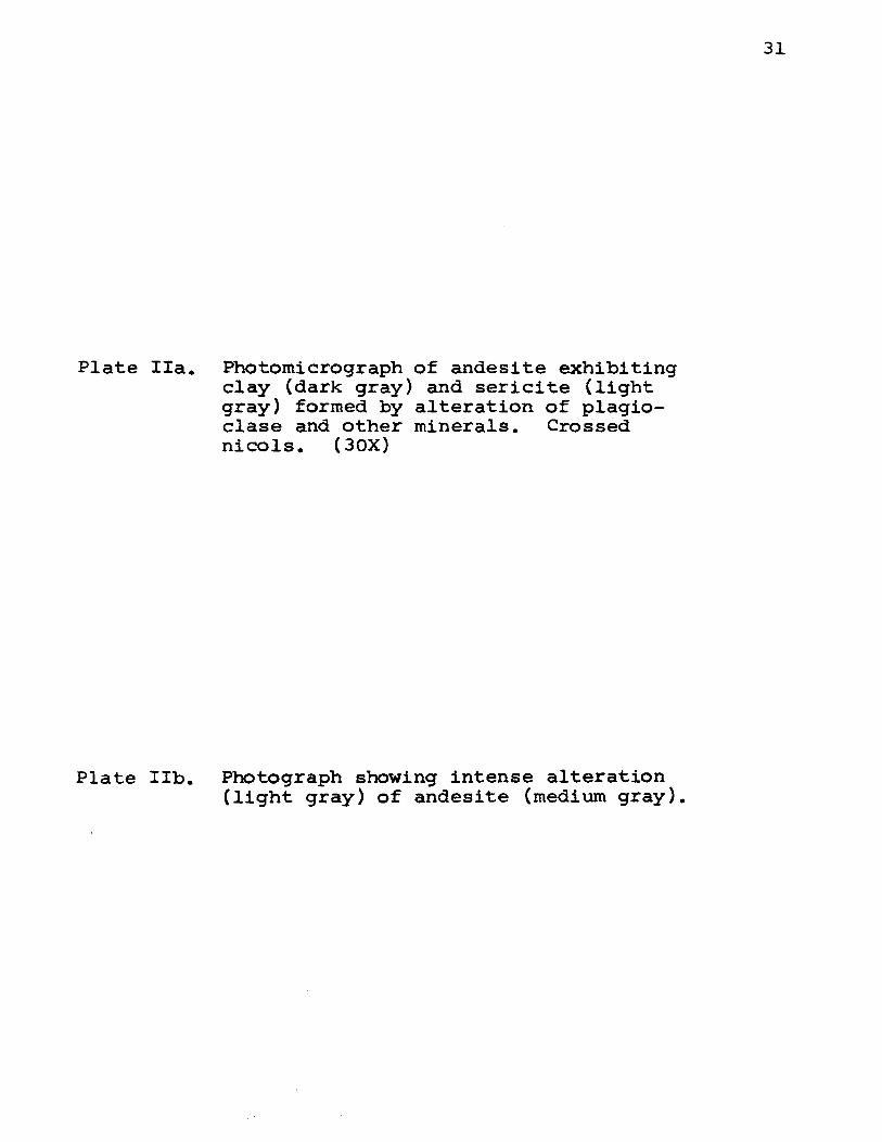
Plate IIa. Photomicrograph of andesite exhibiting clay (dark gray) and sericite (light gray) formed by alteration of plagioclase and other minerals. Crossed nicols. (30X)
Plate IIb. Photograph showing intense alteration (light gray) of andesite (medium gray).
31

32
Pl ate I!a
Plate !Ib

Plate Ilia. Photograph showing abundant fractures in andesite which have been filled by secondary quartz.
Plate IIIb. Photograph of intensely fractured andesite. Dark areas are caused by secondary iron oxide.
33

34
Plate I IIa
Plate IIIb ...

Plate IV~, Photograph showing contact of quartz porphyry (left) intrusive into andesite (right). Alteration and mineralization are prevalent along the contact.
35

36
Plate IV·

37
texture. Thirty-five per cent of the mapped surface is
quartz porphyry. The texture of the rock is porphyritic
and phenocrysts of quartz, plagioclase, hornblende, and
muscovite can be seen with the naked eye. Microscopic
examination reveals a holocrystalline groundmass consisting
of quartz plagioclase, and secondary sericite, clay, and
chlorite.
The clear and unaltered disseminated quartz phenocrysts
are subhedral to nearly euhedral. Some are as large as five
millimeters, but the average is close to two millimeters.
About one-half of the phenocrysts show embayment by matrix
material which crosses as much as one-third the width of
some phenocrysts. Quartz porphyry from drill holes suggests
that the size and abundance of the quartz phenocrysts in
creases with depth. Quartz phenocrysts comprise fifteen
per cent of the rock.
Plagioclase phenocrysts are scattered, subhedral to
nearly euhedral, average about three millimeters, but some
are as large as seventeen millimeters~ their size increases
with depth. Many phenocrysts are zoned and some zones ex
hibit greater alteration than others. Other phenocrysts
exhibit polysynthetic twinning and some carlsbad twinning.
The plagioclase phenocrysts are completely altered to secon
dary minerals in all of surface quartz porphyry specimens
collected by the writer.
Irregular to rounded phenocrysts of hornblende have an
average grain size of 0.2 millimeter. These disseminated

phenocrysts show alteration rims of chlorite. Hornblende
phenocrysts are rare.
38
Lath-like crystals of muscovite may be as large as 0.3
millimeter, but more commonly they are eighty microns. Mus
covite is scattered throughout the rock and exhibits altera
tion to clay. Muscovite is also rare.
The groundrnass constituents of the quartz porphyry
originally were quartz, orthoclase, and plagioclase. They
are subhedral to nearly euhedral and about forty microns is
size. Surface samples have a matrix grainsize of less than
ten microns (see Plate Va) while quartz porphyry matrix in
the deepest drilling is about twenty microns (see Plate Vb).
Among the secondary minerals in quartz porphyry, seri
cite and clay are the most abundant. Sericite has an
average grain size of less than two microns, but some are
as large as ten microns. The clusters of sericite are
scattered throughout the rock, but they are most abundant
in the former sights of plagioclase and orthoclase pheno
crysts. Clay material has an average size of about one
micron and it too is concentrated in areas of former pheno
crysts. Sericite and clay together comprise about sixty
per cent of the average quartz porphyry.
Surface samples of the rock exhibit holes where the
feldspar crystals have weathered out.
5. Tburmaline-~earing Breccia
Tburmaline-bearing breccia intrudes the quartz porphyry
and andesite, and it comprises less than five per cent of

Plate Va. Photomicrograph of quartz porphyry showing two subhedral quartz phenocrysts (black, top} and a plagioclase phenocryst ghost (top} now altered to sericite and clay. The phenocrysts are set in a fine-grained groundmass. Note the embayment of one quartz phenocryst. Also compare the size of the groundmass of this Plate and Plate Vb. Crossed nicols. (30X)
Plate Vb. Photomicrograph of quartz porphyry obtained in a diamond drill hole. Note the larger grain size of the quartz and orthoclase in the groundmass of this specimen as contrasted to that of quartz porphyry above which was collected on the surface. Crossed nicols. (30X}
39

40
Pla t e Va
Plate Vb

41
the mapped area. Three pipes were mapped in the "Old Work-
ings Area." Their diameters, from largest to smallest, at
the surface are: forty-five meters, thirty-meters, and ten
meters respectively. One pipe cuts quartz porphyry at the
surface, while the other two penetrate andesite. Since the
quartz porphyry is known to dip beneath the andesite, quartz
porphyry probably is intruded at depth by all three tourma
line-bearing breccia pipes. The fragments are mostly quartz
porphyry, but some are andesite. They are angular to sub
angular (see Plate VIa) and may be as large as three meters,
but usually they are several centimeters in size. These
light colored fragments are cemented by a dark aphanitic
matrix.
The matrix can be seen with the microscope to consist
of twenty per cent quartz and eighty per cent tourmaline.
The quartz is subhedral to nearly euhedral and about two
microns in grain size. The quartz is penetrated by long
thin tourmaline prisms, ten to fifteen microns long and one
to two microns wide. The tourmaline crystals were deposited
upon the breccia fragments and they grew outward in radial
groups into open spaces, where they form comb-like structures,
as shown in Plate VIb. Large quartz grains were deposited
at the same time or later than the tourmaline.
B. Ores
In the "Old Workings Area 11 primary sulphide minerals
are pyrite, chalcopyrite, and molybdenite. The secondary

Plate VIa. Photograph of tourmaline-bearing breccia showing quartz porphyry and andesite breccia fragments (light gray) cemented by a quartz-tourmaline matrix (dark gray).
Plate VIb. Photomicrograph showing (medium gray, long) and gray) cementing breccia gray). Crossed nicols.
tourmaline crystals quartz grains (light fragments (dark
(30X)
42

43
Plate VIa
Plate VIb

44
sulphide minerals are chalcocite and covellite 1 bro
chanthite and antlerite are present as ~econdary copper
sulphates and chrysocolla is present as a secondary copper
silicate. Copper Pitch found in the area consists of haus
mannite and braunite.
1. Primary Sulphide Minerals
Of the primary sulphide minerals, pyrite occurs in
quartz porphyry, rhyolite pebble conglomerate, and tourma
line-bearing breccia, while chalcopyrite is present in the
rhyolite pebble conglomerate and quartz porphyry and molyb
denite appears to be restricted to the quartz porphyry.
a. Pyrite
Cubic and rounded to irregular grains of pyrite occur
in veins and as disseminations throughout the three rock
types indicated above (see Plate VIIa). The grains are 0.2
millimeter in the conglomerate. Pyrite in:the quartz por
phyry is locally surrounded by iron staining. Pyrite com
prises as much as ten per cent of some quartz porphyry and
conglomerate specimens and fifteen per cent of some tourma
line-bearing breccia specimens.
b. Chalcopyrite
Chalcopyrite occurs in the conglomerate, where it fills
cracks in pyrite veins. Disseminated irregular grains of
chalcopyrite occur in quartz porphyry and conglomerate (see
Plate VIIb). As much as one per cent chalcopyrite was ob
served in some polished surfaces of· quartz porphyry while
as much as three per cent chalcopyrite is present in some

Plate VIIa. Photomicrograph of quartz porphyry showing abundant pyrite and one grain chalcocite. Reflected light. (30X)
Plate VIIb. Photomicrograph of rhyolite pebble conglomerate showing that chalcopyrite formed after pyrite. Reflected light. (30X)
45

46
Plate VUa
Plate VIIb
47
specimens of conglomerate. The disseminated grains are
about 0.1 millimeter in the conglomerate and forty microns
in the quartz porphyry. Chalcopyrite exhibits ice cake
texture with some pyrite (see Plate VIIIa) in veins after
pyrite grains indicating that it formed later than the
pyrite which it has replaced.
c. Molybdenite
Tabular crystals of molybdenite are sparcely scattered
in the quartz porphyry and in conglomerate where they have
an average size of forty microns. They are characterized
by their tabular shape and very strong anisotropism. One
crystal adjacent to pyrite suggests that molybdenite formed
first. MOlybdenite comprises less than one per cent of
roth rock units.
2. Secondary Sulphide Minerals
Secondary sulphide minerals formed in the "Old Workings
Area" are chalcocite and covellite. Where covellite. Where
cove.ilite is formed, it is intimately intergrown with chal
cocite.
a. Chalcocite
Irregularly shaped chalcocite is disseminated in the
conglomerate and tourmaline-bearing breccia. In the quartz
porphyry, chalcocite is associated with pyrite and covel
lite. That chalcocite has replaced pyrite is shown by the
occassional ice cake texture.
b. Covellite
Covellite occurs only in quartz porphyry, where it is

48
associated with chalcocite as intimate intergrowths, which
may have formed by unmixing from solid solution or perhaps
by replacement. The irregular grains have a size less than
one micron. These grains are always intergrown with chal
cocite. Oovellite comprises less than one tenth of a per
cent of quartz porphyry specimens examined by the writer.
3. Secondary Sulphate and Silicate Copper Minerals
The secondary sulphate minerals, brochanthite and
antlerite, and secondary copper silicate, chrysocolla,
occur in quartz porphyry in the "Old Workings Area." Mega
scopic identifications of these minerals were checked in
selected oil immersions under the polarizing microscope.
Brochanthite occurs as emerald green, loosely coherent
aggregates of acicular crystals in groups, drusy crusts,
and granular disseminations. These transparent to trans
lucent crystals have a vitreous luster. Brochanthite com
prises about forty per cent of the oxidized copper minerali-
zation.
Antlerite occurs as cross fiber veinlets and friable
interlaces aggregates of fibrous crystals. These crystals
are blackish green and exhibit a vitreous luster. Antlerite
has a slightly lower index and lower birefringence than does
brochanthite. Antlerite comprises about twenty per cent of
the surface copper minerals.
Earthy chrysocolla occurs as incrustations and veins.
Its bluish green color and earthy luster are diagnostic.
With the aid of the microscope chrysocolla can be seen to

49
have a low index of refraction and frequently colloform
texture. Chrysocolla comprises forty per cent of the oxi
dized copper minerals.
4. Miscellaneous
Irregular hematite grains are present in the quartz
porphyry in areas that are highly iron stained. The
average size of these grains is forty microns and they
occur as disseminations and veinlets.
Copper Pitch occurs south of the 110ld Workings Area 11
in a small vug al:out two meters in diameter and one-half
meter deep. It occurs as a dull earthy black manganese
oxide material on andesite.
The material, when studied under the microscope, ex
hibits abundant quartz veins crossing altered andesite.
The individual quartz grains which are about forty microns,
are surrounded by later manganese oxide. The clay and seri
cite of the altered andesite absorbed the manganese oxide
and iron oxide. It appears the andesite was altered, quartz
veining was introduced with manganese and copper minerali
zation and then the rock was oxidized.
The polished section study of the black opaque material
indicated the minerals hausmannite and braunite (see Plate
VIIIb). Hausmannite is gray with a slight brownish tint,
and some grains exhibit a reddish brown internal reflection.
It has strong anisotropism and it exhibits lamellar twinning.
Braunite displays a similar color and lower hardness to that
of hausmannite, but its anisotropism is weaker than that of

50
hausmannite. The mineral is granular and does not exhibit
internal reflection.

Plate VIIIa. Photomicrograph of ice cake texture between pyrite and chalcopyrite, in~ dicating that chalcopyrite has replaced pyrite. Reflected light. (30X)
Plate VIIIb. Photomicrograph of copper pitch showing hausmannite surrounded by braunite. Reflected light. (30X)
51

52
Plate VIIIa
Plate VIIIb

53
V. SUMMARY AND CONCLUSIONS
Five rock types were mapped in the "Old Workings Area".
These rock types, from oldest to youngest are rhyolite
pebble conglomerate, rhyolite porphyry, andesite, quartz
porphyry, and tourmaline-bearing breccia. In terms of
abundance, the mapped area comprises fifty-five per cent
andesite, thirty-five per cent quartz porphyry, and ten
per cent rhyolite pebble conglomerate, rhyolite porphyry,
and tourmaline-bearing breccia.
The quartz porphyry intruded the andesite as an chono
lith while tourmaline-bearing breccia intruded in the form
of a pipe. Three tou~maline-bearing breccia pipes occur in
the mapped area. The rhyolite pebble conglomerate appears
to be horizontal and has a thickness of more than ten feet.
The horizontal rhyolite porphyry is about twenty feet in
thickness, while the flat-lying andesite is approximately
fifty feet thick.
By petrographic examination the mineralogy and texture
was determined for each of the five rock types. The rhyo
lite pebble conglomerate to be composed of rhyolite pebbles
in a cementing matrix of the same composition. The rhyolite
porphyry flows, as well as the rhyolite pebble conglomerate,
consist of orthoclase, plagioclase, quartz, and hornblende
phenocrysts in a fine-grained groundmass of quartz and ortho
clase. The andesite flow, originally consisted of andesine
plagioclase, hornblende, and very minor quartz. The least

54
altered quartz porphyry consists of phenocrysts of quartz,
andesine plagioclase, and hornblende in a fine-grained
groundmass of quartz, orthoclase, and plagioclase. The
tourmaline-bearing breccia consists of fragments of quartz
porphyry and andesite in a matrix of quartz and tourmaline.
The rocks in the "Old Workings Area 11 are intensely
altered by hydrothermal solutions. This is attested to by
the presence of secondary alteration products and intro
duced secondary minerals: quartz, sericite, chlorite, epi
dote, and sulphides. Biotite, which normally is the first
mineral to be attacked, is altered to muscovite. The feld
spars are intensely altered to sericite and clay minerals,
while hornblende is completely altered to chlorite. Second
ary quartz veinlets are abundant in the altered rocks. The
most intense alteration surrounds the quartz porphyry intru
sives and it decreases in intensity outward.
The primary sulphides were found to occur in three of
the five mapped rock units: quartz porphyry, tourmaline
bearing breccia, and rhyoli~e pebble conglomerate. With
the aid of the ore microscope, pyrite was found to be most
abundant in the tourmaline-bearing breccia, but also to
occur in quartz porphyry and rhyolite pebble conglomerate.
Other sulphides found to occur in these three rock types,
in order of abundance, are: chalcopyrite, chalcocite, molyb
denite, and covellite.
The action of weathering is attested to by the prevently
iron oxide staining of the rocks in the mapped area.

Weathering has probably contributed to the alteration of
the surface specimens collected by the writer, for they
are more altered than drill core from depth. How much
alteration is due to hydrothermal solutions and how much
is due to weathering has been difficult to determine in
the present study.
55
Surface oxidation has formed an oxidized layer in
which brochanthite, antlerite, and chrysocolla are present.
These secondary minerals are most abundant on the surface
in the "Old Workings Area".

56
VI. BIBLIOGRAPHY
A. References Cited
Creasey, J. c. (1959), Hydrothermal Alteration, Econ. Geol., vol. 54, no. 3, pp. 351-373.
Cristi, J. M. (1959), Chile, Geol. Soc. Amer. Mem. 65, pp. 189-214.
Emmons, R. c. (1959), The Universal Stage, Geol. Soc. Amer. Memoir 8, pp. 115-133.
Gustafson, (1964), Personal Communications.
Harrington, H. J. (1961), Geology of Antofagasta and Atacama Provinces, l~rthern Chile, Amer. Assoc. Petrol. Geol. Bull., vol. 45, no. 2, pp. 169-197.
Kents, P. (1961), Origin of Porphyry Breccias, Econ. Geol., vol. 56, no. 8, pp. 1465-1469.
Kents, P. (1964), Special Breccias Associated with Hydrothermal Developments in the Andes, Econ. Geol., vol. 59, no. 8, pp. 1551-1563.
Swayne, Trask (1960), El Salvador Development, Mining Engineering, April, pp. 6-10.
B. Other References
Anderson, c. A. (1950), Alteration and Metallization in the Bagdad POrphyry Copper Deposit, Arizona, Eoon. Geol., vol. 45, pp. 609-628.
Burnham, c. W. (1962), Facies and Types of Hydrothermal Alteration, Econ. Geol., vol. 57, pp. 768-784.
Gilluly, J. (1946), The Ajo ~ning District, Arizona, u.s. Geol. Surv. Prof. Paper 209.
Kerr, P. F. (1951), Alteration Features at Silver Bell, Arizona, Geol. Soc. Amer. Bull., vol. 62, pp. 451-480.
Kerr, P. F. and others (.1950), Hydrothermal Alteration at Santa Rita, New Mexico, Geol. Soc. Amer. Bull., vol. 61, pp. 275-347.
Leroy, P. G. (1954), Correlation of Copper Mineralization with Hydrothermal Alteration in Santa Rita Porphyry Copper Deposits, New Mexico, Geol. Soc. Amer. Bull., vol. 65, pp. 739-768.

57
Lopez, v. M. (1939), The Primary Mineralization at Chuquicamata, Chile, South America, Econ. Geol., vol. 36, pp. 674-711.
McCartney, w. D. (1962), Mineralization in Mobile Belts, Econ. Geol., vol. 57, no. 7, pp. 1131-1132.
Perry, Vincent D. (1961), The Significance of Mineralized Breccia Pipes, Mining Engineering, April and Am. Inst. Mining, Met. and Pet. Eng. Trans., vol. 220, pp. 216-226.
Peterson, N. P.~ Gilbert, c. M.~ Quick, G. L. (1946), Hydrothermal Alteration in the Castle Dome Copper Deposit, Arizona, Econ. Geol., vol. 41, pp. 820-840.
Schwartz, G. M. (1947), Hydrothermal Alteration in the Porphyry Copper Deposits, Econ. Geol., vol. 42, pp. 319-352.
Stringham, B. (1958), Relationship of Ore to Porphyry in the Basin and Range Province, u.s.A., Econ. Geol., vol. 53, pp. 806-821.
Stringham, B. (1953), Granitization and Hydrothermal Alteration at Bingham, Utah, Geol. Soc. Amer. Bull., vol. 64, pp. 945-992.
Stringham, B. (1960), Porphyry Copper, Econ. Geol., vol. 55, no. 8, pp. 1622-1630.

VITA
Bertis James Vander Schaaff III was born February 8,
1941, in Rochester, New York, the son of Mr. and Mrs.
Bertis J. Vander Schaaff.
He graduated from Irondequoit High School in Roches
ter, New York, in 1959. Upon graduation from high school
he enrolled at St. Lawrence University where he received
a Bachelor of Science Degree in Geology in June, 1963.
Throughout his four years at St. Lawrence University he
prepared mineral and rock collections for colleges and
universities at Ward's Natural Science Establishment.
In September, 1963, he enrolled in the University of
Missouri at Rolla, for work toward his Master's Degree in
Geology.
115~60
58


