
1,000
2,000
3,000
4,000
Elev
atio
n (
feet
)
Miles0 10 20 30 40 50 60 70 0 010 1020 2030 40
Elevation Profiles
Section 1 Section 2 Section 3
19
19
207
207
19
19
218
Hwy
26
26
Day
Hw
y
JohnDay
John Day Fossil BedsNational Monument:
Painted Hills Unit(no camping)
John Day Fossil BedsNational Monument:Clarno Unit(no camping)
John Day Fossil BedsNational Monument:
Sheep Rock Unit(no camping)
Spray
Antone
KinzuaFossil
Mitchell
Winlock
Waterman
Richmond
Kimberly
LonerockMayville
Service Creek
Twickenham
Joh
n D
ay H
wy
Ochoco Highway
Row
eCr
eek
Rd
GirdsC
reek Rd
John
OLD
WE
ST
SC
EN
ICBI
KEWAY
BIK
EW
AY
O C H O C O M O U N T A I N S
Butte Creek
Thirtymile
Cree
kRiver
John DayRiver
DayJohn
Roug
h Gra
vel Road
Bear HollowCounty Park
MuleshoeCampground
Spray RiverFront Park(City) Shady Grove
Day use area(BLM)
Lone PineCampground(BLM)
Julia HendersonPioneer Park
Shelton WaysidePark
Big Sarvice CorralCampground
Thomas CondonPaleontology Center
Service CreekCampground(BLM) overnight
parkingavailable
Keyes CreekSummit4,382 ft.
X
Painted HillsScenic Bikeway
State Parks and Rec. Info (800) 551-6949
www.RideOregonRide.com/PaintedHills
State Park Reservations(800) 452-5687 N
Mileage fromstart of route section
Food
Restrooms
Drinking water
Day useparking
25
Lodging
CampgroundFullservices
Conveniencestore
Bikewaysections
Old West Bikeway
X
0 10 miles5
5 10 15 km
80
12
16
4
20
24
4
8 1216
2028
30
34
28
32
36
40
44
48
4
8
12
56
52
60
64
X XX X
X
XX
X
X X
X
X
X
XX
X
X
X
X
X
X
X
X
X
X
X
X
X
X
XX
X
X
X
X
X
X
X
X
X
XXX X
X XX X
XX
XX
X
X
X
X
XXSUTTON
WARM
SPRINGS
TRIBAL
LAND
WILDERNESS
STUDY
AREA
MOUNTAIN

Painted Hills Scenic Bikeway February 11, 2016
Painted Hills Scenic Bikeway
Clarno to Painted Hills Segment (purple)
Mile- point
Directions Notes/Points of Interest
0.0 East on OR-218 from John Day Fossil Beds National Monument, Clarno Unit
Scenic Bikeway route segment starts at the entrance to the trailhead and picnic area for the John Day Fossil Beds, Clarno Unit. Restrooms and water are available in the picnic area.
10.8 Continue on OR-218 Summit - 3,722 feet 16.1 Right on OR-19 Fossil - store, restaurant, lodging, camping 22.7 Continue on OR-19 Bear Hollow County Park - restrooms, water,
camping 25.2 Continue on OR-19 Butte Creek Summit - 3,790 feet 26.1 Right on Rowe Creek Rd 27.4 Continue on Rowe Creek Rd Summit - 3,790 feet 38.0 Continue on Twickenham Rd Road name changes 41.1 Continue across John Day River Twickenham - restrooms 41.2 Bear left on Twickenham
Rd/Girds Creek Rd
48.5 Right on OR-207 52.0 Continue on OR-207 Summit - 3,594 feet 58.3 Right on US-26 Mitchell 0.4 mile east - store, restaurant, water,
lodging, camping 61.6 Right on Burnt Ranch Rd 67.2 Left on Bear Creek Rd Gravel road 67.6 Left to picnic area 67.8 Scenic Bikeway segment ends at
picnic area John Day Fossil Beds National Monument, Painted Hills Unit - restrooms, water, no camping
Rowe Creek Road to Kimberly Segment (green)
Mile- point
Directions Notes/Points of Interest
0.0 Southeast on OR-19 from intersection with Rowe Creek Rd
Scenic Bikeway route segment starts at intersection

Painted Hills Scenic Bikeway February 11, 2016
Mile- point
Directions Notes/Points of Interest
0.5 Continue on OR-19 Sheldon Wayside County Park - restrooms, camping
1.3 Continue on OR-19 Julia Henderson Pioneer Park - restrooms, water, no camping
9.3 Continue on OR-19 Service Creek - store, restaurant, lodging 9.5 Continue on OR-19/OR-207 Service Creek Campground (BLM) 0.3 mile right
on OR-207 – restrooms, no water 11.5 Continue on OR-19/OR-207 Muleshoe Campground (BLM) - restrooms, no
water 21.9 Continue on OR-19/OR-207 Spray - store, restaurant, lodging, camping 22.1 Bear left on OR-19/OR-207 Spray River Front Park 0.3 mile to the right on
Parrish Creek Rd - restrooms, water, camping 24.9 Continue on OR-19 28.5 Continue on OR-19 Shady Grove Day Use Area - restrooms, no water 34.6 Scenic Bikeway segment ends at
intersection with Old West Scenic Bikeway in Kimberly
Girds Creek Road to OR-19 at Service Creek Segment (orange)
Mile- point
Directions Notes/Points of Interest
0.0 Northeast on OR-207 from intersection with Girds Creek Rd
Scenic Bikeway segment starts at intersection
1.9 Continue on OR-207 Mabe Hill Summit - 3,561 feet 8.7 Continue on OR-207 Waldron Summit - 3,165 feet
13.8 Continue on OR-217 Service Creek Campground (BLM) - restrooms, no water
14.1 Scenic Bikeway segment ends at intersection with OR-19
Full Route
Mile- point
Directions Notes/Points of Interest
0.0 East on OR-218 from John Day Fossil Beds National Monument, Clarno Unit
Scenic Bikeway route starts at the entrance to the trailhead and picnic area for the John Day Fossil Beds, Clarno Unit. Restrooms and water are available in the picnic area.
10.8 Continue on OR-218 Summit - 3,722 feet 16.1 Right on OR-19 Fossil - store, restaurant, lodging, camping 22.7 Continue on OR-19 Bear Hollow County Park - restrooms, water,
camping 25.2 Continue on OR-19 Butte Creek Summit - 3,790 feet
Painted Hills Scenic Bikeway February 11, 2016
Mile- point
Directions Notes/Points of Interest
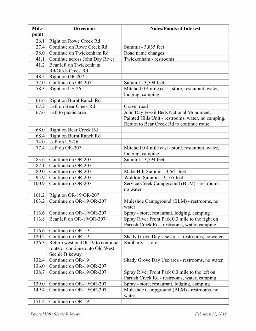
26.1 Right on Rowe Creek Rd 27.4 Continue on Rowe Creek Rd Summit - 3,835 feet 38.0 Continue on Twickenham Rd Road name changes 41.1 Continue across John Day River Twickenham - restrooms 41.2 Bear left on Twickenham
Rd/Girds Creek Rd
48.5 Right on OR-207 52.0 Continue on OR-207 Summit - 3,594 feet 58.3 Right on US-26 Mitchell 0.4 mile east - store, restaurant, water,
lodging, camping 61.6 Right on Burnt Ranch Rd 67.2 Left on Bear Creek Rd Gravel road 67.6 Left to picnic area John Day Fossil Beds National Monument,
Painted Hills Unit - restrooms, water, no camping. Return to Bear Creek Rd to continue route
68.0 Right on Bear Creek Rd 68.4 Right on Burnt Ranch Rd 74.0 Left on US-26 77.4 Left on OR-207 Mitchell 0.4 mile east - store, restaurant, water,
lodging, camping 83.6 Continue on OR-207 Summit - 3,594 feet 87.1 Continue on OR-207 89.0 Continue on OR-207 Mabe Hill Summit - 3,561 feet 95.9 Continue on OR-207 Waldron Summit - 3,165 feet
100.9 Continue on OR-207 Service Creek Campground (BLM) - restrooms, no water
101.2 Right on OR-19/OR-207 103.2 Continue on OR-19/OR-207 Muleshoe Campground (BLM) - restrooms, no
water 113.6 Continue on OR-19/OR-207 Spray - store, restaurant, lodging, camping 113.8 Bear left on OR-19/OR-207 Spray River Front Park 0.3 mile to the right on
Parrish Creek Rd - restrooms, water, camping 116.6 Continue on OR-19 120.2 Continue on OR-19 Shady Grove Day Use area - restrooms, no water 126.3 Return west on OR-19 to continue
route or continue onto Old West Scenic Bikeway
Kimberly - store
132.4 Continue on OR-19 Shady Grove Day Use area - restrooms, no water 136.0 Continue on OR-19/OR-207 138.7 Continue on OR-19/OR-207 Spray River Front Park 0.3 mile to the left on
Parrish Creek Rd - restrooms, water, camping 139.0 Continue on OR-19/OR-207 Spray - store, restaurant, lodging, camping 149.4 Continue on OR-19/OR-207 Muleshoe Campground (BLM) - restrooms, no
water 151.4 Continue on OR-19

Painted Hills Scenic Bikeway February 11, 2016
Mile- point
Directions Notes/Points of Interest
151.7 Continue on OR-19 Service Creek - store, restaurant, lodging 159.6 Continue on OR-19 Julia Henderson Pioneer Park - restrooms, water,
no camping 160.4 Continue on OR-19 Sheldon Wayside County Park - restrooms,
camping 160.9 Scenic Bikeway full route ends at
intersection with Rowe Creek Rd


