
1
OSCAR:OnlineServicesforCorrectionofAtmosphereinRadar
PaulvonAllmen,EricFielding,EricFishbein,ZhangfanXing,LeiPan,MartinLoJetPropulsionLaboratory,CaliforniaInstituteofTechnology,Pasadena,CA91109
ZhenhongLiSchoolofGeographicalandEarthSciences,UniversityofGlasgow,Glasgow,U.K.
1. IntroductionInterferometricSyntheticApertureRadar(InSAR)isusedtomeasurethedeformationofEarth’ssurfacebycomputingtheinterferenceoftworadarimagestakenatdifferenttimes.ThephaseofaSARimageisaffectedbypropagationdelaysintheatmosphereandconstitutesthelargestsourceoferrorinInSARmeasurements.Whileboththeionosphereandthetropospherecontributetothepropagationdelays,themajorityofSARarchivesisintheC‐band(wavelength6cm)andisonlyweaklyaffectedbytheionosphere.OSCARconcentratesonwebservicesforlocating,collectingandprocessingatmosphericdatatocorrecttheInSARpropagationdelayscausedbythewetatmosphere.InSAR‐basedcorrectionshavehistoricallyusedsingleatmosphericdatasetsandadhocmethodologiesthatcannotbeappliedtoallsituations.Onecandistinguishfourmethodstocorrectforatmosphericdelays,whichareusingancillarydata:a. ContinuousGlobalPositioningSystems:Global
NavigationSatelliteSystemssignalshavepropagationdelayssimilartothoseofInSAR.Thegroundreceiverscanmeasurebothionosphericandtroposphericdelays.TheionosphericdelayisestimatedfromthemultiplefrequenciesoftheGPSsignalbyusingthepropertythatdelaysaredispersiveintheionospherebutnotinthetroposphere.TheremainingdelayoftheGPSsignalisthetroposphericcomponent.ThetotaltroposphericdelaycanbeestimatedasrandomwalkprocessesandthenbeinterpolatedspatiallyandtemporallytothegridoftheInSARimages.
b. NearIRabsorptionandreflectiondata:TheMODISinstrument(onboththeNASATerraandAquasatellites)providesawatervaporproductthatcanbecalibratedtoagreewithGPSdatabyusingonecontinuousGPSstationwithina2,030kmx1,354kmMODISscene.TheMERISinstrumentiscollocatedwiththeradarASARontheEuropeanplatformENVISAT.ItproducesawatervaporproductthatcloselyagreeswithGPSdata.BothMODISnearIRandMERISnearIRmeasuretheabsorptionofreflectedsunlightbywatervaporinthetroposphere.Thismeansthattheycanonlymakemeasurementsduringtheday.Inaddition,
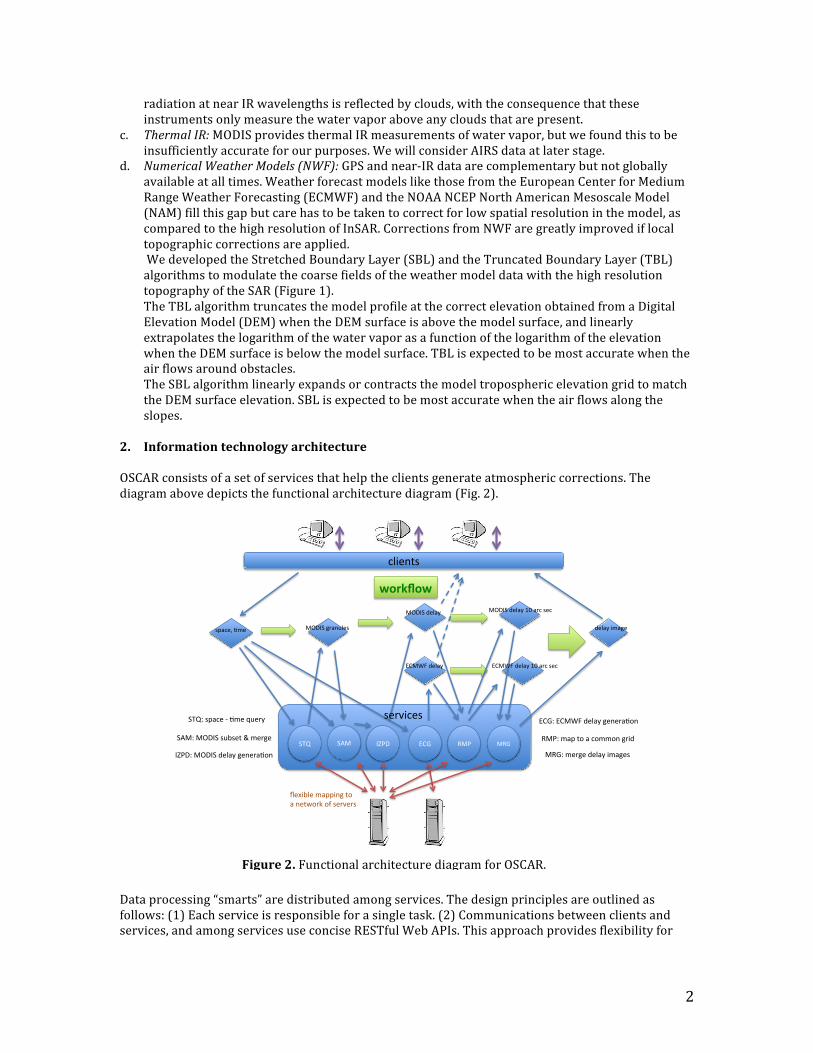
Figure1.StretchedBoundaryLayerandTruncatedBoundaryLayeralgorithmsfortheextrapolationofthespecifichumidityasafunctionofaltitude.Thetoppanelillustratesthetroposphericmodelandtheairflowpatternsnearobstacles.ThemiddlepanelshowstheoriginalECMWFmodel(green),theTBL(blue)andSBL(red)precipitablewatervaporprofiles.Thelowerpanelshowstheelevationoftheunperturbedprofile.
2
radiationatnearIRwavelengthsisreflectedbyclouds,withtheconsequencethattheseinstrumentsonlymeasurethewatervaporaboveanycloudsthatarepresent.
c. ThermalIR:MODISprovidesthermalIRmeasurementsofwatervapor,butwefoundthistobeinsufficientlyaccurateforourpurposes.WewillconsiderAIRSdataatlaterstage.
d. NumericalWeatherModels(NWF):GPSandnear‐IRdataarecomplementarybutnotgloballyavailableatalltimes.WeatherforecastmodelslikethosefromtheEuropeanCenterforMediumRangeWeatherForecasting(ECMWF)andtheNOAANCEPNorthAmericanMesoscaleModel(NAM)fillthisgapbutcarehastobetakentocorrectforlowspatialresolutioninthemodel,ascomparedtothehighresolutionofInSAR.CorrectionsfromNWFaregreatlyimprovediflocaltopographiccorrectionsareapplied.WedevelopedtheStretchedBoundaryLayer(SBL)andtheTruncatedBoundaryLayer(TBL)algorithmstomodulatethecoarsefieldsoftheweathermodeldatawiththehighresolutiontopographyoftheSAR(Figure1).TheTBLalgorithmtruncatesthemodelprofileatthecorrectelevationobtainedfromaDigitalElevationModel(DEM)whentheDEMsurfaceisabovethemodelsurface,andlinearlyextrapolatesthelogarithmofthewatervaporasafunctionofthelogarithmoftheelevationwhentheDEMsurfaceisbelowthemodelsurface.TBLisexpectedtobemostaccuratewhentheairflowsaroundobstacles.TheSBLalgorithmlinearlyexpandsorcontractsthemodeltroposphericelevationgridtomatchtheDEMsurfaceelevation.SBLisexpectedtobemostaccuratewhentheairflowsalongtheslopes.
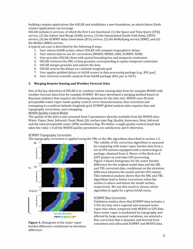
2. Informationtechnologyarchitecture OSCARconsistsofasetofservicesthathelptheclientsgenerateatmosphericcorrections.Thediagramabovedepictsthefunctionalarchitecturediagram(Fig.2).
Dataprocessing“smarts”aredistributedamongservices.Thedesignprinciplesareoutlinedasfollows:(1)Eachserviceisresponsibleforasingletask.(2)Communicationsbetweenclientsandservices,andamongservicesuseconciseRESTfulWebAPIs.Thisapproachprovidesflexibilityfor
!"#$%&'(
!"#$%"!&
)*+( ),-( ./01( 234( -54(
2346(23-78(9$":;(<$%$=:>?%(
5-0(
@$A#B"$(C:DD#%<(&?(
:(%$&E?=F(?G('$=H$='(
)*+6('D:!$(I(>C$(JK$=;(
),-6(-L1.)('KB'$&(M(C$=<$(
./016(-L1.)(9$":;(<$%$=:>?%(
5-06(C:D(&?(:(!?CC?%(<=#9(
-546(C$=<$(9$":;(#C:<$'((
'D:!$N(>C$( -L1.)(<=:%K"$'( 9$":;(#C:<$(
'$=H#!$'(
-L1.)(9$":;(
23-78(9$":;(
-L1.)(9$":;(OP(:=!('$!(
23-78(9$":;(OP(:=!('$!(
Figure2.FunctionalarchitecturediagramforOSCAR.
3
buildingcomplexapplicationslikeOSCARandestablishesanewfoundation,onwhichfutureEarthscienceapplicationscanleverage.OSCARincludes6services,ofwhichthefirst4arefunctional:(1)theSpaceandTimeQuery(STQ)service,(2)theSubsetAndMerge(SAM)service,(3)theInterpolatedZenithPathDelay(IZPD)service,(4)theECMWFdelayGeneration(ECG)service,(5)theReMaPpingservice(RMP),and(6)theMeRGe(MRG)service.Atypicalusecaseisdescribedbythefollowing8steps.
1. UserselectsInSARscenes,whereOSCARwillcomputetroposphericdelays2. Userselectsdatatouseforcorrections(MODIS,MERIS,AIRS,ECMWF,NAM)3. UserprovidesOSCARclientwithspatialboundingboxandtemporalconstraints4. OSCARretrievestheURLofdatagranulescorrespondingtospatio‐temporalconstraints5. OSCARmergesgranulesandsubsetsthedata6. OSCARreturnsthedelaysonalatitude‐longitudegrid7. UserappliesgriddeddelaystoInSARscenesindataprocessingpackage(e.g.,ROI_pac)8. UserretrievesscientificanalysisfromInSARpackage(ROI_pacorISCE)
3. MergingRemoteSensingandWeatherForecastDataOneofthekeyobjectivesofOSCARistocombineremotesensingdatafromforexampleMODISwithweatherforecastdatafromforexampleECMWF.WehavedevelopedamergingmethodbasedonBayesianstatisticsthatrequiresthefollowingelementsforthedatasets.MODISnear‐IRtotalprecipitablewatervaporneedsqualitycontrol,errorcharacterization,biascorrectionandremappingtoauniformlatitude‐longitudegrid.ECMWFglobalanalysisdatarequiresbiasandtopographycorrections,andremapping.MODISQualityControlModelThequalityofthedataisalsoassessedfrom5parametersdirectlyavailablefromtheMODISdata:Water_Vapor_Near_Infrared,Cloud_Mask_QA,surfacetypeflag,Quality_Assurance_Near_Infrared,andthetotalprecipitablewater(NIR)usefulnessflag.Wedefineasinglequalitycontrolmaskthattakesthevalue1ifalltheMODISqualityparametersaresatisfactoryand0otherwise.ECMWFTopographyCorrectionThetopographycorrectionisappliedusingtheTBLortheSBLalgorithmsdescribedinsection1.2.
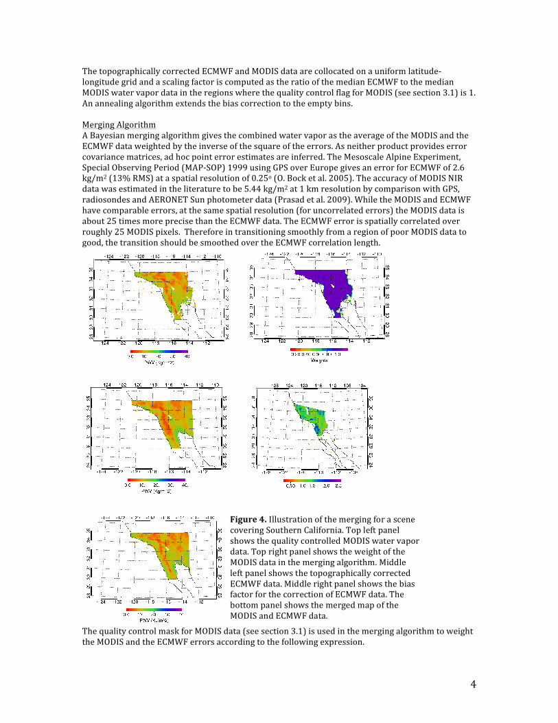
ThevalidityofthecorrectionalgorithmsisassessedbycomparingwithwatervaporburdendatafromasetofGPSstationsequippedwithameteorologicalpackage,obtainedfromA.MooreoftheBocketal.AISTprojectonreal‐timeGPSprocessing.Figure3showshistogramsforthewaterburdendifferencefortheoriginalmodeldataandtheSBLandTBLcorrecteddata,conditionalontheelevationdifferencebetweenthemodelandtheGPSstation.ThisstatisticalanalysisshowsthattheSBLandTBLalgorithmsleadtobettercorrectionswhenthesurfaceisaboveandbelowthemodelsurface,respectively.WeusethisresulttochoosewhichalgorithmtoapplyforagivenInSARscene.ECMWFBiasCorrectionValidationstudiesshowthatECMWFdataincludesa5.5%drybiasandaregionalandseasonalwatervaporbiaswhencomparedwithMODISorGPSdata.Sincewatervaporismodulatedbytopographyandaffectedbylargeseasonalvariations,weselectedabiascorrectionthatisdynamicandderivedfromcoincidentandcollocatedECMWFandMODISdata.Figure3.Histogramofthewatervapor
burdendifferenceconditionalonelevationdifference.
4
ThetopographicallycorrectedECMWFandMODISdataarecollocatedonauniformlatitude‐longitudegridandascalingfactoriscomputedastheratioofthemedianECMWFtothemedianMODISwatervapordataintheregionswherethequalitycontrolflagforMODIS(seesection3.1)is1.Anannealingalgorithmextendsthebiascorrectiontotheemptybins.MergingAlgorithmABayesianmergingalgorithmgivesthecombinedwatervaporastheaverageoftheMODISandtheECMWFdataweightedbytheinverseofthesquareoftheerrors.Asneitherproductprovideserrorcovariancematrices,adhocpointerrorestimatesareinferred.TheMesoscaleAlpineExperiment,SpecialObservingPeriod(MAP‐SOP)1999usingGPSoverEuropegivesanerrorforECMWFof2.6kg/m2(13%RMS)ataspatialresolutionof0.25o(O.Bocketal.2005).TheaccuracyofMODISNIRdatawasestimatedintheliteraturetobe5.44kg/m2at1kmresolutionbycomparisonwithGPS,radiosondesandAERONETSunphotometerdata(Prasadetal.2009).WhiletheMODISandECMWFhavecomparableerrors,atthesamespatialresolution(foruncorrelatederrors)theMODISdataisabout25timesmoreprecisethantheECMWFdata.TheECMWFerrorisspatiallycorrelatedoverroughly25MODISpixels.ThereforeintransitioningsmoothlyfromaregionofpoorMODISdatatogood,thetransitionshouldbesmoothedovertheECMWFcorrelationlength.
ThequalitycontrolmaskforMODISdata(seesection3.1)isusedinthemergingalgorithmtoweighttheMODISandtheECMWFerrorsaccordingtothefollowingexpression.
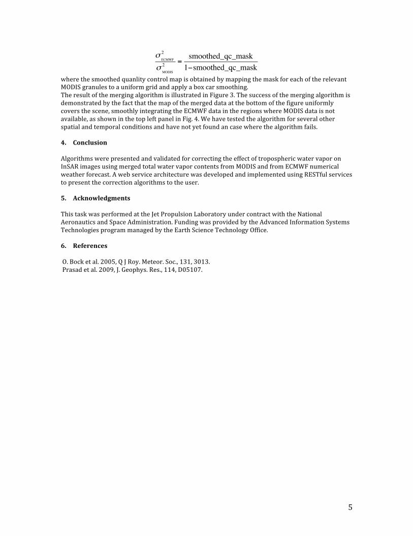
Figure4.IllustrationofthemergingforascenecoveringSouthernCalifornia.TopleftpanelshowsthequalitycontrolledMODISwatervapordata.ToprightpanelshowstheweightoftheMODISdatainthemergingalgorithm.MiddleleftpanelshowsthetopographicallycorrectedECMWFdata.MiddlerightpanelshowsthebiasfactorforthecorrectionofECMWFdata.ThebottompanelshowsthemergedmapoftheMODISandECMWFdata.
5
!ECMWF
2
!MODIS
2=smoothed_qc_mask
1!smoothed_qc_mask
wherethesmoothedquanlitycontrolmapisobtainedbymappingthemaskforeachoftherelevantMODISgranulestoauniformgridandapplyaboxcarsmoothing.TheresultofthemergingalgorithmisillustratedinFigure3.Thesuccessofthemergingalgorithmisdemonstratedbythefactthatthemapofthemergeddataatthebottomofthefigureuniformlycoversthescene,smoothlyintegratingtheECMWFdataintheregionswhereMODISdataisnotavailable,asshowninthetopleftpanelinFig.4.Wehavetestedthealgorithmforseveralotherspatialandtemporalconditionsandhavenotyetfoundancasewherethealgorithmfails.4. ConclusionAlgorithmswerepresentedandvalidatedforcorrectingtheeffectoftroposphericwatervaporonInSARimagesusingmergedtotalwatervaporcontentsfromMODISandfromECMWFnumericalweatherforecast.AwebservicearchitecturewasdevelopedandimplementedusingRESTfulservicestopresentthecorrectionalgorithmstotheuser.5. AcknowledgmentsThistaskwasperformedattheJetPropulsionLaboratoryundercontractwiththeNationalAeronauticsandSpaceAdministration.FundingwasprovidedbytheAdvancedInformationSystemsTechnologiesprogrammanagedbytheEarthScienceTechnologyOffice.6. ReferencesO.Bocketal.2005,QJRoy.Meteor.Soc.,131,3013.Prasadetal.2009,J.Geophys.Res.,114,D05107.


![IEEE SEM - Wavelengths · 2018. 12. 6. · April 1, 2015 [IEEE SEM - WAVELENGTHS] Wavelengths. Section Chair’s Message . I received several responses to last month’ Chair’s](https://cdn.vdocuments.us/doc/165x107/60023b09958d664df8767988/ieee-sem-wavelengths-2018-12-6-april-1-2015-ieee-sem-wavelengths-wavelengths.jpg)


