U.S. Department of the Interior U.S. Geological Survey
Leveraging Geodetic Data to Reduce Losses from Earthquakes
Open-File Report 2018–1037

U.S. Department of the Interior U.S. Geological Survey
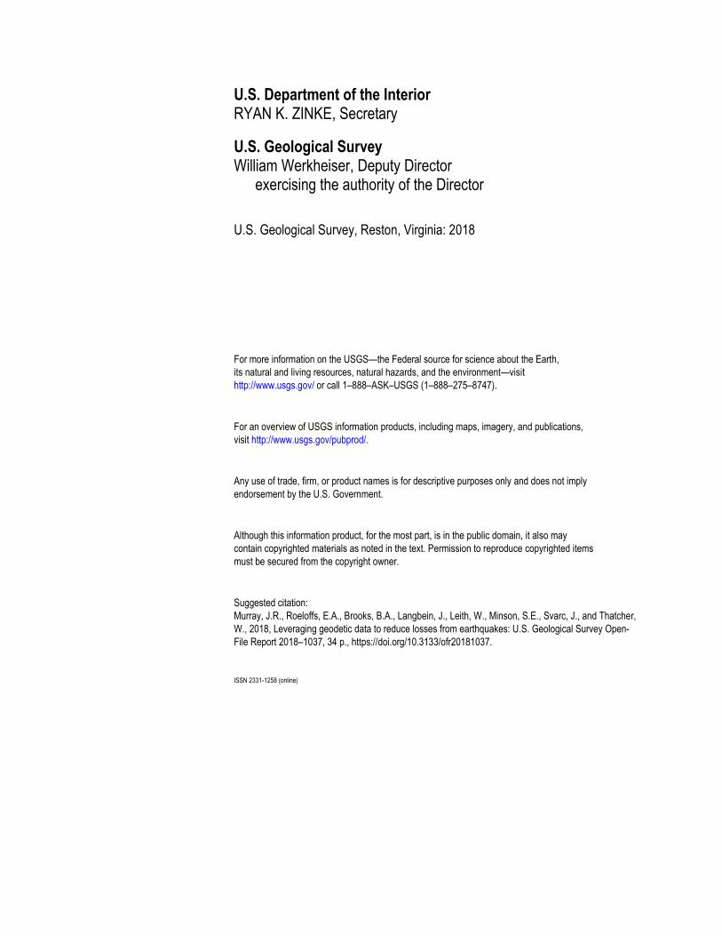
Cover image: Clockwise from upper left: James Lienkaemper (USGS) conducting alignment array field work (photograph by Forrest McFarland, San Francisco State University); Synthetic Aperture Radar Interferogram and fault model for the 2008 Mw6.0 Wells, Nevada earthquake (photograph by Charles Wicks, USGS; ALOS/PALSAR data are copyright JAXA and the Japanese Ministry of Economy, Trade and Industry (2007, 2008) and were provided by the Alaska Satellite Facility); continuous Global Positioning System station operated by USGS Earthquake Science Center (photograph by Andre Basset, UNAVCO Inc.); mobile laser scanning apparatus (photograph by Benjamin Brooks, USGS); temporary Global Positioning System deployment (photograph by James Sutton, USGS).

U.S. Department of the Interior U.S. Geological Survey
Leveraging Geodetic Data to Reduce Losses from Earthquakes
By Jessica R. Murray, Evelyn Roeloffs, Benjamin Brooks, John Langbein, William Leith, Sarah Minson, Jerry Svarc, and Wayne Thatcher
Open-File Report 2018–1037
U.S. Department of the Interior RYAN K. ZINKE, Secretary
U.S. Geological Survey William Werkheiser, Deputy Director exercising the authority of the Director
U.S. Geological Survey, Reston, Virginia: 2018
For more information on the USGS—the Federal source for science about the Earth,
its natural and living resources, natural hazards, and the environment—visit
http://www.usgs.gov/ or call 1–888–ASK–USGS (1–888–275–8747).
For an overview of USGS information products, including maps, imagery, and publications,
visit http://www.usgs.gov/pubprod/.
Any use of trade, firm, or product names is for descriptive purposes only and does not imply
endorsement by the U.S. Government.
Although this information product, for the most part, is in the public domain, it also may
contain copyrighted materials as noted in the text. Permission to reproduce copyrighted items
must be secured from the copyright owner.
Suggested citation:
Murray, J.R., Roeloffs, E.A., Brooks, B.A., Langbein, J., Leith, W., Minson, S.E., Svarc, J., and Thatcher,
W., 2018, Leveraging geodetic data to reduce losses from earthquakes: U.S. Geological Survey Open-
File Report 2018–1037, 34 p., https://doi.org/10.3133/ofr20181037.
ISSN 2331-1258 (online)
iii
Acknowledgments
This report incorporates valuable comments, suggestions, and information from the following individuals (in alphabetical order): Brad Aagaard, Andrew Barbour, Michael Blanpied, Robert Graves, Peter Haeussler, Ruth Harris, Stephen Hickman, Kenneth Hudnut, Frederick Pollitz, Charles Wicks, Cecily Wolfe, and Yuehua Zeng. In addition, versions were circulated to the U.S. Geological Survey Earthquake Hazards Program Council (October, 2016), the Scientific Earthquake Studies Advisory Committee (November, 2016), and the Advanced National Seismic System Advisory Committee (February, 2017), all of whom provided additional feedback that informed the final document.

iv
Contents
Acknowledgments ......................................................................................................................................... iii Abstract ......................................................................................................................................................... 1 Geodesy in the Context of NEHRP and NHMA Objectives ............................................................................ 4 How Geodesy Contributes to the EHP’s Mission ........................................................................................... 5
National Seismic Hazard Model ................................................................................................................. 5 Earthquake Early Warning ......................................................................................................................... 7 Earthquake Forecasting ............................................................................................................................. 7 Situational Awareness ................................................................................................................................ 9 Earthquake Triggering and Induced Seismicity ........................................................................................ 13
Envisioned Outcomes for Geodesy ............................................................................................................. 13 Current Capabilities ..................................................................................................................................... 14
Geodetic Observations ............................................................................................................................. 14 Continuous Data Collection ................................................................................................................. 14 Collection of Ephemeral Data .............................................................................................................. 16 Targeted Data Collection ..................................................................................................................... 16 Data Analysis ....................................................................................................................................... 18
Research .................................................................................................................................................. 18 Partnerships ................................................................................................................................................ 19
Data Collection and Operations ............................................................................................................... 19 Continuously Operating Geodetic Networks ........................................................................................ 19 Geodetic Field Deployments to Measure Crustal Deformation ............................................................ 20 GNSS Data Processing ....................................................................................................................... 20 Topographic Data and Imagery ........................................................................................................... 21
Research .................................................................................................................................................. 21 Approaches for advancing geodetic outcomes ............................................................................................ 22 Staffing Needs ............................................................................................................................................. 24 Conclusion ................................................................................................................................................... 25 References Cited ......................................................................................................................................... 25 Appendix 1. Focus Issues for Developing Next-Generation Geodetic Deformation Models for the National
Seismic Hazard Map ............................................................................................................................. 32 Appendix 2. Focus Areas for Geodetic Observations and Applied Research .............................................. 33
Figures
1. Geodetic measurements, collectively, sample crustal motion on a range of spatial and temporal scales. 3 2. Moment rate predicted from the geodetically constrained deformation model used in UCERF3. .............. 6 3. Cascadia Episodic Tremor and Slip (ETS) events: Using geodesy to map megathrust fault locking. ....... 6 4. Algorithms using real-time GNSS data can provide more accurate magnitude estimates than seismic
data alone, and can constrain fault orientation and rupture extent. ............................................................ 8
5. The August 24, 2014 magnitude 6 South Napa earthquake showcased the joint use of traditional and new geodetic observation techniques to comprehensively characterize evolving conditions and aid post-earthquake recovery. ................................................................................................................................ 12
6. Continuously recording Global Navidation Satellite System sites operated by the U.S. Geological Survey’s Earthquake Hazards Program (EHP) and partners funded by the EHP. .................................... 15

v
7. Map of geodetic monitoring instruments in the San Francisco Bay Area, California. ............................... 15 8. Map of the western United States showing EHP campaign GNSS data collection sites, color-coded by
year of most recent EHP occupation and EHP-supported semi-permanent GNSS sites. ......................... 17

vi
Abbreviations
ANSS Advanced National Seismic System BSM borehole strainmeter EEW Earthquake Early Warning EHP Earthquake Hazards Program ESC Earthquake Science Center GNSS global navigational satellite systems GPS Global Positioning System InSAR interferometric synthetic aperture radar lidar light detection and ranging MLS mobile laser scanning NASA National Aeronautics and Space Administration NEHRP National Earthquake Hazards Reduction Program NEIC National Earthquake Information Center NHMA Natural Hazards Mission Area NOAA National Oceanic and Atmospheric Administration NSF National Science Foundation NSHM National Seismic Hazard Model PAGER Prompt Assessment of Global Earthquakes for Response PBO Plate Boundary Observatory SAR synthetic aperture radar SCEC Southern California Earthquake Center UCERF3 Uniform California Earthquake Rupture Forecast, version 3 UNAVCO University Navstar Consortium USGS U.S. Geological Survey VHP Volcano Hazards Program

Leveraging Geodetic Data to Reduce Losses from Earthquakes
By Jessica R. Murray, Evelyn A. Roeloffs, Benjamin A. Brooks, John Langbein, William Leith, Sarah E. Minson, Jerry Svarc, and Wayne Thatcher
Abstract
Seismic hazard assessments that are based on a variety of data and the best available
science, coupled with rapid synthesis of real-time information from continuous monitoring
networks to guide post-earthquake response, form a solid foundation for effective earthquake
loss reduction. With this in mind, the Earthquake Hazards Program (EHP) of the U.S. Geological
Survey (USGS) Natural Hazards Mission Area (NHMA) engages in a variety of undertakings,
both established and emergent, in order to provide high quality products that enable stakeholders
to take action in advance of and in response to earthquakes. Examples include the National
Seismic Hazard Model (NSHM), development of tools for improved situational awareness such
as earthquake early warning (EEW) and operational earthquake forecasting (OEF), research
about induced seismicity, and new efforts to advance comprehensive subduction zone science
and monitoring. Geodetic observations provide unique and complementary information directly
relevant to advancing many aspects of these efforts (fig. 1). EHP scientists have long leveraged
geodetic data for a range of influential studies, and they continue to develop innovative
observation and analysis methods that push the boundaries of the field of geodesy as applied to
natural hazards research. Given the ongoing, rapid improvement in availability, variety, and
precision of geodetic measurements, considering ways to fully utilize this observational resource
for earthquake loss reduction is timely and essential. This report presents strategies, and the
underlying scientific rationale, by which the EHP could achieve the following outcomes:
1. The EHP is an authoritative source for the interpretation of geodetic data and its use for
earthquake loss reduction throughout the United States and its territories.
2. The USGS consistently provides timely, high quality geodetic data to stakeholders.
3. Significant earthquakes are better characterized by incorporating geodetic data into
USGS event response products and by expanded use of geodetic imaging data to assess
fault rupture and source parameters.
4. Uncertainties in the NSHM, and in regional earthquake models, are reduced by fully
incorporating geodetic data into earthquake probability calculations.
5. Geodetic networks and data are integrated into the operations and earthquake information
products of the Advanced National Seismic System (ANSS).
6. Earthquake early warnings are improved by more rapidly assessing ground displacement
and the dynamic faulting process for the largest earthquakes using real-time geodetic
data.
2
7. Methodology for probabilistic earthquake forecasting is refined by including geodetic
data when calculating evolving moment release during aftershock sequences and by
better understanding the implications of transient deformation for earthquake likelihood.
A geodesy program that encompasses a balanced mix of activities to sustain mission-
critical capabilities, grows new competencies through the continuum of fundamental to applied
research, and ensures sufficient resources for these endeavors provides a foundation by which the
EHP can be a leader in the application of geodesy to earthquake science. With this in mind the
following objectives provide a framework to guide EHP efforts:
Fully utilize geodetic information to improve key products, such as the NSHM and EEW,
and to address new ventures like the USGS Subduction Zone Science Plan.
Expand the variety, accuracy, and timeliness of post-earthquake information products,
such as PAGER (Prompt Assessment of Global Earthquakes for Response), through
incorporation of geodetic observations.
Determine if geodetic measurements of transient deformation can significantly improve
estimates of earthquake probability.
Maintain an observational strategy aligned with the target outcomes of this document that
includes continuous monitoring, recording of ephemeral observations, focused data
collection for use in research, and application-driven data processing and analysis
systems.
Collaborate on research, development, and operation of affordable, high-precision
seafloor geodetic methods that improve earthquake forecasting and event response.
Advance computational techniques and instrumentation to enable use of strategies like
repeat-pass imagery and low-cost geodetic sensors for earthquake response, monitoring,
and research.
Engage stakeholders and collaborate with partner institutions to foster operational and
research objectives and to safeguard the continued health of geodetic infrastructure upon
which we mutually depend.
Maintaining a vibrant internal research program provides the foundation by which the
EHP can remain an effective and trusted source for earthquake science. Exploiting abundant new
data sources, evaluating and assimilating the latest science, and pursuing novel avenues of
investigation are means to fulfilling the EHP’s core responsibilities and realizing the important
scientific advances envisioned by its scientists. Central to the success of such a research program
is engaging personnel with a breadth of competencies and a willingness and ability to adapt these
to the program’s evolving priorities, enabling current staff to expand their skills and
responsibilities, and planning holistically to meet shared workforce needs.
In parallel, collaboration with external partners to support scientific investigations that
complement ongoing internal research enables the EHP to strengthen earthquake information
products by incorporating alternative perspectives and approaches and to study topics and
geographic regions that cannot be adequately covered internally.
With commensurate support from technical staff who possess diverse skills, including
engineering, information technology, and proficiency in quantitative analysis combined with
basic geophysical knowledge, the EHP can achieve the geodetic outcomes identified in this
document.
3
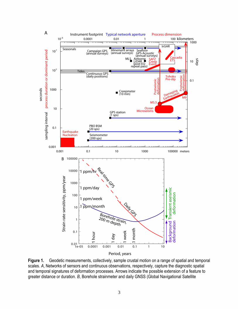
Figure 1. Geodetic measurements, collectively, sample crustal motion on a range of spatial and temporal scales. A, Networks of sensors and continuous observations, respectively, capture the diagnostic spatial and temporal signatures of deformation processes. Arrows indicate the possible extension of a feature to greater distance or duration. B, Borehole strainmeter and daily GNSS (Global Navigational Satellite

4
System) positions provide complementary sensitivity for transient and longer-term processes. Sub-daily GNSS positions, while less sensitive, allow for tracking coseismic displacement in real time. Approximate sensitivity and period in hours to months indicated on plot. GPS, Global Positioning System; InSAR, interferometric synthetic aperture radar; ETS, episodic tremor and slip; SAFZ, San Andreas Fault Zone; EQ, earthquake; MLS, mobile laser scanning; M, earthquake magnitude; min, minute; sps, samples per second; PBO, Plate Boundary Observatory; BSM, borehole strainmeter; ppm, parts per million.
Geodesy in the Context of NEHRP and NHMA Objectives
Within the National Earthquake Hazards Reduction Program (NEHRP), the primary
objectives of the Earthquake Hazards Program (EHP) are: provide quantitative assessments of
earthquake hazards to improve earthquake-resistant building design and construction practices;
monitor and report on earthquake activity worldwide and provide timely reports of possible
effects; develop systems to warn of imminent shaking (that is, earthquake early warning);
conduct and support research to improve our hazard assessments, monitoring capabilities, and
the understanding of earthquake phenomena; and communicate earthquake hazards and risk to
decision-makers, emergency responders, and the general public. These objectives collectively
support the EHP’s overall mission to reduce losses during future earthquakes, and also are
closely linked to the Science Strategy of the USGS Natural Hazards Mission Area (NHMA;
Holmes and others, 2012). The NHMA sets out four goals, two of which focus on outcomes that
decision-makers and the public can use directly: providing information to enable effective
situational awareness before, during, and after natural disasters; and generating effective
assessment products and services. The other two goals, to provide enhanced observations and to
advance the fundamental understanding of hazards and impacts, concern the operational and
scientific efforts without which these outcomes cannot be realized. The EHP explicitly advances
the NHMA goals through scientifically rigorous assessments such as the National Seismic
Hazard Model (NSHM), widely used information products such as ShakeMap and PAGER, and
world-class research that draws upon diverse datasets.
Each of the EHP’s core monitoring and observational activities, such as geodesy,
seismology, paleoseismology, geology, and experimental rock mechanics, provides unique and
complementary input that is critical to advancing the program’s basic and applied research on
earthquake occurrence and effects. The monitoring networks funded by the EHP, the external
research partners we support, and additional institutions whose own activities are synergistic
with ours all help the USGS to meet its statutory responsibilities (Robert T. Stafford Disaster
Relief and Emergency Assistance Act, 42 U.S.C. § 5121 et seq.) to provide timely and accurate
information that enhances awareness and understanding of evolving earthquake hazards and
helps mitigate the effects of seismic activity.
This report focuses on the role of geodesy in reducing losses from earthquakes. Geodesy
encompasses a variety of measurements that record motion of the Earth’s surface and strain
within the shallow crust. Data sources include global navigational satellite systems1 (GNSS),
interferometric synthetic aperture radar (InSAR), borehole strainmeters (BSM), techniques for
measuring shallow fault offset (creepmeters, alignment arrays), and high resolution imagery
1 The Global Positioning System (GPS) is a subset of GNSS. Currently, many instrument networks and
processing software packages only support GPS. It is expected that they will include other satellite navigation
systems in the future. For simplicity, in this document we use GNSS to refer to both GPS-only and generic
GNSS systems.
5
(including optical imagery and repeat-pass lidar [light detection and ranging] from ground,
mobile, or airborne sensors). We also consider frontier geodetic techniques under development,
such as seafloor measurements and crowd-sourced observations from low-cost sensors.
Collectively, geodetic observations have unique capabilities for recording displacements
of millimeters to meters over distances of meters to thousands of kilometers, time-spans of
seconds to decades, and often in three dimensions and real-time (fig. 1). The intersection
between the rich data provided by geodetic observations and the scientific work central to the
EHP mission defines the geodesy-related efforts, both observational and research, to which
allocating resources will be most effective. The target outcomes and strategies described herein
include maintenance of mission-critical capabilities, growing new competencies where we are
well positioned to do so, working with partner institutions on topics of mutual interest, and
fostering new fundamental and applied research.
How Geodesy Contributes to the EHP’s Mission
Geodetic data provide unique information that contributes to successfully accomplishing
several of the EHP’s most important products and responsibilities pertaining to earthquake loss
reduction.
National Seismic Hazard Model
The NSHM, which quantifies the level of earthquake-related ground shaking anticipated
over a specified time period for locations nationwide, is one of the EHP’s most widely used
hazard assessment products. It is the basis for earthquake building codes and provides
information used by public officials, the insurance industry, the private sector, and the general
public to assess risk and better plan for future earthquakes. Earthquake rupture forecasts, a
principal input for the probabilistic seismic hazard assessment upon which the NSHM is based,
characterize possible earthquake sources in terms of their magnitudes, recurrence rates, and
location of the causative fault ruptures. Traditionally the dates and fault displacements of past
earthquakes, determined from geologic data, have provided the fault slip rate information for
earthquake rupture forecasts. Building on the Uniform California Earthquake Rupture Forecast,
version 3 (UCERF3; Field and others, 2013), the 2014 release of the NSHM (Petersen and
others, 2014) is the first to incorporate slip rates estimated from geodetic observations in the
western United States (fig. 2). The geodetic data reflect contemporary deformation rates, provide
slip rate information on additional faults that lack geologic rate estimates, help quantify broadly
distributed strain, and, in the future, may allow time-dependent forecasts to account for variation
in slip rates throughout the earthquake cycle (Bürgmann and Thatcher, 2013). In addition,
geodetic data are unique in their sensitivity to creep rates and spatially variable fault interface
coupling, including the down-dip limit of subduction zone locking, which are important factors
in forecasting the potential size of future earthquakes and resulting ground motions (Harris,
2017; Kanamori, 2014; Kaneko and others, 2010; Loveless, 2017; Loveless and Meade, 2011;
Roeloffs, 2015). For example, the depth at which aseismic slip occurs in subduction zone
episodic tremor and slip (ETS) events may delineate the down-dip extent of earthquake rupture
and can be constrained by borehole strainmeter data (fig. 3). Seafloor geodetic measurements, if
available, provide unique information to better characterize shallow megathrust strain
accumulation (Bürgmann and Chadwell, 2014; Nishimura and others, 2014; Yokota and others,
2016).

6
Figure 2. Moment rate predicted from the geodetically constrained deformation model used in UCERF3, the Uniform California Earthquake Rupture Forecast version 3. A fault’s slip rate reflects the relative motion that must occur across the fault to accommodate plate motion. Moment rate, obtained by multiplying slip rate, fault area, and shear modulus, quantifies the associated energy release. A, Moment rate on faults of the UCERF3 model. B, Moment rate associated with deformation not localized onto UCERF3 faults. Adapted from Parsons and others (2013). MoRate, moment rate; Nm/yr, Newton meters per year.
Figure 3. Cascadia episodic tremor and slip (ETS) events: using geodesy to map megathrust fault locking. Data from borehole strainmeters are sensitive to the up-dip extent of transient fault slip coincident with nonvolcanic tremor in subduction zones, as demonstrated for an ETS event that occurred in 2011 (Roeloffs, 2015). Slip in megathrust earthquakes is unlikely to penetrate large distances into areas of the
A B
7
fault that experience transient aseismic slip in ETS events, so the up-dip limit of ETS helps define the likely down-dip extent of megathrust ruptures. A–C, Maps showing cumulative number of tremor events from May 1, 2011 to July 7, 2011 (data retrieved from https://pnsn.org/tremor, last accessed May 30, 2017); black lines, contours of depth to the top of the subducting slab (in kilometers) (from McCrory and others, 2012); percent locking generalized from McCrory and others (2014). D, Forward model of evolving subduction megathrust slip at locations of tremor events predicts transient displacement (red line) at a continuous GPS (Global Positioning System) site, CHZZ, of the Plate Boundary Observatory (PBO). The number of tremor events is used as a proxy for the amount of slip, and the amplitude of modeled slip is scaled such that predicted displacement matches that recorded at CHZZ (black dots with 1 standard deviation error bars). Dashed vertical lines correspond to dates depicted in A–C. E, Differential extension (red) and engineering shear strain (blue) observed (solid lines) at PBO borehole strainmeter B024 and predicted (dots) from forward-modeled slip. Dashed red and blue lines show predicted strain if hypothetical transient slip is shifted up-dip such that it occurs completely off shore, which would imply a shallower down-dip limit of slip in megathrust earthquakes. BSM, borehole strainmeter; km, kilometers; mm, millimeters; %, percent; ppm, parts per million. BSM and GPS data were provided by the Plate Boundary Observatory operated by UNAVCO for EarthScope (www.earthscope.org) and supported by the National Science Foundation No. EAR-0350028 and EAR-0732947.
Earthquake Early Warning
Earthquake early warning (EEW) involves predicting shaking intensity at user locations.
This ground motion prediction often depends upon accurate, real-time determination of
earthquake source characteristics including location, magnitude, fault orientation, moment
release, and slip distribution. Real-time GNSS instruments directly measure coseismic
displacement and, unlike seismic data, can provide magnitude estimates that do not saturate for
very large earthquakes (Bock and Melgar, 2016). For earthquakes with magnitudes exceeding
approximately M7.5, finite fault modeling algorithms that use GNSS data might improve upon
EEW alerts by allowing more detailed characterization of the distance between the earthquake
rupture and user locations which, along with the estimated magnitude, influences the accuracy of
predicted shaking intensity (Crowell and others, 2016; Grapenthin and others, 2014; Minson and
others, 2014; fig. 4). ShakeAlert, the EEW system under development for the United States west
coast, released its production prototype in February 2016, and work is in progress to evaluate
algorithms utilizing real-time GNSS data for possible incorporation.
Earthquake Forecasting
Forecasting earthquakes requires robust information about time-dependent earthquake
probabilities to help decision-makers evaluate risks and take appropriate actions to mitigate the
effects of possible seismic activity. Currently, the EHP is developing operational aftershock
forecasts that use a statistical evaluation of the seismicity rate in an ongoing aftershock sequence
combined with information regarding the long-term probability of earthquakes in the affected
region (Field and others, 2016). During aftershock sequences, geodetic data record aseismic
deformation with moment release that typically exceeds the cumulative seismic moment. In
addition, spontaneous and triggered transient fault slip has been inferred using geodetic data in a
variety of settings, notably subduction zones, and triggering of earthquakes by transient slip has
been suggested in some cases (Obara and Kato, 2016; Uchida and others, 2016). It is not yet
known whether periods of transient aseismic deformation consistently correlate with changes in
earthquake likelihood. However, the spatially dense, broad geographic coverage of continuous

8
GNSS (cGNSS) networks and the high sensitivity of borehole strainmeters yield data that could
be systematically monitored for anomalous behavior, which could illuminate the relation
between transient deformation and seismicity and potentially improve forecasting tools.
Figure 4. Algorithms that use real-time GNSS (global navigational satellite systems) data can provide more accurate magnitude estimates than seismic data alone, and can constrain fault orientation and rupture extent, as demonstrated here using data from a Mw 9 earthquake in Japan. A, Slip distribution (colored squares) for the 2011 magnitude Mw 9 Tohoku-Oki earthquake estimated in simulated real-time analysis of displacements derived from high-rate GNSS data (black vectors) at 180 seconds after the earthquake origin time (Minson and others, 2014). The model identifies the best-fitting fault strike and dip, and the inferred slip distribution on a fault with this orientation defines the rupture extent. These parameters are re-estimated as new data arrive (as rapidly as once per second); the slip shown here is that estimated at 180 seconds past the earthquake origin time and has a corresponding moment magnitude (Mw) of 8.9. Inset: standard deviation (meters) of estimated strike slip (top) and dip slip (bottom) from Bayesian inversion. Red vectors are GNSS displacement at 180 seconds post origin-time predicted from model. km, kilometers; m, meters. Saw teeth mark subduction zone trench, with saw teeth on downgoing slab. B, Tohoku-Oki magnitude estimates from finite fault models constrained by different GNSS datasets (lines) and from seismic data (stars). Magnitudes derived from seismic data significantly under-estimate the true magnitude, Mw9. Grey, post-processed GNSS data; black, simulated real-time analysis of high-rate GNSS data (Minson and others, 2014); red, simulated real-time GNSS data analysis using observations and processing techniques typical of the quality available from consumer-grade GNSS units (Minson and others, 2015); purple stars, Japan Meteorological Authority’s real-time analysis of seismic data; blue star, magnitude estimated by the U.S. Geological Survey National Earthquake Information Center.

9
Situational Awareness
The availability of information regarding the cause, immediate effects, and evolving
aftermath of an earthquake improves situational awareness—the understanding of current
conditions and what to expect. By rapidly synthesizing observations and analyses from a variety
of sources, we can provide information to the public and officials to guide response efforts in the
seconds to weeks after an earthquake or during periods of anomalous activity, such as seismic
swarms or aseismic changes in deformation rates. High quality, timely information regarding
ongoing hazards increases the likelihood that losses will be reduced through effective mitigating
actions.
Following major earthquakes, the EHP generates a suite of earthquake response products,
which are updated as new data come in (Hayes and others, 2011). Geodetic observations
contribute unique information (Barnhart and others, 2015), especially through the integrated use
of traditional and newer techniques (fig. 5). Only geodetic data can record the evolution of
postseismic motion observed in the hours to years following major seismic events. This
deformation reflects fault frictional properties, crust and upper mantle rheology, and the
redistribution of pore fluids due to earthquake-imposed stress changes (Bürgmann and Thatcher,
2013). Surface fault rupture and offset, including coastal elevation changes due to subduction
zone earthquakes, may damage lifelines and impact rebuilding and future land use. Combining
multiple observation strategies allows efficient characterization of damage to guide recovery and
anticipate total losses (Brooks and others, 2013; DeLong and others, 2015; Hudnut and others,
2014, Liberty and others, 2013; Sun and others, 2017). Such observations include rapid, repeated
post-earthquake imagery from satellite and airborne platforms, along with high-resolution
seafloor bathymetry, paired with pre-event data. GNSS measurement of ongoing surface motion
in three dimensions is a vitally important complement to imagery data. The expanded availability
of real-time GNSS data and SAR imagery with frequent repeat passes presents new
opportunities. If used to its fullest, geodesy could enable a true temporal continuum of
earthquake response information, providing a bridge from EEW alerts to rapid damage
assessment and longer-term planning of recovery efforts.
Geodetic data further support awareness of potential seismic threats by recording
transient, aseismic variation in deformation rates that may reflect changing fault zone conditions.
When monitoring networks detect anomalous seismic or geodetic signals , EHP scientists are
called upon to assess the possibility that the anomalous observations herald the imminent
occurrence of a damaging earthquake (Roeloffs and Goltz, 2017). A better understanding of the
relationship between geodetically observed transient deformation and the fault zone processes
that control earthquake occurrence is required to guide the development of appropriate public
messaging in response to such events.
Finally, seafloor geodetic methods have successfully recorded coseismic offsets (Sato
and others, 2011), postseismic motion (Ohta and others, 2012; Yamagiwa and others, 2015), and
deformation during slow slip events (Ito and others, 2013; Sato and others, 2017; Wallace and
others, 2016). If continuously recorded and telemetered, such observations would enhance
tsunami warning, post-earthquake recovery, and interseismic monitoring capabilities for
subduction zones in the future.
10

11

12
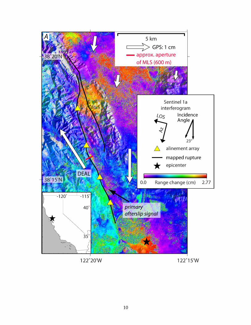
Figure 5. The August 24, 2014, magnitude 6 South Napa earthquake showcased the joint use of traditional and new geodetic observation techniques to comprehensively characterize evolving conditions and aid post-earthquake recovery (Hudnut and others, 2014). A, Postseismic deformation in the area of the South Napa earthquake (epicenter marked by black star), August 31–October 6, 2014, recorded by the European Space Agency’s recently launched Sentinel 1a satellite. White arrows are vectors of

13
displacement measured using global navigational satellite systems (GNSS) during the observation period. MLS, mobile laser scanning; LOS, line-of-sight; Az, azimuth of satellite motion relative to ground. B, Periodic alignment array measurements recorded accumulating right-lateral displacement at the fault trace (Lienkaemper and others, 2016). NW, northwest; cm, centimeters; km, kilometers. C, To augment continuous GNSS (cGNSS) data, U.S. Geological Survey scientists deployed campaign GNSS equipment in semi-permanent mode to track evolving afterslip (Floyd and others, 2016). Post-earthquake position time series for campaign GNSS site DEAL, shown with 2-standard-deviation error bars, exhibit a decelerating afterslip signal. mm, millimeters. D, Repeated mobile laser scanning (MLS) measurement of vineyard rows recorded surface offsets in unprecedented detail, demonstrating this new measurement technique’s utility (Brooks and others, 2017). While fault offset of the vine rows is visually apparent (white dashed line with arrows indicating sense of slip in photo), the maneuverable truck-mounted laser scanner enables scanning small-scale deformation features from multiple angles. Geometric analysis of the point cloud data acquired during repeated scans of the same objects, here vineyard rows, allows precise measurement of evolving offsets, depicted as a function of fault-normal distance by the grey dots. E, left, time series of data from a borehole strainmeter (Ohlone, OH) measure three components (color-coded for clarity) of the horizontal strain tensor, providing both coseismic offsets and postseismic strain records. Right, Coseismic shear strain observations, shown in map view by color coded circles at instrument locations, help constrain coseismic source models. Star, South Napa earthquake epicenter; blue lines, major, active faults. Background shading depicts strain field predicted from best-fitting model; color scale saturates at ±300 ppb (Langbein, 2015). ppb, parts per billion; Eee-Enn, 2Een, two components of shear strain recorded by instrument. Sentinel 1a data were provided by the European Space Agency (ESA)’s Copernicus Programme.
Earthquake Triggering and Induced Seismicity
Fluid extraction and injection, as well as hydrologic loading, occur in a variety of
geographic regions; however, such processes appear to trigger earthquakes in only a small
fraction of these locations (Ellsworth, 2013). Because BSM, InSAR, and other geodetic
techniques can record crustal deformation related to these processes, geodesy could help identify
factors that influence induced earthquakes in some geologic settings. Geodetic monitoring in
susceptible regions may provide constraints for elucidating the underlying physics and for
tracking evolving hazard (see, for example, Barnhart and others, 2014).
Envisioned Outcomes for Geodesy
We anticipate that by capitalizing on the unique insight that geodetic information brings
to key EHP activities and the potential value added by new and anticipated geodetic techniques,
the EHP geodesy program could successfully realize the following outcomes:
1. The EHP serves as an authoritative source for the interpretation of geodetic data and its
use for earthquake loss reduction throughout the United States and its territories.
2. The USGS consistently provides timely, high-quality geodetic data to stakeholders.
3. Significant earthquakes are better characterized by incorporating geodetic data into
USGS event response products and by expanded use of geodetic imaging data to assess
fault rupture and source parameters.
4. Uncertainties in the NSHM and in regional earthquake models, are reduced by fully
incorporating geodetic data into earthquake probability calculations.

14
5. Geodetic networks and data are integrated into the operations and earthquake information
products of the Advanced National Seismic System (ANSS).
6. Earthquake early warnings are improved by more rapidly assessing ground displacement
and the dynamic faulting process for the largest earthquakes using real-time geodetic
data.
7. Earthquake forecasting methodology is refined by including geodetic data when
calculating evolving moment release during aftershock sequences and by a better
understanding of the implications of transient deformation for earthquake likelihood.
Achieving these objectives would require a combination of research and operational activities. In
the following sections we summarize the Earthquake Hazards Program’s current capabilities,
discuss critical partnerships, and define strategies that will guide the EHP to these outcomes.
Current Capabilities
Geodetic Observations
The observational component of the EHP’s geodesy program has four elements:
continuous data collection, collection of ephemeral data, targeted data collection, and data
analysis. Obtaining raw data, processing, and analyzing them to produce inputs useable for
follow-on investigations and monitoring applications are central to the EHP’s ability to use
geodesy to advance its research, hazard assessment, and situational awareness efforts.
Continuous Data Collection
Networks of instruments that operate and transmit data continuously ensure, to the
greatest degree possible, the collection of data that spans all stages of the earthquake cycle. Such
networks make it possible to fully record evolving postseismic processes, both to guide event
response and for research. They also increase the likelihood of recording unanticipated events or,
potentially, preseismic deformation. The incorporation of geodetic observations into products for
immediate post-earthquake response and the potential inclusion of geodesy in the ShakeAlert
earthquake early warning system impose concrete requirements for robust real-time GNSS data
acquisition. BSM data, if available in real-time, could enable future enhancements to EEW in
some geographic regions (Barbour and Crowell, 2017). Low-cost seismogeodetic sensors that
provide both GNSS and accelerometer recordings may enable EEW for large earthquakes in
regions where monitoring with dense observatory-grade networks is not practical and could
augment alerting capabilities in well-instrumented regions, for example by enabling more
accurate rapid magnitude estimates as shown in fig. 4B (Minson and others, 2015).
The EHP currently operates cGNSS networks in the San Francisco Bay Area and
southern California, providing the primary coverage for the southern San Andreas Fault and the
greater Los Angeles area (fig. 6). Most sites in both networks provide real-time data, and many
are collocated with seismic instruments. The EHP also operates creepmeters and borehole
dilatometers to provide high-resolution measurements of coseismic offsets and the evolution of
afterslip for future Hayward Fault earthquakes (fig. 7).

15
Figure 6. Continuously recording GNSS (global navigational satellite system; cGNSS) sites operated by the U.S. Geological Survey’s Earthquake Hazards Program (EHP) and partners funded by the EHP. Left, map showing station distribution in the western United States (red outline in inset map shows area covered). Red lines are historical and Holocene active faults (USGS, 2006); red line with saw teeth denotes megathrust fault of the Cascadia Subduction Zone, saw teeth on downgoing slab. Right, map of the EHP-supported stations that monitor the New Madrid seismic zone in Missouri, Tennessee, and Arkansas.
Figure 7. Map of geodetic monitoring instruments in the San Francisco Bay Area, California. Red lines are historical and Holocene active faults (USGS, 2006). cGNSS, continuous global navigational satellite system instrument; EHP, Earthquake Hazards Program of the U.S. Geological Survey; km, kilometers.

16
Collection of Ephemeral Data
Temporary instrument deployments, for example campaign GNSS surveys, mobile laser
scanning (MLS), and collection of post-event imagery and bathymetry, augment continuous
networks by enabling expanded observation of transient crustal motion. The resulting data
contribute to improved understanding of evolving conditions during spontaneous deformation
events and after earthquakes. They also provide input for future research, including applications
not yet envisioned. Recently launched SAR (synthetic aperture radar) satellites like the European
Space Agency’s Sentinel 1a and 1b, and other missions in the planning stages, are ushering in an
era in which frequent repeat passes over a given location provide sufficient temporal sampling to
track the spatial patterns of transient deformation in detail.
By maintaining an active field crew, modern geodetic instrumentation, and specialized
field equipment, the EHP is well positioned to carry out effective and immediate post-earthquake
data collection in some of the most seismically active regions of the country. In recent years we
have responded to the 2004 Parkfield, California, 2008 Wells, Nevada, and 2014 South Napa,
California, earthquakes, collecting data central to improved understanding of coseismic source
properties, postseismic processes, and fault zone characteristics that control deformation (Floyd
et al., 2016; Hammond et al., 2011; Murray et al., 2006). Recent in-house research and
development is adding new capabilities such as MLS to our toolbox. Application of this
technique following the South Napa earthquake (Brooks and others, 2017) produced near-fault
deformation measurements of unprecedented resolution, shedding new light on the way in which
earthquake rupture is manifest at the earth’s surface (fig. 5). To expand earthquake response
capabilities, we have also implemented automatic download and processing of sSentinel InSAR
data for all earthquakes of M>4.5 in the western United States.
Targeted Data Collection
The staff and facility resources that position us well for earthquake response also enable
us to design and carry out targeted data collection in support of basic research and externally
funded projects. Over several decades, the USGS has cultivated an extensive network of
campaign GNSS sites (fig. 8) and alignment arrays throughout the western United States for
which we continue to build a database of high quality observations (McFarland and others, 2016;
Murray and Svarc, 2017). New efforts are underway to develop spatially dense datasets through
periodic MLS campaigns, which can be used to calculate fault creep rates. EHP scientists are
also applying paleogeodetic methods, in which sedimentary fossil assemblages and tsunami
deposits are used to map spatial patterns of earthquake-induced uplift and subsidence, to shed
light on the rupture extent of great earthquakes in the Aleutian and Cascadian Subduction Zones
(Milker and others, 2016; Nelson and others, 2008; Witter and others, 2012; Witter and others,
2016). We leverage GNSS, InSAR, and other geodetic data in public archives to complement the
geodetic measurements we collect.
EHP research staff also participate in international collaborations that foster data sharing
among agencies. In particular, we draw upon SAR interferometry data collected by several
nations’ space agencies to characterize and develop models that describe deformation processes
including seismic swarms, induced seismicity, and postseismic relaxation. The more frequent
repeat passes of newly launched SAR satellites enable improved time series analysis and
reduction of atmospheric noise, thereby expanding the geographic regions over which InSAR
might be used to measure fault-related deformation. With additional personnel skilled in InSAR
processing, time series analysis, and interpretation, the EHP could fully harness the wealth of

17
data generated by new and anticipated SAR missions and, in turn, improve deformation
monitoring, investigation of underlying processes, and post-earthquake information products.
Figure 8. Map of the western United States showing EHP campaign GNSS (global navigational satellite system) data collection sites, color-coded by year of most recent EHP occupation. Map also shows semi-permanent GNSS sites supported by the Earthquake Hazards Program (EHP). Thin red lines are historical and Holocene active faults (USGS, 2006); thicker red line with saw teeth is the Cascadia megathrust fault, with saw teeth on downgoing slab.

18
Data Analysis
The raw geodetic measurements resulting from the EHP’s GNSS, strainmeter, and
creepmeter field monitoring are archived at the publicly accessible Northern California
Earthquake Data Center (northern California cGNSS sites, strainmeters, creepmeters) and
UNAVCO (southern California cGNSS sites). Documentation, cleaned data, and derived
products are available through the EHP website
(https://earthquake.usgs.gov/monitoring/deformation/).
Raw measurements must undergo processing and analysis to derive geophysically
meaningful observations such as displacements or velocities. The EHP has built automated
systems that use computational software (both internally and externally developed) to conduct
this work in-house (Murray and Svarc, 2017), ensuring timely access to the data needed for
earthquake response, enabling full understanding of inputs used for follow-on research, and
permitting EHP scientists to tailor the analysis approach to specific applications. We continually
work to streamline data acquisition and processing operations. The Earthquake Science Center
(ESC) has implemented uniform daily processing and automatic web display of data from the
cGNSS networks that the EHP supports (internally and externally), as well as data from Plate
Boundary Observatory (PBO) stations throughout the western United States. The EHP has also
taken the first steps to establish GNSS data processing capabilities at the National Earthquake
Information Center (NEIC) for global earthquake response. By combining software written in-
house for data acquisition, quality control, and network monitoring with commercial data
processing software, the ESC has built the computational infrastructure needed to ensure the
availability of real-time GNSS observations for EEW and other applications central to the EHP
mission.
Research
In concert with these observational activities, EHP scientists utilize geodetic data for
investigations that span the continuum from fundamental to applied research. Topically, our
current work focuses on quantification of interseismic slip rates, strain rates, and the spatial
distribution of fault coupling in the seismogenic zone; detection and characterization of transient
signals; modeling the mechanisms underlying postseismic deformation at all spatial and temporal
scales; and inferring earthquake source characteristics through static and kinematic modeling that
provides input for follow-on investigations, post-earthquake response, and EEW.
Much of this work centers on a subset of the seismotectonic regions within the purview
of the EHP mission, in particular the San Andreas Fault System in central and northern
California, the Eastern California Shear Zone, the Cascadia Subduction Zone, and the Basin and
Range Province. The EHP also draws upon data from other regions worldwide, for example
Japan, Chile, and Turkey, that record deformation processes analogous to or potentially affecting
the United States and its territories. We strive to build and maintain relationships with
international colleagues to facilitate collaborations on topics of mutual interest.
EHP scientists lead research and development of new observational and analysis
techniques, such as construction of low-cost instrument packages for real-time earthquake
response and testing of new methods for high-resolution imaging. Experience with seafloor
geodetic methods is a current personnel resource that could support future efforts. Computational
strengths include application of viscoelasticity and rate and state friction for modeling
deformation mechanisms, data assimilation for tracking time-varying processes, pattern
19
recognition techniques for isolating signals of interest, and Bayesian methods for more complete
characterization of uncertainties.
Renewing our expertise in real-time GNSS processing and analysis, quantitative
assessment of complex noise processes affecting geodetic data, rigorous evaluation of data
quality, BSM data analysis and monitoring, and investigating deformation of the southern San
Andreas Fault System could provide a solid foundation for EHP leadership on topics central to
the program’s goals. Deformation in the central and eastern United States and Alaska, detailed
examination of vertical crustal motion, and the application of geodesy for induced seismicity
studies, while relevant to the EHP mission, are currently the focus of limited internal research.
Partnerships
The research and observational outcomes described in this document would be advanced
by leveraging the unique contributions that geodesy can make. Some geodetic efforts are
optimally accomplished through partnerships. This section considers such activities and
highlights external dependencies that potentially affect our geodesy program.
Data Collection and Operations
Continuously Operating Geodetic Networks
The EHP has a multi-pronged strategy to ensure the availability of continuous geodetic
data for all regions within the scope of its monitoring, response, and research activities. This
consists of network operations and maintenance conducted by the EHP, and we augment these
efforts in several ways.
The EHP has long-standing cooperative agreements that fund external partners to operate
cGNSS networks (fig. 6) in the New Madrid Seismic Zone, San Francisco Bay Area, and
Pacific Northwest (with the latter two providing real-time data) as well as Bay Area
BSMs (fig. 7). Standards and archiving requirements for cooperator networks have been
established and are continually updated to reflect evolving capabilities and needs (see
https://earthquake.usgs.gov/monitoring/anss/docs/Geodetic_Networks_Standards_Proced
ures.pdf). The role of cooperators in supporting real-time GNSS data acquisition may
grow under the auspices of ShakeAlert. Geodetic instrument coverage in the central and
eastern United States is sparse outside the New Madrid Seismic Zone. Decadal time
series from an expanded, high-quality, permanent GNSS network could help significantly
in fully quantifying deformation across this region (Hamburger and others, 2014).
The EHP is transitioning to joint network operations for collocated seismic and geodetic
(GNSS and BSM) sites, where possible, to maximize operational efficiency and enable
combined use of complementary observations. In planning future network
upgrades/expansion, we take into consideration that combined seismic-GNSS network
operations may become the ANSS standard in the future (U.S. Geological Survey, 2017).
We use freely available data from the National Science Foundation (NSF)-funded PBO
network, the single largest cGNSS and BSM network in the western United States, which
is run by the UNAVCO geodetic research, education, and operations consortium. Many
of the PBO GNSS stations now transmit real-time data.
The NEIC builds partnerships with GNSS network operators worldwide to ensure the
availability of data used in event response information products for earthquakes globally.

20
Low-cost instrument packages that integrate GNSS sensors and accelerometers,
combined with purpose-built software, have been developed by EHP scientists with the
goal of deployment in large, dense networks for EEW and tsunami warning applications.
In collaboration with international partners, these instruments are undergoing testing in
seismically active subduction zones (Brooks and others, 2017).
Reliance on data provided by outside institutions is not without risk. For example,
changes to management structure or network operation and maintenance policies at institutions
from which EHP obtains data have the potential to substantially alter the network footprint, data
collection practices, and accessibility of measurements. An example of such risk is the
conclusion of NSF's EarthScope initiative in 2018 which has, thus far, supported the operation of
PBO geodetic infrastructure. Consideration of such impacts and the overall costs and benefits of
available data sources can continue to inform the design of EHP monitoring and earthquake
response strategies. Drawing upon a variety of data sources can enhance resilience to change and
maximize ability to leverage new observational opportunities.
Geodetic Field Deployments to Measure Crustal Deformation
In addition to operating and monitoring data from continuous geodetic networks, we
expand the variety and quantity of observations available to inform EHP science by participating
in and supporting temporary field deployments. For example:
GNSS data collection is an important component of the USGS Volcano Hazards Program
(VHP) monitoring and research activities. EHP personnel assist the VHP with campaign
GNSS deployments in locations of mutual interest where the resulting data will
contribute to regional tectonic studies relevant to seismic hazard assessment.
Through our external funding to university partners for geodetic networks, we support
ongoing alignment array surveys in northern California (McFarland and others, 2016) and
operation of semi-permanent GNSS sites in the Basin and Range Province (fig. 8; Blewitt
and others, 2009). Campaign GNSS data collection is also occasionally supported
through the EHP external research grants for specific projects.
In some regions such as Alaska, the EHP primarily draws upon publicly available
continuous data and campaign GNSS observations collected and published by
universities, both funded largely through non-EHP sources.
While both EHP and university partners acquire and use post-event data for research
investigations of interest, our dedicated field capabilities directly support the USGS
responsibility for providing time critical information to support a variety of stakeholders in their
response and recovery activities. It is incumbent upon the EHP to maintain close coordination
with our university partners, UNAVCO, and the Southern California Earthquake Center (SCEC)
to promote exchange of data and avoid duplication of effort.
GNSS Data Processing
Our in-house GNSS data processing provides autonomy and flexibility to meet our
earthquake response requirements but depends critically on information from external
organizations, both domestic and international. These groups supply ancillary data, models, and
reference frames required for high-precision GNSS processing; archive data; and maintain
multiple software modules for GNSS data translation, quality control, and positioning. The
benefits of leveraging these well-developed, community-vetted tools outweigh the potential costs

21
of dependency. We obtain these inputs over the internet. By implementing robust
communications infrastructure, the EHP could ensure access to this vital information in the
aftermath of a major earthquake.
The EHP works actively with ShakeAlert partners and outside agencies to implement
real-time GNSS data processing and transmission for potential use in EEW and tsunami warning.
The use of GNSS data for these time-sensitive purposes has required establishing common
standards and protocols. Currently the EHP primarily uses commercial real-time software for
positioning and calculation of clock corrections, but open-source absolute positioning software
and freely available real-time clock corrections provided by the International GNSS Service are
now available, and the variety of commercial solutions for on-receiver real-time positioning is
expanding. By continuing to evaluate our real-time GNSS strategy, we can identify solutions that
offer cost savings and increased resiliency.
Topographic Data and Imagery
Various agencies collect, archive, and distribute satellite and airborne imagery used by
the EHP for research and earthquake response. These include lidar (light detection and ranging),
optical imagery, and SAR data. The EHP has assembled funding sources, collaborations, and
partnerships that facilitate data access, for example, through coordination with National Center
for Airborne Laser Mapping, membership in the Western North America InSAR Consortium,
and involvement in the planning for future SAR missions such as the anticipated United States-
India NISAR satellite. NISAR (NASA-ISRO synthetic aperture radar) is a collaboration
between NASA, the National Aeronautics and Space Administration, and ISRO, the Indian
Space Research Organization, slated for launch in 2020. The Sentinel 1a and 1b satellites are
now producing freely available data with repeat pass intervals as short as six days. While we
have in-house expertise for processing of raw SAR, lidar, and other imagery data to obtain the
deformation measurements required for research and event-response applications, we utilize
externally developed software, both commercial and open-source, for this work. Bathymetric
surveys of seafloor topography, particularly in deeper water, require collaboration with the
academic community, international partners, and the National Ocean and Atmospheric
Administration (NOAA).
Research
Recognizing that scientific advances arise when investigators bring to bear a variety of
approaches, expertise, perspectives, and resources, the EHP strives to address the full breadth of
basic and applied research required to meet its loss reduction objectives through multiple
avenues. These include internally-funded work by EHP scientists; work by EHP scientists who
have obtained funding through cooperative agreements and grants from other institutions,
government agencies, and the private sector; and work of scientists outside USGS who are
funded through SCEC and the EHP’s external research grants.
Through collaborations we can pool resources such as computing, laboratory, or
instrument testing facilities and undertake large-scale observational and research efforts that
would be intractable for an individual institution to pursue. The USGS Subduction Zone Science
Plan (Gomberg and others, 2017) fosters interdisciplinary research that furthers our basic
understanding of subduction zone processes and our ability to respond to the associated natural
hazards. Geodetic observations are central to this effort, providing a means for recording
transient signals and three dimensional deformation potentially at all stages of the earthquake

22
cycle both onshore and offshore. A shared interest in topics such as subduction zone processes,
seafloor geodetic monitoring, and near-real-time geodesy for rapid tsunami characterization
presents opportunities to collaborate on initiatives funded by other agencies such as NSF, NASA,
and NOAA (see, for example, McGuire and others, 2017).
Approaches for Advancing Geodetic Outcomes
The following targeted actions would represent tangible progress toward several of the
envisioned outcomes for the EHP geodesy program that were described earlier in this report:
Build the next generation of geodetically constrained interseismic deformation models
and incorporate them into UCERF and the NSHM. Leverage the latest theoretical
research and methodological advances to address issues outlined in appendix 1.
Develop algorithms that combine real-time and near-real-time geodetic observations with
other data types to enhance EEW, tsunami warning, maps of peak ground displacement,
and afterslip forecasting as part of a temporally evolving continuum of well-integrated
information released following seismic events. Implement within EHP production
systems all methods that provide demonstrable improvement to our products and
services.
Expand the role of geodesy in earthquake response products such as maps of surface
rupture, seafloor displacement, and disruptions to fault-crossing lifelines including roads
and utilities to improve situational awareness and to aid in earthquake recovery.
Determine whether transient deformation observations can effectively inform earthquake
likelihood estimates; if so, incorporate such observations into operational earthquake
forecasts.
Steady progress toward the priority outcomes would be bolstered by sustaining the four elements
of our observational geodesy program:
Operate robust networks of GNSS stations and targeted creepmeter networks, and
leverage continuous geodetic networks operated by other institutions, to enable effective
monitoring, event response, and study of time-dependent processes.
Capture ephemeral observations of evolving processes, including spontaneous transient
signals and postseismic deformation, to augment data from continuously recording
networks.
Conduct targeted data collection, for example through field deployments, mining of data
archives, bathymetric surveying, or tasking data acquisition from satellite and airborne
platforms to obtain observations in support of current and future research efforts critical
to the EHP mission.
Utilize automated and customized data processing, calculation of derived quantities,
visual display, and dissemination of results to promote data discovery and usability
across the spectrum of target applications.
The envisioned geodetic outcomes could be achieved through coordinated research and
observation strategies, as detailed here.
Through fundamental research we can advance our understanding of physical processes that
influence the time and location of earthquake occurrence and the size to which a rupture
grows.—Geodetic data can be used in combination with models that incorporate mechanisms
such as rate and state friction, plasticity, and viscoelasticity to develop a comprehensive

23
description of evolving deformation and stress within and over successive earthquake cycles.
Such models have direct relevance to the next generation NSHM, adding a geodetic component
to EEW, advancing operational earthquake forecasting methods, and creating better products to
guide response to and recovery from seismic events.
The development of modeling methods that fully and accurately quantify parameter
uncertainties is critical for objective integration of results into probabilistic analyses and will
ultimately lead to more informative products. Analysis and modeling approaches that harness
high-performance computing, cloud computing, and data mining opportunities hold great
potential for accelerating research efforts.
Specific research activities designed to help meet our target outcomes can be accomplished
through a combination of internal research and collaboration with external partners.—While
EHP scientists possess the expertise required to carry out a broad range of crustal deformation
research, only a subset of this work can be addressed given current research staffing levels. The
following strategy could facilitate addressing research needs:
Implement a balanced portfolio of internal research that directs effort toward the target
actions identified above while allowing scientists to explore new ideas and develop novel
approaches relevant to the EHP mission. Draw upon the existing EHP topical and
regional strengths outlined earlier, refocusing efforts as appropriate to address the needs
of the NSHM, EEW, operational earthquake forecasts, response to earthquakes or the
detection of anomalous signals, and comprehensive subduction zone studies. Undertake
only those reimbursable projects that most directly align with the objectives stated in this
report.
Make research hires to address deficiencies in topical and regional expertise in order to
fulfill our statutory responsibility to provide authoritative information on earthquakes,
maintain our leadership position in earthquake science, realize the full potential of new
initiatives, and ensure our responsiveness to stakeholder needs.
Fund cooperative agreements to support scientific investigations that complement
ongoing internal research, strengthen EHP products by incorporating alternative
perspectives and approaches, or address topics we cannot adequately cover internally.
Examples include expanded modeling of active processes in Alaska and the central and
eastern United States, development of additional deformation models for the NSHM,
further investigation of the physical processes governing aseismic slip, detailed
characterization of vertical crustal motion, and geodetic studies relevant to induced
seismicity.
Maintaining a vibrant internal research program is critical to meeting EHP priorities.—Doing
so sustains in EHP scientists a high-level understanding of fundamental research questions and,
thus, the ability to effectively discriminate among research findings from a variety of sources, to
identify missing components, and to design new studies to address questions that limit the
effectiveness of our products. Such knowledge is required to evaluate the results of work we
fund at cooperator institutions and to assimilate the best available science into widely used
products and services such as the NSHM, operational earthquake forecasts, and EEW for which
USGS has primary responsibility.
EHP scientists fill a critical role in enabling USGS to meet its statutory obligations as an
authority on earthquake activity. Quickly providing informed interpretation and assessment of
24
anomalous geodetic observations that may be associated with increased earthquake likelihood
requires scientists with a synoptic understanding of the relevant technical, physical, and regional
aspects of deformation sources and signals. If we cannot provide timely, trusted information,
stakeholders will look elsewhere, diminishing the stature and relevance of our organization.
We can position ourselves well for the future.—In order to maintain our standing and
effectiveness, we can engage in efforts, both internal and external, that ensure the availability of
data on which we rely, promote more robust and efficient operations, foster the development and
application of innovative techniques and novel ways to use existing data to support our mission,
and bring new users to our science. Aligning the EHP’s ongoing and future geodetic
infrastructure investment with the target outcomes and specific activities described in this report
would most effectively support and advance the EHP mission. The following section discusses
the role of personnel resources in enabling these efforts. Appendix 2 provides a detailed
description of observational activities and applied research that could sustain forward
momentum. Here we highlight three initiatives that, if given timely attention, could help ensure
we provide the best possible information and assessments in support of actions to mitigate
earthquake losses.
Fully utilize data from current SAR missions for rapid earthquake response, tracking
transient processes including afterslip, and measuring interseismic deformation; position
ourselves to extend these efforts to future SAR missions such as the NISAR satellite
mission.
Identify and take steps to address critical network operation and data management
dependencies, within our own systems and linked to external institutions, that affect our
ability to carry out our earthquake response, monitoring, and hazard assessment mandate.
Develop an actionable strategy to achieve affordable seafloor geodetic data collection
with sufficient spatiotemporal coverage and precision to infer interseismic strain rates,
quantify megathrust earthquake slip, and detect transient deformation to support
improved hazard assessment, monitoring, and rapid dissemination of comprehensive
information following earthquakes. Central to this effort is building a network of partners
in academia, government, and the private sector.
Staffing Needs
Through wise workforce planning the EHP can maximize its agility in addressing
evolving core and frontier activities. We currently face significant gaps in our ability to meet
operational responsibilities (appendix 2), carry out research upon which mission critical products
are built, satisfy the requirements of major new initiatives (such as the Subduction Zone Science
Plan [Gomberg and others, 2017], in which geodesy will play a key role), and catalyze the
advances envisioned by EHP scientists that are enabled by new resources such as large volumes
of freely available geodetic data. Retirements put competing demands on remaining personnel.
There is a particular need for technical staff who combine proficiency in quantitative analysis
with the basic geophysical knowledge necessary to routinely evaluate data and make preliminary
interpretations to support the EHP in carrying out both its situational awareness responsibilities
and ongoing research.
Broadening our capacity to develop and adopt cutting-edge geodetic methods is central to
sustaining a dynamic geodesy program. Leveraging advances such as cloud computing that offer
greater resiliency, efficiency, and cost savings require information technology skill sets that are
in short supply. Obtaining adequate system administrative, networking, and software
25
development support would safeguard progress on mission-critical projects. In parallel, research
hires that bring new capabilities to advance the EHP’s high profile products and that strengthen
our expertise for evaluating regional seismic hazard could help ensure that the EHP remains a
leader in the use of geodesy to realize earthquake loss reduction.
Personnel who contribute to multiple programmatic efforts by possessing broad
competencies and readily adapting their skills to varied and evolving organizational requirements
help the USGS be responsive, agile, and innovative. Therefore, in order to complement new
hiring, we can facilitate training of existing staff in new techniques, aid their transition to new
responsibilities, and nurture their exploration of new avenues for geodetic research. Identifying
shared needs among multiple disciplines at the science center, program, and mission area levels
might present additional paths to address gaps in expertise. While staff development may
prioritize fulfilling existing obligations for monitoring, alerting, and event response, pursuing
new internal funding initiatives and outside sources of salary support could foster frontier efforts.
Conclusion
This report presents the scientific rationale for and means of implementing strategies by
which the Earthquake Hazards Program (EHP) can utilize geodetic data to their fullest in
carrying out its mission to reduce losses from earthquakes. Geodetic observations provide unique
information for characterizing and monitoring interseismic strain accumulation, transient
aseismic deformation, and evolving earthquake rupture, in turn supporting improved seismic
hazard assessments, tools for enhanced situational awareness following earthquakes and during
periods of anomalous activity, and better-constrained earthquake early warning. Geodesy efforts
that encompass a balanced mix of activities that sustain mission-critical capabilities, grow new
competencies through the continuum of fundamental to applied research, and ensure sufficient
resources for these endeavors can support the EHP in meeting its core responsibilities and
realizing potentially game-changing advances envisioned by its scientists. Through these efforts,
the EHP can exploit abundant new geodetic data sources, evaluate and assimilate the latest
science, and pursue novel avenues of investigation. Central to the geodesy program’s success is
engaging personnel with a breadth of competencies, from technical to theoretical, and a
willingness and ability to adapt these to the EHP’s evolving priorities. In parallel, the program
can collaborate with external partners to support scientific investigations that complement
ongoing internal research and strengthen EHP products by incorporating alternative perspectives
and approaches.
References Cited
Barbour, A.J., and Crowell, B.W., 2017, Dynamic strains for earthquake source characterization:
Seismological Research Letters, v. 88, no. 2A, 354-370, doi:10.1785/0220160155, accessed
February 12, 2018, at
https://pubs.geoscienceworld.org/ssa/srl/article/88/2A/354/314232/dynamic-strains-for-
earthquake-source.
Barnhart, W.D., Benz, H.M., Hayes, G.P., Rubinstein, J.L., and Bergman, E., 2014,
Seismological and geodetic constraints on the 2011 Mw5.3 Trinidad, Colorado earthquake and
induced deformation in the Raton Basin: Journal of Geophysical Research, v. 119, p. 7923–
7933, doi:10.1002/2014JB011227, accessed February 12, 2018, at
http://onlinelibrary.wiley.com/doi/10.1002/2014JB011227/full.

26
Barnhart, W.D., Murray, J.R., Yun, S.-H., Svarc, J.L., Samsonov, S.V., Fielding, E.J., Brooks,
B.A., and Milillo, P., 2015, Geodetic constraints on the 2014 M6.0 South Napa earthquake:
Seismological Research Letters, v. 86, no. 2A, p. 335–343, doi:10.1785/0220140210, accessed
February 12, 2018, at
https://pubs.geoscienceworld.org/ssa/srl/article/86/2A/335/315485/geodetic-constraints-on-the-
2014-m-6-0-south-napa.
Blewitt, G., Hammond, W.C., and Kreemer. C., 2009, Geodetic constraints on contemporary
deformation in the northern Walker Lane—1. Semi‐permanent GPS strategy, in Oldow, J. S.,
and Cashman, P., eds., Late Cenozoic Structure and Evolution of the Great Basin–Sierra
Nevada Transition: Geological Society of America Special Paper 447, p. 1–15,
doi:10.1130/2009.2447(01), accessed February 12, 2018, at
https://pubs.geoscienceworld.org/books/book/602/chapter/3804700/geodetic-observation-of-
contemporary-deformation.
Bock, Y. and Melgar, D., 2016, Physical applications of GPS geodesy—a review: Reports on
Progress in Physics, v. 79, no. 10, art. no. 106801, 119 p.
Brooks, B.A., Glennie, C., Hudnut, K.W., Ericksen, T., and Hauser, D., 2013, Mobile laser
scanning applied to the earth sciences: Eos, Transactions of the American Geophysical Union,
v. 94, no. 36, p. 313–315, doi:10.1002/2013EO360002, accessed February 12, 2018 at
http://onlinelibrary.wiley.com/doi/10.1002/2013EO360002/epdf.
Brooks, B., Minson, S.E., Böse, M., Ericksen, T.K., Barrientos, S., Baez, J.C., Cochran, E.,
Smith, D., Duncan, C., Guillemot, C., Murray, J.R., Langbein, J.O., and Glennie, C.L., 2017,
Towards internet of things earthquake early warning—A pilot network in Chile [abs.]:
Seismological Research Letters, v. 88, no. 2B, p. 537, doi:10.1785/0220170035, accessed
February 15, 2018 at https://pubs.geoscienceworld.org/ssa/srl/article/88/2B/463/282941/ssa-
2017-annual-meeting-announcement-and-program.
Brooks, B.A., Minson, S.E., Glennie, C. L., Nevitt, J., Dawson, T., Rubin, R., Ericksen, T.L.,
Lockner, D., Hudnut, K., Langenheim, V., Lutz, A., Murray, J., Schwartz, D., Zaccone, D.,
2017, Buried shallow fault slip from the South Napa earthquake revealed by near-field
geodesy: Science Advances, v. 3, no. 7, art. no. e1700525, doi: 10.1126/sciadv.1700525,
accessed February 12, 2018, at http://advances.sciencemag.org/content/3/7/e1700525.full.
Bürgmann, R. and Chadwell, D., 2014, Seafloor geodesy: Annual Review of Earth and Planetary
Sciences, v. 42, no. 1, p. 509–534, doi:10.1146/annurev-earth-060313-054953, accessed
February 14, 2018, at http://www.annualreviews.org/doi/abs/10.1146/annurev-earth-060313-
054953.
Bürgmann, R., and Thatcher, W., 2013, Space geodesy—A revolution in crustal deformation
measurements of tectonic processes, in Bickford, M.E., ed., The web of geological sciences—
advances, impacts, and interactions: Geological Society of America Special Paper 500, p. 397–
430, doi:10.1130/2013.2500(12), accessed February 14, 2018 at
https://pubs.geoscienceworld.org/books/book/671/chapter/3807797/space-geodesy-a-
revolution-in-crustal-deformation.
Crowell, B., Schmidt, D.A., Bodin, P., Vidale, J.E., Gomberg, J., Hartog, J.R., Kress, V.C.,
Melbourne, T.I., Santillan, M., Minson, S.E., and Jamison, D.G., 2016, Demonstration of the
Cascadia G-FAST geodetic earthquake early warning system for the Nisqually, Washington
earthquake: Seismological Research Letters, v. 87, no. 4, 930-943, doi:10.1785/0220150255,
accessed February 14, 2018 at

27
https://pubs.geoscienceworld.org/ssa/srl/article/87/4/930/314131/demonstration-of-the-
cascadia-g-fast-geodetic.
DeLong, S.B., Lienkaemper, J.J., Pickering, A.J., and Avdievitch, N.N., 2015, Rates and patterns
of surface deformation from laser scanning following the South Napa earthquake, California:
Geosphere, v. 11, no. 6, p. 2015–2030, doi:10.1130 /GES01189.1, accessed February 14, 2018
at https://pubs.geoscienceworld.org/gsa/geosphere/article/11/6/2015/132362/rates-and-
patterns-of-surface-deformation-from.
Ellsworth, W.L., 2013, Injection-induced earthquakes, Science, v. 341, no. 6142,
doi:10.1126/science.1225942, accessed February 14, 2018 at
http://science.sciencemag.org/content/341/6142/1225942/tab-article-info.
Evans, E. L., 2017, Using strain rates to forecast seismic hazards: Eos, Transactions of the
American Geophysical Union, v. 98, accessed February 14, 2018, at
https://doi.org/10.1029/2017EO067343.
Field, E.H., Biasi, G.P., Bird, P., Dawson, T.E., Felzer, K.R., Jackson, D.D., Johnson, K.M.,
Jordan, T.H., Madden, C., Michael, A.J., Milner, K.R., Page, M.T., Parsons, T., Powers, P.M.,
Shaw, B.E., Thatcher, W.R., Weldon, R.J., II, and Zeng, Y., 2013, Uniform California
earthquake rupture forecast, version 3 (UCERF3)—The time-independent model: U.S.
Geological Survey Open-File Report 2013–1165, 97 p., California Geological Survey Special
Report 228, and Southern California Earthquake Center Publication 1792, accessed February
14, 2018, at http://pubs.usgs.gov/of/2013/1165/.
Field, E. H., Jordan, T. H., Jones, L. M., Michael, A. J., Blanpied, M. L., and Other Workshop
Participants, 2016, The potential uses of operational earthquake forecasting: Seismological
Research Letters, v. 87, no. 2A, 313-322, doi:10.1785/0220150174, accessed February 14,
2018 at https://pubs.geoscienceworld.org/ssa/srl/article/87/2A/313/315615/the-potential-uses-
of-operational-earthquake.
Floyd, M.A., Walters, R. J. , Elliott, J. R. , Funning, G. J., Svarc, J. L., Murray, J. R., Hooper, A.
J., Larsen, Y., Marinkovic, P., Bürgmann, R., Johanson, I. A., and Wright, T. J., 2016, Spatial
variations in fault friction related to lithology from rupture and afterslip of the 2014 South
Napa, California, earthquake: Geophysical Research Letters, v. 43, p. 6808–6816,
doi:10.1002/2016GL069428, accessed February 14, 2018, at
http://onlinelibrary.wiley.com/doi/10.1002/2016GL069428/abstract.
Gomberg, J., Ludwig, K.A., Bekins, B.A., Brocher, T.M., Brock, J.C., Brothers, D., Chaytor, J.,
Frankel, A.D., Geist, E.L., Haney, M., Hickman, S.H., Leith, W.S., Roeloffs, E.A., Schulz, W.,
Sisson, T.W., Wallace, K., Watt, J.T., and Wein, A., 2017, Reducing risk where tectonic plates
collide—A plan to advance subduction zone science, U.S. Geological Survey Circular 1428,
45 p., accessed February 14, 2018, at https://doi.org/10.3133/cir1428.
Grapenthin, R., Johanson, I.A., and Allen, R.M., 2014, Operational real-time GPS-enhanced
earthquake early warning: Journal of Geophysical Research, v. 119, p. 7944–7965,
doi:10.1002/2014JB011400, accessed February 14, 2018, at
http://onlinelibrary.wiley.com/doi/10.1002/2014JB011400/abstract.
Hamburger, M.W., Boyd, O.S., Calais, Eric, King, N.E., and Stein, S.A., 2014, Advancing
geodesy in the U.S. Midcontinent—Workshop report: U.S. Geological Survey Open-File
Report 2014–1169, 22 p., accessed February 15, 2018, at
http://dx.doi.org/10.3133/ofr20141169.
Hammond, W. C., Blewitt, G., Kreemer, C., Murray-Moraleda, J. R., Svarc, J. 2011, Global
Positioning System constraints on crustal deformation before and during the 21 February 2008

28
Wells, Nevada M 6.0 earthquake, in dePolo, C. M. and D. D. LaPoint, eds., The 21 February
2008 Mw 6.0 Wells, Nevada earthquake; a compendium of earthquake-related investigations
prepared by the University of Nevada, Reno, Special Publication, Nevada Bureau of Mines and
Geology, p. 181–196.
Harris, R.A., 2017, Large earthquakes and creeping faults: Reviews of Geophysics, v. 55, p.
169–198, doi:10.1002/2016RG000539, accessed February 15, 2018, at
http://onlinelibrary.wiley.com/doi/10.1002/2016RG000539/abstract.
Hayes, G.P., Earle, P.S., Benz, H.M., Wald, D.J., Briggs, R.W., and the USGS/NEIC Earthquake
Response Team, 2011, 88 Hours—The U.S. Geological Survey National Earthquake
Information Center response to the 11 March 2011 Mw 9.0 Tohoku earthquake: Seismological
Research Letters, v. 82, no. 4, p. 481–493, doi:10.1785/gssrl.82.4.481, accessed February 15,
2018, at https://pubs.geoscienceworld.org/ssa/srl/article/82/4/481/143835/88-hours-the-u-s-
geological-survey-national.
Hayes, G.P., Myers, E.K., Dewey, J.W., Briggs, R.W., Earle, P.S., Benz, H.M., Smoczyk, G.M.,
Flamme, H.E., Barnhart, W.D., Gold, R.D., and Furlong, K.P., 2017, Tectonic summaries of
magnitude 7 and greater earthquakes from 2000 to 2015: U.S. Geological Survey Open-File
Report 2016–1192, 148 p., accessed February 15, 2018, at
https://doi.org/10.3133/ofr20161192.
Holmes, R.R., Jr., Jones, L.M., Eidenshink, J.C., Godt, J.W., Kirby, S.H., Love, J.J., Neal, C.A.,
Plant, N.G., Plunkett, M.L., Weaver, C.S., Wein, Anne, and Perry, S.C., 2012, U.S. Geological
Survey natural hazards science strategy—Promoting the safety, security, and economic well-
being of the Nation: U.S. Geological Survey Circular 1383–F, 79 p, accessed February 15,
2018, at https://pubs.usgs.gov/circ/1383f/.
Hudnut, K.W., Brocher, T.M. , Prentice, C.S., Boatwright, J., Brooks, B.A., Aagaard, B.T., Blair,
J.L., Fletcher, J., Erdem, J.E., Wicks, C.W., Murray, J.R., Pollitz, F.F., Langbein, J., Svarc, J.,
Schwartz, D.P., Ponti, D.J., Hecker, D., DeLong, S., Rosa, C., Jones, B., Lamb, R., Rosinski,
A., McCrink, T.P., Dawson, T., Seitz, G., Rubin, R.S., Glennie, C., Hauser, D., Ericksen, T.,
Mardock, D., Hoirup, D.F., and Bray J.D., 2014, Key recovery factors for the August 24, 2014,
South Napa earthquake: U.S. Geological Survey Open-File Report 2014–1249, 51 p., accessed
February 15, 2018, at http://dx.doi.org/10.3133/ofr20141249.
Ito, Y., Hino R., Kido M., Fujimoto H., Osada Y., Inazu, D., Ohta, Y., Iinuma, T., Ohzono, M.,
Miura, S., Mishina, M., Suzuki, K., Tsuji, T., Ashi, J., 2013, Episodic slow slip events in the
Japan subduction zone before the 2011 Tohoku-Oki earthquake: Tectonophysics, v. 600, p.
14–26, doi:10.1016/j.tecto.2012.08.022, accessed February 15, 2018, at
https://www.sciencedirect.com/science/article/pii/S0040195112004994.
Kanamori, H., 2014, The diversity of large earthquakes and its implications for hazard
mitigation: Annual Review of Earth and Planetary Sciences, v. 42, p. 7–26,
doi:10.1146/annurev-earth-060313-055034, accessed February 15, 2018, at
http://www.annualreviews.org/doi/abs/10.1146/annurev-earth-060313-055034.
Kaneko, Y., Avouac, J.-P., and Lapusta, N., 2010, Towards inferring earthquake patterns from
geodetic observations of interseismic coupling: Nature Geoscience, v. 3, p. 363–369,
doi:10.1038/NGEO843, accessed February 15, 2018, at
https://www.nature.com/articles/ngeo843.
Langbein, J., 2015, Borehole strainmeter measurements spanning the 2014 Mw6.0 South Napa
Earthquake, California—The effect from instrument calibration: Journal of Geophysical

29
Research, v. 120, p. 7190–7202, doi:10.1002/2015JB012278, accessed February 15, 2018, at
http://onlinelibrary.wiley.com/doi/10.1002/2015JB012278/abstract.
Langbein, J., Murray, J., and Snyder, H. A., 2006, Coseismic and initial postseismic deformation
from the 2004 Parkfield, California earthquake, observed by Global Positioning System,
Electronic distance meter, creepmeters, and borehole strainmeters: Bull. Seis. Soc. Am., v. 96,
doi:10.1785/0120050823, S304-S320, accessed February 15, 2018, at
http://onlinelibrary.wiley.com/doi/10.1002/2015JB012278/abstract.
Liberty, L.M., Finn, S.P., Haeussler, P.J., Pratt, T.L., and Peterson, A., 2013, Megathrust splay
faults at the focus of the Prince William Sound asperity, Alaska: Journal of Geophysical
Research, v. 118, p. 5428–5441, doi:10.1002/jgrb.50372, accessed February 15, 2018, at
http://onlinelibrary.wiley.com/doi/10.1002/jgrb.50372/abstract.
Lienkaemper, J.J., DeLong, S.B., Domrose, C.J., and Rosa, C.M., 2016, Afterslip behavior
following the 2014 M 6.0 South Napa earthquake with implications for afterslip forecasting on
other seismogenic faults: Seismological Research Letters, v. 87, no. 3, p. 609–619, doi:
10.1785/0220150262, accessed February 15, 2018, at
https://pubs.geoscienceworld.org/ssa/srl/article/87/3/609/315656/afterslip-behavior-following-
the-2014-m-6-0-south.
Loveless, J.P., 2017, Super-interseismic periods—Redefining earthquake recurrence:
Geophysical Research Letters, v. 44, p. 1329–1332, doi:10.1002/2017GL072525, accessed
February 15, 2018, http://onlinelibrary.wiley.com/doi/10.1002/2017GL072525/abstract.
Loveless, J.P. and Meade, B.J., 2011, Spatial correlation of interseismic coupling and coseismic
rupture extent of the 2011 Mw 9.0 Tohoku‐oki earthquake: Geophysical Research Letters, v.
38, art. no. L17306, doi:10.1029/2011GL048561, accessed February 15, 2018, at
http://onlinelibrary.wiley.com/doi/10.1029/2011GL048561/abstract.
McCrory, P.A., Blair, J.L., Waldhauser, F., and Oppenheimer, D.H., 2012, Juan de Fuca slab
geometry and its relation to Wadati-Benioff zone seismicity: Journal of Geophysical Research,
v. 117, art. no. B09306, doi:10.1029/2012JB009407, accessed February 15, 2018, at
http://onlinelibrary.wiley.com/doi/10.1029/2012JB009407/abstract.
McCrory, P.A., Hyndman, R.D., and Blair, J.L., 2014, Relationship between the Cascadia fore-
arc mantle wedge, nonvolcanic tremor, and the downdip limit of seismogenic rupture:
Geochemistry, Geophysics, Geosystems, v. 15, p. 1071–1095, doi:10.1002/2013GC005144,
accessed February 15, 2018, at
http://onlinelibrary.wiley.com/doi/10.1002/2013GC005144/abstract.
McFarland, F.S., Lienkaemper, J.J., and Caskey, S.J., 2016, Data from theodolite measurements
of creep rates on San Francisco Bay Region faults, California (ver. 1.8, March 2016): U.S.
Geological Survey Open-File Report 2009–1119, 21 p. and data files, accessed May 17, 2017,
at http://pubs.usgs.gov/of/2009/1119/.
McGuire, J.J., Plank, T., Barrientos, S., Becker, T., Brodsky, E., Cottrell, E., French, M., Fulton,
P., Gomberg, J., Gulick, S., Haney, M., Melgar, D., Penniston-Dorland, S., Roman, D.,
Skemer, P., Tobin, H., Wada, I., and Wiens, D., 2017, The SZ4D Initiative—Understanding
the processes that underlie subduction zone hazards in 4D: The IRIS Consortium, Vision
document submitted to the National Science Foundation, 63 p., accessed May 31, 2017, at
https://www.iris.edu/hq/files/workshops/2016/09/szo_16/sz4d.pdf.
Milker, Y., Nelson, A.R., Horton, B.P., Engelhart, S.E., Bradley, L., and Witter, R., 2016,
Differences in coastal subsidence in southern Oregon (USA) during at least six prehistoric
megathrust earthquakes: Quaternary Science, Reviews, v. 142, p. 143–163,
30
doi:10.1016/j.quascirev.2016.04.017, accessed February 15, 2018, at
https://www.sciencedirect.com/science/article/pii/S0277379116301287?via%3Dihub.
Minson, S.E, Murray, J.R., Langbein, J.O., and Gomberg, J.S., 2014, Real-time inversions for
finite fault slip models and rupture geometry based on high-rate GPS data: Journal of
Geophysical Research, v. 119, no. 4, p. 3201–3231, doi:10.1002/2013JB010622, accessed
February 15, 2018, at http://onlinelibrary.wiley.com/doi/10.1002/2013JB010622/abstract.
Minson, S.E., Brooks, B.A., Glennie, C.L., Murray, J.R., Langbein, J.O., Owen, S.E., Heaton,
T.H., Iannucci, R.A., and Hauser, D.L., 2015, Crowdsourced earthquake early warning:
Science Advances, v. 1, no. 3, art. no. e1500036, doi:10.1126/sciadv.1500036, accessed
February 15, 2018, at http://advances.sciencemag.org/content/1/3/e1500036.full.
Murray, J.R. and Svarc, J., 2017, Global Positioning System data collection, processing, and
analysis conducted by the U.S. Geological Survey Earthquake Hazards Program:
Seismological Research Letters, v. 88, no. 3, 916-925, doi:10.1785/0220160204, accessed
February 15, 2018, at https://pubs.geoscienceworld.org/ssa/srl/article/88/3/916/284075/global-
positioning-system-data-collection.
Nelson, A.R., Sawai, Y., Jennings, A.E., Bradley, L., Gerson, L., Sherrod, B.L., Sabean, J., and
Horton, B.P., 2008, Great-earthquake paleogeodesy and tsunamis of the past 2000 years at
Alsea Bay, central Oregon coast, USA: Quaternary Science Reviews, v. 27 nos. 7–8, p. 747–
768, doi:10.1016/j.quascirev.2008.01.001, accessed February 15, 2018, at
https://www.sciencedirect.com/science/article/pii/S0277379108000024?via%3Dihub.
Nishimura, T., Sato, M., and Sagiya, T., 2014, Global Positioning System (GPS) and GPS-
Acoustic observations—Insight into slip along the subduction zones around Japan: Annual
Review of Earth and Planetary Science, v. 42, no. 1, p. 653–674, doi:10.1146/annurev-earth-
060313-054614, accessed February 15, 2018, at
http://www.annualreviews.org/doi/full/10.1146/annurev-earth-060313-054614.
Obara, K. and Kato, A., 2016, Connecting slow earthquakes to huge earthquakes: Science, v.
353, no. 6296, p. 253–257, doi:10.1126/science.aaf1512, accessed February 15, 2018, at
http://science.sciencemag.org/content/353/6296/253.full.
Ohta, Y., Hino,R., Inazu, D., Ohzono, M., Ito, Y., Mishina, M., Iinuma, T., Nakajima, J., Osada,
Y., Suzuki, K., Fujimoto, H., Tachibana, K., Demachi, T., and Miura, S., 2012, Geodetic
constraints on afterslip characteristics following the March 9, 2011, Sanriku-oki earthquake,
Japan: Geophysical Research Letters, v. 39, art. no. L16304, doi:10.1029/2012GL052430,
accessed February 15, 2018, at
http://onlinelibrary.wiley.com/doi/10.1029/2012GL052430/abstract.
Parsons, T., Johnson, K.M., Bird, P., Bormann, J., Dawson, T.E., Field, E.H., Hammond, W.C.,
Herring, T.A., McCaffrey, R., Shen, Z.-K., Thatcher, W.R., Weldon, R.J., II, and Zeng, Y.,
2013, Deformation models for UCERF3.3, appendix C of Field, E.H., Biasi, G.P., Bird, P.,
Dawson, T.E., Felzer, K.R., Jackson, D.D., Johnson, K.M., Jordan, T.H., Madden, C., Michael,
A.J., Milner, K.R., Page, M.T., Parsons, T., Powers, P.M., Shaw, B.E., Thatcher, W.R.,
Weldon, R.J., II, and Zeng, Y., The Uniform California earthquake rupture forecast, version 3
(UCERF3): U.S. Geological Survey Open-File Report 2013–1165, and California Geological
Survey Special Report 228-C, accessed May 17, 2017, at https://pubs.usgs.gov/of/2013/1165/.
Petersen, M.D., Moschetti, M.P., Powers, P.M., Mueller, C.S., Haller, K.M., Frankel, A.D.,
Zeng, Y., Rezaeian, S., Harmsen, S.C., Boyd, O.S., Field, E., Chen, R., Rukstales, K.S., Luco,
N., Wheeler, R.L., Williams, R.A., and Olsen, A.H., 2014, Documentation for the 2014 update
31
of the United States national seismic hazard maps: U.S. Geological Survey Open-File Report
2014–1091, 243 p., accessed May 17, 2017, at http://dx.doi.org/10.3 33/ofr20141091.
Roeloffs, E.A., 2015, Constraining aseismic slip in the Cascadia subduction zone with plate
boundary observatory borehole strainmeters in northern Oregon [abs.], American Geophysical
Union, 2015 Fall Meeting, abs. no. S31A-2723, accessed February 15, 2018, at
https://agu.confex.com/agu/fm15/webprogram/Paper76107.html
Roeloffs, E. and Goltz, J., 2017, The California earthquake advisory plan—A history:
Seismological Research Letters, v. 88, no. 3, p. 784–797, doi:10.1785/0220160183, accessed
February 15, 2018, at https://pubs.geoscienceworld.org/ssa/srl/article/88/3/784/284019/the-
california-earthquake-advisory-plan-a-history.
Sato M., Ishikawa, T., Ujihara, N., Yoshida, S., Fujita, M., Mochizuki, M., and Asada, A., 2011,
Displacement above the hypocenter of the 2011 Tohoku-oki earthquake: Science, v. 332, p.
1395, doi:10.1126/science.1207401, accessed February 15, 2018, at
http://science.sciencemag.org/content/332/6036/1395.full.
Sato, T., Hasegawa, S., Kono, A., Shiobara, H., Yagi, T., Yamada, T., Shinohara, M., and Usui,
N., 2017, Detection of vertical motion during a slow-slip event off the Boso Peninsula, Japan,
by ocean bottom pressure gauges: Geophysical Research Letters, v. 44, p. 2710–2715,
doi:10.1002/2017GL072838, accessed February 15, 2018, at
http://onlinelibrary.wiley.com/doi/10.1002/2017GL072838/abstract.
Sun, T., Wang, K., Fujiwara, T., Kodaira, S., and He, J., 2017, Large fault slip peaking at trench
in the 2011 Tohoku-oki earthquake: Nature Communications, v. 8, art. no. 14044,
doi:10.1038/ncomms14044, accessed February 15, 2018, at
https://www.nature.com/articles/ncomms14044.
Uchida, N., Iinuma, T., Nadeau, R.M., Bürgmann, R., and Hino, R., 2016, Periodic slow slip
triggers megathrust zone earthquakes in northeastern Japan: Science, v. 351, p. 488–492,
doi:10.1126/science.aad3108, accessed February 15, 2018, at
http://science.sciencemag.org/content/351/6272/488.full.
U.S. Geological Survey, 2017, Advanced National Seismic System—Current status,
development opportunities, and priorities for 2017–27: U.S. Geological Survey Circular 1429,
32 p., accessed February 15, 2018, at https://doi.org/10.3133/cir1429.
U.S. Geological Survey and California Geological Survey, 2006, Quaternary fault and fold
database for the United States, accessed Feb. 5, 2018, from USGS web site:
http//earthquake.usgs.gov/hazards/qfaults/.
Wallace, L., Webb, S.C., Ito, Y., Mochizuki, K., Hino, R., Henrys, S., Schwartz, S.Y., and
Sheehan, A.F., 2016, Slow slip near the trench at the Hikurangi subduction zone, New
Zealand: Science, v. 352, no. 6286, p. 701–704, doi:10.1126/science.aaf2349 accessed
February 15, 2018 at http://science.sciencemag.org/content/352/6286/701.
Witter, R.C., Carver, G.A., Briggs, R.W., Gelfenbaum, G., Koehler, R.D., La Selle, S.P., Bender,
A.M., Engelhart, S.E., Hemphill-Haley, E., and Hill, T.D., 2016, Unusually large tsunamis
frequent a currently creeping part of the Aleutian megathrust: Geophysical Research Letters, v.
43, p. 76–84, doi:10.1002/2015GL066083 accessed February 15, 2018 at
http://onlinelibrary.wiley.com/doi/10.1002/2015GL066083/abstract.
Witter, R.C., Zhang, Y., Wang, K., Goldfinger, C., Priest, G.R., and Allan, J.C., 2012, Coseismic
slip on the southern Cascadia megathrust implied by tsunami deposits in an Oregon lake and
earthquake-triggered marine turbidites: Journal of Geophysical Research, v. 117, art. no.
32
B10303, doi:10.1029/2012JB009404 accessed February 15, 2018 at
http://onlinelibrary.wiley.com/doi/10.1029/2012JB009404/abstract.
Yamagiwa, S., Miyazaki, S., Hirahara, K., and Fukahata, Y., 2015, Afterslip and viscoelastic
relaxation following the 2011 Tohoku-oki earthquake (Mw9.0) inferred from inland GPS and
seafloor GPS/Acoustic data: Geophysical Research Letters, v. 42, p. 66–73,
doi:10.1002/2014GL061735 accessed February 15, 2018 at
http://onlinelibrary.wiley.com/doi/10.1002/2014GL061735/abstract.
Yokota, Y., Tadashi, I., Watanabe, S., Toshiharu, T. and Asada, A., 2016, Seafloor geodetic
constraints on interplate coupling of the Nankai Trough megathrust zone: Nature, v. 534, p.
374–377, doi:10.1038/nature17632 accessed February 15, 2018 at
https://www.nature.com/articles/nature17632.
Appendix 1. Focus Issues for Developing Next-Generation Geodetic Deformation Models for the National Seismic Hazard Map
The development of the Uniform California Earthquake Rupture Forecast, version 3 (UCERF3)
has provided an initial framework for incorporating geodetically inferred deformation rates into
seismic hazard assessment and National Seismic Hazard Maps (NHSM). However, this effort
also identified a number of topics for which further research could help in achieving full
utilization of the unique information that geodetic data can contribute to improving earthquake
rupture forecasts (Evans, 2017). Examples include:
Resolve outstanding discrepancies that remain between slip rates estimated from geologic
versus geodetic data for some regions. Assess the degree and implications of
disagreement between geodetic and geologic measures of shallow coseismic fault slip.
Further utilize paleogeodetic approaches to refine inferred earthquake histories for major
faults.
Reconcile inconsistencies between observed seismicity rates and magnitudes versus
models that describe the partitioning of deformation on and off major faults in the
NSHM.
Quantify the spatial distribution of aseismic fault slip and locking, including locking
depths, in greater detail with attention to proper extrapolation of near-fault surface
observations to depth.
Evaluate the potential for artifacts or biases in deformation rate estimates due to the range
of models considered, model simplifications, or subjective tuning.
Incorporate time-dependence and earthquake cycle effects.

33
Appendix 2. Focus Areas for Geodetic Observations and Applied Research
Better characterize vertical deformation signals by integrating multiple data types in
order to constrain deformation models for subduction zones, regions of pervasive thrust
faulting, zones of induced seismicity, and areas such as the Sacramento-San Joaquin
River Delta that are subject to the combined threats of subsidence and seismic activity.
Further develop and apply methods for fully quantifying uncertainties that arise from all
stages of data processing, including calculation of derived measures from noisy data.
Apply robust tools that automatically detect and categorize anomalous deformation
signals, enabling near real-time monitoring of geodetic data. Evaluate the usefulness of
existing transient deformation detection algorithms and construct new tools as needed.
Advance sensor design, data processing techniques, and software development to enable
use of new observational approaches for rapid earthquake response, monitoring, and
research. Examples include low-cost sensors to augment earthquake alerting systems;
cost-effective mechanisms for seafloor geodetic data collection; and repeated high
resolution imaging to record surface deformation, measure topography, and map faults.
Ensure robust data acquisition from Earthquake Hazards Program-supported permanent
GNSS (global navigational satellite system) networks.
Devise new metrics and methods to evaluate and improve the performance of
geodetic network design, instruments, and data processing techniques.
Rigorously define station upgrade strategies by quantitative evaluation of collocated
seismic and geodetic measurements, on-receiver real-time positioning, and the added
value of multi-constellation GNSS signals.
Consolidate seismic and GNSS network operations wherever practical.
Fully implement and maintain a uniform network-monitoring and data-processing system
for real-time GNSS within the Earthquake Science Center (ESC). Continue to refine tools
developed by ESC personnel for disseminating data, visualizing analysis results, and
reporting network status, and seize opportunities to extend these tools to new
applications.
Extend the ESC’s automated daily and near-real-time GNSS processing system to the
National Earthquake Information Center (NEIC) for use in global earthquake response.
Continue to archive all geodetic data collected by the EHP in community-standard data
facilities and to document our data collection and processing methodologies in
compliance with Office of Management and Budget, Department of Interior, and USGS
data policies.
Sustain field geodetic capabilities (personnel and equipment) as needed for earthquake
response and collection of data that cannot be obtained by other means for EHP research.
Reduce personnel-intensive field operations through greater use of semi-permanent
instrument deployments in which GNSS equipment is left to record data unsupervised for
extended periods of time. When establishing new field sites, seek locations that offer
sufficient security for use of the semi-permanent observation strategy.
Continue to support operation and maintenance of the EHP’s remaining creepmeters and
borehole strainmeters so as to maximize the chance of obtaining high-precision

34
deformation records for future large earthquakes or transient deformation events and to
provide data for modeling and interpretation of aseismic slip.

ISSN 2331-1258 (online) https://doi.org/10.3133/ofr20181037


