
Leica Geosystems TruStoriesMonitoring

To reduce traffic through townthe local authority for theGerman town of Traunsteindecided to build a bypass roadstarting in spring 2009 andincluding a new tunnel underthe Munich – Salzburg railwayline. The track owner, DeutscheBahn AG (DB), stipulated con-tinuous monitoring of thestretch of rail affected by thetunneling operations. Lead consultant Bernd Gebauer GmbHdecided to install a track posi-tion monitoring system andengaged consulting engineersing Traunreut GmbH for thetask. The system of freely com-binable measurement sensorsfrom Leica Geosystems in con-junction with the Leica GeoMoSor GeoMoS Web monitoringsoftware proved to be perfectlysuited to this task.
The installed measuring system
not only uses Leica TCA1800 Total
Stations but is also testing the
new Leica TM30, a total station
specially developed for monitoring.
These motorized sensors ensure
that measurements to 100 prisms
attached directly to the structure
are taken and recorded continu-
ously, around the clock. Also in-
stalled are meteorological sensors,
a webcam, and 38 tilt sensors.
The total stations were set up on
two pillars, each about three
meters tall, in a settlement-free
area and protected from the
weather, vandalism, and theft by
a specially manufactured housing.
The highly accurate total stations
automatically measure the 100
prisms in specified measurement
cycles from two positions per
cycle. Two complete sets of meas-
Companying Traunreut GmbH, Germanywww.ing-ingenieure.de
ChallengeTrack monitoring of the Munich-Salzburg railway line during the con-struction of the Ettendorf Tunnel(crossing under the tracks)
CustomerFederal Republic of Germany (StateBuilding Authority, Traunstein)
Project periodJune 2009 to June 2010
Location
Project summaryHardwareLeica TCA1800Leica TM30Leica GPR112 monitoring prisms Leica GMP104 mini prisms Tilt sensorsMeteorological sensorsWebcam (panTerra.tv)SoftwareLeica GeoMoS MonitorLeica GeoMoS AnalyzerLeica GeoMoS WebWeb service panTerra.tvSMS delivery function aspsms.com
Leica Geosystems TruStoryTrack Monitoring Traunstein, Germany
Munich-Salzburg railway line above the tunnel site

urements are taken per hour. In
addition to these measurements,
tilt sensors mounted on the
sleepers also monitored track
movement. All the captured data
were transferred almost in real-
time to a GeoMoS computer and
visualized for the customer with
the help of GeoMoS Web.
General Requirements of theMonitoring SystemThe strict conditions imposed by
DB required the monitoring system
to meet very high demands. The
installed tilt sensors had to ensure
a measuring accuracy of +/-0.3
mm/m, while an accuracy of
+/- 1.0 mm was required for total
station measurements. Reliability
of the system is very important,
particularly with regard to storage
and security of the measured
data. One of the precautions
taken by ing Traunreut GmbH was
therefore to install a fallback sys-
tem for data transfer over UMTS,
in addition to the fixed data lines
(DSL), in order to safeguard data
transfer in the event of a failure.
Another requirement was that the
measuring system must have an
independent power supply capable
of bridging short-term outages. If
the specified tolerances are
exceeded, the system alerts the
DB track manager by text message.
In addition, there is also an
optional notification by landline.
Comprehensive Service ConceptClient requirements and wishes
could be complied with in real
time thanks to the swift and
excellent support from Leica Geo-
systems. The Leica Geosystems
support team was not only able
to advise the consulting engineers
on design and installation of the
systems, but was also actively
involved on site and provided
excellent support throughout the
project by remote access. In addi-
tion, the Leica Geosystems pro-
grammers were always on hand
to perform any requested adjust-
ments to the graphics on GeoMoS
Web.
Data Retrieval with LeicaGeoMoS WebThe engineers are able to display
and analyze the captured moni-
toring data over the Internet using
GeoMoS Web. The GeoMoS Moni-
tor module uploads measured
data to the GeoMoS web server
via FTP. There the data can be
configured individually and dis-
played graphically. Users with
appropriate access codes can then
access the information. The use of
the Leica Geosystems host service
(“Software as a Service”) elimi-
nates or minimizes costs for hard-
Page 2
Communication
Fixed line data communicati-
ons (DSL) backed up by a
UMTS fallback system
Objective
Early detection of movements
of the track during the works
in order to minimize risks
and hazards to rail traffic
Services
- Continuous measurement
of changes in the position,
level, and tilt of the Munich-
Salzburg railway
track
- Continuous monitoring of
the position of the masts
and overhead line equipment
- Visualization and evaluation
of the measurement data
using Leica GeoMoS Web
- Alerts by SMS and fixed line
networks when tolerances
are exceeded
Leica GPR112, Leica GMP104 prisms and tiltsensor
Measurement pillar with Leica TM30 andwebcam

ware, software, and IT. New fea-
tures are always made immediate-
ly available to all users and do not
require any further installation on
the customer's computer, while
the encrypted web service looks
after the secure transfer of data
over the Internet. The customer
gains access to the graphics on
GeoMoS Web from a login screen.
Once logged in, he can analyze
the data, e.g. by changing the
time frame or extracting the results
from one of more points or sen-
sors. By installing a high-resolution
webcam ing Traunreut offers cus-
tomers the additional benefit of a
quick overview of the actual site
conditions through GeoMoS Web.
By installing a high-resolution web-
cam from panterra.tv (German mo-
dule partner of Leica Geosystems),
ing Traunreut GmbH was also able
to offer its customer the addition-
al option of obtaining a quick
overview of the actual conditions
on site through GeoMoS Web.
Changes in Track PositionWith GeoMoS Web, the client can
get information about current
changes in track position at any
time during the works. Some of
the larger movements were
observed in particular during tun-
nel shield driving in Phase 2. On
two occasions it was necessary to
carry out track rectification after a
depression with a vertical dis-
placement of up to 25 mm
appeared in a length of track.
Since the start of track monitor-
ing, the track has settled up to 5
cm. However, not just tracks are
affected: movements were also
observed in the overhead line
masts. A tilt of almost 7 mm/m
developed in a mast foundation,
which translated into a displace-
ment of the overhead line of 3 to
4 cm and meant that the position
of the overhead line on the south-
ern mast had to be corrected. All
settlements were detected at an
early stage by the monitoring sys-
tem. This allowed appropriate
early corrective measures to be
implemented before reaching a
stage where notification of the
track maintenance manager would
have been necessary - which
would have triggered an expensive
temporary closure of that com-
plete section. Instead corrective
work could be carried out
between trains or required only a
temporary closure of the track in
one direction.
Test Phase with Leica TM30Since the start of the project the
ing Traunreut engineers used two
Leica TCA1800 total stations for
monitoring. These traditional
monitoring instruments impressed
the engineers with their robust-
ness and reliability. To prepare for
future monitoring projects with
similar or higher requirements,
ing Traunreut GmbH decided to
test the new Leica TM30 moni-
toring sensor in this role. After
completion of the first monitoring
phase, one of the TCA1800s was
replaced by a Leica TM30. The
new model remained in operation
throughout the entire second
monitoring phase, during which
time it made a big impression,
measuring almost silently with its
new piezo drive capable of higher
rotation speeds, whilst achieving
improved accuracy over a longer
range. It also offers two very use-
Page 3
Graphics Leica GeoMoS Web (track distortion)

Page 4
ful functions in TargetView and
TargetCapture. Using TargetView,
the instrument can select the
correct prism from several others
in the immediate vicinity. The
TargetCapture function stores a
digital image of the field of view
for target-point documentation
purposes. This not only allows the
causes of obstructed visibility,
such as mist, to be identified, it
can also be combined with a web-
cam. Compared with the TCA1800,
in the same time the Leica TM30
measured twice as many points
with a higher accuracy. Even
though the TCA1800 total station
fulfils the requirements of this
project for the time being, in the
future the Leica TM30 could take
over this role on monitoring proj-
ects. ConclusionThis project shows yet again how
important and worthwhile a moni-
toring system is for site supervi-
sion. The measurement and analy-
sis of track deformation, including
fast reactions to the changes,
would not have been possible
without such a system. Damage to
existing infrastructure, and possi-
bly to passengers and site staff,
could have had grave conse-
quences.
Leica Geosystems AGHeinrich-Wild-Strasse CH-9435 Heerbrugg Switzerland Phone +41 71 727 31 31
www.leica-geosystems.com
The graph shows the longitudinal profile with the measurement series V prisms.The measurements from P506 to P511 clearly show the formation of the sag in the track.
Installation of pipe canopy tunnel lining (monitoring phase II)

Leica Geosystems TruStory
Quarry Monitoring in Slovenia
Scope Establish a 24/7 automatic monitoring system with remote access. Determine and monitor how anthropogenic and environmental effects, affect the struc-tural integrity of the quarry Customer
Marmor Sežana d.d, Lipica II Quarry, Slovenia. Project Participants
Project Management: University of Ljubljana, Faculty of Natural Sciences and Engineering, Slovenia. Installation setup and configuration, customer training: Geoservis, d.o.o. Date
September 2008 - ongoing Project Summary
Instruments Leica GMX902 GG Leica GMX901 Leica Nivel 210 Software Leica GeoMoS Leica GNSS Spider with Positioning Other Wireless device server and access point. Personal computer with UPS and internet connection. Benefits:
• Safety of workers and equipment • 24hr worldwide access to monitoring data • Automatic operation, instant display of measurements • Cost savings
Lipica II quarry. The underground entrance is 60 m below the surface.
During September 2008 the first monitoring project in Slovenia was initiated. The projects suc-cess was due to the joint coopera-tion of the University of Ljubljana, Faculty of Natural Sciences and Engineering (Slovenia), Geoservis and Marmor Sežana. The Lipica II Quarry consists of a large underground mine, accessed via a 60 m deep open pit quarry. The terrain around the quarry is compacted with a lot of cracks. There are also numerous caves and caverns. The region also experi-ences freezing temperatures and high rainfall, which have lead to erosion, rockslides and breakages of rocks around the edge of the open cut pit.
To ensure the long-term safety of mine employees, equipment and surround-ing infrastructure the mine operators began investigating monitoring sys-tems. The mine operators required a system that could: Perform automatic and autono-
mous operation, providing results 24/7
React on movements without an operator
Allow access to monitoring data from anywhere in the world
Determine the correlations be-tween movements and other ef-fects on the site such as, tempera-ture, blasting and quakes.
Leica Geosystems Monitoring Solution was chosen as the only complete solu-tion that could meet all the require-ments.
Leica Geosystems AG Heerbrugg, Switzerland
www.leica-geosystems.com
Leica Monitoring Solution "When the rock was removed we were shocked! The whole 150 ton block was completely separated from the rock face.” Prof. Dr Milivoj Vulić - Project Leader
Three monitoring points were estab-lished around the mine perimeter, with a fourth outside the area of movement. The monitoring equipment included Leica GMX901 and GMX902 GG re-ceivers, Leica Nivel 210 tilt sensors and a communication box for remote control and data delivery via the wireless communication network. Dual axis inclination (X,Y) and 3D displacements measurements were recorded.
Leica GNSS Spider, site overview Leica GNSS Spider provides GMX Sensor control, while Leica GeoMoS software manages the Nivel210, coor-dinates from GNSS Spider Positioning Products and complete database man-agement. Leica GeoMoS also provides movement analysis and the alert func-tionality.
Leica GeoMoS, movement analysis
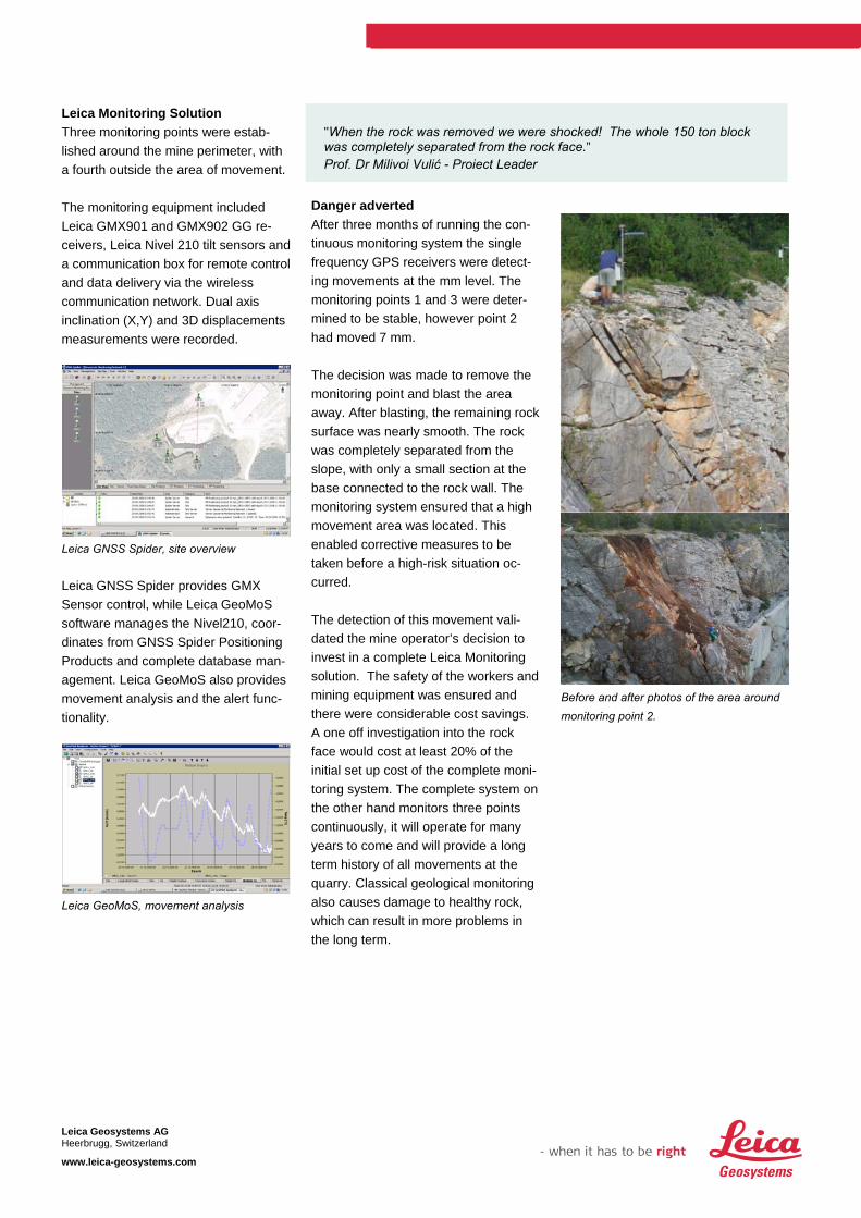
Danger adverted After three months of running the con-tinuous monitoring system the single frequency GPS receivers were detect-ing movements at the mm level. The monitoring points 1 and 3 were deter-mined to be stable, however point 2 had moved 7 mm. The decision was made to remove the monitoring point and blast the area away. After blasting, the remaining rock surface was nearly smooth. The rock was completely separated from the slope, with only a small section at the base connected to the rock wall. The monitoring system ensured that a high movement area was located. This enabled corrective measures to be taken before a high-risk situation oc-curred. The detection of this movement vali-dated the mine operator’s decision to invest in a complete Leica Monitoring solution. The safety of the workers and mining equipment was ensured and there were considerable cost savings. A one off investigation into the rock face would cost at least 20% of the initial set up cost of the complete moni-toring system. The complete system on the other hand monitors three points continuously, it will operate for many years to come and will provide a long term history of all movements at the quarry. Classical geological monitoring also causes damage to healthy rock, which can result in more problems in the long term.
Before and after photos of the area around monitoring point 2.
Leica Geosystems AG Heerbrugg, Switzerland
www.leica-geosystems.com

BSF Swissphoto AG has developeda powerful tool for permanentmonitoring applications calledDeTraS (Deformation TrackingSystem). Sensor control and data-base management is provided byLeica’s GeoMoS Software.
During 2008 and 2009, a 100 year
old bridge close to the Oerlikon
Railway station was renovated. The
old steel construction was replaced by
restressed ferroconcrete and the span
width was increased from 15m to
38m. In order to excavate the existing
bearings, pillars, undercrossings and
rail dam on the eastern side, assistant
bridge elements were constructed.
These temporary bridges lay 80 cm
higher than the old tracks and created
the required space to build the new
bridge.
Torsion is the term used to describe
the twisting of the tracks and it acts
as one of the most critical factors in
rail track geometry. During the first
construction period rail settlement
and the resulting torsion changes
were manually measured each week.
This was labor intensive and resulted
in high costs due to the risk poten-
tial of the construction site.
Due to the compact and fast
installation possibilities of DeTraS,
the entire automatic monitoring
system was set up by 2 people, in
11/2 days and delivering its first
results.
CompanyBSF Swissphoto AG, Zurich
ChallengeRail track, bridge and site monitoring under
dense railway traffic
CustomerSwiss Federal Railways
Date2008-2009
Location
Project SummaryInstruments
Leica TCA2003
Meteo sensor
Leica monitoring prisms
WebCam
Software
Leica GeoMoS Monitor options 1 & 2
BSF Swissphoto’s client portal
Aim
To monitor settlement and torsion of tracks and
3D deformations of pylon and bulkheads
Leica Geosystems TruStoryMonitoring of Rail Tracks andConstruction Site
Reconstruction of the 100 year old railway bridge carrying two railtracks.
Monitoring prisms on the temporary bridge for deformation tracking.
Leica Geosystems AGHeerbrugg, Switzerland
www.leica-geosystems.com
The monitoring equipment included
a Leica TCA2003 total station, meteo
sensor, 55 monitoring prisms and
a communication box for remote
control and data delivery via the
mobile communication network.
Actual deformations of rail geometry
(settlement, torsion, and longitudinal
profile) were based on the positional
change of each monitoring prism.
Site measurements were automati-
cally transmitted to Leica’s GeoMoS
Software located in the office. In the
case that the restrictive limits of the
railway company were exceeded,
SMS and e-mail alarms were sent to
the responsible persons. Possible
problems with the rail alignment
could also be determined and fixed
quickly and efficiently.
In order to monitor the torsion of
the track, inclination values were
computed from the settlement
measurements. Using 2 settlement
measurements at one cross
section results in one inclination
computation. Comparing this
inclination to the next inclination
value along the track you get the
torsion value, indicating the
change along the track axis.
The main advantages of automatic
monitoring compared to manual
monitoring are increased safety,
increased awareness of
deformations, improved efficiency,
and reduced costs. Single point settlement and uplift aftermechanical track alignments on the dam.
Torsions at the different sections showwhen they exceed the two limit classes.
During demolition of parts of the foundation ofthe power line pylon, the monitoring systemwasused to detect 3D deformations and the resultingchange in tilt.
Benefits• Safety, SMS and e-mail alert for
the railway traffic
• Efficiency, BSF Swissphoto client portal for
24h access to real time data
• Analysis, continuous 24h monitoring of
the construction site and the impact on
crucial infrastructure
• Safety, limited staff access to dangerous
construction sites
• Cost reduction, from reduced labor costs
• Efficiency, coordination of rail alignment
actions according to the torsion
calculations
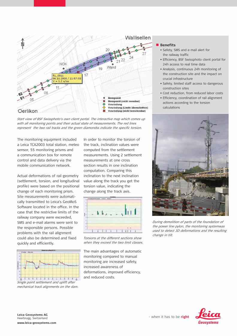
Start view of BSF Swissphoto’s own client portal. The interactive map which comes upwith all monitoring points and their actual state of measurements. The red lines represent the two rail tracks and the green diamondss indicate the specific torsion.

BSF Swissphoto AG has developeda powerful tool for permanentmonitoring applications calledDeTraS (Deformation TrackingSystem). Sensor control and database management is provided by Leica’s GeoMoSSoftware.
During 2007 and 2008 a new
residential house was constructed in
the middle of a built-up area. The
construction project required the
excavation of soil sediment layers as
well as lowering of the surface
groundwater. It was a concern that
these actions might endanger the
surrounding infrastructure and
construction site.
Therefore, a permanent monitoring
system was required to ensure the
safety of surrounding buildings and
construction workers.
Automatic monitoring, operating
24hrs a day was installed to monitor
the adjacent wall. Measurements
were taken twice an hour and
automatic alert triggers were
configured to alert engineers of
exceeded thresholds.
Additional manual leveling,
inclinometer and water gauge
measurements completed the
deformation monitoring in the
nearby area. Webcam images
recorded a history of site
construction and helped to record
a claim of water penetration.
Results and images were accessible
via BSF Swissphoto’s client portal.
Based on the long monitoring period
immediate corrective measures could
be initiated to protect the existing
buildings and construction site
before serious damage occurred.
The effectiveness of the corrective
measures was immediately visible
due to the continuous monitoring.
CompanyBSF Swissphoto AG, Zurich
ChallengeWall monitoring at excavation site
Date2007-2008
Location
Project SummaryInstruments
Leica TCA1101plus
Meteo sensor
Leica monitoring prisms
WebCam
Software
Leica GeoMoS Monitor options 1 & 2
BSF Swissphoto’s client portal
Aim
To predict accelerations of the wall tilt in
order to protect personal and adjacent house
Benefits• Safety of the residents in the bordering
houses and detecting deformations for
taking immediate action
Leica Geosystems TruStoryPermanent Monitoring during Urban Excavation
Leica Geosystems AGHeerbrugg, Switzerland
www.leica-geosystems.com

CompanyKumtor Operating Company, Kyrgyz Republic
ChallengeSlope stability monitoring of an open pit mine
DateInstallation in 2003
Location
Project SummaryInstruments
Leica Leica TCA2003
Leica TCA1201M
Leica Geosystems prisms
Software:
GeoMoS Monitor options 1 and 2
GeoMoS Analyzer
Communications:
Wireless LAN
Aim:
To predict failures in advance in order to
protect personal and equipment
Benefits• Less risk of injury to Kumtor personnel
• Reduced risk to Kumtor property and
equipment
• Higher production due to less down tim
caused by accidents
• Better prediction of failures
Leica Geosystems TruStorySlope Stability Monitoring atKumtor Mine, Kyrgyz Republic
Since 2003 the Kumtor gold minehas been using Leica GeoMoSas their main automaticdeformation monitoring system.Periodic manual monitoring andgeotechnical instrumentation arestill in use for added safety.
Kumtor gold mine is located in the
Tien Shan Mountains at an elevation
of more than 4000 meters. The main
pit’s dimensions are approximately
2000m x 1000m x 600m while the
second pit’s are 1000m x 700m x
400m. The mine extracts about 7600
tons of ore per year and 93000 tons
of waste with a production of about
14 tons of gold.
In addition to the Leica GeoMoS
system monitoring the pits,
several prisms are installed on the
surrounding glaciers and on the
waste dumps for manual
monitoring. Extreme weather
conditions combined with the
dusty environment make it
necessary to do frequent cleaning
of all the prisms.
In July 2006, the duty surveyor
interpreted the warnings sent by
Leica GeoMoS and decided to
evacuate the site. Two hours later
there was a major failure of one
of the pit walls.
Leica Geosystems AGHeerbrugg, Switzerland
www.leica-geosystems.com

Venetia mine are long standingLeica Geosystems customers,having used Leica TC2002 formanual monitoring and thenupgraded to Leica GeoMoS. Themine is situated 80km west ofthe town of Musina in theLimpopo province, far northernSouth Africa, close to the borders of Botswana and
CompanyDe Beers Venetia Mine, Musina, South Africa
ChallengeSlope stability monitoring of an
open pit mine
DateInstallation October 2002
Location
Project SummaryInstruments
Leica TCA2003, Leica prisms
STS meteo sensor
Leica TCA2003 on order
Software
GeoMoS Professional
Communications
PacificCrest PDL radios
PacificCrest PDL radios on order
Aim
To predict failures in advance to protect
personal and equipment from harm
Benefits:• Less risk of injury to Venetia personnel
• Reduced risk to Venetia property and
equipment
• Higher production due to less down time
caused by accidents
• Better prediction of failures
Leica Geosystems TruStorySlope Stability Monitoring atVenetia, South Africa
Zimbabwe. Venetia mine consists of two
major kimberlite pipes and
numerous minor ones, mined
as one pit. Venetia's Pit
dimensions are approximately
1 600m x 1 200m x 200m.
The mine moves about 25million
tons of waste and 5.5million tons
of ore baring material per annum,
producing about 6.5 million carats
per annum.
Temperatures often reach mid
40's in summer with “in-pit”
temperatures soaring above the
50 mark. This creates a lot of
atmospheric interference in the
measurements and thus most
monitoring is done at night.
Leica Geosystems AGHeerbrugg, Switzerland
www.leica-geosystems.com

Straub AG is an engineeringcompany with multiple officesin Switzerland and 40 yearsexperience as experts in engineering surveying projectsworldwide.
For the construction of a new
tunnel through a densely
populated region of Switzerland,
an excavation of a 360m long
section is required. The excavation
is up to 17m deep and is, from a
geotechnical point of view, highly
critical. The protection of the
excavation is done by a wall of
concrete pillars held by rows of tie
bars. Out of concern for the safety
of the residents and the workers
the decision was made to use a
permanent monitoring system to
observe the concrete wall during
over a period of 18 months. As a
supplement they have integrated a
warning system, which will send
CompanyStrago (NA) - San Ruffillo (BO)
ChallengeStraub AG, Ingenieure + Geoinformatiker
5405 Baden-Dättwil, Switzer-land
DateInstallation March 2004
Location
Project SummaryInstruments
Leica TCA1800
Leica Prisms
Software
GeoMoS Professional
GeoMoS Professional Remote
Communications
TCPS26 radios
RS485 cable connection
Autocall Messaging system
Aim
Monitor the excavation and guaranty the
safety for residents and workers.
Benefits:• Safety of the residents and the bordering
houses and detecting deformations on the
concrete wall.
• Facilitate quick reaction for the
construction management
Leica Geosystems TruStoryExcavation Monitoring By-passEnnetbaden
the limit check information via SMS
to the responsible people.
In the event of movement, the
construction management can
react immediately and define steps
for counter measure.
In addition to the total stations,
inclinometers and load cells
monitor the excavation.
Leica Geosystems AGHeerbrugg, Switzerland
www.leica-geosystems.com

In recent years in Italy therehas been growth in large infrastructure projects. One of the most active sectorsis rail, with many works on themodernization of existing railway lines and on the realization of new lines for the High Speed trains.
One of the most crucial inter-
sections is in the town of
Bologna. In the future the Bologna
station will be only connected by
underground rail. Excavation of
the tunnels started in 2003.
The government authority
requires that the construction
companies to monitor in real time
all the civil buildings (houses,
streets, shops etc.) which may be
affected by the excavation.
CompanyStrago (NA) - San Ruffillo (BO)
ChallengeMonitoring of the stability of a drugstore
during excavation with a tunnel boring
machine (TBM)
DateInstallation July 2003
Location
Project SummaryInstruments
Leica TCA1800
Leica prisms
Software
GeoMoS Lite, 1 x System_Anywhere,
Analisys
Communications
3AS Radio-modem Satelline
Aim
To monitor pillars' subsidence during TBM's
excavation
Benefits:To prevent possible subsidences in the
structure of the building due to the lost
of field carrying capacity
Leica Geosystems TruStoryHigh Speed Railway Construction in Bologna, Italy
The San Ruffillo monitoring project
employs 3 Leica TCA1800 (2 exter-
nal and one inside the drugstore)
scheduled to measure the
monitoring prisms every hour, with
the aim of detecting possible
subsidence of the drugstore.
A pool of expert engineers has the
task to analyze data in real time
and to evaluate if there is no
danger for people inside the
drugstore.
Leica Geosystems AGHeerbrugg, Switzerland
www.leica-geosystems.com

INGV is one of the most important Italian scientificauthorities in the study andmonitoring of tectonic and volcanic events. One of itsdepartments studies crustaldeformation analysis in seismic and volcanic areas.
After a submarine landslide
occurred on 28 December 2002
on Stromboli Volcano that caused
a tsunami wave of more than
12 meters in height, the Civil
Protection Department decided to
install on the island several
monitoring systems with the aim
of preventing any kind of risk,
potentially dangerous for people.
CompanyNational Institute of Geophysics and
Vulcanology of Catania (INGV)
ChallengeSlope stability monitoring of an
active volcano
DateInstallation March 2003
Location
Project SummaryInstruments
Leica TCA2003
Leica prisms
Software
GeoMoS Lite, System Anywhere
Analisys
Communications
LAN communications
Aim
To detect land slides in advance to protect
people from the effects of a tsunami
Benefits:• Continuous case of study of the extremely
complex deformation system represented
by the Volcano
• Risk prevention of landslide
Leica Geosystems TruStorySlope Stability Monitoring atStromboli Volcano, Italy
The system, linked in real time
with a Control Room, has been
installed in very prohibitive
conditions (very oxidant atmos-
phere, strong winds, harsh sun
irradiation, continuous exposure
to atmospheric agents, very long
distances, presence of dust due
to rolling stones, dangerous
conditions in target's positioning)
continuously measures targets
positioned in the Sciara del Fuoco
in order to activate alarms.
Leica Geosystems AGHeerbrugg, Switzerland
www.leica-geosystems.com

The Consorzio di Bonifica ofBasso Sulcis is one of thenumerous associations existingin Italy that manages the waterresources. Carbonia's Dam isone of the biggest dams inSardinia and allows water supply for thousands and thousands people.
The Central Government Authority
(Servizio Nazionale Dighe) obliges
such associations to monitor dams
periodically or in real time in order
to prevent eventual problems
related with cracking or failure of
the structures, ageing of materials
with which dams are built and
possible deformations caused by
big hydraulic loads.
The system installed in Carbonia's
dam uses Leica TCA2003 which
measures every four hours a
series of prisms positioned on the
crest and on the face of the dam.
Data from a chain of Nivel 20
installed inside the main under-
ground tunnel are collected every
five minutes with the aim
to detect eventual rotations of
the main body of the dam,
caused by the growing mass of
water in the dam.
CompanyConsorzio di Bonifica del Basso Sulcis
ChallengeDam monitoring
DateInstallation December 2002
Location
Project SummaryInstruments
Leica TCA2003, Leica prisms,
Nivel20
Software
GeoMoS Professional, GeoMoS Remote,
Eyes on nivel
Communications
RS232 with signal amplifiers
Aim
To monitor the three coordinates movements
of the dam
Benefits:• Early detection of possible safety issues
in the dam, acting as a safeguard to
protect lives to personnel.
Leica Geosystems TruStoryDam Monitoring in Carbonia, Italy
Leica Geosystems AGHeerbrugg, Switzerland
www.leica-geosystems.com

During a significant, extremelyviolent meteorological eventthat occurred in Northern Italyon November 2002, many phenomena concerning environmental instability tookplace and caused a lot of landslides in different regionsof the Alps.
One of the most important of
them involved a whole mountain
in Valsassina Valley which, during
a night of intense rainfalls,
collapsed into the main valley
destroying part of a little city
called Bindo and inciting other
instabilities in a secondary valley
leading to four smaller landslides
that threatened the town of
Cortenova in the valley below.
During and after this event the
local population was evacuated
and the local authority decided
to install a complex real time
monitoring system (geodetic and
geotechnical) that is able to
activate on site alarms to alert
local people.
Leica TCA2003 total stations have
been installed to measure every
hour a certain number of prisms
located on the landslide. The data
are collected in a central database
and are analyzed in real time.
A sophisticated alarm system
enables phone calls or GSM
messages be sent to people
whose main task is to manage
the whole system and to care
about the security of local
population. A permanent GPS
control network has also been
installed with the aim to study
the complex system of
deformations located between
the two main landslides. In fact
one of the more important
problems regards the supposition
of an eventual coalescence of the
two landslides that will provocate
a big solid flow with terrible
consequences for the local
population.
CompanyMountain Community of Valsassina and
Valvarrone
ChallengeMonitoring of a complex landslide above
the city of Cortenova
DateInstallation June 2003
Location
Project SummaryInstruments
Leica TCA2003, Leica prisms,
Leica SR520
Software
GeoMoS Lite, System Anywhere,
Analisys, GPS Anywhere, NDA (Network
Deformation Analysis)
Communications
3AS Radio-modem Satelline
Aim
To monitor landslides and to send timely
alarms allow evacuation of the local
Benefits:• Permanent monitoring to assure people
safe life’s condition
• Risk prevention of landslide
Leica Geosystems TruStorySlope Stability Monitoringat Cortenova, Italy
Leica Geosystems AGHeerbrugg, Switzerland
www.leica-geosystems.com

Letlhakane mine is not anexclusive Leica Geosystemsuser and did not have an effective monitoring system in place before implementingLeica GeoMoS.The mine is situated nearLetlhakane, which is 190kmwest of the town ofFrancistown in Botswana andabout 50km south east ofOrapa.
The ore body at Letlhakane mine
consists of one intrusive kimberlite
pipe with no overburden.
Letlhakane's Pit dimensions are
approx 1200m diameter x 260m.
The mine extracts approximately
4m tons of ore per year and 16m
tons of waste with a production
of about 26 carats per 100 tons
of ore. Letlhakane produced
approximately 1.4m carats in
2003.
CompanyDebswana, Letlhakane Mine, Botswana
ChallengeSlope stability monitoring of an open
pit mine
DateInstallation May 2003
Location
Project SummaryInstruments
Leica TCA2003
Leica prisms
STS meteo sensor
Software
GeoMoS Professional
Communications
PacificCrest PDL radios
Aim
To predict failures in advance to protect
personal and equipment from harm
Benefits:• Less risk of injury to Letlhakane personnel
• Reduced risk to Letlhakane property and
equipment
• Higher production due to less down time
caused by accidents
• Better prediction of failures
Leica Geosystems TruStorySlope Stability Monitoring atLetlhakane Mine, Botswana
Temperatures often reach mid to
high 40 deg C in summer with
“in-pit” temperatures reaching the
upper 40's to lower 50's. It is a dry
arid region with very low rainfall
thus heat and dust are limiting
factors for the monitoring of the
slopes.
Leica Geosystems AGHeerbrugg, Switzerland
www.leica-geosystems.com

GDTest is one of the numerousengineering societies placed in Italy with which LeicaGeosystems is co-operatingmore and more in the installa-tion of real time monitoringsystems. In 2003 we havejointly installed a completemonitoring system in the railway station of LimonePiemonte.
The mountain side just above the
railway station is the subject of a
slow landslide. During strong
meteorological events this part of
the mountain slides down towards
valley, endangering the safety of
the below railway station and
tracks.
CompanyGDTest (Turin) - RFI (Turin)
ChallengeMonitoring of a slow landslide above a
railway station
DateInstallation February 2003
Location
Project SummaryInstruments
Leica TCA2003
Leica prisms
Software
GeoMoS Lite
System_Anywhere
Analisys
Communications
RS232
Aim
To monitor the slow deformation process of
a part of a hill just above a railway station
Benefits:The system enables the railway station
to be operated safely in an area subject
to land slides
Leica Geosystems TruStorySlope Stability Monitoring at Limone Piemonte, Italy
The system installed in Limone
Piemonte is based around Leica
TCA2003 which measures a series
of prisms positioned all over the
hill every four hours. The data are
stored in the Leica GeoMoS
database are analyzed just after
the cycle and if limit classes are
exceeded an alarm system (phone
and GSM message) is automatically
activated to alert people and to
prevent possible railway disasters.
Leica Geosystems AGHeerbrugg, Switzerland
www.leica-geosystems.com

Phase 2 of the £3.3Bn ChannelTunnel Rail Link program incorporates extensive tunneling under existing infrastructure in London.Nuttall, Wayss, Freytag andKier JV who are the main con-tractor on CTRL250 subcon-tracted Mabey SupportSystems and Test Consult tomonitor an area nearDagenham and Barking in EastLondon.
This particular project focused
upon the impact of two 7.2m
diameter tunnels that were to be
bored under a section of rail, and
under an associated bridge and
ramp down to a major freight ter-
minus. A predicted 60mm to
65mm of movement was to be
measured and fed back to a
control system operating hydraulic
jacks. As a result of any detected
movement the pressure in the
jacks was to be increased
automatically to maintain the
height of the bridge and ramp.
GeoMoS was installed to operate
the Leica TCA2003 instruments
and to provide the detected
movement from each prism.
An SQL query was generated
every five minutes, twenty-four
hours a day for a period of 5
months to generate the required
information for the jacking system.
SMS messaging was used to
inform the operators of any
excessive movement and data
was published to a website for
general viewing.
CompanyNuttall, Wayss, Freytag and Kier Joint
Venture - CTRL Contract 250
ChallengeBridge and Road Monitoring during
Tunnel Construction
DateInstallation January 2003
Location
Project SummaryInstruments
Leica TCA2003,
Leica prisms,
Software
GeoMoS Professional
Communications
TCPS26B Radio Modems
Aim
To monitor a bridge and section of road
during tunnelling activities. System produced
height displacement values to allow hydraulic
jacks to correct for movements.
Benefits:• 24 Hour monitoring and feedback to
corrective jacks.
• Automated Messaging
• Area to be monitored was in an active
railway zone - no personnel permitted
without special permits, look outs etc.
Leica Geosystems TruStoryBridge Jacking, CTRL250, East London, UK
Leica Geosystems AGHeerbrugg, Switzerland
www.leica-geosystems.com

KCRC has commenced the construction of Lok Ma ChauSpur Line to ease the congestion at Lo Wu Terminus.Sheung Shui station is an intersection for these two terminuses. It handles about 180,000 passengers a day. In June 2003,an improvement project forSheung Shui Station has beenstarted. It includes the extension of station concourse, widening of the platform and construction of a new entrance. These construction works maycause the movement of theexisting railway in Sheung ShuiStation. In order to minimizethe risk caused by the movement of the railway, theCustomer has decided to setup an ADMS to monitor the railway.
CompanySurtech Engineering Surveys
ChallengeMonitor and display the movement of the
railway in real time
Date2003 - 2006
Location
Project SummaryInstruments
Leica TCA2003
Prisms
Software
GeoMoS Professional
Communications
PacificCrest PDL radios
Aim
Line Driver
Internet Broad Band
Benefits:• Automatic & continuous monitoring of the
railway in real time
• All related parties can share the measuring
result through customer's Web Site
• Initial alarm system to reduce risk
Leica Geosystems TruStoryRailway Monitoring at Sheung Shui Station, Hong Kong
Leica GeoMos with Leica TCA2003
can achieve the accuracy of 1mm
in 100m. All points are measured
and stored in SQL database. A web
interface is used to provide a real
time data report. Any movement
which exceeds the predefined
limits will activate the alarm
system. SMS and email will be sent
out. Those moving points will be
highlighted in the data report too.
Leica Geosystems AGHeerbrugg, Switzerland
www.leica-geosystems.com

PPL are long standing LeicaGeosystems customers, havingused TC2002 for manual monitoring and then upgradedto Leica GeoMoS. The mine issituated near the town ofMokopane (formerly known asPotgietersrust) in the Limpopoprovince, Northern SouthAfrica.
PPL mine consists of two open
pits called Sandsloot and
Zwartfontein. Sandsloot mine is
approximately 2km in length,
600m wide and over 200m deep.
Zwartfontein is a new pit, which
has been in operation for less
than 2 years. About 150 000 tons
of material is extracted each day
of which more than 20 000 tons
makes up the platinum group
metals.
CompanyAnglo Platinum, Potgietersrust, South Africa
ChallengeSlope stability monitoring of an open
pit mine
DateInstallation October 2003
Location
Project SummaryInstruments
Leica TCA2003
Leica prisms
Software
GeoMoS Professional
Communications
PacificCrest PDL base radios
Aim
To predict failures in advance to protect
personal and equipment from harm
Benefits:• Less risk of injury to PPL personnel
• Reduced risk to PPL property and
equipment
• Higher production due to less down time
caused by accidents
• Better prediction of failures
Leica Geosystems TruStorySlope Stability Monitoring at PPL Mine, South Africa
The mine gets about 330mm of
rain per year and summer
temperatures often reach the low
40 degrees. This, coupled with
fairly dusty conditions makes
visibility and therefore monitoring
very difficult.
Leica Geosystems AGHeerbrugg, Switzerland
www.leica-geosystems.com

Zermatt is one of Switzerland'smost popular ski resorts. TheFurggsattel glacier chair lifttransports a maximum of 2400 persons per hour duringsummer and winter.
Furggsattel, which is at an altitude
of 3365m, is the longest chair lift
in Europe with a length of 2600m.
The chair lift is built on a glacier
that is constantly moving. To
compensate for the movement of
the glacier, the pylons of the chair
lift must be regularly adjusted.
The supports on the ice are
designed so that they can be
displaced by 75 cm on their steel
foundations.
There are two prisms mounted on
each of the 12 supports. On the
top station building there is a
reference point that is used to
adjust the orientation of the
CompanyZermatt Bergbahnen, CH-3920 Zermatt
ChallengeMonitoring of the pylons of a glacier
chair lift
DateInstallation February 2004
Location
Project SummaryInstruments
Leica TCRA1103
Leica prisms
Software
GeoMoS Professional
Communications
Radios Sateline 3Asd (Distance 1200m)
Aim
To monitor the position of the ski lift
supports so that they may be adjusted to
compensate for movement of the glacier
Benefits:• Makes maintenance for the geometry of
the ski lift more effective.
Leica Geosystems TruStorySki Lift Monitoring in Zermatt,Switzerland
system. An Excel Macro is used to
analyze the displacement of all
supports in plane, height and
rotation. All the equipment is
powered by one solar panel. All
points are measured in the ATR
mode for highest accuracy, with
the furthest point at a distance of
about 1200m. In the near future,
a new window will be installed
with integrated heating to
eliminate ice and snow on the
glass.
Leica Geosystems AGHeerbrugg, Switzerland
www.leica-geosystems.com

Jwaneng mine is not an exclusive Leica Geosystemsuser and did not have an effective monitoring system inplace before implementingLeica GeoMoS. The mine is situated near Jwaneng, which is 170km west of the capital ofBotswana, Gaborone.
The ore body at Jwaneng mine
consists of three kimberlite pipes
with no overburden. Jwaneng's Pit
dimensions are approx 1500m x
1000 x 260m. The mine extracts
approximately 10m tons of ore per
year and 40m tons of waste with
a production of about 125 carats
per 100 tons of ore, which makes
it the richest diamond mine in the
world. Jwaneng produced more
than 14m carats in 2003.
CompanyDebswana, Jwaneng Mine, Botswana
ChallengeSlope stability monitoring of an
open pit mine
DateInstallation May 2004
Location
Project SummaryInstruments
Leica TCA2003
Leica prisms
STS meteo sensor
Leica TCA2003 on order
Leica prisms on order
Software
GeoMoS Professional
Communications
PacificCrest PDL radios
PacificCrest radios on order
Aim
To predict failures in advance to protect
personal and equipment from harm
Benefits:• Less risk of injury to Jwaneng personnel
• Reduced risk to Jwaneng property and
equipment
• Higher production due to less down time
caused by accidents
• Better prediction of failures
Leica Geosystems TruStorySlope Stability Monitoring atJwaneng, Botswana
Temperatures often reach mid to
high 40 deg C in summer with
“in-pit” temperatures reaching the
upper 40's to lower 50's. It is a
dry arid region with very low
rainfall thus heat and dust are
limiting factors for the monitoring
of the slopes. As with Orapa,
long distances are also a limiting
factor to the ATR.
Leica Geosystems AGHeerbrugg, Switzerland
www.leica-geosystems.com

Navachab mine is not an exclusive
Leica Geosystems user but have been
using a Leica TCA2003 Total Station
to monitor the slopes manually
before deciding to implement Leica
GeoMoS, after a two week trial
period and a recommendation by SRK
to implement Leica GeoMoS.
The mine is situated near Karibib,
which is approximately 170km North
West of Windhoek in Namibia and
about 170km North East of the
coastal town of Swakopmund.
The Gold at Navachab mine is
hosted in marble and the host
rock dips at 70 degrees to the
west. Grades at Navachab are
approxi-mately 2 grams/ton. Pit
dimensions are approx 1300m x
800m x 200m.
Temperatures often reach low to
mid 40 deg C in summer with
“in-pit” temperatures reaching
the upper 40's. It is a dry arid
region with very low rainfall thus
heat and dust are limiting factors
for the monitoring of the slopes.
TaskSlope Stability Monitoring of an
open pit mine
CustomerAnglogold-Ashanti, Navachab Gold Mine,
Karibib, Namibia
Location21° 59’ S. 15° 46’ E
DateInstallation April 2005
Project FactsSoftware GeoMoS professional
Instruments Leica TCA2003
Leica prisms
STS meteo sensor
Communications Pacific Crest EDLII radios
Aim To predict failures in advance in a special
deepening project at the mine in order
to protect personal and equipment
from harm
Benefits:• Reduced risk of injury to Navachab personnel
• Reduced risk to Navachab property and
equipment
• Higher production due to less down time
caused by accidents
• Better prediction of failures
Leica Geosystems TrustorySlope Stability Monitoring at Navachab, Namibia
Leica Geosystems AGHeerbrugg, Switzerland
www.leica-geosystems.com
EDL radio modemPrevious slope failure
Leica TCA2003

In 2002, Edmund Nuttall wonthe contract to improve theinterchange of the M1 motorway and the A43 trunkroad at junction 15a inNorthamptonshire. The primaryelement of the project comprised a boxjack throughthe current motorway embankment, in order toupgrade the existing A43, running beneath the M1, to dual-carriageway status.
The Highways Authority would
allow no closure of this arterial
route and imposed maximum
allowable carriageway heave and
settlement contour limits
throughout the jacking period.
In addition, they required
observational verification of
the results in real time.
ITM proposed an innovative
solution, using Leica TCRA1105
Total Stations operating in
reflectorless mode. Each
instrument was installed on a
column 15m above the
carriageway, cycling automatically,
CompanyEdmund Nuttall / Highways Agency / ITM Ltd
ChallengeMonitor a live motorway while a box jack
was installed
DateInstallation January 2003
Location
Project SummaryInstruments
Leica TCRA1105
Leica prisms
Software
GeoMoS Lite
Communications
TCPS26B Radio Modems
Aim
To monitor the carriageway surface of the
M1 during the installation of a box jack.
Benefits:• 24 Hour monitoring and feedback.
• Automated Messaging
• Monitoring had to be non-intrusive as the
motorway was to be kept open and
operational at all times.
Leica Geosystems TruStoryMotorway Surface Monitoring,Northamptonshire, UK
every 30 minutes, through a 1-2m
grid of virtual points coordinated
three-dimensionally across both
carriageways throughout the whole
zone of influence.
Data was transmitted via radio
modem where it was displayed in
real time using ITM's own software.
This gave both the engineers on
site and staff at the ITM head
office, via a remote link, immediate
access to up-to-date, real-time
data. All the data could be viewed
remotely, 24 hours a day, through
a secure, real-time web site, and
an automated "ALERT" program
contacted nominated personnel
should any predetermined trigger
levels be exceeded outside normal
working hours. Thus, in the event
of an alert, an action plan could be
initiated by authorised personnel
at any time, without the need to
attend either site or office. As a
result of this monitoring regime,
all six lanes of the motorway at
this bottleneck junction remained
operational throughout the
six-month monitoring period.

Orapa mine are long standingLeica Geosystems customers,having used Leica TCA2003 for manual monitoring and thenupgraded to Leica GeoMoS.The mine is situated nearOrapa, which is 240km west ofthe town of Francistown inBotswana.
The ore body at Orapa mine con-
sists of two intrusive kimberlite
pipes with no overburden. Orapa's
Pit dimensions are approx.
1500m x 1000m x 240m. The
mine extracts approximately 20m
tons of ore per year and 40m
tons of waste with a production
of about 85 carats per 100 tons
of ore. Orapa achieved record
production in 2003 of
approximately 30m carats.
CompanyDebswana, Orapa Mine, Botswana
ChallengeSlope stability monitoring of an open
pit mine
DateInstallation April 2004
Location
Project SummaryInstruments
Leica TCA2003
Leica prisms
STS meteo sensor
Software
GeoMoS Professional
Communications
PacificCrest PDL radios
Aim
To predict failures in advance to protect
personal and equipment from harm
Benefits:• Less risk of injury to Orapa personnel
• Reduced risk to Orapa property and
equipment
• Higher production due to less down time
caused by accidents
• Better prediction of failures
Leica Geosystems TruStorySlope Stability Monitoring at Orapa Mine, Botswana
Temperatures often reach mid to
high 40 deg C in summer with
“in-pit” temperatures reaching the
upper 40's to lower 50's. It is a
dry arid region with very low
rainfall thus heat and dust are
limiting factors for the monitoring
of the slopes. A compounding
factor is the long distances,
which have to be measured to
some of the monitoring points.
Distances in some cases are as
much as 1400m, which make it
extremely difficult for the ATR
to find some points. These
points are generally monitored
during the night.
Leica Geosystems AGHeerbrugg, Switzerland
www.leica-geosystems.com

Nuttall, Wayss, Freytag andKier JV, main contractor for theChannel Tunnel Rail LinkContract 250, had to giveassurances to Network Rail andLondon Underground Ltd thattheir tunnelling activities wouldnot jeopardise the existing railinfrastucture. This was particularly important throughthe strategic rail complex atBarking, which is in operation24 hours a day. A number ofdifferent methodologies wereconsidered, but following thesuccess of the Bridge Jackingexercise, at Renwick Road,using Leica GeoMoS and LeicaTCA2003s, they decided toemploy similar techniques forthe last 1.4km of the TBMdrive.
A rolling program of instrument
installations on pillars running
alongside the existing surface rail-
ways was employed in order to
establish base readings prior to
the passing of the Tunnel Boring
Machines underneath. Two
Leica GeoMoS installations
were operated controlling, an
assortment of motorised Total
Stations with Auto Target
Recognition. Communications
were provided by both TCPS26
and Pacific Crest PDL modems,
the latter being used where
increased range was required.
SQL query statements were used
to extract data from the GeoMoS
database and a series of macros
within MicroSoft Excel were used
to display trends graphically for
analysis.
CompanyNuttall, Wayss, Freytag and Kier Joint
Venture - CTRL Contract 250
ChallengeMonitor a live rail complex during tunnel
construction
DateInstallation November 2003
Location
Project SummaryInstruments
Leica TPS1000, TPS1100 and TPS2000
Leica prisms
Software
GeoMoS Professional Multiple Sensors
Communications
TCPS26B + Pacific Crest
PDL Radio Modems
Aim
To monitor the Barking railway complex, a
strategic railway junction in East London,
which is used by London Underground
Limited (LUL) and Network Rail (NR)
24hrs/day
Benefits:• 24 Hour monitoring and feedback to TBM
operators and interested parties.
• Automated Messaging.
• Area to be monitored was in an active
railway zone - no personnel permitted
without special permits, look outs etc.
Leica Geosystems TruStoryRail Monitoring, CTRL250, East London, UK
Leica Geosystems AGHeerbrugg, Switzerland
www.leica-geosystems.com

Kalgold mine are long standingLeica Geosystems customers,having used Leica TC1800 formanual monitoring and thenupgraded to Leica GeoMoS.The mine is situated 80kmsouth west of the town ofMafikeng in the North Westprovince, far northern SouthAfrica, close to the border ofBotswana.
Kalgold mine consists of an almost
vertical ore body with an average
width of 45m and an average
grade of 1.5g per ton. Kalgold's
Pit dimensions are approximately
1200m x 800m x 240m. The mine
produces approximately 250kg of
gold per month from a low grade
ore body. Costs are kept to a
minimum by increasing the angle
of the pit slopes, up to 78deg
and a 100m deepening cut with
vertical slopes. This makes
monitoring a critical part of the
operation.
CompanyHarmony, Kalgold, Mafikeng South Africa
ChallengeSlope stability monitoring of an open
pit mine
DateInstallation August 2002
Location
Project SummaryInstruments
Leica TCA2003
Leica prisms
STS meteo sensor
Software
GeoMoS Professional
Communications
PacificCrest PDL radios
PacificCrest PDL radio repeater
Aim
To predict failures in advance to protect
personal and equipment from harm
Benefits:• Less risk of injury to Kalgold personnel
• Reduced risk to Kalgold property and
equipment
• Higher production due to less down time
caused by accidents
• Better prediction of failures
Leica Geosystems TruStorySlope Stability Monitoring at Kalgold Mine, South Africa
Temperatures often reach low to
mid 40 deg C in summer with
“in-pit” temperatures reaching
the upper 40's. Summer rain
storms create an extra hazard
with slip planes being lubricated
by water ingress into cracks
behind the pit faces.
Leica Geosystems AGHeerbrugg, Switzerland
www.leica-geosystems.com

In January 2003 there was afall of approximately 150 m3 ofrock from above the Chüebalmtunnel in Iseltwald/Interlaken.The falling rock punctured thetunnel near the westernentrance and blocked the highway.
After this event two instable rock
masses were blasted to help pre-
vent a recurrence of the rock fall.
In addition the tunnel roof was
repaired and reinforced and a
protective dam was constructed
above the exposed village.
During the reconstruction work
two monitoring systems (Leica
GeoMoS and a geotechincal
system) were used to measure
the movements of the rock face.
The monitoring systems were used
to ensure the safety of the
motorists on the highway and the
construction workers. If a toler-
ance is exceeded or a system error
occurred, warnings were sent to
CompanyDepartment of Transportation, Canton Bern
ChallengeMonitoring of a rock wall after a rock fall
in order to protect works for rebuilding and
traffic
DateOperated: January 2003 - November 2003
Location
Project SummaryInstruments
Leica TDA5005
Leica prisms
Software
GeoMoS Professional
Communications
Fixed phone line for remote access
Mobile phone for SMS messaging
Aim
Early warning of rock falls.
Benefits:• Ensure safety of the motorists and
workers.
• Monitoring of the dangerous section of
the rock face.
Leica Geosystems TruStoryRock Stability Monitoring inInterlaken, Switzerland
the responsible authorities via
SMS. After all of the rebuilding
works were put in place the
automatic monitoring system was
deinstalled. Currently the rock
face is monitored periodically
with manual measurements.
Leica Geosystems AGHeerbrugg, Switzerland
www.leica-geosystems.com

The Gotthard base tunnel willbe the longest rail tunnel inthe world upon its completion.There is a small risk that con-struction of the tunnel willcause movements in the landabove because of water beingdrained from the rock mass.Above the area of the tunnelare three of the largest damsin Switzerland.
The awarding authority, "AlpTransit
Gotthard AG", decided that it is
necessary to continuously monitor
the dams and the nearby valleys
and mountain peaks. Realization
of the monitoring system has
been complicated by the altitude
(~2000m), harsh winter conditions
and remoteness of the site. The
system uses solar power and data
communication via GSM phone to
power and communicate with the
sensors.
The monitoring system has been
running successfully all year round
for several years and produces
millimeter accurate measurements
of the movements.
CompanySwissphoto Group AG, Regensdorf (CH)
ChallengeMonitoring of land forms in the area of
three major dams during the construction
of the 57km long Gotthard base tunnel
under the Swiss Alps.
DateInstallation June 2000-2015
Location
Project SummaryInstruments
Leica TCA2003
Meteo sensor
Leica GPR121 PRO prisms
Software
GeoMoS Professional
Communications
Satelline 3AS Radio Modems
Benefits:• Less risk that the tunnelling is
interrupted
• Minimise the risk that the dams are
damaged by movements in the terrain
caused by the tunnelling
Leica Geosystems TruStoryMonitoring Land Forms in the Swiss Alps
Leica Geosystems AGHeerbrugg, Switzerland
www.leica-geosystems.com

The tunnels of the M-111 road, to its passage under the runway of Madrid - Barajas airport, must be monitored for deformation of the pre-fabricated structure. The monitoring is necessarybecause of the weight of 20meters of ground and othermaterials that must be supported, in addition to thetransit of airplanes.
Both external tunnels are being
monitored in order to control the
4 tunnels structures. There are
four Leica TCA2003 in each tunnel
measuring in one hour cycles,
24 hours per day. There are seven
targets (mining prisms) placed in
each section of the tunnel that
should be monitored. In total
there are more than 20 sections
in each tunnel for which
CompanyOHL - Indra Sistemas.
ChallengeControl of convergences in the tunnels of
the M-111 highway, Barajas-Madrid airport.
DateInstallation May 2003
Location
Project SummaryInstruments
Leica TCA2003
GPR112 Monitoring-Mining Prisms
Software
GeoMoS Professional. Option 2
(>3 sensors)
Communications
Ethernet Converters with two COM ports
Hubs
Control Center connection via intranet with
optical fiber. Controlled remote about of 4 km
Aim
In order to control the deformations and
detect low range movements.
Benefits:• Less time and money for control of
deformations in order to guarantee the
security.
• It avoids the use of more complex
technology and more expensive equipment
to obtain the same final results.
• Automatic system that avoids made
dispersed and less precise manual
measurment.
Leica Geosystems TruStoryControl of convergences in M-111 tunnels, Spain
convergences must be measured
with millimeter accuracy. This
means that there are about 300
positions monitored continuously
with the highest accuracy and
reliability.
The communications between the
Leica TCA2003 and the PC running
Leica GeoMoS, located in the
control and security center of the
tunnels, is established via IP
address from 4 km away.
The control of the system can be
made remotely from anywhere
with access to the Internet.
Leica Geosystems AGHeerbrugg, Switzerland
www.leica-geosystems.com

In den drei großen Tagebau-betrieben Hambach, Garzweilerund Inden der RWE Power AGwerden jährlich rd. 100 Mio tBraunkohle gefördert. DerHauptanteil der Braunkohlen-förderung wird zurStromversorgung eingesetzt.
Insgesamt werden jährlich rd. 77
Mrd KWh (entspricht 15 % des
deutschen Stromverbrauchs)
erzeugt. Mit einer Förderleistung
von rd. 40 Mio t Braunkohle - dies
entspricht etwa einem Anteil von
20 % der gesamtdeutschen
Braunkohlenjahresproduktion - ist
der Tagebau Hambach einer der
leistungsfähigsten Braunkohlen-
tagebaue der BRD.
Die durchgeführten Messungen
geben Aufschluss über die
Bewegung der Böschungsober-
fläche. Am zeitlichen Verlauf der
Messwerte kann in einem Weg-
Zeit-Diagramm erkannt werden, ob
es sich bei den gemessenen
KundeRWE Power (Tagebau Hambach),
Bundesrepublik Deutschland
AufgabeAutomatisches Messsystem zum Messen
von Böschungsoberflächen
DatumInstallation 2002
Ort
ProjektfaktenInstruments
Leica TM1100 plus DI3000S
Leica prisms
GPS
DTM Meteo Sensor
Software
GeoMoS Professional
GeoMoS Server
GeoMoS Analyzer
GeoMoS Remote
Kommunikation
Satelline 2AS Funkgeräte
Datenkabel, Länge >1 km
Nutzen
Erkennen von Entlastungsverformungen
Vorteile• Kontrolle der Böschungsverformungen
• Information über die Messwerte in
Weg-Zeit-Diagrammen
Leica Geosystems TruStoryMessung von Böschungsober-flächen, Deutschland
Bewegungen um normale Entlas-
tungsverformungen oder möglicher-
weise beginnende Bruchverform-
ungen handelt. Bruchverformungen
gefährden die Standsicherheit von
Böschungen und erfordern
angepasste Sicherungsmaßnahmen.
Die Beobachtung bzw. Kontrolle
von Böschungsverformungen sind
ein unverzichtbarer Teil der
Standsicherheitsbeurteilung von
großen Tagebaurandböschungen
und sind daher wichtige
Komponenten einer modernen
Tagebautechnologie.
Leica Geosystems AGHeerbrugg, Switzerland
www.leica-geosystems.com

Für die Überwindung eines tiefenTaleinschnitts auf der AutobahnA2 im Packabschnitt* wurde eineBogenbrücke geplant. Die dafür notwendigeHolzhilfskonstruktion wurdewährend des Betonierens permanent überwacht um dieMenge des eingebrachten Betons regeln zu können.
Betoniert wurde in Abschnitten,
wobei am Rand des Bogens
begonnen wurde. Durch die Last
des Betons ergaben sich dort die
größten Bewegungen. Sowohl
vertikal als auch horizontal
(in Richtung der Brücke) wurden
an diesen Stellen Bewegungen bis
zu 18cm beobachtet.
KundeDipl.Ing. Chritian MALETZ
Ingenieurkonsulent für Vermessungswesen
(Villach)
AufgabeÜberwachung der Hilfskonstruktion einer
Bogenbrücke während der Bauphase.
DatumTemporärer Aufbau im Winter 2002/03
Ort
ProjektfaktenInstrumente
Leica TCA1800
Miniprismen
Software
GeoMoS Professional
Kommunikation
Telefonleitungen mit Modem vor Ort
Nutzen
Beschleunigung des Baufortschritts
Leica Geosystems TruStoryBauwerksüberwachung A2Südautobahn, Österreich
Die Steuerung des Systems erfolgte
über Fernwartung von Villach aus.
Excel-Tabellen mit den Bewegungen
der beobachteten Punkte wurden
automatisch als E-Mails an alle
Verantwortlichen geschickt.
Leica Geosystems AGHeerbrugg, Switzerland
www.leica-geosystems.com
* (Steiermark, Österreich

Auf Grund des speziellen geolo-gischen Aufbaus (Illschotter überwasserlöslicher Schicht) bestehtim Bereich der Speicherseenbeim Kraftwerk RODUND Gefahrdes plötzlichen Einbruchs derErdoberfläche.
Durch solche Ereignisse können zwei
Häuser und die Dämme der Seen
gefährdet werden. Da die Erdfälle,
wie diese Einbrüche genannt wer-
den, mit Geschwindigkeiten von bis
zu einigen Metern pro Stunde erfol-
gen können, ist eine permanente
Beobachtung aller Punkte not-
wendig, um im Ernstfall rasch
reagieren zu können.
KundeVorarlberger Illwerke AG, Schruns (A)
AufgabeÜberwachung von Dämmen dreier
Pumpspeicherseen der Werke RODUND.
(Vorarlberg)
Datumpermanent
Ort
ProjektfaktenInstrumente
Leica TCA1800
Leica Rundprismen
Software
GeoMoS Professional
Kommunikation
fixe Datenleitungen
Nutzen
• Risikominimierung von Personen- und
Sachschäden
• Erfüllung amtlicher Auflagen
Leica Geosystems TruStoryErdfallüberwachungRODUND Austria
Die Daten werden an eine Zentrale
weitergeleitet wo sie ausgewertet
und analysiert werden. Sollten
Toleranzwerte überschritten werden,
setzen Warneinrichtungen
Meldungen an verantwortliche
Personen ab.
Leica Geosystems AGHeerbrugg, Switzerland
www.leica-geosystems.com

Leica Geosystems AGHeerbrugg, Switzerland
www.leica-geosystems.com
Whether you monitor the movement of a volcanic slope, the structure of a
long bridge or track the settlement of a dam; whether you measure, analyse
and manage the structures of natural or man-made objects: the monitoring
systems by Leica Geosystems provide you with the right solution for every
application.
Our solutions provide reliable, precise data acquisition, advanced
processing, sophisticated analysis and secure data transmission. Using
standard interfaces, open architectures and scaleable platforms, the
solutions are customizable to meet individual requirements - for permanent
and temporary installations, for single sites and monitoring networks.
When it has to be right.


