Download - MANAGEMENT PLAN 2011 - 2016

1
ELVETHAM HEATH
LOCAL NATURE RESERVE
& OPEN SPACES
MANAGEMENT PLAN 2011 - 2016

2
Site Name – Elvetham Heath LNR & Open Spaces
Location – Fleet, North Hampshire
Head of Service – Carl Westby
Departmental Manager – Adam Green
Site Ranger – Duke Banfield
Plan prepared by – Timothy Ackroyd
Plan updated by – Duke Banfield
Plan edited by – Steven Lyons
Date of draft – April 2011
Date of final copy – January 2012
Review date – Annual Long term review 2015
3
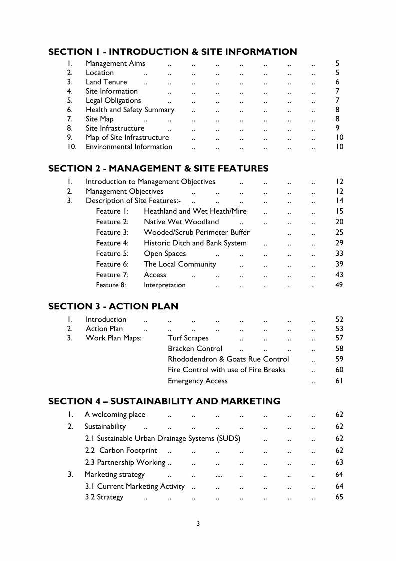
SECTION 1 - INTRODUCTION & SITE INFORMATION
1. Management Aims .. .. .. .. .. .. .. 5
2. Location .. .. .. .. .. .. .. .. 5
3. Land Tenure .. .. .. .. .. .. .. .. 6
4. Site Information .. .. .. .. .. .. .. 7
5. Legal Obligations .. .. .. .. .. .. .. 7
6. Health and Safety Summary .. .. .. .. .. .. 8
7. Site Map .. .. .. .. .. .. .. .. 8
8. Site Infrastructure .. .. .. .. .. .. .. 9
9. Map of Site Infrastructure .. .. .. .. .. .. 10
10. Environmental Information .. .. .. .. .. .. 10
SECTION 2 - MANAGEMENT & SITE FEATURES
1. Introduction to Management Objectives .. .. .. .. 12
2. Management Objectives .. .. .. .. .. .. 12
3. Description of Site Features:- .. .. .. .. .. .. 14
Feature 1: Heathland and Wet Heath/Mire .. .. .. 15
Feature 2: Native Wet Woodland .. .. .. .. 20
Feature 3: Wooded/Scrub Perimeter Buffer .. .. 25
Feature 4: Historic Ditch and Bank System .. .. .. 29
Feature 5: Open Spaces .. .. .. .. .. 33
Feature 6: The Local Community .. .. .. .. 39
Feature 7: Access .. .. .. .. .. .. 43
Feature 8: Interpretation .. .. .. .. .. 49
SECTION 3 - ACTION PLAN
1. Introduction .. .. .. .. .. .. .. .. 52
2. Action Plan .. .. .. .. .. .. .. .. 53
3. Work Plan Maps: Turf Scrapes .. .. .. .. 57
Bracken Control .. .. .. .. 58
Rhododendron & Goats Rue Control .. 59
Fire Control with use of Fire Breaks .. 60
Emergency Access .. 61
SECTION 4 – SUSTAINABILITY AND MARKETING
1. A welcoming place .. .. .. .. .. .. .. 62
2. Sustainability .. .. .. .. .. .. .. .. 62
2.1 Sustainable Urban Drainage Systems (SUDS) .. .. .. 62
2.2 Carbon Footprint .. .. .. .. .. .. .. 62
2.3 Partnership Working .. .. .. .. .. .. .. 63
3. Marketing strategy .. .. .... .. .. .. .. 64
3.1 Current Marketing Activity .. .. .. .. .. .. 64
3.2 Strategy .. .. .. .. .. .. .. .. 65

4
3.3 Corporate volunteers .. .. .. .. .. .. 65
3.4 Special interest group volunteers .. .. .. .. .. 66
3.5 Elvetham Heath profile .. .. .. .. .. .. 66
3.6 Market research programme .. .. .. .. .. .. 66
3.7 Booking system .. .. .. .. .. .. .. 67
3.8 Resources .. .. .. .. .. .. .. .. 67
3.9 Control .. .. .. .. .. .. .. .. 67
SECTION 5 - BIBLIOGRAPHY .. .. .. .. .. .. 69
SECTION 6 - APPENDICES
Appendix 1: Species Lists .. .. .. .. .. 70
Rare and Notable Habitats and Plants .. .. 70
Rare and Notable Invertebrates .. .. .. 71
Appendix 2: Summary of Questionnaire Results .. .. .. 73
Appendix 3: Financial Summary .. .. .. .. .. 74
LIST OF MAPS
Map 1 – Site map Elvetham Heath Nature Reserve .. .. .. .. .. 8
Map 2 – Site infrastructure .. .. .. .. .. .. .. .. 10
Map 3 – Extent of heathland and wet heath/mire community .. .. .. 15
Map 4 – Extent of native wet woodland .. .. .. .. .. .. 20
Map 5 – Extent of wooded/scrub perimeter buffer .. .. .. .. .. 25
Map 6 – Extent of historic ditch and bank system .. .. .. .. .. 29
Map 7 – Extent of open spaces .. .. .. .. .. .. .. 33
Map 8 – Turf scrapes .. .. .. .. .. .. .. .. .. 57
Map 9 – Bracken control .. .. .. .. .. .. .. .. 58
Map 10 – Rhododendron and Goats Rue control .. .. .. .. .. 59
Map 11 – Fire control with use of fire breaks .. .. .. .. .. 60
Map 12 – Emergency Access .. .. .. .. .. .. .. .. 61
5
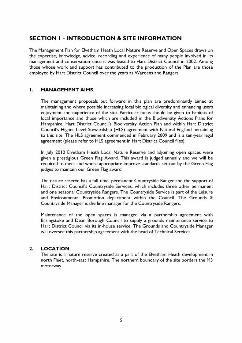
SECTION 1 - INTRODUCTION & SITE INFORMATION
The Management Plan for Elvetham Heath Local Nature Reserve and Open Spaces draws on
the expertise, knowledge, advice, recording and experience of many people involved in its management and conservation since it was leased to Hart District Council in 2002. Among
those whose work and support has contributed to the production of the Plan are those
employed by Hart District Council over the years as Wardens and Rangers.
1. MANAGEMENT AIMS
The management proposals put forward in this plan are predominantly aimed at
maintaining and where possible increasing local biological diversity and enhancing users
enjoyment and experience of the site. Particular focus should be given to habitats of
local importance and those which are included in the Biodiversity Actions Plans for
Hampshire, Hart District Council‟s Biodiversity Action Plan and within Hart District
Council‟s Higher Level Stewardship (HLS) agreement with Natural England pertaining
to this site. The HLS agreement commenced in February 2009 and is a ten-year legal
agreement (please refer to HLS agreement in Hart District Council files).
In July 2010 Elvetham Heath Local Nature Reserve and adjoining open spaces were
given a prestigious Green Flag Award. This award is judged annually and we will be
required to meet and where appropriate improve standards set out by the Green Flag
judges to maintain our Green Flag award.
The nature reserve has a full time, permanent Countryside Ranger and the support of
Hart District Council‟s Countryside Services, which includes three other permanent
and one seasonal Countryside Rangers. The Countryside Service is part of the Leisure
and Environmental Promotion department within the Council. The Grounds &
Countryside Manager is the line manager for the Countryside Rangers.
Maintenance of the open spaces is managed via a partnership agreement with
Basingstoke and Dean Borough Council to supply a grounds maintenance service to
Hart District Council via its in-house service. The Grounds and Countryside Manager will oversee this partnership agreement with the head of Technical Services.
2. LOCATION
The site is a nature reserve created as a part of the Elvetham Heath development in
north Fleet, north-east Hampshire. The northern boundary of the site borders the M3
motorway.
6
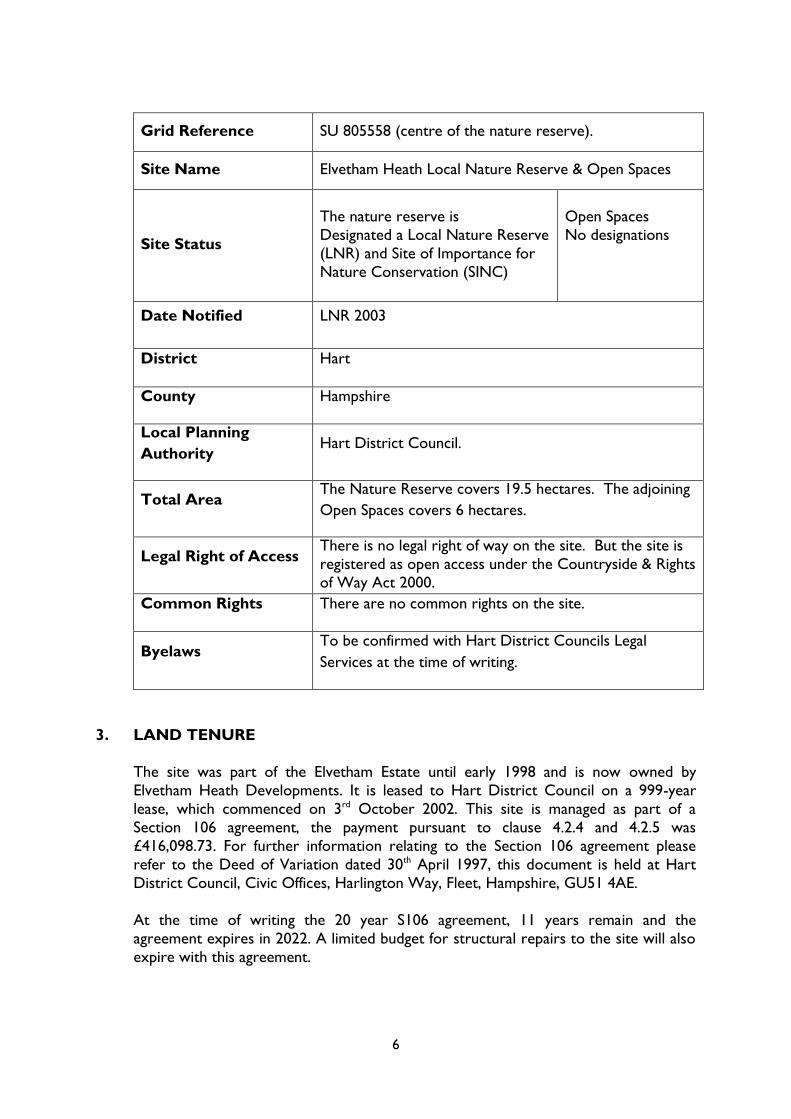
Grid Reference SU 805558 (centre of the nature reserve).
Site Name Elvetham Heath Local Nature Reserve & Open Spaces
Site Status
The nature reserve is
Designated a Local Nature Reserve
(LNR) and Site of Importance for
Nature Conservation (SINC)
Open Spaces
No designations
Date Notified LNR 2003
District Hart
County Hampshire
Local Planning
Authority Hart District Council.
Total Area The Nature Reserve covers 19.5 hectares. The adjoining
Open Spaces covers 6 hectares.
Legal Right of Access There is no legal right of way on the site. But the site is
registered as open access under the Countryside & Rights
of Way Act 2000.
Common Rights There are no common rights on the site.
Byelaws To be confirmed with Hart District Councils Legal
Services at the time of writing.
3. LAND TENURE
The site was part of the Elvetham Estate until early 1998 and is now owned by
Elvetham Heath Developments. It is leased to Hart District Council on a 999-year
lease, which commenced on 3rd October 2002. This site is managed as part of a
Section 106 agreement, the payment pursuant to clause 4.2.4 and 4.2.5 was
£416,098.73. For further information relating to the Section 106 agreement please
refer to the Deed of Variation dated 30th April 1997, this document is held at Hart
District Council, Civic Offices, Harlington Way, Fleet, Hampshire, GU51 4AE.
At the time of writing the 20 year S106 agreement, 11 years remain and the
agreement expires in 2022. A limited budget for structural repairs to the site will also
expire with this agreement.

7
4. SITE INFORMATION
Elvetham Heath Local Nature Reserve and Open spaces are a relatively new creation
and make up part of an extensive landscape design for the housing estate known as
Elvetham Heath Developments. Existing on the former plantations and heathlands of
Railroad Heath the development provided a high quality landscape design that can be
found throughout the estate. The nature reserve and open spaces together make up
26 Ha of natural green space.
The site is an integral part of the Elvetham Heath community and is used regularly by
local people and visitors. One of the key focal points of this landscape is the central
area of formal and informal open spaces centring on the Elvetham Heath Local Nature
Reserve. The site entrance leads to a formal pond picnic area to a wild natural
landscape of lowland heathland and mires. This informal landscape is encapsulated
with many formal areas including quiet seated areas around ponds, a tranquil picnic green and a formal play area. These are all interconnected with foot and cycle paths
that run throughout the development and further afield to the neighbouring
communities of Fleet Town and Ancells Farm.
The nature reserve is a designated Local Nature Reserve (LNR) and is approximately
19.5 hectares in size with habitats ranging from heathland and mire, wet woodlands
and open wet areas with aquatic vegetation. Conservation grazing is carried out during
the spring, summer and autumn and has been successfully implemented using a local
grazier‟s rare breed cattle for the last nine summers, with local people fully supporting
the use of livestock to maintain the heathland areas.
Access in and around the site is first-class with gates and pathways being fully
accessible to full and reduced mobility site users. There are gravel pathways and raised
boardwalks over wet areas. Kissing gates allow access into the nature reserve, which
are suitable for wheelchairs, pushchairs and bicycles. Local people use the site a great
deal, and many residents have a strong sense of ownership for their nature reserve.
Environmental education associated with the reserve includes walks, talks,
promotional events and further education projects. News and information is regularly
published in the local newsletter and articles in the press about the site have been
frequent.
5. LEGAL OBLIGATIONS
Successful management and the safeguarding of the site will be dependant upon
compliance with the following list of both legal and non-legal obligations:
The Wildlife & Countryside Act 1981
Countryside & Rights of Way Act 2000
Health and Safety at Work Act 1974
Occupiers Liability Act 1957
Hart District Council Local Plan 1996

8
6. HEALTH AND SAFETY SUMMARY
All work done on Elvetham Heath is in line with our Corporate Health and Safety Policy and
our departmental Health and Safety document. Specific risk assessments have been
completed for all site activities/works and a task risk assessment is done before any
volunteer days. Hazard trees are surveyed annually in line with our corporate Tree Safety
Policy and all site structures are surveyed annually for safety issues and any damage or
repairs are completed appropriately.
7. MAP 1- Site map Elvetham Heath Nature Reserve
All map templates within this plan are Copyright - DAB Graphics

9
7. SITE INFRASTRUCTURE
The developer, Elvetham Heath Developments, was responsible for setting up the
infrastructure of the reserve and Hart District Council is now responsible for the
ongoing management of the site.
There are gravel pathways and raised boardwalks over wet areas. Kissing gates allow
access into the reserve, which are suitable for wheelchairs, pushchairs and bicycles.
Treated timber post and rail fencing is around the reserve boundary and a 10.5m by
9.5m livestock corral and 3.4m by 10.6m holding pen is located within the reserve for
the loading and unloading of livestock. A 2.5m high chain link fence runs along the M3 /
nature reserve boundary.
Dip wells have been installed at key points in the nature reserve. These dip wells were
initially installed to monitor the effects of the ongoing building works on water levels
within the reserve. Some of these dip wells have been damaged and one has been removed due to vandalism.
Interpretation is provided in the form of oak „Welcome Boards‟ positioned at three
key entrance points to the site. Three interpretation panels comprising of steel
frames, artwork panels and notice boards are positioned at entrance / exit points to
the nature reserve, as well as three additional notice boards.
Contained within the site is a Thames Water pipeline and pumping station of 20m by
20m contained within a 2m high security palisade steel fence. An ecoturf (porous
paving) roadway runs from the site boundary to the pumping station and access must
be maintained to the pumping station, although vehicular access is infrequent.
Adjacent to the playing field there is a play area. It comprises of a safety surface wet
pour surrounded by a wooden fence, with 2 access gates. Structures include 1 Metal
multi-play unit (GT Rocket station), 2 Rocket Ship Springs, 1 Space rotator, 2 No
Cradle seat Swings, 1 Bin, 2 Seats and 2 Signs on both entrance gates.
Within the nature reserve are two strategic overhead electricity supplies on pylons
and poles. These consist of an 11kV and a 33kV overhead line.

10
8. MAP 2 – Site Infrastructure
9. ENVIRONMENTAL INFORMATION
1. LANDSCAPE
Elvetham Heath lies within the Thames Basin and occupies land which rises from
a little over 60m above sea level in the eastern part of the development to
around 85m above sea level in the west. The reserve lies towards the eastern
part of the site and is on the Bracklesham Beds where the ground is quite wet.
The surrounding land use is residential and commercial development, although
there are other wildlife habitats in the district including heathland, woodland,
forestry plantation and wetlands.

11
2. PHYSICAL
The site is extremely wet, particularly in the winter months and areas of open
water remain even in the driest months of the summer. The nature reserve is
the final destinations of the housing developments sustainable urban drainage
system (SUDS). The site manager can not control this in-flow of water.
For information on the physical environment including soil type, hydrology,
drainage and water quality please refer to previous management plan (Elvetham
Heath Nature Reserve Management Plan, November 1999). This information has
been omitted from this management plan to maintain a concise format and due
to the irrelevance of this information now that the development has taken place.
3. CLIMATE
The annual mean temperature for North East Hampshire is around 10 C, or
slightly above this where urban heating effects are a factor. The mean daily
maximum temperature in July is about 21.5 C. The 25-year average is of 91
days per year when the afternoon maximum exceeds 20 C. The mean daily
temperature in January is about 4 C, but the mean minimum for the month is
1.2 C. The average number of nights with air frost per year is 53, but ground frosts may double this total and occur in every month except July. The air frost-
free period is late May until late September.

12
SECTION 2 – MANAGEMENT & SITE FEATURES -
1. INTRODUCTION TO MANAGEMENT OBJECTIVES
Each feature contains characteristics that management tasks focus on to enhance and
maintain. Several principle characteristics can be shared among the 9 features. The
following objectives are broken down into further categories.
2. MANAGEMENT OBJECTIVES
In order to enhance and maintain the features of the site, 11 objectives have been identified:-
1. To enhance and maintain the heathland to benefit wildlife:-
i. To maintain and where possible actively increase the open areas of
heathland and to enhance the structural diversity of the heathland
vegetation.
ii. To create new wet scrapes and temporary pools to enhance wet boggy
areas and to increase open water habitats.
iii. To link up areas of heathland and wet heath/mire to form a joined up
habitat
2. To enhance and maintain the structural diversity of the woodland areas to
benefit wildlife:-
i. Optimise deadwood content in the woodland areas; retain standing dead
wood where H & S policy allows.
ii. Encourage regeneration of young native tree saplings and encourage an
increase in the diversity of ground flora and associated fauna through
gap/glade creation.
iii. Create additional habitats for woodland birds and mammals, such as the
installation of bat and bird boxes and repair of existing nest boxes.
3. To enhance and maintain a native wooded/scrub perimeter strip and visual
screen between the nature reserve, M3 motorway and the surrounding
development:-
i. Encourage regeneration of young native tree saplings
ii. Coppicing and pollarding of native deciduous trees, which promotes a
bushier denser tree canopy.
4. To restore, and thereafter maintain, the historic parish boundary as a prominent
ditch and bank system:-
i. To take considerable care when carrying out management prescriptions
within the vicinity of historic parish boundary to prevent damage to
historic parish boundary or prominent ditch and bank system
ii. Re-instate/re-profiling of banks or ditches where damage/natural processes has occurred, preferably with a mechanical digger.
iii. Report any suspected incidences of pollution immediately to the
Environment Agency.

13
5. To control and where practicable eradicate non-native and invasive plant
species:-
i. Where practicable cut and stump treat with pesticides non-native trees
and shrubs, notably Rhododendron.
ii. Where practicable eradicate and control bracken growth outside
woodland areas with pesticide spraying or mechanical means.
6. To prevent and reduce impact from misuse of the site, i.e. fly-tipping, vandalism,
illegal motorbike use and other anti-social behaviour:-
i. Where possible provide on-site interpretation, to facilitate communication,
education and information, which can help to reduce illegal activities.
ii. Log and report any illegal incidents to appropriate bodies. Maintain strong
links between the Countryside Service and the local Police, Fire & Rescue
Service, the Community Safety Team and individuals within the
community.
iii. Remove any fly-tipping to avoid invasive species taking hold, and to avoid encouraging others to fly-tip.
iv. Repair any breakages as a result of vandalism where possible, or remove
from the site any hazards resulting from vandalism or other activities.
7. To create and maintain an enjoyable and safe amenity for the local community:-
i. Keep paths open by cutting the edges back in the summer months.
ii. Maintain and repair bridges and other site structures.
iii. Remove any dead, dying or dangerous trees near to paths or properties.
iv. Litter pick regularly to maintain cleanliness.
v. Ranger site patrol to be a minimum of once fortnightly.
vi. Maintain and improve informal and formal landscaping within the
surrounding open spaces of the nature reserve, therefore enhancing vistas.
vii. Remove/Reduce scrub from areas that could be seen as a security issue.
8. To maintain and enhance a good relationship with the local community:-
i. To contribute towards providing environmental education for local people
ii. To provide volunteer and involvement opportunities for the local
community, including local interest groups, and corporations
iii. Help the local community attain a „sense of ownership‟ and to feel
informed about the nature reserve and the surrounding green space
9. To maintain and enhance access within the nature reserve and surrounding open
spaces:-
i. To optimise access within the nature reserve and surrounding open spaces
for visitors of all mobility levels
ii. To maintain pathways, boardwalks and access points in a favourable status
(to be available for use 365 days in the year)
iii. To maintain access levels at the nature reserve so that the nature
conservation features are not adversely affected
iv. To carry out annual Health & Safety inspections of access structures
10. To provide and maintain permanent and temporary interpretation for all visitors
to a high standard throughout the site.

14
i. To provide up to date relevant site information through the full range of
media; including Hart District Councils website, blogs, forums,
publications, press releases and onsite posters.
ii. All interpretation should be in line with Hart District Councils policies and
guidelines and must include relevant corporate logo‟s and designs
11. To manage the Nature Reserve in as sustainable way as possible:-
i. To provide methods of sustainability from materials on site.
ii. To provide our in-house grounds & maintenance team with woodchip to
suppress weed growth in flowerbeds and shrub boarders around the
development and Turner‟s pond.
iii. To create habitat piles from tree‟s felled on site if viable and if requested
from local schools for educational purposes.
iv. To graze cattle on site to suppress Purple Moor Grass (Molinia caerulea)
and invasive species such as Birch saplings, therefore providing a sustainable grazing regime.
3. DESCRIPTION OF SITE FEATURES
The site features have been chosen on the merit of biological, historical, amenity and
community value. The following descriptions are a brief summary of the site features,
which include some historical information. For additional habitat and biological
information, please see Appendix 1. All biological information on the site is also held
by Hampshire Biodiversity Records Centre.
Feature 1: Heathland and wet heath/mire
Feature 2: Native wet woodland
Feature 3: Wooded/scrub perimeter buffer
Feature 4: Historic ditch and bank system
Feature 5: Open spaces
Feature 6: The local community
Feature 7: Access
Feature 8: Interpretation

15
Feature 1: Heathland and Wet Heath/Mire community
MAP 3 – Extent of heathland and wet heath/mire community
CONSERVATION STATUS AND IMPORTANCE
Lowland heathland is a priority habitat under our UK Biodiversity Action Plan (BAP) and is
recognised as being internationally important under the Habitats Directive. It is the main
criteria used to give the site it‟s designation as a SINC. Restoration of heathland at this site
can help to link up other local heathlands such as Fleet Pond, Yateley Common, Castle
Bottom, Hazeley Heath and Bramshill, many of which also make up parts of the Thames
Basin Heaths Special Protection Area (SPA). There is a legal obligation for Hart District
Council to manage this feature in line with the ten-year Countryside Stewardship agreement
with Natural England.
DESCRIPTION
The Heathland areas comprise of a mosaic
of dry heath, wet heath and mire
communities and make up just under 50%
of the nature reserve (8-9 Ha). Wet
heath/mire is the dominant habitat to
emerge in the cleared areas of the reserve.
A range of heathland communities are
present, including an element of dry heath,
Figure 1: Grazing on the heath

16
species rich wet heath, mire communities and rush pasture. In the wetter areas of the
heath several boggy pools retain water throughout much of the year. These areas contain
several uncommon plant species including Round-leaved Sundew. On the less boggy ground
there is a humid heath community of Cross-leaved Heath, Heather and several kinds of
sedge. Large areas are also dominated by Purple Moor Grass.
A programme of heathland restoration
has been carried out since 2000 with the
aim of improving the quality of the heath
by removing large stands of mature pine,
reducing unwanted scrub and dominant
grasses and increasing heather and other
heathland species. Turf scraping of areas
dominated by Molinia and scrub and the
excavation of shallow pools in wet areas
has been carried out annually since the autumn of 2007. This form of
management has been highly successful
and large patches of heather and other
important heathland species have
returned. Piles of the top soil layer that
was scraped off have also become good habitats for small mammals, reptiles and
invertebrates, being covered by brambles and grasses etc.
Currently the general age structure of the heather is good with patches of pioneer, building
and some mature heather. Plant species such as Round-leaved and Oblong-leaved Sundew,
Bog Pimpernel, Heath Milkwort, Dodder and Lousewort are establishing after initial
heathland restoration. Whilst occurrence of these species is still sparse, the composition of
the emerging vegetation is a clear indication that the seed-bank of the site is still viable and
primed for successful restoration back to a diverse habitat.
OBJECTIVES
a. To enhance and maintain the heathland to benefit wildlife.
b. To restore, and thereafter maintain, the historic parish boundary as a prominent
ditch and bank system.
c. To control and where practicable eradicate non-native and invasive plant species.
d. To prevent and reduce impact from misuse of the site, i.e. fly-tipping, vandalism,
illegal motorbike use and other anti-social behaviour.
e. To create and maintain an enjoyable and safe amenity for the local community.
f. To create and thereafter maintain fire breaks to prevent the spread of wildfire by
isolating the fire from the remaining heath, giving valuable time for emergency
services to arrive and minimise damage and harm to remaining wildlife.
Figure 2: A heathland scrape

17
VISION
The open areas of the site are a combination of heathland and wet heath/mire with banks of
dry heath running along the ditches and on raised ground. Heathers dominate the open
heathland, although there is scattered scrub dotted around. Isolated trees, both living and
standing deadwood, provide plenty of song perches for birds through the otherwise shrubby
landscape.
The heathers are of different ages ranging from new growth to old layered plants. This
offers a varied structure that is of benefit to both butterflies, that prefer the shorter sward,
and reptiles that move about amongst the cover of the mature stems.
In amongst the heather are grasses such as purple moor grass and cotton grass, and other
wild flowers such as heath bedstraw, heath milkwort, heath speedwell and lousewort. These
give colour and variety during the spring and early summer before the majority of heather is
in flower.
There are areas of open water from wet ditches to large temporary pools, some are newly
established with areas of wet mud and exposed peat, while others are mature with reed
fringed edges and contain aquatic plants such as Bog Pondweed. These areas of open water
include a series of balancing ponds through the site; collectively they provide a home to a
wide range of flora and fauna, especially dragonflies and damselflies.
Periodic grazing by livestock maintains these open areas of water and bare ground and the
rare sundew thrives in these disturbed patches. The impressive raft spider can also be seen
here. The heathland areas remain open and contain scattered trees and scrub. Areas of bare
ground and wet hollows are present and there is a lack of invasive and/or non-native plant
and tree species.
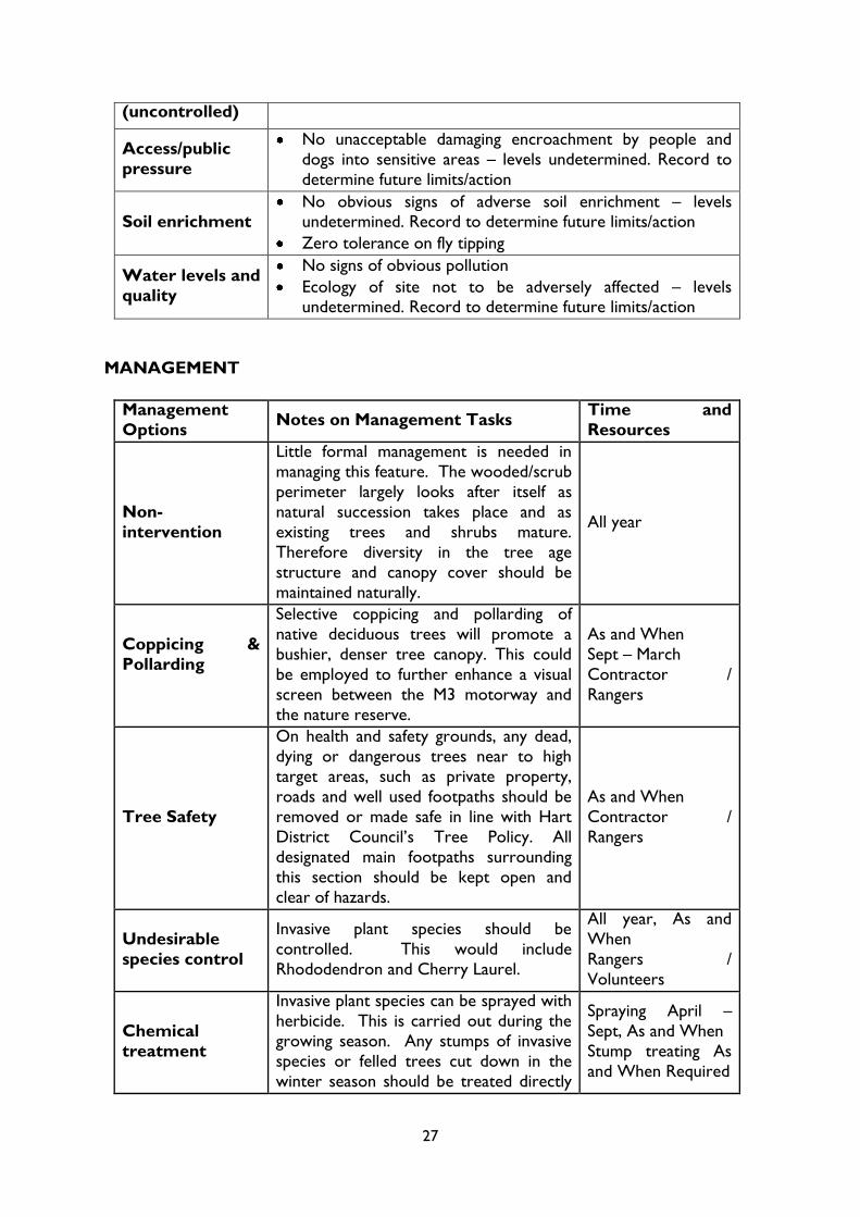
PERFORMANCE INDICATORS
Based on HLS indicators of success, these performance indicators give an indication as to
the status of the feature. When the factors and attributes of the feature as listed below are
found to be within the upper and lower limits, the feature is said to be in favourable
conservation status.
Attribute Target
Area or extent
No reduction in total area of heathland and wet heath/mire
from current condition
Increase total area to not more than 75% of the site
To link up areas of heathland and wet heath/mire
Bare ground Not more than 5% bare ground
Not less than 1% bare ground
Vegetation
composition/
structure
Ericaceous plants – between 70 – 90% cover
There should be a wide range of age classes of dwarf shrubs
present. This should include between 10% and 15% cover of
pioneer stage / between 10% and 30% cover of degenerate

18
stage and no more than 10% cover of dead dwarf shrubs
Grass tussocks should be allowed to persist without allowing
a build up of deep thatch
Cover of Common Gorse should be between 2% and 10%.
Grasses (graminoids) and other flowering plants – between 20
– 50% cover
Native scrub species – between 5 – 15% cover
At least 2 desirable wildflower species such as sundew and
bog pimpernel should be occasional.
Cover of bryophytes and lichens should be at least 10%.
Indicators of local distinctiveness
Open pools and boggy areas to be maintained, created and allowed to develop
Factor Target
Grazing
No over grazing (destruction of heather plants, heavy poaching etc) - upper limit eight livestock units
Not under grazed (unacceptable scrub encroachment,
dominance by Molinia etc) – lower limit four livestock units
Indicators of
negative change
Rhododendron & other non native invasive plants - no
flowering plants
Bracken – not more than 5% cover
Scrub & Pine encroachment – no visible dominance by any
species
Fire control Fire breaks to be maintained around high risk areas
Fire access markers to be erected around site for emergency
services
Access/public
pressure
No unacceptable damaging encroachment by people and dogs
into sensitive areas – levels undetermined. Record to
determine future limits/action
Water levels and
quality
No signs of obvious pollution
Ecology of site not to be adversely affected – levels
undetermined. Record to determine future limits/action
Soil enrichment
No obvious signs of adverse soil enrichment – levels
undetermined. Record to determine future limits/action
Zero tolerance on fly tipping
MANAGEMENT
Management
Options Notes on Management Tasks Time and Resources
Grazing
Continue with the grazing strategy to reduce
Purple Moor Grass and scrub. A stocking
rate of about 4 cows is appropriate.
Spring – Autumn
Turf cutting
& scraping
Areas dominated by Purple Moor Grass can
be scraped to sandy soil layer to expose the
existing heather seed bank; this will
encourage the growth of new heather and
2 days/yr
Sept – March
Contractors

19
other heathland species. Any tree removal
should be followed up by scraping to restore
the heathland.
Mowing
Mowing old patches of heather will encourage
the growth of new heather to maintain age
structure diversity. A mower can also be used to suppress birch saplings.
This is carried out using either a tractor and a
cut and collect mower or a brush cutter. Cut
material is removed from the heath.
1 day / yr Sept – March
Rangers
Scrub control
Birch/Alder/Willow scrub should be
controlled. Gorse should also be controlled
to maintain age structural diversity.
Invasive and undesirable plants should also be
controlled, including bracken which is present
in patches and should be prevented from encroaching on the heath.
Large trees can be cut with chainsaws and/or
clearing saws. Any smaller trees and scrub
can be cut or dug up using hand tools. Cut
material is removed from the heath.
2 – 3 days / yr,
Sept – March
Contractor / Rangers /
Volunteers
Chemical
treatment
Stumps from cut trees can be treated with
approved herbicides to prevent re-growth.
This is generally done in winter. Invasive
plant species and bracken can be sprayed
with an approved herbicide. This is carried out during the growing season.
1 day spraying / yr,
April - Sept
Stump treating As and
When Required Rangers / Contractors
An action plan for management tasks follows in Section 3
MONITORING
Status assessments
Botanical surveying every 5 years
Invertebrate surveying every 5 years Fixed point photography
Dip-well water level monitoring
These surveys help assess the success of previous habitat management and give an indication
of recommended future management programmes.

20
Figure 3: Pollarding
Feature 2 – Native Wet Woodland
MAP 4 – Extent of native wet woodland
CONSERVATION STATUS AND
IMPORTANCE
The Wet Woodland at Elvetham Heath is
one of the main criteria used to give the
site it‟s designation as a SINC. Wet
woodland is a BAP priority habitat due to
the levels of decline it has undergone. It
supports a large number of bird species
throughout the year as well as other animal
groups. Willow has a large number of
invertebrates associated with it and the
ground flora in wet woodlands is very
diverse, and often includes rare or notable
species. Standing deadwood and deadwood

21
on the ground also means a very diverse fungi population often exists.
DESCRIPTION
The management of the retained native wet woodlands (both the alder and willow/birch
carrs) will improve the wildlife diversity. Management for diversity will mean that the
structure of these woodlands will gradually convert from a monoculture,
uniform woodland to a more natural
dynamic system where there will be a
combination of high canopy, understory
and ground layers. This varied structure
will in turn provide shelter and food to
support populations of birds and mammals
as well as invertebrates and fungi.
The alder carr area has evidence of a
historic coppicing regime and when in the
wood itself there is a feeling of a natural
monoculture. Mature coppice stools are
evident in large number, especially along
the M3 motorway boundary. Willow carr
is potentially an extremely valuable habitat
for invertebrates, supporting a greater number of species than oak. Species diversity can be
optimised by having all the different stages of growth of the trees. The two willow/birch wet
woodlands are very dynamic and have good natural regeneration potential.
OBJECTIVES
1. To enhance and maintain the structural diversity of the woodland areas to benefit
wildlife.
2. To restore, and thereafter maintain, the historic parish boundary as a prominent
ditch and bank system
3. To control and where practicable eradicate non-native and invasive plant species.
4. To prevent and reduce impact from misuse of the site, i.e. fly-tipping, vandalism,
illegal motorbike use and other anti-social behaviour.
5. To create and maintain an enjoyable and safe amenity for the local community, such as increasing visibility and removing hazard trees.
VISION
The wet woodland has a wild and natural feel to it. Native broad-leaved species that enjoy
the wet conditions, such as willows, birch and alders dominate the woodland. Some areas of
ground remain periodically water-logged, with areas of boggy or saturated substrate; these
can be seasonal or permanent.
Alder, willow and birch can be seen in different age ranges and sizes (including coppice
stools) within the woods, with the occasional rowan, aspen and oak amongst them. The old
Figure 4: Glade creation 2010

22
mature coppice stools exhibit healthy re-growth and the younger stools provide variety in
the canopy layers.
The woodland is a dynamic habitat with temporary open areas, which are maintained as far
as possible by natural processes. Young seedlings and saplings will develop in the open
glades and there will be a patchwork of vegetation communities. Deadwood, standing, hung
up and on the floor is plentiful, so a variety of deadwood dependant species such as fungi,
mosses and invertebrates will flourish.
Soft grasses and woodland flowers such as wood sorrel and primroses can be found on the
woodland floor along with honeysuckle and nettles, making the open glades ideal for
butterflies. There are large tussocks of grasses, and mosses forming large hummocks across
the woodland floor, amongst which numerous froglets can be seen hopping about during
spring and early summer as they spread out from their spawning sites.
This is an excellent place to see birds such as the green woodpecker, the greater-spotted
woodpecker and the shy tree creeper. At dusk and throughout the evening bats can be seen using the woodland as they emerge from their roosts to forage and commute to nearby
feeding grounds. Plant and tree species associated with dry conditions are lacking as are
non-native plant and tree species. Species such as rhododendron are not tolerated and any
plants that persist will be targeted in management projects and volunteer activities.
PERFORMANCE INDICATORS
Attribute Target
Area or extent Two distinct wet woodland areas to be retained
Structure and
natural
processes
A diverse age and height structure to the woodland
Tree Species alder / willow / birch should be present at irregular
spacing‟s, with an overall canopy cover of between 50 - 90%
Under storey / scrub present - between 10 - 30% of area
Not less than 10% of the woodland should be open (a mixture of
permanent and temporary gaps)
High levels of deadwood. Standing wherever possible but safely
„hung up‟ or on the ground where Health and Safety dictates
Transitions between stages over time occur
Regeneration
potential
Seedlings, saplings and young trees show signs of growing through
to maintain canopy density into the future
Natural regeneration from trees on site, not from plantings
No obvious signs of over grazing of regenerating trees
Vegetation
composition
(trees and
shrubs)
Native species are dominant. Willow, alder and birch to dominate
No flowering plants of non-native species
Absence of Rhododendron
23
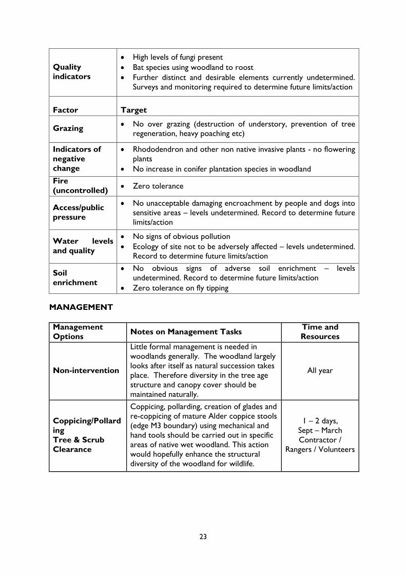
Quality
indicators
High levels of fungi present
Bat species using woodland to roost
Further distinct and desirable elements currently undetermined.
Surveys and monitoring required to determine future limits/action
Factor
Target
Grazing No over grazing (destruction of understory, prevention of tree
regeneration, heavy poaching etc)
Indicators of
negative
change
Rhododendron and other non native invasive plants - no flowering
plants
No increase in conifer plantation species in woodland
Fire
(uncontrolled) Zero tolerance
Access/public
pressure
No unacceptable damaging encroachment by people and dogs into
sensitive areas – levels undetermined. Record to determine future
limits/action
Water levels
and quality
No signs of obvious pollution
Ecology of site not to be adversely affected – levels undetermined. Record to determine future limits/action
Soil
enrichment
No obvious signs of adverse soil enrichment – levels
undetermined. Record to determine future limits/action
Zero tolerance on fly tipping
MANAGEMENT
Management
Options Notes on Management Tasks
Time and
Resources
Non-intervention
Little formal management is needed in
woodlands generally. The woodland largely
looks after itself as natural succession takes
place. Therefore diversity in the tree age
structure and canopy cover should be
maintained naturally.
All year
Coppicing/Pollard
ing
Tree & Scrub
Clearance
Coppicing, pollarding, creation of glades and
re-coppicing of mature Alder coppice stools
(edge M3 boundary) using mechanical and
hand tools should be carried out in specific
areas of native wet woodland. This action
would hopefully enhance the structural
diversity of the woodland for wildlife.
1 – 2 days,
Sept – March
Contractor /
Rangers / Volunteers

24
Tree Safety
On health and safety grounds, any dead,
dying or dangerous trees near to high target
areas, such as private property, roads and
well used footpaths should be removed or
made safe in line with Hart District
Council‟s Tree Policy. An annual site
inspection is undertaken to establish
potential dangers. All designated main
footpaths surrounding this section should
be kept open and clear of hazards.
As and When
Contractor /
Rangers
Undesirable
species control
Invasive plant species should be controlled.
This would include Rhododendron and
Cherry Laurel.
All year, As and
When
Rangers / Volunteers
Chemical
treatment
Invasive plant species can be sprayed with
herbicide. This is carried out during the
growing season. Any stumps of invasive
species or felled trees cut down during the
winter season should be treated directly
after cutting.
Spraying
April - Sept
Stump treating As
and When Required
An action plan for management tasks follows in Section 3
Monitoring
Status assessments
Botanical surveying
Invertebrate surveying
Fixed point photography
Dip-well water level monitoring

25
Feature 3 – Wooded/Scrub Perimeter Buffer
MAP 5 – Extent of wooded/scrub perimeter buffer
DESCRIPTION
The development, and thereafter maintenance, of a wooded/scrub buffer around the
perimeter of the reserve is of importance in the context of the local residents and the
development. Residents and site users place a great deal of importance on this screening
and as a result it will be retained and improved, and treated as a feature in its own right in
order to define management projects to establish and develop this perimeter strip to a
suitable state. However, management away from a tall canopy of pine with rhododendron
understory to a mixed deciduous canopy layer should be encouraged. Management
techniques should be used to achieve this and native species encouraged to provide a visual
screen from, and for, houses and roads.
There is also a desire to have a combination of open heathland areas and woodlands to
provide a variety of habitats for site users to enjoy. The development of a wooded/scrub
buffer has also been identified as being of importance due to the high density development
around the nature reserve. Visual and audio screening is a key reason why trees and scrub
should be retained around the outside of the reserve.

26
OBJECTIVES
1. To enhance and maintain a native wooded/scrub perimeter strip and visual screen
between the nature reserve, M3 motorway and the surrounding development.
2. To restore, and thereafter maintain, the historic parish boundary as a prominent
ditch and bank system 3. To control and where practicable eradicate non-native and invasive plant species.
4. To prevent and reduce impact from misuse of the site, i.e. fly-tipping, vandalism,
illegal motorbike use and other anti-social behaviour.
5. To create and maintain an enjoyable and safe amenity for the local community.
VISION
The site retains a buffer of trees and shrubs around its perimeter which restricts views of
the surrounding development and M3 motorway. This buffer consists of native species, such
as birch, willow, alder, rowan, aspen, oak and gorse. Tall Scott‟s pine trees intersperse the
skyline giving a sense of height and grandiose. There is a diverse age and height structure to
all the plants, providing dense screening from ground level right up to the highest canopy
layer.
The buffer provides excellent foraging for birds, butterflies and mammals throughout the
year as it provides pollen, flowers, catkins, seeds and berries along with an associated
invertebrate assemblage. The dense growth means birds have an additional habitat to nest
and feed as well as the areas of woodland.
PERFORMANCE INDICATORS
Attribute Target
Area or extent A buffer strip to extend along the reserve perimeter
predominantly where there is no woodland screening
Structure and
natural
processes
A diverse age and height structure to the strip
Transitions between stages over time occur
Tall trees also occur throughout the strip
Regeneration
potential
Seedlings, saplings and young trees show signs of growing
through to maintain the strip into the future
Natural regeneration preferred from trees on site, not from plantings.
Vegetation
composition
(trees and shrubs)
Native species are dominant
No flowering plants of non-native species (particularly rhododendron)
Quality
indicators Birds and invertebrates use the strip for feeding and nesting
Adequate screening from nearby development
Factor Target
Fire Zero tolerance
27
(uncontrolled)
Access/public
pressure
No unacceptable damaging encroachment by people and
dogs into sensitive areas – levels undetermined. Record to
determine future limits/action
Soil enrichment No obvious signs of adverse soil enrichment – levels
undetermined. Record to determine future limits/action
Zero tolerance on fly tipping
Water levels and
quality
No signs of obvious pollution
Ecology of site not to be adversely affected – levels undetermined. Record to determine future limits/action
MANAGEMENT
Management
Options Notes on Management Tasks
Time and
Resources
Non-
intervention
Little formal management is needed in
managing this feature. The wooded/scrub
perimeter largely looks after itself as
natural succession takes place and as
existing trees and shrubs mature.
Therefore diversity in the tree age
structure and canopy cover should be
maintained naturally.
All year
Coppicing &
Pollarding
Selective coppicing and pollarding of
native deciduous trees will promote a
bushier, denser tree canopy. This could
be employed to further enhance a visual
screen between the M3 motorway and
the nature reserve.
As and When
Sept – March
Contractor /
Rangers
Tree Safety
On health and safety grounds, any dead,
dying or dangerous trees near to high
target areas, such as private property,
roads and well used footpaths should be
removed or made safe in line with Hart
District Council‟s Tree Policy. All
designated main footpaths surrounding
this section should be kept open and
clear of hazards.
As and When
Contractor /
Rangers
Undesirable
species control
Invasive plant species should be
controlled. This would include
Rhododendron and Cherry Laurel.
All year, As and
When
Rangers /
Volunteers
Chemical
treatment
Invasive plant species can be sprayed with
herbicide. This is carried out during the
growing season. Any stumps of invasive
species or felled trees cut down in the
winter season should be treated directly
Spraying April –
Sept, As and When
Stump treating As
and When Required

28
after cutting.
An action plan for management tasks follows in Section 3
MONITORING Status assessments
Botanical surveying
Invertebrate surveying
Fixed point photography
Dip-well water level monitoring

29
Feature 4 – Historic Ditch and Bank System
MAP 6 – Extent of historic ditch and bank system
DESCRIPTION
The historic parish boundary and open water course running through the site form part of
the local SUDs. The parish boundary is the only historical feature on site and therefore
should be retained as a feature of interest in its own right.
This ancient parish boundary crosses through the entire development of Elvetham Heath,
and a section of it is contained within the nature reserve. It can be seen in the form of a
ditch and bank system and originally marked the boundary between the Hundreds of
Crondall (to the east) and Odiham (to the west) and dates back to the 9th Century.
A „Hundred‟ was the term used in Saxon times for dividing the land required to support and raise 100 „men-at-arms‟. In 885, Alfred the Great, the Saxon King bequeathed the Hundred

30
of Crondall to his nephew Eltham. Eltham is believed to be the origin of the name
„Elvetham‟. Therefore, the parish
boundary is more than 1000 years old,
and the bank was probably formed over
the centuries by digging out the ditch.
The stream continued to form the parish
boundary until 1836 when Fleet was
created from parts of the former
parishes of Crondall, Elvetham and
Yateley.
Although some of the bank has been
damaged, much of the feature is now
open and free from dominant conifer species. It is also showing signs of native regeneration
from the seed-bank, so clearly restoration/recovery management is appropriate and should
be continued.
OBJECTIVES
1. To restore, and thereafter maintain, the historic parish boundary as a prominent
ditch and bank system
2. To control and where practicable eradicate non-native and invasive plant species.
3. To prevent and reduce impact from misuse of the site, i.e. fly-tipping, vandalism,
illegal motorbike use and other anti-social behaviour.
4. To create and maintain an enjoyable and safe amenity for the local community.
VISION
The section of ancient parish boundary within the nature reserve can be seen in the form of
a ditch and bank system. The structural integrity of the ancient bank within the nature
reserve remains intact. The historic ditch
and bank of the old parish boundary is a
prominent and obvious feature of interest.
It has established high banks indicating the
years of cultural importance when our
ancestors would have repeatedly dug out
the ditch to maintain the boundary
between parishes.
The raised banks provide dry, sandy areas
where species of dry-ground loving plants,
such as bell heather can grow, and insects,
such as heathland mining bees or solitary
wasps, can use the south facing slopes for burrowing. These raised banks provide a
contour in the landscape which, albeit small, is otherwise unavailable.
Figure 6: Parish boundary bank
Figure 5: Ditch with running water
31
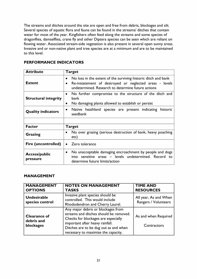
The streams and ditches around the site are open and free from debris, blockages and silt.
Several species of aquatic flora and fauna can be found in the streams/ ditches that contain
water for most of the year. Kingfishers often feed along the streams and some species of
dragonflies, damselflies, crane fly and other Diptera species can be seen which are reliant on
flowing water. Associated stream-side vegetation is also present in several open sunny areas.
Invasive and or non-native plant and tree species are at a minimum and are to be maintained
to this level.
PERFORMANCE INDICATORS
Attribute Target
Extent
No loss in the extent of the surviving historic ditch and bank
Re-instatement of destroyed or neglected areas - levels
undetermined. Research to determine future actions
Structural integrity
No further compromise to the structure of the ditch and
bank
No damaging plants allowed to establish or persist
Quality indicators Native heathland species are present indicating historic
seedbank
Factor Target
Grazing No over grazing (serious destruction of bank, heavy poaching
etc)
Fire (uncontrolled) Zero tolerance
Access/public
pressure
No unacceptable damaging encroachment by people and dogs
into sensitive areas – levels undetermined. Record to
determine future limits/action
MANAGEMENT
MANAGEMENT
OPTIONS
NOTES ON MANAGEMENT
TASKS
TIME AND
RESOURCES
Undesirable
species control
Invasive plant species should be
controlled. This would include
Rhododendron and Cherry Laurel.
All year, As and When
Rangers / Volunteers
Clearance of
debris and
blockages
Any major debris or blockages from
streams and ditches should be removed.
Checks for blockages are especially
important after heavy rainfall.
Ditches are to be dug out as and when
necessary to maximise the capacity.
As and when Required
Contractors
32
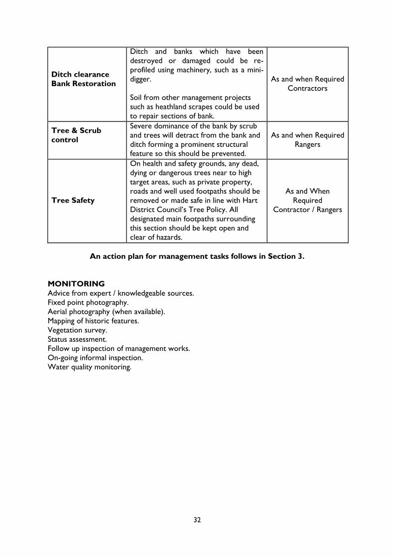
Ditch clearance
Bank Restoration
Ditch and banks which have been
destroyed or damaged could be re-
profiled using machinery, such as a mini-
digger.
Soil from other management projects
such as heathland scrapes could be used
to repair sections of bank.
As and when Required
Contractors
Tree & Scrub
control
Severe dominance of the bank by scrub
and trees will detract from the bank and
ditch forming a prominent structural feature so this should be prevented.
As and when Required
Rangers
Tree Safety
On health and safety grounds, any dead,
dying or dangerous trees near to high
target areas, such as private property,
roads and well used footpaths should be
removed or made safe in line with Hart
District Council‟s Tree Policy. All
designated main footpaths surrounding
this section should be kept open and
clear of hazards.
As and When
Required
Contractor / Rangers
An action plan for management tasks follows in Section 3.
MONITORING
Advice from expert / knowledgeable sources.
Fixed point photography.
Aerial photography (when available).
Mapping of historic features.
Vegetation survey.
Status assessment.
Follow up inspection of management works.
On-going informal inspection.
Water quality monitoring.

33
Feature 5 – Open Spaces
MAP 7 – Extent of open spaces
DESCRIPTION
This formal landscape includes quiet seated
areas around ponds, a tranquil picnic green
and a formal play area. These are all
interconnected with foot and cycle paths
that run throughout the development and
further afield to the neighbouring
communities of Fleet Town and Ancells
Farm.
The focal point of this feature is Turners
Pond. This man-made pond was
constructed as part of the development in
early 2000 and is lined with Butyl rubber. A Figure 7: Recreation area Turners Pond

34
drainage channel carrying surface water
from Elvetham Heath Way enters the
water body via a culvert into the south-
western edge of the pond. A culvert on
the North-eastern pond edge takes
over-flow water into the nature
reserve via a metre wide natural
channel.
This is primarily a wildlife pond which
supports several species of dragonfly
and damselfly. Common species of
waterfowl can be found here. Fishing is
not permitted on this water. The pond is
surrounded by a landscape comprising of planted trees and scrub beds, and lawns. Picnic
benches and other seating are situated close to the pond to facilitate enjoyment of this
formal green space. Recent pond bank restoration work has been carried out to improve
the amenity value of the site.
A series of reed fringed ponds and ditches are located throughout the site, which form the
Sustainable Urban Drainage System of the estate (SUDS). See Section 4 (Sustainability)
number 2.1 for more information.
The SUDS are made up of a series of ponds and ditches varying in shape, size and depth.
Many of these pools contain aquatic vegetation and form transitional wetland zones between
other habitat types, namely Common Reed. They support a range of invertebrates such as
dragonflies, damselflies and native amphibians. These pools act as a buffer zone between the
housing estate and the nature reserve. Ultimately, the provision of SUDS at Elvetham will
enhance the local biodiversity whilst providing a sustainable method in managing flooding
and the affects of pollution.
Within the open spaces there is a play area, which was developed as part of the housing
development.
OBJECTIVES
1. To prevent and reduce impact from misuse of the site, i.e. fly-tipping, vandalism,
illegal motorbike use and other anti-social behaviour.
2. To create and maintain an enjoyable and safe amenity for the local community.
VISION
We intend to keep the open spaces maintained to a high standard, with grass cutting and
shrub beds regularly visited and monitored. Picnic areas will be kept clean and tidy to
encourage people to use the facilities and increase usage of the open space.
Figure 8: Children’s Play Area

35
The open spaces provide a safe, clean and pleasant environment for people to enjoy their
free time. With ample space for people to walk, cycle, picnic or just relax. By encouraging
people to visit Elvetham Heath‟s open spaces we aim to improve their health and wellbeing.
PERFORMANCE INDICATORS
Attribute Target
Extent No loss in the extent of the formalized open spaces
Maintenance of
vegetation (trees,
grass and shrub
beds)
Grass to be kept short throughout the growing season
No weeds/invasive plant species in shrub and flower beds
Shrubs and trees to be pruned and maintained in keeping with
a formalised landscape
Play Area
No loss in structural integrity of all play equipment and
associated structures
No reduction in safety inspections
Quality indicators
Landscaping free of litter and fly-tipping
Grass mown tightly and free of invasive weeds
Flower and shrub beds free of weeds and disease, plants
showing vitality
Footpaths free of damage and clear of vegetation
SUDS – drainage unimpeded and free of established trees
Ditches clear and drainage unimpeded
Pond - free of pollutants, absence of fish, duck house free of
damage and intact, banks intact with 70% marginal vegetation
present
Picnic and other benches free of damage
Play Area – free of damage and safe for children to play on
Factor Target
Weather
Conditions Sympathetic management in adverse weather conditions
Access/public
pressure
No unacceptable damaging encroachment by people and dogs into sensitive areas – levels undetermined. Record to
determine future limits/action
Litter not allowed to accumulate

36
MANAGEMENT
Management
Options Notes on Management Tasks
Time and
Resources
*Selected tasks are based on 3 man
team and work over a one year period. Grounds maintenance is managed via a
partnership agreement with Basingstoke and
Dean Borough Council to supply a grounds
maintenance service to Hart District Council
via its in-house service. The Grounds and
Countryside Manager will oversee this
partnership agreement.
Pond
Maintenance
Management is reactive as and when
problems arise.
Recent work has involved the installation of a timber framed duck house, removing
introduced fish species and repairing the
pond lining and erosion of pond edges.
Marginal plant plugs covered with goose
protection fencing was installed on the pond
edge in early 2009 to stabilise the pond bank
edges. This fencing has now been removed as
the bank side is now stable.
In freezing conditions, if the pond is partially
or completely frozen over, appropriate
Health & Safety warning signs should be
displayed in the interests of public safety. In
these conditions the pond should be
monitored on a regular basis.
Fish removal / As and
When
Contractor Bank and lining repair
/ As and when
Contractor
Duck House clean out
/ Every Autumn
Rangers
Duck House repair,
replacement / As and
When
Rangers
Site patrols Ice/snow
– installation H & S
signs / As and When
Rangers
*SUDS/
Balancing
Ponds
The individual ponds or swales need periodic
clearing out of scrub and debris to facilitate
drainage and to prevent the establishment of
woodland. This will typically be done every
three to five years. Scrub is removed with
brush cutters and hand tools and all cut
stumps are treated.
It may be necessary to remove silt if a
particular pond impedes drainage from the
housing estate. This would need to be done
with a mechanical digger.
The balancing pond maintenance will be
carried out by Basingstoke and Dean
Borough Council‟s in-house service and
specialist contractors. Thames Water Plc has
overall responsibility for the SUDs.
Scrub Clearance
3 days every 3-5 yrs
Contractor
Litter Pick / As and
When
*Grass
Cutting &
Strimming
All grass areas, including play grounds, are cut
once every four weeks during the growing
season. Grass cut with ride on mowers and
8 cuts (96hrs)
annually

37
trimmers, with all arisings left on site to
break down naturally so as not to remove
nutrients. All arising will be blown off paths
and back onto grass areas.
Strimming around trees, posts, buildings,
fences and other furniture to take place with
grass cutting.
*Paths
Footpaths are sprayed with glyphosate twice
a year to keep weeds at bay, the condition of
the path is monitored at this time and any
repairs required will be carried out.
Spray with herbicide
twice yearly (6hrs)
Contractor
*Flower and
Shrub Beds
To be weeded as and when weeds appear
and between March and October. Flowering
plants to be pruned and deadheaded as
required. Replanted as required. Mulched
using recycled materials. Shrubs to be trimmed twice a year either end of the bird
nesting season.
2 cuts plus weeding
(144 hrs)
Contractor
*Ditches and
Culverts
Ditches are regularly inspected and any major
blockages removed. Major clearance work is
carried out every two years. Checks for
blockages are especially important after
heavy rainfall.
Ditch Inspections 0.5
days / yr
Ditch Clearance 1 day
/ yr
Contractor
Litter
Picking
Bins
Open spaced litter picked and all bins
emptied weekly by the Waste and Street
Cleaning contractor.
Nature reserve litter picked by site ranger a
minimum of once a week.
Litter picking & Bins /
Once Weekly
Waste and Street
Cleaning contractor
Litter Picking
Rangers once weekly
Play Area
Play equipment ROSPA checked weekly by
qualified staff with more detailed check 6
monthly by specialist from the Districts
Insurance Provider. Repairs to / replacement
of worn or damaged equipment carried out
as required. Leaves and other debris cleared
on a weekly basis. Bark or sand topped up as
required. Paths and fence checked regularly.
Inspection
Once Weekly
52 hrs annually
Dog Warden
Close links with HDC dog warden re: dog
fouling and anti social behaviour. Dog litter
signs at all main access points. All issues
relating to dogs should contact the
Environmental Health Department.
As and When
HDC Dog Warden /
Rangers
Site
Structures
Structural and other site inspections. Repairs
and replacements as & when required &
highlighted in annual inspections. These
include bins, seating, bridges, boardwalks,
fencing, rails, signs and footpaths.
Site Inspections /
Once Fortnightly
Structural Inspection /
1 Day Yr
Rangers

38
Tree Safety
On health and safety grounds, any dead, dying
or dangerous trees near to high target areas,
such as private property, roads and well used
footpaths should be removed or made safe in
line with Hart District Council‟s Tree Policy.
All designated main footpaths surrounding
this section should be kept open and clear of
hazards.
As and When
Required
Contractor / Rangers
An action plan for management tasks follows in Section 3.
MONITORING
Monitoring will be carried out by the Grounds and Countryside Manager over the course of
any one year and will be reactive and proactive.

39
Feature 6 – The Local Community
The nature reserve is an important part of the Elvetham Heath community and the
relationship with the local community, at present, is a good one. At this stage of the
reserves‟ short history there is already a lot of use of the site by people from the
surrounding housing of Elvetham Heath and also the wider area of Fleet itself.
Predominantly this is local people taking exercise, with or without their dogs, young parents
out with children during the working day, families and friends visiting during the weekend
and local workers, from areas such as the Ancells Business Park, using the reserve during
lunch breaks either for a walk or as a thoroughfare to the local supermarket.
The system of guided walks carried out at the nature reserve has also been popular with
local interest groups such as church and community groups and with local residents. Higher
education projects and dissertations have
been carried out, possibly due to the site being new, accessible and contained
within the new development.
The Countryside Service relies on local
volunteers to accomplish a large
proportion of its practical work. The
efforts of all our volunteer work parties
are very much appreciated and we hope
to continue our links with them in the
coming years. This service also gives
people the opportunity to work in the
countryside and experience nature
conservation in practice. Corporate events
are carried out on a regular basis throughout the year. Group sizes vary from 5 to 30
people.
Links have been forged with the Elvetham 100th scout group; activities include removing
pine saplings and erecting fencing to protect rare heathland plants. We hope to continue
working with these and other local interest groups over the coming years. The Countryside
Service has a system of volunteers at Elvetham whose specific role is to monitor the
livestock and report any injury, illness, or incident that may adversely affect the grazing
animals on the reserve. They also check the infrastructure of the site and report any
antisocial behaviour seen. These volunteers are known as „lookers‟, they report any
significant findings to us via a specially designed blog, by email or by telephone. Everyone is
welcome to become a „Looker‟ and training is provided by the Countryside Service for new
recruits.
Other volunteering includes individual volunteers on work placements including people with
learning difficulties. Some individuals come to us on a regular basis and have contributed to
work at Elvetham Heath and other sites over a number of years. Volunteers perform a wide variety of tasks at the nature reserve ranging from scrub clearance, litter picking and fence
building to checking the livestock during the summer months.
Figure 9: Local scout group volunteering

40
Urban nature reserves and conservation sites surrounded by houses often suffer from
problems with vandalism, arson and anti-social behaviour. Arson and vandalism have
occurred at the reserve to varying degrees and for different periods of time. These periods
of trouble often coincide with school holidays and periods of good weather as people are
more likely to be out and about with time to access the site.
Arson is an extremely important issue and the risk from uncontrolled fires at the nature
reserve is potentially very serious. Not only are uncontrolled fires potentially very damaging
to the nature conservation features of the site but it also has repercussions for the welfare
of site users, livestock and the
surrounding houses. Between 2005 and
2010 several large fires have occurred
on the open heathland, these fires
caused some damage to vegetation and
were highly likely to have been started
deliberately. From evidence gathered since the incidents, it seems likely that
the most serious fire, which did the
most damage, spread from a small fire
that was lit by young children. The
other incidents are believed to be cases
of older youths playing with lighter fuel
and aerosols and deliberately setting
fires. All incidents of fire have required
the Hampshire Fire & Rescue Service to attend, which has resource implications for them.
Vandalism of site infrastructure such as gates, locks, latches, water monitoring stations,
water supply, posters, interpretation panels, trees and culverts has also occurred with more
frequency as the site has become more heavily used and more homes have become
occupied near the reserve. As a result of these problems of vandalism, arson and anti-social
behaviour by local young people, the Ranger has attended meetings between local Police
Officers and Sergeants, local Fire & Rescue Officers, the Anti-social Behaviour Officer and
Wardens and other community people such as the Reverend and Neighbourhood Watch
Chairman. Many individuals who attended this meeting have also had follow up site visits to
see the areas that are being affected. Keys to site padlocks have been provided to the Fire
Service to ensure access is as easy as possible in the event of future fires on site. Engaging
with key community groups such as these is very important for the nature reserve as it can
help to ease these inevitable site pressures that come about from having a nature reserve
located so close to high density populations and means any antisocial behaviour and issues
can be addressed in a positive manner.
OBJECTIVES
To maintain and enhance good relationships with the local communities.
Figure 10: Dragonfly walk
41
VISION
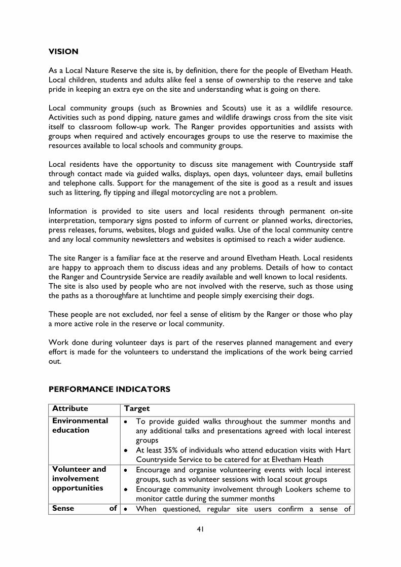
As a Local Nature Reserve the site is, by definition, there for the people of Elvetham Heath.
Local children, students and adults alike feel a sense of ownership to the reserve and take
pride in keeping an extra eye on the site and understanding what is going on there.
Local community groups (such as Brownies and Scouts) use it as a wildlife resource.
Activities such as pond dipping, nature games and wildlife drawings cross from the site visit
itself to classroom follow-up work. The Ranger provides opportunities and assists with
groups when required and actively encourages groups to use the reserve to maximise the
resources available to local schools and community groups.
Local residents have the opportunity to discuss site management with Countryside staff
through contact made via guided walks, displays, open days, volunteer days, email bulletins
and telephone calls. Support for the management of the site is good as a result and issues
such as littering, fly tipping and illegal motorcycling are not a problem.
Information is provided to site users and local residents through permanent on-site
interpretation, temporary signs posted to inform of current or planned works, directories,
press releases, forums, websites, blogs and guided walks. Use of the local community centre
and any local community newsletters and websites is optimised to reach a wider audience.
The site Ranger is a familiar face at the reserve and around Elvetham Heath. Local residents
are happy to approach them to discuss ideas and any problems. Details of how to contact
the Ranger and Countryside Service are readily available and well known to local residents.
The site is also used by people who are not involved with the reserve, such as those using
the paths as a thoroughfare at lunchtime and people simply exercising their dogs.
These people are not excluded, nor feel a sense of elitism by the Ranger or those who play
a more active role in the reserve or local community.
Work done during volunteer days is part of the reserves planned management and every
effort is made for the volunteers to understand the implications of the work being carried
out.
PERFORMANCE INDICATORS
Attribute Target
Environmental
education To provide guided walks throughout the summer months and
any additional talks and presentations agreed with local interest
groups
At least 35% of individuals who attend education visits with Hart Countryside Service to be catered for at Elvetham Heath
Volunteer and
involvement
opportunities
Encourage and organise volunteering events with local interest
groups, such as volunteer sessions with local scout groups
Encourage community involvement through Lookers scheme to monitor cattle during the summer months
Sense of When questioned, regular site users confirm a sense of

42
ownership ownership and fondness for the site and its wildlife
When questioned, regular site users demonstrate knowledge of
the reserves wildlife, past or planned management and its
rationale
MANAGEMENT
Management
Options Notes on Management Tasks Time and Resources
Environmental
Education
Organise / carry out a minimum of two
guided walks onsite as part of HDC‟s
Countryside Service guided walks
programme.
Organise / carry out one to two
additional educational
walks/talks/presentations to organisations
on request.
Preparation time depends
on event (approx 0.5
days per event) (Each
walk lasts 1.5-2 hrs)
As and When Required
Rangers / Specialist
Volunteering
Provide / facilitate volunteering
opportunities as and when they arise for
schools, local interest groups, regular
volunteers & corporate groups.
Recruit / maintain close links with lookers
and provide training for new lookers.
As and when Required
(when resources allow)
As and when Required
Sense of
Ownership /
Community
Encourage / cultivate a sense of
ownership for the site through up to date
information: websites, blogs, forums,
publications, press releases, and onsite
posters.
As and when Required
(pre & post management/
event/ activity What to
see posters 2-3 annually,
incident information
appeals, guided walks
once yearly etc)
A Safe
Community
Liaise / communicate with emergency
service, community groups and local
residents regarding antisocial behaviour,
including arson.
Report serious incidents to police and
minor incidents to 101 reports.
Site visit with local PCSO
minimum twice yearly as
and when incidents occur
MONITORING
Monitoring can be through local forums, blogs, emails, calls, incident reports, feedback from
neighbourhood watch and other community meetings. Collecting information on site usage
– school groups, volunteer activities, illegal site usage, and dog bins etc. Site user
questionnaires – five yearly (see Appendix 2).

43
Feature 7 – Access
As a fairly new development, Elvetham Village enjoys a comprehensive footpath and cycle
path network. These link the various
target areas of Elvetham Village shops and
recreational areas, Fleet Town, the
Business Park at Ancells Farm and
ultimately, Fleet Town Train Station and
Bus Terminal. The Nature Reserve and
Open Space are ideally placed so that
walkers and cyclists can visit them or any
of the other aforementioned areas with
the minimum of interruption by roads
and other built-up areas, if they so wish.
The standard of construction for the various pathways is high and appropriate
to the functions they perform. Gates and inclines are designed to be sympathetic to the
needs of wheelchairs and buggies. A variety of visual stimulus‟s and travelling distances can
be experienced. The open space surrounding the nature reserve contains a network of
formalized gravel paths and a cycle track runs through the centre of the site. Within the
nature reserve there are gravel pathways with raised boardwalks over the wet areas in a
non-circular route. All the boardwalks are fitted with anti-slip mesh to improve the safety
of these structures for the public. Self-
closing kissing gates allow access into the
reserve, which are suitable for
wheelchairs, pushchairs and bicycles. Each
kissing gate has a rope pull for trained
„helper‟ dogs for people using wheelchairs.
The dogs pull a rope to open and close
the gates whilst the person in a chair
manoeuvres through the gate. Limited
parking spaces are available in Mounts
Way and Reynolds Street, with most
visitors encouraged to use the
comprehensive cycle paths and walkways.
Current use is predominantly by local
people (from both Elvetham Heath and the
wider Hart area) taking exercise with or without their dogs, young parents out with
children during the working day and local workers using the reserve during lunch breaks
either for a walk or as a thoroughfare to the local supermarket. The site is also used during
warmer months for school and community groups and guided walks, and during winter
months for volunteer working days.
Although public transport is available nearby from local buses, national rail services previous questionnaires indicate that visitors do not appear to access the reserve in this way at
present. There is a footbridge linking Elvetham Heath across the railway line to Elvetham
Road that opened in 2005, this may increase visitors from the local rail link.
Figure 11: Cycle path
Figure 12: Boardwalk southern section of Nature Reserve

44
There are three main notice boards at the main entrances to the Nature Reserve (by the
main pond and Elvetham Way). Each map indicates your position with „you are here‟ signs.
The access, location and layout of the reserve does not make it particularly appealing for
visitors on horseback and the wet nature of the site would also detract from the ability to
use off-path areas on a horse. Using the reserve for off-road motorised cycles may be an
attraction for local owners of such machines, however, the damaging effects on the integrity
of the pathways and the off-path areas are undesirable from both an access
provision/maintenance and a nature conservation point of view, and so are discouraged.
With all forms of use of the reserve, the high water levels at the site do not make it suitable
for heavy use away from the provided pathways. The mobility of the ground and the infancy
of the ground flora will suffer greatly from damaging activities and therefore the most
suitable access option for the site is to allow open access for quiet enjoyment and
controlled activities.
This is defined by allowing use of the pathways on foot and bicycle. Off-path use is
permissive only and should be kept to a minimum, particularly by bicycles. Dogs should be
kept under strict control at all times, this means that a dog can be off the lead but its owner
should remain in control of the dog at all times, and therefore should be able to recall the
dog at any time. Any dog that can not be recalled at any time should be kept on a lead.
When livestock are present on site, all dogs should be kept on a lead at least in the vicinity
of the livestock.
Any trees that are deemed dead, dying or dangerous that are in high target areas will be
removed as soon as is reasonably practical. In addition tree inspection surveys are carried
out annually in accordance with Hart District Councils Tree Safety Policy.
OBJECTIVES
1. To create and maintain an enjoyable and safe amenity for the local community.
2. To maintain and enhance access within the nature reserve and surrounding open
spaces
3. To prevent and reduce impact from misuse of the site, i.e. fly-tipping, vandalism,
illegal motorbike use and other anti-social behaviour.
PERFORMANCE INDICATORS
Attribute Target
Site usage
No upper limit (i.e. 100% of site use is for passive, informal recreation)
Minimise illegal and prohibited activities on site as far as
possible (i.e. 0% of illegal activities)

45
Accessibility
Pathways, boardwalks and access points to be accessible 365
days of the year
Access provision only unsatisfactory when there are
overriding reasons of Health and Safety
No more than 10% of site users to encounter difficulties with accessibility
Access levels
compatible with
the nature
conservation
objectives
Nature conservation features not adversely affected – levels undetermined. Record to determine future limits/actions
Access levels do not hinder progress to favourable
conservation status
VISION
Access to the nature reserve is both easy and diverse. Links to the reserve from the
surrounding area and access into the site itself allows for a variety of visitors to use the reserve in a trouble free manner. The reserve is free of litter with a minimum of dog waste.
Detrimental access leading to damaging activities does not occur and so other site access is
not affected by such activities. Vistas are kept open allowing site users to feel safe and
secure whilst enjoying the site.
Access for quiet enjoyment and controlled activities is encouraged. Visitors do not stray
from the path unduly and dogs are kept under strict control at all times. Livestock grazing,
as part of the management of the nature conservation features, does not impede access for
visitors to the detriment of their enjoyment of the nature reserve and in many cases
enhances their enjoyment.
Access into the reserve by motorised vehicles is permitted only for the good of the
reserves management projects, fire fighting and access to the pumping station and statutory
easements (drainage and electricity way leave). All essential vehicle access is managed to
have minimal impact on the access provisions at the reserve.
MANAGEMENT
Management
Options Notes on Management Tasks
Time and
Resources
Dog fouling and
littering
Dog fouling and littering will adversely affect
the site features, poses a threat to human
health and spoils people‟s enjoyment of the
site.
Attempts to control this can be made by
maintaining and where appropriate replacing
litter bins and dog mess bins and actively
encouraging visitors to use them. Free dog
waste bags may be made available to site users.
Posters urging owners to act responsibly,
Monitoring of dog
fouling, littering
and bins
As and When
Required
Ranger / Waste
and Street Cleaning
contractor
Interpretation
As and When

46
leaflets or blogs, forum articles and
information flyers about the dangers of dog
mess, press releases and fining offenders can
help to tackle this problem. The nature
reserve to be litter picked once a week.
Required
Rangers
Litter picked once
weekly by rangers
Infrastructure
Footpaths, boardwalks, bridges and kissing
gates should be maintained to a high standard
and repaired or replaced when necessary.
Infrastructure inspections should be carried
out annually in accordance with HDCs
Countryside Service Health & Safety Policy.
The site budget is limited for minor structural
repairs. Funding may have to be bid for /
applied for if large projects are carried out or
if expensive items need repair or replacement.
Maintenance &
Repairs
As and When
Required
Rangers /
Contractors
Inspection 1 day /
yr
Rangers
Statutory
Service Easements
Statutory services have the legal right to enter
onto the site. Thames Water and Scottish &
Southern Electric (the companies in ownership
of the services at the time of writing this plan)
have company padlocks on the main gates into
the reserve. These companies can enter onto
the site to access their services at any time if
carrying out emergency work or within 24
hours, upon serving notice on the Council for
planned maintenance works.
In practice, written notification is not always
presented and contractors may enter on site
uncontrolled at any time in some
circumstances. Therefore steps should be
taken to contact the regional supervisor to
find out when and what works may be planned for the nature reserve.
Access to the overhead power lines is not
provided in a permanent structured way as
with the pumping station. No road or paths
exist to gain access to this area which is
extremely wet and inaccessible to machinery
or vehicles. Where and when statutory access
is required care must be taken to either
maintain the lines or clear vegetation from
beneath the line. Close liaison with
contractors and regional supervisors is
essential to minimise the impact on the
reserve and the access provision for site users.
The porous paving road way through the
Communication
with Statutory
Services
As and When Required
Rangers
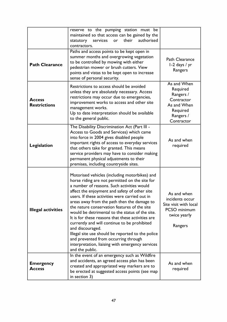
47
reserve to the pumping station must be
maintained so that access can be gained by the
statutory services or their authorised
contractors.
Path Clearance
Paths and access points to be kept open in
summer months and overgrowing vegetation to be controlled by mowing with either
pedestrian mower or brush cutters. View
points and vistas to be kept open to increase
sense of personal security.
Path Clearance
1-2 days / yr
Rangers
Access
Restrictions
Restrictions to access should be avoided
unless they are absolutely necessary. Access
restrictions may occur due to emergencies,
improvement works to access and other site
management works. Up to date interpretation should be available
to the general public.
As and When
Required
Rangers /
Contractor
As and When
Required Rangers /
Contractor
Legislation
The Disability Discrimination Act (Part III -
Access to Goods and Services) which came
into force in 2004 gives disabled people
important rights of access to everyday services
that others take for granted. This means
service providers may have to consider making
permanent physical adjustments to their
premises, including countryside sites.
As and when
required
Illegal activities
Motorised vehicles (including motorbikes) and
horse riding are not permitted on the site for
a number of reasons. Such activities would
affect the enjoyment and safety of other site
users. If these activities were carried out in
areas away from the path then the damage to
the nature conservation features of the site
would be detrimental to the status of the site.
It is for these reasons that these activities are currently and will continue to be prohibited
and discouraged.
Illegal site use should be reported to the police
and prevented from occurring through
interpretation, liaising with emergency services
and the public.
As and when
incidents occur
Site visit with local
PCSO minimum
twice yearly
Rangers
Emergency
Access
In the event of an emergency such as Wildfire
and accidents, an agreed access plan has been
created and appropriated way markers are to
be erected at suggested access points (see map in section 3)
As and when
required

48
MONITORING
Annual tree safety assessments
Annual infrastructure safety inspections
Five yearly site questionnaires

49
Feature 8 – Interpretation
There is a variety of signage throughout the site which is used to inform and interpret
information to visitors to ensure they get the most out of their visit.
The information signs include
„Welcome‟ boards, these are simple
boards made of oak and positioned at
three key entrance points to the site
to indicate that the visitor is entering
the Elvetham Heath Nature Reserve
and Open Spaces.
Interpretation panels are positioned at
key entrance points to the nature
reserve. They are of solid construction, and comprise of steel
frames, glass reinforced plastic artwork
panels and lockable notice boards.
These panels provide directional signs,
site maps, text and artwork, which
enable the visitor to understand the facts of the site. Lockable notice boards inform
members of the public on up and coming events, what to see this month (specific wildlife)
talks and walks. Three additional notice boards are situated at minor access points to the
nature reserve.
Several other forms of media are utilized, these include regular press releases to the local
media; which includes local newspapers, the Fleet News and Mail and the Star Courier. In
addition to local media the site ranger also contributes seasonal information about the
nature reserve to the Elvetham Heath newsletter local directories and the Council‟s in
house publication “Hart News”.
With the help of the site ranger the
Marketing Officer designs and writes
the copy for a number of publications
which are distributed to local council
run facilities and community buildings.
The council‟s website is used to display
a range of information about the site
such as its history, management plan
and general site information. The
website is also used to present a
Rangers Blog, which is updated
regularly with seasonal information about
the site as well as to promote community involvement, the guided walks and habitat management. The Rangers Blog information is
also passed to the Press Officer for publication in the Hart Life e-zine, which is a new web
based publication that‟s produced every month and the Hart News.
Figure 13: Interpretation panel with lockable
notice board
Figure 14: Welcome sign at St Swithins Road
entrance

50
When opportunities arise, rangers attend exhibitions or events to promote all the
countryside sites, habitat management, conservation and responsible dog ownership to the
residents of the Hart District. The site rangers in conjunction with the Marketing Officer
produce exhibition literature and posters.
Guided walks are carried out every year and include information on the natural history of
the site. Everyone is welcome and the majority of walks are suitable for wheelchair users or
members of the public with buggies.
OBJECTIVES
To provide and maintain permanent and temporary interpretation for all visitors to the site
VISION
Interpretation at the site will significantly enhance the quality of visitors‟ experience, along with their awareness and understanding of the site and its features. Visitors will be aware of
any site hazards and take steps to minimise that risk upon themselves.
The interpretation will be sufficient and suitable so that any damaging impacts, caused by
visitors, on the nature conservation features, or other features of interest, is minimised.
Visitors will also have a good understanding of management works and plans of the nature
reserve, through both permanent and temporary interpretation provisions.
Visitors will be very aware that Hart Countryside Service, a part of Hart District Council,
manages the site, and that there is a dedicated site Ranger that they can contact regarding
anything to do with the reserve. Contact details will be readily available to site users.
PERFORMANCE INDICATORS
Attribute Target
Awareness
(through
interpretation)
90% of visitors to be aware of the nature conservation features
and how their activities may be damaging, such as trampling,
littering, dog fouling and flytipping
95% of visitors to leave with a better understanding of the importance of the nature conservation features and other
features of interest, management works and the need to protect
the features
All visitors to be aware of site hazards and the actions that they
must take to minimise risk
All visitors to know that Hart Countryside Service manages the nature reserve and that there is a site Ranger they can contact
regarding the reserve. Details of how to contact the Service and
Ranger are clear and easy to find

51
MANAGEMENT
Management
Options Notes on Management Tasks
Time and
Resources
Permanent
Interpretation
Panels
The current interpretation structures are of
good quality and are structurally sound, providing they are not vandalised or
destroyed. Steps should be taken to ensure
this does not happen. Replace, maintain and
repair display, welcome and notice boards
when necessary.
As and when Required
Rangers / Contractor
Temporary
Interpretation
Interpretation should be up to date and relevant to the time of year and include up
and coming activities, events, management
and incidents that have occurred. All suitable
media should be utilized, including relevant
websites, blogs, forums, publications, press
releases, and onsite posters.
As and when Required management/ event/
activity / what to see
posters 2-3 annually,
incident appeals,
warning signs, guided
walks

52
Section 3: Action Plan
1. Introduction
The Action Plan sets out management tasks by feature for the next five years. The
total amount of work needed may not be finished in these five years, but at the end of
this time a review of the work should be completed and the Management Plan
updated. The Action Plan acts as a guide for management tasks and should be flexible
if necessary.
A/W- As and when required or requested

53
Years
Feature 1: Heathland and wet heath/mire 2011 2012 2013 2014 2015 Additional Notes
Grazing √ √ √ √ √ 2-4 cows, Apr-Oct
Scrub clearance A/W A/W A/W A/W A/W Sep- Mar
Mowing of old heather A/W A/W A/W A/W A/W Small patches, Oct- Feb
Heather Spreading A/W A/W A/W A/W A/W
Scraping √ √ √ Shallow pools & Dry scrapes, Sep- Feb
Bracken control (spraying) A/W A/W A/W A/W A/W Apr- July
Rhododendron control (spraying) A/W A/W A/W A/W A/W Apr- July
Rhododendron control (cutting) A/W A/W A/W A/W A/W Sep- Mar
Manage dangerous trees √ √ √ √ √ In line with Tree Safety Policy
Fire break maintenance √ √ √ √ When needs arise
Feature 2: Native wet woodland 2011 2012 2013 2014 2015 Additional Notes
Coppicing and pollarding √ √ Sep- Feb
Dead wood provision √ √ √ √ √ Sep- Feb
Glade creation √ Sep- Feb
Rhododendron control (spraying) A/W A/W A/W A/W A/W Apr- July
Rhododendron control (cutting) A/W A/W A/W A/W A/W Sep- Feb
Nest and roost site creation √ √ √ √ √ Sep- Mar
Manage dangerous trees A/W A/W A/W A/W A/W In line with Tree Safety Policy
Feature 3: Wooded/scrub perimeter buffer 2011 2012 2013 2014 2015 Additional Notes
Coppicing and pollarding √ Sep- Feb
Rhododendron control (spraying) A/W A/W A/W A/W A/W Apr- July
Rhododendron control (cutting) A/W A/W A/W A/W A/W Sep- Feb
Nest and roost site creation √ √ √ √ √ Sep- Mar
Manage dangerous trees A/W A/W A/W A/W A/W In line with Tree Safety Policy
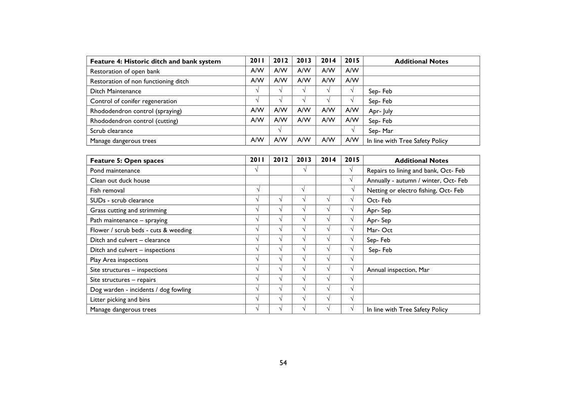
54
Feature 4: Historic ditch and bank system 2011 2012 2013 2014 2015 Additional Notes
Restoration of open bank A/W A/W A/W A/W A/W
Restoration of non functioning ditch A/W A/W A/W A/W A/W
Ditch Maintenance √ √ √ √ √ Sep- Feb
Control of conifer regeneration √ √ √ √ √ Sep- Feb
Rhododendron control (spraying) A/W A/W A/W A/W A/W Apr- July
Rhododendron control (cutting) A/W A/W A/W A/W A/W Sep- Feb
Scrub clearance √ √ Sep- Mar
Manage dangerous trees A/W A/W A/W A/W A/W In line with Tree Safety Policy
Feature 5: Open spaces 2011 2012 2013 2014 2015 Additional Notes
Pond maintenance √ √ √ Repairs to lining and bank, Oct- Feb
Clean out duck house √ Annually - autumn / winter, Oct- Feb
Fish removal √ √ √ Netting or electro fishing, Oct- Feb
SUDs - scrub clearance √ √ √ √ √ Oct- Feb
Grass cutting and strimming √ √ √ √ √ Apr- Sep
Path maintenance – spraying √ √ √ √ √ Apr- Sep
Flower / scrub beds - cuts & weeding √ √ √ √ √ Mar- Oct
Ditch and culvert – clearance √ √ √ √ √ Sep- Feb
Ditch and culvert – inspections √ √ √ √ √ Sep- Feb
Play Area inspections √ √ √ √ √
Site structures – inspections √ √ √ √ √ Annual inspection, Mar
Site structures – repairs √ √ √ √ √
Dog warden - incidents / dog fowling √ √ √ √ √
Litter picking and bins √ √ √ √ √
Manage dangerous trees √ √ √ √ √ In line with Tree Safety Policy

55
Feature 6: The local community 2011 2012 2013 2014 2015 Additional Notes
Guided walks √ √ √ √ √ Jun- Oct
Talks and presentations √ √ √ √ √
Education groups √ √ √ √ √
Community events √ √ √ √ √
Volunteer days √ √ √ √ √ Oct- Mar
Voluntary warden -cattle √ √ √ √ √ May- Oct
Local volunteer positions √ √ √ √ √
Written / visual communication √ √ √ √ √ Press releases, articles, blogs
On site information √ √ √ √ √
High profile within the community √ √ √ √ √
Liaise with emergency services √ √ √ √ √
Site visit with local PCSO √ √ √ √ √ 1-2 times annually
Litter pick √ √ √ √ √
Site patrols √ √ √ √ √ Apr-Oct:1/wk Nov-Mar: fortnightly
Maintain dog / refuse bins √ √ √ √ √
Feature 7: Access 2011 2012 2013 2014 2015 Additional Notes
Inspect pathway and boardwalks √ √ √ √ √
Maintain pathways and boardwalks A/W A/W A/W A/W A/W
Maintain gates A/W A/W A/W A/W A/W
Clear paths of vegetation √ √ √ √ √ May- Sep
Maintain provision dog bins √ √ √ √ √
Manage statutory service access √ √ √ √ √
Maintain vehicular access to pumping station √ √ √ √ √
Maintain access for emergency services √ √ √ √ √
Survey tree health near pathways √ √ √ √ √ In line with Tree Safety Policy
Manage dangerous trees A/W A/W A/W A/W A/W In line with Tree Safety Policy
Promote the site as being 'access friendly' √ √ √ √ √
To provide information to interested parties A/W A/W A/W A/W A/W

56
Feature 8: Interpretation 2011 2012 2013 2014 2015 Additional Notes
Inspect interpretation √ √ √ √ √
Maintain permanent interpretation A/W A/W A/W A/W A/W
Provide temporary interpretation √ √ √ √ √
Maintain corporate approach to interpretation √ √ √ √ √
Renew permanent interpretation √
Monitoring Projects 2011 2012 2013 2014 2015 Additional Notes
Fixed point photography √ √ √ √ √ Annual, July & Aug
Vegetation survey √ Chris Hall, May- Sep
Entomological survey √ Mike Edwards, May- Sep
Status assessments √ √ √ √ √ Annual, Apr- Sep
Follow up inspection of management work √ √ √ √ √
Advice from expert / knowledgeable sources A/W A/W A/W A/W A/W
Informal inspections √ √ √ √ √
Species sightings √ √ √ √ √
Nest / roost box checks & clean out √ √ √ √ √ Sep - Nov
Hazard tree surveying √ √ √ √ √ May- Aug
Site user questionnaires √ May- Aug
Site diary - all information √ √ √ √ √ incidents, education, volunteering
Site patrolling √ √ √ √ √

57
2. Work Plan Maps
MAP 8 - Turf Scrapes

58
MAP 9 - Bracken Control

59
MAP 10 - Rhododendron & Goats Rue Control

60
MAP 11- Fire Control with use of Fire Breaks

61
MAP 12 - Emergency Access

62
SECTION 4 - SUSTAINABILITY AND MARKETING
1. A welcoming place
It is a key priority in the Hart District Council Corporate Objectives to enhance the
environment by:
„ensuring a clean, green and safe environment by maintaining and enhancing a high quality,
sustainable environment for the people who live in, work in, or visit the District.‟
Hart District Council is committed to helping its residents achieve a healthy body and mind
by providing a variety of leisure facilities for all ages to enjoy. As part of the service we also
provide for the conservation of the local environment and manage and maintain many
countryside sites throughout the district. The service also provides and maintains parks and
play areas around the district and works in partnership with other providers to make the
best of current opportunities. Elvetham Heath is a key site in this district strategy.
2. Sustainability
2.1 Sustainable Urban Drainage Systems (SUDS)
SUDS are management practices and physical structures that are designed and built to
attenuate surface water in a more sustainable way than conventional drainage systems.
Significant developments are likely to increase the total area of impervious surfaces due to
roofs, roads car parks etc. This interferes with the natural hydrological cycle and increases
the drainage requirements over those that were prior to development taking place. SUDS
act to manage surface water drainage and consequently help reduce flood risk areas; they
can also make use of sedimentation, filtration and other natural processes in an attempt to
reduce levels of pollutants being discharged into watercourses.
There are different methods of control, which can be integrated, they are:
Filter strips and swales
Filter drains and permeable surfaces
Infiltration devices
Basins, ponds and wetlands
Ultimately, the provision of SUDS at Elvetham will enhance the local biodiversity whilst
providing a sustainable method in managing flooding and the affects of pollution.
2.2 Carbon Footprint
The council is committed to issue on climate change and has produced a Strategy on
Climate Change which is measured against National Performance Indicators;

63
NI185 on energy use and carbon foot print, and
NI186 climate change issues
Following is an example of this practice in implementation on Elvetham Heath.
Timber from tree felling for heathland restoration is utilized by local companies, the
majority of the timber has been sent to a wood burning power station. These stations save
thousands of tonnes of co² emissions each year compared to fossil fuel burning, a positive
step forward in the fight for climate change. A large proportion of timber has also been sent
to a local company which chips it into bedding for horse stables. A reputably local
contractor was employed to carry out the above work; this contractor routinely utilizes
timber for Power Stations and as woodchip for Horticulture and animal husbandry.
2.3 Partnership Working
The opportunity for exploring partnership working is a requirement of a modern thinking
and efficient service provider. Training is given by the council to give Managers the
appropriate knowledge to make the best use of opportunities arising from partnership
working.
Partners can arise from familiar or unusual areas; volunteers are a normal partnership area
used. The cattle “Lookers” are a prime example of this. More unusual are the local
internet forums which help with advertising walks and talks, but also give a more honest
insight of how well we are doing around issues that are important to the local community.
A partnership is also developing between the council and the new parish of Elvetham. This
will put joint responsibility on delivering resources along the estate as well as the site in
delivering this management plan.
Timber removal for horse bedding – May 2009

64
3. Marketing Strategy
3.1 Current Marketing Activity
The marketing activity for EHNR is undertaken by the Council‟s Marketing Officer in
conjunction with the Grounds and Countryside manager and the site ranger.
The main marketing activities undertaken are:
Public Relations
This is managed by the Marketing Officer who deals with media enquires and distributes
press releases to the local media; which includes local newspapers, The Fleet News and Mail
and the Star Courier. In addition to local media the site ranger also contributes seasonal
information about the Nature reserve to the Elvetham Heath newsletter, the Council‟s in
house publication the Hart News which is distributed to every household in the district
twice a year and the Council‟s online newsletter Hart life which is available monthly.
Brochures and Leaflets
With the help of the site ranger the Marketing Officer designs and writes the copy for a
number of publications which are distributed to local council run facilities and community buildings.
Published material includes:
Great Outdoors brochure
Guided Walks brochure
Volunteer recruitment leaflets
Paid for Advertising
The Marketing Officer copy writes and designs adverts for a variety of local media such as;
newspapers, directories and parish magazines and newsletters. The adverts are used to
promote volunteering and the calendar of guided walks.
Printed Material
Habitat management, site works and responsible dog ownership are promoted by on site
posters which are designed and distributed by the site ranger.

65
E Marketing
The council‟s website is used to display a range of information about the site such as its
history, management plan and general site information. The website is also used to present a
Rangers Blog, which is updated regularly with seasonal information about the site as well as
promote community involvement, the guided walks and habitat management. The Rangers
Blog information is also passed to the Press Officer for publication in Hart life and Hart
News.
Internal Communication
The Marketing Officer informs staff and councillors about any significant information about
the site via the Council‟s intranet or via email.
Signs
The copy and the design of the signage throughout the site were done by the site ranger
and the Marketing Officer in keeping with the corporate identity.
Exhibitions
All the rangers attend a number of exhibitions throughout the year to promote all the
countryside sites, habitat management, conservation and responsible dog ownership to the
residents of the Hart District. The site rangers in conjunction with the Marketing Officer
produce exhibition literature and posters.
These activities will continue and run alongside the new objectives which are listed below.
Increase the number of corporate volunteers
Increase the number of special interest group volunteers
Increase the nature reserves profile in local publications and online forums
Develop a market research programme
Introduce a booking system for some walks
3.2 Strategy
This strategy will focus on the Countryside departments‟ resources and the course of action
which will lead to the completion of the above objectives.
3.3 Corporate volunteers
Corporate volunteering provides local companies with a clear way to demonstrate their
commitment to helping the local community in which they operate. Since 2009 the EHNR
ranger has organised 5 corporate volunteer days in which a total of 72 people attended.
In order to increase the number of corporate volunteer days the Marketing Officer will
need to actively promote the benefits of volunteering to the business community. This will
be done by copying writing and designing a Corporate Volunteer pack which will be sent to
local businesses and available on the council‟s website.

66
To establish an address list of local businesses the Leisure and Environmental Promotion
support team firstly research which companies in the district have a CSR policy, then
contact them to see if they would like to take part. A newsletter will also be sent out to the
local business forum to inform them of the benefits of volunteering and some contact details
should they wish to do so.
So that local companies continue to volunteer on a regular basis a database will be set up to
capture their details so that they can be sent a newsletter on a quarterly basis via post or
email advertising the sort of work they could get involved with next season as well as
information on the guided walks.
3.4 Special interest group volunteers
Like corporate volunteering, time given by special interest groups is invaluable to the HDC
countryside service. Since 2009 the EHNR ranger organised three separate volunteer days
with two local scout groups.
In order to increase these volunteer days a mailing list of special interest groups will be set
up by the Marketing Officer which will include groups such as girl guides, scouts, local
colleges, charities, nature societies, churches and any other relevant organisations. They will
first be called and asked if they would like to receive a pack on volunteering at the site and
how it could benefit them.
Once this has been sent out it will be followed up with a quarterly newsletter via post or
email which will advertise any work that could be of interest to them in the coming season
as well as the sites guided walks.
3.5 Elvetham Heath profile
By increasing the presence of the nature reserve in local publications and online forums it
will give the site ranger another channel through which to promote various pieces of
information about the site. These will include listings of the guided walks, information on
local wildlife and site management, details of conservation projects, and handy hints about
littering and responsible dog ownership.
The Marketing Officer will aim to set up a quarterly Countryside feature in some of the
local directories that will take the form of a diary entry from the site ranger. The article will
include a picture of the site ranger, information about the site and a variety of photographs
showing any works being carried out as well as attractive scenic ones. This should help the
public begin to identify with the ranger and the work they do as well as create a sense of
responsible ownership and possibly encourage volunteering.
3.6 Market research programme
By developing a market research programme the Environmental Promotion team will be
able to further discover what local people want or need from the site. It will also give the
Marketing Officer the opportunity to measure how effective any paid for advertising has
been and how the site should be marketed in the future.

67
The research programme will begin with the Marketing Officer developing a questionnaire
with the site ranger that can be distributed to local people twice a year. This will be done in
a variety of ways, one will be via a „questionnaire drop‟ to the surrounding housing
development with a SAE for ease of return, through the council website and citizens panel,
through face to face surveys by the site ranger and via the local directories.
A market research programme will also be developed to gather feedback from those who
have volunteered or attended a guided walk. From previous experience it has been noted
that it is difficult to gather information from people during the guided walks or while they
are volunteering therefore the mailing list that will be created and will be used not only to
inform people of new walks or volunteering opportunities but also as a way of sending out
questionnaires with a SAE to gather feedback about their experience.
Please see Appendix 2 for a summary of results from the 2010 questionnaire.
3.7 Booking system
By developing a booking system for some of the more specialised countryside walks it gives
the site ranger the opportunity to distribute their resources more efficiently.
It is also an opportunity to begin to develop a mailing list of individuals who are interested in
guided walks so they can be targeted with information when new brochures or leaflets are
published.
3.8 Resources
Men. All the above objectives will be met with the skills and expertises of the staff within
the Leisure and Environmental Promotion team except for the design and print of any
brochure and promotional leaflet, which will be outsourced.
Money. The service has a budget of £6,200 for marketing which will cover the cost of:
Brochure and leaflet print and design
Advertising space
Postage for questionnaires
3.9 Control
In order to measure the objectives that have been set out in section 3.1 the Marketing
Officer will need to set up some monitoring systems. A variety of spreadsheets will be set
up to record
the increase in volunteer numbers
the number of contacts on the new mailing lists
amount of press coverage & advertising space bought
results of twice yearly questionnaires

68
This information will then be used to review the service in order to modify and make
improvements to what is being provided.

69
SECTION 5 - BIBLIOGRAPHY Elvetham Heath Nature Reserve Management Plan, 2006 – 2011
Fleet Pond Management Plan, 2010 – 2015
An Entomological Survey of Elvetham Heath, Mike Edwards, 2007/8
A botanical Survey of Elvetham Heath, Chris Hall, 2006
British Plant Communities. Volume 2 Mires and Heaths. J.S. Rodwell
British Plant Communities. Volume 1 Woodlands and Scrub. J.S. Rodwell
Lowland heathland SSSIs: guidance on conservation objective setting and condition monitoring. English Nature Research Reports No. 511
The lowland heathland management handbook. English Nature Science No 8. English
Nature
The Wild Flower Key. Francis Rose
Heathland Harvest. Chris Howkins
Heathers and Heathland. Chris Howkins
Heathland. James Parry
www.bbc.co.uk
www.blackwater-valley.org.uk
www.defra.gov.uk
www.elvethamheath.co.uk
www.elvethamheathforum.info
www.naturalengland.org.uk
www.forestry.gov.uk
www.getamap.ordnancesurvey.co.uk
www.google.co.uk
www.hampshirebiodiversity.org.uk
www.hart.gov.uk
www.herpconstrust.org.uk
www.jncc.gov.uk
www.multimap.com
www.nbn.org.uk
www.rspb.org
www.ukbap.org.uk

70
SECTION 6: APPENDICES
APENDIX 1: SPECIES LISTS
Rare and Notable Habitats and Plants
Habitat/Species Designation/Conservation
Status
Location
Lowland Heathland Priority habitat under the UK Habitat Action Plan
(HAP) Rare and
threatened habitat
Nature Reserve
Purple moor grass and rush pastures
Priority habitat under
HAP
Nature Reserve
Wet woodland Priority habitat under
HAP
Nature Reserve
Gnaphalium sylvaticum
Heath Cudweed
Data Red List: Endangered Nature Reserve
Cuscuta epithymum Dodder
Data Red List: Vulnerable Nature Reserve
Filago vulgaris
Cudweed
Data Red List: Near
Threatened
Nature Reserve
Sustainable Urban Drainage
system (SUDs) & edge of
Turners Pond
Ulex minor
Dwarf gorse
National uncommon Nature Reserve
Droseria rotundifolia
Round-leaved Sundew
Regionally uncommon Nature Reserve
Drosera intermedia
Long-leaved Sundew
Regionally scarce Nature Reserve
Eleocharis multicaulis
Heath Spike rush
Regionally scarce Nature Reserve
SUDs
Carex pseudocyperus
Hop sedge
Regionally scarce Nature Reserve
Carex rostrata
Bottle sedge
Regionally scarce Nature Reserve
Eleogiton fluitans
Floating Club-rush
Regionally scarce Nature Reserve
SUDs
Myosotis secunda
Creeping Forget-me-not
Regionally scarce Nature Reserve
Myrica Gale
Bog Myrtle
Regionally scarce Nature Reserve

71
Rare and Notable Invertebrates
Habitat/Species Designation/Conservation
Status
Location
Stictopleurus punctatonervosus
Rhopalidae
Red Data Book (RDB)
RDB-app.
Southern Restricted
Nature Reserve
Gymnosoma rotundatum
Tachinidae
RDB 3
Southern Restricted
Nature Reserve
Tipula marginella
Tipulidae
RDB 3
Universal
Nature Reserve
Cryptocheilus notatus
Pompilidae
RDB 3
Southern Restricted
Nature Reserve
Gorytes laticinctus
Sphecidae
RDB 3
Southern Restricted
Nature Reserve
Hylaeus gibbus
Apidae
RDB 3
Southern Restricted
Nature Reserve
Agapanthia villosoviridescens
Cerambycidae
Nationally Scarce
Nature Reserve
Larinus planus
Curculionidae
Nationally Scarce Nature Reserve
Polydrusus formosus
Curculionidae
Nationally Scarce Nature Reserve
Ampedus elongantulus
Elateridae
Nationally Scarce Nature Reserve
Dasytes niger
Melyridae
Nationally Scarce Nature Reserve
Rhopalus maculates
Rhopalidae
Nationally Scarce Nature Reserve
Omocestus rufipes
Acrididae
Nationally Scarce Nature Reserve
Chrysis illigeri
Chrysididae
Nationally Scarce Nature Reserve
Ectemnius dives
Sphecidae
Nationally Scarce Nature Reserve
Nysson dimidiatus
Sphecidae
Nationally Scarce Nature Reserve
Nysson trimaculatus Nationally Scarce Nature Reserve
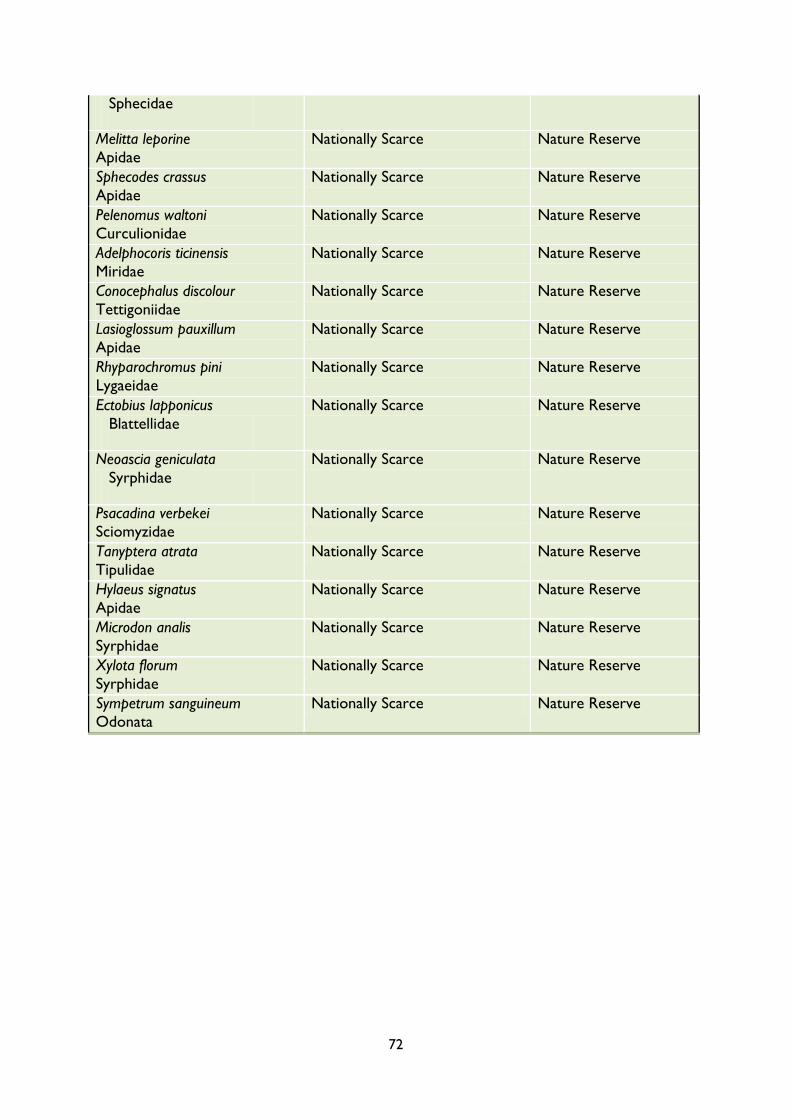
72
Sphecidae
Melitta leporine
Apidae
Nationally Scarce Nature Reserve
Sphecodes crassus
Apidae
Nationally Scarce Nature Reserve
Pelenomus waltoni
Curculionidae
Nationally Scarce Nature Reserve
Adelphocoris ticinensis
Miridae
Nationally Scarce Nature Reserve
Conocephalus discolour
Tettigoniidae
Nationally Scarce Nature Reserve
Lasioglossum pauxillum
Apidae
Nationally Scarce Nature Reserve
Rhyparochromus pini
Lygaeidae
Nationally Scarce Nature Reserve
Ectobius lapponicus
Blattellidae
Nationally Scarce Nature Reserve
Neoascia geniculata
Syrphidae
Nationally Scarce Nature Reserve
Psacadina verbekei
Sciomyzidae
Nationally Scarce Nature Reserve
Tanyptera atrata
Tipulidae
Nationally Scarce Nature Reserve
Hylaeus signatus
Apidae
Nationally Scarce Nature Reserve
Microdon analis
Syrphidae
Nationally Scarce Nature Reserve
Xylota florum
Syrphidae
Nationally Scarce Nature Reserve
Sympetrum sanguineum
Odonata
Nationally Scarce Nature Reserve

73
APPENDIX 2
SUMMARY OF QUESTIONNAIRE RESULTS

74
APPENDIX 3
FINANCIAL SUMMARY
INCOME
2010/ 2011
2011/ 2012
2012/ 2013
2013/ 2014
2014/ 2015
2015/ 2016
2016/ 2017
2017/ 2018
2018/ 2019
2019/ 2020
2020/ 2021
HLS - Funding £2,983 £2,983 £2,983 £2,983 £2,983 £2,983 £2,983 £2,983 £2,983 £2,983 £2,983
Walks & Talks £50 £50 £50 £50 £50 £50 £50 £50 £50 £50 £50
Section 106 £30,030 £30,030 £30,030 £30,030 £30,030 £30,030 £30,030 £30,030 £30,030 £30,030 £30,030
TOTAL INCOME £33063 £33063 £33063 £33063 £33063 £33063 £33063 £33063 £33063 £33063 £33063
EXPENDITURE
2010/ 2011
2011/ 2012
2012/ 2013
2013/ 2014
2014/ 2015
2015/ 2016
2016/ 2017
2017/ 2018
2018/ 2019
2019/ 2020
2020/ 2021
Employment Costs £37,000 £37,000 £37,000 £37,000 £37,000 £37,000 £37,000 £37,000 £37,000 £37,000 £37,000
Contract works £7,000 £18000 £2500 £2,500 £2,500 £2,500 £2,500 £2,500 £2,500 £2,500 £2,500
Dog bin emptying £1560 £1560 £1560 £1560 £1560 £1560 £1560 £1560 £1560 £1560 £1560
Grazing - - - £500 £500 £500 £500 £500 £500 £500 £500
Marketing & promotions £237 £260 £286 £315 £346 £381 £419
£461
£507
£558
£613
TOTAL
EXPENDITURE £45797 £56820 £41346 £41875 £41906 £41941 £41979
£42021
£42067
£42118
£42173


![MANAGEMENT PLAN 2011 - 2013 - RSPO KMS Management Plan 2011-2013.pdf · MANAGEMENT PLAN 2011 - 2013 [ 02 May 2011 ] Head Office Jalan Ir.H.Juanda 2, Block C No.1, Samarinda 75124](https://cdn.vdocuments.us/doc/165x107/5a8f792d7f8b9a4a268dbe62/management-plan-2011-2013-rspo-kms-management-plan-2011-2013pdfmanagement-plan.jpg)
