
Leica FlexLine TS09plusFull Precision at High Performance
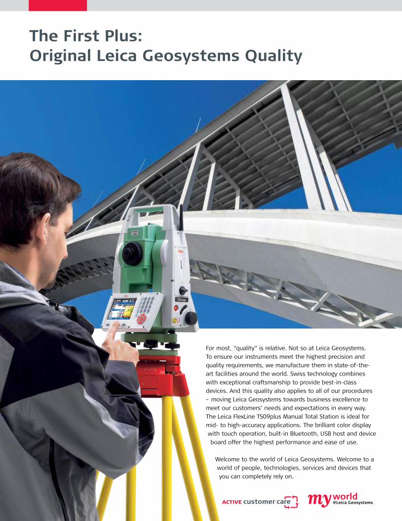
The First Plus: Original Leica Geosystems Quality
For most, “quality” is relative. Not so at Leica Geosystems. To ensure our instruments meet the highest precision and quality requirements, we manufacture them in state-of-the-art facilities around the world. Swiss technology combines with exceptional craftsmanship to provide best-in-class devices. And this quality also applies to all of our procedures – moving Leica Geosystems towards business excellence to meet our customers’ needs and expectations in every way.The Leica FlexLine TS09plus Manual Total Station is ideal for mid- to high-accuracy applications. The brilliant color display with touch operation, built-in Bluetooth, USB host and device board offer the highest performance and ease of use.
Welcome to the world of Leica Geosystems. Welcome to a world of people, technologies, services and devices that you can completely rely on.

The Third Plus: Full Precision, Superior Convenience and PerformanceElectronic Distance Measurement:Wherever high-distance measurement accuracy is required, you can face the challenge of this demanding task with the TS09plus. It provides the most accurate Electronic Distance Measurement.
Prism Mode � Precision+ (1.5 mm + 2 ppm) � Speed (1 second)
Non-Prism Mode � Precision (2 mm + 2 ppm) � PinPoint EDM with coaxial, small laser pointer and measurement beam for accurate aiming and measu-ring
� Fewer set-ups required, because targets on which it is not possible to set up a reflector can be measured using reflectorless measurement up to 1,000
Work productively with the new Leica FlexField plus on-board software and the new color & touch display.The new Leica FlexField plus software is without a doubt a highlight of the FlexLine plus. Its advantages are immediately apparent with the extra large, built-in color & touch display.
The Leica FlexLine TS09plus Communication Side Cover enables cable-free connection to any data collector via Bluetooth, for example the field-controllers Leica Viva CS10 or Leica Viva CS15 with SmartWorks Viva software. The USB-stick enables the flexible transfer of such data as GSI, DXF, ASCII, LandXML and CSV.
FlexField plus Onboard Software: Easy to use due to it’s graphical guidance and intuitive workflows.
� Low learning curve due to guided workflows � Easy to understand graphics and icons � Icons to quickly verify instrument status � Fast navigation inside the software via touch screen, tabs and icons
� High resolution color display to show all information without misinterpretation
� Larger font size for fast and clear readability � Fast operation through graphic guidance
Leica Geosystems – mySecurity mySecurity gives you total peace of mind. If your instrument is ever stolen, a locking mechanism is available to ensure that the device is disabled and can no longer be used.
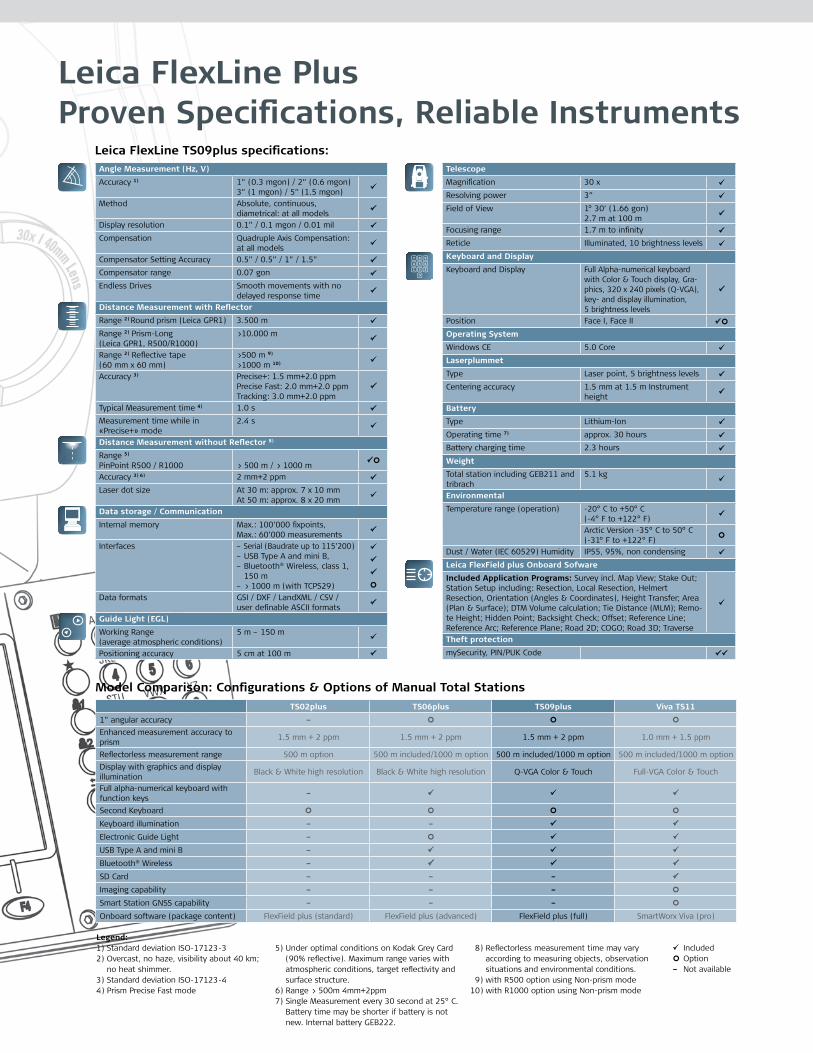
Leica FlexLine Plus Proven Specifications, Reliable Instruments
Leica FlexLine TS09plus specifications:
Legend:1) Standard deviation ISO-17123-32) Overcast, no haze, visibility about 40 km;
no heat shimmer.3) Standard deviation ISO-17123-44) Prism Precise Fast mode
5) Under optimal conditions on Kodak Grey Card
(90% reflective). Maximum range varies with atmospheric conditions, target reflectivity and surface structure.
6) Range > 500m 4mm+2ppm7) Single Measurement every 30 second at 25° C.
Battery time may be shorter if battery is not new. Internal battery GEB222.
8) Reflectorless measurement time may vary according to measuring objects, observation situations and environmental conditions.
9) with R500 option using Non-prism mode10) with R1000 option using Non-prism mode
IncludedOption–Not available
Model Comparison: Configurations & Options of Manual Total StationsTS02plus TS06plus TS09plus Viva TS11
1” angular accuracy –
Enhanced measurement accuracy to prism 1.5 mm + 2 ppm 1.5 mm + 2 ppm 1.5 mm + 2 ppm 1.0 mm + 1.5 ppm
Reflectorless measurement range 500 m option 500 m included/1000 m option 500 m included/1000 m option 500 m included/1000 m optionDisplay with graphics and display illumination Black & White high resolution Black & White high resolution Q-VGA Color & Touch Full-VGA Color & Touch
Full alpha-numerical keyboard with function keys –
Second Keyboard
Keyboard illumination – –
Electronic Guide Light –
USB Type A and mini B –
Bluetooth® Wireless –
SD Card – – –
Imaging capability – – –
Smart Station GNSS capability – – –
Onboard software (package content) FlexField plus (standard) FlexField plus (advanced) FlexField plus (full) SmartWorx Viva (pro)
Angle Measurement (Hz, V)
Accuracy 1) 1” (0.3 mgon) / 2” (0.6 mgon) 3” (1 mgon) / 5” (1.5 mgon)
Method Absolute, continuous, diametrical: at all models
Display resolution 0.1” / 0.1 mgon / 0.01 mil
Compensation Quadruple Axis Compensation: at all models
Compensator Setting Accuracy 0.5” / 0.5” / 1” / 1.5”
Compensator range 0.07 gon
Endless Drives Smooth movements with no delayed response time
Distance Measurement with Reflector
Range 2) Round prism (Leica GPR1) 3.500 m
Range 2) Prism-Long (Leica GPR1, R500/R1000)
>10.000 m
Range 2) Reflective tape (60 mm x 60 mm)
>500 m 9)
>1000 m 10)
Accuracy 3) Precise+: 1.5 mm+2.0 ppmPrecise Fast: 2.0 mm+2.0 ppmTracking: 3.0 mm+2.0 ppm
Typical Measurement time 4) 1.0 s
Measurement time while in «Precise+» mode
2.4 s
Distance Measurement without Reflector 8)
Range 5)
PinPoint R500 / R1000 > 500 m / > 1000 m
Accuracy 3) 6) 2 mm+2 ppm
Laser dot size At 30 m: approx. 7 x 10 mmAt 50 m: approx. 8 x 20 mm
Data storage / Communication
Internal memory Max.: 100’000 fixpoints, Max.: 60’000 measurements
Interfaces – Serial (Baudrate up to 115’200) – USB Type A and mini B, – Bluetooth® Wireless, class 1,
150 m – > 1000 m (with TCPS29)
Data formats GSI / DXF / LandXML / CSV / user definable ASCII formats
Guide Light (EGL)
Working Range (average atmospheric conditions)
5 m – 150 m
Positioning accuracy 5 cm at 100 m
Telescope
Magnification 30 x
Resolving power 3”
Field of View 1° 30’ (1.66 gon)2.7 m at 100 m
Focusing range 1.7 m to infinity
Reticle Illuminated, 10 brightness levels
Keyboard and Display
Keyboard and Display Full Alpha-numerical keyboard with Color & Touch display, Gra-phics, 320 x 240 pixels (Q-VGA), key- and display illumination, 5 brightness levels
Position Face I, Face II
Operating System
Windows CE 5.0 Core
Laserplummet
Type Laser point, 5 brightness levels
Centering accuracy 1.5 mm at 1.5 m Instrument height
Battery
Type Lithium-Ion
Operating time 7) approx. 30 hours
Battery charging time 2.3 hours
Weight
Total station including GEB211 and tribrach
5.1 kg
Environmental
Temperature range (operation) -20° C to +50° C (-4° F to +122° F)
Arctic Version -35° C to 50° C (-31° F to +122° F)
Dust / Water (IEC 60529) Humidity IP55, 95%, non condensing
Leica FlexField plus Onboard Sofware
Included Application Programs: Survey incl. Map View; Stake Out; Station Setup including: Resection, Local Resection, Helmert Resection, Orientation (Angles & Coordinates), Height Transfer; Area (Plan & Surface); DTM Volume calculation; Tie Distance (MLM); Remo-te Height; Hidden Point; Backsight Check; Offset; Reference Line; Reference Arc; Reference Plane; Road 2D; COGO; Road 3D; Traverse
Theft protection
mySecurity, PIN/PUK Code

USB Stick � For fast and easy transfer of data
Wireless Bluetooth
� For cable-free connection to data logger
Electronic Guide Light
� For faster stake-out
FlexField plus � Modern and intuitive on-board software for higher productivity
PinPoint EDM � The most precise in its class (1.5 mm + 2 ppm)
� Extremely fast (1 second) � > 1.000 meters without prism � Coaxial laser pointer and measurement beam
Color & Touch Display
� Highest user-friendliness
Useful tools � A range of tools, such as a trigger key and laser plummet, speed up your work
Arctic version � For use at –35°C (–31°F)
mySecurity � Unique cloud-based protection against theft
The Second Plus: Real Features, True Benefits

Leica Geosystems AG Heerbrugg, Switzerland
www.leica-geosystems.com
Whether you want to survey a parcel of land or objects on a construction site, determine measured points on facades or in rooms, gather the co-ordinates of a bridge or a tunnel – Leica Geosystems’ total stations pro-vide the right solution for every application. They unite reliable results with easy operation and user-friendly applica-tions. Our total stations are designed to meet your specific requirements. Modern technology enables you to work fast and productively, thanks to the straightforward and clearly structured range of functions.
– when it has to be right.
Please visit www.leica-geosystems.comfor detailed information about Leica FlexLine plus and more documents.
Total Quality Management – our commitment to total customer satisfaction.
Distance meter: (PinPoint R500 / R1000):Laser class 3R in accordance with IEC 60825-1 resp. EN 60825-1
Laser plummet:Laser class 2 in accordance with IEC 60825-1 resp. EN 60825-1
Distance meter: (Prism Mode)Laser class 1 in accordance with IEC 60825-1 resp. EN 60825-1
Guide light (EGL):LED class 1 in accordance with IEC 60825-1 resp. EN 60825-1
The Bluetooth® word mark and logos are owned by Bluetooth SIG, Inc. and any use of such marks by Leica Geosystems AG is under license.
Other trademark and trade names are those of their respective owners.
Cover picture: Shanghai Pudong Skyline
Illustrations, descriptions and technical data are not binding. All rights reserved. Printed in Switzerland – Copyright Leica Geosystems AG, Heerbrugg, Switzerland, 2013. 789508en-us – 06.15 – galledia
OriginalAccessoriesBrochure
Viva TS11Brochure
Original Accessories
Leica Geosystems Original ZubehörMaterial matters
FlexField plus &FlexOfficeBrochure
FlexLineTS06plusBrochure
FlexLineTS02plusBrochure
Leica FlexLine TS06plusTop Precision meets High Efficiency
Leica FlexLine TS02plusBest-In-Class Precision
Leica FlexField plus &Leica FlexOfficeA Perfect Match
Scan the codeto play
the videos!


