Land Use Technical Memorandum 1
MEMO
Date: Tuesday, August 01, 2017
Project: Cotton Belt Corridor Regional Rail; Land Use Existing Conditions
Technical Memorandum
To: John Hoppie, Project Manager, DART Capital Planning
From: Tom Shelton, GPC6 Program Manager
Subject: DART GPC VI, Cotton Belt Land Use Existing Conditions
Introduction: An assessment of the existing and future land use along the Dallas Area Rapid Transit
(DART)–owned Cotton Belt Corridor provides insight into development trends in the project study area.
Possible land use types include, but are not limited to, residential, office, light industrial, industrial,
commercial/retail, transportation, and institutional. Examining existing land use provides a sense of the
general character of the areas through which the alignment passes. Many cities have station area plans
to support future transit-oriented development (TOD) as well.
While the land use describes the function of a piece of property, zoning ordinances dictate the types of
permitted land uses and specific building requirements for a given piece of property or in a particular
district. Examining the existing zoning along the corridor provides an indication of current development
trends, as well as options for redevelopment and infill development in the future. Zoning includes
elements that may not be visually identified from an aerial or windshield survey, such as lot restrictions
and building height and footprint restrictions, among many other restrictions and requirements.
Regulatory Setting: Zoning ordinances approved by local municipal jurisdictions form the framework for
regulating land uses within city limits. The basis for this regulatory power at the local level comes from
Chapter 211, Municipal Zoning Authority, of the Texas Local Government Code.
Methodology: For the purposes of the environmental review, the project study area for land use
includes one-quarter mile on either side of the Cotton Belt Corridor and one-half mile radius around
each proposed station location. The most recent land use data from North Central Texas Council of
Governments (NCTCOG) (2015) was used for the existing land use. Municipalities were utilized as
primary sources for future land use plans and zoning.
Affected Environment: This section identifies existing land use, current development trends, municipal
future land use plans, and municipal policies regarding land use, zoning, and growth.
The project study area is shown in Figure 1.

Land Use Technical Memorandum 2
Figure 1
Cotton Belt Corridor Rail Study Area
Existing Corridor Land Use
The majority of the proposed Cotton Belt Project would follow the existing DART-owned Cotton Belt
railroad corridor, with some deviations. Since most development along the corridor occurred after the
existing rail corridor was constructed, several industrial and warehouse areas developed along the
corridor to have direct access to the rail for the transportation of goods. This history is apparent in the
many rail spurs that come off the main line to connect nearby businesses to the rail and in the many
existing industrial/warehouse uses adjacent to the alignment. Other primary existing land uses adjacent
to the Cotton Belt rail corridor include residential, commercial and mixed-use developments, and
undeveloped/park/open space. Figures 2 to 5 graphically depict the land use types within the corridor.
Table 1 shows the amount of each type of land use present in the corridor by acreage and percent of the
corridor.

Land Use Technical Memorandum 3

Land Use Technical Memorandum 4

Land Use Technical Memorandum 5

Land Use Technical Memorandum 6

Land Use Technical Memorandum 7
Source: NCTCOG 2015 Land Use Data
*“Corridor” in this table refers to the area within one-quarter mile of the alignment and a one-half mile radius around proposed
station locations.
Existing Station Area Land Use
The proposed Cotton Belt Project would primarily utilize existing freight right-of-way (Cotton Belt
Corridor), which passes through a variety of land uses, including undeveloped/agriculture, industrial,
Table 1
Cotton Belt Corridor Regional Rail Existing Land Use
Land Use Type Acres Within Corridor* Percent of Corridor
Vacant 1832.79 19.53
Industrial 1291.28 13.76
Single family 1242.73 13.24
Commercial 1204.71 12.84
Parks/recreation 965.45 10.29
Multi-family 784.00 8.35
Runway 318.78 3.40
Railroad 216.90 2.31
Airport 185.68 1.98
Institutional/semi-public 184.76 1.97
Education 174.21 1.86
Utilities 158.22 1.69
Transit 147.65 1.57
Group quarters 129.28 1.38
Retail 116.57 1.24
Water 79.95 0.85
Farmland 64.40 0.69
Small water bodies 54.54 0.58
Office 47.58 0.51
Hotel/motel 47.43 0.51
Ranch land 44.01 0.47
Under construction 35.14 0.37
Timberland 21.75 0.23
Cemeteries 13.66 0.15
Parking 10.34 0.11
Flood control 5.07 0.05
Residential acreage 4.01 0.04
Improved acreage 2.99 0.03
Communication 0.71 0.01
Mobile home 0.59 0.01
TOTAL 9,385.18 100.00%

Land Use Technical Memorandum 8
commercial, and residential. The proposed stations, however, are primarily located near or within well-
developed areas that serve as population and employment centers. This section describes land use around
each proposed station location. Table 2 shows predominant land use and local land use plans and policies
for each proposed station.
DFW Terminal B Station: This station is located at DFW Airport Terminal B between International
Parkway and its southbound frontage road. DFW Airport is currently constructing this station,
which will be shared by the FWTA TEXRail and the DART Cotton Belt Regional Rail Corridor Project.
A pedestrian connection will link this new regional rail station to the DART Orange Line and
Terminal A. The land use designation is Airport. Adjacent land uses include Roadway, Airport
Terminal, and Airport Industrial.
DFW North Station: This proposed station is located on DFW Airport property in the City of
Grapevine. The FWTA is currently constructing the DFW North Station and the TEXRail platform
at this shared location. Although primarily undeveloped, the half-mile buffer around the station
includes some industrial land uses and is designated for future mixed-use commercial
development in the DFW Airport Land Use Plan.
Cypress Waters Station: This proposed station area is located on Belt Line Road in the City of
Dallas, at the boundary between Coppell and Dallas. Approximately one quarter of the land within
the 0.5-mile buffer around the station was formerly used for an electrical power plant until 2012
but is being transformed as part of the 1,000-acre Cypress Waters Development for which the
City of Dallas established a Tax Increment Financing District (TIF) to take full advantage of a future
Cotton Belt station. Multi-family and office developments are planned immediately adjacent to
and south of the station. The area around the station has recently experienced land use changes
and continues to transform. Approximately one-third of the existing land use in the 0.5-mile buffer
is currently single-family residential. The remaining land use is primarily commercial and
industrial.
Downtown Carrollton Station: This proposed station area is located along Belt Line Road just east
of IH-35E (Stemmons Freeway) in the City of Carrollton and will be adjacent to the existing Green
Line Station, historic downtown Carrollton, and increasing TOD uses in the area. The land use
within the half-mile around the station is approximately one-third residential and two-thirds
industrial/office/retail with development being guided by the Downtown Carrollton Master Plan.
Addison Station: This proposed station currently serves as a DART bus transit center in the Town
of Addison. The station is located along Arapaho Road west of the DNT, north of Belt Line Road,
and just southwest of the Addison Airport. Existing land uses include industrial, retail, aviation,
multi-family residential, office, and medical. Addison Circle, the Addison Conference Center and
special event space is located to the north. To the south are numerous hotels, restaurants, retail
and office uses.
Knoll Trail Station: Located just to the east of the DNT, this station is proposed in an area that has
experienced land use changes in the recent past and continues to transform. The former

Land Use Technical Memorandum 9
Prestonwood Mall site on Montfort Drive between Belt Line Road and Arapaho Road has been
redeveloped to include a variety of retail establishments, and new multi-family uses have been
constructed immediately south of the station area. Primary land use types around the station are
office, multi-family, and retail.
Preston Road Station: This proposed station area is located at the intersection of Preston Road
and Keller Springs Road. Land use in this station area is almost entirely single-family residential
development. A private K-12 educational facility, Fairhill School, is immediately south of the
proposed station area. Some undeveloped land uses and flood control land uses are also present.
Coit Road Station: The proposed station area is on the west side of Coit Road. Within the 0.5-mile
station buffer is the Texas AgriLife Research & Extension Center at Dallas, part of the Texas A&M
University System. Single-family and multi-family residential are the primary land uses in this
station area, along with some commercial and educational uses such as Adventure Landing
Amusement Park and Frankford Middle School.
University of Texas-Dallas (UT-Dallas) Station: This proposed station area is located just to the
northeast of the UTD campus, near the intersection of Renner Road and Synergy Park Boulevard.
Richardson’s Point North Park, and a City of Richardson water treatment/storage facility are
located to the east. Institutional (education), undeveloped, office, and single-family residential
are the primary land use types in this station area. UTD owns undeveloped parcels adjacent to the
proposed station, and partnered with the City of Richardson to develop a north campus TOD plan
to guide future development of transit-supportive land uses.
CityLine/Bush Turnpike Station: This proposed station area is located in the southeast quadrant
of the US 75/President George Bush Turnpike (PGBT) interchange and will provide a platform
adjacent to the existing DART Red Line Station platform. The CityLine development continues to
transform this area into a high density, mixed-use destination. Primary land uses include
undeveloped land that has recently been, or is in the process of being developed, retail, office,
and industrial.
12th Street Station: This proposed station area will serve as an anchor to the south end of
downtown Plano, and is located south of 12th Street between Avenue K and Municipal Avenue.
Primary land uses include single-family residential, vacant, industrial, government, office, and
retail. The Downtown Plano Vision and Strategy Update (2017) provides a guide for future
redevelopment and new TOD to support the station and create a pedestrian-oriented corridor
linking to the 15th Street Station. A Red Line infill station is proposed as part of this station
complex to allow for rail-to-rail transfers and further support TOD.
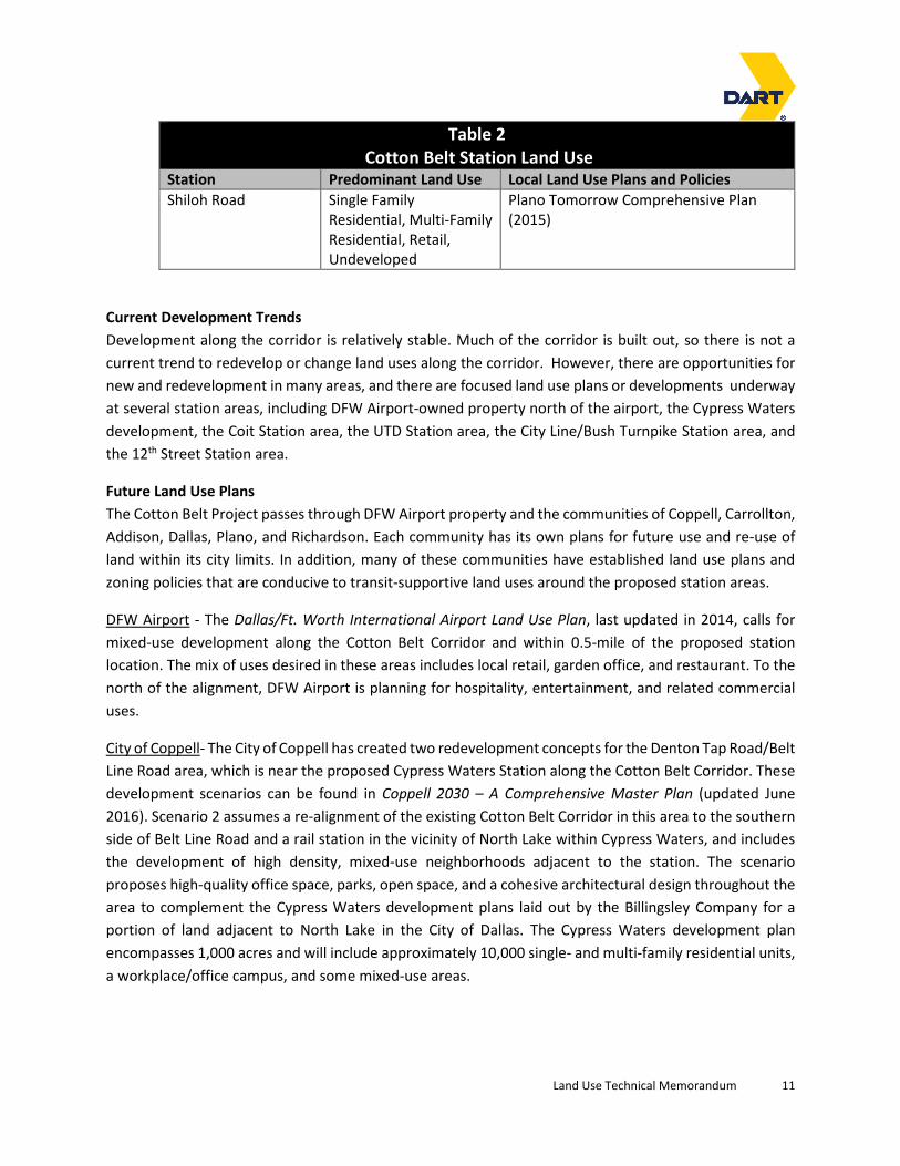
Shiloh Road Station: This proposed station area is located at Shiloh Road in the City of Plano. Land
use within the 0.5-mile buffer is approximately one-third industrial, one-third single-family and
multi-family residential, and one-third retail and undeveloped.

Land Use Technical Memorandum 10
Table 2
Cotton Belt Station Land Use
Station Predominant Land Use Local Land Use Plans and Policies
DFW Terminal B Airport Uses DFW Land Use Plan (2014)
DFW North Vacant, Industrial DFW Land Use Plan (future mixed-use
commercial)
Cypress Waters Residential, Commercial,
Industrial, Vacant
(development in
progress)
ForwardDallas! Comprehensive Plan
(2006)
Cypress Waters Master Developer
Agreement (2010)
City of Dallas Cypress Waters Tax
Increment Finance (TIF) district
Coppell 2030 – A Comprehensive Master
Plan
Downtown Carrollton Residential, Industrial,
Office, Retail
City of Carrollton Comprehensive Plan
Downtown Carrollton TOD Plan (2008)
Downtown Carrollton Master Plan
Addison Mixed-use TOD, Multi-
Family Residential,
Office, Medical, Retail,
Aviation
Town of Addison Comprehensive Plan
(2013)
Master Transportation Plan (2016)
Knoll Trail Office, Multi-Family
Residential, Retail
ForwardDallas! Comprehensive Plan
(2006) designated as transit center/ urban
neighborhood
Preston Road Single Family
Residential, Education,
Flood Control
ForwardDallas! Comprehensive Plan
(2006) designated as transit
center/residential neighborhood
Coit Road Single Family
Residential, Multi-Family
Residential, Commercial,
Education
ForwardDallas! Comprehensive Plan
(2006) designated as transit
center/commercial, urban and residential
neighborhood
UT Dallas Institutional (education),
Undeveloped, Office,
Single Family Residential
UTD Master Plan 2013 (future mixed-use
development)
UTD North Campus TOD Plan (2009)
City of Richardson Comprehensive Plan
(2009)
CityLine/Bush Mixed-use, Retail,
Office, Industrial
City of Richardson Comprehensive Plan
(2009)
City of Richardson Tax Increment
Financing Zone 2
12th Street Single Family
Residential, Vacant,
Industrial, Government,
Office, Retail
Plano Tomorrow Comprehensive Plan
(2015)
Downtown Plano Vision and Strategy
Update (2017)
Land Use Technical Memorandum 11
Table 2
Cotton Belt Station Land Use
Station Predominant Land Use Local Land Use Plans and Policies
Shiloh Road Single Family
Residential, Multi-Family
Residential, Retail,
Undeveloped
Plano Tomorrow Comprehensive Plan
(2015)
Current Development Trends
Development along the corridor is relatively stable. Much of the corridor is built out, so there is not a
current trend to redevelop or change land uses along the corridor. However, there are opportunities for
new and redevelopment in many areas, and there are focused land use plans or developments underway
at several station areas, including DFW Airport-owned property north of the airport, the Cypress Waters
development, the Coit Station area, the UTD Station area, the City Line/Bush Turnpike Station area, and
the 12th Street Station area.
Future Land Use Plans
The Cotton Belt Project passes through DFW Airport property and the communities of Coppell, Carrollton,
Addison, Dallas, Plano, and Richardson. Each community has its own plans for future use and re-use of
land within its city limits. In addition, many of these communities have established land use plans and
zoning policies that are conducive to transit-supportive land uses around the proposed station areas.
DFW Airport - The Dallas/Ft. Worth International Airport Land Use Plan, last updated in 2014, calls for
mixed-use development along the Cotton Belt Corridor and within 0.5-mile of the proposed station
location. The mix of uses desired in these areas includes local retail, garden office, and restaurant. To the
north of the alignment, DFW Airport is planning for hospitality, entertainment, and related commercial
uses.
City of Coppell- The City of Coppell has created two redevelopment concepts for the Denton Tap Road/Belt
Line Road area, which is near the proposed Cypress Waters Station along the Cotton Belt Corridor. These
development scenarios can be found in Coppell 2030 – A Comprehensive Master Plan (updated June
2016). Scenario 2 assumes a re-alignment of the existing Cotton Belt Corridor in this area to the southern
side of Belt Line Road and a rail station in the vicinity of North Lake within Cypress Waters, and includes
the development of high density, mixed-use neighborhoods adjacent to the station. The scenario
proposes high-quality office space, parks, open space, and a cohesive architectural design throughout the
area to complement the Cypress Waters development plans laid out by the Billingsley Company for a
portion of land adjacent to North Lake in the City of Dallas. The Cypress Waters development plan
encompasses 1,000 acres and will include approximately 10,000 single- and multi-family residential units,
a workplace/office campus, and some mixed-use areas.

Land Use Technical Memorandum 12
The most recent future land use map available on the City of Coppell website (revised July, 2016) identifies
mixed use or single-family residential at the intersection of Denton Tap Road and Belt Line Road. The rest
of the parcels are identified as light industrial/showroom on this future land use map.
The City of Coppell’s Thoroughfare Plan map from May 2008 identifies roadways that do not meet the
specifications of the thoroughfare plan. The map shows that Belt Line Road from Denton Tap Road to
MacArthur Boulevard has not been updated to meet the recommended capacity. It is specified to be a
six-lane divided roadway with a 110-foot total right-of-way width, but it is currently a four-lane divided
roadway.
City of Carrollton - The City of Carrollton published the Downtown Carrollton Station Master Plan in 2005
to establish a vision for this hub of future rail service. Several additional plans and studies were done
including the Downtown Carrollton Transit-Oriented Development, adopted in February 2008, to provide
a plan for transit-oriented development in downtown Carrollton and near the Green Line Station. The plan
outlines recommendations encompassing the downtown area, which would also be home to the proposed
Cotton Belt Downtown Carrollton Station. The plan calls for a slight grade separation of Belt Line Road in
order to alleviate some of the nuisance to drivers of being stopped by freight trains, thus making the
downtown area more attractive and less likely to be avoided due to freight traffic. The plan also
recommends ideas to improve walkability and conceptual land use plans to create a more active
downtown.
The City has also developed Transit Center Zoning sub-districts for the downtown area. The sub-districts
include Urban Core, Urban General, Historic Square, and Urban Fringe. Within all the sub-districts except
Urban Fringe, there are several areas in which ground-level retail is required. The City of Carrollton’s
future land use map (as amended by the City Council on December 6, 2007) depicts a large area of transit
land use that encompasses the entire downtown area, as well as extending west of IH 35E. The City’s
transit land use type falls under the broader category of “Mixed Use/Urban.”
The City’s Carrollton Trails Master Plan from 2006 identifies a bike and pedestrian trail along the
Burlington Northern Santa Fe (BNSF) rail alignment from the Green Line Downtown Carrollton Station and
proposed Cotton Belt Station area. This trail has been completed and is known as the Green Trail. The
master plan also identifies a bike and pedestrian trail along Le Mans Drive. This trail has been completed
and is known as the Purple Trail. Undated trail maps found on the trails page of the City’s website in 2017
show additional planned trails in the study area: along Crosby Road east to the Green Line, and then north
along the Green Line and along the Elm Fork of the Trinity River. No estimated construction dates have
been made available in the City of Carrollton’s planning documents for these trails.
Town of Addison - The Town of Addison currently has three capital improvement projects planned in the
project study area. The first project would widen Addison Road to five lanes. This project, however, is
currently being re-assessed. The Town of Addison will also undertake an Arapaho Road/DNT Bridge
modification to expand the bridge deck in order to create a free southbound to northbound U-turn. The
third capital project would reconfigure the Belt Line Road/DNT interchange into one intersection instead
of two.

Land Use Technical Memorandum 13
The Town of Addison Comprehensive Plan (2013) identifies city-owned property on the north side of the
Addison Station as well as 5.6 acres northeast of Quorum Drive and Arapaho Road that is being held for
TOD. Addison Circle Park is located north of the Addison Station and is the venue for several annual
community events, including Addison Kaboom Town and Oktoberfest. The Town of Addison also has a
Belt Line Road redevelopment plan called The Blueprint (2006). A portion of Belt Line Road, from just east
of Surveyor Boulevard to just east of Inwood Road, falls within 0.5 mile of the proposed station location.
This part of the town encompasses two districts, the Addison Dining District and Les Lacs Village, which
both abut the existing Cotton Belt Corridor on the south side and extend about one to two blocks south
of Belt Line Road. Both districts are envisioned to have mixed uses of either retail, residential, and office
(Les Lacs Village) or retail, residential, and restaurant (Addison Dining District). Les Lacs has more of a
residential focus, while Addison Dining District would have a more restaurant/entertainment focus with
areas of smaller, pedestrian-friendly blocks.
City of Dallas - The City of Dallas has documented their interest in fostering TOD and revitalization
opportunities that could be realized if Cotton Belt Project stations were to be constructed in the far North
Dallas area. The ForwardDallas! comprehensive plan adopted in June 2006, provides a work outline for
the development of a Coit Road/McCallum Boulevard area plan. The Coit Road/McCallum Boulevard
intersection falls within 0.5 mile of the proposed Coit Station location, and this area is also in proximity to
UTD. The area plan, once developed, will include a vision for the area, recommended zoning, a strategic
infrastructure investment program, and targeted economic development incentives. The comprehensive
plan states that the City of Dallas plans to move away from planned development zoning for mixed-use
projects in favor of form-based zoning codes. All three proposed Dallas stations are shown in the city’s
plan as transit centers.
ForwardDallas! also describes how the City will transition its street network over time to incorporate
context sensitive design (CSD) elements. Streets will have certain characteristics based on their primary
purpose. These new street types would be overlayed on the thoroughfare plan functional classification
system. CSD emphasizes creating two distinct realms, a pedestrian realm and a travelway realm. The
travelway realm would include various modes of transportation including bicycles. This is similar to the
concept of “complete streets.”
The City of Dallas has a master development agreement (2013) for the Cypress Waters project and
established a TIF for the area to take full advantage of the proposed Cypress Waters Station. The City’s
master plan agreement outlines the planned development comprised of traditional multi-family and
single-family neighborhoods, commercial development and retail areas. The Cypress Waters development
is located at the northeast corner of IH-635 and South Beltline Road and surrounding North Lake.
City of Richardson - The City of Richardson’s comprehensive plan, adopted by the City Council in January
2009, recommends that future land use along the City of Richardson portion of the alignment include
regional employment, transit village, public/semi-public/school, parks and open space, neighborhood
residential, multi-family residential, neighborhood service, community commercial, and office/industry.
The City, in collaboration with UTD and DART, also published a master plan for the UTD North Campus

Land Use Technical Memorandum 14
area including a proposed UTD Station along the Cotton Belt Corridor in June 2009. The station area
master plan includes a mixture of land uses, higher-density development, and pedestrian-friendly design
concepts to create a TOD around a proposed UTD Station. The station location used in the master plan is
to the west of the currently-proposed UTD Station area, but the concepts developed in the master plan
nonetheless remain relevant. Expansion into the North Campus and the University’s desire to gain
transit access to DFW Airport and the DART system via the Cotton Belt Corridor are also described in
UTD’s Campus Master Plan Update 2013.
A transit-oriented concept plan for the area east of the proposed Bush Turnpike Station and east and
west of US 75 (North Central Expressway) has also been developed. The recent rezoning of the area
included a reservation of land for the Red Line Interface South Alternative that would deviate from the
Cotton Belt Corridor.
City of Plano - The City of Plano’s comprehensive plan was adopted in October 2015. The plan includes
TOD aspects to proactively encourage development within walking distance of existing and future rail
stations or bus transit centers to create an integrated mix of uses including residential, employment,
retail, and civic spaces. Also included is a commitment to develop plans to address redevelopment of retail
and multifamily sites and to encourage new development around transit stations.
The City of Plano published a vision and strategy update for the proposed 12th Street Station in January
2017. This document acknowledges the 12th Street Station as an important feature for the south side of
downtown Plano that will act as a magnet for new development. The 12th Street Station area is described
as offering many development opportunities and is well suited for infill projects, including townhomes,
live/work space and small offices and studios. The City has purchased approximately 3 acres of land for
12th Street Station parking.
Municipal Land Use, Zoning, and Growth Policies
This section identifies the general zoning types currently in place within the 0.5-mile station area buffers
and along the 0.25-mile alignment buffer. Each municipality is responsible for establishing zoning districts
for property within its city limits.
DFW Airport to Carrollton
Alignment: The mix of land uses planned for the station area are also planned along the alignment east
of DFW North Station. Once the alignment leaves airport property and enters the Coppell, current zoning
includes Light Industrial (LI), Historic (H, PD-H), Commercial (C), and Single-Family Residential (SF-9, SF-7).
Zoning along the alignment through Coppell city limits includes Single-Family Residential (SF-9, SF-12),
Commercial (C, PD-C), Agricultural (A), Office (PD-O), Light Industrial (LI, PD-LI), Retail (R), and Multi-Family
Residential (MF-2, PD-MF-2).
DFW North Station Area: DFW Airport owns the majority of the property within the 0.5-mile radius around
the proposed station location, and the DFW property does not have typical zoning designations. The area
around the proposed station location is planned by DFW Airport for a mix of local retail, restaurant, and

Land Use Technical Memorandum 15
garden office uses. City of Grapevine zoning for outlying property within the 0.5-mile buffer includes Light
Industrial (LI), Community Commercial (CC), Residential (R-7.5), and Business Park (BP).
Cypress Waters Station Area: Current zoning includes Single-Family Residential (SF-9, SF-12), Agricultural
(A), Commercial (C), Light Industrial (LI), and Dallas zoning designation Industrial/Utility (I).
Downtown Carrollton Station Area: The proposed Downtown Carrollton Station area includes the
following zoning categories: Single-Family Residential (SF-12/20), Special Use Permit (SUP), Light
Industrial (LI), Local Retail (LR-1, LR-2), and Neighborhood Services (NS).
Carrollton to Coit Road
Alignment: The 0.25-mile buffer along the Cotton Belt alignment from the Coppell/Carrollton city limits
to Kelly Boulevard includes the following zoning categories: Planned Development (PD), Light Industrial
(LI), Special Use Permit (SUP), Single-Family Residential (SF-5/12, SF-7/14, SF-10/18, SF-TH), Historic
Preservation Overlay (HP-1), Duplex Residential (D), Multi-Family Residential (MF-15, MF-18, MF-45), and
Local Retail (LR-2). Zoning along the alignment within the town of Addison includes Industrial (I-1, I-2),
Parks (P), Planned Development (PD, PD-4), Commercial (C-1), and Urban Center (UC).
Addison Station Area: The proposed Addison Station area includes the following zoning categories:
Industrial (I-1, I-2, I-3), Parks (P), Planned Development (PD), Local Retail (LR), and Commercial (C-1).
Knoll Trail Station Area: The Knoll Trail Station area includes the following City of Dallas zoning categories:
Mixed Use (MU-1), Multi-Family Residential (MF-1(A)), Special Use Permit (SUP), Planned Development
(PD), Retail (R-16(A)), Regional Retail (RR), Multiple Commercial (MC-4), Agriculture (A(A)), and
Community Retail (CR).
Preston Road Station Area: The Preston Road Station area includes the following City of Dallas zoning
categories: Residential (R-1AC(A), R-10(A), R-16(A)), Planned Development (PD), Special Use Permit (SUP),
Townhouse (TH-1(A), TH-3(A)), Neighborhood Office (NO (A)), Multi-Family Residential MF-1(A)), and
Agriculture (A(A)).
Coit Road Station Area: The Renner Village Station area includes the following City of Dallas zoning
categories: Special Use Permit (SUP), Residential (R-5(A)), Clustered Housing (CH), Commercial Service
(CS), Mixed Use (MU-1), Community Retail (CR), Multi-Family Residential (MF-2(A), MF-3(A)), Planned
Development (PD), Townhouse (TH-3(A)), and Agriculture (A(A)).
Coit Road to Shiloh Road
Alignment: Zoning around the alignment within the city of Dallas includes the following categories:
Single-Family Residential (R-7.5(A), R-10(A)), Multi-Family Residential (MF-1(A)), Townhouse (TH-3(A), TH-
2(A)), Parking (P(A)), Neighborhood Service (NS (A)), Duplex (D(A)), and Special Use Permit (SUP). The
alignment within the city of Richardson includes the following zoning categories: Commercial (SPL C-M),
Planned Development (PD), Industrial (SPL I-M(1)), Residential (R-1500-M, Temp R-1500-M), and

Land Use Technical Memorandum 16
Technical Office (SPL TO-M). Along the alignment within the city of Plano, zoning categories include:
Multi-Family Residential (MF-2), Light Industrial (LI-1, LI-2), Retail/Office (R/O-2), Planned Development
(PD), SH 190 Overlay District, Specific Use (S), Retail (R), Two-Family Residence (2F), Light Commercial (LC),
and Research/Technology Center (RT).
UT-Dallas Station Area: The UT-Dallas Station area includes the following City of Richardson zoning
categories: Technical Office (SPL TO-M), Planned Development (PD), and Residential (SPL R-2000-M, SPL
R-1500-M, Temp R-1500-M). It also includes the following City of Plano zoning categories: SH 190 Overlay
District and Agriculture (A).
CityLine/Bush Turnpike Station Area: The City Line/Bush Turnpike Station area includes the following City
of Richardson zoning categories: Residential (Temp R-1500-M), Technical Office (SPL TO-M), Commercial
(SPL C-M), Planned Development (PD, SPL PD), and Industrial (SPL I-M(1)). In February 2011,
approximately 160 acres in the station vicinity were approved for rezoning to become zoned as Planned
Development. It also includes the following City of Plano zoning categories: R/O-2 (Retail/Office), SH 190
Overlay District, Light Industrial (LI-1), Planned Development (PD), Light Commercial (LC), Special Use (S),
and Corridor Commercial (CC).
12th Street Station Area: The 12th Street Station area includes the following City of Plano zoning categories:
Planned Development (PD), Corridor Commercial (CC), Light Industrial (LI-1, LI-2), Light Commercial (LC),
Specific Use (S), Two-Family Residence (2F), Single-Family Residential (SF-6), Downtown
Business/Government (BG), General Residential (GR), and Heritage Resource Designation (H-33).
Shiloh Road Station Area: The Shiloh Road Station area includes the following City of Plano zoning
categories: Single-Family Residential (SF-6, SF-7), Multi-Family Residential (MF-1, MF-2), Retail (R),
Planned Development (PD), Light Commercial (LC), Specific Use (S), Research/Technology Center (RT), and
SH 190 Overlay District.

Land Use Technical Memorandum 17
APPENDIX A – ENVIRONMENTAL ASSESSMENT METHODOLOGY
TECHNICAL MEMORANDUM

Land Use Technical Memorandum 18
TECHNICAL MEMORANDUM
Date: Wednesday, March 22, 2017
Project: Task Order 32, Cotton Belt Corridor PE/EIS
To: John Hoppie, Project Manager, DART Capital Planning
From: Tom Shelton, GPC6 Program Manager
Subject: DART GPC VI; Contract Number: C-2012668; Cotton Belt Corridor Environmental (WOTUS,
Ecosystems, EJ, Air Quality and Land Use) Assessment Methodology
Introduction: This technical memorandum presents the proposed methodology for conducting field
surveys for identifying and updating the following resources within the Cotton Belt Corridor project in
support of the EIS preparation: Waters of the U.S. and Wetlands (WOTUS), Ecosystems, and
Environmental Justice (EJ) populations, Air Quality and Land Use. Existing technical memorandums
(2013) prepared for the Cotton Belt Corridor Project Alternatives and Environmental Considerations
Report (AECR) have been reviewed by the GPC6 team and will provide a baseline for the current studies.
Additional technical memorandums will be prepared under separate cover for other resource
categories. As the alignment and station locations are refined, additional field surveys may be necessary.
Project Description: The 26-mile Cotton Belt Corridor extends between DFW Airport and Shiloh Road in
Plano. The alignment traverses seven cities: Grapevine, Coppell, Dallas, Carrollton, Addison, Richardson
and Plano. The Cotton Belt Project’s primary purpose is to provide passenger rail connections and
service that will improve mobility, accessibility and system linkages to major employment, population
and activity centers in the northern part of the DART Service Area. The Cotton Belt Project would
interface with three DART Light Rail Transit (LRT) lines: The Red Line in Richardson/Plano, the Green Line
in Carrollton and the Orange Line at DFW Airport. Also at DFW Airport, the project would connect to
Fort Worth Transit Authority's TEX Rail Regional Rail Line to Fort Worth and the DFW Airport Skylink
People Mover.
Objective: DART is preparing an Environmental Impact Statement (EIS) to assess the impacts and
benefits of rail passenger service on the Cotton Belt Corridor. Project oversight will be conducted by the
Federal Transit Administration (FTA) in cooperation with the Federal Railroad Administration (FRA) and
the Federal Aviation Administration (FAA).

Land Use Technical Memorandum 19
METHODOLOGY
Waters of the U.S.: Recent aerial photography, U.S. Geological Survey (USGS) National Hydrography
Dataset, U.S. Fish and Wildlife Service (USFWS) National Wetlands Inventory, and USGS topographic
maps (7.5-minute series) of the study area will be used to identify potential locations for waters of the
U.S. and areas prone to wetland development before going into the field. Potential waters of the U.S.
identified, including wetlands, will be delineated and evaluated using routine on-site methods between
April 3 and April 21, 2017 by GPC6 environmental scientists. The surveys will be conducted in
accordance with the USACE 1987 Wetlands Delineation Manual (Environmental Laboratory, 1987) and
the Regional Supplement for the Great Plains Region (USACE, 2010). The delineations will also be
performed to reflect current guidance, Rapanos Guidance, from the USACE and EPA on jurisdictional
determination in accordance with U.S. Supreme Court rulings. The delineations will be recorded using a
Trimble® sub-meter Geo XT Global Positioning System unit and mapped as a data layer using ArcGIS
10.4. The field delineation will be conducted by foot. Vehicles for field personnel will be parked within
DART right-of-way while areas are being delineated. GPC6 biologists will be collecting GPS data for the
ordinary high water mark of all streams, boundaries of all wetlands, and data points in wetlands and
uplands. They will also be collecting photos and taking field notes on data forms and maps.
Ecosystems: The GPC6 project team will review recent aerial photography, USGS topographic maps,
Texas Parks and Wildlife Department (TPWD) Natural Diversity Database, TPWD’s Ecological Mapping
Systems vegetation data, and USFWS and TPWD county list of threatened, endangered, and rare
species, prior to conducting fieldwork for the DART Cotton Belt project. GPC6 environmental scientists
will conduct a field survey to identify habitat types, land use, and vegetation types present within the
project corridor between April 3 and April 21, 2017. During the field survey, GPC6 Environmental
Scientists will record notable species (such as threatened, endangered, or rare species) or active bird
nests or roosts observed during the survey.
Environmental Justice: U.S. Census data at the block (minority) and block group (low-income) level will
be used to identify areas within one mile of the proposed Cotton Belt line containing minority or low-
income populations. Census blocks which have a meaningfully greater percentage of minority
population than the surrounding county area or more than 50 percent minority would be considered to
contain a minority population. Census block groups which have a median household income that is
below the 2017 Department of Health and Human Services poverty guideline for a family of four or
where the percentage of residents in poverty meaningfully exceeds the level found in the surrounding
county will be considered to contain a low-income population. Field investigations will identify any areas
of low-income housing, services catering to particular ethnic or economic groups, or signs in languages
other than English. GPC6 environmental scientists will conduct the field activities between April 3 and
April 21, 2017 via windshield surveys within the study area.

Land Use Technical Memorandum 20
Air Quality: Potential stationary sources of air pollutants, sites of future projects, and sensitive receptors
will be noted and photographed during field investigations. Current aerial photography and
comprehensive plans for the cities of Grapevine, Coppell, Dallas, Carrollton, Addison, Richardson, and
Plano will be reviewed to identify potential areas of development and sources of air pollution. Current
aerials and business listings will be searched prior to field investigations to identify any sensitive
receivers that could be affected by impacts to air quality. The investigations will be done by GPC6
environmental scientists between April 3 and April 21, 2017. The investigations will be conducted by
vehicle and on foot within the DART right-of-way.
Land Use: Review of existing land use along the project corridor will be accomplished by identifying and
reviewing the most recent data from NCTCOG and other relevant sources. The project area will be
categorized using this data to identify the most recent condition as well as trends of development
through the use of ArcGIS mapping and analysis. The project study area for land use will be one-quarter
mile on either side of the Cotton Belt Corridor and one-half mile radius around each proposed station
location. Field verification will be conducted along the corridor during the period of April 3 to April 21,
2017. GPC6 environmental scientists will conduct field surveys. Land use will be classified by accessing
DART property and public access right-of-ways. Field data collection will be performed through the use
of GPS and ground level photography. Economic and residential zones will be classified, as well as public
and private facilities including parks, churches, schools and other community resources.


