SEDA-COG METROPOLITAN PLANNING ORGANIZATION (MPO) AVIATION SUBCOMMITTEE MEETING
July 29, 2013
10:00 A.M. – 12:00 P.M. SEDA-COG
Lewisburg, PA
MEETING AGENDA A. Call to Order and Introductions .......................................................................... J. Saylor
B. Overview of Economic Impact of Airports in the Region ................................. J. Saylor
C. Overview of PA Airport Planning Process ........................................................ J. Saylor
D. Overview of Hazard Zoning Ordinance ............................................................. J. Saylor
E. Guidance Issues ................................................................................................. J. Saylor
F. Open Discussion – Issues and Opportunities ..................................................... J. Saylor
G. Adjournment ...................................................................................................... J. Saylor
Lunch will begin at 12:00 p.m.


Questions for the Aviation Subcommittee
1. What are the opportunities for the MPO members and staff to help airport operators in the region?
2. What future steps does the MPO need to implement to take advantage of these opportunities?
3. How should the MPO handle the region’s airports in other planning efforts?


4. To achieve the answers to #’s 3 and 4, when and how often should the subcommittee meet?
5. What items should be on the agenda for the next meeting?


Airport ID Associated City Airport Name
Total Employment Total Payroll Total Output
N13 Bloomsburg Bloomsburg Municipal Airport 26 $899,100 $3,812,500
8N8 Danville Danville Airport 13 $399,900 $1,360,100
02P Honey Grove Stottle Memorial Heliport 2 $54,200 $51,100
LHV Lock Haven William T. Piper Memorial Airport 51 $1,936,000 $6,835,400
P34 Mifflintown Mifflintown Airport 13 $327,900 $1,199,300 RVL Reedsville Mifflin County Airport 11 $286,900 $1,254,000 SEG Selinsgrove Penn Valley Airport 51 $1,225,900 $3,895,100
N79 Shamokin Northumberland County Airport 13 $387,000 $1,773,200
71N Sunbury Sunbury Airport 2 $54,200 $189,900 Total for Airports in SEDA‐COG MPO Counties 182 $5,571,100 $20,370,600
8,548 $339,691,800 $1,310,341,000 304,462 $9,168,176,100 $23,645,278,100
Summary of Total Impacts by Airport
Pennsylvania General Aviation Airports Total Total All Pennsylvania Airports
B 1

photo: Commonwealth of Pennsylvania
B 2

3
The Pennsylvania Airport SystemAt the time of this study in 2010, Pennsylvania’s system of public air-ports was comprised of 15 commer-cial service and 116 general aviation airports. The Pennsylvania Depart-ment of Transportation (PennDOT) Bureau of Aviation manages pro-grams that support the operation and development of these airports
through grant funding, inspections, technical guidance, planning stud-ies, education efforts, and commu-nication with local, state, and federal officials. The Bureau of Aviation also works closely with various aviation associations, including the Aviation Council of Pennsylvania.
B 3

4
Study MethodologyThe methodology used to measure the economic impact of Pennsylva-nia’s airports follows guidelines set forth by the Federal Aviation Ad-ministration (FAA). Economic im-pacts for all airports were classified into three impact categories: direct, multiplier (indirect/induced), and total.
Direct impacts include both direct impacts related to on-airport busi-nesses and government agencies and impacts which generally take place off-airport and are usually at-tributable to visitor spending.
Multiplier impacts are comprised of indirect and induced impacts. These impacts are attributed to em-ployees spending their earnings at
local businesses and the on-airport businesses purchasing goods and services locally. This re-circulation is commonly referred to as the “multi-plier effect.”
Total annual economic impacts are the sum of direct and multi-plier impacts. For this study, each airport’s annual economic impacts were summed to reflect the total economic impact that Pennsylva-nia’s economy receives from com-mercial service and general aviation airports.
The majority of the economic ben-efits measured in this study are ex-pressed in terms of jobs, payroll, and annual economic activity or output.
On-AirportOutput
VisitorOutputDirect
Impacts
MultiplierImpacts
TotalImpacts
Total JobsTotal PayrollTotal Output
Induced IndirectOutput
B 4
C 1
DESK REFERENCE | PennDOT Publication 405 – Aviation Development Airport Sponsor’s Guide
4
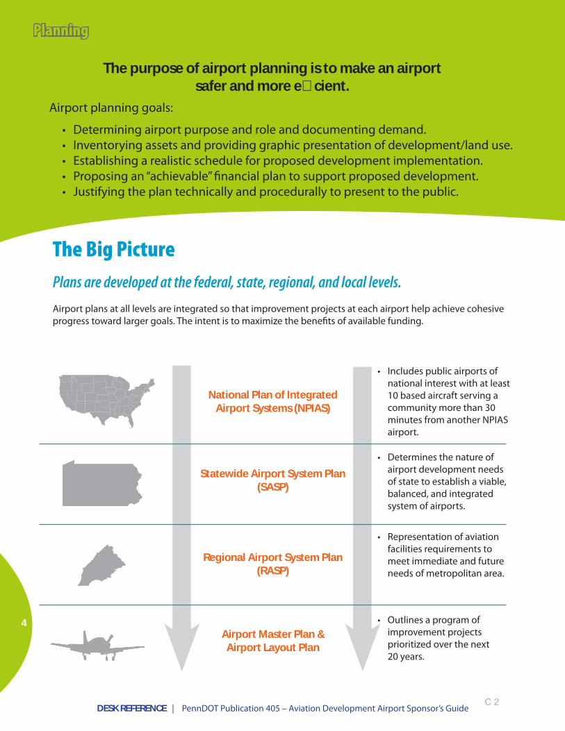
The purpose of airport planning is to make an airport safer and more e�cient.
Airport planning goals:
• Determining airport purpose and role and documenting demand.• Inventorying assets and providing graphic presentation of development/land use.• Establishing a realistic schedule for proposed development implementation.• Proposing an “achievable” financial plan to support proposed development.• Justifying the plan technically and procedurally to present to the public.
The Big PicturePlans are developed at the federal, state, regional, and local levels. Airport plans at all levels are integrated so that improvement projects at each airport help achieve cohesive progress toward larger goals. The intent is to maximize the benefits of available funding.
Airport Master Plan & Airport Layout Plan
Regional Airport System Plan (RASP)
Statewide Airport System Plan (SASP)
National Plan of Integrated Airport Systems (NPIAS)
• Includes public airports of national interest with at least 10 based aircraft serving a community more than 30 minutes from another NPIAS airport.
• Determines the nature of airport development needs of state to establish a viable, balanced, and integrated system of airports.
• Representation of aviation facilities requirements to meet immediate and future needs of metropolitan area.
• Outlines a program of improvement projects prioritized over the next 20 years.
Planning
C 2

DESK REFERENCE | PennDOT Publication 405 – Aviation Development Airport Sponsor’s Guide
5
PlanningStatewide Airport System PlanAnalyzes how Pennsylvania airports measure up against key criteria and helps prioritize improvements from a system-wide view
The Statewide Airport System Plan (SASP) is a comprehensive study that provides BOA with the tools to make decisions about the performance, enhancement, and promotion of Pennsylvania’s air transportation system. The role of each airport within the system is defined, and standards are established for airports of various types and categories. Projects that help airports get up to par are given a higher priority for funding.
The SASP establishes standards and criteria for airports by category and analyzes how Pennsylvania’s airports measure up.
Pennsylvania Airport Standards and Criteria by Category (from 2007 SASP)
Improvements in the “State of the System,” 2007 - 2012
Amenity/Service Commercial Service Advanced Intermediate2007 2012 2007 2012 2007 2012
Runway Length 100% 100% 100% 100% 43% 48%
Runway Width 100% 100% 100% 100% 62% 71%
Runway Strength 73% 80% 73% 100% 71% 95%
Taxiway 73% 87% 80% 93% 43% 67%
NAVAIDS 73% 93% 40% 47% 62% 76%
Approach Aids 67% 93% 33% 53% 52% 62%
Runway Edge Lights 100% 100% 100% 100% 71% 81%
Weather 100% 100% 100% 100% 52% 71%
Facilities 100% 100% 100% 100% 76% 95%
Services 100% 100% 100% 100% 57% 90%
Amenity/Service1 Commercial Service2 Advanced IntermediateRunway Length 5,000 ft 4,500 ft 3,800 ft
Runway Width ARC C-II ARC B-II ARC B-II
Runway Strength >60,000 lbs SW >30,000 lbs SW >12,500 lbs SW
Taxiway Full parallel Full parallel Full parallel
NAVAIDS 200 ft & 1/2 mile 400 ft & 3/4 mile 600 ft & 1 mile
Approach Aids Beacon, wind cone, REILS, PAPIs, MALSR
Beacon, wind cone, REILS, PAPIs, ALS Beacon, wind cone, REILS, VGSIs
Runway Edge Lights HIRLs HIRLs or MIRLs MIRLs
Weather ASOS/AWOS ASOS/AWOS ASOS/AWOS
Facilities FBO, phone, bathroom, jet fuel, repairs, ground transportation
FBO, phone, bathroom, jet fuel, repairs, ground transportation
FBO, phone, bathroom, jet fuel, repairs, ground transportation
Services Aircraft & auto parking, storage, terminal
Aircraft & auto parking, storage, terminal
Aircraft & auto parking, storage, terminal
1Amenity/Service criteria categories are from the 2002 SASP2 Commercial Service airports must also have a CFR Part 139 Class I, II, or III Certification
Note: Details on all five airport classifications, including “Basic” and “Limited,” are provided in the full SASP, available on the BOA website.
C 3

DESK REFERENCE | PennDOT Publication 405 – Aviation Development Airport Sponsor’s Guide
6
Planning
several chapters, including:
Airport Mission, Goals, and Objectives
Environmental Impacts
Updated Airport Layout
Plan
Capital Improvement
Plan
Financial Feasibility
Study
Inventory of Existing
Conditions
Demand Forecast
Statement of Facilities
Requirements
Alternatives
Airport Master Plan
• developed through robust stakeholder and public involvement
• considers airport needs in the near-term (within 5 years), mid-term (within 10 years), and long-term (within 20 years)
Airport Master PlanOutlines a program of improvement projects prioritized over the next 20 years
Required Airport-Level (Local) Plans
m Airport Master Plan
m Airport Layout Plan
See Programming section for Capital Improvement Plan, Transportation Improvement Plan, and Four-Year Plan.
C 4

DESK REFERENCE | PennDOT Publication 405 – Aviation Development Airport Sponsor’s Guide
7
Planning
• Airport’s plan—but an official federal document
• Must be on file with BOA to be considered for funding
• Only development depicted on an approved ALP is eligible for federal funding
• Approved by the airport sponsor and the FAA/BOA via the State Block Grant Program
• A public document that is updated every 5 to 10 years
• Facilitates planning and programming, community and airport land use decisions, and protection of airspace
Airport Layout Plan (ALP)Depicts existing facilities and proposed development
Airport Layout Plan
3 to 14 sheets, including:
3 to 14 sheets included in ALP drawing set:
For details go to:
of:
C 5

DESK REFERENCE | PennDOT Publication 405 – Aviation Development Airport Sponsor’s Guide
10
Programming uses airport planning to develop a prioritized list of projects that can be completed with available funding.
Airport programming involves collaboration among BOA, FAA, airports, and consultants to:
• Verify that proposed projects are eligible for federal/state funding.• Ensure projects are consistent with the goals of various plans.• Scope, score, and rank priority projects.• Balance costs and benefits to produce the greatest value with limited funds.
JACIP – Joint Automated Capital Improvement ProgramA web-based tool to help track Pennsylvania’s aviation programming
JACIP is used by airport sponsors, BOA, and FAA to manage their interrelated planning and programming responsibilities.
For details go to:
and:
of:
JACIP is…. • an aviation project programming tool with many automated
features such as project coding and scoring capabilities.• a simplified, user-friendly data entry port for electronic
submission of Twelve-Year Plans and Datasheets.• an Internet database application that tracks, analyzes, and
reports on airport capital improvement data as well as other planning-related information such as airport facility and services inventory.
• an efficient mechanism to share real-time information on airport development needs and proposed projects included in the Four-Year Plan.
• a flexible report generator for both individual airport or statewide analysis.
• a repository of state system plan and zoning information.
Programming

DESK REFERENCE | PennDOT Publication 405 – Aviation Development Airport Sponsor’s Guide
11
Programming
Eligible local projects become part of BOA’s statewide FYP and TYP, competing with other Pennsylvania airport projects for funding.
State Programming – Twelve-Year and Four-Year Plan Programs (TYP/FYP)There are TYPs and FYPs at the local and state levels. These “plans” are actually programs.
Airport Twelve-Year Plan
Years 1-41 project details
2 project details
3 project details
4 project details
5 project details
6 project details
Years 5-87 project details
8 project details
9 project details
10 project details
11 project details
Years 9-1212 project details
13 project details
14 project details
15 project details
16 project details
17 project details
18 project details
19 project details
20 project details
(no specific number of projects)
Pennsylvania Twelve-Year Plan
Years 1-4project project project project project project
project project project project project project
project project project project project project
project project project project project project
project project project project project project
project project project project project project
project project project project project project
project project project project project project
project project project project project project
project project project project project project
project project project project project project
project project project project project project
Years 5-8project project project project project project
project project project project project project
project project project project project project
project project project project project project
project project project project project project
project project project project project project
project project project project project project
project project project project project project
project project project project project project
Years 9-12project project project project project project
project project project project project project
project project project project project project
project project project project project project
project project project project project project
project project project project project project
project project project project project project
project project project project project project
project project project project project project
project project project project project project
project project project project project project
project project project project project project
project project project project project project
Airport Four-Year Plan
Statewide Four-Year Plan
Capital Improvement
Plan
Airport Master Plan
Airports work with BOA to develop Twelve-
Year Plans based on needs identified
in their Capital Improvement Plans.
An airport’s Twelve-Year Plan is a prioritized list of its projects and funding needs over the next 12 years.
An airport’s Four-Year Plan is the first four years of the Twelve-Year Plan—the top priority projects that are ready to move forward. These projects compete for funding and inclusion in the statewide Four-Year Plan. They are ranked by BOA using BOA criteria and FAA National Priority Rating Criteria.
C 7

DESK REFERENCE | PennDOT Publication 405 – Aviation Development Airport Sponsor’s Guide
12
Programming
JANUARY2. Development
BOA uses airport TYPs & FYPs to develop the statewide Four- Year Plan, ranking projects according to the FAA’s National Priority Rating criteria and BOA’s selection criteria.FEBRUARY
MARCH3. Verification
Airport sponsors and planning partners review and comment on the draft FYP.
APRIL4. Approval
The updated and verified FYP is presented to PennDOT’s Program Management Committee and the State Transportation Commission for approval.MAY
JUNE
JULYGrant offer and award process begins
1. Planning and SubmissionBOA conducts annual mandatory planning sessions each fall with airport sponsors wishing to apply for federal and/or state aviation grant funding.
Airport sponsors develop and refine their Four- and Twelve-Year Plans, which include complete and accurate cost estimates and other project details.
AUGUST
SEPTEMBER
OCTOBER
NOVEMBER
by December 1 - Airport sponsors submit their Four- and Twelve-Year Plans to BOA via JACIP
DECEMBER
BOA Annual Programming ScheduleThe state-level Twelve-Year and Four-Year Plans (TYP/FYP) are updated and reprioritized every year.
START The process begins in late summer
Programming must be “fiscally constrained,” meaning total project costs must not exceed total expected funding.
C 8

DESK REFERENCE | PennDOT Publication 405 – Aviation Development Airport Sponsor’s Guide
• BOA administers three grant programs and a real estate tax reimbursement program.• Grants are for public-use airports only.
Grant State Block Grant Program (SBGP)
Aviation Development Program (ADP)
Capital Budget Program
Also Known As Airport Improvement Pro-gram (AIP)
Transportation Assistance Program (TAP)
What is the funding source?
Taxes collected nationally on airline tickets, freight waybills, international departure fees, and aviation fuel sales deposited into the FAA Trust Fund.1
Taxes collected on jet fuel sales deposited into Penn-sylvania’s Aviation Restricted Account
Commonwealth’s General Fund’s Transportation As-sistance Program
Who is eligible?
Non-primary General Avia-tion Airports included in the National Plan of Integrated Airport Systems
Public-Use Airports Public-use/publicly-owned airports with active Capital Budget Act projects
How are proposed projects evaluated?
FAA Order 5100.39, Airports Capital Improvement Plan, and FAA Order 5100.38C, The Airport Improvement Program (AIP) Handbook
Provisions of the Aviation Code (74Pa.C.S. Part II), BOA’s aviation grant regu-lations, and State Project Selection Criteria Guidelines
Provisions of the Aviation Code (74Pa.C.S. Part II), BOA’s aviation grant regu-lations, and State Project Selection Criteria Guidelines
What is the funding split?
Funds may be allocated up to 90 percent of the total cost of an eligible project at an SBGP airport.
Funds may be allocated up to 90 percent of the total cost of an eligible project, or 50 percent of the non-federal share of a federally funded project.2
• Federally eligible projects: up to 75 percent of non-federal share
• Non-federally eligible projects: up to 50 percent of the project cost
What is the deadline for requesting funding? December 1 via JACIP December 1 via JACIP December 1 via JACIP
What is the funding �scal year? October 1 to September 30 July 1 to June 30 July 1 to June 30
When is the funding typically available?
in spring of fiscal year July July
When are Tentative Allocations (TAs) sent? March/April July September/October
What is the length of the grant? 3 years 3 years 3 years
Overview of Grant Programs
Grants and Funding
1Airport Improvement Program (AIP) is the source of SBGP funds.290 percent funding is generally reserved for approved “Safety” related projects. “Non-safety” projects are generally limited to 50-75 percent of the project cost.
13
C 9
DESK REFERENCE | PennDOT Publication 405 – Aviation Development Airport Sponsor’s Guide
14
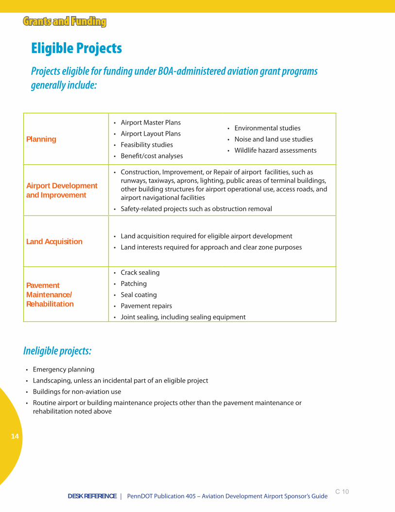
Grants and Funding
Planning
• Airport Master Plans
• Airport Layout Plans
• Feasibility studies
• Benefit/cost analyses
• Environmental studies
• Noise and land use studies
• Wildlife hazard assessments
Airport Development and Improvement
• Construction, Improvement, or Repair of airport facilities, such as runways, taxiways, aprons, lighting, public areas of terminal buildings, other building structures for airport operational use, access roads, and airport navigational facilities
• Safety-related projects such as obstruction removal
Land Acquisition• Land acquisition required for eligible airport development
• Land interests required for approach and clear zone purposes
Pavement Maintenance/Rehabilitation
• Crack sealing
• Patching
• Seal coating
• Pavement repairs
• Joint sealing, including sealing equipment
Eligible ProjectsProjects eligible for funding under BOA-administered aviation grant programs generally include:
Ineligible projects:• Emergency planning
• Landscaping, unless an incidental part of an eligible project
• Buildings for non-aviation use
• Routine airport or building maintenance projects other than the pavement maintenance or rehabilitation noted above
C 10

Airport Hazard Zoning: Models Based on FAR Part 77
According to PA Act 164, municipalities within the Federal Aviation Administration (FAA) Federal Regulation 14 CFR Part 77 (i e "Part 77”) areasAdministration (FAA) Federal Regulation 14 CFR Part 77 (i.e., Part 77 ) areas around an airport are required to have ordinances that restrict the height of objects that could interfere with airport operations.
These height restrictions gradually change from 0 feet directly at the airport up to about 1920 feet above the airport runway surface, depending upon the distance from the airport and type of runways in use.
The height restrictions are broken into 5 Surface Zones, which are defined by FAA and are a function of the airport’s physical and runway featuresFAA and are a function of the airport s physical and runway features.
1D 1

PA Airport Statistics
Over 120 public use airportsAbout 680 municipalities required to enact Airport Hazard ZoningAbout 159 municipalities have Airport Hazard Z i i ff tZoning in effect
2D 2

Airport Hazard Zoning: Purpose?
Restricts heights of objects around airport areas to provide for safeairport areas to provide for safe aircraft flight paths.
3D 3

Obstructions to Approach SurfaceApproach Surface
4D 4

Obstructions to Approach Surface
5D 5

Airport Hazard Zoning: Why is it needed? SafetySafety
Safety – Protecting Pilots, Passengers, People and PropertyIdentifies possible obstructions before they occur– Identifies possible obstructions before they occur
– Restricts heights of objects in and around airports so they will not interfere with aircraft operationsP id li k t i ti f d l d t t th t– Provides a link to existing federal and state processes that evaluate airspace for objects, existing or proposed, to prevent and/or mitigate hazards R d th ibilit f id t th t ld i j b th– Reduces the possibility of accidents that could injure both passengers and people on the ground
– Protects against liability
6D 6
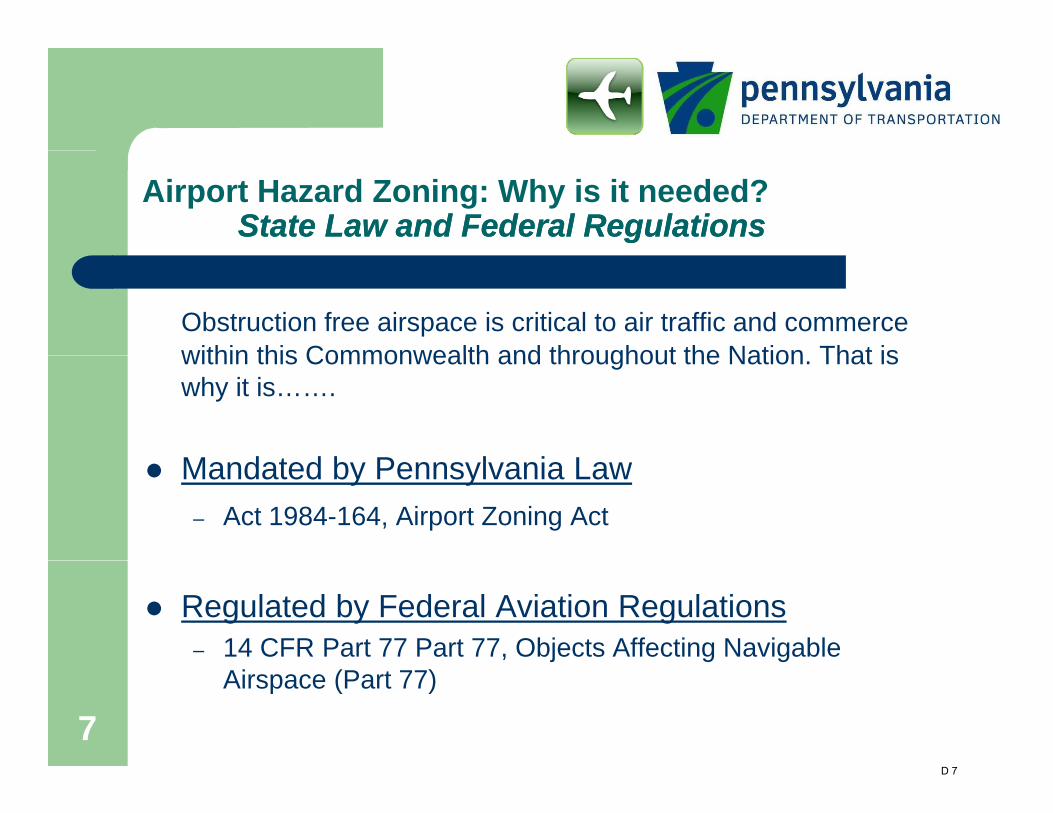
Airport Hazard Zoning: Why is it needed? State Law and Federal RegulationsState Law and Federal Regulations
Obstruction free airspace is critical to air traffic and commerce within this Commonwealth and throughout the Nation That iswithin this Commonwealth and throughout the Nation. That is why it is…….
M d t d b P l i LMandated by Pennsylvania Law– Act 1984-164, Airport Zoning Act
Regulated by Federal Aviation Regulations– 14 CFR Part 77 Part 77, Objects Affecting Navigable
7Airspace (Part 77)
D 7

Assistance for Adoption and Administration
DCED fundingF di il bl f di d ti i LUPTAP– Funding available for ordinance adoption via LUPTAP Grants
Airport Grants – Funding available to airport for Multi-municipal Ordinance
Overlay development/adoption.– Funding available to airport for Part 77 obstruction g p
mitigation
Technical Assistance BOA works with airports to resolve zoning issues and
34
– BOA works with airports to resolve zoning issues and provide technical assistance on Part 77.
D 8

Airport ID Airport Name Municipality County
Act 164 Ordinance in
Place?
Town of Bloomsburg Columbia YesScott Township Columbia YesCatawissa Township Columbia NoHemlock Township Columbia NoMain Township Columbia NoDanville Borough Montour NoMahoning Township Montour NoPoint Township Northumberland NoRiverside Borough Northumberland YesRush Township Northumberland YesBald Eagle Township Clinton YesCastanea Township Clinton NoCity of Lock Haven Clinton NoDunnstable Township Clinton NoWayne Township Clinton YesWoodward Township Clinton YesFermanagh Township Juniata YesMilford Township Juniata NoArmagh Township Mifflin YesBrown Township Mifflin YesDerry Township Mifflin NoGranville Township Mifflin NoLower Augusta Township Northumberland NoUpper Augusta Township Northumberland NoJackson Township Snyder NoMonroe Township Snyder YesPenn Township Snyder YesSelinsgrove Borough Snyder YesCoal Township Northumberland YesRalpho Township Northumberland YesShamokin Township Northumberland NoCity of Sunbury Northumberland NoNorthumberland Borough Northumberland NoPoint Township Northumberland NoUpper Augusta Township Northumberland NoMonroe Township Snyder NoUnion Township Union No
1541%
SEDA‐COG MPO Municipalities without required Act 164 OrdinanceShare of Municipalities without required Act 164 Ordinance
RVL
Penn Valley Airport SEG
Northumberland County Airport N79
71N Sunbury Airport
William T. Piper Memorial Airport LHV
Mifflin County Airport
Summary of Airport Hazard Zoning Status
Bloomsburg Municipal Airport N13
Danville Airport 8N8
Mifflintown Airport P34

Part 77 Surface AreasPart 77 Surface Areas
8D 10

Conical
Horizontal
Approach
Transitional
9Primary
Approach
D 11

10D 12

Fact Sheet Proposed Selinsgrove VOR Decommissioning Proposal by FAA would decommission the Selinsgrove VOR: A VOR is a radio navigation aid that allows an airplane to precisely locate its position relative to the VOR location. It defines airways (interstates in the sky) and allows an airplane to fly an approach to an airport and be assured of terrain and obstacle clearance. An instrument approach, such as a VOR, is the only means of approaching an airport in poor weather conditions. Effects on Penn Valley Airport, Selinsgrove
• Eliminates VOR approach to the airport effectively shutting the airport down at night in instrument conditions
• Eliminates ability to take off to the south in instrument conditions • Lack of approach procedures discourages business, commercial, charter operations from
using the airport. Currently the airport contributes approx. $4M in economic impact to the region. From 2007 study 47 Chamber members frequently used the airport – more well known include Weis, National Beef, Ritz‐Craft, Keystone Building, Susquehanna University, Bucknell University
• Affects flight training operations such that students must now travel extended distances to accomplish FAA required training on VOR approaches.
Other local airports effected Bloomsburg: Both their instrument approaches would be invalid leaving no instrument capability. Lock Haven: Selinsgrove VOR is a feeder fix for their only instrument approach Mifflintown: Selinsgrove VOR is the initial approach fix for their only instrument approach Pottsville Schuylkill County: Decommissioning of the Selinsgrove VOR would eliminate their only instrument approach to RWY 4. Mifflin County: Selinsgrove VOR is a feeder fix for their only approach to RWY 24 Northumberland County: Decommissioning Selinsgrove VOR would eliminate all their instrument approaches, and ability to take off in instrument conditions Other considerations Selinsgrove VOR is also used for arrivals into Washington Dulles, a departure procedure for Scranton International, defines 4 Victor airways, describes two holding patterns, and delineates at least 16 intersections.
E 1

Proposed Solution for the VOR Decommissioning
Penn Valley Airport is requesting that the FAA assist them in developing and approving a new GPS approach to the airport. The proposed approach is from the southwest, and will allow planes to fly into the airport under foul weather conditions with or without the VOR in operation. Some technical features of the approach mean that this would actually increase the range of conditions in which properly equipped planes can fly into the airport.
The development of this approach will take at least a year, and will cost about $100,000 in FAA funding.
The airport is also requesting the FAA’s support in maintaining the VOR in operating condition until the new approach has final approval. The beacon has required repairs on an approximately annual basis, and the typical repair cost is about $43,000, so they are requesting that FAA bear the cost of one to two repairs while the new approach is being developed. This timeline will also allow the other regional airports to evaluate the impacts and work with FAA to develop solutions.
Request:
The Penn Valley Airport has requested a letter of support for the proposed solution from the SEDA‐COG Board along with the support of businesses, airport users, local officials and other stakeholders
E 2
U.S.Departmentof Transportation
Federal AviationAdministration
Eastern Service Center 1701 Columbia AvenueCollege Park, Georgia 30337
February 6, 2013
TO ALL INTERESTED PARTIES
AERONAUTICAL STUDY 13-AEA-I08-NR
PROPOSAL: To decommission the SELINSGROVE VORTAC (SEG) with RCO, inSelinsgrove, PA. The DME and RCO services of this VORTAC will be evaluated andretained, if necessary.
The SEG VORTAC with RCO needs extensive work to adhere to proper standards. Theazimuth portion of this facility has failed numerous times with excessive resources beingexpended in efforts to restore this facility. The request is to change the site to a DMERdecommissioning the azimuth portion only, however, the planned Minimum OperationalNetwork (MON) ofVORs does not include the SEG VORTAC and policy now requires thatdecommissioning must be evaluated for all VOR facilities prior to upgrading or performingmajor repairs. Therefore, the SEG VORTAC with RCO has been identified as a potentialcandidate for decommissioning by the Eastern Service Area - -
LOCATION: Latitude:Longitude:
40047' 27.00" N076053' 02.50" W
NAD83
PROPONENT:
Mr. David Nygren - ManagerAVP SSCFAA534 LIDY ROADDUPONT,PA18641
A preliminary review indicates that a number of instrument procedures and charting wouldbe affected. This is a comprehensive list and may not include all affected by thisdecommissioning.
lAD:LEGGO TWO (R1\lAV)PHILIPSBURG TWOSELINSGROVE THREEN13:RNA V (GPS) -BVOR-A
STRSTRSTR
lAPlAP
E 3

- '" -- \ ...••.
2
LHVRl'lA V (GPS)-AP34RNAV CGPS) RWY 26ZERVOR OR GPS RWY 04RVLRNA V CGPS)R WY 24SEGTAKEOFF MINIMUMSVOR-AN79RNAV CGPS)RWY 08RNAV capS) RWY 26TAKEOFF MINIMUMSVORRWY08AVPSCRANTON FOURAIRWAYSVI06V170V30V6PFRNumerousHolding Patterns:MORTO INTSELINSGROVE VORTACFIXES:AMBIELEG GORASHEWILSSReOIPT SEGRCO
lAP
lAP
lAP
lAP
T/OlAP
lAPlAPT/OlAP
SID
BLESSMARTTRYDOR
caVOBMORTOSNOWY
DIANOPRTZLTRUER
HEGINPYCATWATSO
Charts: New York Sectional Chart; IFR EnRoute L-30 Chart; CF-19 WorldAeronautical Chart; World VFR; World Lo; IFR En Route H-12 and H-IO Charts;\Vorld Hi Chart
This circularization is intended to provide the public with the opportunity to review andcomment to the effect this proposal may have on aeronautical activity. The issuance of thisnon-rule circular is to give notice of impending action within the National airspace.Comments regarding this proposal should be made in writing and directed to:
E 4

3
Federal Aviation AdministrationEastern Service CenterOperations Support Group CA.TV -E2)Non Rule Case No. 13-AEA-108-NRP.O. Box 20636Atlanta, Georgia 30320
Comments received prior to March 29, 2013 will be considered before final action is takenon this proposal. The Specialist assigned to this study is Melinda George of the OperationsSupport Staff, telephone (404) 305-5610, , andFax (404) 305-5572.
-)
,7 /-// /-- / / ;' , / i:,If',:." / "'-"f '.,. I .r, /./~ ;-:/r: f"l
. ",I" /"~"'t."~C{· f fJV~;·~~{t/i BaFY A. Knightt (ft Group Manager, Operations Support Groupj Air Traffic Organization
Eastern Service Center
Issued in College Park, Georgia, on February 6, 2013.
E 5


![KRC RuralPA SEDA COG-1.ppt [Read-Only]Presentation before SEDAPresentation before SEDA-COG 04/23/2008COG 04/23/2008. To download a copy of this slideshow, a copy of the full report](https://cdn.vdocuments.us/doc/165x107/5ec912b6b045e5286a2e6264/krc-ruralpa-seda-cog-1ppt-read-only-presentation-before-sedapresentation-before.jpg)