
General Information
Location: CHIANG MAI THAICAO/IATA: VTCC / CNXLat/Long: N18° 46.3', E098° 57.8'Elevation: 1036 ft
Airport Use: PublicDaylight Savings: Not ObservedUTC Conversion: -7:00 = UTCMagnetic Variation: 0.8° W
Fuel Types: 100 Octane (LL), Jet A-1Customs: YesAirport Type: IFRLanding Fee: YesControl Tower: YesJet Start Unit: NoLLWS Alert: YesBeacon: Yes
Sunrise: 2344 ZSunset: 1047 Z
Runway Information
Runway: 18Length x Width: 11155 ft x 148 ftSurface Type: asphaltTDZ-Elev: 1035 ftLighting: Edge, ALSDisplaced Threshold: 984 ftStopway: 328 ft
Runway: 36Length x Width: 11155 ft x 148 ftSurface Type: asphaltTDZ-Elev: 1007 ftLighting: Edge, ALS
Communication Information
ATIS: 127.200Chiang Mai Tower: 118.100Chiang Mai Ground: 121.900Chiang Mai Approach: 129.600
Airport Information For VTCC
Printed on 06 Dec 2016
Page 1
(c) JEPPESEN SANDERSON, INC., 2016, ALL RIGHTS RESERVED
jep=JEPPESEN
JeppView for Windows

COMMSLOST COMMSLOST COMMSLOST
COMMS
COMMS
LOST
COMMSLOST COMMSLOST COMMSLOST
PANTAN18 13.9 E099 19.3
ALLAYN18 09.7 E099 10.1MARNI
N18 08.6 E099 05.8
CM6~2
CM6~1N18 16.8 E098 53.2
ZARDY
ZUGAR
CHANGES:
Apt Elev
VTCC/CNX JEPPESEN
CHIANG MAI INTLCHIANG MAI, THAILAND
.RNAV.STAR.31 JUL 15
ATIS
127.2 1036'Alt Set: hPa Trans level: FL130 Trans alt: 11000'1. RNAV 1 required. 2. GNSS or DME/DME/IRU required.3. RADAR required.
230^
270^
040^
090^
8800'
6600'
10,600'
8000'
MSA ARP
7600'
050^
1
12
2
315
NM
5600'3
(RWY 36)
Set transponder code A7600.MAINTAIN last assigned level,proceed to MAKOK.Commence descent in theMAKOK holding as close asEAT or ETA to 5600'.Carry out standard instrumentapproach to RWY36.
MAKOKN18 28.9 E098 57.7
EASTA(IAF)
(IF)
181^
5600
001^
3.8
NM
MAX 2
10 K
T
10.0
10.5
11.1
12.9
15.6
12.8
8.8
8.7
301^
316^
340^
340^
021^
021^
009^
PANTA 1A
ALLA
Y 1
A
MARNI 1
A
ZA
RDY 1
A
ZUG
AR 1
A
W 7
A 581
A 464
W 9
Y 6
BetweenFL130 & 7000'
250 KTMAX
BetweenFL130 & 7000'
250 KTMAX
N18 21.8 E099 05.1
Between10000' & 7000'
N18 08.2E098 51.8
BetweenFL130 & 7000'
250 KTMAX
N18 08.5E098 50.0
Between
250 KTMAX
11000' &9000'
Direct distance from MAKOKto Chiang Mai Intl 17 NM
10-2
210 KTMAX
5600'Recommended
MST V
OR
88 F
RO
M
39 F
RO
M T
ATEL
51 FRO
M SA
RIM42 F
ROM
TO
PA
S
Recommended altitudes, chart reindexed. | JEPPESEN, 2014, 2015. ALL RIGHTS RESERVED.
4
N18 19.0E099 01.7
4
ALLAY 1A [ALAY1A], [MARN1A],PANTA 1A [PANT1A], [ZARD1A],
ZUGAR 1A
MARNI 1A ZARDY 1A
[ZUGA1A] ARRIVALS
Between10000' & 7000'
NOT TO SCALE
250 KTMAX
11000'Recommended
7000'Recommended
Printed from JeppView for Windows 5.3.0.0 on 06 Dec 2016; Terminal chart data cycle 24-2016 (Expired); Notice: After 01 Dec 2016, 0000Z, this chart may no longer be valid

COMMSLOST COMMSLOST COMMSLOST COMMS
COMMS
LOST
COMMSLOST COMMSLOST COMMSLOST
CHANGES:
Apt Elev
VTCC/CNX JEPPESEN
CHIANG MAI INTLCHIANG MAI, THAILAND
.RNAV.STAR.31 JUL 15
ATIS
127.2 1036'Alt Set: hPa Trans level: FL130 Trans alt: 11000'1. RNAV 1 required. 2. GNSS or DME/DME/IRU required.3. RADAR required.
MAKOKN18 28.9 E098 57.7
NAZAI
CM4~2CM4~1N18 28.1 E099 23.3
ANYARN18 23.4 E099 30.0
EMMETN18 27.6 E099 32.8
EASEEN18 47.0 E099 37.7
ENGRON18 46.4 E099 13.1
CM2~2N18 46.2 E099 05.4
CM2~1N18 59.6 E099 10.7
NUNWAN19 06.2 E099 13.3
(RWY 36)ARRIVALS
BetweenFL150 & FL130
202^
269^
181^
271^
274^
274^
307^
7.8
9.87.2 7.3
9.0
17.2
7.3 23.3
14.3
7.0
NUNW
A 1
A
EASEE 1A
EMMET 1AANYAR 1A
BetweenFL150 & FL130
BetweenFL130 & 7000'
BetweenFL130 & 7000'
(IAF)
(IF)
001^
181^
5600
3.8
NM
MAX 2
10 K
T
W 16
W 15
R 2 07 W 1 2
W 20
A 581
63 FRO
M C
TR V
OR
Direct distance from MAKOKto Chiang Mai Intl 17 NM
Set transponder code A7600.MAINTAIN last assigned level,proceed to MAKOK.Commence descent in theMAKOK holding as close asEAT or ETA to 5600'.Carry out standard instrumentapproach to RWY36.
8800'10,600'1
25600'3
10-2A
230^
270^
040^
090^
6600'
8000'
MSA ARP
7600'
050^
1
2
315
NM
66 FROMNAN VOR
40 FROM PAE VOR
68 FROM UTTAR
210 KTMAX
5600'Recommended
N18 28.5E099 13.1
N18 28.9 E099 05.3
Recommended altitudes, chart reindexed. | JEPPESEN, 2014, 2015. ALL RIGHTS RESERVED.
BetweenFL180 & FL130
BetweenFL240 & FL150
10000'
250 KTMAX
At or below
Between9000' &7000'
EMMET 1A [EMET1A],ANYAR 1A [ANYA1A], [EASE1A], EASEE 1A
NUNWA 1A [NUNW1A]
NOT TO SCALE
250 KTMAX
FL130Recommended
7000'Recommended
Printed from JeppView for Windows 5.3.0.0 on 06 Dec 2016; Terminal chart data cycle 24-2016 (Expired); Notice: After 01 Dec 2016, 0000Z, this chart may no longer be valid
COMMSLOST COMMSLOST COMMSLOST COMMS
COMMS
LOST
COMMSLOST COMMSLOST COMMSLOST
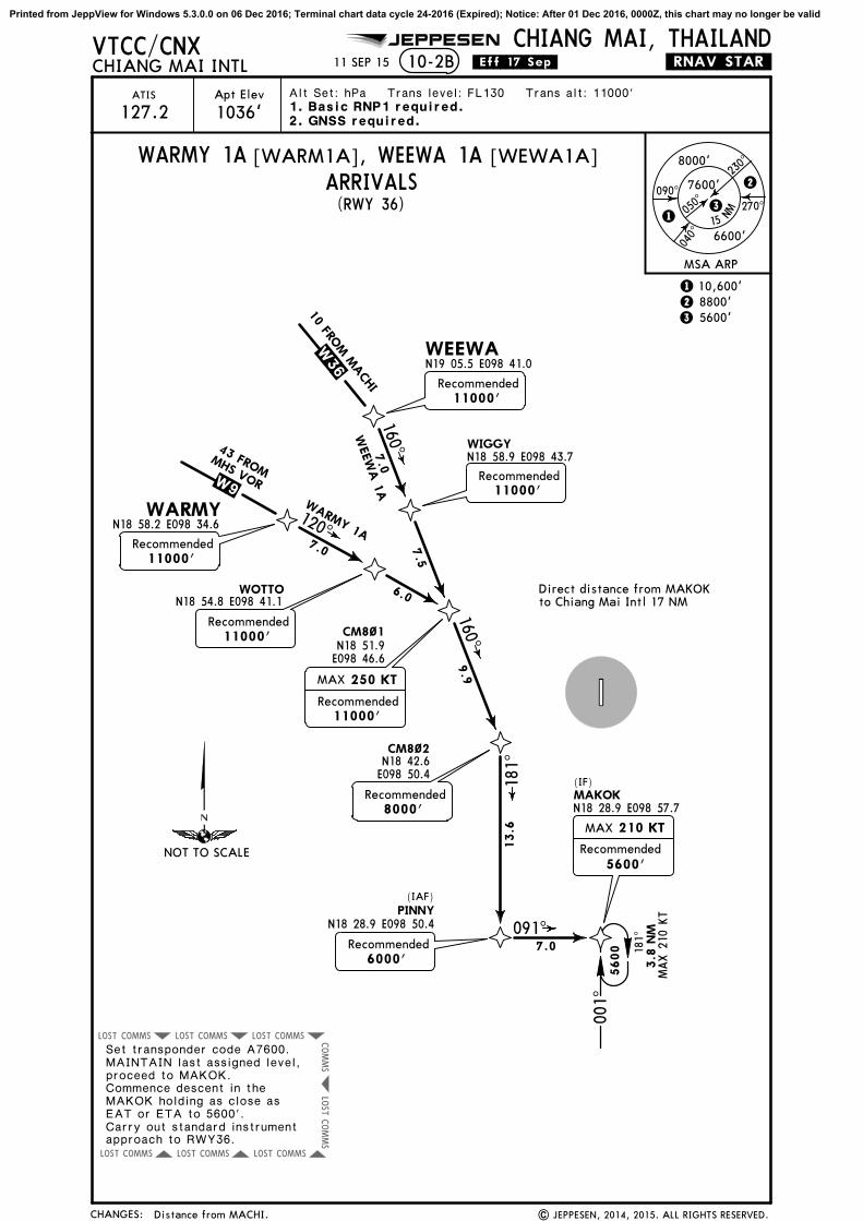
PINNYN18 28.9 E098 50.4
CM8~2
CM8~1
WOTTON18 54.8 E098 41.1
WARMYN18 58.2 E098 34.6
WIGGYN18 58.9 E098 43.7
WEEWAN19 05.5 E098 41.0
CHANGES:
Apt Elev
VTCC/CNX JEPPESEN
CHIANG MAI INTLCHIANG MAI, THAILAND
.RNAV.STAR.11 SEP 15
ATIS
127.2 1036'Alt Set: hPa Trans level: FL130 Trans alt: 11000'
8800'10,600'1
25600'3
(RWY 36)
10-2B
ARRIVALS
Direct distance from MAKOKto Chiang Mai Intl 17 NM
1. Basic RNP1 required.2. GNSS required.
MAKOKN18 28.9 E098 57.7
(IF)
181^
5600
001^
3.8
NM
MAX 2
10 K
T
7.0
13.6
091^
181^
(IAF)
9.9
7.5
7.0
7.0
6.0
120^
WARMY 1A
WEEW
A 1
A160^
160^
W 36
W 9
Set transponder code A7600.MAINTAIN last assigned level,proceed to MAKOK.Commence descent in theMAKOK holding as close asEAT or ETA to 5600'.Carry out standard instrumentapproach to RWY36.
230^
270^
040^
090^
6600'
8000'
MSA ARP
7600'
050^
1
2
315
NM
210 KTMAX
5600'Recommended
MHS VOR
43 FROM
N18 42.6E098 50.4
N18 51.9E098 46.6
| JEPPESEN, 2014, 2015. ALL RIGHTS RESERVED.
WARMY 1A [WARM1A], WEEWA 1A [WEWA1A]
.Eff.17.Sep.
10 FROM M
ACHI
Distance from MACHI.
NOT TO SCALE
11000'Recommended
11000'Recommended
8000'Recommended
250 KTMAX
11000'Recommended
11000'Recommended
11000'Recommended
6000'Recommended
Printed from JeppView for Windows 5.3.0.0 on 06 Dec 2016; Terminal chart data cycle 24-2016 (Expired); Notice: After 01 Dec 2016, 0000Z, this chart may no longer be valid

.SID.
150^
7000' 7800'
9600' 6600'
MSACMA VOR
KEDO
B 1
B
KEDOB 1
A
090^ 270^
180^
360^
7000' 7800'
9600' 6600'
MSACMA VOR
CTR 1
BCTR 1
A
090^ 270^
180^
360^
21 SEP 07
CHANGES:
TRANS ALT: 11000'
CHIANG MAI, THAILANDCHIANG MAI INTL
TRANS LEVEL: FL 130
10-3
| JEPPESEN SANDERSON, INC., 1993, 2007. ALL RIGHTS RESERVED.CHANGES:
JEPPESEN
At or above
161^
2500'
Chiang Mai Intl1036
11000'Not above
hdg
At or above2000'
180^
hdg
D38
KEDOB
then turn LEFT heading 150^ to intercept and
CHIANG MAI
116.9 CMAC M A
D
N18 46.0 E098 57.7
100Gnd speed-Kts
3.3% V/V (fpm) 251
75
334 501
150 200 250 300
1003835668
(RWY 36)
Climb runway heading until 2000' or above,
proceed on CMA R-161 not above 11000'.EXPECT RADAR control.
Climb runway heading until 2500' or above, then turn RIGHT heading 180^ to interceptand proceed on CMA R-161 not above 11000'.EXPECT RADAR control.
Rwy 36 departure requires a minimum climbgradient of:
Contact Chiang Mai Radar on 129.6 after take-off.
(RWY 18)
(RWY 36)
KEDOB ONE ALFA (KEDOB 1A)
KEDOB ONE BRAVO (KEDOB 1B)
NOT TO SCALEN18 09.7 E099 10.1
(RWY 18)
116.9 CMACHIANG MAI
C M A
D
At or above
N18 46.0 E098 57.7
036^
11000'
Chiang Mai Intl1036
Not above
D88 CMA
060^hdg
At or above2500'
010^
hdg
Gnd speed-Kts
3.3% V/V (fpm) 251
75 100
334 501
150 200
668 835
250 300
1003
(RWY 18)
(RWY 36)
CHIANG RAI ONE BRAVO (CTR 1B)
116.5 CTRCHIANG RAI
C T R
D
N19 56.9 E099 53.0
Climb runway heading until 2500' or above, then turnRIGHT heading 060^ to intercept and proceed on
Contact Chiang Mai Radar on 129.6 after take-off.Rwy 36 departure requires a minimum climb gradient of:
CHIANG RAI ONE ALFA (CTR 1A)(RWY 18)
Climb runway heading until 2000' or above, then turn LEFTheading 010^ to intercept and proceed on CMA R-036 notabove 11000'. EXPECT RADAR control.
(RWY 36)
CMA R-036 not above 11000'.EXPECT RADAR control.
NOT TO SCALE
2000'
MSA.
CHIANG RAI ONE ALFA (CTR 1A) DEPARTURE
CHIANG RAI ONE BRAVO (CTR 1B) DEPARTURE
.W 2 0.KEDOB ONE ALFA (KEDOB 1A) DEPARTURE
KEDOB ONE BRAVO (KEDOB 1B) DEPARTURE
.A 464.
Printed from JeppView for Windows 5.3.0.0 on 06 Dec 2016; Terminal chart data cycle 24-2016 (Expired); Notice: After 01 Dec 2016, 0000Z, this chart may no longer be valid

.SID.
090^ 270^
180^
360^
7000' 7800'
9600' 6600'
MSACMA VOR
090^ 270^
180^
360^
7000' 7800'
9600' 6600'MSA
CMA VOR
PSL 1
BPSL 1
A
MHS 1
BM
HS 1
A
21 SEP 07
CHANGES:
TRANS ALT: 11000'
CHIANG MAI, THAILANDCHIANG MAI INTL
TRANS LEVEL: FL 130
10-3A
| JEPPESEN SANDERSON, INC., 1993, 2007. ALL RIGHTS RESERVED.
NOT TO SCALE
NOT TO SCALE
At or above3500'
(RWY 18)
(RWY 36)
(RWY 36)
At or above2000'
147^
11000'Not above
110^ hdg
CHIANG MAI
C M A
116.9 CMAIntl1036
Chiang Mai
114.1 PSLPHITSANULOK
P S L
D
N16 46.1 E100 17.5D142 CMA
hdg2500'At or above
170^
1003
300
D
N18 46.0 E098 57.7
Contact Chiang Mai Radar on 129.6 after take-off.Rwy 36 departure requires a minimum climb gradient of:
Gnd speed-Kts
3.3% V/V (fpm)
EXPECT RADAR control.
75
251 334
100 150
501 668
200 250
835
PHITSANULOK ONE ALFA (PSL 1A)
PHITSANULOK ONE BRAVO (PSL 1B)
(RWY 18)
Contact Chiang Mai Radar on 129.6 after take-off.
299^
116.9 CMACHIANG MAI
D
2500'
At or above
hdg
MAE HONG SON ONE BRAVO (MHS 1B)
Climb runway heading until 2500' or above, then turn RIGHT heading180^ to cross CMA R-130 not below 6500', turn RIGHT heading 310^
RADAR control.
MAE HONG SON ONE ALFA (MHS 1A)
300
1003835
250200
668501
150100
334251
75Gnd speed-Kts
3.3% V/V (fpm)
Climb runway heading until 3500' or above, then turn RIGHT heading320^ to cross CMA R-255 not below 6500', then intercept andproceed on CMA R-299 not above 11000'. EXPECT RADAR control.
N19 19.2 E097 54.7D68 CMA
M H S
115.5 MHSMAE HONG SON
D
Not above11000'
hdg
320^
Not below6500'
255^1036Intl
Chiang Mai
N18 46.0 E098 57.7C M A
180^
130^310^hdg
Not below6500'
Rwy 36 departure requires a minimum climb gradient of:
(RWY 18)
(RWY 36)
(RWY 18)Climb runway heading until 2000' or above,then turn LEFT heading 110^ to interceptand proceed on CMA R-147 not above 11000'.
(RWY 36)Climb runway heading until 2500' orabove, then turn RIGHT heading170^ to intercept and proceed onCMA R-147 not above 11000'. EXPECT
RADAR control.
JEPPESEN
to intercept and proceed on CMA R-299 not above 11000'. EXPECT
MSA.
MAE HONG SON ONE ALFA (MHS 1A) DEPARTURE
MAE HONG SON ONE BRAVO (MHS 1B) DEPARTURE
.W 9.
PHITSANULOK ONE ALFA (PSL 1A) DEPARTURE
PHITSANULOK ONE BRAVO (PSL 1B) DEPARTURE
.W 9.
Printed from JeppView for Windows 5.3.0.0 on 06 Dec 2016; Terminal chart data cycle 24-2016 (Expired); Notice: After 01 Dec 2016, 0000Z, this chart may no longer be valid
.SID.
PR 1
BPR 1
A
090^ 270^
180^
360^
7000' 7800'
9600' 6600'
MSACMA VOR
21 SEP 07
CHANGES:
TRANS ALT: 11000'
CHIANG MAI, THAILANDCHIANG MAI INTL
TRANS LEVEL: FL 130
10-3B
| JEPPESEN SANDERSON, INC., 1993, 2007. ALL RIGHTS RESERVED.
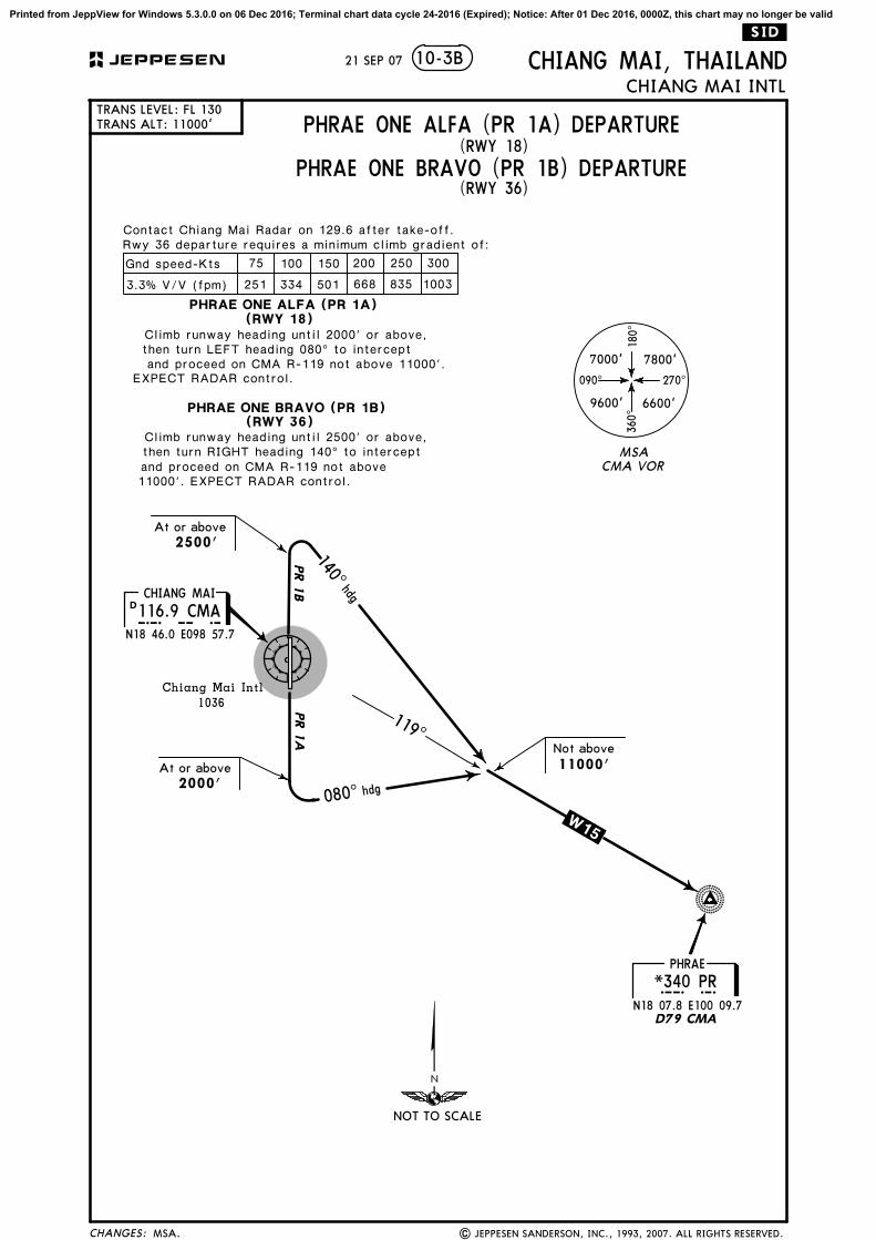
D
At or above
At or above2500'
119^
2000'
Chiang Mai Intl
1036
116.9 CMACHIANG MAI
C M A
N18 46.0 E098 57.7
11000'
N18 07.8 E100 09.7
PHRAE
P R
D79 CMA
Not above
*340 PR
140^hdg
080^ hdg
NOT TO SCALE
and proceed on CMA R-119 not above 11000'.EXPECT RADAR control.
11000'. EXPECT RADAR control.
100Gnd speed-Kts
3.3% V/V (fpm) 251
75
334 501
150 200 250 300
1003835668
Rwy 36 departure requires a minimum climb gradient of:
PHRAE ONE ALFA (PR 1A)
PHRAE ONE BRAVO (PR 1B)
then turn LEFT heading 080^ to interceptClimb runway heading until 2000' or above,
Climb runway heading until 2500' or above, then turn RIGHT heading 140^ to interceptand proceed on CMA R-119 not above
(RWY 18)
(RWY 36)
Contact Chiang Mai Radar on 129.6 after take-off.
(RWY 18)
(RWY 36)
MSA.
PHRAE ONE ALFA (PR 1A) DEPARTURE
PHRAE ONE BRAVO (PR 1B) DEPARTURE
.W 15.
JEPPESEN
Printed from JeppView for Windows 5.3.0.0 on 06 Dec 2016; Terminal chart data cycle 24-2016 (Expired); Notice: After 01 Dec 2016, 0000Z, this chart may no longer be valid
.SID.
090^ 270^
180^
360^
7000' 7800'
9600' 6600'
MSACMA VOR
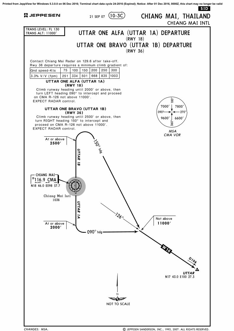
UTTA
R 1
BUTTA
R 1
A
21 SEP 07
CHANGES:
TRANS ALT: 11000'
CHIANG MAI, THAILANDCHIANG MAI INTL
TRANS LEVEL: FL 130
10-3C
| JEPPESEN SANDERSON, INC., 1993, 2007. ALL RIGHTS RESERVED.
NOT TO SCALE
(RWY 18)
(RWY 36)
Contact Chiang Mai Radar on 129.6 after take-off.Rwy 36 departure requires a minimum climb gradient of:
11000'
At or above
116.9 CMACHIANG MAI
2500'
At or above2000'
Chiang Mai Intl
1036
126^
C M A
D
N18 46.0 E098 57.7
Not above
150^hdg
090^ hdg
EXPECT RADAR control.
100Gnd speed-Kts
3.3% V/V (fpm) 251
75
334 501
150 200 250 300
1003835668
UTTARN17 43.0 E100 27.3
D106
(RWY 18)
(RWY 36)
Climb runway heading until 2000' or above, thenturn LEFT heading 090^ to intercept and proceed
on CMA R-126 not above 11000'.
Climb runway heading until 2500' or above, thenturn RIGHT heading 150^ to intercept andproceed on CMA R-126 not above 11000'.
EXPECT RADAR control.
UTTAR ONE ALFA (UTTAR 1A)
UTTAR ONE BRAVO (UTTAR 1B)
MSA.
UTTAR ONE ALFA (UTTAR 1A) DEPARTURE
UTTAR ONE BRAVO (UTTAR 1B) DEPARTURE
.W 16.
JEPPESEN
Printed from JeppView for Windows 5.3.0.0 on 06 Dec 2016; Terminal chart data cycle 24-2016 (Expired); Notice: After 01 Dec 2016, 0000Z, this chart may no longer be valid

COMMSLOST COMMSLOST COMMSLOST
COMMS
LOST
COMMS LOSTCOMMS LOSTCOMMS LOST
COMMS
LOST
ANYARN18 23.4 E099 30.0
EMMET
NUNWAN19 06.2 E099 13.3
R 2 07 W 1 2
W 20
66NAN
VORDME
A 581 63
CHANGES:
VTCC/CNX JEPPESEN
| JEPPESEN, 2014. ALL RIGHTS RESERVED.
CHIANG MAI INTLCHIANG MAI, THAILAND
25 APR 14 .Eff.1.May.
(RWY 36)
New procedures at this airport.
10-3D
Set transponder code 7600.Proceed on SID, comply with lastassigned level or MFA until nextcompulsory reporting point, thenclimb to flight plan cruising level.
Required minimum climb gradient of 5.0%until passing FL150.
5.0% V/V (fpm) 380 506 760 1013 1266 1519
Gnd speed-KT 75 100 150 200 250 300
Close-in obstacle
RWY 36: Terrain 60' height,74m from departure end.
230^
270^
040^
090^
8800'
6600'
10,600'
8000'
MSA ARP
7600'
050^
1
12
2
315 NM
ARP
5600'3
Apt Elev
1036'
Trans level: FL130 Trans alt: 11000'
.RNAV.SID.
1. RNAV 1 required. 2. GNSS or DME/DME/IRU required.
DEPARTURES
3. RADAR required.4. If unable to comply with SID or climb gradient, advise
CHIANG MAI Approach on 129.6.
ANYAR 1N [ANYA1N], EASEE 1N [EASE1N],
EMMET 1N [EMET1N], NUNWA 1N [NUNW1N]
NIMMAN18 50.9 E098 57.8
NOBLEN18 50.8 E099 13.1
CM1~1N18 39.4 E099 13.1
ADORNN18 25.2 E099 13.0
4.0
001^
14.1
11.4
181^
EASEEN18 47.0 E099 37.7
EXTARN18 46.9 E099 30.3
CM3~1N18 39.6 E099 22.7
CM3~2N18 31.9 E099 29.2
At or aboveFL140
097^
142^
16.2
5.5
9.9
W 16 68
W 15 40PAE VORDME
At or aboveFL150
ANYAR 1N
EMMET 1
N
TO UTTA
R
TO
N17 43.1 E100 27.1
N18 08.0 E100 10.0
14.4
104^
089^7.0
16.8
EASEE 1N
260 KTMAX
At or above6500'
11000'At or below
11000'At or below
TO
NUNWA 1N
21.1
045^
TO
CTR
VORD
ME
N19 56.9 E099 53.0
Between8000' & 11000'
N18 27.6 E099 32.8
At or aboveFL150
At or aboveFL140
11000'At or below
11000'At or below
200 KTMAX
At or above2000'
N18 48.5E100 47.0
NOT TO SCALE
Printed from JeppView for Windows 5.3.0.0 on 06 Dec 2016; Terminal chart data cycle 24-2016 (Expired); Notice: After 01 Dec 2016, 0000Z, this chart may no longer be valid

COMMSLOST COMMSLOST COMMSLOST
COMMS
LOST
COMMS LOSTCOMMS LOSTCOMMS LOST
COMMS
LOST
PANTAN18 13.9 E099 19.3
ALLAY
ZARDY
ZUGAR
CHANGES:
VTCC/CNX JEPPESEN
| JEPPESEN, 2014. ALL RIGHTS RESERVED.
CHIANG MAI INTLCHIANG MAI, THAILAND
25 APR 14 .Eff.1.May.
(RWY 36)
New procedures at this airport.
10-3E
W 7
A 581
A 464
W 9
39
88
MST V
ORDM
E51
42
N18 08.5E098 50.0
NIMMAN18 50.9 E098 57.8 NOBLE
N18 50.8 E099 13.1
CM1~1N18 39.4 E099 13.1
ADORNN18 25.2 E099 13.0
4.0
001^
200 KTMAX
At or above2000'
At or aboveFL150
N18 08.2 E098 51.8
At or aboveFL150
N18 09.7E099 10.1
At or aboveFL150
At or aboveFL150
PANTA 1
N
ALLA
Y 1
N
ZUGAR 1NZA
RDY
1N27
.5
26.3 1
5.7
12.8
234^
231^
191^
153^
At or aboveFL140
14.1
11.4
181^
11000'At or below
260 KTMAX
At or above6500'
Set transponder code 7600.Proceed on SID, comply with lastassigned level or MFA until nextcompulsory reporting point, thenclimb to flight plan cruising level.
Required minimum climb gradient of 5.0%until passing FL150.
5.0% V/V (fpm) 380 506 760 1013 1266 1519
Gnd speed-KT 75 100 150 200 250 300Close-in obstacle
RWY 36: Terrain 60' height,74m from departure end.
230^
270^
040^
090^
8800'
6600'
10,600'
8000'
MSA ARP
7600'
050^
1
12
2
315 NM
ARP
5600'3
Apt Elev
1036'
Trans level: FL130 Trans alt: 11000'
.RNAV.SID.
1. RNAV 1 required. 2. GNSS or DME/DME/IRU required.
PANTA 1N [PANT1N],[ALAY1N],ALLAY 1NZARDY 1N [ZARD1N], ZUGAR 1N [ZUGA1N]
DEPARTURES
3. RADAR required.4. If unable to comply with SID or climb gradient, advise
CHIANG MAI Approach on 129.6.
N17
29.1
E098
45.8
TO
TA
TEL
TO
N16
41.9
E098
32.5 N
17 29.3 E099 24.0TO
TO
PA
S
TO S
ARIM
N17 30.5 E099 47.6
Y 7
NOT TO SCALE
Printed from JeppView for Windows 5.3.0.0 on 06 Dec 2016; Terminal chart data cycle 24-2016 (Expired); Notice: After 01 Dec 2016, 0000Z, this chart may no longer be valid

COMMSLOST COMMSLOST COMMSLOST
COMMS
LOST
COMMS LOSTCOMMS LOSTCOMMS LOST
COMMS
LOST
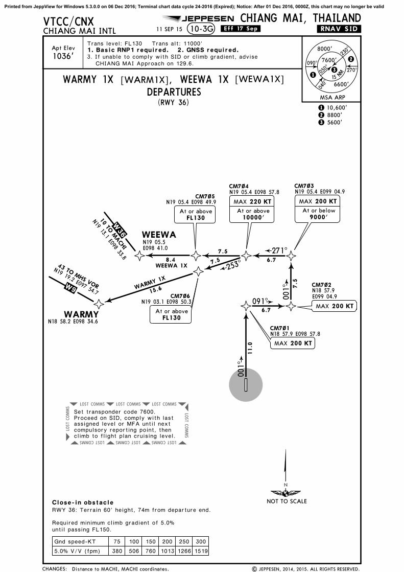
WARMYN18 58.2 E098 34.6
WEEWA
CHANGES:
Apt Elev
VTCC/CNX JEPPESEN
CHIANG MAI INTLCHIANG MAI, THAILAND
11 SEP 15
1036' 230^
270^
040^
090^
8800'
6600'
10,600'
8000'
MSA ARP
7600'
050^
1
12
2
3
5600'3
(RWY 36)
10-3F
1. Basic RNP1 required.
WARMY 1N [WARM1N], WEEWA 1N [WEWA1N]
W 36
W 9
WIZARN18 57.8 E098 42.6
.RNAV.SID.
Trans level: FL130 Trans alt: 11000'
DEPARTURES
10.0
001^
2. GNSS required.
CHIANG MAI Approach on 129.6.3. If unable to comply with SID or climb gradient, advise
RWY 36: Terrain 60' height, 74m from departure end.
Close-in obstacle
N19 19.2 E097 54.7N19 13.1 E098 33.8
WARMY 1N: Required minimum climb gradientof 5.5% until passing FL150.WEEWA 1N: Required minimum climb gradientof 5.0% until passing FL150.
5.5% V/V (fpm) 418 557 835 1114 1392 1671
5.0% V/V (fpm) 380 506 760 1013 1266 1519
Gnd speed-KT 75 100 150 200 250 300
Set transponder code 7600.Proceed on SID, comply with lastassigned level or MFA until nextcompulsory reporting point, thenclimb to flight plan cruising level.
At or above4000'
CM9~1N18 56.9 E098 57.8
7.614.4
18.0
274^
299^
WEEWA 1N
WARMY 1N
Between9000' & 10000'
N19 05.5 E098 41.0
At or above9000'
Between9000' & 10000'
.Eff.17.Sep.
10 TO M
ACHI
43 TO MHS VOR
Distance to MACHI, MACHI coordinates. | JEPPESEN, 2014, 2015. ALL RIGHTS RESERVED.
15 NM
NOT TO SCALE
Printed from JeppView for Windows 5.3.0.0 on 06 Dec 2016; Terminal chart data cycle 24-2016 (Expired); Notice: After 01 Dec 2016, 0000Z, this chart may no longer be valid
COMMSLOST COMMSLOST COMMSLOST
COMMS
LOST
COMMS LOSTCOMMS LOSTCOMMS LOST
COMMS
LOST
WARMYN18 58.2 E098 34.6
WEEWA
CHANGES:
Apt Elev
VTCC/CNX JEPPESEN
CHIANG MAI INTLCHIANG MAI, THAILAND
11 SEP 15
1036' 230^
270^
040^
090^
8800'
6600'
10,600'
8000'
MSA ARP
7600'
050^
1
12
2
315 N
M
5600'3
(RWY 36)
10-3G
1. Basic RNP1 required.
WARMY 1X [WARM1X], WEEWA 1X [WEWA1X]
W 36 W 9
CM7~1N18 57.9 E098 57.8
CM7~2
CM7~3N19 05.4 E099 04.9
CM7~4N19 05.4 E098 57.8
CM7~5N19 05.4 E098 49.9
CM7~6N19 03.1 E098 50.3
.RNAV.SID.
Trans level: FL130 Trans alt: 11000'
DEPARTURES
N19 05.5E098 41.0
11.0
6.7
6.7
7.5
7.5
8.4 7.5
001^
001^
091^
271^
253^
15.6WARMY 1X
WEEWA 1X
At or aboveFL130
At or aboveFL130
220 KTMAX
At or above10000'
MAX 200 KT
N18 57.9E099 04.9
MAX 200 KT
Required minimum climb gradient of 5.0%until passing FL150.
5.0% V/V (fpm) 380 506 760 1013 1266 1519
Gnd speed-KT 75 100 150 200 250 300
2. GNSS required.
CHIANG MAI Approach on 129.6.3. If unable to comply with SID or climb gradient, advise
RWY 36: Terrain 60' height, 74m from departure end.
Close-in obstacle
N19 19.2 E097 54.7
N19 13.1 E098 33.8
200 KTMAX
At or below9000'
Set transponder code 7600.Proceed on SID, comply with lastassigned level or MFA until nextcompulsory reporting point, thenclimb to flight plan cruising level.
.Eff.17.Sep.
10 TO M
ACHI
43 TO MHS VOR
| JEPPESEN, 2014, 2015. ALL RIGHTS RESERVED.Distance to MACHI, MACHI coordinates.
NOT TO SCALE
Printed from JeppView for Windows 5.3.0.0 on 06 Dec 2016; Terminal chart data cycle 24-2016 (Expired); Notice: After 01 Dec 2016, 0000Z, this chart may no longer be valid
JEPPESEN
2 JAN 15
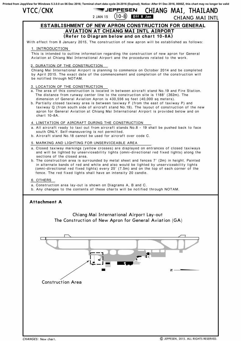
With effect from 8 January 2015, The construction of new apron will be established as follows:
1. INTRODUCTION
2. DURATION OF THE CONSTRUCTION
3. LOCATION OF THE CONSTRUCTION
b. Partially closed taxiway area is between taxiway F (from the east of taxiway P) and
4. LIMITATION OF AIRCRAFT DURING THE CONSTRUCTION
south ONLY. Self-maneuvering is not permitted.b. Aircraft stand No.18 cannot be used for aircraft over code C.
a. The area of this construction is located in between aircraft stand No.19 and Fire Station.The distance from runway center line to the construction site is 1188' (362m). Thedimension of General Aviation Apron is 430,556 sq feet (40,000 sq meters).
5. MARKING AND LIGHTING FOR UNSERVICEABLE AREA
a. Closed taxiway markings (yellow crosses) are displayed on entrances of closed taxiways
sections of the closed area.b. The construction area is surrounded by metal sheet and fences 7' (2m) in height. Painted
in alternate bands of red and white and also would be lighted by unserviceability lights
fence. The red fixed lights shall have an intensity 20 candle.
6. OTHERS
b. Any changes to the contents of these charts will be notified through NOTAM.
Attachment A
Chiang Mai International Airport Lay-out
Construction Area
The Construction of New Apron for General Aviation (GA)
be notified through NOTAM.by April 2015. The exact date of the commencement and completion of the construction willChiang Mai International Airport is planning to commence on October 2014 and be completed
chart 10-8A.apron for General Aviation at Chiang Mai International Airport is provided below and ontaxiway Q (from south side of aircraft stand No.19). The layout of construction of the new
a. All aircraft ready to taxi out from aircraft stands No.8 - 19 shall be pushed back to face
and will be lighted by unserviceability lights (omni-directional red fixed lights) along the
(omni-directional red fixed lights) every 25' (7.5m) and on the top of each corner of the
a. Construction area lay-out is shown on Diagrams A, B and C.
.Eff.8.Jan.
CHANGES:
10-8VTCC/CNX CHIANG MAI, THAILAND
CHIANG MAI INTL
New chart. | JEPPESEN, 2015. ALL RIGHTS RESERVED.
AVIATION AT CHIANG MAI INTL AIRPORT
This is intended to outline information regarding the construction of new apron for General
ESTABLISHMENT OF NEW APRON CONSTRUCTION FOR GENERAL
(Refer to Diagram below and on chart 10-8A)
Aviation at Chiang Mai International Airport and the procedures related to the work.
Printed from JeppView for Windows 5.3.0.0 on 06 Dec 2016; Terminal chart data cycle 24-2016 (Expired); Notice: After 01 Dec 2016, 0000Z, this chart may no longer be valid

JEPPESEN
2 JAN 15
1314 121918 17 1615
TWY P
TWY F TWY P6Closed TWY Q
(South of stand 19)
Closed TWY F(East of TWY P)
CONCRETE PLANT& SITEOFFICE
TWY Q
LEGEND
CLOSED TAXI MARKINGEMERGENCY ACCESS ROADAIRSIDE ACCESS POINT
CONSTRUCTION AREA BOUNDARY
FENCE
FIRESTATION
CONSTRUCTION AREA
CLOSED TAXIWAY
TWY Q
TWY P
TWY P6 TWY P5
Attachment C
Closed Taxiway between TWY F (east of TWY P) and TWY Q
(south side of aircraft stand No.19)
LEGEND
CLOSED TAXI MARKING
1918 17 1615 1314 12
Diagram B
TWY F
TWYF
.Eff.8.Jan.
197' 60m
108' 33m
75' 23m
CHANGES:
VTCC/CNX10-8A
CHIANG MAI, THAILANDCHIANG MAI INTL
New chart. | JEPPESEN, 2015. ALL RIGHTS RESERVED.
Printed from JeppView for Windows 5.3.0.0 on 06 Dec 2016; Terminal chart data cycle 24-2016 (Expired); Notice: After 01 Dec 2016, 0000Z, this chart may no longer be valid

VT(R)-5
LVP must be in ForceRCLM (DAY only) RCLM (DAY only)
or RL or RL
ATIS CHIANG MAI Ground Tower
127.2 121.9 118.1
Apt ElevCHIANG MAI, THAILAND
CHIANG MAI INTLN18 46.3 E098 57.810-91036'
236' AGL
ARP
All Rwys
Eng
3 & 4Eng
TAKE-OFF
All Rwys
AIR CARRIER (FAR 121)
400m400m
ABCD
2
Adequate Vis Ref
AIR CARRIER (JAA)
250m
300m
18-45 18-45
18-46
18-47 18-47
98-57
98-57
98-58
98-58
98-59
98-59
VTCC/CNX
01^W
| JEPPESEN, 2002, 2016. ALL RIGHTS RESERVED.
JEPPESEN
FOR PARKING POSITIONS SEE 10-9A
-- Aircraft ready to taxi out shall prepare their own tow bars.
-- All aircraft operating outside of specified airport hours of operation shall be responsible for all expensesincurred.
NOTE: Aircraft below code letter "C" are allowed to self-maneuver but first must inform Chiang Mai Ground Control. Also, aircraft below code letter "C" must be correctly bonded and use correct grounding procedures.
29 JUL 16
Taxiway F restriction removed, rwy bearings, glideslope distance.
RWY18
36 RVR 9089' 2770m
WIDTH
45m148'
TAKE-OFFLANDING BEYOND
USABLE LENGTHS
Glide SlopeThreshold
CHANGES:
ADDITIONAL RUNWAY INFORMATIONADDITIONAL RUNWAY INFORMATION
North Apron
Control Tower
South Apron
Elev 1007'
100mStopway328'
VOR
36360^
H
3400m11,155'
G
P
A
F
P
P6
P
P5
C
B
180^18
P
E
P
Q
Cargo Terminal
5000
1500
1000
1000500
0
0
Feet
Meters
2000 3000 4000
P4
P3
P2
P1D
A
F
3100m10,171'
Q
3100m10,171'
Elev 1036'
Bldg Area
All aircraft wishing to operate at Chiang Mai Intl Apt shall adhere to the following procedures:
-- Nose-in parking is applicable to all aircraft.
-- All flights, including those using Chiang Mai as an alternate airport, shall have a handling agent at Chiang Mai airport.-- The Airport Authority must be informed and approval must be received at least one hour before any operations.
CAUTION: High terrain west of airport.
RL SSALF PAPI-B (angle 3.0^)RL SSALF PAPI-B (angle 3.0^)
Passenger Terminal
Printed from JeppView for Windows 5.3.0.0 on 06 Dec 2016; Terminal chart data cycle 24-2016 (Expired); Notice: After 01 Dec 2016, 0000Z, this chart may no longer be valid

18-46.0
18-46.1
18-46.2
98-57.9 98-58.0
18-46.3
1
2
3A3
P5
PARKING STAND COORDINATES
STAND No. COORDINATES
RWY 18-36
CARGOTERMINAL
NORTHAPRON
SOUTHAPRON
VTCC/CNX CHIANG MAI, THAILANDCHIANG MAI INTL10-9A
18-45.9
18-46.4
98-57.8 98-58.1 98-58.298-57.7
JEPPESEN
| JEPPESEN, 2008, 2014. ALL RIGHTS RESERVED.
CONTROLTOWER
None.
Stands 2 thru 19 available with fuel hydrant system.
Stands 3, 4, 5, 6, 7, 8 available with safe gatedocking system.
PASSENGER TERMINAL
29 JUL 16
10
14
N18 46.0 E098 58.0N18 46.1 E098 58.0N18 46.1 E098 58.1N18 46.2 E098 58.0N18 46.3 E098 58.0
5, 67
1
8
13
11
9
12
15
7
4
5
6
16
P
P6
P
E
Q
P4
171819
Q
Q
P
N18 45.9 E098 58.0
CHANGES:
8 thru 15
16 thru 19
2, 3, 3A, 4
Printed from JeppView for Windows 5.3.0.0 on 06 Dec 2016; Terminal chart data cycle 24-2016 (Expired); Notice: After 01 Dec 2016, 0000Z, this chart may no longer be valid

VTCC/CNX28 AUG 15 10-9B
1. INTRODUCTION
1.2 The system enables the pilots seated on the left of the cockpit to positionhis aircraft on the correct stand centerline and stop position.
SAFEGATE DOCKING SYSTEM
2. PILOT OPERATING INSTRUCTION2.1 Safety Procedure
a.) General warningThe DGS system has a built-in error detection program to inform theaircraft pilot of impending dangers during the docking procedure.If the pilot is unsure of the information, being shown on the DGS
information for clearance.b.) Item to check before entering the stand area
Warning: The pilot shall not enter the stand area, unless the dockingsystem first is showing the vertical running arrows. The pilot must notproceed beyond the bridge, unless these arrows have been supersededby the closing rate bar.
Warning: The pilot shall not enter the stand area, unless the aircraft
other information, such as 'door 2', shall also be checked.c.) The SBU message
The message STOP SBU means that docking has been interrupted andhas to be resumed only by manual guidance. Do not try to resumedocking without manual guidance.
2.2 START OF DOCKINGThe system is started by pressing one of the aircraft typebuttons on the operator panel. When the button has been
2.3 CAPTUREThe floating arrows indicate that the system is activatedand in capture mode, searching for an approaching aircraft.It shall be checked that the correct aircraft type is displayed.The lead-in line shall be followed.The pilot must not proceed beyond the bridge, unless thearrows have been superseded by closing rate bar.
pressed, WAIT will be displayed.
type displayed is equal to the approaching aircraft/The Correctness of
display unit, he must immediately stop the aircraft and obtain further
JEPPESEN CHIANG MAI, THAILANDCHIANG MAI INTL
-IN SYSTEM AT CHIANG MAI INTL AIRPORT
and 8.
| JEPPESEN, 2011, 2015. ALL RIGHTS RESERVED.
1.1 The SAFEGATE Docking System-in system is installed at bays 3, 4, 5, 6, 7
Docking System bays.
WAIT
B747
CHANGES:
Printed from JeppView for Windows 5.3.0.0 on 06 Dec 2016; Terminal chart data cycle 24-2016 (Expired); Notice: After 01 Dec 2016, 0000Z, this chart may no longer be valid

VTCC/CNX28 AUG 15 10-9C
| JEPPESEN, 2011. ALL RIGHTS RESERVED.
2.4 TRACKING
2.5 CLOSING RATE
When the aircraft has been caught by the laser, the floatingarrow is replaced by the yellow centerline indicator.
A flashing red arrow indicates the direction to turn.
The vertical yellow arrow shows position in relation to thecenterline. This indicator gives correct position and azimuthguidance.
Display of digital countdown will start when the aircraft is20 meters from stop position.
When the aircraft is less than 12 meters from the stopposition, the closing rate is indicated by turning off one rowof the centerline symbol per 0.5 meters, covered by the
remains to stop.aircraft. Thus, when the last row is turned off, 0.5 meters
2.6 ALIGNED TO CENTER
2.7 SLOW DOWNIf the aircraft is approaching faster than the acceptedspeed, the system will show SLOW DOWN as a warningto the pilot.
The aircraft is eight meters from the stop position. Theabsence of any direction arrow indicates an aircraft onthe centerline.
The aircraft is four meters from the stop position. The2.8 AZIMUTH GUIDANCE
2.9 STOP POSITION REACHED
yellow arrow indicates an aircraft to the right of the
direction to turn.
When the correct stop-position is reached, the display willshow STOP and red lights will be lit.
2.10 DOCKING COMPLETE
2.11 OVERSHOOT
When the aircraft has parked, OK will be displayed.
If the aircraft overshoots the stop-position, TOO FARwill be displayed.
2.12 STOP SHORTIf the aircraft is found standing still but has not reached the intended stop position, the message STOP
centerline, and the red flashing arrow indicates the
JEPPESEN CHIANG MAI, THAILANDCHIANG MAI INTL
OK will be shown after a while.
None.
B747
B74710.0M
B747
SLOW
8.0M
DOWN
B747
STOP
4.0M
TOO
OK
FAR
OKSTOP
CHANGES:
Printed from JeppView for Windows 5.3.0.0 on 06 Dec 2016; Terminal chart data cycle 24-2016 (Expired); Notice: After 01 Dec 2016, 0000Z, this chart may no longer be valid
JEPPESENVTCC/CNX15 APR 11 10-9D
| JEPPESEN, 2011. ALL RIGHTS RESERVED.New procedure.
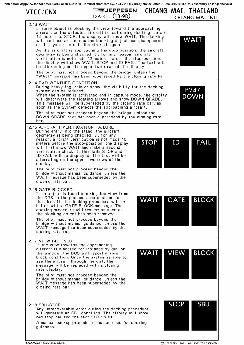
2.13 WAITIf some object is blocking the view toward the approachingaircraft or the detected aircraft is lost during docking, before12 meters to STOP, the display will show WAIT. The dockingwill continue as soon as the blocking object has disappearedor the system detects the aircraft again.
As the aircraft is approaching the stop position, the aircraftgeometry is being checked. If, for any reason, aircraftverification is not made 12 meters before the stop-position,the display will show WAIT, STOP and ID FAIL. The text willbe alternating on the upper two rows of the display.
The pilot must not proceed beyond the bridge, unless the"WAIT" message has been superseded by the closing rate bar.
2.14 BAD WEATHER CONDITIONDuring heavy fog, rain or snow, the visibility for the dockingsystem can be reduced.When the system is activated and in capture mode, the displaywill deactivate the floating arrows and show DOWN GRADE.This message will be superseded by the closing rate bar, assoon as the System detects the approaching aircraft.
The pilot must not proceed beyond the bridge, unless theDOWN GRADE text has been superseded by the closing ratebar.
2.15 AIRCRAFT VERIFICATION FAILUREDuring entry into the stand, the aircraftgeometry is being checked. If, for anyreason, aircraft verification is not made 40meters before the stop-position, the displaywill first show WAIT and make a secondverification check. If this fails STOP andID FAIL will be displayed. The text will bealternating on the upper two rows of thedisplay.
The pilot must not proceed beyond thebridge without manual guidance, unless theWAIT message has been superseded by theclosing rate bar.
2.16 GATE BLOCKEDIf an object is found blocking the view fromthe DGS to the planned stop position forthe aircraft, the docking procedure will behalted with a GATE BLOCK message. Thedocking procedure will resume as soon as
The pilot must not proceed beyond thebridge without manual guidance, unless theWAIT message has been superseded by theclosing rate bar.
2.17 VIEW BLOCKED
The pilot must not proceed beyond thebridge without manual guidance, unless theWAIT message has been superseded by theclosing rate bar.
If the view towards the approachingaircraft is hindered for instance by dirt onthe window, the DGS will report a viewblock condition. Once the system is able tosee the aircraft through the dirt, themessage will be replaced with a closingrate display.
2.18 SBU-STOPAny unrecoverable error during the docking procedurewill generate an SBU condition. The display will showred stop bar and the text STOP SBU.
A manual backup procedure must be used for dockingguidance.
the blocking object has been removed.
CHIANG MAI, THAILANDCHIANG MAI INTL
WAIT
B747DOWN
STOP FAILID
WAIT GATE BLOCK
WAIT VIEW BLOCK
STOP SBU
CHANGES:
Printed from JeppView for Windows 5.3.0.0 on 06 Dec 2016; Terminal chart data cycle 24-2016 (Expired); Notice: After 01 Dec 2016, 0000Z, this chart may no longer be valid

JEPPESENVTCC/CNX15 APR 11 10-9E
| JEPPESEN, 2011. ALL RIGHTS RESERVED.New procedure.
2.19 TOO FASTIf the aircraft approaches with a speedhigher than the docking system can handle,the message STOP (with red squares) andTOO FAST will be displayed.
The docking system must be re-started ordocking procedure completed by manualguidance.
2.20 EMERGENCY STOPWhen the emergency stop button is pressed, STOP isdisplayed.
2.21 CHOCKS ONCHOCK ON will be displayed, when the ground staff has putthe chocks in front of the nose wheel and pressed the"Chocks On" button on the operator panel.
2.22 ERRORIf a system error occurs, the message ERROR is displayedwith an error code. The code is used for maintenancepurposes and explained elsewhere.
2.23 SYSTEM BREAKDOWNIn case of a severe system failure, the display will go black,except for a red stop indicator. A manual backup proceduremust be used for docking guidance.
2.24 POWER FAILUREIn case of a power failure, the display will be completely
guidance.black. A manual backup procedure must be used for docking
CHIANG MAI, THAILANDCHIANG MAI INTL
STOP
STOP FASTTOO
ERROR3
CHOCKON
CHANGES:
Printed from JeppView for Windows 5.3.0.0 on 06 Dec 2016; Terminal chart data cycle 24-2016 (Expired); Notice: After 01 Dec 2016, 0000Z, this chart may no longer be valid

JEPPESEN
| JEPPESEN, 2011. ALL RIGHTS RESERVED.
10-9F15 APR 11VTCC/CNX CHIANG MAI, THAILAND
CHIANG MAI INTL
ALLOCATION OF AIRCRAFT PARKING BAYS
All aircraft parking bays are allocated by the Ground/Apron controller with regardto the aircraft type involved and the prevailing or anticipated traffic situation.
AIRCRAFT MARSHALLING AND TOWING SERVICES
The marshalling of scheduled, non-scheduled and private aircraft into the bays,either manually or by the aid of the SAFEGATE Docking System, and the pushing out ofaircraft for departure shall be under the responsibility of the aircraft operator or it'sappointed ground handling agency.
TAXIING PROCEDURES
a. Arriving Aircraft
b. Departing Aircraft
Aircraft entering the aprons are to follow closely to the taxiway and apron center-lines so as to avoid reducing safe distances between themselves and other aircraft.
When start-up clearance is issued by ATC, aircraft are then to be pushed out ontothe apron centerline.
START-UP PROCEDURES
All IFR aircraft are to call Ground Control 5 minutes prior to start-up to requestATC clearance. Pilots are to inform Ground Control of their call sign (and proposedflight level if different from the flight plan) when making the call. Once the flightlevel is accepted by the pilot, and an ATC clearance is issued, the aircraft mustbe ready to taxi within 5 minutes from the time ATC clearance is accepted, otherwisethe ATC clearance will be cancelled.
Chart reindexed.CHANGES:
Printed from JeppView for Windows 5.3.0.0 on 06 Dec 2016; Terminal chart data cycle 24-2016 (Expired); Notice: After 01 Dec 2016, 0000Z, this chart may no longer be valid

JEPPESEN
D18
210^
CHANGES:
VTCC/CNX
| JEPPESEN, 2012. ALL RIGHTS RESERVED.
10-102 MAR 12
HOLDING POINT FOR RADAR SERVICE (LANNA)
New chart.
CHIANG MAI, THAILANDCHIANG MAI INTL
N18 30.4 E098 48.3LANNA (LNA)
CHIANG MAI116.9 CMACMA
N18 46.0 E098 57.7
D
030^
210^
MHA 6
000
MAX 11000
NOT TO SCALE
Printed from JeppView for Windows 5.3.0.0 on 06 Dec 2016; Terminal chart data cycle 24-2016 (Expired); Notice: After 01 Dec 2016, 0000Z, this chart may no longer be valid
VT(R)-5
VT(D)-41
VT(D)-42
3000
3000
4000
3000
50004000
30002000
2000
2000
3000
30003000
3000
3000
3000
2000
2000
2000
STRAIGHT-IN LANDING RWY CIRCLE-TO-LAND
A
B
C
D
LOC (GS out)ILS
ALS outALS out
3000m
DA(H)
36
1570'FULL
MDA(H)
MDA(H)MaxKts100
135
180
205
1900m
1700m
(563')B:1400'(393') D:1420'(413')A:1390'(383') C:1410'(403')
MISSED APCH:
CHIANG MAI, THAILANDCHIANG MAI INTL 11-1
ATIS CHIANG MAI Approach (R) CHIANG MAI Tower Ground
127.2 129.6 118.1 121.9
109.9ICMA
FinalApch Crs001^
ILSDA(H)
Gnd speed-Kts 70 90 100 120 140 160GS 3.00^ 372 478 531 637 743 849
LOC Minimum Alt
316^ 10.0
VTCC/CNX
Alt Set: hPa Rwy Elev: 36 hPa Trans level: FL 130 Trans alt: 11000'
ILS or LOC Rwy 36
001^
BRIE
FIN
G S
TRIP
TM0
55
1015
20
1600m
2100m
MAX IAS 200 Kts.
MAKOK
(2493')3500'
EASTA
PAPISSALF
JEPPESEN
RT
1700'
22 APR 16
1
2
3
4
D7.9
127^
Climb STRAIGHT AHEAD to 1700', then turn RIGHT to
No turn before MAP (LOC only).
BAIPU
20001570
AOFFY
27 DME Arc
CMA
EASTA
Max IAS 230 Kts
CMA
R-127to
2020' - 3000m
2220'(1184') 4800m-
(984')
2420'(1384') 4800m-
18-30
18-40
98-50 99-00 99-10
99-20
15
12
34
(IAF)
HOLDING FIX
D17.0
D7.9 ICMARefer to Minimums
Speed restricted to Max IAS 200 Kts until after turn.
001^
MAP at D1.8 ICMA or
FAF to MAP 6.1 5:14 4:04 3:40 3:03 2:37 2:17
intercept CMA VOR R-127, proceed on CMA VOR R-127 to AOFFY,follow D27 DME Arc CMA VOR to EASTA at 7000' and hold or asdirected by ATC.
163^
VOR
18
36
181^
001^
No Circling
1500m
2000m
116.9
| JEPPESEN, 2002, 2016. ALL RIGHTS RESERVED.
.Eff.28.Apr.
Apt Elev 1036'
Rwy 1007'
Apt Elev 1007'
3068' 3153'1617'
2224'
2045'
2084'
2225'
2123'
3026'
2461'
3147'
4144'
4066'
3150' 3205'3334'
3574'
[FF36]
[FF36]
1. VOR, DME required.
1
1
(243 FT/NM) can be achieved until after turn.ILS DA(H) 1240' (233') is approved for all CATS when missed apch climb gradient mim 4.0%
Hold bearings at CMA VOR, TCH, notes.
ICMA DME
ALTITUDE
3.01940'
4.0 5.0 6.0 7.0 FAF2260' 2575' 2890' 3205' 3500'
LOC(GS out)
164^
344^
1.81570'
MISSED APCH FIX
001^
181^
Max IAS230 Kts
MHA 7600
CHIANG MAI116.9 CMA
127^
159^
CM
A
116.9
CMA
090^ 270^
230^
050^
8000'
MSA CMA VOR
001^
TCH 54'
D7.9
8.5 1.6
ILS DME
001^ 109.9 ICMAI C M A
CHIANG MAID116.9 CMAC M A
5600'
ICMA
CHANGES:
(IF)
6.1
D1.8ICMA
D16.4 ICMA
(IAF)
7000
D1.8ICMA
MAKOK
040^
D16.4 ICMA
ICMA
(IAF)
7000
R-164/D25.1 CMA
R-181/D24.0 CMA
001^
7.0
3500'
R-127/D25.1 CMA5000
R-164/D25.1 CMA7000
MHA 7000
7600' 8800'5600' 10,600'
6600'
5600
7600
C M A
CMA
Printed from JeppView for Windows 5.3.0.0 on 06 Dec 2016; Terminal chart data cycle 24-2016 (Expired); Notice: After 01 Dec 2016, 0000Z, this chart may no longer be valid

VT(D)-41
VT(D)-41
VT(D)-42
2000
2000
2000
2000
2000
2000
2000
3000
3000
3000
3000
3000
4000
4000
4000
4000
4000
3000
4000
5000
4000
4000
300020
00
MALIM
3600m
05
510
1520
CHIANG MAI, THAILANDCHIANG MAI INTL 12-1VTCC/CNX
ATIS CHIANG MAI Approach (R) CHIANG MAI Tower Ground
127.2 129.6 118.1 121.9
RNAVFinal
Apch Crs
181^ 2500'(1464')
MDA(H)
1750'(714')
Apt Elev 1036'
1036'
Gnd speed-Kts 70 90 100 120 140 160
MISSED APCH:
BRIE
FIN
G S
TRIP
TM
SSALFPAPI
8000'
JEPPESEN
RNAV (GNSS) Rwy 18
CNXNFLNAV
LNAV
2.98^
CNXNF
2.98^
NEWLY181^on
RW18
18
36
181^
001^
Procedure Alt
Climb STRAIGHT AHEAD to NEWLY, then turn LEFT,
MALIM(IF)
CNXNF181^
SAPUT
RW18
NIWAT
ANGET(IAF)
WANCA116^
6.38000
ZUTEP116^
116^
WISTA(IAF)
357^8.0
PAPAI
357^12.2
LAMMY
282^211^
NUNWA(IAF)
217^9.5
7.4
5200
3.5
3700
YAMUN(IAF)
072^12.0
8000
5.35600 4.5
3700
SAPUT
10.0 4.5 3.5 0
8000
8000
18-40
18-50
98-50 99-00 99-10
1200m
8000
8000
5200
continue climb direct to NIWAT at 8000' and hold oras directed by ATC.
No Circling
MAP at RW18
3200m
1600m
29 JUL 16
1. FMS, RNP APCH required.
| JEPPESEN, 2011, 2016. ALL RIGHTS RESERVED.
31
2
15 NM
ARP
1 23
3344'
4702'
4023'
4571'
5978'
3068' 3967'
3035'
5542'
4030'
3035'
3101'
3154'
3563'
2798'
3107'
3091'
3167'
4097'
4787'
3565'
2224'
2461'
2123'
98-40
No turns before MAP.
NOT TO SCALE
TCH 50'
Rwy
Speed restriction at NIWAT and WISTA, obstruction deleted.
NEWLY
307^
127^NIWAT
MISSEDAPCH FIX
20.8
20.8 181^
181^
4
4
4
4
4
4
4
4
VT(R)-5
VT(D)-42
Trans alt: 11000'
A
B
C
D
CIRCLE-TO-LAND
MDA(H)
1850'2020'2220'(1184')
-1600m
-2400m
-4800m
ALS out
369 474 527 633 738 843
ALTITUDE
4.0 2.12360'
Alt Set: hPa Rwy Elev: 37 hPa
MaxKts100
135
180
205
STRAIGHT-IN LANDING RWY 18
Trans level: By ATC
MDA(H)1750'(714')
1.4
181^
1.0
3700'
2500'
CHANGES:
2420'(1384') -4800m
(984')
(814')
Descent Angle
2.1
2100'
NM to THR 3.02040'2500'
FAF
2000'5.5
2200'
8000
MDA
050^
230^
040^
5600'
7600'
8800'MSA ARP
090^270^
8000'
6600'
10,600'
MDA
Rwy 1036'
Max IAS 200 Kts.
9000
9000
Max IAS 200 Kts.
8000
5600
Printed from JeppView for Windows 5.3.0.0 on 06 Dec 2016; Terminal chart data cycle 24-2016 (Expired); Notice: After 01 Dec 2016, 0000Z, this chart may no longer be valid

VT(D)-41
VT(D)-42
VT(R)-5
200 0
20002000
2000
2000
2000
2000
3000
3000
3000
3000
3000
4000
4000
30002000
2000
3000
MAKOK
6.0
4.0
2.0
2955'
2320'
1690'
3600m
05
510
1520
CHIANG MAI, THAILANDCHIANG MAI INTL 12-2VTCC/CNX
ATIS CHIANG MAI Approach (R) CHIANG MAI Tower Ground
127.2 129.6 118.1 121.9
RNAVFinal
Apch Crs
001^ 3500'(2493')
MDA(H)
1660'(653')
Apt Elev 1036'
1007'
Gnd speed-Kts 70 90 100 120 140 160
MISSED APCH:
BRIE
FIN
G S
TRIP
TM
RT
SSALFPAPI
7000'
JEPPESEN
RNAV(GNSS) Rwy 36
CNXSFLNAV
31
2
15 NM
ARP
1 23
LNAV
CNXSF
MAKOK(IF)
001^
CNXSF
091^
180^
5.5
28.3
NM to THR
7.0
5.0
3.0
1.9 1660'
2005'
2635'
3270'3500'FAF
SAIYA011^on
MAP
MAP at MAP
MAP[MA36]
[MA36]
18
36
181^
001^
Procedure Alt
At MAP, turn RIGHT climb on course 011^ to SAIYA.Continue to DANAI then EASTA at 7000', and hold or asdirected by ATC.
011^
7.0
No Circling
3200m
29 JUL 16
1. FMS, RNP APCH required.
| JEPPESEN, 2011, 2016. ALL RIGHTS RESERVED.
NAZAI(IAF)
BAIPU(IAF)
PINNY(IAF)
SAIYA
DANAI
271^091^
001^
7.27.0
7.0
316^ 10.0
ALTITUDE
RECOMMENDEDALTITUDES
18-30
18-40
18-50
98-50 99-00
MAX IAS 200 Kts
MAX IAS 210 Kts
MAX IAS200 Kts
99-10
2225'
2084'
3111'
3068'
3613'
3035'
5542'
2045'
3563'
3537'
4505'
2224'
3334'
2461'
3081'
2461'
3147'
2123'
3574'
2574'
3568'
3574' EASTA
Rwy
TCH 55'
Obstruction deleted.
344^7000
MISSEDAPCH FIX
180^
28.3
164^
EASTA
(IAF)
MAX IAS230 Kts
7000
7000
60005600
5600
5600
5600
7000
050^
230^
040^
5600'
7600'
8800'Trans alt: 11000'
A
B
C
D
CIRCLE-TO-LAND
MDA(H)
2020'
2220'(1184')
-2000m
-4800m
ALS out
369 474 527 633 738 843
Alt Set: hPa Rwy Elev: 36 hPa
MaxKts100
135
180
205
STRAIGHT-IN LANDING RWY 36
Trans level: FL 130
MDA(H)1660'(653')
5.8
001^
8.5
5600'
3500'
CHANGES:
MSA ARP
090^270^
8000'
6600'
10,600'
2420'(1384') -4800m
(984')
Descent Angle 2.98^
1.9
2500'2.98^
MDA
2020' -2400m(984')
1.9 7.7 16.2Rwy 1007'
Printed from JeppView for Windows 5.3.0.0 on 06 Dec 2016; Terminal chart data cycle 24-2016 (Expired); Notice: After 01 Dec 2016, 0000Z, this chart may no longer be valid

159^
181^
163^
VT(D)-41
VT(D)-42
VT(R)-5
2000
2000
2000
2000
2000
2000
2000
2000
3000
3000
3000
3000
3000
3000
3000
3000
3000
3000
4000
4000
4000
5000
3000
CHIANG MAI, THAILANDCHIANG MAI INTL VOR Rwy 3613-1VTCC/CNX
ATIS CHIANG MAI Approach (R) CHIANG MAI Tower Ground
127.2 129.6 118.1 121.9VOR
116.9CMA
FinalApch Crs
001^MDA(H)
MISSED APCH:
PAPI
116.9R-127
CMAon
BRIE
FIN
G S
TRIP
TM
RTSSALF
JEPPESEN
| JEPPESEN, 2007, 2016. ALL RIGHTS RESERVED.
22 APR 16
31
2
15 NM
CMA
1 23
05
510
1520
MAKOK
BAIPU(IAF)
AOFFY
EASTA
CHIANG MAI116.9 CMACMA
D
181^
001^
164^
344^
D17.0
D8.5
D2.7
D17.0
D24.0
D25.1
D25.1
(IAF)
(IF)
127^
163^
316^
001^
001^
27 DME A
rc5600
5600
10.0
7.0
(IAF)
5000
7000
7000
[MS36]
[FS36]
18-20
18-30
18-40
98-50 99-00
99-20
99-10
163^
MAKOK
D8.5 D2.7
D17.0
[FS36] [MS36]3500'
8.5 5.8 1.9MDA2000'
D17.0
Gnd speed-Kts 70 90 100 120 140 1601700'
3600m
18
36
181^
001^
No Circling
Minimum AltD8.5
3500'(2493') 1660'(653')
5600
3200m
.Eff.28.Apr.
3.00^ TCH 54'
Descent Angle 3.00^ 372 478 531 637 743 849
Apt Elev 1036'
Rwy 1007'
Rwy 1007'
Procedure.
2225'
2084'
3068'
2045'
3537'
4505'
2224'
1617'
3334'
3216'
3026'
3081'
3150'
4066'
3147'
3186'
2123'
3153'
4144'
3205'
3314'
3574'
3518'
2461'
2461'
MHA 7600MAX IAS 230 KT
MAX IAS 200 KT
MHA 7000MAX IAS 230 KT
Climb STRAIGHT AHEAD to 1700', then turn RIGHT tointercept via outbound CMA VOR R-127, proceed on CMA VOR R-127 toAOFFY follow 27 DME Arc to EASTA at 7000' and hold or as directedby ATC. No turn before MAP.
1. DME required.
3500'FAFALTITUDE
8.0 3330'7.0 3015'6.0 2700'
CMA DME
5.0 2385'4.0 2070'3.0 1750'2.7
RECOMMENDEDALTITUDES
MDA
MAX IAS 200 KT until after turn.Trans alt: 11000'Rwy Elev: 36 hPa
VOR
001^5600'
7600'
Alt Set: hPa Trans level: FL 130
CHANGES:
050^
230^
040^
5600'
7600'
8800'
090^
270^
8000'
6600'
10,600'MSA CMA VOR
PA
NS O
PS
MAP at D2.7
A
B
C
D
CIRCLE-TO-LAND
MDA(H)
2020'
2220'(1184')
-2000m
-4800m
ALS outMaxKts100
135
180
205
STRAIGHT-IN LANDING RWY 36
MDA(H)1660'(653')
2420'(1384') -4800m
(984')
2020' -2400m(984')
Printed from JeppView for Windows 5.3.0.0 on 06 Dec 2016; Terminal chart data cycle 24-2016 (Expired); Notice: After 01 Dec 2016, 0000Z, this chart may no longer be valid
General Information
Location: MAE HONG SON THAICAO/IATA: VTCH / HGNLat/Long: N19° 18.1', E097° 58.5'Elevation: 929 ft
Airport Use: PublicDaylight Savings: Not ObservedUTC Conversion: -7:00 = UTCMagnetic Variation: 0.8° W
Customs: YesAirport Type: IFRLanding Fee: YesControl Tower: YesJet Start Unit: NoLLWS Alert: NoBeacon: Yes
Sunrise: 2349 ZSunset: 1050 Z
Runway Information
Runway: 11Length x Width: 6562 ft x 98 ftSurface Type: asphaltTDZ-Elev: 872 ftLighting: Edge
Runway: 29Length x Width: 6562 ft x 98 ftSurface Type: asphaltTDZ-Elev: 929 ftLighting: Edge
Communication Information
Mae Hongson Tower: 122.300Mae Hongson Approach: 126.200Bangkok Control: 128.100 Remote Communications Air-Ground
Airport Information For VTCH
Printed on 06 Dec 2016
Page 1
(c) JEPPESEN SANDERSON, INC., 2016, ALL RIGHTS RESERVED
jep=JEPPESEN
JeppView for Windows

929'N19 18.1 E097 58.5 13-1
RWY
ADDITIONAL RUNWAY INFORMATION
ThresholdLANDING BEYOND
USABLE LENGTHS
WIDTHTAKE-OFFGlide Slope
30m98'
2911
Unusable beyond 2.5 NM from Rwy 11 threshold.
1
1
MAE HONG SON, THAILANDMAE HONG SON
Elev 865'
11
29
2000m
6562'
PAPI (angle 3.0^)
NDB
MIRLMIRL
Apt Elev
*MAE HONG SON Tower
122.3
Elev 929'
VTCH/HGN
108^
288^
CB
ARP
19-18 19-18
97-58
97-58
97-59
97-59
To prevent runway damage, pilots of ATR aircraft or largerare requested to turn around at runway ends only.
*ATIS
384
LVP must be in ForceRCLM (DAY only) RCLM (DAY only)
or RL or RL
19-18.5
19-17.5
19-18.5
19-17.5
JEPPESEN
11 SEP 15
A
APRON 1
APRON 2
| JEPPESEN, 2000, 2015. ALL RIGHTS RESERVED.
01^W
Enhanced accuracy.
500 2000 2500
800600200
Feet
Meters
0
0 1000
30001000 1500
400
CHANGES:
All Rwys
Eng
3 & 4Eng
TAKE-OFF
All RwysAIR CARRIER (FAR 121)
400m400m
ABCD
2
Adequate Vis Ref
AIR CARRIER (JAA)
250m
300m
Printed from JeppView for Windows 5.3.0.0 on 06 Dec 2016; Terminal chart data cycle 24-2016 (Expired); Notice: After 01 Dec 2016, 0000Z, this chart may no longer be valid

305^
THA
ILA
ND
MYA
NM
AR
350^
MYANMAR
THAILA
ND
2000
3000
2000
2000
2000
20003000
4000
5000
4000
4000
5000
3000 3000
4000
3000
2000
2000
MHS
D 115.5 MHSMAE HONG SON
CIRCLE-TO-LANDSTRAIGHT-IN LANDING RWY 11
090^
180^
360^
7800'
8500'
7000'
Alt Set: hPa TDZ Elev: 32 hPa
PA
NS O
PS 3
6.5%
D3.0
D10.0
119^360^
105^
7000
rc
SINDYD5.0
3504'
5748'
5551'
4 DME A
MH
MAE HONG SON
461 592 658 790 922 1053Descent Gradient on final
Trans alt: 11000'Trans level: FL 130
4970'{
D0.5
02.7
D0.5
0.53.2
VOR
3.0
D3.03300'
105^
4 DME ArcINTCPT
Arc4 DME SINDY
D5.0
5000'7000'
D10.0
299^D30.0SINCI
9000'
D2.02900'
105^
105^
MDA(H) 1900'(1028')
A
B
D
NA
A
B
C
D
C
5.0 km
D3.0 to MAP
872'
D2.5
D3.0
3.5 3:00 2:20 2:06 1:45 1:30 1:19
97-50 98-00 98-10
19-10
D1.02500'
D3.03300'
MHS DME (ON FINAL)
ALTITUDE
19-20
384 MH
MISSED APCH:
BRIE
FIN
G S
TRIP
TM0
55
10
MAE HONG SON 13-1*MAE HONG SON Approach (R) *MAE HONG SON Tower
126.2 122.3VOR
115.5MHS
FinalApch Crs
105^
Minimum AltD3.0
3300'(2428')
MDA(H)
1900'(1028')
Apt Elev 929'
872'
Gnd speed-Kts 70 90 100 120 140 160
115.5MHS
360^RTD2.5PAPI
Accelerate to D2.5, then climbing RIGHT turn (MaxIAS 150 Kts) to intercept 360^ course inbound to MHS VOR.
outbound to D3.0, then climbing LEFT turn to MHS VOR and back
MSA MHS VOR
Cross MHS VOR at or above 4500', then fly on MHS VOR R-350
VTCH/HGN
*ATIS
384
TDZE
VOR2100'
D0.51900'
TDZE
NA
IGS VOR DME Rwy 11
to SINDY at 7000'.
MAP at D0.5 or
JEPPESEN
11 SEP 15 CAT A & B
MAE HONG SON, THAILAND
| JEPPESEN, 2000, 2009. ALL RIGHTS RESERVED.None.CHANGES:
D30.0SINCI
(IAF)
NOT TO SCALE
299^
Printed from JeppView for Windows 5.3.0.0 on 06 Dec 2016; Terminal chart data cycle 24-2016 (Expired); Notice: After 01 Dec 2016, 0000Z, this chart may no longer be valid

General Information
Location: LAMPANG THAICAO/IATA: VTCL / LPTLat/Long: N18° 16.3', E099° 30.2'Elevation: 811 ft
Airport Use: PublicDaylight Savings: Not ObservedUTC Conversion: -7:00 = UTCMagnetic Variation: 0.8° W
Customs: NoAirport Type: IFRLanding Fee: YesControl Tower: YesJet Start Unit: NoLLWS Alert: NoBeacon: Yes
Sunrise: 2341 ZSunset: 1046 Z
Runway Information
Runway: 18Length x Width: 6480 ft x 98 ftSurface Type: asphaltTDZ-Elev: 797 ftLighting: EdgeDisplaced Threshold: 656 ft
Runway: 36Length x Width: 6480 ft x 98 ftSurface Type: asphaltTDZ-Elev: 811 ftLighting: Edge, REILDisplaced Threshold: 328 ftStopway: 197 ft
Communication Information
ATIS: 39.500Lampang Tower: 122.300Lampang Approach: 119.300Bangkok Control: 128.100 Remote Communications Air-Ground
Airport Information For VTCL
Printed on 06 Dec 2016
Page 1
(c) JEPPESEN SANDERSON, INC., 2016, ALL RIGHTS RESERVED
jep=JEPPESEN
JeppView for Windows

153^
NOT TO SCALE
CHANGES:
MSA LPN VOR
10-3VTCL/LPT
185^
340^6700' 6000'
LAMPANGLAMPANG, THAILAND
.SID.
PHRAE
111.8 PAEPAE
N18 08.0 E100 10.0
D
030^
D8 LPN
D6 LPN
103^
.W. 13.39
PHITSANULOK
114.1 PSLPSL
N16 46.2 E100 17.5
D
D13 LPN
2
6
.W. 23.
CHIANG MAI116.9 CMACMA
N18 46.0 E098 57.7
D
R119^
D12.5 LPN
175^360^
.W.15.35
299^
[D175H]
At or above3000'
N18 08.6E099 30.9
[D175F]
At or above3900'
[D36~M]N18 29.2E099 30.1
75 100 150 200 250 300
3.7% V/V (fpm)
5.0% V/V (fpm)
281 375 562 749 937 1124
380 506 760 1013 1266 1519
LAMPANG114.7 LPN
LPN
N18 16.6 E099 30.1
D
[D153M]N18 05.0E099 36.3
Gnd speed-KT
88
At or above4700'
125^
CHIANG MAI ONE FOXTROT (CMA 1F),PHITSANULOK ONE ECHO (PSL 1E),
PHRAE ONE DELTA (PAE 1D)
15 AUG 14
JEPPESEN
Apt Elev
811' Trans level: FL130 Trans alt: 11000'
DEPARTURES(RWY 18)
CHIANG
MAI
ONE FO
XTROT
12.5
PHRAE ONE DELTA
PHIT
SANULOK
ONE E
CHOCHIANG MAI ONE FOXTROT, PHRAE ONE DELTA:
Minimum design climb gradient 3.7%.PHITSANULOK ONE ECHO:Minimum design climb gradient 5.0%.
ROUTINGSID
Climb on track 175^ until reaching 2000' or above within 6 DME. Turn RIGHT
| JEPPESEN, 2003, 2014. ALL RIGHTS RESERVED.Trans level.
CHIANG MAI ONE FOXTROT
PHITSANULOKONE ECHO
PHRAEONE DELTA
Climb on track 175^ until reaching 2000' or above within 6 DME. Turn RIGHTand track 030^ to LPN. Turn LEFT, climb on track 360^ to intercept track 299^within 12.5 DME and proceed on track 299^ (CMA R-119) for 11000' to CMA.
and track 030^ to LPN. Turn RIGHT, climb on LPN R-103 for 11000' to PAE.
Climb on track 175^ until reaching 3000' or above within 8 DME. Turn LEFT,climb on track 125^ to intercept LPN R-153 at 4700' or above within 13 DMEand proceed on LPN R-153 for 11000' to PSL.
(PSL 1E)
(PAE 1D)
(CMA 1F)
N18 10.6 E099 30.7
At or above2000'
CHIANG MAIONE FOXTROT &
PHRAE ONE DELTA
Printed from JeppView for Windows 5.3.0.0 on 06 Dec 2016; Terminal chart data cycle 24-2016 (Expired); Notice: After 01 Dec 2016, 0000Z, this chart may no longer be valid

NOT TO SCALE
CHANGES:
MSA LPN VOR
Apt Elev
811'
ROUTING
VTCL/LPT
185^
340^6700' 6000'
LAMPANGLAMPANG, THAILAND
.SID.
PHRAE
111.8 PAEPAE
N18 08.0 E100 10.0
D
153^
N18 21.6E099 30.1
D5 LPN
103^
.W. 13.39
PHITSANULOK
114.1 PSLPSL
N16 46.2 E100 17.5
D
.W. 23.
CHIANG MAI
116.9 CMACMA
N18 46.0 E098 57.7
D
R119^
D12.5 LPN
360^
.W.15.35
299^
[D36~E]
At or above3900'
[D36~M]N18 29.2E099 30.1
10-3A
LAMPANG114.7 LPN
LPN
N18 16.6 E099 30.1
D
75 100 150 200 250 300
3.8% V/V (fpm)
4.4% V/V (fpm)
289 385 577 770 962 1155
334 446 668 891 1114 1337
139^
Gnd speed-KT
At or above1900'
101
PHITSANULOK ONE DELTA (PSL 1D), PHRAE ONE CHARLIE (PAE 1C)
SID
15 AUG 14
JEPPESEN
Trans level: FL130 Trans alt: 11000'
CHIANG MAI ONE ECHO (CMA 1E),
DEPARTURES(RWY 36)
PHIT
SANULOK O
NE D
ELTA
PHRAE ONE CHARLIE
7.5
CHIANG
MAI O
NE ECHO
CHIANG MAI ONE ECHO:Minimum design climb gradient 3.8% until1900' or above within 5 DME, then 4.4%.PHITSANULOK ONE DELTA, PHRAE ONE CHARLIE:Minimum design climb gradient 3.8%.
| JEPPESEN, 2003, 2014. ALL RIGHTS RESERVED.Trans level.
CHIANG MAI ONE ECHO
PHRAEONE CHARLIE
Climb on track 360^ until reaching 1900' or above within 5 DME. Turn LEFTand track 139^ to LPN. Turn LEFT, climb on LPN R-103 for 11000' to PAE.
Climb on track 360^ until reaching 1900' or above within 5 DME. Continueclimb on track 360^ to intercept track 299^ within 12.5 DME and proceed ontrack 299^ (CMA R-119) for 11000' to CMA.
PHITSANULOKONE DELTA
Climb on track 360^ until reaching 1900' or above within 5 DME. Turn LEFTand track 139^ to LPN. Turn RIGHT, climb on LPN R-153 for 11000' to PSL.
(PAE 1C)
(CMA 1E)
(PSL 1D)
Printed from JeppView for Windows 5.3.0.0 on 06 Dec 2016; Terminal chart data cycle 24-2016 (Expired); Notice: After 01 Dec 2016, 0000Z, this chart may no longer be valid
COMMSLOST COMMSLOST COMMSLOST LOST
COMMSLOST COMMSLOST COMMSLOST
COMMS
LOST
COMMS
LOST
NAKOTN18 05.8 E099 31.1
MARWAN18 02.9 E099 26.3
LOTZON18 05.8 E099 38.7
SAMAI
WANSA
HOLUAN18 21.0 E099 45.5
JUMKA
PAMOK
BUNMA
Apt Elev
811'
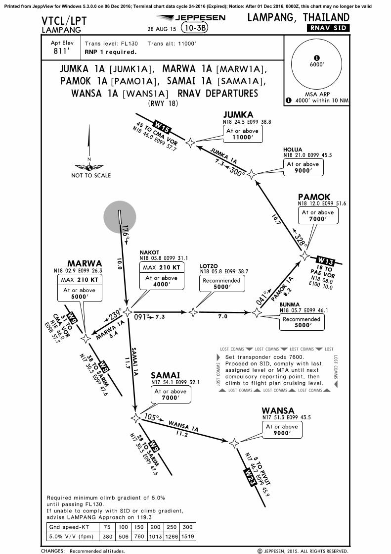
VTCL/LPT JEPPESEN LAMPANG, THAILAND.RNAV.SID.LAMPANG
6000'1
10-3B
Trans level: FL130 Trans alt: 11000'
(RWY 18)
CHANGES:
75 100 150 200 250 300
5.0% V/V (fpm) 380 506 760 1013 1266 1519
Gnd speed-KT
MSA ARP
28 AUG 15
RNP 1 required.
1 4000' within 10 NM
Required minimum climb gradient of 5.0% until passing FL130.If unable to comply with SID or climb gradient,advise LAMPANG Approach on 119.3
| JEPPESEN, 2015. ALL RIGHTS RESERVED.
[MARW1A],MARWA 1A[JUMK1A],JUMKA 1APAMOK 1A [PAMO1A], SAMAI 1A [SAMA1A],
WANSA 1A [WANS1A] RNAV DEPARTURES
176^
091^239^
10.0
5.4
7.3 7.0
MARWA 1
A
MAX 210 KT
At or above4000'
N18 05.7 E099 46.1
041^ 8.
2
PAMOK 1
AMAX 210 KT
At or above5000'
SA
MA
I 1A
WANSA 1A
11.7
At or above7000'
N17 54.1 E099 32.1
N17 51.3 E099 43.5
11.2
105^
.W 2 3.
N17 46.7 E099 45.9
5 TO
PIV
UT
At or above7000'
N18 12.0 E099 51.6
328^
10.7
At or above9000'300^
7.3
JUMKA 1A
At or above11000'
N18 24.5 E099 38.8.W 15.45 TO CMA VOR
N18 46.0 E099 57.7
.W 1 3.PAE VORN18 08.0E100 10.0
18 TO
Set transponder code 7600.Proceed on SID, comply with lastassigned level or MFA until nextcompulsory reporting point, thenclimb to flight plan cruising level.
At or above9000'
W 9
28 TO
SARIM
N17 30.5 E099 47.6
W 9
38 TO
SARIM
N17 30.5 E099 47.6
W 9 N18 46.0
E098 57.751 TO
CM
A V
OR
5000'Recommended
Recommended5000'
Recommended altitudes.
NOT TO SCALE
Printed from JeppView for Windows 5.3.0.0 on 06 Dec 2016; Terminal chart data cycle 24-2016 (Expired); Notice: After 01 Dec 2016, 0000Z, this chart may no longer be valid

COMMSLOST COMMSLOST COMMSLOST LOST
COMMSLOST COMMSLOST COMMSLOST
COMMS
LOST
COMMS
LOST
SOKOM
TOHANN18 32.9 E099 22.7 BARTO
N18 30.6 E099 42.8
SONPAN18 22.0 E099 43.5
HOKONN18 14.0 E099 42.4
PAHIN
MARBON18 00.4 E099 38.7
.W 15.
N18 12.5E099 49.5
.W 1 3.
196^
14.0
.W 2 3.
CMA VORN18 46.0
E098 57.7
MA
RBO
1A
PAE VORN18 08.0E100 10.0
N17 46.7 E099 45.9
N18 29.6 E099 29.1
27 TO At or above7000'
At or above11000'
MAX 250 KT
At or aboveFL130
At or aboveFL130
20 TO
15 T
O P
IVUT
Apt Elev
811'
VTCL/LPT JEPPESEN LAMPANG, THAILAND.RNAV.SID.LAMPANG
6000'1
10-3C
Trans level: FL130 Trans alt: 11000'
(RWY 36)
CHANGES:
75 100 150 200 250 300
5.0% V/V (fpm) 380 506 760 1013 1266 1519
Gnd speed-KT
MSA ARPRNAV DEPARTURES
28 AUG 15
| JEPPESEN, 2012, 2015. ALL RIGHTS RESERVED.
[PAHI1A],PAHIN 1A[MARB1A],MARBO 1APHATA 1A [PHAT1A], TOHAN 1A [TOHA1A]
RNP 1 required.
1 4000' within 10 NM
Required minimum climb gradient of 5.0% until passing FL130.If unable to comply with SID or climb gradient,advise LAMPANG Approach on 119.3
300^
086^
356^
7.0
TOHAN 1A
MAX 250 KT
At or above5000'
13.0
176^
188^
120^
103^
12.9
8.6
7.0
6.9
8.1
At or above9000'
MAX 250 KT
PHATA 1A
PAHIN 1A
.W 15.PAE VORN18 08.0
E100 10.0
22 TO
PHATAN18 18.6E099 49.9
At or above11000'
MAX 250 KTAt or above
FL130
Set transponder code 7600.Proceed on SID, comply with lastassigned level or MFA until nextcompulsory reporting point, thenclimb to flight plan cruising level.
None.
NOT TO SCALE
Printed from JeppView for Windows 5.3.0.0 on 06 Dec 2016; Terminal chart data cycle 24-2016 (Expired); Notice: After 01 Dec 2016, 0000Z, this chart may no longer be valid

36
6479' 1975m
197' 60mStopway
NDB
VOR
Elev 811'
18
Elev 789'
LAMPANG, THAILANDLAMPANGN18 16.3 E099 30.3
11-1Apt ElevVTCL/LPT
811'
*LAMPANG Tower 122.3
RWY
ADDITIONAL RUNWAY INFORMATION
ThresholdLANDING BEYOND
USABLE LENGTHS
WIDTHTAKE-OFFGlide Slope18
3698'30m
RL
RCLM (DAY only) RCLM (DAY only)or RLor RL
18-16 18-16
99-30
99-30
99-31
99-31
175^
355^
A
B
Control Tower
Terminal
ARP
VAR 0^
MET
5822'1775m
6150'1875m 5822' 1775m
6150' 1875m
RVR
RVR
RVR
None. | JEPPESEN, INC., 2002, 2013. ALL RIGHTS RESERVED.
JEPPESEN
PAPI-L (angle 3.0^)
17 JUL 15
500 2000 2500
800600200
Feet
Meters
0
0 1000
30001000 1500
400
CHANGES:
TAKE-OFF
All Rwys
ABCD
400m
LVP must be in Force
AIR CARRIER (JAA)
All Rwys
250m
300m
Printed from JeppView for Windows 5.3.0.0 on 06 Dec 2016; Terminal chart data cycle 24-2016 (Expired); Notice: After 01 Dec 2016, 0000Z, this chart may no longer be valid

103^163^
[ML26]
[FL36]
[FL36][ML26]
2000
2000
2000
2000
2000
2000
2000
2000
2000
2000
3000
3000
3000
(IF)
LPN
ILPN
LPN
ILPN
D5.9
D5.6
D2.6
D2.3LOC DME
356^ 109.7 ILPNI L P N
VTCL/LPT11-1
LAMPANG, THAILANDLAMPANG
*LAMPANG Approach (R) *LAMPANG Tower
119.3 122.3LOCILPN
109.7 356^ 2400'(1589')
MDA(H)
1350'(539')
Apt Elev 811'
811'
MSA LPN VOR4000'
6000'MISSED APCH:
Trans alt: 11000'Trans level: By ATCAlt Set: hPa Rwy Elev: 29 hPa
Gnd speed-Kts 70 90 100 120 140 1602500'
356^PAPI-L
BRIE
FIN
G S
TRIP
TM
on
811'Rwy 36
Rwy 36
PIWAN
LPNILPND2.6
D2.3
1.5 3.3 4.4
3300'
2400'356^
JEPPESEN
LOC Rwy 36
D5.9 ILPND5.6 LPN
Climb STRAIGHT AHEAD to 2500', then LEFT turn andcontinue climb on heading 126^ to LPN VOR, then RIGHT turn to
hold or as directed by ATC.intercept LPN VOR R-154 and continue climb to MARBO at 6000' and
within 10 NM
LPNILPND5.9
D5.6 D10.3 ILPND10.0 LPN
2100'MDA
CIRCLE-TO-LAND
A
B
C
D
MaxKts MDA(H)
STRAIGHT-IN LANDING RWY 36
1500'
MDA(H)
1350'
1500'
(539')
(539')
(689')
(689')
2800m-
3200m-
3600m-
176^356^
No Circling
1350'
LAMPANG114.7 LPN
LPN
D
05
510
1520
334^154^
329^5.0
3.6
2.6
4.65.0
038^
038^
311^
311^
.W.13..W.9.
MARBO
KOKIT
TONUN
LPTS1
PIWAN
PABEK
126^hdg
154^
356^
10 DME LP
N VO
R
6000
D10.3 ILPN
R-184/D12.1 LPN
R-192/D15.2 LPN
R-182 D19.1 LPN
3300
18-00
18-10
18-20
99-20 99-30 99-40 99-50
356^
4900
4000
3600
.W23.
2800m
D12.0 LPN
LPTS2R-162/D13.6 LPN
18
36
17 JUL 15
2963'
3058'
2291'
3574'
2074'
2251' 3022'
3714'
3770'
2329'
1657'1919'
1273'
2917'
4157'
Descent Angle
1467'
MAX 230 KT
Speed restricted to MAX 230 KT until after turn.
1. VOR, DME required.
R-176/D10.0 LPN
MAX 230 KT
FinalApch Crs
| JEPPESEN, 2004, 2015. ALL RIGHTS RESERVED.
Procedure Alt
MAP at D2.6 ILPN/D2.3 LPN
3.00^ 372 478 531 637 743 849
3.00^TCH 50'
Minimums, descent angle.
(IAF)
6000
CHANGES:
ILPN DME
ALTITUDE
MAP 3.0 4.01465' 1785'
5.02105'
FAF2400'1350'
135
180
205
100
(IAF)
6000
6000
(IAF)
PA
NS O
PS
R-154/D18.1 LPN
Printed from JeppView for Windows 5.3.0.0 on 06 Dec 2016; Terminal chart data cycle 24-2016 (Expired); Notice: After 01 Dec 2016, 0000Z, this chart may no longer be valid
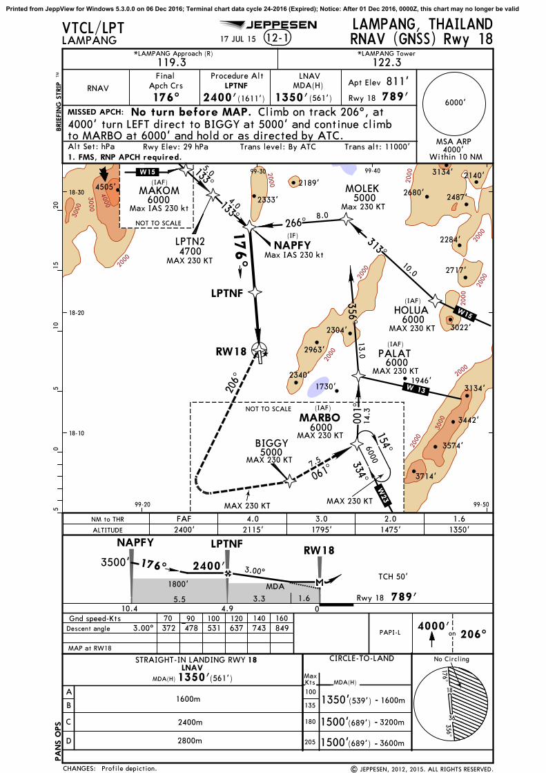
2000
2000
2000
2 00 0
2000
2000
2000
2000
2000
3000
3000
3000
2000
4000
789'
Gnd speed-Kts
5.5
2400'176^3500'
3.3 Rwy 18
100 120 140 160
A
B
C
D
STRAIGHT-IN LANDING RWY 18
MDA(H)1350'(561')
4000'
6000'
RW18
LAMPANG, THAILANDLAMPANG 12-1
*LAMPANG Approach (R) *LAMPANG Tower
119.3 122.3
RNAV
FinalApch Crs
176^ 2400'(1611')
MDA(H)
1350'(561')
Apt Elev
789'MISSED APCH:
206^
811'Rwy 18
Trans alt: 11000'Trans level: By ATCAlt Set: hPa Rwy Elev: 29 hPa
VTCL/LPT
BRIE
FIN
G S
TRIP
TM
on
JEPPESEN
Within 10 NM
MAKOM(IAF)
6000
5.0
LPTN2 NAPFY
PALATRW18
133^
133^NOT TO SCALE
4700
4.0
3022'
1730'
2284'
3442'
2304'
2717'
1946'
2140'
2487'
3574'
2963'
3134'
2189'4505'
3134'
2340'
2333'2680'
MARBO
334^
154^
(IAF)
(IAF)
001^
1 4. 3
6000
6000
BIGGY
206^
.W.13.
NOT TO SCALE
(IF)
NAPFY
Descent angle 372 478 531 637 743 849
1800' MDA
1600m
2400m
2800m
CIRCLE-TO-LAND
MaxKts MDA(H)
1500'
1350'
1500'
(539')
(689')
(689')
1600m-
3200m-
3600m-
176^356^
No Circling
.W15..W23.
5000
6000
RNAV (GNSS) Rwy 18
1. FMS, RNP APCH required.
Procedure Alt LNAV
MSA ARP
LPTNF
No turn before MAP. Climb on track 206^, at4000' turn LEFT direct to BIGGY at 5000' and continue climbto MARBO at 6000' and hold or as directed by ATC.
Max IAS 230 kt
Max IAS 230 kt
MOLEK5000
266^8.0
LPTNF
HOLUA6000
(IAF)
313^10.0
356^13.0
176^
.W15.
061^
18-10
18-20
18-30
99-20
99-30 99-40
99-50
LPTNF
10.4 4.9 01.6
LNAV
7.5
3714'
05
510
1520
70 90
PAPI-L
PA
NS O
PS
18
36
4000'
MAP at RW18
17 JUL 15
MAX 230 KT
MAX 230 KT
MAX 230 KT
MAX 230 KT
MAX 230 KT
MAX 230 KT
MAX 230 KT
Max 230 KT
| JEPPESEN, 2012, 2015. ALL RIGHTS RESERVED.
3.00^
3.00^
TCH 50'
Profile depiction.
ALTITUDE 2400'FAF 4.0 3.0 2.0 1.6
1795'2115' 1475' 1350'NM to THR
CHANGES:
135
180
205
100
Printed from JeppView for Windows 5.3.0.0 on 06 Dec 2016; Terminal chart data cycle 24-2016 (Expired); Notice: After 01 Dec 2016, 0000Z, this chart may no longer be valid

2000
2000
2000
3000
3000
2000
2000
2000
VTCL/LPT12-2
LAMPANG, THAILANDLAMPANG
*LAMPANG Approach (R) *LAMPANG Tower
119.3 122.3
RNAV356^ 2400'(1589')
MDA(H)
1350'(539')
Apt Elev 811'
811'
4000'
6000'MISSED APCH:
Trans alt: 11000'Trans level: By ATCAlt Set: hPa Rwy Elev: 29 hPa
Gnd speed-Kts 70 90 100 120 140 160 2500'356^PAPI-L
BRIE
FIN
G S
TRIP
TM
Rwy 36
JEPPESEN
RNAV (GNSS) Rwy 36
Procedure AltLPTSF
LNAV
MSA ARP
Climb on track 356^, at 2500' turn RIGHT direct to MAMOR
directed by ATC.
1. FMS, RNP APCH required.
PIWAN
2400' 356^
2100'
Descent Angle 372 478 531 637 743 849
MDA
3300'
CIRCLE-TO-LAND
A
B
C
D
MaxKts MDA(H)
STRAIGHT-IN LANDING RWY 36
LNAV
1500'
MDA(H)
1500'
(539')
(689') 3200m-
3600m-
176^356^
No CirclingNo Circling
1600m
2400m
135
180
205
1001350'(539') 1600m-
1350'
05
510
1520
(IF)
RW36
334^154^
329^5.0
3.6
2.6
4.65.0
038^
038^
311^
311^
.W.9.
MARBOKOKIT
TONUN
LPTS1
PIWAN
LPTS2
PAHIN
356^
6000
Max IAS 230 kt
3022'
3714'
3770'
2329'
1730'
1917'
1871'
2884'
1346' 3442'
1680'
2304'
1946'
3574'
2996'
2963'
3764'
3134'
2307'
2074'
1260'
2340'
1273'
2917'
4157'
356^
4000
36004900
(IAF)
MAMOR
within 10 NM
221^
15.8
LPTSF
on
(689')2800m
at 3200' and continue climb to MARBO at 6000' and hold, or as
18-00
18-10
18-20
99-20 99-30 99-40 99-50
.W23.
1 6. 0
179^
18
36
2291'
MAP at RW36
17 JUL 15
MAX 190 KT
MAX 190 KT
MAX 210 KTMAX 230 KT
MAX 210 KTMAX 190 KT
MAX 230 KT
MAX 230 KT
FinalApch Crs
| JEPPESEN, 2012, 2015. ALL RIGHTS RESERVED.
TCH 50'3.00^
3.00^
Profile depiction.
ALTITUDE 1350'1.5 2.0 3.0 4.0 FAF
1815'1500' 2135' 2400'DIST to THR
CHANGES:
1.5 4.4
RW36LPTSF
4.8 9.20Rwy 36 811' 3.3
(IAF)
6000
(IAF)
6000
6000
3200
PA
NS O
PS
.W13.
Printed from JeppView for Windows 5.3.0.0 on 06 Dec 2016; Terminal chart data cycle 24-2016 (Expired); Notice: After 01 Dec 2016, 0000Z, this chart may no longer be valid

345^
010^
103^
154^
[FF18] [MA18]
[FF18]
[MA18]
2000
2000
2000
2000
2000
2000
2000
2000
2000
2000
3000
3000
3000
3000
2000
4000
789'
D5.0
5.0
2400'178^3500'
3.3 Rwy 18
A
B
C
D
STRAIGHT-IN LANDING RWY 18
MDA(H)1350'(561')
4000'
6000'
D1.7
1.6
LAMPANG, THAILANDLAMPANG 13-1
*LAMPANG Approach (R) *LAMPANG Tower
119.3 122.3VOR
114.7LPN
FinalApch Crs
178^D5.0
2400'(1611')
MDA(H)
1350'(561')
Apt Elev
789'MISSED APCH:
LPN
114.7
811'Rwy 18
Trans alt: 11000'MSA LPN VOR
LAMPANG
114.7 LPNLPN
D
Trans level: By ATCAlt Set: hPa Rwy Elev: 29 hPa
VTCL/LPT
BRIE
FIN
G S
TRIP
TM
JEPPESEN
VOR Rwy 18
1. DME required. Within 10NM
MAKOM(IAF)
6000
5.0
R-336/D18.1 LPN
LPTN1
VORZY
PABEK
D5.0
D1.7
133^133^
NOT TO SCALE
4700
4.6
D13.6
D10.0
178^
3022'
3714'
1730'
1917'
2884'
2284'
3442'
2304'
2717'
1946'
2140'
2487'
3574'
2996'
2963'
3134'
2189'4505'
3134'
2340'
2333'2680'
NADON
MARBO
334^
154^
(IAF)
(IAF)
334^6.1
18.1
DME
Arc
10 DM
E Arc
6000
6000
6000
MATAN
POODA
D12.0
D12.0
R-154/D18.1 LPNR-208/D16.1 LPN
209^
209^
R-180/D18.1 LPN
1
1
2
2
3500
NOT TO SCALE
(IF)
18-10
18-20
18-30
99-40 99-50
VORZYD10.0 LPN
VOR
Descent angle 372 478 531 637 743 849
1800'MDA
3000m
MAP at D1.7
CIRCLE-TO-LAND
MaxKts MDA(H)
1500'
1350'
1500'
(539')
(689')
(689')
3000m-
3200m-
3600m-
176^356^
18
No Circling
.W15.
.W23.
99-30
| JEPPESEN, 2000, 2015. ALL RIGHTS RESERVED.
4000
5000
6000
05
510
1520
Gnd speed-Kts 70 90 100 120 140 160
PA
NS O
PS
PAPI-L
36
Climb straight ahead to LPN VOR then turn RIGHT to interceptLPN VOR R-209 and continue climb to POODA at 4000'. Then turn LEFT to intercept LPN VOR 18.1 DME ARC and climb to MATAN at 5000'. Then continue climb to MARBO at 6000' and hold, or as directed by ATC.
RT114.7
LPN
R-209^
17 JUL 15
MAX 230 KT
MAX230 KT
Procedure Alt
3.00^ TCH 50'
3.00^
Minimums, profile depiction.
.W.13.
LPN DME
ALTITUDE 2400'FAF 4.0 3.0 2.0 MAP
1760'2080' 1445' 1350'
CHANGES:
135
180
205
100
Printed from JeppView for Windows 5.3.0.0 on 06 Dec 2016; Terminal chart data cycle 24-2016 (Expired); Notice: After 01 Dec 2016, 0000Z, this chart may no longer be valid

103^162^
2000
2000
(IF)
D5.6
D2.3
VTCL/LPT13-2
LAMPANG, THAILANDLAMPANG
*LAMPANG Approach (R) *LAMPANG Tower
119.3 122.3VORLPN
114.7 355^ 2400'(1589')
MDA(H)
1350'(539')
Apt Elev 811'
811'
MSA LPN VOR4000'
6000'MISSED APCH:
Trans alt: 11000'Trans level: By ATCAlt Set: hPa Rwy Elev: 29 hPa
Gnd speed-Kts 70 90 100 120 140 1602500'
355^PAPI-L
BRIE
FIN
G S
TRIP
TM
on
811'Rwy 36
Rwy 36
VORZO
D2.3
1.5 3.3 4.4
3300'
2400'355^
JEPPESEN
VOR Rwy 36
Climb STRAIGHT AHEAD to 2500', then LEFT turn andcontinue climb on heading 126^ to LPN VOR, then RIGHT turn to
hold or as directed by ATC.intercept LPN VOR R-154 and continue climb to MARBO at 6000' and
within 10 NM
D5.6
2100'MDA
CIRCLE-TO-LAND
A
B
C
D
MaxKts MDA(H)
STRAIGHT-IN LANDING RWY 36
1500'
MDA(H)
1350'
1500'
(539')
(539')
(689')
(689')
2800m-
3200m-
3600m-
176^356^
18
No Circling
1350'
334^154^
329^5.0
3.6
2.6
4.45.0
040^
040^
312^
312^MARBO
KOKIT
TONUN
LPTS3
VORZO
LPTS4
PABEK
126^hdg
154^
355^
6000
3300
18-00
18-10
18-20
99-20 99-30 99-40 99-50
3022'
3714'
3770'
2329'
1730'
1917'
1871'
2884'
1346' 3442'
1680'
2304'
1946'
3574'
2996'
2963'
3764'
3134'
2307'
2074'
1260'
2340'
1273'
2917'
4157'
355^
D5.6
1. DME required.
D10.010
DME
Arc
D12.0
R-192/D15.2
R-182/D19.1
4000
4900R-162/D13.6
.W23.
R-184/D12.13600
D10.0
MAP at D2.3
Descent angle 372 478 531 637 743 849
2800m
(IAF)
05
510
1520
36
| JEPPESEN, 2004, 2015. ALL RIGHTS RESERVED.
2291'
LPN
LAMPANG114.7 LPN
D
VOR
17 JUL 15
MAX 230 KT
MAX 230 KT
Speed restricted to MAX 230 KT until after turn.
FinalApch Crs
Procedure Alt
3.00^
3.00^
Minimums, profile depiction.
TCH 50'
.W.13..W.9.
(IAF)
6000
CHANGES:
LPN DME
ALTITUDE
MAP 3.0 4.01560' 1880'
5.02190'
FAF2400'1350'
135
180
205
100
(IAF)
6000
6000
R154/D18.1
PA
NS O
PS
Printed from JeppView for Windows 5.3.0.0 on 06 Dec 2016; Terminal chart data cycle 24-2016 (Expired); Notice: After 01 Dec 2016, 0000Z, this chart may no longer be valid

General Information
Location: NAN THAICAO/IATA: VTCN / NNTLat/Long: N18° 48.5', E100° 47.0'Elevation: 685 ft
Airport Use: PublicDaylight Savings: Not ObservedUTC Conversion: -7:00 = UTCMagnetic Variation: 0.9° W
Customs: YesAirport Type: IFRLanding Fee: YesControl Tower: YesJet Start Unit: NoLLWS Alert: NoBeacon: Yes
Sunrise: 2337 ZSunset: 1039 Z
Runway Information
Runway: 02Length x Width: 6562 ft x 148 ftSurface Type: asphaltTDZ-Elev: 681 ftLighting: Edge
Runway: 20Length x Width: 6562 ft x 148 ftSurface Type: asphaltTDZ-Elev: 685 ftLighting: Edge
Communication Information
ATIS: 35.500Nan Tower: 118.550Nan Approach Approach: 120.250
Airport Information For VTCN
Printed on 06 Dec 2016
Page 1
(c) JEPPESEN SANDERSON, INC., 2016, ALL RIGHTS RESERVED
jep=JEPPESEN
JeppView for Windows

Apt ElevNAN, THAILAND
11-1685'
D
C
B
AElev 679'
Elev 682'
118.55
200^
020^
N18 48.5 E100 47.0
ControlTower
*NAN Tower
LVP must be in ForceRCLM (DAY only)
or RLRCLM (DAY only)
or RL
ATIS
355
VTCN/NNT
18-48 18-48
18-49 18-49
100-46
100-46
100-47
100-47
100-48
100-48
RVR
VAR 0^
Terminal
Ground Service
ARP
10 APR 15
JEPPESEN
NAN NAKHON
Airport name. | JEPPESEN, 1998, 2015. ALL RIGHTS RESERVED.
6562
' 200
0m
RWY
ADDITIONAL RUNWAY INFORMATION
ThresholdLANDING BEYOND
USABLE LENGTHS
WIDTHTAKE-OFFGlide Slope02
20RL 148'
45m
TAKE-OFF
ABCD
All Rwys
400m
VOR
20
02
0
0 200 400 600 800 1000
1000 2000 3000 4000
1200
Feet
Meters
CHANGES:
NDB
AIR CARRIER (JAA)
250m
300m
5581'1701mPAPI-L (angle 3.4^)PAPI-L (angle 3.0^)RL
Printed from JeppView for Windows 5.3.0.0 on 06 Dec 2016; Terminal chart data cycle 24-2016 (Expired); Notice: After 01 Dec 2016, 0000Z, this chart may no longer be valid

323^
268^
221^
NAN
115.7
NAN115.7 NANNAN
D
NAN
355 NNNN
SAREE(IAF)
143^
088^
.W.29.
.W.12.
.W.25.041^
D2.7INAN
INAND6.0
INAND13.0
143^
13 DME A rc INAN4500
069^
45009.5
85.0
34.0
D20.0 NAN
7500
7500
7000
200^
4500
020^
(IF)
CHIANG RAI VOR
CHIA
NG
MA
I VO
R
PHRAE VOR
05
510
1520
18-30
18-40
100-40 100-50
1549'
3891'
3652'
3871'
4493'
2864'
4288'
VTCN/NNT11-1
NAN, THAILANDILS DME or LOC DME Rwy 02
ATIS *NAN Approach *NAN Tower
355 120.25 118.55LOC
INAN
110.3
020^ 110.3 INANI N A N
FinalApch Crs
020^
GSD6.0 INAN
2500'(1821')
ILSDA(H)
990'(311')
Apt Elev 685'
679'Climb on track 020^ until D5.0 INAN, then turn
MSA NAN VOR
7500'
270^090^
180^
360^
6700' 7800'
8500'
D5.0INAN
Rwy 02
205
180
135
100KtsMax
A
B
C
D
(965')
MDA(H)
CIRCLE-TO-LANDSTRAIGHT-IN LANDING RWY
(621')MDA(H)
2120'
2460'
(1435')
(1775')
Gnd speed-Kts 70 90 100 120 140 160
ALTITUDE
RWY 02 679'
02
TCH 58'
GS 2500'2500'
020^4500'
on 020^ INANMAP at D2.7 INAN/D2.1 NAN
LOC Descent Gradient
ILS LOC (GS out)
990'(311')DA(H)
ILS GS
MISSED APCH:
BRIE
FIN
G S
TRIP
TM
426 548 609 731 853 9745.9% 418 538 597 717 836 956
FAF to MAP 3.3 2:50 2:12 1:59 1:39 1:25 1:14
D5.0
1300'
1650'
PAPI-L
020^
020^
1300m3000m
3200m
-3000m
-4800m
-4800m
RIGHT continuing climb to 4500' and back to D6.0 INAN at4500' and hold.
D5.4 NAN
D2.1NAN
D5.4 NAN
ILS DME
D12.4 NAN
3.40^
D12.4 NANINAND13.0
D5.4 NANINAND6.0
D2.1D2.7INAN
NAN
2375'
104
10 APR 15NAN NAKHON
JEPPESEN
| JEPPESEN, 2004, 2015. ALL RIGHTS RESERVED.Airport name.
PA
NS O
PS
1962'
1765'
1283'
1621'
2375'
3652'
3071'
Trans alt: 11000'Trans level: By ATCAlt Set: hPa Rwy Elev: 25 hPa
7.0 3.3 1.6
CHANGES:
2316'
2930'
INAN DME 3.04.0LOC
(GS out) 1400'1760'2125'5.0
Printed from JeppView for Windows 5.3.0.0 on 06 Dec 2016; Terminal chart data cycle 24-2016 (Expired); Notice: After 01 Dec 2016, 0000Z, this chart may no longer be valid
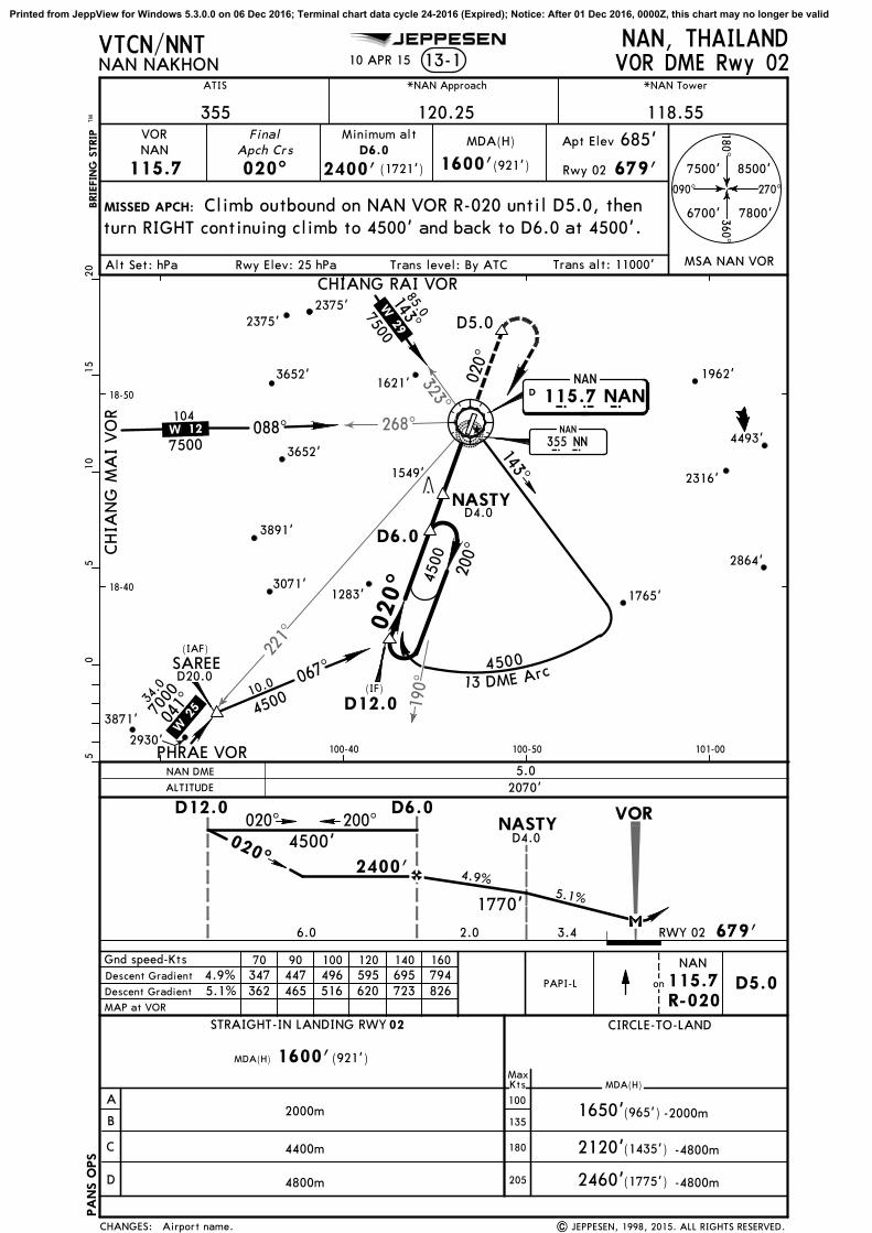
221^
268^323^
190^
NAN
115.7 NANN A N
D020^
D12.0
D6.0
143^
143^
088^
067^
MISSED APCH:
*NAN Approach *NAN Tower
120.25VOR Final
Apch Crs
020^
13-1NAN, THAILANDVOR DME Rwy 02
7500'
1650'
MAP at VOR
1600'
Minimum altD6.0
2400'NAN
115.7
6700' 7800'
8500'
MSA NAN VOR
05
510
1520
(IF)
7000
450013 DME Arc
CHIA
NG
MA
I VO
R
CHIANG RAI VOR
7500
Gnd speed-Kts 70 90 100 120 140 160
2000m
4800m
MDA(H) 1600'
2120'(1435')
2460'(1775')
10.0
85.07500
(IAF)
6.0 2.0
PHRAE VOR
041^34
.0
100-40 100-50 101-00
18-40
18-50
200^
SAREED20.0
200^020^
Descent Gradient 5.1%
4500
4500
100
135
180
205
MDA(H)
(921')
118.55
(921')
NASTY
D5.0
D5.0
4.9%5.1%
4400m
362 465 516 620 723 826
1549'
3891'
3652'
3871'
BRIE
FIN
G S
TRIP
TM
115.7R-020
NAN
on
Apt Elev
679'
NASTYD4.0
3.4
D4.0
Descent Gradient 4.9% 347 447 496 595 695 794
Climb outbound on NAN VOR R-020 until D5.0, thenturn RIGHT continuing climb to 4500' and back to D6.0 at 4500'.
020^
VTCN/NNT
ATIS
355
(965')
.W.12.
.W.29.
.W.25.
2375'
(1721') Rwy 02
685'
PAPI-L
RWY 02
270^090^
180^
360^
4493'
2864'
2375'
104
10 APR 15NAN NAKHON
JEPPESEN
Airport name. | JEPPESEN, 1998, 2015. ALL RIGHTS RESERVED.
PA
NS O
PS
NAN
N N
CHANGES:
MaxKts MDA(H)
CIRCLE-TO-LAND
D
C
B
A
VOR
020^
679'
D12.0
2400'
D6.0
STRAIGHT-IN LANDING RWY 02
4500'
355 NN
1770'
1962'
1765'
1621'
3071'
Trans alt: 11000'Alt Set: hPa Rwy Elev: 25 hPa Trans level: By ATC
3652'
-2000m
-4800m
-4800m
2316'
1283'
2930'
ALTITUDE
5.0NAN DME
2070'
Printed from JeppView for Windows 5.3.0.0 on 06 Dec 2016; Terminal chart data cycle 24-2016 (Expired); Notice: After 01 Dec 2016, 0000Z, this chart may no longer be valid

221^
268^
323^
033^
NAN
115.7 NANN A N
D
D6.0
088^
041^
D11.0
203^
041^
12 DM
E Arc
023^
7500
7500
MISSED APCH:
*NAN Approach *NAN Tower
120.25VOR Final
Apch Crs
203^Apt Elev
13-2NAN, THAILANDVOR DME Rwy 20
7500'
1840'(1155')
05
510
1650'
Minimum altD6.0
2800'NAN
115.7270^090^
180^
360^
6700' 7800'
8500'
MSA NAN VOR
(965')
4300'LT
D6.0 D11.0
2800'
5.5
203^
Gnd Speed-Kts 70 90 100 120 140 160Descent Gradient 6.1%
MDA(H) 1650'(965')
2000m
4800m2015'(1330')
CHIA
NG
MA
I VO
R
CHIANG RAI VOR54
.0
Climb STRAIGHT AHEAD to 4300' then turn LEFT
7500
143^
85.0
(IF)
2420'5.0
2050'4.0
1680'3.0
D11.0
5.0
MAP at VOR
20
4300
MDA(H)685'
118.55
988
6.1%
2375'
2185'
BRIE
FIN
G S
TRIP
TM
089^
PHRAE VOR
031^
211^
6000
APT.
023^ 203^4300'
4000m
1840'(1155')100
135
180
205
1549'
back to D6.0 at 4300' or as directed.
D6.0
VTCN/NNT
ATIS
355
.W.29.
.W.12.
.W.25.
3652'
(2115')
432 556 618 741 865
-2000m
-2400m
-4800m
18-50
19-00
100-40 100-50 101-00
PAPI-L
104
10 APR 15
JEPPESEN
NAN NAKHON
Airport name. | JEPPESEN, 1998, 2015. ALL RIGHTS RESERVED.
PA
NS O
PS
NAN
N N
CHANGES:
MaxKts MDA(H)
CIRCLE-TO-LAND
D
C
B
A
685'
ALTITUDE
NAN DME
STRAIGHT-IN LANDING RWY
355 NN
1962'1621'
3652'
Trans alt: 11000'Alt Set: hPa Apt Elev: 25 hPa Trans level: By ATC
2375'
VOR
Printed from JeppView for Windows 5.3.0.0 on 06 Dec 2016; Terminal chart data cycle 24-2016 (Expired); Notice: After 01 Dec 2016, 0000Z, this chart may no longer be valid

MISSED APCH:
NDBNN
355
FinalApch Crs
026^
Apt Elev
NAN, THAILAND
MSA NN NDB
MAP at NDB
685'No FAF
05
510
N N
NAN
JEPPESEN
NDB Rwy 02CAT A & B
270^090^
180
^360
^
7600' 8600'
7900'6800'
10 APR 15
Rwy 02 679'
*NAN Approach *NAN TowerATIS
355 120.25 118.55
Alt Set: hPa Rwy Elev: 25 hPa Trans alt: 11000'
No turn before MAP. Climb on 026^ bearing until
as directed by ATC.
206^
026^
026^
197^
6200 Max IAS 230 Kts
PAPI 026^3600'
4 Min
MDA(H)
1800'(1121')
Rwy 02
3000'
(IAF)
02
MDA(H) 1800'(1121')
2000m
2400m
1800' (1115')
1800' (1115')
-2000m
-2400m
18-40
18-50
100-40 100-50
2537'
2012' 2376'
3891'
2316'
3652'
1765'
1283'
3071'
1542'
3811'
1309'
1549'3116'
2375'
026^
6200'
VTCN/NNT
3600' then turn RIGHT direct to NN NDB at 6200' and hold or
355 NN
Trans level: By FL130
PA
NS O
PS
16-1
BRIE
FIN
G S
TRIP
TM
NAN NAKHON
Airport name. | JEPPESEN, 2014, 2015. ALL RIGHTS RESERVED.
D
N A N
115.7 NANNAN
CHANGES:
135
MaxKts MDA(H)
CIRCLE-TO-LAND
B
A
679'
197^
026^
NDB
STRAIGHT-IN LANDING RWY
100
Printed from JeppView for Windows 5.3.0.0 on 06 Dec 2016; Terminal chart data cycle 24-2016 (Expired); Notice: After 01 Dec 2016, 0000Z, this chart may no longer be valid

MISSED APCH:
NDBNN
355
FinalApch Crs
026^
Apt Elev
NAN, THAILAND
MSA NN NDB
MAP at NDB
685'No FAF
05
510
N N
NAN
JEPPESEN
NDB Rwy 02
270^090^
180
^360
^
7600' 8600'
7900'6800'
10 APR 15
Rwy 02 679'
*NAN Approach *NAN TowerATIS
355 120.25 118.55
Alt Set: hPa Rwy Elev: 25 hPa Trans alt: 11000'
No turn before MAP. Climb on 026^ bearing until
as directed by ATC.
206^
026^
026^
6200
Max IAS 230 Kts
PAPI 026^3500'
3 Min
MDA(H)
2800'(2121')
Rwy 02
3500'
(IAF)
02
MDA(H) 2800'(2121')
4800m 2800'(2115') -4800m
18-40
18-50
100-40 100-50
2537'
2012' 2376'
3891'
2316'
3652'
1765'
1283'
3071'
1542'
3811'
1309'
1549'3116'
2375'
026^
CAT C & D
185
^
6200'
VTCN/NNT
355 NN
3500' then turn RIGHT direct to NN NDB at 6200' and hold or
Trans level: By FL130
PA
NS O
PS
16-2
BRIE
FIN
G S
TRIP
TM
NAN NAKHON
Airport name. | JEPPESEN, 2014, 2015. ALL RIGHTS RESERVED.
D
N A N
115.7 NANNAN
CHANGES:
205
MaxKts MDA(H)
CIRCLE-TO-LAND
D
C
679'
185^
026^
NDB
STRAIGHT-IN LANDING RWY
180
Printed from JeppView for Windows 5.3.0.0 on 06 Dec 2016; Terminal chart data cycle 24-2016 (Expired); Notice: After 01 Dec 2016, 0000Z, this chart may no longer be valid

General Information
Location: PHRAE THAICAO/IATA: VTCP / PRHLat/Long: N18° 07.9', E100° 09.9'Elevation: 538 ft
Airport Use: PublicDaylight Savings: Not ObservedUTC Conversion: -7:00 = UTCMagnetic Variation: 0.8° W
Customs: NoAirport Type: IFRLanding Fee: YesControl Tower: YesJet Start Unit: NoLLWS Alert: NoBeacon: Yes
Sunrise: 2338 ZSunset: 1043 Z
Runway Information
Runway: 01Length x Width: 4921 ft x 98 ftSurface Type: asphaltTDZ-Elev: 538 ftLighting: EdgeStopway: 246 ft
Runway: 19Length x Width: 4921 ft x 98 ftSurface Type: asphaltTDZ-Elev: 537 ftLighting: EdgeStopway: 246 ft
Communication Information
ATIS: 34.000Phrae Tower: 118.600Phrae Approach Approach: 120.100
Airport Information For VTCP
Printed on 06 Dec 2016
Page 1
(c) JEPPESEN SANDERSON, INC., 2016, ALL RIGHTS RESERVED
jep=JEPPESEN
JeppView for Windows

Elev 538'
Elev 535'
4921
'1500m
Stopway246' 75m
Stopway246' 75m
NDB
ADDITIONAL RUNWAY INFORMATIONUSABLE LENGTHS
LANDING BEYONDThreshold Glide Slope TAKE-OFF WIDTH
30m98'
1901
RWY
Apt ElevPHRAE, THAILAND
PHRAEN18 07.9 E100 09.910-9538'
*PHRAE Tower
118.6
01005^
VOR
TAKE-OFF
ABCD
250m
300m
400m
RCLM (DAY only)or RL
LVP must be in ForceAll Rwys
AIR CARRIER (JAA)
RCLM (DAY only)or RL
All Rwys
VTCP/PRH
*ATIS
340
RL PAPI (angle 3.2^)
02^W
Terminal
19185^
18-08 18-08
100-10
100-10
ARP
JEPPESEN
| JEPPESEN, 1999, 2014. ALL RIGHTS RESERVED.
RL PAPI (angle 3.5^)
1 AUG 14
Reindexed.CHANGES:
1000
4002000
0Feet
Meters
500 20001500 2500
800600
Printed from JeppView for Windows 5.3.0.0 on 06 Dec 2016; Terminal chart data cycle 24-2016 (Expired); Notice: After 01 Dec 2016, 0000Z, this chart may no longer be valid

1000
1000
1000
2000
3000
3000
30002000
2000
3000
4000
3000
1000
2000
2000
2000
2000
3000
1000
1000
2000
10001000
1000
2000
2000
3000
MISSED APCH:
PHRAE, THAILANDPHRAE 12-1
*PHRAE Approach *PHRAE Tower
120.1 118.6Final
Apch Crs
006^MDA(H)
(362')
Apt Elev
538'Rwy 01
538'
5000'
220^
3 60 ^
6800'
2500'(1962')
Gnd Speed-Kts 70 90 100 120 140 160
MAP at RW~1
PAPI006^
2170'5.0
1850'4.0
1535'3.0
1220'2.0
ALTITUDE
Trans alt: 11000'
VTCP/PRH
Alt Set: hPa Trans level: FL 130
*ATIS
340BRIE
FIN
G S
TRIP
TM
Rwy Elev: 20 hPa
1 AUG 14
New procedure. | JEPPESEN, 2014. ALL RIGHTS RESERVED.
BAMEE
MANOW
WOODU
PREAM
RUBBY
POCKY
MAYOM
PRH~2
PRHSF
PRH~1
RW~1
JEPPESEN
05
510
1520
CIRCLE-TO-LAND
A
B
C
D
MaxKts MDA(H)
STRAIGHT-IN LANDING RWY 01LNAV
MDA(H)
1200'
900'(362')
Climb on track 006^ to 4000' then turn LEFT to POCKY at 6800'and expect further clearance from ATC.
RNAV
No turn before MAP.Speed restricted to MAX IAS 200 Kts until after turn.
LNAV
RNAV (GNSS) Rwy 01
ontrack 4000'
(662')
1200'(662')
PRHSF
900'
NM to RW~1 1.0FAF2500' 900'
MAYOM
006^3.00^
TCH 50'
7000
6800
7000
68005000
1 1
1
1
(IAF)
(IAF) (IAF)
187^
31.9
11.8
245^324^
307^
14.9
7.0
127^
7.0
20.9178
^
006^
036^
(IF)17-50
18-00
18-10
100-00 100-10 100-20
PRH~2
Procedure Alt
036^
-1600m
-2800m
1600m
D
CAT A, B & C
2875'
1021' 2163'
3354'
2035'
2376'
2235'
3173'
3058'
2567'
4033'
4158'
3843' 2077'
2035'
3111'
2071'
2533'
4108'
1208'
3186'
4072'2108'
1939'
1802'
4806'
1821'
2182'
2985'
2123'
3658'
1831'
NOT AUTHORIZED NOT AUTHORIZED
Max IAS200 Kts
2. Descent angle not coincident with PAPI.1. FMS, RNP APCH required.
Descent Angle 3.00^ 372 478 531 637 743 849
MSA ARP
CHANGES:
2.8 538'
5000'
2.2
PRHSF
RW~1
3.86.0 01.0
PRH~1
10.019.04.09.0
2900'
2500'1800'
MDA1200'2400'
2900'
90
120
140
Apt.
Printed from JeppView for Windows 5.3.0.0 on 06 Dec 2016; Terminal chart data cycle 24-2016 (Expired); Notice: After 01 Dec 2016, 0000Z, this chart may no longer be valid
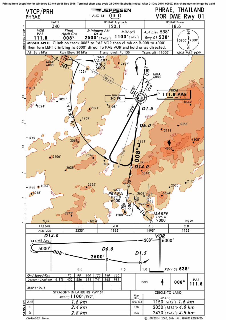
1000
1000
1000
1000
1000
10001000
1000
1000
1000
2000
2000
2000
2000
2000
2000
2000
2000
3000
3000
3000
4000
1000
MISSED APCH:
PHRAE, THAILANDPHRAE 13-1
*PHRAE Approach *PHRAE Tower
120.1 118.6VOR Final
Apch Crs
008^
MDA(H)
1100'(562')
Apt Elev 538'Rwy 01 538'
5800'
MaxKts MDA(H)
CIRCLE-TO-LANDSTRAIGHT-IN LANDING RWY 01
MDA(H) 1100'(562')
C
D
180
(1932')
1.6 km 1150'
2470'
RWY 01
1 80 ^
3 60 ^
7500'
MSA PAE VOR
PHRAE
111.8 PAEPAE
DPHRAE340 PRPR
MAREE
PRAPA
NASRI119^299^
008^ 18
8^
208^
028^
VOR DME Rwy 01
Minimum AltD6.0
2500'(1962')PAE
111.8Climb on track 008^ to PAE VOR then climb on R-008 to 4000'
then turn LEFT climbing to 6000' direct to PAE VOR and hold or as directed.
205
2.4 km2.8 km
A/B 100/135
-4.8 km(1512')2050' -4.8 km(612')-1.6 km
Gnd Speed-Kts 70 90 100 120 140 160
MAP at D1.5
PAPI 008^PAE
111.8
2235'5.0
1865'4.0
1495'3.0
1125'2.0PAE DME
ALTITUDE
008^
D14.0
14 DME Arc
D6.0D1.5
4.5 1.08.0
208^
D16.06000
6000
316^7.0
008^
6.0
D20.0
(IAF)
6000
D25.07000
D14.0
(IF)
D6.0
D1.5
208^
008^
(IAF)
14 D
ME A
rc00
8^
Descent Gradient 6.1% 432 556 618 741 865 988
Trans alt: 11000'
VTCP/PRH
Alt Set: hPa Trans level: FL 130
*ATIS
340
17-50
18-00
18-10
99-50 100-00 100-20
BRIE
FIN
G S
TRIP
TM0
55
1015
20
MHA6000
JEPPESEN
| JEPPESEN, 2000, 2014. ALL RIGHTS RESERVED.None.
1821'
1254'
2376'
2875' 1208'
3354'
2533'
4108'
4033'
6000MHA
Rwy Elev: 20 hPa
1 AUG 14
PA
NS O
PS
1218'
1021'
2035' 2235'
3058'
1083'
3843'
2035'
3111'
2071' 1024'
2497'
2108'
1939'
2106'
2569'
1802'
4806'
2123'
3658'
198^
W15
299^17
5^W
22
CHANGES:
538'
2500'
VOR6000'
5000'
Printed from JeppView for Windows 5.3.0.0 on 06 Dec 2016; Terminal chart data cycle 24-2016 (Expired); Notice: After 01 Dec 2016, 0000Z, this chart may no longer be valid

1000
1000
1000
1000
1000
2000
3000
3000
2000
3000
2000
2000
200
0
3000
3000
3000
2000
3000
3000
4000
4000
5000
1000
MISSED APCH:
PHRAE, THAILANDPHRAE 13-2
VOR FinalApch Crs
181^
MDA(H)
1100'(563')
Apt Elev 538'RWY 19 537'
5800'
MDA(H)1100'(563')
(1932')
1.6 km 1150'
2470'
RWY 19
1 80 ^
3 60 ^
7500'
MSA PAE VOR
PHRAE
111.8 PAEPAE
DPHRAE
340 PRPR
D20.0
D13.0
VOR DME Rwy 19
Minimum AltD6.0
2500'(1963')
PAE111.8
2.4 km
2.8 km -4.8 km
(1512')-4.8 km
(612')-1.6 km
Gnd Speed-Kts 70 90 100 120 140 160
MAP at D1.5
181^PAE
111.8
2165'5.0
1805'4.0
1495'3.0
1160'2.0PAE DME
ALTITUDE
181^
D11.0
D6.0D1.5
4.51.2 5.0
340^
6000
(IAF)
6000
D11.0(IF)
D6.0
D1.5
(IAF)001
^
252^
12 D
ME Arc
340^
181^
181
^
Climb on track 181^ to PAE VOR then climboutbound on R-181 to 2000' then turn RIGHT climbing to 4000' direct to D6.0 and hold.
100
135
180
205
13.6
Descent Gradient 5.5% 390 501 557 668 780 891
PA
NS O
PS 3
1. Final inbound track offset 4^ from runway centerline.
2050'
18-00
18-10
18-20
100-00 100-10 100-20
VTCP/PRH
Trans alt: 11000'Trans level: FL 130Rwy Elev: 19 hPaAlt Set: hPa
120.1 118.6340*ATIS *PHRAE Approach *PHRAE Tower
BRIE
FIN
G S
TRIP
TM0
55
1015
20
MHA6000
PAPI
JEPPESEN
1 AUG 14
Printing sequence. | JEPPESEN, 2000, 2014. ALL RIGHTS RESERVED.
1254'
4643'
2222'
3173'
3058'
4033'
4158' 3111'
2071'
2107'
1165'
2163'
3186'
2497' 5346'
4072'
2108'
1939'
2182'
W15
299^
351^
041^
W25
CHANGES:
537'
2500'
VOR
6000'
4000'
A
B
C
D
MaxKts MDA(H)
CIRCLE-TO-LANDSTRAIGHT-IN LANDING RWY 19
Printed from JeppView for Windows 5.3.0.0 on 06 Dec 2016; Terminal chart data cycle 24-2016 (Expired); Notice: After 01 Dec 2016, 0000Z, this chart may no longer be valid

General Information
Location: CHIANG RAI THAICAO/IATA: VTCT / CEILat/Long: N19° 57.1', E099° 53.0'Elevation: 1280 ft
Airport Use: PublicDaylight Savings: Not ObservedUTC Conversion: -7:00 = UTCMagnetic Variation: 0.9° W
Fuel Types: Jet A-1Customs: YesAirport Type: IFRLanding Fee: YesControl Tower: YesJet Start Unit: NoLLWS Alert: YesBeacon: Yes
Sunrise: 2342 ZSunset: 1041 Z
Runway Information
Runway: 03Length x Width: 9843 ft x 148 ftSurface Type: asphaltTDZ-Elev: 1280 ftLighting: Edge, ALSStopway: 197 ft
Runway: 21Length x Width: 9843 ft x 148 ftSurface Type: asphaltTDZ-Elev: 1275 ftLighting: Edge, ALSStopway: 197 ft
Communication Information
ATIS: 27.700Chiang Rai Tower: 118.400Chiang Rai Approach Approach: 120.050Chiang Rai Radio: 666.700 Air-GroundChiang Rai Radio: 552.000 Secondary Air-Ground
Airport Information For VTCT
Printed on 06 Dec 2016
Page 1
(c) JEPPESEN SANDERSON, INC., 2016, ALL RIGHTS RESERVED
jep=JEPPESEN
JeppView for Windows

COMMS COMMSLOST COMMSLOST COMMSLOST COMMSLOST
COMMS
LOST
COMMS COMMSLOST COMMSLOST COMMSLOST COMMSLOST
Apt Elev
10-2VTCT/CEI
(RWY 03)
1280'
JEPPESEN
4 DEC 15 .Eff.10.Dec. .RNAV.STAR.
191^
324^037^
5200'
5900'
6900'
MSA ARP
1
2
21 4500' within 15 NM
4200' within 15 NM
1. RNP 1 required.2. Clearance limit TANON.
New procedure at this airport. | JEPPESEN, 2015. ALL RIGHTS RESERVED.
N19 27.1 E099 57.7
N19 40.3 E099 43.1
PERSY
At or above7000'
W 22
315^
19.0
TANON
030^
210^
6000
MAX 230 KIAS
Direct distance from TANON to:Chiang Rai Intl 19 NM
From TANON connect to intermediate fixTALAY for ILS, NADAL for VOR or PUSITfor RNAV (GNSS) approach RWY 03.
Set transponder code 7600.MAINTAIN last assigned level, proceed to TANON,descend in TANON holding to 6000'.Carry out standard instrument approach to RWY 03.
Alt Set: hPa Trans level: FL 130 Trans alt: 11000'
80 F
RO
M
PA
E V
OR
6000'Recommended
NOT TO SCALE
CHANGES:
CHIANG RAI INTLCHIANG RAI, THAILAND
PERSY 1A RNAV ARRIVAL[PERS1A]
Printed from JeppView for Windows 5.3.0.0 on 06 Dec 2016; Terminal chart data cycle 24-2016 (Expired); Notice: After 01 Dec 2016, 0000Z, this chart may no longer be valid

060^
060^
143^
216^
030^
.SID.
hdg
240^
hdg
190^
030^
210^
Apt Elev
10-3VTCT/CEI
1280'
CHIANG MAI116.9 CMACMA
N18 46.0 E098 57.7
D
CHIANG RAI
116.5 CTRCTR
N19 56.9 E099 53.0
D
NAN
115.7 NANNAN
N18 48.5 E100 47.0
D
CHIANG RAI116.5 CTRCTR
N19 56.9 E099 53.0
D
130^hdg
Trans level: FL 130 Trans alt: 11000'
CHIA
NG M
AI 1B
CHIANG M
AI 1A
NAN 1A
NAN 1B
New format.
JEPPESEN
.W 20.
.W 29.
| JEPPESEN, 2003, 2016. ALL RIGHTS RESERVED.
26 AUG 16
(Rwy hdg)
(Rwy hdg)
(Rwy hdg)
2500'At or above
hdg
216^ (CTR)
NOT TO SCALE
30025020015010075
357 476 714 952 1190 14284.7% V/V (fpm)
NOT TO SCALE
CHANGES:
CHIANG RAI INTLCHIANG RAI, THAILAND
Gnd speed-KT
Climb runway heading until 3100' or above, then turn LEFT heading 130^.
Rwy 21 requires a minimum climb gradient of: 4.7%.
DEPARTURES
RWY
03
SID
CHIANG MAI 1A
CHIANG MAI 1B 21
INITIAL CLIMB
CHIANG MAI 1A (CMA 1A), CHIANG MAI 1B (CMA 1B)
D88.0 CTR
NAN 1A (NAN 1A), NAN 1B (NAN 1B) DEPARTURES
Intercept and proceed on CTR R-143 at or below 11,000 FT.
above 2900' to intercept and proceed on CTRR-216 at or below 11000'.
Climb on heading 216^ and contact Chiang RaiApproach for further instruction.
RWY
03
SID
Climb runway heading until 2500' or above, then turn RIGHT heading 190^ tocross CTR R-060 at or above 2900'. NAN 1A
INITIAL CLIMB
NAN 1B 21
ROUTING
At or above3100'
At or below11000'
2500'At or above At or above
2900'
D85.0 CTR
turn RIGHT heading 240^ to cross CTR R-060 at orClimb runway heading until 2500' or above. Then
At or below11000'
At or above2900'
At or below11000'
Printed from JeppView for Windows 5.3.0.0 on 06 Dec 2016; Terminal chart data cycle 24-2016 (Expired); Notice: After 01 Dec 2016, 0000Z, this chart may no longer be valid

060^
172^
030^
210^
hdg
150^
30025020015010075
357 476 714 952 1190 14284.7% V/V (fpm)
D110 CTR
Rwy 21 requires a minimum climb gradient of: 4.7%
VTCT/CEI
Apt Elev
10-3A .SID.
PHRAE
PR
N18 07.8 E100 09.7
CHIANG RAI
116.5 CTRCTR
N19 56.9 E099 53.0
D
1280'Trans level: FL 130 Trans alt: 11000'
Gnd speed-KT
PHRA
E 1
A
PHRA
E 1B
Climb runway heading until 2500' or above, then turn RIGHT heading 200^ to
Climb runway heading until 3100' or above, then turn LEFT heading 150^.
JEPPESEN
New format.
ROUTING
.W 22.
| JEPPESEN, 2003, 2016. ALL RIGHTS RESERVED.
26 AUG 16
340 PR
(Rwy hdg)
(Rwy hdg)
cross CTR R-060 at or above 2900'.
Intercept and proceed on CTR R-172 at or below 11000'.
200^
hdg
CHIANG RAI INTL
NOT TO SCALE
CHANGES:
CHIANG RAI, THAILAND
DEPARTURES
At or above2500'
At or above2900'
At or below11000'
At or above3100'
At or below11000'
PHRAE 1A (PAE 1A), PHRAE 1B (PAE 1B)
RWY
03
SID
PHRAE 1A
PHRAE 1B 21
INITIAL CLIMB
Printed from JeppView for Windows 5.3.0.0 on 06 Dec 2016; Terminal chart data cycle 24-2016 (Expired); Notice: After 01 Dec 2016, 0000Z, this chart may no longer be valid

19-57.3 19-57.3
99-52.999-52.8
99-52.899-52.7
99-52.7
CHIANG RAI, THAILANDCHIANG RAI INTLN19 57.1 E099 53.0
10-91280'
*CHIANG RAI Tower 118.4
01^W
Apt Elev
RCLM (Day only)or RL
LVP must be in Force
RCLM (Day only)or RL
19-56 19-56
19-58 19-58
99-51
99-51
99-52
99-52
99-53
99-53
99-54
99-54
VTCT/CEI
| JEPPESEN, 2000, 2015. ALL RIGHTS RESERVED.
28 AUG 15
JEPPESEN
19-57
19-57.1
LLWAS added, notes.
197' Stopway
197' Stopway
A
B
21
60m
60m
RWY
ADDITIONAL RUNWAY INFORMATION
ThresholdLANDING BEYOND
USABLE LENGTHS
WIDTHTAKE-OFFGlide Slope
21148'45m
TAKE-OFF
All Rwys
03 8821' 2689m
210^
Elev 1275'
03030^
ARP
A
B
1
2
3
4
RWY
03-2
1
PARKING STAND COORDINATES
STAND NO. COORDINATES
AIS + MET
3000
m
9843'
ABCD
400m
300m
VOR
NDB
CHANGES:
AIR CARRIER (JAA)
All Rwys
250m
Feet
Meters
0
0
2000 4000 6000
500 1000 1500 2000
HIRL HIALS PAPI (upwind 3.0^)
5
INTL PASSENGERTERMINAL
MILITARY/GAAPRON
Between 1500-2259 UTC, departing aircraft shall use Rwy 03 to avoid the residential area, unless itwould affect the safety of flight.
1, 2 N19 57.2 E099 52.83, 4, 5 N19 57.3 E099 52.8
HIRL SALS PAPI (upwind 3.0^)
Elev 1280'
ControlTower
Low-level wind shear alert system
To prevent runway pavement damage which may result inthe closure of the aerodromeif such damage is severe,aircraft code letter C or higher shall make a 180 degree turn at the runway turn pads located on both ends of the runway.
Printed from JeppView for Windows 5.3.0.0 on 06 Dec 2016; Terminal chart data cycle 24-2016 (Expired); Notice: After 01 Dec 2016, 0000Z, this chart may no longer be valid

144^
[RW~3]
[RW~3]
217^
203^
[FF~3]
[FF~3]
VT(D)-41
3000
2000
2000
2000
2000
2000
2000
2000
2000
3000
3000
3000
4000
4000
5000
3000
191^
037^
6900'
4200'
PA
NS O
PS
CHIANG RAI, THAILANDCHIANG RAI INTL 11-1
*CHIANG RAI Approach
120.05 118.4Final
Apch Crs
030^ 2900'(1620')
Apt Elev 1280'
1280'Rwy 03
MISSED APCH:
PAPIHIALS
Trans alt: 11000'
VTCT/CEI
2900'
Alt Set: hPa Rwy Elev: 46 hPa Trans level: FL 130
324^
4500'
MSA CTR VOR
BRIE
FIN
G S
TRIP
TM0
55
1015
20*CHIANG RAI Tower
ILS or LOC Rwy 03
SAMIATALAY
(IAF)
030^
7000
(IF)
Minimum Alt
1480' (200')
CHIANG RAI116.5 CTRCTR
D
1
15200'
5900'
CIRCLE-TO-LAND
A
B
C
D
MaxKts MDA(H)
STRAIGHT-IN LANDING RWY 03ILS
2470'
DA(H) 1480'
(1190')
1850'
(200')ALS outFULL
(570')
19-40
19-50
20-00
99-50 100-10
15
TANON
6000
14 D
ME
Arc
4500
(IAF)
TIGER
9000NOT TO SCALE
4500
6000
030^5.0
ILSICTR
109.5
ILSDA(H)
1. VOR, DME required.
YONOKD12.2 ICTR
D15.2 ICTR
D6.8ICTR
D22.0 CTR
D19.0 CTR
ILS DME
030^ 109.5 ICTRI C T R
1640'(360')MDA(H)ALS out
LOC (GS out)
YONOKTALAY
TCH 54'
4500'
030^
4.0 Rwy 03 1280'3.0
D15.2 ICTR
030^
3700'2000'
MDA
4000'
GS 2900'D12.2 ICTR
ICTR
D14.0 CTR
5.4
2900'
| JEPPESEN, 2000, 2015. ALL RIGHTS RESERVED.
D6.8 ICTR
R-053/D14.0 CTR
CTR
D16.0 CTR
D16.0 CTR
4.0075^
D6.8
RT 116.5R-172
CTR
CHABU
CHIANG RAI277 CTCT
22 MAY 15
JEPPESEN
D2.8 ICTR
1.0
D2.8ICTR
GOFFY(IAF)KANOK
(IAF)
CHABU(IAF)
PERSY
Climb STRAIGHT AHEAD to 2900', then turn RIGHT tointercept CTR VOR R-172 outbound and proceed to CHABU at 4500' andhold, or as directed by ATC.
MAX 230 Kts
352^
172^
D12.0 CTR4500
70002
2
MAX 230 kts
14.0
MAX 230 kts
172^
3032'
2058'
2035'
3032'
2136'
2189'
5536'
4013'
3245'
4408'
2930'
3077'
4147'
2585'
2024' 2188'
2175'
1804'
1850'
2674'
5833' 1771'
030^
210^
6000
Gnd speed-KtsGS 3.00^
70 90 100 120 140 160372 478 531 637 743 849
Procedure.
No turn before MAP (LOC only). Speedrestricted to MAX 230 kts until after turn.
R-172/D30.0 CTR
ICTRD1.8
D1.8ICTR
MAP at D1.8 ICTR
4500
D14.0 CTR
800m 1200m800m
1600m
1600m
2000m
-1600m
-4800m
ICTR DMELOC
(GS out) ALTITUDE
6.02655'
5.02340'
FAF2900'
3.01710'
2.84.02025' MDA
CHANGES:
135
180
205
100
Printed from JeppView for Windows 5.3.0.0 on 06 Dec 2016; Terminal chart data cycle 24-2016 (Expired); Notice: After 01 Dec 2016, 0000Z, this chart may no longer be valid

VT(D)-41
2000
2000 20
0020
00
2000
2000
2000
2000
2000
3000
3000
40005000
3000
2000
191^
037^
6900'
4200'
PA
NS O
PS
CHIANG RAI, THAILANDCHIANG RAI INTL 12-1
*CHIANG RAI Approach
120.05 118.4Final
Apch Crs
030^ 3500'(2220')
MDA(H)Apt Elev 1280'
1280'Rwy 03
MISSED APCH:
PAPI
Trans alt: 11000'
VTCT/CEI
2600'
Alt Set: hPa Rwy Elev: 46 hPa Trans level: FL 130
324^
4500'
BRIE
FIN
G S
TRIP
TM0
55
1015
20
030^
*CHIANG RAI Tower
RNAV (GNSS) Rwy 03
SUNYA
BOMBY
PAYUT
ARSHAPERSY
SAMIA
PUSIT
RW~3
037^ 217^
300^
120^
(IAF)
(IAF)
(IAF)
7000
4500
030^
(IAF)
45007000
7000
8000
2 3
2
3
1. FMS, RNP APCH required.
030^
210^
20.2
300^ 8.5331^047^
9.6
298^
(IF)
RNAVMinimum Alt LNAV
1720' (440')
[3.00^][TCH 54']
4300' 030^
3000'MDA
3500'
19.0
21.5
1
15200'
5900'
CIRCLE-TO-LAND
A
B
C
D
MaxKts MDA(H)
STRAIGHT-IN LANDING RWY 03LNAV
2470'
MDA(H) 1720'
(1190')
1850'
(440')ALS out
(570')
19-40
19-50
20-00
99-40 100-00 100-10
15
Climb on track 030^ to 2600', then turn RIGHTdirect to PAYUT at 4500' and hold, or as directed by ATC.
HIALS
31 JUL 15
JEPPESEN
| JEPPESEN, 2012, 2015. ALL RIGHTS RESERVED.
RT PAYUT
CEISF
No turn before MAP. Speed restricted to MAX 230 kts until after turn.
MAX 230 Kts
MAX 210 Kts
CEISF
4300
MAX 230 Kts
MAX 230 Kts
187^
6.8
3032'
2058'
3032'
2189'
5536'
4013'
3245'
4408'
2930'3077'
4147'
2585'
2024' 2188'
2175'
1804'
1850'
2674'
5833'1771'
2035'
MSA ARP
Gnd speed-KtsDescent Angle
70 90 100 120 140 160372 478 531 637 743 849
MAP at RW~3
[3.00^]
800m
1200m
1600m
1600m
2000m
2400m
-1600m
-4800m
PERSY altitude.
3 9000
ALTITUDE
5.0 4.0 3.0 2.02620'2940' 2295' 1975'
6.03260'
FAF3500'
1.2DIST to THR
MDA
CHANGES:
6.85.2 Rwy 0312.0 6.8 0
RW~3
1280'
135
180
205
100
CEISFPUSIT
Printed from JeppView for Windows 5.3.0.0 on 06 Dec 2016; Terminal chart data cycle 24-2016 (Expired); Notice: After 01 Dec 2016, 0000Z, this chart may no longer be valid
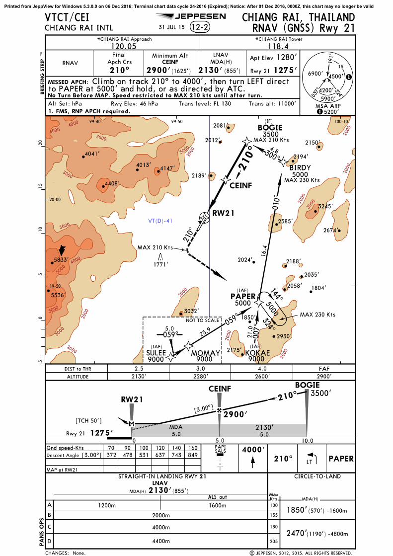
VT(D)-41
2000
2000
2000
3000
3000
3000
3000
4000
4000
4000
5000
5000
2000
2000
2000
2000
3000
2000
2000
3000
191^
037^
6900'
4200'
PA
NS O
PS
CHIANG RAI, THAILANDCHIANG RAI INTL 12-2
*CHIANG RAI Approach
120.05 118.4Final
Apch Crs
210^ 2900'(1625')
MDA(H)Apt Elev 1280'
1275'Rwy 21
MISSED APCH:
PAPI
Trans alt: 11000'
VTCT/CEI
4000'
Alt Set: hPa Rwy Elev: 46 hPa Trans level: FL 130
324^
4500'
BRIE
FIN
G S
TRIP
TM0
55
1015
20
210^
*CHIANG RAI Tower
RNAV (GNSS) Rwy 21
1. FMS, RNP APCH required.
RNAVMinimum Alt LNAV
2130' (855')
[3.00^]
[TCH 50']
3500'210^
2130'MDA
2900'
1
15200'
5900'
CIRCLE-TO-LAND
A
B
C
D
MaxKts MDA(H)
STRAIGHT-IN LANDING RWY 21LNAV
2470'
MDA(H) 2130'
(1190')
1850'
(855')ALS out
(570')
15
SULEE MOMAY KOKAE
PAPER
BIRDY
BOGIE324^
144^
059^5.0
(IAF)
NOT TO SCALE
90009000 9000
(IAF)
059^
23.9
RW21
007^
21.0
010^
16.4
5000
(IAF)
300^
4.8
210^
5000
19-50
20-00
99-40 99-50 100-10
210^
Climb on track 210^ to 4000', then turn LEFT direct
(IF)
SALS
31 JUL 15
JEPPESEN
5000
| JEPPESEN, 2012, 2015. ALL RIGHTS RESERVED.
to PAPER at 5000' and hold, or as directed by ATC.
LT PAPER
CEINF
CEINF
No Turn Before MAP. Speed restricted to MAX 210 kts until after turn.
3032'
2058'
2150'
2189'
5536'
2081'
2012'
4013'
3245'
4408'
2930'
4147'
2585'
2024' 2188'
2175'
1804'
2194'
1850'
2674'
4041'
5833'1771'
MAX 230 Kts
MAX 210 Kts
MAX 210 Kts
MAX 230 Kts
2035'
MSA ARP
3500
Gnd speed-KtsDescent Angle
70 90 100 120 140 160372 478 531 637 743 849
MAP at RW21
[3.00^]
1200m 1600m
2000m
4000m
4400m
-1600m
-4800m
None.
2130'2.5 3.0 4.0 FAF
ALTITUDE 2280' 2600' 2900'DIST to THR
CHANGES:
5.0 5.0Rwy 2110.05.00
RW21
1275'
135
180
205
100
CEINF BOGIE
Printed from JeppView for Windows 5.3.0.0 on 06 Dec 2016; Terminal chart data cycle 24-2016 (Expired); Notice: After 01 Dec 2016, 0000Z, this chart may no longer be valid

217^
144^
203^
VT(D)-41
2000
2000
2000
2000
2000
3000
3000
3000
4000
4000
5000
2000
2000
2000
3000
3000
3000
191^
037^
6900'
4200'
PA
NS O
PS
CHIANG RAI, THAILANDCHIANG RAI INTL 13-1
*CHIANG RAI Approach
120.05 118.4Final
Apch Crs
031^ 3200'(1920')
MDA(H)
MISSED APCH:
Gnd speed-Kts 70 90 100 120 140 160 PAPIHIALS
Trans alt: 11000'
VTCT/CEI
2600'
Alt Set: hPa Rwy Elev: 46 hPa Trans level: FL 130
324^
4500'
MSA CTR VOR
BRIE
FIN
G S
TRIP
TM0
55
1015
20
MAP at D2.2
*CHIANG RAI Tower
SAMIA
NADAL
D6.5
(IAF)
031^
7000
(IF)
Minimum AltD6.5
1830' (550')
CHIANG RAI
116.5 CTRCTR
D
4500' 031^
2000'MDA
3200'
1
15200'
5900'
CIRCLE-TO-LAND
A
B
C
D
MaxKts MDA(H)
STRAIGHT-IN LANDING RWY 03
2470'
MDA(H) 1830'
(1190')
1850'
(550')ALS out
(570')
Descent Angle 372 478 531 637 743 849
19-40
19-50
20-00
99-40 100-10
15
076^3.5
CAREN
6000
14 D
ME
Arc
(IAF)
TIGERR-053/D14.0
9000NOT TO SCALE
031^5.4
VOR Rwy 03
VORCTR
116.5
1. DME required.
CAMMY
CAMMY
4000'3700'
D2.2
VOR
[FS~3]
[MS~3]
[FS~3]
[MS~3]
Climb STRAIGHT AHEAD to 2600', then turn RIGHT
D11.0
D14.0
D19.4
D11.0D14.0
RT CHABUCTR
116.5R-172
99-50
28 AUG 15
JEPPESEN
| JEPPESEN, 2000, 2015. ALL RIGHTS RESERVED.
to intercept CTR VOR R-172 outbound and proceed to CHABU at4500' and hold, or as directed by ATC.
4500
172^
MAX 230 kts
14.0
352^ 2
4500
CHABU(IAF)
PERSY
7000
2
KANOK(IAF)
45006000
GOFFY(IAF)
172^
D12.0D16.0
D16.0
MAX 230 Kts
031^
211^
D22.0
MAX 230 kts
6000
No Turn Before MAP. Speed restricted to MAX 230 kts until after turn.
3032'
2058'
2035'
3032'
2189'
5536'
4013'
3245'
4408'
2930'
3077'
4147'
2585'
2024' 2188'
2175'
1804'
1850'
2674'
5833' 1771'
4500
R-172/D30.0
2200m 3000m
-3000m
-4800m
Apt Elev 1280'
Rwy 1280'
TCH 54'
3.00^
3.00^
Visibilities.
ALTITUDE
5.0 4.0 3.0 2.22405'2720' 2090' 1830'
6.03035'
FAF3200'
CTR VOR DME
CHANGES:
4.34.5
D6.5
D2.2
135
180
205
100
3.0 1.6 Rwy 1280'
NADAL
Printed from JeppView for Windows 5.3.0.0 on 06 Dec 2016; Terminal chart data cycle 24-2016 (Expired); Notice: After 01 Dec 2016, 0000Z, this chart may no longer be valid

144^
053^
217^
172^
039^
VT(D)-41
2000
2000
2000
2000
2000
2000
2000
2000
2000
3000
3000
3000
4000
5000
5000
2000
191^
037^
6900'
4200'
CHIANG RAI, THAILANDCHIANG RAI INTL 13-2
*CHIANG RAI Approach
120.05 118.4Final
Apch Crs
209^ 2900'(1625')
MDA(H)
MISSED APCH:
Gnd speed-Kts 70 90 100 120 140 160 PAPI
Trans alt: 11000'
VTCT/CEI
4000'
Alt Set: hPa Rwy Elev: 46 hPa Trans level: FL 130
324^
4500'
MSA CTR VOR
BRIE
FIN
G S
TRIP
TM0
55
1015
20
MAP at D1.0
*CHIANG RAI Tower
Minimum AltD6.0
2160' (885')
4000'
2160'MDA
2900'
1
1 5200'
5900'
CIRCLE-TO-LAND
A
B
C
D
MaxKts MDA(H)
STRAIGHT-IN LANDING RWY 21
2470'
MDA(H) 2160'
(1190')
1850'
(885')ALS out
(570')
15
Descent Angle 372 478 531 637 743 849
PAPER
WAWEE
D6.0
324^144^5000
(IAF)
209^
500019-50
20-00
99-40 99-50 100-00 100-10
VOR Rwy 21
CHIANG RAI
CTR
D
VORCTR
116.5
1. DME required.
(IAF)
8000
PHUFA
(IAF)
PANIT
6000
PUKKY
4500
11 DME Arc
11D
ME
Acr
(IF)
VOR
116.5 CTR
[FS21]
[FS21]
[RW21]
[RW21]
Climb STRAIGHT AHEAD to 4000', then turn LEFT
D11.0
D11.0
CHIANG RAI277 CTCT
D11.0
D11.0
D11.0
PA
NS O
PS
SALS CTR
116.5R-144
PAPER
209^
28 AUG 15
JEPPESEN
| JEPPESEN, 2012, 2015. ALL RIGHTS RESERVED.
to intercept CTR VOR R-144 outbound and proceed to PAPER at5000' and hold, or as directed by ATC.
LT
3032'
2058'
2150'
2189'
5536'
2081'
2012'
4013'
3245'
4408'
2930'3077'
4147'
2585'
2024'2188'
2175'
1804'
2194'
1850'
2674'
4041'
5833'1771'
MAX 210 Kts
2035'
Apt Elev 1280'
Rwy 1275'
3.00^
TCH 50'
3.00^
2000m
4400m
4800m
- 2000m
- 4800m
Visibilities.
2160'3.6 4.0 5.0 FAF
ALTITUDE 2280' 2600' 2900'CTR VOR DME
CHANGES:
5.0 5.0
D6.0
D1.0
135
180
205
100
D1.0
Rwy 1275'
WAWEED11.0
Printed from JeppView for Windows 5.3.0.0 on 06 Dec 2016; Terminal chart data cycle 24-2016 (Expired); Notice: After 01 Dec 2016, 0000Z, this chart may no longer be valid

JEPPESEN
VT(D)-41
352^CT
277036^
CT277
2000
2000
2000
3000
2000
3000
4000
2000
3000
4000
5000
5000
6000
6000
D7.0
D12.0
D12.0D7.0
CHIANG RAI
CT
CHIANG RAI116.5 CTRCTR
D
D4.5
D1.8
D4.5D1.8
CHIANG RAI, THAILANDCHIANG RAI INTL NDB DME Rwy 0316-1
*CHIANG RAI Approach *CHIANG RAI Tower
120.05 118.4NDB
277CT
FinalApch Crs
025^
Minimum Alt
3400'(2120')
MDA(H)
1700'(420')
Apt Elev 1280'
1280'Rwy 03
MISSED APCH:
MSA CTR VOR
100
135
180
205
Descent Gradient 5.4% 383 492 547 656 766 875Gnd speed-Kts 70 90 100 120 140 160
025^CT
277
19-40
19-50
20-00
99-40 99-50 100-00
05
510
1520
BRIE
FIN
G S
TRIP
TM
on
PAPIHIALS
Climb on track 025^ to CT NDB, then climb on 040^bearing to 2500' within CTR 5 DME, then turn RIGHT to CT NDB and
9 NOV 12 .Eff.15.Nov.
None. | JEPPESEN, 2000, 2012. ALL RIGHTS RESERVED.
3245'
2768'
2930'
2677'
2192'
3077'
2792'
2585'
2024' 2188'
2175'
2107'
1851'
4902'
2136'
1831'
2084'
2848'
5536'
1930'
2602'
2599'
2195'
1874'
1693'
4295'
2320'
1707'
3190'
5775'
3406'
1850'
VTCT/CEI
D7.0
continue climb to 4500' on 205^ bearing to D7.0 and hold.Alt Set: hPa Rwy Elev: 46 hPa Trans level: FL 130 Trans alt: 11000'
MAP at D1.8
277 CT
040^
205^
4500
025^
4500
(IF)
045^
4500
(IAF)
(IAF)
13.0
328^
16.0
MANEE
TANAR
270^
180^
360^
7000'6100'
5700'
A
B
C
D
MaxKts MDA(H)
MDA(H)1700'(420')
ALS out
2.2 km1.4 km
STRAIGHT-IN LANDING RWY 03 CIRCLE-TO-LAND
(590')1870'1970' (690')
-2.4 km-3.6 km
-2.2 km1800' (520')
2.7
4500' 025^
NDB
Rwy 03 1280'
3400'
5.0
1.8 km
2.01770'2100'
3.04.02425'2755'
5.0ALTITUDECTR DME
2.5 1.2
2590'
CHANGES:
CAT C & D AircraftCircling to the Right Only
D25.0
D25.0
PA
NS O
PS
Printed from JeppView for Windows 5.3.0.0 on 06 Dec 2016; Terminal chart data cycle 24-2016 (Expired); Notice: After 01 Dec 2016, 0000Z, this chart may no longer be valid


