
1 Copyright © 2011, Oracle and/or its affiliates. All rights
reserved.
Industrialization of Geospatial Workflows: Building
Industrial Strength Cybersystem / IT Base Platforms
Steven Hagan, Vice President, Server Technologies
2 Copyright © 2012, Oracle and/or its affiliates. All rights
reserved.
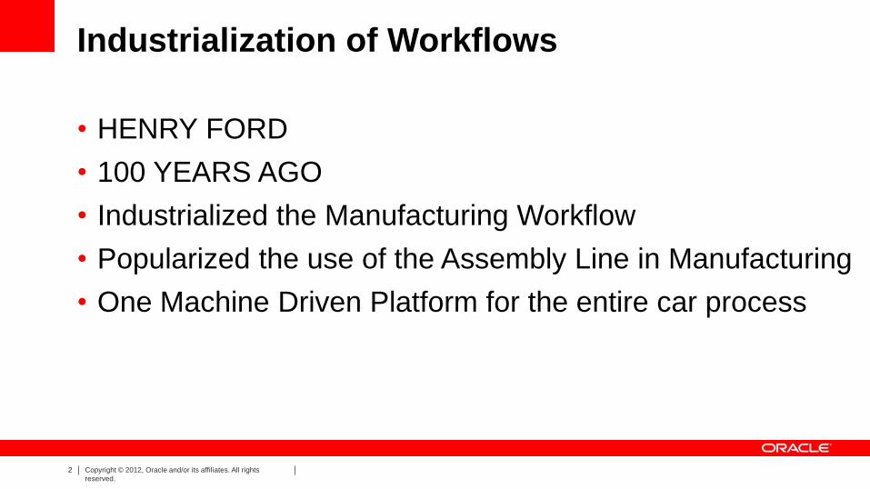
Industrialization of Workflows
• HENRY FORD
• 100 YEARS AGO
• Industrialized the Manufacturing Workflow
• Popularized the use of the Assembly Line in Manufacturing
• One Machine Driven Platform for the entire car process

3 Copyright © 2012, Oracle and/or its affiliates. All rights
reserved.
• Technology Trends in Data Creation, Maintenance, and Management
• Reliance on ‘big data’ technologies
• The right information at the right time
• Machine-processable descriptions of data.
• Semantic technologies will play an important role
• Skills and Training: train the individuals is at least five years
• Requirement for enhanced data management systems
Future Trends
United Nation Analysis – September 2013 Initiative on Global GeoSpatial Information Management

4 Copyright © 2011, Oracle and/or its affiliates. All rights
reserved.
The number of actors involved in generating, managing and
providing geospatial information has increased significantly in
the last ten years and … [this will] continue and … accelerate in
the coming five to ten years.
UN Initiative on Global Geospatial Information
Management
July 2013
Government Crowd Sourcing Sensors/Machines Business … Future
5 Copyright © 2011, Oracle and/or its affiliates. All rights
reserved.
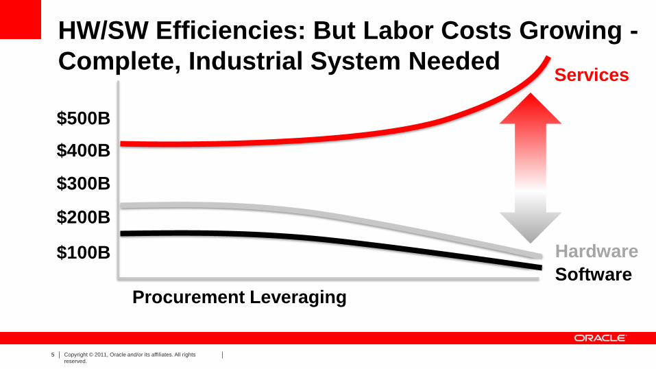
HW/SW Efficiencies: But Labor Costs Growing -
Complete, Industrial System Needed Services
Hardware
Software
Procurement Leveraging
$100B
$200B
$300B
$400B
$500B

6 Copyright © 2012, Oracle and/or its affiliates. All rights
reserved.
Spatial Technology Platform Evolution
• Compass, telescope, sexton, paper maps
• Mainframe computers
• GIS Systems, Workstations
• GeoEnabled Infrastructure:
LiDAR, Mobile, Stream Processing,
Sensors, Cloud Computing
• Industrial Quality Platform
Geographic Information Systems rely on the technology of the era
7 Copyright © 2012, Oracle and/or its affiliates. All rights
reserved.
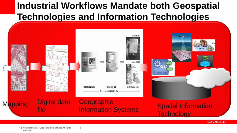
Industrial Workflows Mandate both Geospatial
Technologies and Information Technologies
Mapping Digital data
file Spatial Information
Technology
SOA
Geographic
Information Systems

8 Copyright © 2012, Oracle and/or its affiliates. All rights
reserved.
1. Fraud Prevention
2. Maintenance & Utilities
3. Constituent Sentiment
4. Threat Identification
5. Economic Analysis
6. Healthcare
7. Regulatory Compliance, Licensing & Enforcement
8. Open Government
9. Tax Collections
Big Data / Spatial in Public Sector Examples of Different Program Areas
8
Use Cases

9 Copyright © 2012, Oracle and/or its affiliates. All rights
reserved.
Global Digital Data Growth: Far Exceeds Storage Mfg Volume Growing leaps and bounds by 40+% YoY!
YOU Must Make Policy Decisions on What Data to Keep
Structured Data
Unstructured Data
2009 = .8 Zetabytes = .08 ZB Structured Data
= .72 ZB Unstructured Data 2020 = 35 Zetabytes = 3.5 ZB Structured Data
= 31.5 ZB Unstructured Data*
• Chart conservatively assumes a constant 9:1 ratio of unstructured data vs. structured data (based upon IDC’s estimate that 90% of all digital data is unstructured).
• Chart does not reflect IDC’s projection that unstructured data is currently growing twice as fast as structured data at the rate of 63.7% vs. 32.3% CAGR.
(1 Zetabyte = 1 Trillion Gigabytes)
LEGEND
Source: IDC Digital Universe Study, A Digital Universe Decade – Are Your Ready?, 2010

10 Copyright © 2011, Oracle and/or its affiliates. All rights
reserved.

11 Copyright © 2012, Oracle and/or its affiliates. All rights
reserved.
Detecting Signal in Noise = New Insight
Signal
Noise
.................…
Insight
What’s the effectiveness of a
re-employment campaign? How
has it effected the economy
Can I track certain suspicious
individuals?
What do citizens think about policies & services?
Can we detect issues and trends before liabilities
increase?
How can sensor data improve maintenance efforts for key
assets?

12 Copyright © 2011, Oracle and/or its affiliates. All rights
reserved.
Industrialization of Geospatial Workflows: Drivers:
• BIG DATA GENERATION: – Terabytes, Petabytes, Exabytes, Zettabytes, Yottabytes
– Sensors, RFID, VIDEO, LIDAR, Raster, 3D, INTERNET OF THINGS
– SDIs, INSPIRE, Terrain and City Models
– Social Media, Tagged Data, History / Archive / Version Data
– Linked Open Data –- Persistent Relationships, Semantics, Ontologies
• BIG but Inexpensive Hardware:
– CLOUD Platforms – Public and Private
– More powerful – Clusters of Commodity Servers, Virtualization: = Greener
– Massively parallel database machines – Software Enablement – e.g. Hadoop
• BIG Software & INDUSTRIAL WORKFLOWS
– Location Enable All Applications: ERP, CRM, Business Intelligence, Public Sectors
– REAL TIME Analytics –Biggest value from fastest response – Streams and Events –- Spatially Aware System – no separate GIS
– CyberSecurity, Encryption, Privacy
– Support Standards – W3C, OGC, ISO, Wide Range
13 Copyright © 2011, Oracle and/or its affiliates. All rights
reserved.
• DATA / INFORMATION –
– Too much to store it all
– Arriving too fast for humans to process – Need Automated Workflows
– Must use Real Time Filtering and Analytics
- This is the Big Data / Hadoop filtering & CEP - Complex Event Processing
- Set policies on what to keep, what to expunge
– Must share data among your many Organizations, enabling Aggregation
• Geography/Mapping/Location, Health Care, Statistics, Commerce, Taxation
– SHARING requires Interoperability and Semantics / Ontologies / LOD
• This is a DATA MANAGEMENT TOPIC, not a GIS issue.
Big, Fast, Aggregation & Workflows =
SHAREABLE, REPURPOSABLE LOCATION DATA
14 Copyright © 2011, Oracle and/or its affiliates. All rights
reserved.
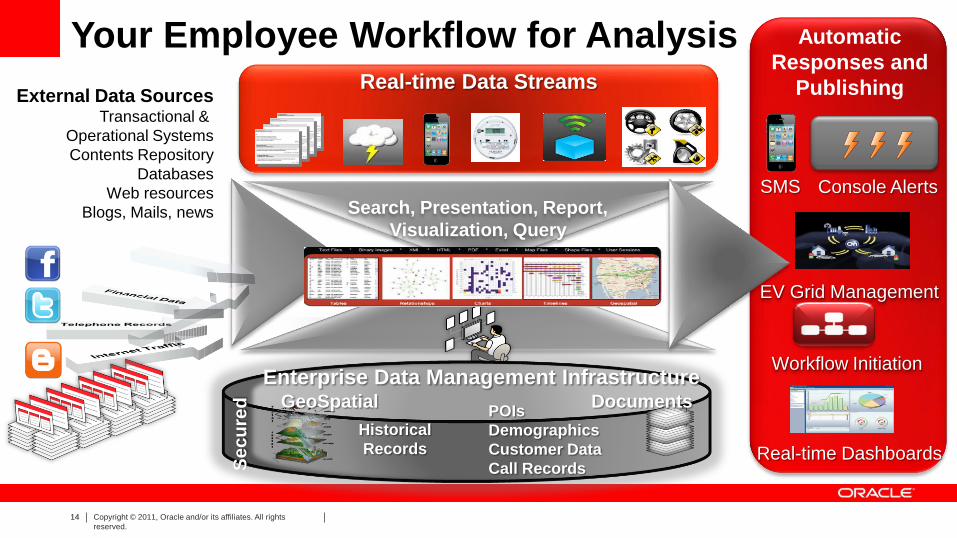
Real-time Data Streams
External Data Sources Transactional &
Operational Systems
Contents Repository
Databases
Web resources
Blogs, Mails, news Search, Presentation, Report,
Visualization, Query
Your Employee Workflow for Analysis
Enterprise Data Management Infrastructure GeoSpatial Documents
Se
cu
red
Historical
Records
POIs
Demographics
Customer Data
Call Records
SMS
Workflow Initiation
Real-time Dashboards
Console Alerts
EV Grid Management
Automatic
Responses and
Publishing
15 Copyright © 2012, Oracle and/or its affiliates. All rights
reserved.
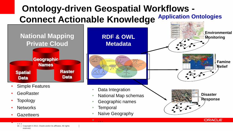
Ontology-driven Geospatial Workflows -
Connect Actionable Knowledge
• Simple Features
• GeoRaster
• Topology
• Networks
• Gazetteers
• …
RDF & OWL
Metadata
Environmental
Monitoring
Famine
Relief
National Mapping
Private Cloud
Disaster
Response
Spatial
Data
Geographic
Names
Raster
Data
• Data Integration
• National Map schemas
• Geographic names
• Temporal
• Naïve Geography
• …
Application Ontologies
16 Copyright © 2012, Oracle and/or its affiliates. All rights
reserved.
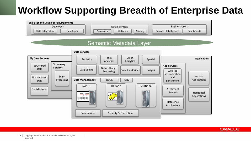
Big Data Sources Applications
End-user and Developer Environments
Streaming Services
Data Services
Statistics Text
Analytics Graph
Analytics Spatial
Data Mining Natural Lang.
Processing
Structured Data
Unstructured Data
App Services
Developers
Data Integration
Business Users
Business Intelligence
Data Scientists
Discovery
Event Processing Data Management
NoSQL Relational Hadoop
Web-log Sessionization
and Enrichment
Sentiment Analysis
Social Media
Statistics Mining
Workflow Supporting Breadth of Enterprise Data
JDeveloper Dashboards
Reference Architecture
Sound and Video Images
Compression Security & Encryption
Vertical Applications
Horizontal Applications
ODBC JDBC
Semantic Metadata Layer

17 Copyright © 2012, Oracle and/or its affiliates. All rights
reserved.
Buzzwords For Apps & Workflows using
Graph Technology: What terms to look for:
• Semantic Web
• W3C RDF/OWL/SPARQL
• Graph Data Management
• Social Network Analysis (SNA)
• Knowledge Discovery
• Knowledge Mining
• Big Data
• Taxonomy/Terminology Mgmt
• Faceted Search
• Inferencing / Reasoning
• Property Graphs
• Sentiment Analysis
• Text Mining
• NoSQL Database

18 Copyright © 2011, Oracle and/or its affiliates. All rights
reserved.
You Get Order And Efficiency Using Standards
• ISO – TC 211 – TC 204
• Open Geospatial Consortium
– Simple Features – GML – Web Services
• De-facto Standards – SHP, MGE, DXF, KML
• Professional Standards
– ISPRS, FIG, WMO
• Java, .NET, Flash
• TAGGED METADATA – agree on tags
SQL3/MM Spatial
"We intend to complete development for a new suite of tools for developing the next generation of
applications. And there are several interesting things with the next generation of tools, but
perhaps the single most interesting thing about them is that for the first time a major application
company is going to commit to an absolute standards-based development environment.“
– Larry Ellison

19 Copyright © 2012, Oracle and/or its affiliates. All rights
reserved.
Oracle Spatial and Graph
“Points” “Lines” “Polygons”
Rasters
Topologies
3D f1
f2 n1 n2
e1
e2 e3
e4
Network Graphs
Web Services
(OGC) Geocoding
Routing
RDF Semantic Graphs
Oracle Spatial and Graph option
“Points”
Web Services
(OGC)
SPARQL End Point
Geocoding
Routing
Inferencing
20 Copyright © 2012, Oracle and/or its affiliates. All rights
reserved.
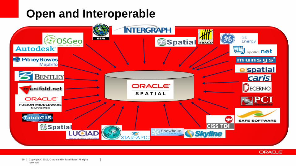
Open and Interoperable
Data

21 Copyright © 2012, Oracle and/or its affiliates. All rights
reserved.
SIMPLIFY WORKFLOWS – AUTOMATE IT
•SIMPLIFY BASIC
PARTS OF
WORKFLOWS
• YOUR PLATFORM
MUST AUTOMATE
STANDARD IT ACTIONS

22 Copyright © 2012, Oracle and/or its affiliates. All rights
reserved.
Connecting: CYBERSECURITY is Major Challenge
Information Security and Privacy
Monitoring
Access Control
Encryption & Masking
Monitoring •Configuration Management
•Audit Vault
•Total Recall Access Control
•Database Vault
•Label Security
•Advanced Security
•Secure Backup
•Data Masking
Encryption & Masking
Blocking & Logging
Oracle Database
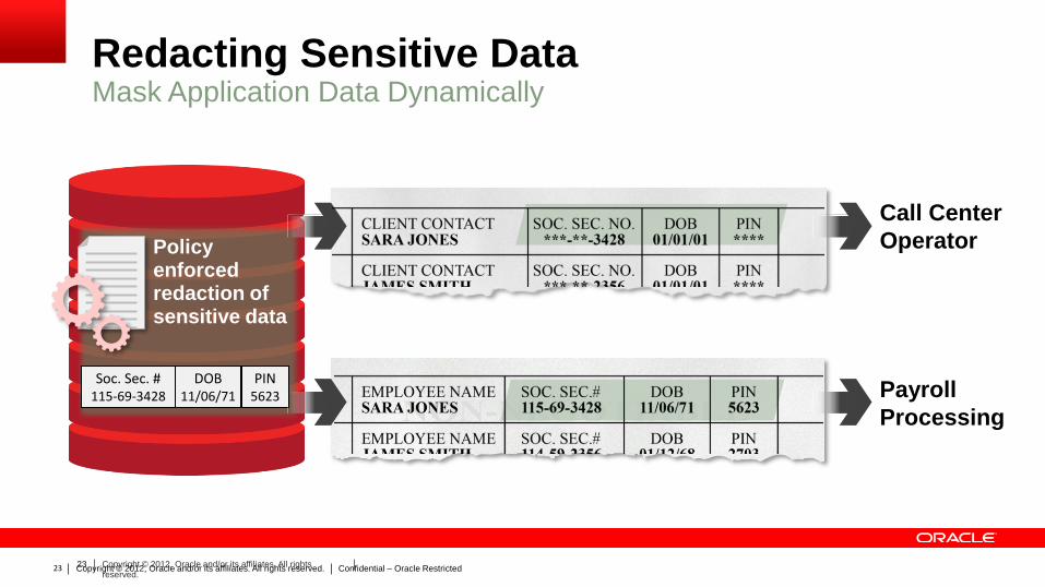
23 Copyright © 2012, Oracle and/or its affiliates. All rights
reserved. Copyright © 2012, Oracle and/or its affiliates. All rights reserved. Confidential – Oracle Restricted 23
Soc. Sec. # 115-69-3428
DOB 11/06/71
PIN 5623
Policy enforced redaction of sensitive data
Redacting Sensitive Data Mask Application Data Dynamically
Call Center
Operator
Payroll
Processing
24 Copyright © 2012, Oracle and/or its affiliates. All rights
reserved.
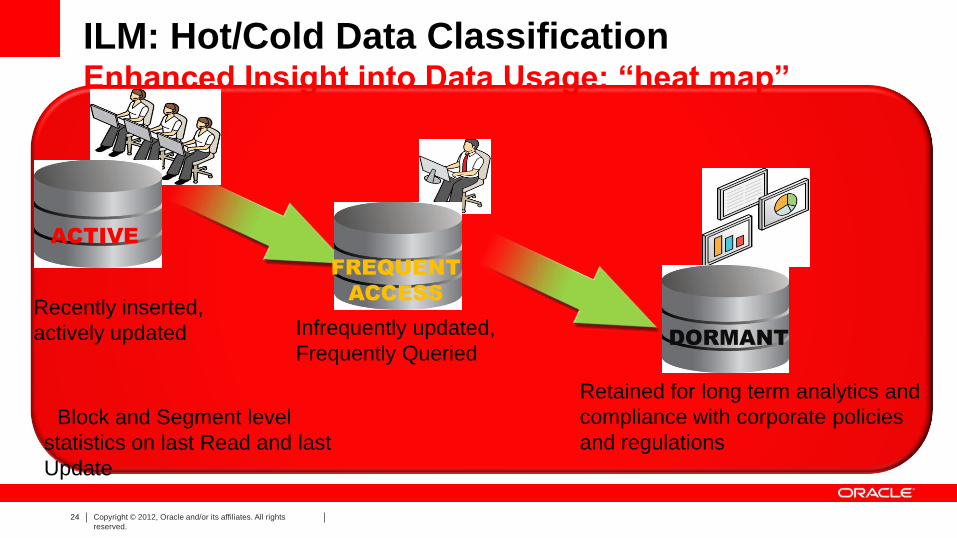
ILM: Hot/Cold Data Classification Enhanced Insight into Data Usage: “heat map”
Recently inserted,
actively updated Infrequently updated,
Frequently Queried
Retained for long term analytics and
compliance with corporate policies
and regulations
ACTIVE
FREQUENT
ACCESS
DORMANT
• Block and Segment level
statistics on last Read and last
Update
25 Copyright © 2012, Oracle and/or its affiliates. All rights
reserved. Copyright © 2012, Oracle and/or its affiliates. All rights reserved. Confidential – Oracle Restricted 25
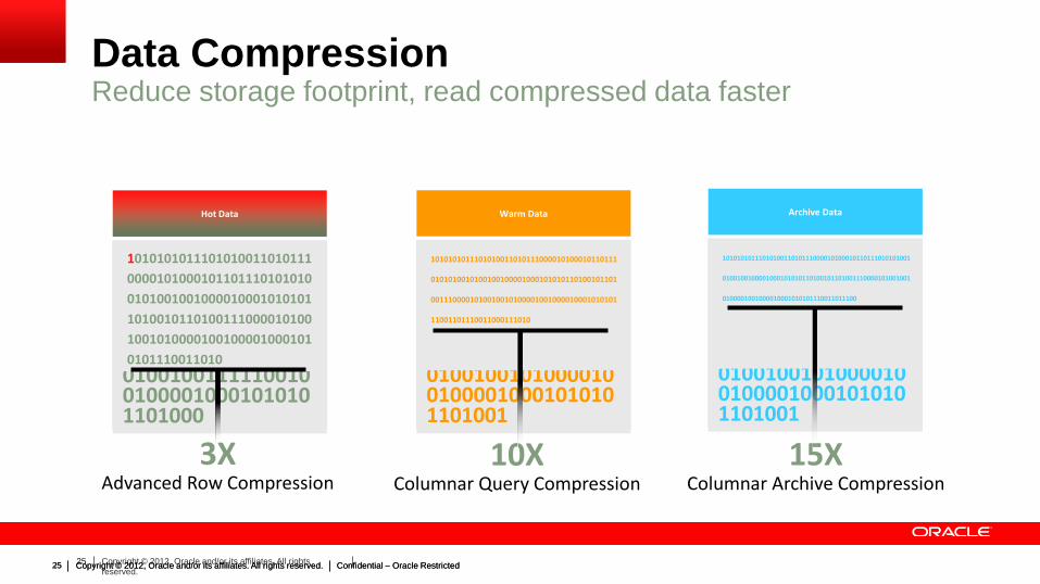
Data Compression Reduce storage footprint, read compressed data faster
Hot Data
Copyright © 2012, Oracle and/or its affiliates. All rights reserved. Confidential – Oracle Restricted 25
111010101010101001101010101011010001011011000110100101000001001110001010101101001011010010110001010010011111001001000010001010101101000
1010101011101010011010111
0000101000101101110101010
0101001001000010001010101
1010010110100111000010100
1001010000100100001000101
0101110011010
Warm Data
101010101110101001101011100001010001011011101010100101001001000010001010101101001011010011100001010010010100001001000010001010101101001
1010101011101010011010111000010100010110111
0101010010100100100001000101010110100101101
0011100001010010010100001001000010001010101
11001101110011000111010
Archive Data
101010101110101001101011100001010001011011101010100101001001000010001010101101001011010011100001010010010100001001000010001010101101001
1010101011101010011010111000010100010110111010101001
0100100100001000101010110100101101001110000101001001
0100001001000010001010101110011011100
3X Advanced Row Compression
10X
Columnar Query Compression
15X
Columnar Archive Compression
26 Copyright © 2011, Oracle and/or its affiliates. All rights
reserved.
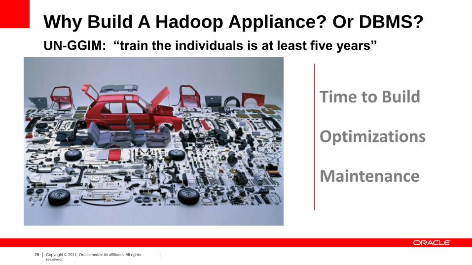
Time to Build Optimizations Maintenance
Why Build A Hadoop Appliance? Or DBMS?
UN-GGIM: “train the individuals is at least five years”
27 Copyright © 2011, Oracle and/or its affiliates. All rights
reserved.
SHUFFLE /SORT
SHUFFLE /SORT
MAP
MAP
MAP
MAP
SHUFFLE /SORT
REDUCE
REDUCE
SHUFFLE /SORT
SHUFFLE /SORT
REDUCE
REDUCE
REDUCE
INPUT 2
INPUT 1
OUTPUT 2
OUTPUT 1
MAP
MAP
MAP
MAP
MAP
REDUCE
REDUCE
REDUCE
MAP
MAP
MAP
MAP
MAP
MAP
REDUCE
REDUCE
MAP
MAP
MAP
MAP
MAP
REDUCE
REDUCE
REDUCE
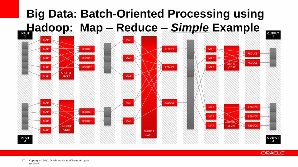
Big Data: Batch-Oriented Processing using
Hadoop: Map – Reduce – Simple Example

28 Copyright © 2012, Oracle and/or its affiliates. All rights
reserved.
Exadata Big Data Appliance Exalytics
Oracle Industrial Geospatial Workflow Platform
ACQUIRE ORGANIZE DECIDE ANALYZE
In-D
atab
ase
An
alyt
ics
Data
Warehouse
Cloudera’s Distribution
including Apache Hadoop
Oracle Big Data Connectors
Analytic
Applications Alerts, Dashboards, MD-Analysis, Reports, Query Web Services BI Abstraction
Applications
Oracle NoSQL
Database
Oracle Data Integrator
Big Data
Appliance
Exadata
Exalytics
Oracle
Advanced
Analytics
InfiniBand InfiniBand
Oracle
Database Open Source R

29 Copyright © 2011, Oracle and/or its affiliates. All rights
reserved.
Public Clouds and Private Clouds
• Used by
multiple
tenants on a
shared basis
• Hosted and
managed by
cloud service
provider
• Exclusively
used by a
single
organization
• Controlled and
managed by
in-house IT
Lower upfront costs
Outsourced management
OpEx
Lower total costs
Greater control over security, compliance, QoS
CapEx & OpEx
Trade-offs
Public Clouds
IaaS
PaaS
SaaS I
N
T
R
A
N
E
T
Private Cloud
IaaS
PaaS
SaaS I
N
T
E
R
N
E
T
IaaS
PaaS
IaaS
PaaS
Apps SaaS
Oracle Technology Supplies both Public and Private clouds

30 Copyright © 2012, Oracle and/or its affiliates. All rights
reserved.
– Spatial analytics in Applications and
tools
– Fusion Middleware MapViewer, Event
Processing
– Oracle Spatial and Graph database
– Bundled and Cloud-based Map Content
– Designed for Exadata
Built-in Geospatial features
Oracle’s Spatial Stack

31 Copyright © 2011, Oracle and/or its affiliates. All rights
reserved.
Industrialization of Geospatial Workflows:
Best Success Requires Complete Platforms
Deep
Analytics
Simplified IT
Big Data
Big & Fast Data
Volunteered
Geographic
Information
Sensors
Streaming Data
Geo-
referenced
Video,
3D, LiDAR
Simplified Spatial IT
Support for
Open Standards
Spatial Database,
Application Server,
BI, tools
Support by
Leading Partner
solutions
Spatially-
enabled
Engineered
Systems
Deep
Analytics
Real-time Spatial
Event Processing
Dense
Visualization
Spatial Analysis
On Premise,
On Cloud,
Shared
Services
On Premise,
On Cloud,
Shared
Services
Shared GeoSpatial Services
Location Aware Everything

32 Copyright © 2011, Oracle and/or its affiliates. All rights
reserved.
32 Copyright © 2011, Oracle and/or its affiliates. All rights
reserved.
Insert Information Protection Policy Classification from Slide 8
Cloud
Computing
Oracle Engineered
Systems


