Hydrology
River Ecosystems and Humans

Dimensions of river ecosystems
• Longitudinal
• Lateral
• Vertical
• Temporal
2
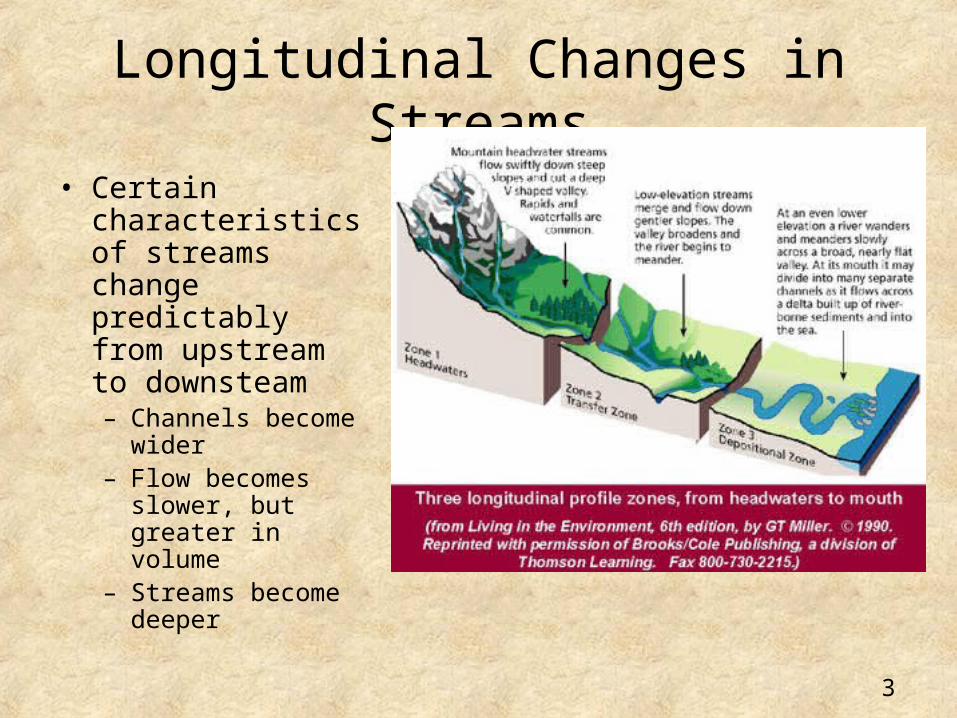
Longitudinal Changes in Streams
• Certain characteristics of streams change predictably from upstream to downsteam– Channels become
wider– Flow becomes
slower, but greater in volume
– Streams become deeper
3

Longitudinal Changes – Reach Scale
• Longitudinal changes are also observed at shorter scales than the entire river length
• We call this shorter scale the “reach” scale
• One example of reach scale changes is the pool-riffle pattern found in many streams draining areas with medium gradient
• Riffle is an area of rapid flow over coarse substrate (rocks) whereas the pool is a slower flowing stretch with finer substrate
• Path of flow - thalweg
4

Lateral Patterns• There are also some
predictable changes laterally
• The stream has a low flow channel; the fastest flow is called the thalweg
• The stream has banks which define its frequent flow limit
• The stream has a floodplain which defines its flow limit on less frequent events, annual or lesser frequency
5

Lateral Patterns
• Some streams and rivers will have a single dominant channel while others will have a network of interwoven channels
6
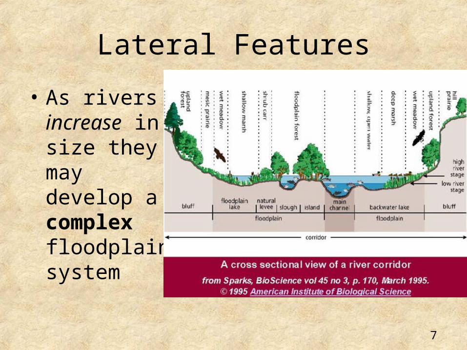
Lateral Features
• As rivers increase in size they may develop a complex floodplain system
7
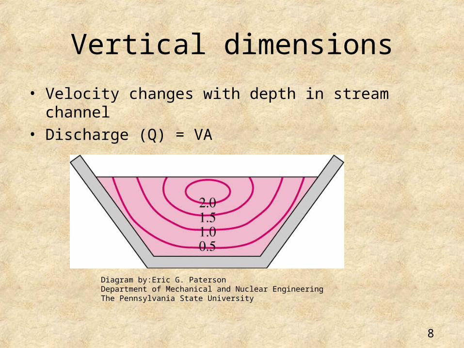
Vertical dimensions
• Velocity changes with depth in stream channel• Discharge (Q) = VA
Diagram by:Eric G. PatersonDepartment of Mechanical and Nuclear EngineeringThe Pennsylvania State University
8

Vertical Features
• Hyporheic (below stream) inter-actions
• Exchanges occur with groundwater just below the stream
9

Lateral and Vertical Patterns
• In many large alluvial valleys, creatures that live in ground water and hyporheic water can be found in the subsurface water kilometers from the stream. In other words the stream extends well beyond its channel.
10

Temporal dimension
• Stream flow changesSecond by secondHourlyDailyMonthlySeasonallyAnnuallyMilleniumly
11
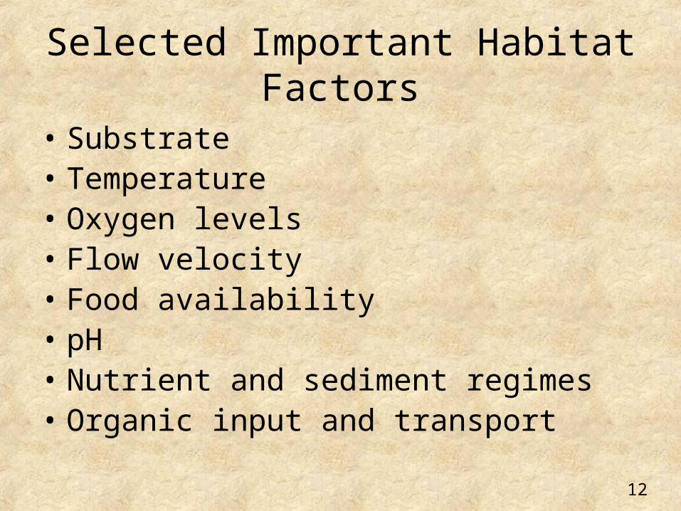
Selected Important Habitat Factors
• Substrate• Temperature• Oxygen levels• Flow velocity• Food availability• pH• Nutrient and sediment regimes• Organic input and transport
12

How are species distributed in space and time?
-- Environments contributing to riverine biodiversity
Surface water Subsurface water Riparian system
Streams
Springs
LakesHyporheic
ZoneGroundWater
ConfinedReaches
UnconfinedReaches
13

River --------------------------------------------- Floodplain Edge
Spatial distribution of species across a floodplain (lateral dimension)
Species Richness
0
50
100
Per
cen
t o
f m
axim
um
ric
hn
ess
fish
Mollusca
Odonata
Amphibia
Macrophytes
(Ward and Tockner 2001 fig. 9.3)
Species Richness
0
100
Eg.FishSnails, slugs, mussels,Dragonflies, damselfliesFrogs, salamanders, toadsAquatic plants
14

How do humans affect watersheds and the hydrologic
cycle?
15

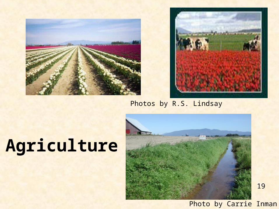
Human caused disturbances
• Agriculture
• Timber harvest
• Mining
• Urbanization
• Introduction of exotic species
• Harvesting of fish and wildlife
16
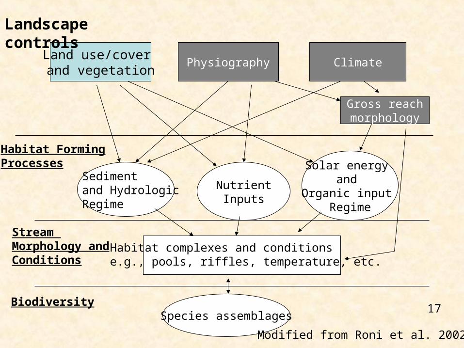
Land use/cover and vegetation
Physiography Climate
Landscape controls
NutrientInputs
Solar energy and
Organic input Regime
Gross reachmorphology
Habitat FormingProcesses
Species assemblages
Stream Morphology andConditions
Biodiversity
Habitat complexes and conditionse.g., pools, riffles, temperature, etc.
Sedimentand HydrologicRegime
Modified from Roni et al. 2002.
17

Physical, chemical, and biological components related to water quality
• Light• Temperature• Dissolved ions• Suspended solids• Nutrients and gases• Toxics such as metals and pesticides/herbicides• Biological features• PPCPs (Pharmaceuticals & Personal Care Products)
18
Photos by R.S. Lindsay
Photo by Carrie Inman
Agriculture
19

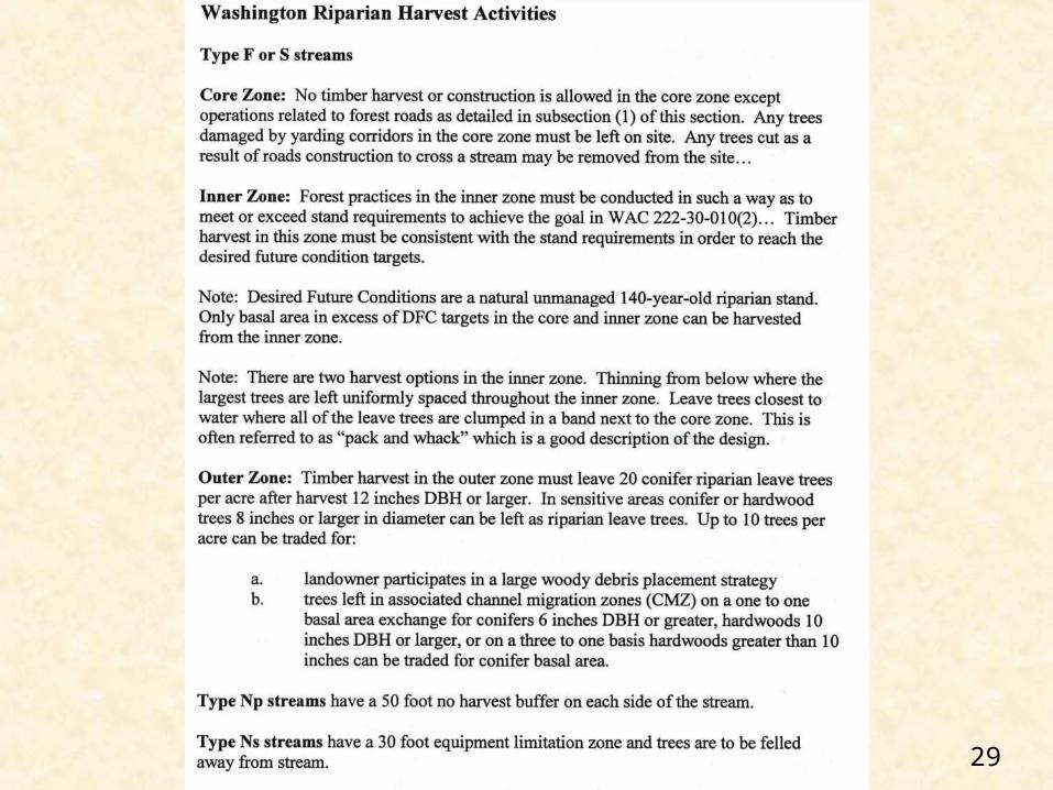
FORESTRY
20

Aggregate Mining
In-channel mining
In-channel and floodplain miningPhotos by M. Kondolf
21

URBANIZATION
22

Forestry, agriculture and urbanization
• Remove trees and other vegetation
• Reduce organic matter delivery
• Build roads
23

Large storage in soil, channel and valley floor Recharge
Natural cleaning
Pollutant wash off
No recharge
Rapid flow limited storage
Slow flow
Natural Developed
Reduced soil storageLimited infiltration
Precipitation
24

Floods and Urbanization
surface runoff vs. infiltrationnatural land cover vs. urban area
25

How do we manage watershed?
• Dept of Natural Resources Regulations
• U.S. Forest Service Regulations
• Clean water act
• Endangered Species Act
• Total Maximum Daily Loads (TMDLs)
26

27

28
29

Take Home Messages
• Understand the interactions between land use/land cover and components of the hydrologic cycle
• Be able to describe what is typically measured in watersheds and why
30

Hydrology Report
~ 2-3 pages due May 25 individually
Include: Name, Date, Title IntroductionMethodsResults and Discussion (w tables) ConclusionsAppendix (if needed for raw calculations)
31


