Order Details
Site DetailsSite at, Lockington, Leicestershire
Order Number:Customer Ref:
National Grid Reference:Slice:Site Area (Ha):Search Buffer (m):
49432360_1_1312494 East Midlands Gateway SRFI - Main Site445410, 326620A231.14250
Tel:Fax:Web:
0844 844 99520844 844 9951www.envirocheck.co.uk
Page 1 of 9A Landmark Information Group Service v47.0 24-Sep-2013
Historical Map - Segment A11
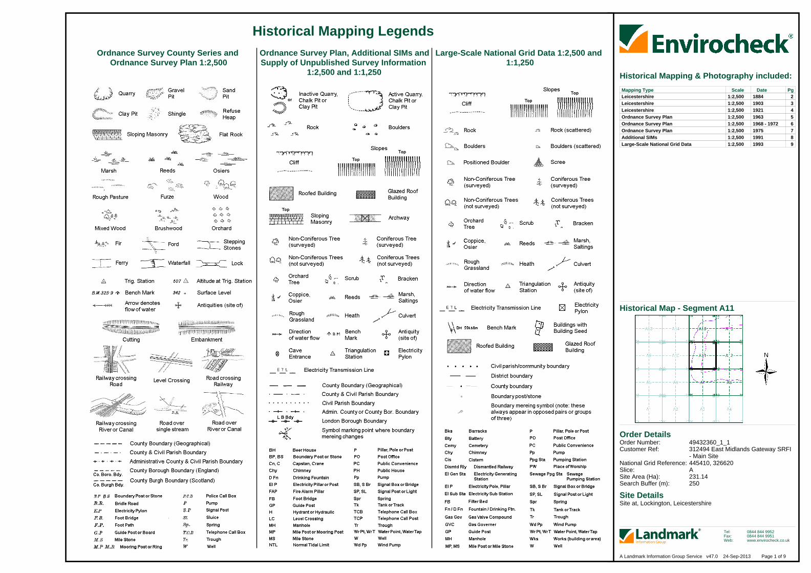
Ordnance Survey County Series and Ordnance Survey Plan 1:2,500
Ordnance Survey Plan, Additional SIMs andSupply of Unpublished Survey Information
1:2,500 and 1:1,250
Large-Scale National Grid Data 1:2,500 and 1:1,250
Historical Mapping Legends
Historical Mapping & Photography included:
LeicestershireLeicestershireLeicestershireOrdnance Survey PlanOrdnance Survey PlanOrdnance Survey PlanAdditional SIMsLarge-Scale National Grid Data
1:2,5001:2,5001:2,5001:2,5001:2,5001:2,5001:2,5001:2,500
18841903192119631968 - 1972197519911993
23456789
Mapping Type Scale Date Pg
Order Details
Site DetailsSite at, Lockington, Leicestershire
Order Number:Customer Ref:
National Grid Reference:Slice:Site Area (Ha):Search Buffer (m):
49432360_1_1312494 East Midlands Gateway SRFI - Main Site445410, 326620A231.14250
Tel:Fax:Web:
0844 844 99520844 844 9951www.envirocheck.co.uk
Page 2 of 9A Landmark Information Group Service v47.0 24-Sep-2013
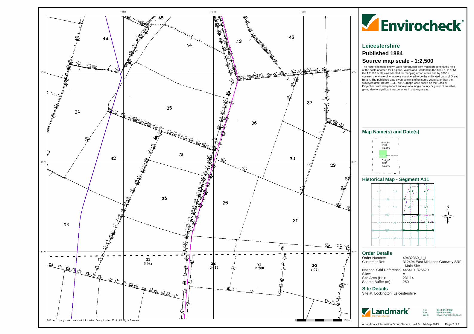
LeicestershirePublished 1884Source map scale - 1:2,500The historical maps shown were reproduced from maps predominantly held at the scale adopted for England, Wales and Scotland in the 1840`s. In 1854 the 1:2,500 scale was adopted for mapping urban areas and by 1896 it covered the whole of what were considered to be the cultivated parts of GreatBritain. The published date given below is often some years later than the surveyed date. Before 1938, all OS maps were based on the Cassini Projection, with independent surveys of a single county or group of counties, giving rise to significant inaccuracies in outlying areas.
Historical Map - Segment A11
Map Name(s) and Date(s)
Order Details
Site DetailsSite at, Lockington, Leicestershire
Order Number:Customer Ref:
National Grid Reference:Slice:Site Area (Ha):Search Buffer (m):
49432360_1_1312494 East Midlands Gateway SRFI - Main Site445410, 326620A231.14250
Tel:Fax:Web:
0844 844 99520844 844 9951www.envirocheck.co.uk
Page 3 of 9A Landmark Information Group Service v47.0 24-Sep-2013
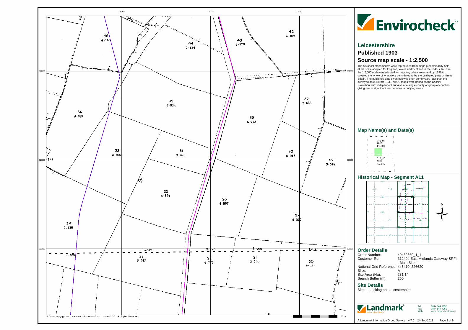
LeicestershirePublished 1903Source map scale - 1:2,500The historical maps shown were reproduced from maps predominantly held at the scale adopted for England, Wales and Scotland in the 1840`s. In 1854 the 1:2,500 scale was adopted for mapping urban areas and by 1896 it covered the whole of what were considered to be the cultivated parts of GreatBritain. The published date given below is often some years later than the surveyed date. Before 1938, all OS maps were based on the Cassini Projection, with independent surveys of a single county or group of counties, giving rise to significant inaccuracies in outlying areas.
Historical Map - Segment A11
Map Name(s) and Date(s)
Order Details
Site DetailsSite at, Lockington, Leicestershire
Order Number:Customer Ref:
National Grid Reference:Slice:Site Area (Ha):Search Buffer (m):
49432360_1_1312494 East Midlands Gateway SRFI - Main Site445410, 326620A231.14250
Tel:Fax:Web:
0844 844 99520844 844 9951www.envirocheck.co.uk
Page 4 of 9A Landmark Information Group Service v47.0 24-Sep-2013
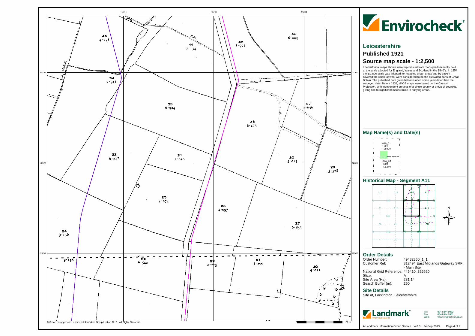
LeicestershirePublished 1921Source map scale - 1:2,500The historical maps shown were reproduced from maps predominantly held at the scale adopted for England, Wales and Scotland in the 1840`s. In 1854 the 1:2,500 scale was adopted for mapping urban areas and by 1896 it covered the whole of what were considered to be the cultivated parts of GreatBritain. The published date given below is often some years later than the surveyed date. Before 1938, all OS maps were based on the Cassini Projection, with independent surveys of a single county or group of counties, giving rise to significant inaccuracies in outlying areas.
Historical Map - Segment A11
Map Name(s) and Date(s)
Order Details
Site DetailsSite at, Lockington, Leicestershire
Order Number:Customer Ref:
National Grid Reference:Slice:Site Area (Ha):Search Buffer (m):
49432360_1_1312494 East Midlands Gateway SRFI - Main Site445410, 326620A231.14250
Tel:Fax:Web:
0844 844 99520844 844 9951www.envirocheck.co.uk
Page 5 of 9A Landmark Information Group Service v47.0 24-Sep-2013
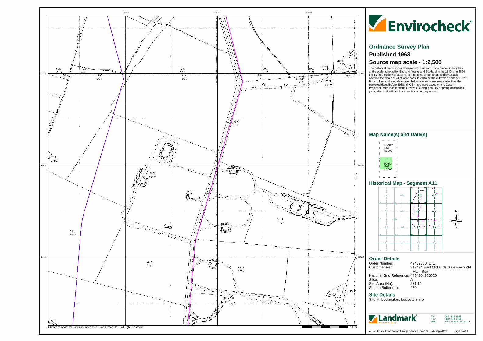
Ordnance Survey PlanPublished 1963Source map scale - 1:2,500The historical maps shown were reproduced from maps predominantly held at the scale adopted for England, Wales and Scotland in the 1840`s. In 1854 the 1:2,500 scale was adopted for mapping urban areas and by 1896 it covered the whole of what were considered to be the cultivated parts of GreatBritain. The published date given below is often some years later than the surveyed date. Before 1938, all OS maps were based on the Cassini Projection, with independent surveys of a single county or group of counties, giving rise to significant inaccuracies in outlying areas.
Historical Map - Segment A11
Map Name(s) and Date(s)

Order Details
Site DetailsSite at, Lockington, Leicestershire
Order Number:Customer Ref:
National Grid Reference:Slice:Site Area (Ha):Search Buffer (m):
49432360_1_1312494 East Midlands Gateway SRFI - Main Site445410, 326620A231.14250
Tel:Fax:Web:
0844 844 99520844 844 9951www.envirocheck.co.uk
Page 6 of 9A Landmark Information Group Service v47.0 24-Sep-2013
Ordnance Survey PlanPublished 1968 - 1972Source map scale - 1:2,500The historical maps shown were reproduced from maps predominantly held at the scale adopted for England, Wales and Scotland in the 1840`s. In 1854 the 1:2,500 scale was adopted for mapping urban areas and by 1896 it covered the whole of what were considered to be the cultivated parts of GreatBritain. The published date given below is often some years later than the surveyed date. Before 1938, all OS maps were based on the Cassini Projection, with independent surveys of a single county or group of counties, giving rise to significant inaccuracies in outlying areas.
Historical Map - Segment A11
Map Name(s) and Date(s)
Order Details
Site DetailsSite at, Lockington, Leicestershire
Order Number:Customer Ref:
National Grid Reference:Slice:Site Area (Ha):Search Buffer (m):
49432360_1_1312494 East Midlands Gateway SRFI - Main Site445410, 326620A231.14250
Tel:Fax:Web:
0844 844 99520844 844 9951www.envirocheck.co.uk
Page 7 of 9A Landmark Information Group Service v47.0 24-Sep-2013
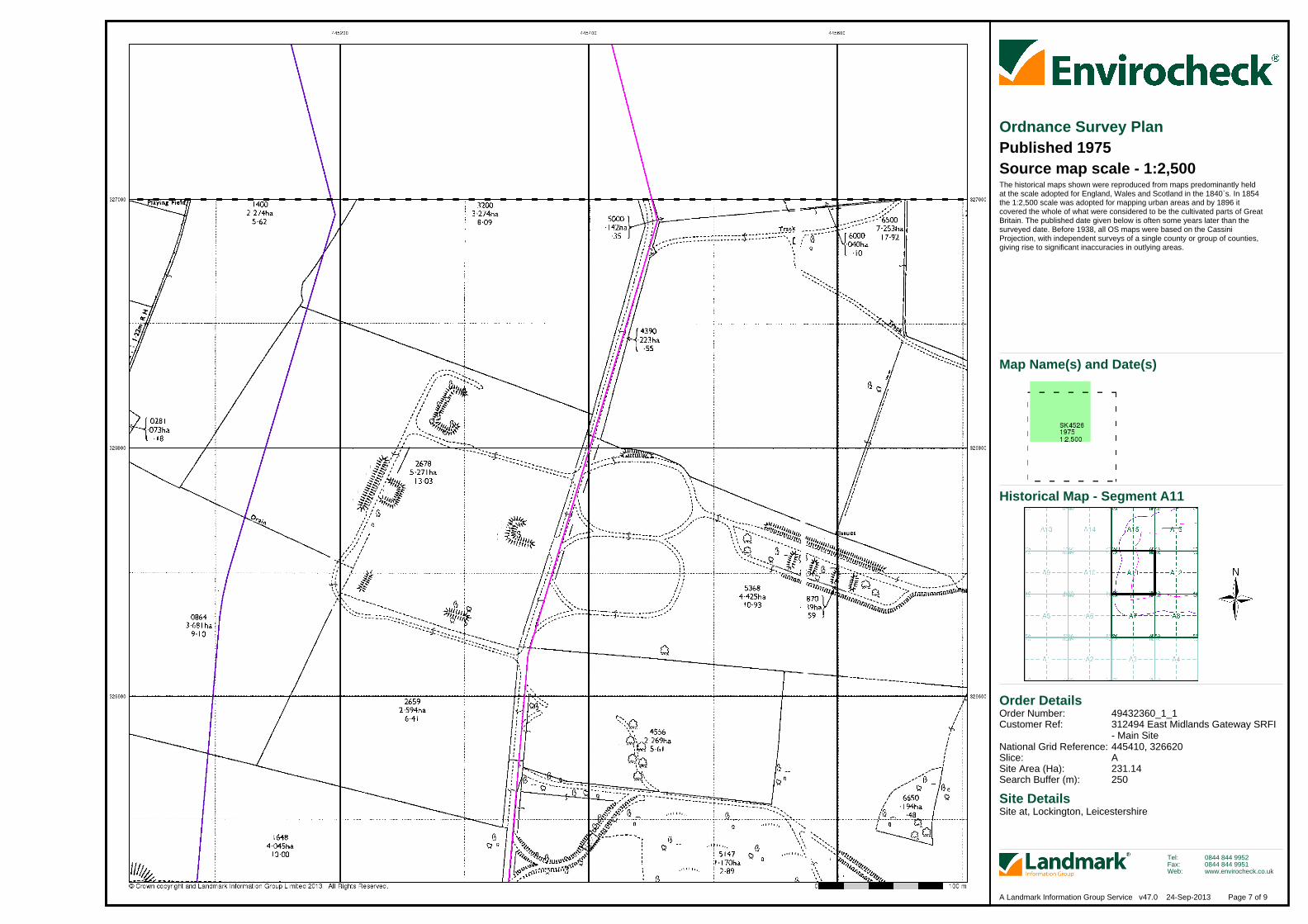
Ordnance Survey PlanPublished 1975Source map scale - 1:2,500The historical maps shown were reproduced from maps predominantly held at the scale adopted for England, Wales and Scotland in the 1840`s. In 1854 the 1:2,500 scale was adopted for mapping urban areas and by 1896 it covered the whole of what were considered to be the cultivated parts of GreatBritain. The published date given below is often some years later than the surveyed date. Before 1938, all OS maps were based on the Cassini Projection, with independent surveys of a single county or group of counties, giving rise to significant inaccuracies in outlying areas.
Historical Map - Segment A11
Map Name(s) and Date(s)

Order Details
Site DetailsSite at, Lockington, Leicestershire
Order Number:Customer Ref:
National Grid Reference:Slice:Site Area (Ha):Search Buffer (m):
49432360_1_1312494 East Midlands Gateway SRFI - Main Site445410, 326620A231.14250
Tel:Fax:Web:
0844 844 99520844 844 9951www.envirocheck.co.uk
Page 8 of 9A Landmark Information Group Service v47.0 24-Sep-2013
Additional SIMsPublished 1991Source map scale - 1:2,500The SIM cards (Ordnance Survey's `Survey of Information on Microfilm') are further, minor editions of mapping which were produced and published in between the main editions as an area was updated. They date from 1947 to 1994, and contain detailed information on buildings, roads and land-use. These maps were produced at both 1:2,500 and 1:1,250 scales.
Historical Map - Segment A11
Map Name(s) and Date(s)

Order Details
Site DetailsSite at, Lockington, Leicestershire
Order Number:Customer Ref:
National Grid Reference:Slice:Site Area (Ha):Search Buffer (m):
49432360_1_1312494 East Midlands Gateway SRFI - Main Site445410, 326620A231.14250
Tel:Fax:Web:
0844 844 99520844 844 9951www.envirocheck.co.uk
Page 9 of 9A Landmark Information Group Service v47.0 24-Sep-2013
Large-Scale National Grid DataPublished 1993Source map scale - 1:2,500'Large Scale National Grid Data' superseded SIM cards (Ordnance Survey's 'Survey of Information on Microfilm') in 1992, and continued to be produced until 1999. These maps were the fore-runners of digital mapping and so provide detailed information on houses and roads, but tend to show less topographic features such as vegetation. These maps were produced at both 1:2,500 and 1:1,250 scales.
Historical Map - Segment A11
Map Name(s) and Date(s)


