
Greening DC Streets

“I want to make the District the healthiest, greenest, and most liveable city in the nation.”
- Mayor Vincent Gray
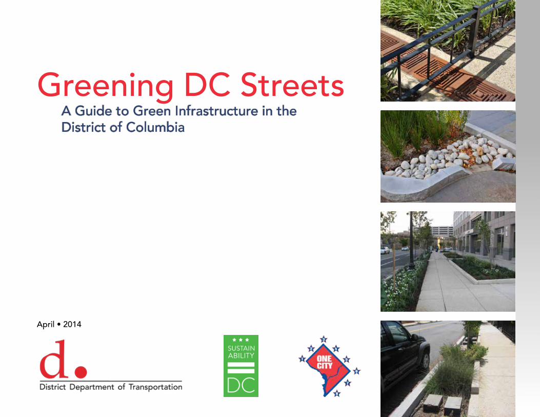
Greening DC StreetsA Guide to Green Infrastructure in theDistrict of Columbia
April • 2014
Dear Neighbor,
Tree-lined streets and wide, open public spaces make the District of Columbia a great and green place to live, work and visit. The L’Enfant Plan—the original urban plan for the District that was developed by Pierre Charles L’Enfant in 1791—included wide city streets lined with trees as part of the capital city’s design. This tradition was expanded in 1870 when the District designated the public space between the sidewalk and property line as green space and included it as part of the city’s park system. To build on this legacy of using streets to define the city’s green and park-like character, the District Department of Transportation (DDOT) presents “Greening DC Streets,” a guide to green infrastructure in the District.
Over time, pavement on streets has contributed to excess stormwater runoff and increased levels of pollutants in the city’s waterways. Green infrastructure reduces stormwater runoff and improves water quality. On city streets, we can install bioretention areas, rain gardens, permeable pavements, landscaping and plant trees to increase the city’s green infrastructure.
Green infrastructure, unlike traditional “gray” infrastructure approaches to stormwater management, provides multiple benefits to communities. Planting more trees and landcaping in public spaces cleans the air, cools the city, provides more habitat for wildlife, adds green maintenance jobs, increases property values and leads to a better, healthier quality of life for District residents and visitors.
The District is striving to be the healthiest, greenest and most livable city in the nation and has established the Sustainable DC Plan to achieve greening goals. The District’s public space is a valuable asset that makes up approximately 26 percent of the city’s land area. By working together with residents and property owners, we intend to install green infrastructure on all streets to support the Sustainable DC Plan.
This guide to “Greening DC Streets” is to be used along with DDOT’s Green Infrastructure Standards for the District’s public right-of-way. These green infrastructure measures, when implemented, will ensure the District remains a green city for many years to come.
Terry BellamyDirector
Bio
rete
ntio
n A
dja
cent
to
Roa
dw
ay •
Con
solid
ated
For
ensi
c La
b, E
Str
eet
SW •
Was
hing
ton,
DC
Table of ConTenTs
ChapTer 1 - InTroduCTIon To Green InfrasTruCTure &low ImpaCT developmenT................................................................ 4
1.1 The naTural and urban envIronmenT
1.2 GreenInG The sTreeTs
1.3 The dC envIronmenT
1.4 dC publIC spaCe
ChapTer 2 - Tools for GreenInG The sTreeT......................................................8 2.1 InTroduCTIon
2.2 Types of permeable pavemenT
2.3 Types of bIoreTenTIon
2.4 Types of Tree spaCe desIGn
ChapTer 3 - Green InfrasTruCTure desIGn examples..........................................20 3.1 InTroduCTIon
3.2 resIdenTIal sTreeT wITh deTaChed houses
3.3 resIdenTIal sTreeT wITh row houses
3.4 CommerCIal sTreeT wITh wIde sIdewalk
3.5 CommerCIal sTreeT wITh narrow sIdewalk
3.6 Green alley
3.7 TraffIC TrIanGle
ChapTer 4 - ImplemenTInG Green InfrasTruCTure In dC.....................................34 4.1 desIGn and ConsTruCTIon
4.2 maInTenanCe
referenCes ....................................................................................................36
Bio
rete
ntio
n •
DD
OE
1st
Str
eet
NE
• W
ashi
ngto
n, D
C
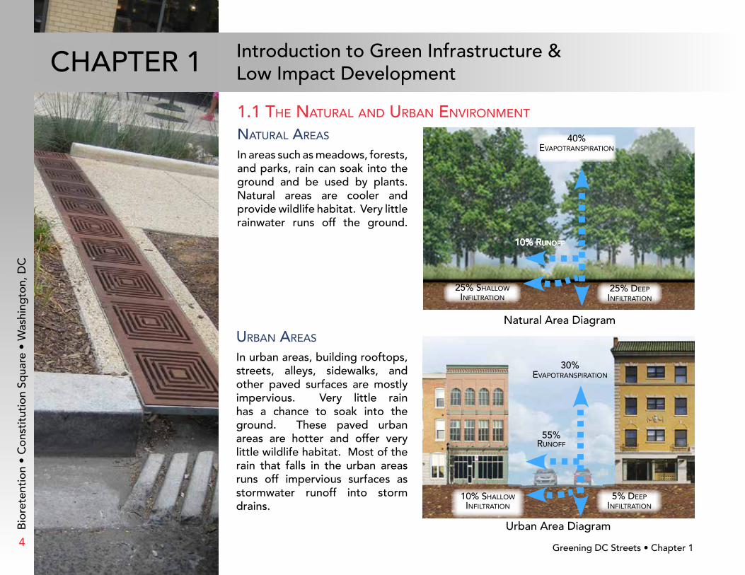
urban areas
In urban areas, building rooftops, streets, alleys, sidewalks, and other paved surfaces are mostly impervious. Very little rain has a chance to soak into the ground. These paved urban areas are hotter and offer very little wildlife habitat. Most of the rain that falls in the urban areas runs off impervious surfaces asstormwater runoff into stormdrains.
1.1 The naTural and urban envIronmenT
naTural areas
In areas such as meadows, forests, and parks, rain can soak into the ground and be used by plants. Natural areas are cooler and provide wildlife habitat. Very little rainwater runs off the ground.
25% shallow InfIlTraTIon
25% deep InfIlTraTIon
40% evapoTranspIraTIon
10% runoff
Bio
rete
ntio
n •
Con
stit
utio
n Sq
uare
• W
ashi
ngto
n, D
C
Natural Area Diagram
Urban Area Diagram
Greening DC Streets • Chapter 14
Introduction to Green Infrastructure &Low Impact DevelopmentChapTer 1
30% evapoTranspIraTIon
55%runoff
5% deepInfIlTraTIon
10% shallow InfIlTraTIon
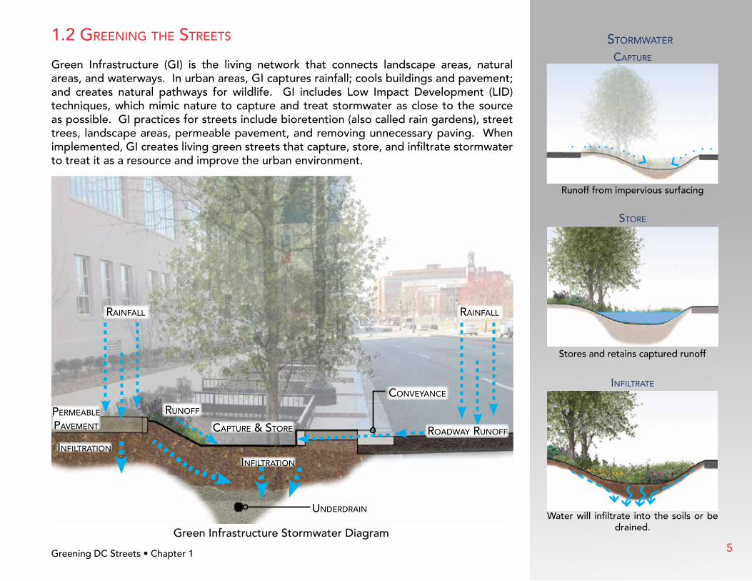
1.2 GreenInG The sTreeTs
Green Infrastructure (GI) is the living network that connects landscape areas, natural areas, and waterways. In urban areas, GI captures rainfall; cools buildings and pavement; and creates natural pathways for wildlife. GI includes Low Impact Development (LID) techniques, which mimic nature to capture and treat stormwater as close to the source as possible. GI practices for streets include bioretention (also called rain gardens), street trees, landscape areas, permeable pavement, and removing unnecessary paving. When implemented, GI creates living green streets that capture, store, and infiltrate stormwater to treat it as a resource and improve the urban environment.
sTormwaTer
CapTure
Runoff from impervious surfacing
InfIlTraTe
Water will infiltrate into the soils or be drained.
sTore
Stores and retains captured runoff
Greening DC Streets • Chapter 1 Green Infrastructure Stormwater Diagram
underdraIn
raInfall raInfall
runoffpermeable pavemenT CapTure & sTore
InfIlTraTIon
InfIlTraTIon
ConveyanCe
roadway runoff
5

The District of Columbia is a unique city made up of both natural and urban areas - 43 percent of the
city is impervious. When rain falls in the District and becomes stormwater runoff, much of it
flows into one of three major water bodies: the Potomac River, the Anacostia River,
or Rock Creek. Stormwater carries the pollutants, trash, and warmer
temperatures it collects from roads and buildings and
delivers them into our rivers and streams. In
the central core of the city, stormwater and
sewage flow into the same pipes,
called the combined s e w e r .
In heavy rainfall, the
pipes cannot carry the extra water
which causes overflow into District waterways.
leGendwaTershed boundarIes
major roads
sTreams
waTer
separaTe sewer area
CombIned sewer area
roCk Creek waTershed
anaCosTIa rIver waTershed
poTomaC rIver waTershed
1.3 The dC envIronmenT
Greening DC Streets • Chapter 1
Bio
rete
ntio
n •
Rho
de
Isla
nd A
venu
e •
Was
hing
ton,
DC
6

1.4 dC publIC spaCe
Stormwater runoff in the District is regulated by the Municipal Separated Storm Sewer Permit (MS-4) issued by the Environmental Protection Agency (EPA) and the Long-Term Control Plan (LTCP) for controlling combined sewer overflows (CSO). In 2013, the District published revisions to the Stormwater Management Regulations as required by the MS-4 permit. The regulations require retention of stormwater volume on site for major construction projects, including the public right-of-way (ROW)
The public ROW comprises 26 percent of the total land area in the District. This land area presents a significant opportunity to reduce runoff and improve the urban environment through green streets. This manual introduces techniques to install green infrastructure in the street, parking lane, tree space, sidewalk, and public parking. This guide and the “Green Infrastructure Design Standards,” supplements to DDOT Standard Drawings, Specifications, and Design Manual should be used for all public and private project designs in the ROW.
Bio
rete
ntio
n •
3rd
& T
ing
ey S
tree
t SE
• W
ashi
ngto
n, D
C
Public Right-of-Way (ROW) Diagram
publIC parkInG
publIC parkInG
sIdewalk sIdewalkTree spaCe
Tree spaCesTreeT
prIvaTe spaCeprIvaTe spaCe publIC rIGhT-of-way
Greening DC Streets • Chapter 1 7

2.1 InTroduCTIon
Green Infrastructure (GI) and Low Impact Development (LID) solutions are designed to be sustainable, attractive, and cost effective. The range of urban opportunities includes rain gardens, natural landscaping, street trees, curb extensions, permeable pavements, and green roofs. These strategies use natural processes to reduce development impacts. This chapter will focus on three areas appropriate for use in the public space.
permeable pavemenT Permeable paving systems provide a hard surface, while allowing water to flow through to the underlying soils instead of into the storm sewer. It is a LID technique in which the space used for the practice can also be used for sidewalks, roads, and parking spaces.
bIoreTenTIon
Bioretention uses the natural functions of plants and soils to remove pollutants from stormwater runoff. The strategy uses storage, sediment capture, and biological processes to clean the water. These mimic processes that occur in nature before water reaches waterways.
Tree spaCe
Trees are a powerful green infrastructure tool due to their ability to capture water on leaves, direct it to the ground on stems, absorb it through root systems, and transpire it as water vapor directly back into the atmosphere.
Common desIGn Issues
Design challenges that are considered in all green infrastructure projects include soil infiltration, planting design, pedestrian safety, existing slope, and utilities. These issues are highlighted on the following pages.
Greening DC Streets • Chapter 2
Bior
eten
tion
Adja
cent
to R
oadw
ay •
The
Yar
ds S
E W
ater
fron
t • W
ashi
ngto
n, D
C
8
Tools for Greening the StreetChapTer 2

2.2 Types of permeable pavemenT
whaT Is permeable pavemenT?Permeable pavement is an engineered top layer and base layer that allows water to move though it. The goal is to take rainwater as it falls and quickly move it to the lower layers of the system. Stormwater is stored in an underlying stone layer until it infiltrates into the soil below, aiding in groundwater recharge, or releases slowly to the storm sewer system. Pollutants are filtered through the pavement and base layers.
Greening DC Streets • Chapter 2
Perm
eab
le U
nit
Pave
rs •
Geo
rgia
Ave
Str
eets
cap
e •
Was
hing
ton,
DC
porous asphalT Porous asphalt is very similar to traditional asphalt except the sand or “fines” are reduced from the mix so water can move through the pavement.
pervIous ConCreTe
Sands and “fines” are reduced in the concrete mix to allow water to flow through the pavement into a stone bed and eventually the ground. It maintains the durability of standard concrete.
permeable unIT pavers
Unlike traditional pavers, there are gaps between each paver to allow water to flow between the pavers and into the base layer.
porous rubber
Made from recycled rubber and small stones, porous rubber works like pervious concrete, but can be installed over tree roots.
9
Greening DC Streets • Chapter 2
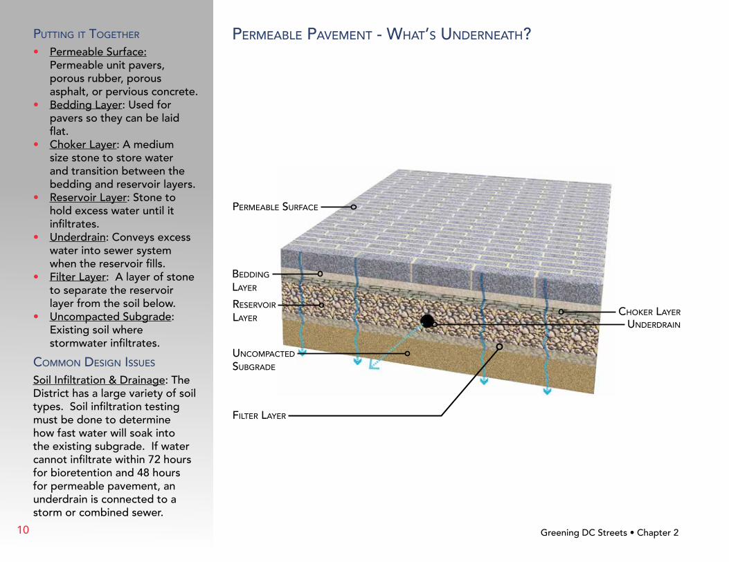
permeable pavemenT - whaT’s underneaTh?puTTInG IT ToGeTher
• Permeable Surface: Permeable unit pavers, porous rubber, porous asphalt, or pervious concrete.
• Bedding Layer: Used for pavers so they can be laid flat.
• Choker Layer: A medium size stone to store water and transition between the bedding and reservoir layers.
• Reservoir Layer: Stone to hold excess water until it infiltrates.
• Underdrain: Conveys excess water into sewer system when the reservoir fills.
• Filter Layer: A layer of stone to separate the reservoir layer from the soil below.
• Uncompacted Subgrade: Existing soil where stormwater infiltrates.
Common desIGn Issues
Soil Infiltration & Drainage: The District has a large variety of soil types. Soil infiltration testing must be done to determine how fast water will soak into the existing subgrade. If water cannot infiltrate within 72 hours for bioretention and 48 hours for permeable pavement, an underdrain is connected to a storm or combined sewer.
permeable surfaCe
beddInG layer
reservoIr layer
underdraIn
fIlTer layer
Choker layer
unCompaCTed subGrade
10

2.3 Types of bIoreTenTIon
whaT Is bIoreTenTIon?Bioretention is a landscape system that filters pollutants and sediment from runoff. The layers of plant material, mulch, planting media (a mix of soil, sand, and compost), and stone capture metals, nutrients, and bacteria that flow into the surrounding rivers. The rainwater is held in the planting bed until it infiltrates into the ground or evaporates. The entire system can fit into small spaces, making it adaptable to curb extensions, tree spaces along the road, medians, terraced slopes, and planter boxes.
Curb exTensIon Runoff follows the existing curb line and enters the LID facility directly. Excess runoff flows through the system to an outlet or overflow drain into another facility downstream.
bIoswale
Runoff flows directly into a bioswale which is located adjacent to the street. A bioswale will follow the slope of the street and may have check dams to make the grade step down.
bIoreTenTIon In open area
Runoff drains into the bioretention planting from the surrounding area (sidewalks, roadways, or grass). The size and shape can fit the available space.
bIoreTenTIon planTer adjaCenT To roadway
Runoff follows the existing curb line and enters the LID facility through curb cuts. Excess runoff exits through the same curb cuts or into drains located in the planting area.
Greening DC Streets • Chapter 2
Bior
eten
tion
Plan
ter A
djac
ent t
o Ro
adw
ay •
Cas
ey T
rees
Hea
dqua
rter
s 12t
h St
reet
NE
• W
ashi
ngto
n, D
C
11

sTreeT & bIke lanebIoreTenTIon &
Tree spaCesIdewalk
Greening DC Streets • Chapter 2
bIoreTenTIon planTer adjaCenT To roadway
whaT’s underneaTh?see paGe 16 for more InformaTIon
planTs
where To use?• Street with no adjacent
on-street parking.• Where street trees are
needed.• Street where bike lane is
adjacent to curb.
lImITaTIons
• Not for on-street parking areas.
Common desIGn Issues
Planting Design: Bioretention adds a landscape amenity to the streetscape. Trees, shrubs, grasses, and perennials are used to create a diverse landscape suitable for the site conditions and neighborhood. Plants should be chosen based on the level of care expected at the facility. Planting design must be done to ensure sight lines are preserved for pedestrians and vehicles on the street.
See DDOT Green Infrastructure Plant List for suitable plant species to use in bioretention areas.
waTer flows InTo The bIoreTenTIon ThrouGh Curb CuTs
12
sTreeT parkInG
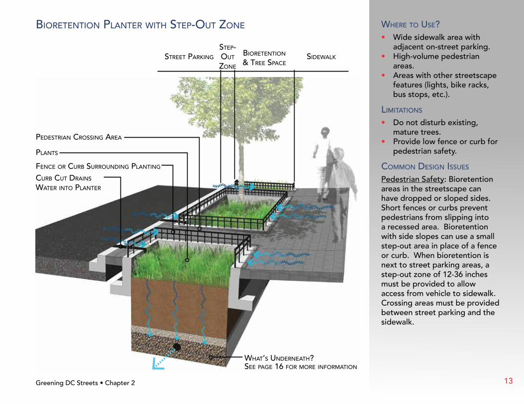
sTep-ouT Zone
bIoreTenTIon & Tree spaCe
sIdewalk
Greening DC Streets • Chapter 2
bIoreTenTIon planTer wITh sTep-ouT Zone where To use?• Wide sidewalk area with
adjacent on-street parking.• High-volume pedestrian
areas.• Areas with other streetscape
features (lights, bike racks, bus stops, etc.).
lImITaTIons
• Do not disturb existing, mature trees.
• Provide low fence or curb for pedestrian safety.
Common desIGn Issues
Pedestrian Safety: Bioretention areas in the streetscape can have dropped or sloped sides. Short fences or curbs prevent pedestrians from slipping into a recessed area. Bioretention with side slopes can use a small step-out area in place of a fence or curb. When bioretention is next to street parking areas, a step-out zone of 12-36 inches must be provided to allow access from vehicle to sidewalk. Crossing areas must be provided between street parking and the sidewalk.
Curb CuT draIns waTer InTo planTer
fenCe or Curb surroundInG planTInG
pedesTrIan CrossInG area
planTs
whaT’s underneaTh?see paGe 16 for more InformaTIon
13
sTreeTbIoreTenTIon & Tree spaCe
Curb exTensIon sIdewalk
Greening DC Streets • Chapter 2
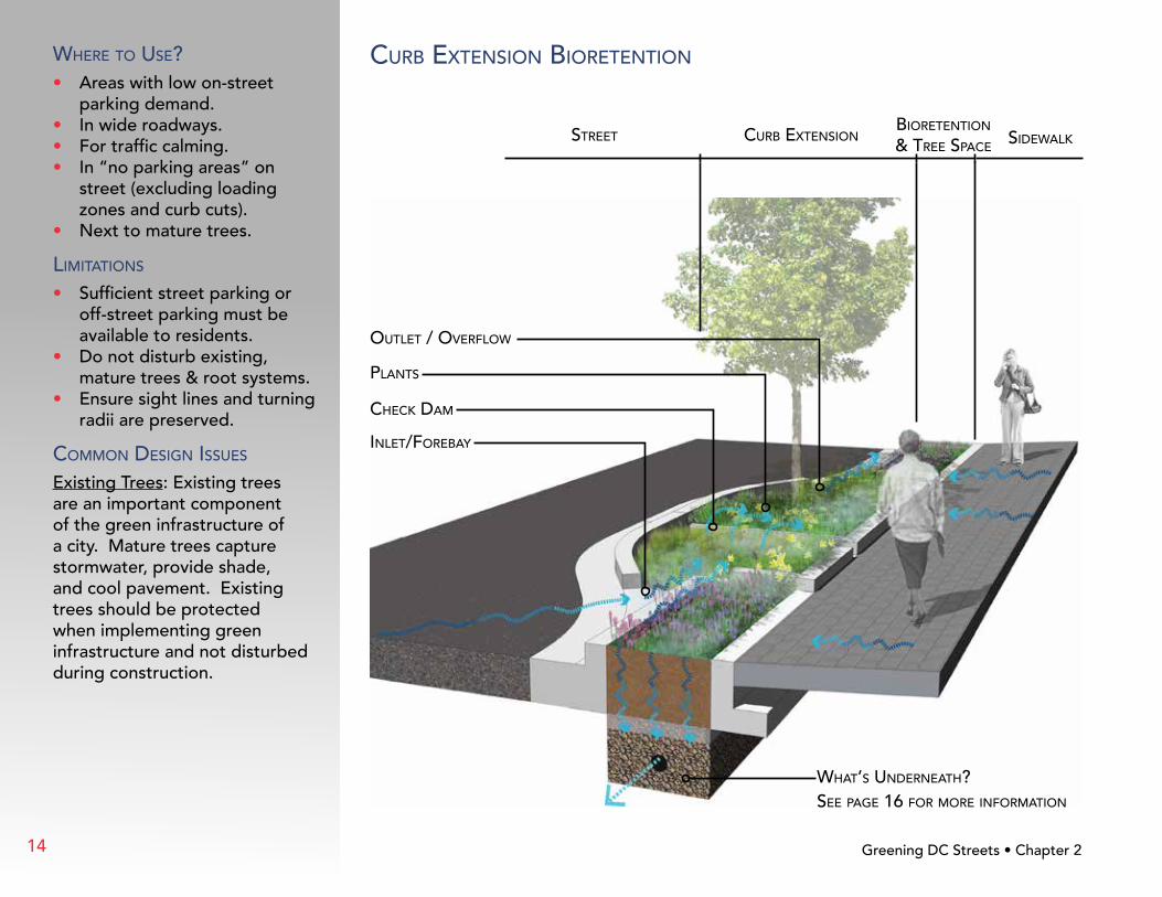
Curb exTensIon bIoreTenTIonwhere To use?• Areas with low on-street
parking demand.• In wide roadways.• For traffic calming.• In “no parking areas” on
street (excluding loading zones and curb cuts).
• Next to mature trees.
lImITaTIons
• Sufficient street parking or off-street parking must be available to residents.
• Do not disturb existing, mature trees & root systems.
• Ensure sight lines and turning radii are preserved.
Common desIGn Issues
Existing Trees: Existing trees are an important component of the green infrastructure of a city. Mature trees capture stormwater, provide shade, and cool pavement. Existing trees should be protected when implementing green infrastructure and not disturbed during construction.
planTs
ouTleT / overflow
CheCk dam
InleT/forebay
whaT’s underneaTh?see paGe 16 for more InformaTIon
14
sTreeT bIoswale sIdewalk
CheCk dam
planTed boTTom
sod or Gravel sTrIp
planTed sIdes
whaT’s underneaTh?see paGe 16 for more InformaTIon
Greening DC Streets • Chapter 2
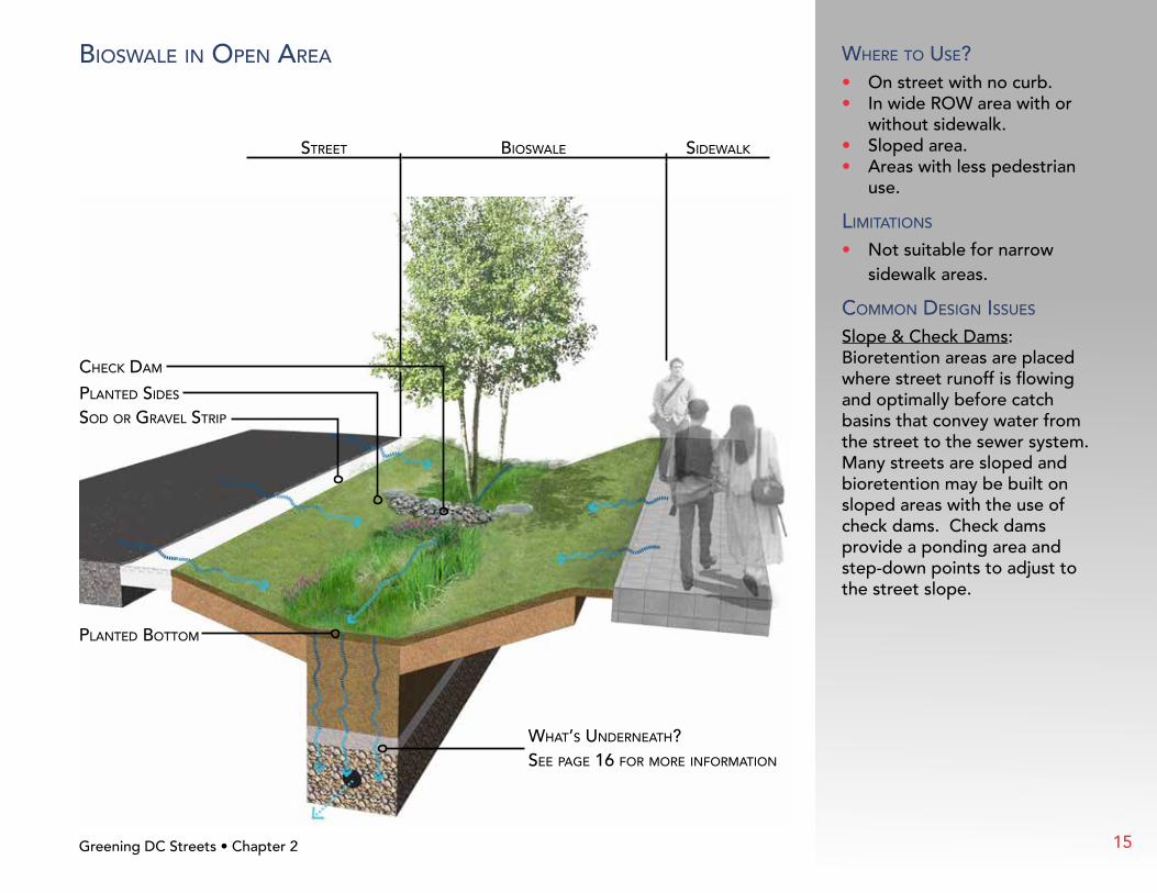
bIoswale In open area where To use?• On street with no curb.• In wide ROW area with or
without sidewalk.• Sloped area.• Areas with less pedestrian
use.
lImITaTIons
• Not suitable for narrow sidewalk areas.
Common desIGn Issues
Slope & Check Dams: Bioretention areas are placed where street runoff is flowing and optimally before catch basins that convey water from the street to the sewer system. Many streets are sloped and bioretention may be built on sloped areas with the use of check dams. Check dams provide a ponding area and step-down points to adjust to the street slope.
15
sTreeT bIoreTenTIon & Tree spaCe sIdewalk
Greening DC Streets • Chapter 2
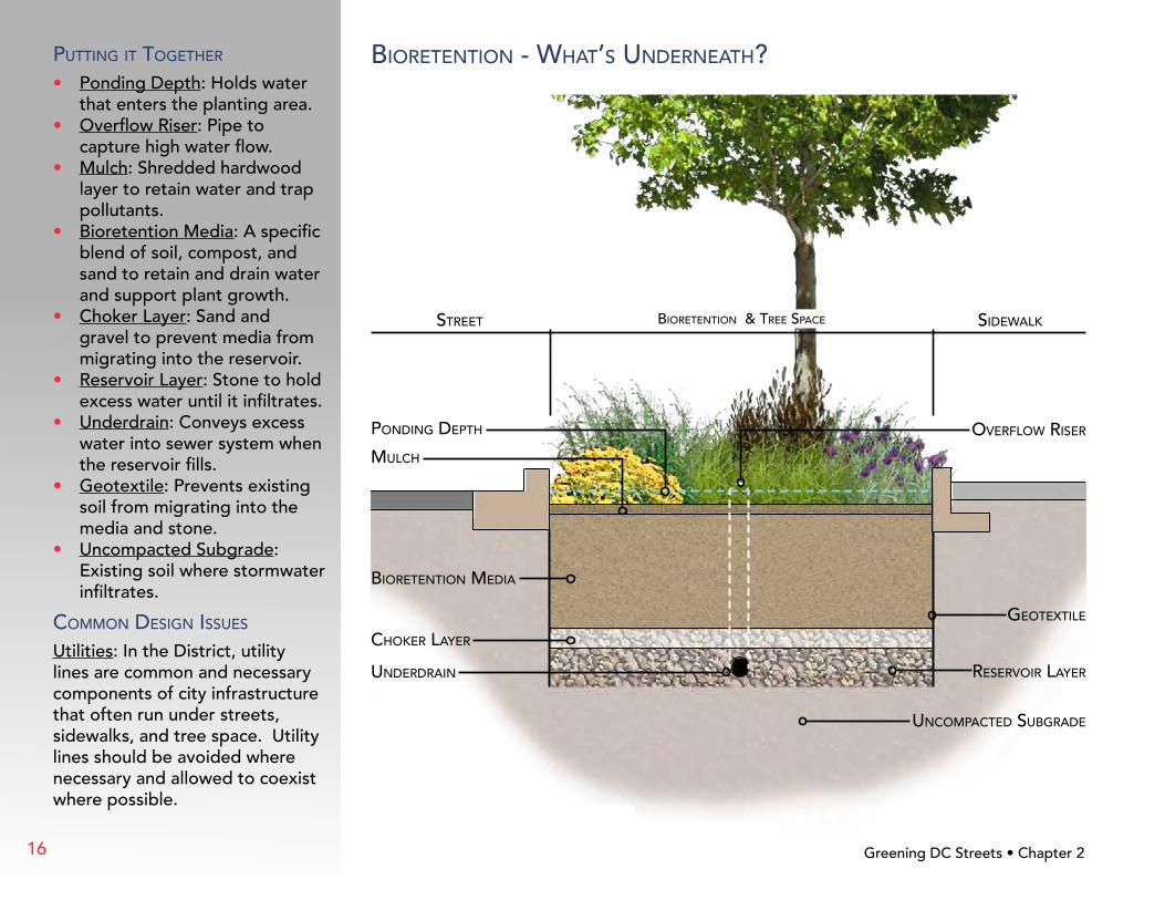
bIoreTenTIon - whaT’s underneaTh?puTTInG IT ToGeTher
• Ponding Depth: Holds water that enters the planting area.
• Overflow Riser: Pipe to capture high water flow.
• Mulch: Shredded hardwood layer to retain water and trap pollutants.
• Bioretention Media: A specific blend of soil, compost, and sand to retain and drain water and support plant growth.
• Choker Layer: Sand and gravel to prevent media from migrating into the reservoir.
• Reservoir Layer: Stone to hold excess water until it infiltrates.
• Underdrain: Conveys excess water into sewer system when the reservoir fills.
• Geotextile: Prevents existing soil from migrating into the media and stone.
• Uncompacted Subgrade: Existing soil where stormwater infiltrates.
Common desIGn Issues
Utilities: In the District, utility lines are common and necessary components of city infrastructure that often run under streets, sidewalks, and tree space. Utility lines should be avoided where necessary and allowed to coexist where possible.
pondInG depTh
mulCh
overflow rIser
underdraIn
GeoTexTIle
bIoreTenTIon medIa
Choker layer
reservoIr layer
unCompaCTed subGrade
16

2.4 Types of Tree spaCe desIGn
why are Trees ImporTanT?Trees make a streetscape feel welcoming, help manage stormwater, and reduce the urban heat island effect by providing shade. Trees have the ability to capture rain on leaves, direct it to the ground on stems, absorb it through root systems, and transpire it as water vapor directly back into the atmosphere.
Trees in the typical urban environment are confined to small planting areas where they struggle to reach a mature size or live a long life. Through the use of Structural Soil, Structural Cell, or Suspended Sidewalk techniques, soil volumes and space for tree roots to grow uninhibited can be greatly increased. These techniques also allow for more water and air to reach the tree roots.
sTruCTural soIls
A specific mix of stone and soil that supports the sidewalk while allowing tree roots to grow normally.
sTruCTural Cells
Manufactured cells support the sidewalk allowing uncompacted soil to promote tree roots to grow below.
suspended sIdewalk
Thickened sidewalk with reinforcement and/or footings can be used allowing tree roots to grow below the sidewalk. Tr
ee S
pac
e D
esig
n •
K S
tree
t N
W •
Was
hing
ton,
DC
Greening DC Streets • Chapter 2 17

Greening DC Streets • Chapter 2
plan vIew
plan vIew
plan vIew
seCTIon vIew
seCTIon vIew
seCTIon vIew
medIum Tree
volume requIremenTs:1,000 CubIC feeT
larGe Tree
volume requIremenTs:1,500 CubIC feeT
small Tree
volume requIremenTs:600 CubIC feeT
soIl volume sIZInG
• Adequate soil space provides the nutrients, water, air, and root space that trees need to have a long, successful life.
• The soil volume required depends on the fully-grown tree size (generally two cubic feet of soil per one square foot of the tree’s mature drip line area).
• Soil for trees should be three-feet deep; the length and width must ensure the appropriate volume for the tree species and size.
oTher ConsIderaTIons
• Provide as much open space as possible for the tree to allow the tree to grow and access water.
• Providing structural soils, suspended sidewalks, or structural slabs to edges of paved areas encourages tree roots to extend further and into adjacent green areas (lawns, planting beds, etc.).
soIl volume In planTInG
sTrIp
sIdewalk
soIl volume parTIally under walk
sIdewalk
soIl volume mosTly under walk
sIdewalk
18
sTreeTTree spaCe &
permeable pavemenTsIdewalk
permeable pavemenT or Impermeable pavemenT wITh sloT draIn (noT shown)
soIl (per applICaTIon)
planTInG soIl
mulCh
permeable pavemenT
sand
unCompaCTed subGrade
Tree spaCe desIGn - whaT’s underneaTh?
Greening DC Streets • Chapter 2
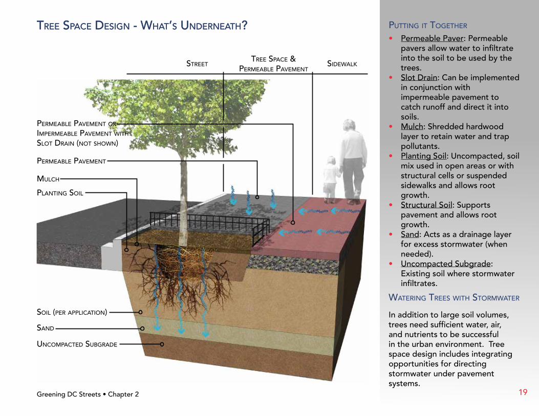
puTTInG IT ToGeTher
• Permeable Paver: Permeable pavers allow water to infiltrate into the soil to be used by the trees.
• Slot Drain: Can be implemented in conjunction with impermeable pavement to catch runoff and direct it into soils.
• Mulch: Shredded hardwood layer to retain water and trap pollutants.
• Planting Soil: Uncompacted, soil mix used in open areas or with structural cells or suspended sidewalks and allows root growth.
• Structural Soil: Supports pavement and allows root growth.
• Sand: Acts as a drainage layer for excess stormwater (when needed).
• Uncompacted Subgrade: Existing soil where stormwater infiltrates.
waTerInG Trees wITh sTormwaTer
In addition to large soil volumes, trees need sufficient water, air, and nutrients to be successful in the urban environment. Tree space design includes integrating opportunities for directing stormwater under pavement systems.
Tree spaCe desIGn - whaT’s underneaTh?
19

3.1 InTroduCTIon
Implementing Green Infrastructure (GI) and Low Impact Development (LID) within the public space requires a number of considerations to create an amenity that is attractive while treating stormwater from the surrounding streets and sidewalks.
Bio
rete
ntio
n •
Con
stit
utio
n Sq
uare
• W
ashi
ngto
n, D
C
Greening DC Streets • Chapter 320
Green Infrastructure Design ExamplesChapTer 3

Public agencies, businesses, residences, utilities, and pedestrians use the space between the curb and buildings (both above and below the ground) for numerous activities and needs. Common limitations including existing trees, utilities, poor infiltration, street parking, slope, etc. for all sites need to be analyzed to determine if it is a design constraint. Since each street is unique, there are different opportunities and limitations for installing permeable pavement, bioretention, and tree space design.
This section examines different types of streetscapes in the District and appropriate GI and LID practices. Suggested solutions illustrate how various techniques fit into each streetscape.
Bio
rete
ntio
n Pl
anti
ng •
Neb
rask
a A
ve N
W •
Was
hing
ton,
DC
Greening DC Streets • Chapter 3
Bioretention • NPR Building, L Street NE • Washington, DC
21

3.2 resIdenTIal sTreeT wITh deTaChed houses
exIsTInG
Greening DC Streets • Chapter 3
lawn sTrIp
sTreeT parkInG
sTreeT Tree
sIdewalk
opporTunITIes
• Space in parking lane.
• Available off-street parking.
• Adding street trees.
• Street narrowing.
• Catch basin location.
• Overhead utilities (reduce below ground conflicts).
lImITaTIons
• Residential driveways.
• Do not block street parking.
• Maintain sufficient parking for residents.
• Avoid subsurface utilities or ensure offsets can be met.
• Existing, mature trees.
• Location of storm sewer for underdrain connection.
planTInG desIGn
• Low to medium level of care.
22

3.2 resIdenTIal sTreeT wITh deTaChed houses
wITh Green InfrasTruCTure
Law
n St
rip
Bio
rete
ntio
n
Driveway
Stre
etO
n-St
reet
Pa
rkin
g
Sid
ewal
k
Greening DC Streets • Chapter 3
Curb exTensIons Curb extensions are appropriate solutions in neighborhoods where available on-street parking meets or exceeds needs. Curb extensions enhance the streetscape, can be built around existing trees, and can provide traffic calming.
Curb exTensIon
bIoreTenTIon planTInG
new sTreeT Tree
ouTleT
InleT
23
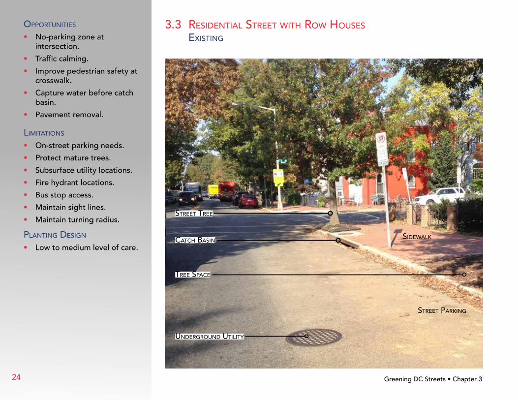
3.3 resIdenTIal sTreeT wITh row houses
exIsTInG
Greening DC Streets • Chapter 3
sIdewalk
sTreeT parkInG
underGround uTIlITy
CaTCh basIn
sTreeT Tree
Tree spaCe
opporTunITIes
• No-parking zone at intersection.
• Traffic calming.
• Improve pedestrian safety at crosswalk.
• Capture water before catch basin.
• Pavement removal.
lImITaTIons
• On-street parking needs.
• Protect mature trees.
• Subsurface utility locations.
• Fire hydrant locations.
• Bus stop access.
• Maintain sight lines.
• Maintain turning radius.
planTInG desIGn
• Low to medium level of care.
24

Bio
rete
ntio
n
Bui
ldin
g o
r R
esid
ence
Stre
et
Sid
ewal
kPa
vem
ent
Rem
oval
Perm
eab
le P
aver
s
Exi
stin
g T
rees
3.3 resIdenTIal sTreeT wITh row houses
wITh Green InfrasTruCTure
Curb exTensIons & permeable pavemenT
In neighborhoods with high demand for street parking, curb extensions can be placed in the no parking zone at intersections to reduce street parking loss. Permeable paving in the sidewalks and parking lanes can capture stormwater from the street while maintaining street parking.
Greening DC Streets • Chapter 3
InleT
exIsTInG Curb remaIns
Curb exTensIon
CaTCh basIn
pavemenT removal
exIsTInG sTreeT Tree
bIoreTenTIon planTInG
exIsTInG “no parkInG” sIGn
on-sTreeT parkInG
preserved
25

3.4 CommerCIal sTreeT wITh wIde sIdewalk
exIsTInG
Greening DC Streets • Chapter 3
sIdewalk
sTreeT parkInG
sTreeT lIGhT
sTreeT Tree
opporTunITIes
• Wide sidewalks can be narrowed.
• Remove pavement in front of building.
• Use street tree area to capture stormwater.
• Provide tree soil volume under pavement.
• Property owner or business improvement district may maintain landscaping
• Streetscape fixtures can be surrounded by permeable pavement.
lImITaTIons
• Subsurface utility locations.
• Street parking (provide step-out zone and pedestrian crossing).
• Streetscape fixture placement (streetlights, meters, trash cans, bike racks, bus stops, etc.).
• Building entrances.
• Sidewalk cafés.
• Safety barrier.
planTInG desIGn
• Medium to high level of care.
26

Bio
rete
ntio
n
Gre
enin
g t
he P
ublic
Sp
ace
Bui
ldin
g
Stre
et
Sid
ewal
k
Pave
rs
3.4 CommerCIal sTreeT wITh wIde sIdewalk
wITh Green InfrasTruCTure
bIoreTenTIon wITh sTep-ouT Zone & TrenCh draIns In commercial areas with wide sidewalks, integrating tree space design with LID enhances the streetscape while treating stormwater. Notice the design maintains on-street parking while removing impervious surfaces from the streetscape.
Greening DC Streets • Chapter 3
permeable pavemenT In pedesTrIan CrossInG
Curb CuT wITh meTal TrenCh draIn Cover
bIoreTenTIon planTInG
Curb
sTep ouT Zone
GreenInG The publIC spaCe
27
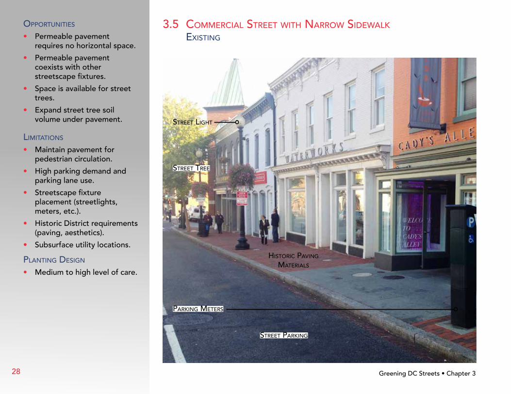
3.5 CommerCIal sTreeT wITh narrow sIdewalk
exIsTInG opporTunITIes
• Permeable pavement requires no horizontal space.
• Permeable pavement coexists with other streetscape fixtures.
• Space is available for street trees.
• Expand street tree soil volume under pavement.
lImITaTIons
• Maintain pavement for pedestrian circulation.
• High parking demand and parking lane use.
• Streetscape fixture placement (streetlights, meters, etc.).
• Historic District requirements (paving, aesthetics).
• Subsurface utility locations.
planTInG desIGn
• Medium to high level of care.
Greening DC Streets • Chapter 3
hIsTorIC pavInG maTerIals
parkInG meTers
sTreeT parkInG
sTreeT lIGhT
sTreeT Tree
28

Perm
eab
le P
avin
g
Stre
et
Sid
ewal
k
Soil
Volu
me
Und
er P
avem
ent
3.5 CommerCIal sTreeT wITh narrow sIdewalk
wITh Green InfrasTruCTure
Tree spaCe desIGn & permeable pavemenT
In urban and commercial areas with narrow sidewalks, a mixture of LID techniques, including permeable pavement and tree space design can be used to maintain pedestrian circulation and on-street parking.
Bui
ldin
gGreening DC Streets • Chapter 3
permeable pavemenT
porous rubber aT Tree
expanded soIl volume under pavemenT
permeable pavemenT
29

3.6 alley
exIsTInG
opporTunITIes
• Infrastructure improvement.
• Reduce runoff from paved alleys.
• Provide connections for cars, bikes, and pedestrians.
• Create access to buildings and residences.
• Mitigate drainage problems.
• Soil infiltration.
lImITaTIons
• Protect building foundations from water infiltration.
• Location of storm sewer for underdrain connection.
• Subsurface utility locations.
• Historic District requirements (paving, aesthetics).
Greening DC Streets • Chapter 3
CompaCTed Gravel road or oTher
ImpervIous surfaCe
properTy aCCess
30
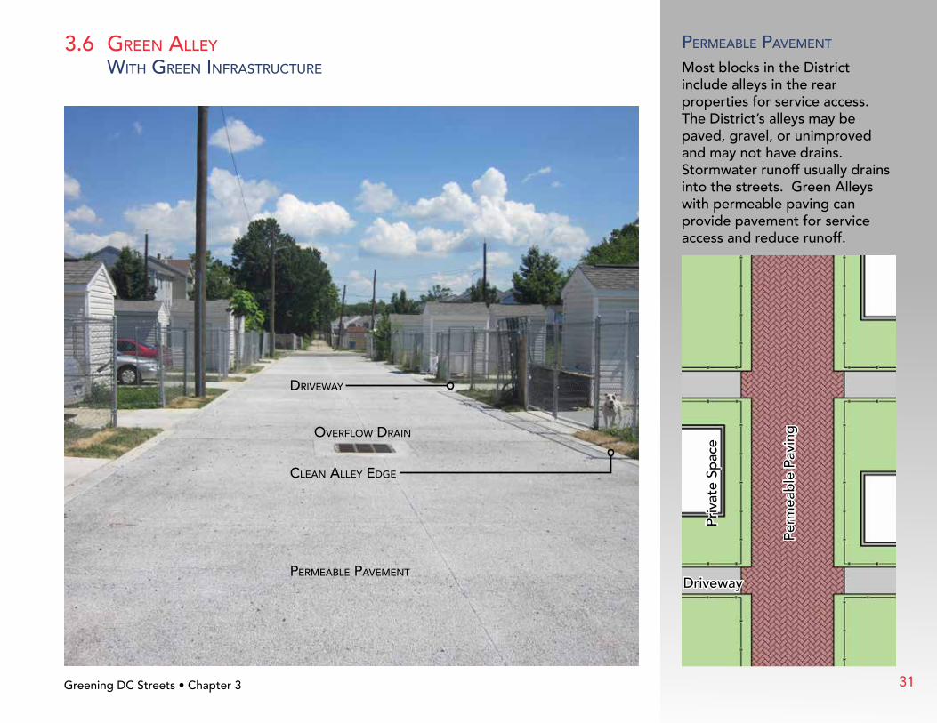
3.6 Green alley
wITh Green InfrasTruCTure
permeable pavemenT
Most blocks in the District include alleys in the rear properties for service access. The District’s alleys may be paved, gravel, or unimproved and may not have drains. Stormwater runoff usually drains into the streets. Green Alleys with permeable paving can provide pavement for service access and reduce runoff.
Driveway
Perm
eab
le P
avin
g
Priv
ate
Spac
e
overflow draIn
drIveway
Clean alley edGe
Greening DC Streets • Chapter 3
permeable pavemenT
31
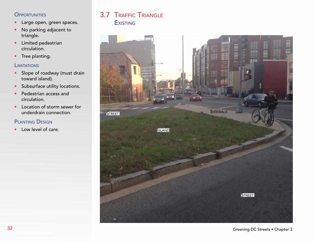
3.7 TraffIC TrIanGle
exIsTInG
opporTunITIes
• Large open, green spaces.
• No parking adjacent to triangle.
• Limited pedestrian circulation.
• Tree planting.
lImITaTIons
• Slope of roadway (must drain toward island).
• Subsurface utility locations.
• Pedestrian access and circulation.
• Location of storm sewer for underdrain connection.
planTInG desIGn
• Low level of care.
Greening DC Streets • Chapter 3
sIdewalk
Island
sTreeT
sTreeT
32

3.7 TraffIC TrIanGle
wITh Green InfrasTruCTure
bIoreTenTIon In open area
The District’s grid layout with diagonal streets creates small open spaces such as traffic triangles that are optimal for implementing Green Infrastructure (GI). Many streets include medians which separate lanes of traffic where GI can be added.
Sidewalk
Street
Stre
etB
iore
tent
ion
in O
pen
Are
a
Greening DC Streets • Chapter 3
Curb CuT InleT
bIoreTenTIon planTInG
new Tree
bIoreTenTIon In open area
33
4.1 desIGn and ConsTruCTIon
The “Sustainable DC Plan,” adopted in 2013, sets long-range goals for making the District the greenest city in the nation. The plan calls for increasing green infrastructure in the public right-of-way (ROW) and taking actions to improve the health of the city’s waterways.
District Stormwater regulations require stormwater volume retention on all major construction projects. Both public and private projects constructing in the ROW are required to retain stormwater to the maximum extent practicable. Designers must examine all uses of public space and place stormwater management where space and use allows.
DDOT is installing Green Infrastructure (GI) as part of regulated construction projects and retrofit projects to reduce stormwater runoff in more areas of the city. Green Street and Green Alley projects utilize GI techniques and may be constructed where watershed and infrastructure improvements are prioritized. DC Water is including GI as part of the Long Term Control Plan to control stormwater runoff in the combined sewer overflow area and reduce overflows.
Greening DC Streets • Chapter 434
Implementing Green Infrastructure in DCChapTer 4

4.2 maInTenanCe
Implementing Green Infrastructure (GI) and Low Impact Development (LID) practices requires maintenance to keep them attractive and functioning. Maintenance levels of care should be considered during the design phase and plants selected from DDOT’s GI plant list according to the following levels:
• Low level of care: Annual maintenance; no irrigation
• Medium level of care: Quarterly maintenance; some water available
• High level of care: Monthly maintenance; site is potentially irrigated
DDOT is responsible for maintaining publicly-installed GI and LID facilities. Private installations must have a maintenance covenant from the owner. Residents can help with GI/LID maintenance by removing trash and weeds, and watering sites during dry periods.
Type of Maintenance Bioretention Permeable Pavement Tree Space
Inspect after storms • •Remove trash/sediment/leaves • • •Clean inlets/outlets •Adjust mulch and/or stone •Water for establishment • •Weed/remove invasive species • •Prune (as needed) • •Replace mulch (3” depth) • •Street sweeper/vacuum (annually) •
Greening DC Streets • Chapter 4 35
referenCesDDOT – Green Infrastructure Standards, (2014), includes the following:
• Supplement to DDOT Design & Engineering Manual
• Supplement to DDOT Standard Drawings
• Supplement to DDOT Standard Specifications for Highways and Structures
• Green Infrastructure Plant List
• Green Infrastructure Maintenance Schedule
ddot.dc.gov/GreenInfrastructure
DDOT – Public Realm Design Manual, (2011)
ddot.dc.gov/PublicRealmDesignManual
DDOT – LID Action Plan, (2010)
ddot.dc.gov/GreenInfrastructure
DDOT – Sustainability Plan, (2010)
ddot.dc.gov/SustainabilityPlan
DDOT – Urban Forestry Administration
ddot.dc.gov/page/DDOT-Urban-Forestry
DDOE –Stormwater Management Rule and Guidebook, (July 19, 2013)
ddoe.dc.gov/swregs
DDOE – Green Area Ratio
ddoe.dc.gov/GAR
Sustainable DC Plan
sustainable.dc.gov/FinalPlan
Casey Trees – Tree Space Design
caseytrees.org/resources/publications/treespacedesign
District of Columbia Tree Canopy Plan
ddoe.dc.gov/sites/default/files/dc/sites/ddoe/page_content/attachments/Draft_Urban_Tree_Canopy_Plan_Final.pdf
Greening DC Streets • Chapter 4
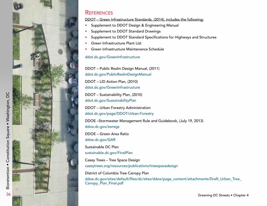
Bio
rete
ntio
n •
Con
stit
utio
n Sq
uare
• W
ashi
ngto
n, D
C
36


55 M Street, SE, Suite 400Washington, DC 20003Phone: (202) 673-6813
ddot.dc.gov


