
Grade
33© 2011 by Dallas Area Rapid Transit. All rights reserved. Grade 3: Communities
objectiveS
• Learn the basics of map reading
• Follow a bus route and identify features on a map
• Understand relative distances on a map
aCtIVIty DashbOarD Perfect for Substitute teachers
PowerPoint
Handouts
interactive — dVd or web
Learning reinforcement
Learning extension
*PowerPoint can be found on enclosed dVd.
aCtIVIty 2.1follow that Dart bus!
essentIaL QUestIOns
what do maps tell us?
DetaILs tyPe Whole-group
time 20 minutes plus 20 minutes homework (40 minutes total)
PriNteD materialS Handouts (Reading A Map, Follow that
DART Bus! map and Follow that DART Bus! questions)
techNology Reading A Map PowerPoint (Activity 2.1); SMART Board or computer projector with online access*
PreParatioN Copy handouts
stanDarDs & skILLstexaS eSSeNtial kNowleDge & SkillS (tekS)
• Geography: Understands location, distance and direction on maps and globes [113.14 SS (b) (5) B-D]
• Reading and comprehension skills [110.14 F]
life SkillS
• Map reading skills
• Familiarity of downtown Dallas landmarks
why are maps useful?

34© 2011 by Dallas Area Rapid Transit. All rights reserved. Grade 3: Communities
Grade
DiScuSSioN PoiNtS aND more
• Go to www.maps.google.com, and type in the address of your school.
• Click on the “Map” and “Satellite” buttons to experiment with the different map-types. Zoom in and zoom out with the + and – buttons.
• Discuss “Essential Questions.”
• Review the Reading A Map PowerPoint (Activity 2.1) or review handout (Reading A
Map).
• Explain to students they will be reading a bus route map and answering questions about the map.
teacher DirectioNS
1. Distribute and review handout (Follow that DART Bus! map).
2. Have students locate the compass and various symbols on the map.
3. Demonstrate how to find each of the cardinal directions.
4. Review the bus route on the map. Discuss the landmarks the bus passes on the route.
5. Have students complete the handout (Follow that DART Bus! questions), either in class or as homework.
35© 2011 by Dallas Area Rapid Transit. All rights reserved. Grade 3: Communities
Grade
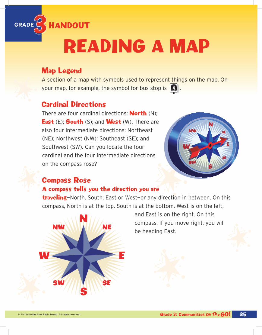
reaDInG a MaPMap Legend A section of a map with symbols used to represent things on the map. On
your map, for example, the symbol for bus stop is .
Cardinal Directions
There are four cardinal directions: north (N);
east (E); south (S); and west (W). There are
also four intermediate directions: Northeast
This scale is for this map only and does not represent true distance.Map is representational and not intended to be an actual map of Dallas.
Dallas City Hall Plaza
MagnoliaBuilding
Bank of America
Plaza
Bank of America
Plaza
2
3
4
1
FoundersSquare
DARTBus
LegendBus RouteBus StopDART Light RailDART Light Rail Station
3
Follow That DART Bus!
(NE); Northwest (NW); Southeast (SE); and
Southwest (SW). Can you locate the four
cardinal and the four intermediate directions
on the compass rose?
Compass rose
a compass tells you the direction you are traveling—North, South, East or West—or any direction in between. On this
compass, North is at the top. South is at the bottom. West is on the left,
and East is on the right. On this
compass, if you move right, you will
be heading East.
hanDOUt

36© 2011 by Dallas Area Rapid Transit. All rights reserved. Grade 3: Communities
Grade
Map scale
People often use a map to find out how far it is from one place to another.
Since a map represents an area much larger than the sheet of paper it is
printed on, a map scale is provided so distances between places can be
measured. This is a map scale — a line that represents a certain distance
on the map. The map scale shows how to measure miles on the map.
Map scale Questions
Use a ruler and the map scale above to calculate how many miles each of
the following lines represent:
_____ miles
_____ mile
_____ mile
_____ miles
0 mi 1 mi 2 mi 3 mi One inch equals one mile
hanDOUt

37© 2011 by Dallas Area Rapid Transit. All rights reserved. Grade 3: Communities
Grade
Map scale Questions
Use a ruler and the map scale above to calculate how many miles each of
the following lines represent:
2 miles
1 mile
1/2 mile
3 1/2 miles
answer key
reaDInG a MaP
answers

38© 2011 by Dallas Area Rapid Transit. All rights reserved. Grade 3: Communities
This
sca
le is
for
thi
s m
ap o
nly
and
does
not
rep
rese
nt t
rue
dist
ance
.M
ap is
rep
rese
ntat
iona
l and
not
inte
nded
to
be a
n ac
tual
map
of
Dal
las.
Dal
las
Cit
y H
all P
laza
Mag
noli
aB
uild
ing
Ban
k o
f A
mer
ica
Pla
za
Ban
k o
f A
mer
ica
Pla
za
2
3
4
1
Foun
ders
Squ
are
DAR
TB
us
Lege
ndBu
s Ro
ute
Bus
Stop
DART
Lig
ht R
ail
DART
Lig
ht R
ail S
tatio
n
3
Follo
w T
hat
DAR
T B
us!

39© 2011 by Dallas Area Rapid Transit. All rights reserved. Grade 3: Communities
Grade fOLLOw that
Dart bUs!name:________________________________________________________________________
1. On ElM STREET, how many miles would you walk from the DART lIGHT RAIl
TRAIN STATION to the MAGNOlIA BUIlDING?
____________________________________________________________________________
2. Going south on GRIFFIN STREET, what is the distance between BANK OF
AMERICA PlAZA and FOUNDERS SQUARE?
____________________________________________________________________________
3. What is on the southeast corner of ElM STREET and ERVAY STREET?
____________________________________________________________________________
4. What direction does the bus travel on ERVAY STREET?
_____________________________________________________
5. Circle all the DART bus stops. How many bus stops are
there on the map?
___________________________________________________
Grade hanDOUt

40© 2011 by Dallas Area Rapid Transit. All rights reserved.
Grade
40© 2011 by Dallas Area Rapid Transit. All rights reserved. Grade 3: Communities
fOLLOw that Dart bUs!
6. What direction does the bus travel
on ST. PAUl AVENUE? ________________________
7. Is the MAGNOlIA BUIlDING East or West of the DART lIGHT RAIl TRAIN
STATION?
___________________________________________________________________________
8. Can you take the bus from DAllAS CITY HAll PlAZA to the DART lIGHT RAIl
TRAIN STATION?
___________________________________________________________________________
9. Is the BANK OF AMERICA PlAZA North or South of FOUNDERS SQUARE?
___________________________________________________________________________
Using the map, write two of your own questions for a classmate to answer. Then, check your answers with a partner.
hanDOUt

41© 2011 by Dallas Area Rapid Transit. All rights reserved. Grade 3: Communities
Grade fOLLOw that
Dart bUs! answers1. On ELM STREET, how many miles would you have to walk from the DART LIGHT
RAIL TRAIN STATION to the MAGNOLIA BUILDING?
answer: four miles
2. Going south on GRIFFIN STREET, what is the distance between BANK OF AMERICA
PLAZA and FOUNDERS SQUARE?
answer: two miles
3. What is on the southeast corner of ELM STREET and ERVAY STREET?
answer: Magnolia Building
4. What direction does the bus travel on ERVAY STREET?
answer: North
5. Circle all the DART bus stops. How many bus stops are there on the map?
answer: four
6. What direction does the bus travel on ST. PAUL AVENUE?
answer: South
7. Is the MAGNOLIA BUILDING East or West of the DART LIGHT RAIL TRAIN STATION?
answer: east
8. Can you take the bus from DALLAS CITY HALL PLAZA to the DART LIGHT RAIL TRAIN
STATION?
answer: yes
9. Is the BANK OF AMERICA PLAZA North or South of
FOUNDERS SQUARE?
answer: North
Using the map, write two of your own questions for a classmate to answer. Then, check your answers with a partner.
answer key


