
TS 1I - Administration of Marine Spaces
I Made Andi Arsana, Farid Yuniar, and Sumaryo Geospatial Aspects of Maritime Boundary Delimitation in the Singapore Strait Involving Indonesia, Malaysia and Singapore
FIG Congress 2010
Facing the Challenges – Building the Capacity
Sydney, Australia, 11-16 April 2010
1/15
Geospatial Aspects of Maritime Boundary Delimitation in the Singapore
Strait involving Indonesia, Malaysia and Singapore
I M. Andi ARSANA (Australia), Farid YUNIAR, SUMARYO (Indonesia)
Key words: maritime boundary, delimitation, geodetic datum, geospatial, law of the sea,
sovereignty
SUMMARY
Indonesia and Singapore have made a significant achievement regarding maritime boundary
delimitation. Approximately 36 years after the first agreement was signed, the two
neighbouring States finally agreed upon a new maritime boundary segment in the Singapore
Strait. It took about four years for the two States to negotiate the boundary before it was
finally signed in March 2009. Unlike the previous agreement signed in 1973, this new
agreement specifies a geodetic datum to determine the coordinates of the maritime boundary
between the two States. The use of specific geodetic datum is an advancement from a
geospatial point of view.
This paper discuses the maritime boundary delimitation between Indonesia and Singapore
with emphasis on its geospatial aspects. Furthermore, the challenges and opportunities in
completing maritime boundaries in the Singapore Strait involving Indonesia, Singapore, and
Malaysia will be analysed. Maritime claims of each State will be simulated based on the
provisions of the United Nations Conventions on the Law of the Sea, 1982 (Law of the Sea
Convention, LOSC). Several options of maritime boundary delimitation among the three
States will be presented.
RANGKUMAN
Indonesia dan Singapura telah mencapai kemajuan berarti dalam hal delimitasi batas maritim
antara keduanya. Sekitar 36 tahun setelah perjanjian batas maritim ditandatangani untuk
pertama kali, kedua negara akhirnya menyepakati sebuah perjanjian segmen batas maritim
baru di Selat Singapura. Negosiasi untuk mewujudkan perjanjian baru itu berlangsung sekitar
empat tahun secara intensif sebelum akhirnya ditandatangani pada bulan Maret 2009. Berbeda
halnya dengan perjanjian tahun 1973, perjanjian baru ini menyebutkan secara spesifik datum
geodesi yang digunakan untuk koordinat titik-titik batas. Hal ini dipandang sebagai kemajuan
dari sudut pandang geospasial.
Makalah ini membahas delimitasi batas maritim antara Indonesia dan Singapura dengan
menekankan pada aspek geospasial. Selanjutnya akan dibahas juga perihal tantangan dan
peluang dalam merampungkan delimitasi batas maritim di Selat Singapura yang melibatkan
Indonesia, Malaysia dan Singapura. Akan dilakukan simulasi klaim maritim oleh masing-
masing negara berdasarkan ketentuan dalam Konvensi PBB tentang Hukum Laut 1982.
Makalahi juga akan menyampaikan opsi-opsi delimitasi batas maritim antara ketiga negara.
TS 1I - Administration of Marine Spaces
I Made Andi Arsana, Farid Yuniar, and Sumaryo Geospatial Aspects of Maritime Boundary Delimitation in the Singapore Strait Involving Indonesia, Malaysia and Singapore
FIG Congress 2010
Facing the Challenges – Building the Capacity
Sydney, Australia, 11-16 April 2010
2/15
Geospatial Aspects of Maritime Boundary Delimitation in the Singapore
Strait involving Indonesia, Malaysia and Singapore
I M. Andi ARSANA (Australia), Farid YUNIAR (Indonesia), SUMARYO (Indonesia)
1. INTRODUCTION
1.1 Indonesia-Singapore new maritime boundary agreement
On 10 March 2009, Indonesia and Singapore signed an agreement on a short segment of
territorial sea boundary in the western side of the Singapore Strait (MFA Indonesia, 2009).
The agreement was achieved after an intensive four year negotiation between the two States
involving series of talks taking place in Indonesia and Singapore. This new agreement
concerning maritime boundaries is the second one for Singapore and Indonesia. The first
agreement between the two States was signed in 1973 delimiting the territorial sea between
Singapore and Indonesia’s Pulau Batam (Park, 1993), containing six turning points (point 1 to
6). Beyond these points, a significant portion of the maritime boundary has not been defined.
In March 2009, under the new agreement, Indonesia and Singapore have managed to agree to
three additional turning points, extending the segment a little further.
For Indonesia, this 2009 agreement is also the second one in the 21st century, after a
continental shelf boundary segment with Vietnam was concluded in June 2003 (Act No.
18/2007). The boundary was negotiated with Vietnam for approximately 25 years before
reaching agreement in 2003. Previously, in 1997, a maritime boundary line was agreed
between Indonesia and Australia after the first maritime boundary signed between the two
countries in 1971 (Prescott, 1997, and Prescott, 1993a). This indicates that maritime boundary
negotiation is by no mean easy to conclude. This gives an idea of the complexity of
negotiating maritime boundaries between States, particularly for Indonesia, which has to settle
maritime boundaries with ten of its neighbours: India, Thailand, Malaysia, Singapore,
Vietnam, Philippines, Palau, Papua New Guinea, Australia and Timor Leste.
It is worth noting that the existing boundaries between Indonesia and Singapore signed in
1973 does not specify geodetic datum (Abidin, et al, 2005). A geodetic datum is a reference
onto which coordinates of position are expressed. Without a specific geodetic datum,
coordinates of boundary points (latitudes and longitudes) are meaningless. Most importantly,
this can bring difficulties in law enforcement. For instance, the absence of geodetic datum in a
maritime boundary treaty will make border patrol teams unable to locate actual boundary lines
in the field. Accordingly, it is impossible for the authorities to judge whether or not a
vessel/boat has committed offences by crossing into another State’s waters. In the 2009 treaty,
this geodetic datum issue has been addressed by specifically defining a geodetic datum which
is WGS84.
1.2 Latest development in the Singapore Strait
Before an agreement was achieved by Indonesia and Singapore, a decision was made by the
International Court of Justice (ICJ) concerning the sovereignty over three contested
geographical features in the Singapore Strait: Pedra Branca (PB), Middle Rocks (MR) and

TS 1I - Administration of Marine Spaces
I Made Andi Arsana, Farid Yuniar, and Sumaryo Geospatial Aspects of Maritime Boundary Delimitation in the Singapore Strait Involving Indonesia, Malaysia and Singapore
FIG Congress 2010
Facing the Challenges – Building the Capacity
Sydney, Australia, 11-16 April 2010
3/15
South Ledge (SL). Through its decision on 23 May 2008, the ICJ award PB to Singapore and
MR to Malaysia. Meanwhile, the sovereignty over SL remains undecided (ICJ, 2008).
The 28-year sovereignty dispute over these three islands/rocks in the eastern entrance of
Singapore Strait was brought to the ICJ in 2003 by Malaysia and Singapore. Public hearings
were held in The Hague on 6-23 November 2007, where the two claimants presented their
arguments. The ICJ decision was made by majority vote six months later. The reasoning of
the court in making their determination may be debatable, but the decision is final and
binding. This principle of binding acceptance of the final judgement was agreed prior to
bringing the case before the court. The next important step is the delineation of maritime
boundaries in the Singapore Strait in the aftermath of the ICJ decision. As previously
mentioned, this will involve Indonesia, Singapore and Malaysia.
1.3 Maritime delimitation challenges in the Singapore Strait
It has been widely understood that the Singapore Strait is a busy shipping route (Ho, 2006 and
Bateman et al., 2007) and one of the “most critical navigational bottleneck” of the world
(Park, 1993). Therefore, the certainty of sovereignty and sovereign rights in the strait is
undoubtedly important. Hence, the delimitation of maritime boundaries among three relevant
parties: Indonesia, Singapore and Malaysia is indispensible. Singapore and Malaysia, through
its Joint Technical Committee, have started the negotiation to define the sovereignty over SL
and to delimit maritime boundaries between them. At the time of writing, the latest meeting
was on 8 January 2010 in Singapore (Xinhua, 2010).
In the western side, a three-junction point has to be settled serving as a common point for
Indonesia, Malaysia and Singapore. In the eastern side of point 6, lines have to be established
to delimit sovereignty over maritime area between Singapore, between Indonesia and
Malaysia and between Singapore and Malaysia (see Figure 2). In certain locations, other tree-
junction points also need to be defined among the three neighbours (Park, 1993).
This paper discusses options and possibilities for Indonesia, Malaysia and Singapore to
delimit their maritime boundaries in the Singapore Strait. The decision made by the ICJ
concerning the sovereignty over PB, MR and SL will be taken into consideration, which is
viewed to be facilitating the delimitation. This paper will also begin with an introduction to
maritime claims pursuant to the International Law of the Sea and the principle of maritime
delimitation. Two options of maritime boundary lines will be presented with analysis.
2. MARITIME CLAIMS AND DELIMITATION
Before stepping into the Singapore Strait case, it is worth understanding the principle of
maritime claims and boundary delimitation. These following subsections describe how a
coastal State can claim maritime area, and where maritime delimitation is required.
2.1 Maritime claims
The United Nations Convention on the Law of the Sea 1982 is the latest and most
comprehensive convention on the law of the sea. The Convention entered into force on 16
November 1994 and has been ratified by 159 States plus one European Community (United
Nations, 2009). LOSC established a number of maritime zones, each of which assigns

TS 1I - Administration of Marine Spaces
I Made Andi Arsana, Farid Yuniar, and Sumaryo Geospatial Aspects of Maritime Boundary Delimitation in the Singapore Strait Involving Indonesia, Malaysia and Singapore
FIG Congress 2010
Facing the Challenges – Building the Capacity
Sydney, Australia, 11-16 April 2010
4/15
different exclusive rights and control to coastal States. The zones are territorial sea,
contiguous zone, Exclusive Economic Zone (EEZ) and continental shelf. Each maritime zone
is measured seaward form baseline, a reference from which limits of maritime jurisdictions
are measured (LOSC, Art. 5, 7, 9, 10, 11, 12, 13, 47), with different breadth for each zone.
The limit of territorial sea is 12 nautical miles (M) from baseline (LOSC, Part II), while
contiguous zone is measured 24 M seaward from baseline (LOSC, Part II). EEZ’s breadth is
defined beyond territorial sea up to 200 M ((LOSC, Part V). Unlike other maritime zones, the
breadths of which are specific in dimension, the breadth of continental shelf does not only
depend on distance criteria. The outer limits of the continental shelf also consider the geology
and geomorphology of seabed (LOSC, Art. 76). Accordingly, LOSC does not have a fixed
value for the breadth of the continental shelf. However, the procedure to define the outer
limits of continental shelf has been established by the United Nations Commission on the
Limits of the Continental Shelf (CLCS) which serves as the official guidelines for coastal
States (CLCS/11).
It has been observed that if all coastal States were to make their maximum maritime claims
permitted by the LOSC, around 44.5% of the world’s ocean could possibly fall under some
form of national jurisdiction. This means that the remaining high seas would encompass
approximately 55.5% of world’s ocean surface (Pruett, 2004).
2.2 Introducing maritime boundary delimitation
With such a geographical situation, it is hard to find that a coastal State that can claim a full
suit of maritime zones without having overlapping claims with its neighbours. To be able to
fully claim EEZ, for example, distance of a coastal State from its neighbours must be more
than 2 times 200 M. For the case of continental shelf, the distance required may be even more.
However, this situation does not impact the way the breadth of maritime zones are,
theoretically, measured from baselines. Considering the geographical location of coastal
States in the world and the configuration of their coasts, overlapping claims of maritime zones
among coastal States is inevitable (see Figure 1). Accordingly, maritime boundary delimitation
is required.
Figure 1 Principle of maritime boundary delimitation

TS 1I - Administration of Marine Spaces
I Made Andi Arsana, Farid Yuniar, and Sumaryo Geospatial Aspects of Maritime Boundary Delimitation in the Singapore Strait Involving Indonesia, Malaysia and Singapore
FIG Congress 2010
Facing the Challenges – Building the Capacity
Sydney, Australia, 11-16 April 2010
5/15
The process of maritime boundary delimitation between two or more coastal States is
governed by the principles and rules of public international law (Prescott and Schofield,
2005). International law provides the rules of the game explaining how maritime boundary
delimitations should be established. Prescott and Schofield (2005) also assert that maritime
boundary delimitation is usually resolved either through negotiation among affected parties or
by submission of the case to the third party. This third party can be arbitrators, mediators,
courts or tribunal such as ICJ and the International Tribunal for the Law of the Sea (ITLOS).
Figure 1 shows that overlapping claim takes place in EEZ and continental shelf because
distance between State A and B is less then 400 M but is more than 24 M. Should the distance
between those two neighbouring States be less than 24 M then their territorial sea will overlap
one another. Figure 1 also illustrates that maritime boundary delimitation can be required for
territorial sea, EEZ, or continental shelf, depending on the distance between States in
question. In this regard, rules governing maritime boundary delimitation for those different
zones are also different (see also Arsana, 2007).
It is not easy to tell the exact number of maritime boundaries in the world since there are
different criteria and assumptions to judge whether or not, for example, a line segment
qualifies a single boundary. As per February 2009, around 170 maritime boundaries have
been agreed and approximately 365 maritime boundaries are yet to be settled (Pratt, personal
communication. 2009). In the case of Indonesia, there are pending maritime boundaries in the
Singapore Strait that require three States to be involved: Indonesia, Malaysia and Singapore.
The following sections and subsections focus on the delimitation of maritime boundary in the
concerned area.
3. METHODOLOGY
This paper focuses on the geospatial aspects of maritime boundary delimitation in the
Singapore Strait. This section, with its subsections, describes data and software used in the
research followed by steps and methods used in identifying possible options of delimitation
for the three States.
3.1 Data and Software
The main geospatial data required for this delimitation exercise is the British Admiralty Chart
(BAC) covering the geographical area the Singapore Strait. Detailed specification of the BAC
is as follow:
1. Chart title: Singapore Strait: Eastern Part.
2. Chart number: BAC-3831.
3. Scale: 1:75.000.
4. Horizontal datum: WGS84.
5. Vertical datum: Lowest Astronomical Tides (LAT).
6. Coordinate System: Geography.
7. Coordinate coverage: 1°00’00’’ N to 1°30’00’ N and 104°00’00’ E to 104°30’00’’ E.
BAC is selected because it has been internationally recognised and is commonly used in
international treaties. The last two treaties Indonesia signed with its neighbours (with Vietnam
TS 1I - Administration of Marine Spaces
I Made Andi Arsana, Farid Yuniar, and Sumaryo Geospatial Aspects of Maritime Boundary Delimitation in the Singapore Strait Involving Indonesia, Malaysia and Singapore
FIG Congress 2010
Facing the Challenges – Building the Capacity
Sydney, Australia, 11-16 April 2010
6/15
in 2003 and Singapore in 2009) also use BAC. CARIS LOTSTM
, a specialised GIS-based
software with maritime boundary delimitation functions, was used as an assisting tool in this
research. CARIS LOTS™ also provides the world vector shoreline (WVS) data, which can be
used together with BAC. The present research focuses on those particular features of CARIS
LOTS™ related to the outer limits and boundaries for delimitation of maritime zones.
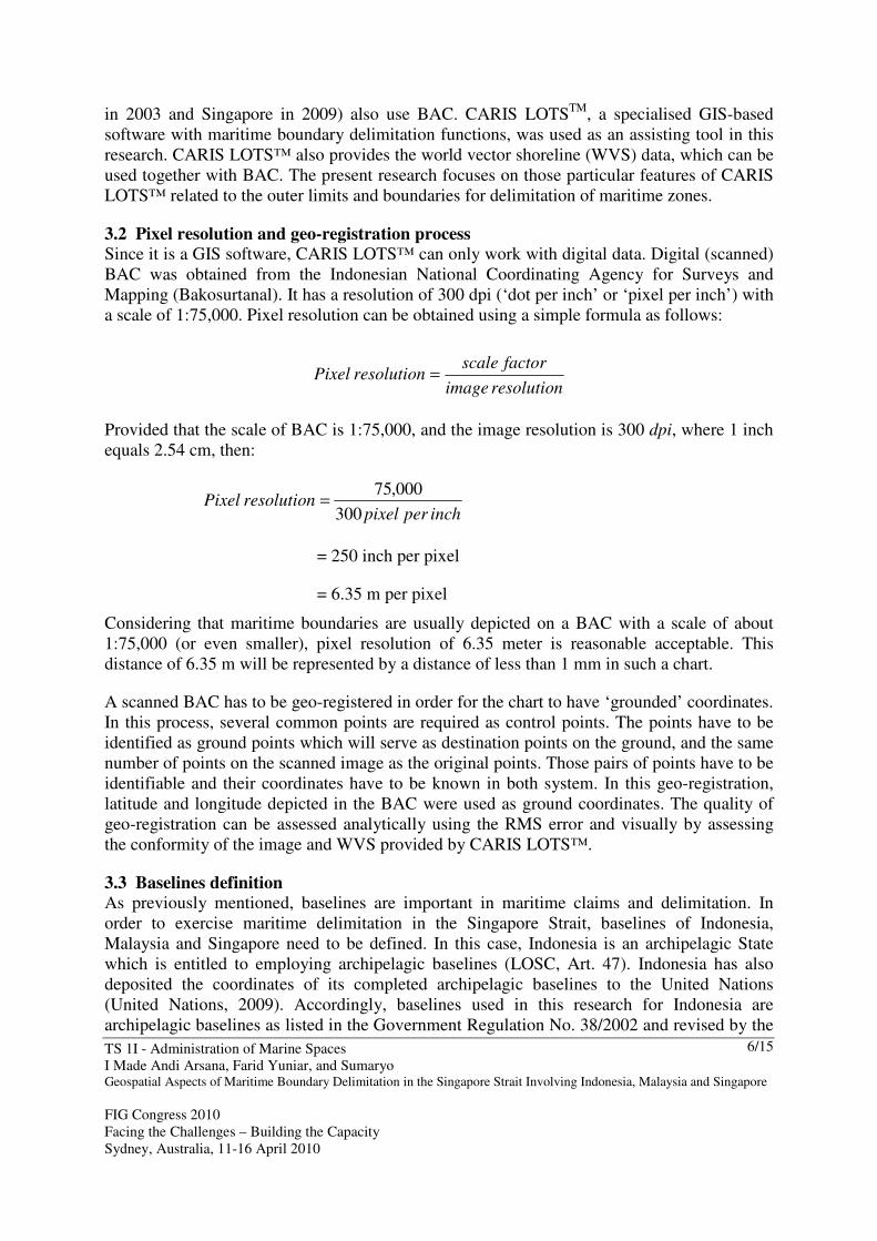
3.2 Pixel resolution and geo-registration process
Since it is a GIS software, CARIS LOTS™ can only work with digital data. Digital (scanned)
BAC was obtained from the Indonesian National Coordinating Agency for Surveys and
Mapping (Bakosurtanal). It has a resolution of 300 dpi (‘dot per inch’ or ‘pixel per inch’) with
a scale of 1:75,000. Pixel resolution can be obtained using a simple formula as follows:
resolutionimage
factorscaleresolutionPixel =
Provided that the scale of BAC is 1:75,000, and the image resolution is 300 dpi, where 1 inch
equals 2.54 cm, then:
inchperpixelresolutionPixel
300
000,75=
= 250 inch per pixel
= 6.35 m per pixel
Considering that maritime boundaries are usually depicted on a BAC with a scale of about
1:75,000 (or even smaller), pixel resolution of 6.35 meter is reasonable acceptable. This
distance of 6.35 m will be represented by a distance of less than 1 mm in such a chart.
A scanned BAC has to be geo-registered in order for the chart to have ‘grounded’ coordinates.
In this process, several common points are required as control points. The points have to be
identified as ground points which will serve as destination points on the ground, and the same
number of points on the scanned image as the original points. Those pairs of points have to be
identifiable and their coordinates have to be known in both system. In this geo-registration,
latitude and longitude depicted in the BAC were used as ground coordinates. The quality of
geo-registration can be assessed analytically using the RMS error and visually by assessing
the conformity of the image and WVS provided by CARIS LOTS™.
3.3 Baselines definition
As previously mentioned, baselines are important in maritime claims and delimitation. In
order to exercise maritime delimitation in the Singapore Strait, baselines of Indonesia,
Malaysia and Singapore need to be defined. In this case, Indonesia is an archipelagic State
which is entitled to employing archipelagic baselines (LOSC, Art. 47). Indonesia has also
deposited the coordinates of its completed archipelagic baselines to the United Nations
(United Nations, 2009). Accordingly, baselines used in this research for Indonesia are
archipelagic baselines as listed in the Government Regulation No. 38/2002 and revised by the
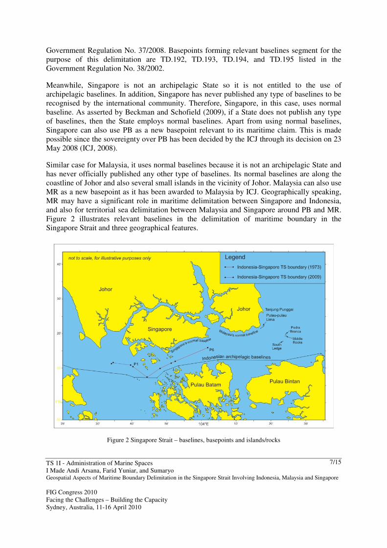
TS 1I - Administration of Marine Spaces
I Made Andi Arsana, Farid Yuniar, and Sumaryo Geospatial Aspects of Maritime Boundary Delimitation in the Singapore Strait Involving Indonesia, Malaysia and Singapore
FIG Congress 2010
Facing the Challenges – Building the Capacity
Sydney, Australia, 11-16 April 2010
7/15
Government Regulation No. 37/2008. Basepoints forming relevant baselines segment for the
purpose of this delimitation are TD.192, TD.193, TD.194, and TD.195 listed in the
Government Regulation No. 38/2002.
Meanwhile, Singapore is not an archipelagic State so it is not entitled to the use of
archipelagic baselines. In addition, Singapore has never published any type of baselines to be
recognised by the international community. Therefore, Singapore, in this case, uses normal
baseline. As asserted by Beckman and Schofield (2009), if a State does not publish any type
of baselines, then the State employs normal baselines. Apart from using normal baselines,
Singapore can also use PB as a new basepoint relevant to its maritime claim. This is made
possible since the sovereignty over PB has been decided by the ICJ through its decision on 23
May 2008 (ICJ, 2008).
Similar case for Malaysia, it uses normal baselines because it is not an archipelagic State and
has never officially published any other type of baselines. Its normal baselines are along the
coastline of Johor and also several small islands in the vicinity of Johor. Malaysia can also use
MR as a new basepoint as it has been awarded to Malaysia by ICJ. Geographically speaking,
MR may have a significant role in maritime delimitation between Singapore and Indonesia,
and also for territorial sea delimitation between Malaysia and Singapore around PB and MR.
Figure 2 illustrates relevant baselines in the delimitation of maritime boundary in the
Singapore Strait and three geographical features.
Figure 2 Singapore Strait – baselines, basepoints and islands/rocks

TS 1I - Administration of Marine Spaces
I Made Andi Arsana, Farid Yuniar, and Sumaryo Geospatial Aspects of Maritime Boundary Delimitation in the Singapore Strait Involving Indonesia, Malaysia and Singapore
FIG Congress 2010
Facing the Challenges – Building the Capacity
Sydney, Australia, 11-16 April 2010
8/15
3.4 Maritime Delimitation in the Singapore Strait
Singapore Strait is located between Malacca Strait to the west and South China Sea to the
east. The Strait is around 105 km in length and 16 km in width (measured on BAC No. 3831).
PB’s maximum length is 137 m and its width is 60 m. It is around 8,560 m2 during low tide,
situated at 1°19’48’ N and 104°24’27’’ E. The feature is located at a distance of 24 M from
the nearest point of Singapore, 7.7 M from Johor (Malaysia) and 7.6 M from Pulau Bintan
(Indonesia) (ICJ, 2008). Pedra Branca is a Portuguese word meaning “white rock”. This
might be the reason why Malaysians call it “Batu Puteh” which means “white rock”. A
lighthouse called Horsburgh was built on PB between March and October 1851.
Close to PB are MR and SL. MR is around 0.6 M to the south of PB and consists of two small
rocks which always apear during high tide, 0.6 to 1.2 meter above sea level. Those two rocks
are 250 m from each other. Meanwhile, SL is a low tide elevation (LTE) which only apears
during low tide at a distance of 2.2 M to the southwest of PB. The geographical setting of PB,
MR, and SL is illustrated in Figure 2.
Considering the geographical setting and distance among these three States, they need to
delimit their territorial sea since maximum distance separating them is no more than 24 M
from each other. Article 15 of LOSC states that if there are two or more opposite or adjacent
States with overlapping claim of territorial sea, “neither of the two opposite or adjacent States
is entitled to extend its territorial sea beyond the median line” unless either State involved
agrees otherwise, or due to the existence of “historic title or other special circumstances”. In
other words, a method acceptable for delimitation among these three States is median line or
equidistance line, unless there are special circumstances. However, PB, MR and SL can be
viewed as small islands/rocks that may cause disproportionate effect to the delimitation. This
might be considered as ‘special circumstance’ leading to the retreat from the use of
equidistance line.
Options of delimitation have been explored using different configurations of baselines and
technical and legal considerations. Boundary lines are drawn from Point 6, taken from the
1973 agreement as the starting point. Options of delimitation in the Singapore Strait are
discussed in Section 4, Result and Discussion.
3.5 Issues of South Ledge
It is interesting to observe that ICJ did not make a final decicion on SL. The decision merely
declares that the LTE belongs to the State in the territorial waters of which it is located. This
indicates that territorial sea claims by Singapore and Malaysia have to be analysed first to
define the sovereignty over SL.
In order to define the territorial sea that ‘contains’ SL, delimitation between Indonesia and
Malaysia will be performed by ignoring SL. These options of delimitation will help the
definition of the sovereignty over SL. After the definition of sovereignty, further delimitation
between Indonesia and Malaysia or between Singapore and Malaysia or between Indonesia
and Singapore can be performed by taking SL into consideration. This issues of sovereignty
over SL will influence the options of delimitation in Singapore Strait as disccussed in Section
4, Result and Discussion.
TS 1I - Administration of Marine Spaces
I Made Andi Arsana, Farid Yuniar, and Sumaryo Geospatial Aspects of Maritime Boundary Delimitation in the Singapore Strait Involving Indonesia, Malaysia and Singapore
FIG Congress 2010
Facing the Challenges – Building the Capacity
Sydney, Australia, 11-16 April 2010
9/15
3.6 Three-Junction Points in the Singapore Strait
Three-junction points or TJPs are common points connecting maritime boundary lines
between Indonesia and Singapore (The Geographer, 1974), between Indonesia and Malaysia
(The Geographer, 1970), and between Malaysia and Singapore. Relevant TJPs among the
three States will be the intersection among three boundary lines: Indonesia-Singapore,
Indonesia-Malaysia, Malaysia-Singapore. At some stages, Indonesia, Malaysia and Singapore
will need to conduct a negotiation to define the TJPs among them.
4. RESULT AND DISCUSSION
Beckman and Schofield (2009) conducted studies concerning maritime delimitation in the
Singapore Strait and provided options of maritime boundaries.1 Similarly, in April 2009,
Bakosurtanal issued a Map of the Republic of Indonesia (Peta NKRI) depicting Indonesia’s
forward position concerning maritime boundaries, including those in the Singapore Strait.
This current study also considers options proposed by Beckman and Schofield (2009) and
tentative maritime boundaries depicted in Peta NKRI 2009.
4.1 The use of different baselines
Indonesia, being an archipelagic State, can use its archipelagic baseline in boundary
delimitation. However, it is evident that in many maritime delimitation agreements,
archipelagic baselines are not given full effect in maritime delimitation. Consideration is only
given to basepoints constructing the baseline. This, for example, can be observed from the
seabed boundary between Indonesia and Thailand in the Malacca Strait and Andaman Sea
signed on 17 December 1971 (Prescott, 1993b). Accordingly, many boundary lines are
constructed using basepoints along the coast during low tide without giving full effect to
baselines constructed by those basepoints. This is one of the reasons for exploring options of
using both archipelagic and normal baselines for Indonesia in this study. Meanwhile Malaysia
and Singapore use normal baselines since they are not archipelagic States and have not
published any type of baseline other than normal baselines.
The use of two different baselines for Indonesia results in different options of boundary line,
especially in the area south of Malaysia peninsula. The use of archipelagic baselines generate
a relatively straight line, while the use of normal baselines cause the boundary line to curve
inward towards Indonesia (Pulau Batam and Bintan), generating a space of maritime area
between the two options (see Figure 4). Even though there is possibility for Malaysia to ask
Indonesia to use normal baselines, it seems that Indonesia will most likely prefer archipelagic
baselines. It has two strong reasons: a) Indonesia has been recognised as an archipelagic State
and has also deposited its completed archipelagic baselines to the United Nations and b)
giving a full effect to the archipelagic baselines is clearly more advantageous for Indonesia.
4.2 Pedra Branca, Middle Rock and South Ledge
The weight given to PB, MR and SL is another issue in maritime delimitation in the
Singapore Strait. An important thing to deal with is the status of PB, whether or not it is an
1 The first Author of this paper provided technical assistance in dealing with mapping aspects of the research
conducted by Beckman and Schofield (2009).
TS 1I - Administration of Marine Spaces
I Made Andi Arsana, Farid Yuniar, and Sumaryo Geospatial Aspects of Maritime Boundary Delimitation in the Singapore Strait Involving Indonesia, Malaysia and Singapore
FIG Congress 2010
Facing the Challenges – Building the Capacity
Sydney, Australia, 11-16 April 2010
10/15
island according to the LOSC, Article 121. Should PB be considered as an island, it is entitled
to a full suit of maritime jurisdictions. However, there will always be possibility for
Indonesia, for example, to argue that this small island should not be given full effect in
maritime delimitation because it may cause disproportionate effect (Beckman and Schofield,
2009).
As in the case of MR, it might be reasonably acceptable to consider it as a rock that is still
entitled to a territorial sea. In delimiting maritime boundaries between Malaysia and Indonesia
to the south of MR, Indonesia might view that the small rock should not be given full effect,
while it maintains the use of archipelagic baselines. Meanwhile, it does not matter which State
will be awarded SL (either Malaysia or Singapore), it is a low tide elevation, to which
Indonesia may prefer not to give full effect in maritime delimitation. This view is confirmed
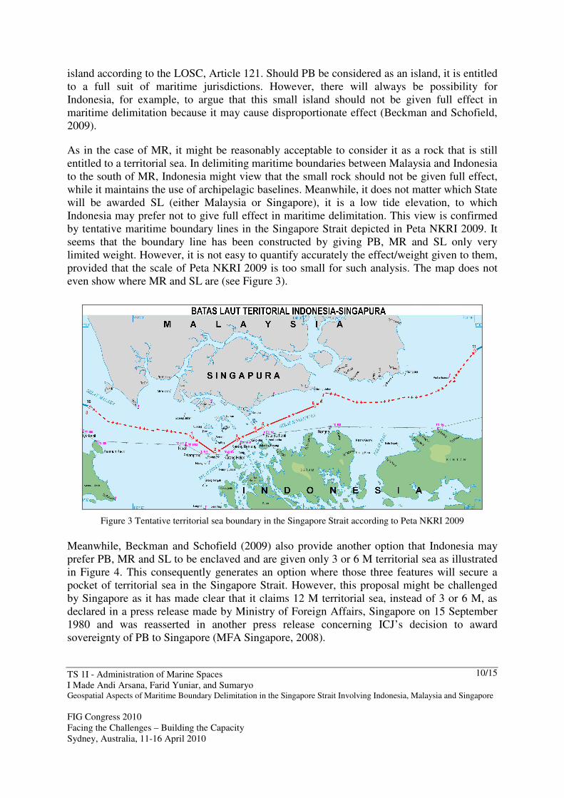
by tentative maritime boundary lines in the Singapore Strait depicted in Peta NKRI 2009. It
seems that the boundary line has been constructed by giving PB, MR and SL only very
limited weight. However, it is not easy to quantify accurately the effect/weight given to them,
provided that the scale of Peta NKRI 2009 is too small for such analysis. The map does not
even show where MR and SL are (see Figure 3).
Figure 3 Tentative territorial sea boundary in the Singapore Strait according to Peta NKRI 2009
Meanwhile, Beckman and Schofield (2009) also provide another option that Indonesia may
prefer PB, MR and SL to be enclaved and are given only 3 or 6 M territorial sea as illustrated
in Figure 4. This consequently generates an option where those three features will secure a
pocket of territorial sea in the Singapore Strait. However, this proposal might be challenged
by Singapore as it has made clear that it claims 12 M territorial sea, instead of 3 or 6 M, as
declared in a press release made by Ministry of Foreign Affairs, Singapore on 15 September
1980 and was reasserted in another press release concerning ICJ’s decision to award
sovereignty of PB to Singapore (MFA Singapore, 2008).

TS 1I - Administration of Marine Spaces
I Made Andi Arsana, Farid Yuniar, and Sumaryo Geospatial Aspects of Maritime Boundary Delimitation in the Singapore Strait Involving Indonesia, Malaysia and Singapore
FIG Congress 2010
Facing the Challenges – Building the Capacity
Sydney, Australia, 11-16 April 2010
11/15
Figure 4 Maritime boundary options in the Singapore Strait
4.3 EEZ option for Singapore
Having generated a strictly equidistant line by giving full effect to all geographical features
and baselines, it is identified that there is possibility for Singapore to claim EEZ from PB.
This will only be made possible, however, if PB is officially recognised as an island according
to LOSC Article 121 and not merely a rock. Strictly equidistant lines among the three States
in the region possibly form a triangle area of EEZ for Singapore to the north east of PB,
beyond its territorial sea. By assuming PB is entitled to a 12 M territorial sea, the triangle of
EEZ may account for around 160 square kilometres (geodetic), based on a calculation on
BAC-3831 assisted by CARIS LOTS™. This would mean that PB will secure a pocket of
territorial sea and a pocket of EEZ.
However, the EEZ option for Singapore might not be seen acceptable to Indonesia because
PB is only a small island/rock, which should not cause disproportionate effect in maritime
claims and delimitation. In addition, PB may not satisfy requirements to be recognised as an
island according to LOSC Article 121 (Bernama, 2008). Should PB be merely considered a
rock that cannot “sustain human habitation”, the maximum claim that it can make would be
12 M territorial sea. It does not matter whether PB is an island or rock, Indonesia does not
consider it in maritime delimitation. This can be inferred from Peta NKRI 2009 depicting
tentative boundary lines ignoring PB in the Singapore Strait.
4.4 Geospatial aspects
The 1973 agreement between Indonesia and Singapore does not specify geodetic datum.
However, the 2009 agreement seems to have addressed the issue by mentioning WGS84 as
the datum. This standard will, ideally, be followed by future maritime agreements in the
Singapore Strait. The certainty of geodetic datum will help authorities in defining the actual
boundary in the field, as usually mandated by the agreements. For practical reasons, a

TS 1I - Administration of Marine Spaces
I Made Andi Arsana, Farid Yuniar, and Sumaryo Geospatial Aspects of Maritime Boundary Delimitation in the Singapore Strait Involving Indonesia, Malaysia and Singapore
FIG Congress 2010
Facing the Challenges – Building the Capacity
Sydney, Australia, 11-16 April 2010
12/15
mechanism of locating lines or points identified in the 1973 agreement out in the field is
required because the agreement did not specify any geodetic datum. In relation to this, Abidin
et al (2005) proposed a mechanism in transforming existing geodetic datum of Indonesia’s
maritime boundaries into WGS84. This global datum of WGS84 is preferred because it is
compatible to modern navigation technology such as GPS. Accordingly, the use of modern
technology will help users of the Singapore Strait to navigate in the strait without crossing
State borders unintentionally. In addition, it will also assist authorities in conducting law
enforcement with the help of modern navigation technology.
Another geospatial aspect to be taken into consideration is the use of straight line types for the
agreement. Technically, there are more than one type of straight line that can be used such as
geodesic, loxodrome, or chord line. A clear definition of line types used to connect points
(baseline, boundary lines) in an agreement is important since each line can be significantly
different compared to the other (Arsana and Sumaryo, 2008). Over a long distance, the
differences can accumulate significantly. In this case the same two turning points can generate
different lines depending on type of lines used to connect the two points.
5. CONCLUDING REMARKS
The success of Indonesia and Singapore in establishing maritime boundaries through the
series of negotiations is an example of good bilateral relationship. Similarly, the decision of
ICJ on the sovereignty over the three disputed geographical features: PB, MR, and SL is also
a good achievement by Malaysia and Singapore. All of these may facilitate the completion of
maritime delimitation in the Singapore Strait involving Indonesia, Malaysia and Singapore.
Geospatial analysis has been conducted to exercise maritime delimitation in the Singapore
Strait. It has been identified that the three States in the region have to delimit their territorial
sea, and potentially EEZ. Different options of maritime boundaries may be achieved
depending on, among others, baselines used in the delimitation. Indonesia, in this case, is
entitled to the use of archipelagic baseline, while Singapore and Malaysia use normal
baselines. However, Singapore and Malaysia can use the newly-secured PB and MR for their
basepoints, respectively. In addition, options of delimitation can also be achieved by giving
different weight to small geographical features (i.e. PB, MR and SL). While Singapore and
Malaysia might prefer to give full effect to them, Indonesia might view that full effect may
cause disproportionate affect to their maritime boundaries. This seems to be one of the issues
that will be discussed intensively by the three States in the future negotiations.
Notwithstanding the fact that maritime delimitation in the Strait of Singapore is far from
automatic, this is the time for prioritising the process. Negotiation process started by Malaysia
and Singapore should subsequently involve Indonesia. In the end, the final and binding
maritime boundaries in the Singapore Strait have to be agreed upon by the all three States:
Indonesia, Malaysia and Singapore. This is a scientific study that does not consider political
aspects of the case. This is aimed at providing alternative methods of delimitations that might
be considered by Indonesia, Malaysia and Singapore in negotiating their maritime boundaries.
The final and binding agreement will, however, exclusively be decided by the three States
involved.
TS 1I - Administration of Marine Spaces
I Made Andi Arsana, Farid Yuniar, and Sumaryo Geospatial Aspects of Maritime Boundary Delimitation in the Singapore Strait Involving Indonesia, Malaysia and Singapore
FIG Congress 2010
Facing the Challenges – Building the Capacity
Sydney, Australia, 11-16 April 2010
13/15
6. ACKNOWLEDGEMENT
The authors are grateful for geospatial data supplied by Bakosurtanal and research facility
provided by the Department of Geodetic Engineering, Gadjah Mada University. The license
of CARIS LOTS™ used in this research belongs to the School of Surveying and SIS,
University of New South Wales and Australian National Centre for Ocean Resources and
Security (ANCORS), University of Wollongong. The authors deeply appreciate their
contribution and assistance.
REFERENCES
Abidin, Hasanuddin Z., Sutisna, S., Padmasari, T., Villanueva, K. J. and Kahar, J., 2005,
Geodetic Datum of Indonesian Maritime Boundaries: Status and Problems, Marine
Geodesy, 28:4, pp. 291- 304.
Act No. 18, 2007 on Ratification of the Agreement Between The Government Of The
Republic Of Indonesia And The Government Of The Socialist Republic Of Vietnam
Concerning The Delimitation Of The Continental Shelf Boundary, 2003 [Pengesahan
Persetujuan Antara Pemerintah RI Dan Pemerintah Republik Sosialis Vietnam Tentang
Penetapan Batas Landas Kontinen, 2003], 15 March 2007. Available at <
http://www.djpp.depkumham.go.id/inc/buka.php?czoyNDoiZD0yMDAwKzcmZj11dT
E4LTIwMDcuaHRtIjs=>.
Arsana, IMA. and Schofield, C., 2009, Extending Indonesia? Opportunities and Challenges
Related to the Definition of Indonesia’s Extended Continental Shelf Rights, in Cribb, R.
and Ford, M. (eds) Indonesia Beyond the Water's Edge, Singapore ISEAS Publications.
Arsana, IMA. and Sumaryo, 2008 Geospatial Aspects of Indonesia’s International Maritime
Boundaries in Relation to Border Management [Aspek Geospasial Batas Maritim
Internasional Indonesia dalam Pengelolaan Wilayah Perbatasan], Seminar and
Workshop on “Border Area Management”, Yogyakarta, Universitas Pembangunan
Nasional ”Veteran”.
Arsana, IMA., 2007, International Maritime Boundaries: A Technical and Juridical
Perspective [Batas Maritime Antarnegara: Sebuah Tinjauan Teknis dan Yuridis],
Yogyakarta, Indonesia, Gadjah Mada University Press.
Beckman, R., and Schofield, C., 2009, Moving Beyond Disputes Over Island Sovereignty:
ICJ Decision Sets Stage for Maritime Boundary Delimitation in the Singapore Strait,
Ocean Development & International Law,40:1,1-35.
Bernama, 2008, Singapore's Bid To Claim Territorial Sea Around Batu Puteh Unlawful, Says
Legal Expert, Kuala Lumpur. Available at <
http://www.bernama.com/bernama/v3/news_lite.php?id=348052>.
CLCS/11, 1999, Scientific and Technical Guidelines of the Commission on the Limits of the
Continental Shelf.
Ho, J.H., 2006, The Security of Sea Lanes in Southeast Asia, Asian Survey, Vol. 46, No. 4
(Jul. - Aug., 2006), pp. 558-574, United States of America, University of California
Press.
ICJ, 2008, Sovereignty over Pedra Branca/Pulau Batu Puteh, Middle Rocks and South Ledge
(Malaysia/Singapore). International Court of Justice (ICJ), the Netherlands. Available at
<http://www.icj-cij.org/docket/files/130/14492.pdf>.

TS 1I - Administration of Marine Spaces
I Made Andi Arsana, Farid Yuniar, and Sumaryo Geospatial Aspects of Maritime Boundary Delimitation in the Singapore Strait Involving Indonesia, Malaysia and Singapore
FIG Congress 2010
Facing the Challenges – Building the Capacity
Sydney, Australia, 11-16 April 2010
14/15
IHB, 2006. A Manual on Technical Aspects of the United Convention on the Law of the Sea,
Special Publication No 51, 4th edition, Monaco, International Hydrographic
Organization (IHO).
MFA Indonesia, 2009, Press Release: The Signing of The Treaty Between The Republic of
Indonesia and The Republic of Singapore Relating to The Delimitation of The
Territorial Seas In The Western Part of The Strait of Singapore, Jakarta, 10 March.
Available at < http://www.deplu.go.id/_layouts/mobile/PortalDetail-
PressReleaseLike.aspx?l=en&ItemId=c148acb8-88c6-4e24-9dd3-352ec9cd90c2>.
MFA Singapore, 2008. Ministry of Foreign Affairs Press Statement: International Court of
Justice Awards Sovereignty of Pedra Branca to Singapore, 23 May 2008. Available at
<http://app.mfa.gov.sg/pr/read_content.asp?View,10195,>.
Park, C., 1993, Indonesia-Singapore in Charney J.I. and Alexander L.M. (eds) International
Maritime Boundaries, pp. 1049-1056, the Netherlands, Martinus Nijhoff Publishers.
Pratt, M., 2009, Personal communication with Dr. Martin Pratt on 13 February 2009. Martin
Pratt is the Director of Research of the International Boundary Research Unit (IBRU)
University of Durham, UK.
Prescott, JRV. and Schofield, C., 2005, The Maritime Political Boundaries of the World,
Second Edition, Martinus Nijhoff Publishers.
Prescott, JRV., 1993a, Australia-Indonesia (Seabed Boundaries) in Charney J.I. and
Alexander L.M. (eds) International Maritime Boundaries, pp. 1195-1205, the
Netherlands, Martinus Nijhoff Publishers.
Prescott, JRV., 1993b, Indonesia- Thailand (Malacca Strait and Andaman Sea) in Charney J.I.
and Alexander L.M. (eds) International Maritime Boundaries, pp. 1445-1463, the
Netherlands, Martinus Nijhoff Publishers.
Prescott, JRV., 1997, The completion of marine boundary delimitation between Australia and
Indonesia, Geopolitics, Vol. 2 No. 2, pp. 132 – 149.
Pruett, L. 2004. Area Calculations of the Claims and Potential Claims to Offshore
Jurisdictional Zones and High Seas, unpublished data derived from the August 2003
Edition of the Global Maritime Boundaries Database, General Dynamics, Herndon, VA,
USA, in Prescott, V. and Schofield, C. 2005. The Maritime Political Boundaries of the
World, 2nd edition, Martinus Nijhoff Publishers.
S. Bateman, J. H. Ho, and M. Mathai, 2007, Shipping Patterns in the Straits of Malacca and
Singapore: An Assessment of the Risks to Different Types of Vessel, Contemporary
Southeast Asia 29, pp 309–332, at 325.
The Geographer, 1970, Continental Shelf Boundary: Indonesia –Malaysia, Limit in the Seas,
Department of States, The Geographer, Washington D.C.
The Geographer, 1974, Territorial Sea Boundary: Indonesia – Singapore, Limit in the Seas,
Department of States, The Geographer, Washington D.C.
United Nations, 1982, United Nation Convention on the Law of the Sea 1982, Montego Bay,
Jamaica.
United Nations, 2009, Chronological lists of ratifications of, accessions and successions to the
Convention and the related Agreements as at 06 November 2009. Available at
<http://www.un.org/Depts/los/reference_files/chronological_lists_of_ratifications.htm>.
United Nations, 2009, Deposit of a list of geographical coordinates of points of the Indonesian
Archipelagic Baselines based on the Government Regulation of the Republic of

TS 1I - Administration of Marine Spaces
I Made Andi Arsana, Farid Yuniar, and Sumaryo Geospatial Aspects of Maritime Boundary Delimitation in the Singapore Strait Involving Indonesia, Malaysia and Singapore
FIG Congress 2010
Facing the Challenges – Building the Capacity
Sydney, Australia, 11-16 April 2010
15/15
Indonesia Number 38 of 2002 as amended by the Government Regulation of the
Republic of Indonesia Number 37 of 2008, Law of the Sea Bulletin No. 69.
Xinhua, 2010, Singapore, Malaysia meet to settle island dispute, available at
<http://news.xinhuanet.com/english/2010-01/08/content_12776298.htm>.
BIOGRAPHICAL NOTES
I Made Andi Arsana
Andi is currently an Australian Leadership Awards Scholar (PhD candidate) at the Australian
National Centre for Ocean Resources and Security (ANCORS), University of Wollongong.
His permanent position is a lecturer and researcher in the Department of Geodetic
Engineering, Gadjah Mada University, Indonesia. Andi has been focusing his research on
technical/geodetic aspects of the law of the sea, especially those concerning maritime
boundary delimitation. He has published around several works in the field including, journals,
books, newspaper articles, conferences, invited talks, seminars, etc., both in English and
Bahasa Indonesia. More information about Andi can be obtained from his website:
http://madeandi.staff.ugm.ac.id
CONTACTS Mr. I Made Andi Arsana
Gadjah Mada University, Indonesia
-------------------------------------------------
University of Wollongong
Innovation Campus
Fairy Meadow, 2519, NSW, Australia
P: +61 2 4221 5831
F: +61 2 4221 5544
Email: [email protected]
Website: http://madeandi.staff.ugm.ac.id


