Download - GeoServer on Steroids - FOSS4G 2015

GeoServer on steroids All you wanted to know
about how to make GeoServer faster
but you never asked
(or you did and no one answered)
Ing. Andrea Aime
Ing. Simone Giannecchini GeoSolutions

GeoSolutions
Founded in Italy in late 2006
Expertise
• Image Processing, GeoSpatial Data Fusion
• Java, Java Enterprise, C++, Python
• JPEG2000, JPIP, Advanced 2D visualization
Supporting/Developing FOSS4G projects GeoServer, MapStore
GeoNetwork, GeoNode, Ckan
Clients
Public Agencies
Private Companies
http://www.geo-solutions.it
FOSS4G 2015, Seoul 14th-19th September 2015
Contents
Preparing raster data
Preparing vector data
Optimizing styling
Output tuning
Tiling and caching
Resource control
Deploy configurations
FOSS4G 2015, Seoul 14th-19th September 2015

Preparing raster inputs
FOSS4G 2015, Seoul 14th-19th September 2015

Raster data checklist
FOSS4G 2015, Seoul 14th-19th September 2015
Objectives
Fast extraction of a subset of the data
Fast extraction of the desired resolution
Check-list
Avoid having to open a large number of files per request
Avoid parsing of complex structures and slow compressions
Get to know your bottlenecks
CPU vs Disk Access Time vs Memory
Experiment with
Format, compression, different color models, tile size, overviews, GeoServer configuration

Problematic input formats
FOSS4G 2015, Seoul 14th-19th September 2015
PNG/JPEG direct serving
Bad formats (especially in Java)
No tiling (or rarely supported)
Chew a lot of memory and CPU for decompression
Mitigate with external overviews
Any input ASCII format (GML grid, ASCII grid)
JPEG2000
Extensible and rich, not (always) fast, can be difficult to tune for performance (might require specific encoding options)
MrSID (can work, needs tuning)
ECW (licensing issues)

GeoTIFF for the win
FOSS4G 2015, Seoul 14th-19th September 2015
To remember: GeoTiff is a swiss knife
But you don’t want to cut a tree with it!
Tremendously flexible, good for for most (not all) use cases
BigTiff pushes the GeoTiff limits farther
Use GeoTiff when
Overviews and Tiling stay within 4GB
No additional dimensions
Consider BigTiff for very large file (> 4 GB)
Support for tiling
Support for Overviews
Can be inefficient with very large files + small tiling

GeoTIFF preparation
FOSS4G 2015, Seoul 14th-19th September 2015
(Optional) Use gdal_warp to transform the data in
the most used output reference system (mind, any reprojection ruins the data a bit)
Use gdal_translate to add inner tiling and fix
eventual issues with coordinate reference system
Add compression options if you disks are small/slow/not local (consider JPEG compression with YCBCR color interpretation for photos, LZW/Deflate for scientific data)
Use gdaladdo to add internal overviews (remember
to replicate compression here)

Possible structures
FOSS4G 2015, Seoul 14th-19th September 2015
Single GeoTiff with internal tiling
and overviews
(GeoTiff < 2GB,
BigTiff < 20-50GB)
Mosaic of GeoTiff, each one
with internal tiling and overviews
(< 500GB, not too many files) Pyramid
1
2
3
Choosing formats and layouts
FOSS4G 2015, Seoul 14th-19th September 2015
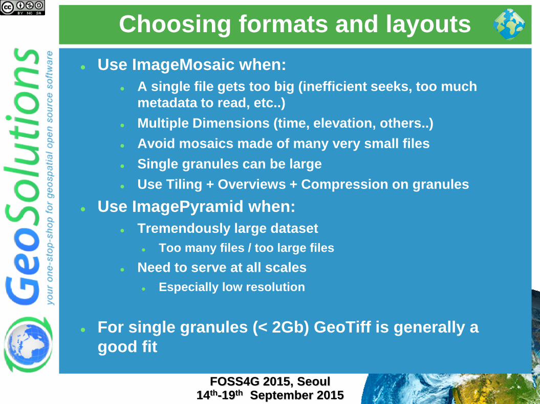
Use ImageMosaic when:
A single file gets too big (inefficient seeks, too much
metadata to read, etc..)
Multiple Dimensions (time, elevation, others..)
Avoid mosaics made of many very small files
Single granules can be large
Use Tiling + Overviews + Compression on granules
Use ImagePyramid when:
Tremendously large dataset
Too many files / too large files
Need to serve at all scales
Especially low resolution
For single granules (< 2Gb) GeoTiff is generally a
good fit

Proper mosaic preparation
FOSS4G 2015, Seoul 14th-19th September 2015
Optimize files as if you were serving them individually
Keep a balance between number and dimensions of
granules
If memory is scarce: USE_JAI_IMAGREAD to true
USE_MULTITHREADING to false*
Otherwise USE_JAI_IMAGREAD to false
ALLOW_MULTITHREADING
to true (Load data from
different granules in parallel)

Multidimensional mosaics
FOSS4G 2015, Seoul 14th-19th September 2015
Use Cases:
MetOc data (support for time, elevation)
Data with additional indipendent dimensions
Suggestions
Use ImageMosaic
Use a DBMS for indexing granules (not shapefile)
Add indexes on the dimension columns
Use File Name based property collectors to turn properties
into DB rows attributes
Filter by time, elevation and other attributes via OGC and
CQL filters
Check detailed deck for details!

Multidimensional mosaics
FOSS4G 2015, Seoul 14th-19th September 2015
Proper pyramid preparation
FOSS4G 2015, Seoul 14th-19th September 2015
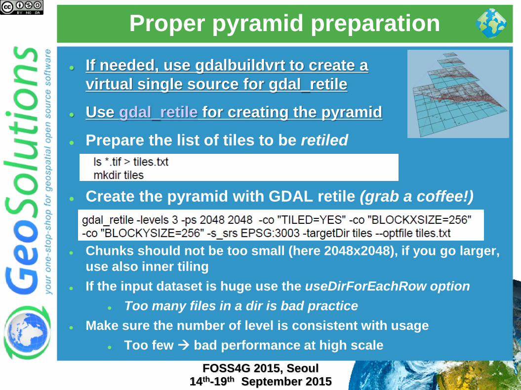
If needed, use gdalbuildvrt to create a
virtual single source for gdal_retile
Use gdal_retile for creating the pyramid
Prepare the list of tiles to be retiled
Create the pyramid with GDAL retile (grab a coffee!)
Chunks should not be too small (here 2048x2048), if you go larger,
use also inner tiling
If the input dataset is huge use the useDirForEachRow option
Too many files in a dir is bad practice
Make sure the number of level is consistent with usage
Too few bad performance at high scale
Preparing vector inputs
FOSS4G 2015, Seoul 14th-19th September 2015
Vector data checklist
FOSS4G 2015, Seoul 14th-19th September 2015
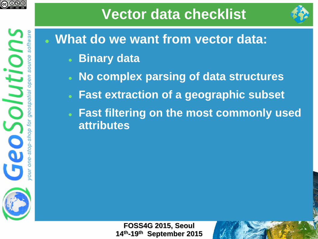
What do we want from vector data:
Binary data
No complex parsing of data structures
Fast extraction of a geographic subset
Fast filtering on the most commonly used attributes

Choosing a format
FOSS4G 2015, Seoul 14th-19th September 2015
Slow formats
WFS
GML
DXF
Good formats, local and
indexable
Shapefile
Directory of
shapefiles
SDE
Spatial databases:
PostGIS, Oracle
Spatial, DB2, SQL
server, MySQL*

DBMS checklist
FOSS4G 2015, Seoul 14th-19th September 2015
Choose PostGIS if you can
Rich support for complex native filters
Use connection pooling
Validate connections (with proper pooling)
Table Clustering
Spatial Indexing
Spatial Indexing
Spatial Indexing
Alphanumeric Indexing
Alphanumeric Indexing
Alphanumeric Indexing
Did we mention indexes?

Connection pooling tricks
FOSS4G 2015, Seoul 14th-19th September 2015
Connection pool size should be proportional to the
number of concurrent requests you want to serve (obvious
no?)
Activate connection validation
Mind networking tools that might cut connections sitting
idle (yes, your server is not always busy), they might cut
the connection in “bad” ways (10 minutes timeout before
the pool realizes the TCP connection attempt gives up)
Read more at http://geoserver.geo-
solutions.it/edu/en/adv_gsconfig/db_pooling.html
Shapefile preparation
FOSS4G 2015, Seoul 14th-19th September 2015
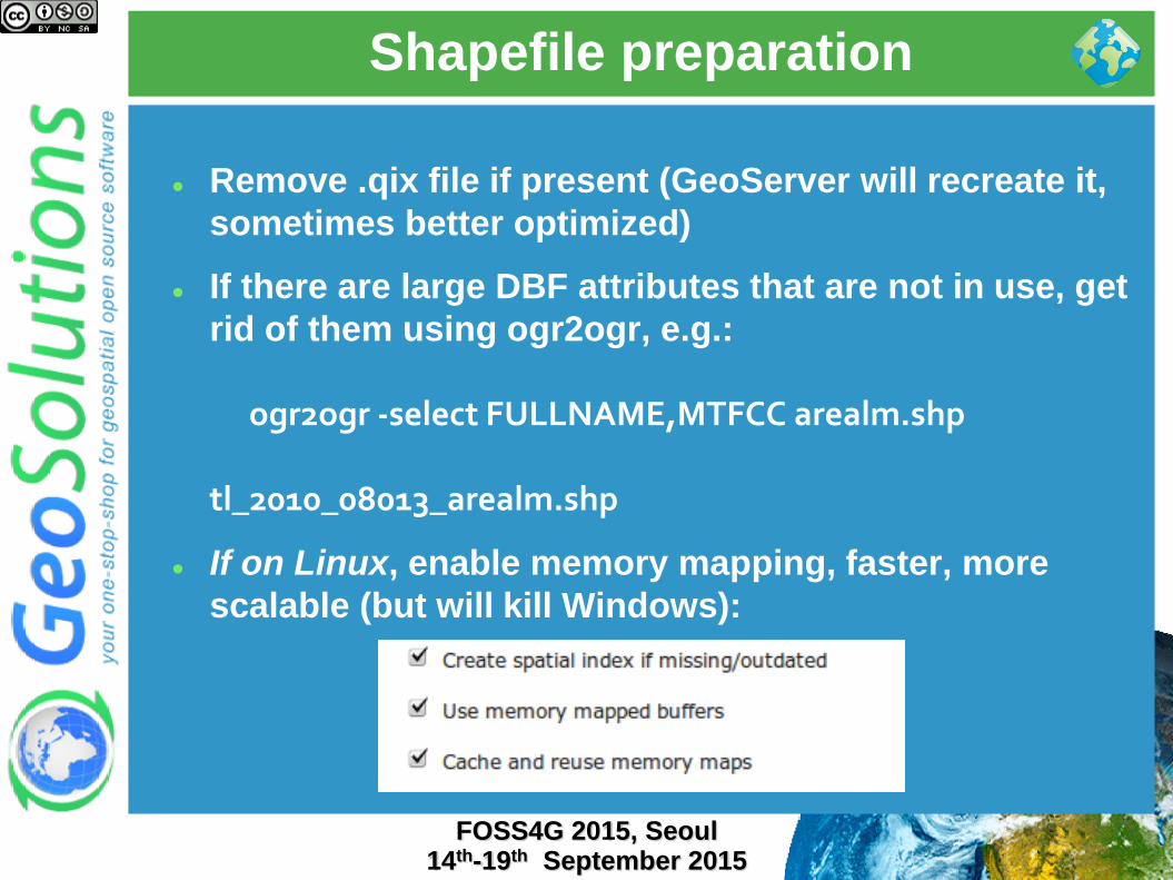
Remove .qix file if present (GeoServer will recreate it,
sometimes better optimized)
If there are large DBF attributes that are not in use, get
rid of them using ogr2ogr, e.g.:
ogr2ogr -select FULLNAME,MTFCC arealm.shp tl_2010_08013_arealm.shp
If on Linux, enable memory mapping, faster, more
scalable (but will kill Windows):

Shapefile filtering
FOSS4G 2015, Seoul 14th-19th September 2015
Stuck with shapefiles and have scale dependent
rules like the following?
Show highways first
Show all streets when zoomed in
Use ogr2ogr to build two shapefiles, one with just
the highways, one with everything, and build two
layers, e.g.:
ogr2ogr -sql "SELECT * FROM
tl_2010_08013_roads WHERE MTFCC in
('S1100', 'S1200')" primaryRoads.shp
tl_2010_08013_roads.shp
Or hire us to develop non-spatial indexing for
shapefile!

Optimize styling
FOSS4G 2015, Seoul 14th-19th September 2015

Use scale dependencies
FOSS4G 2015, Seoul 14th-19th September 2015
Never show too much data
the map should be readable, not a graphic blob. Rule of thumb: 1000 features max in the display, have labels show up when zoomed in
Show details as you zoom in
Eagerly add MinScaleDenominator to your SLD rules
Add more expensive rendering when there are less features
Key to get both a good looking and fast map

Labeling
FOSS4G 2015, Seoul 14th-19th September 2015
Labeling conflict resolution is expensive, limit to the
most inner zooms
Halo is important for readability, but adds overhead
Careful with maxDisplacement, makes for various
label location attempts

FeatureTypeStyle
FOSS4G 2015, Seoul 14th-19th September 2015
GeoServer uses SLD FeatureTypeStyle objects as Z
layers for painting
Each one allocates its own rendering surface (which
can use a lot of memory), use as few as possible

z-ordering
FOSS4G 2015, Seoul 14th-19th September 2015
Use DBMS as the data source
Add indexes on the fields used for z-ordering
If at all possible, use cross-feature type and cross-layer
z-ordering on small amounts of data (we need to go
back and forth painting it)

Tiling and caching
FOSS4G 2015, Seoul 14th-19th September 2015

Tile caching with GWC
FOSS4G 2015, Seoul 14th-19th September 2015
Tile oriented maps, fixed zoom levels and fixed grid
Useful for stable layers, backgrounds
Protocols: WMTS, TMS, WMS-C, Google Maps/Earth, VE
Speedup compared to dynamic WMS: 10 to 100 times, assuming tiles are already cached (whole layer pre-seeded)
Suitable for:
Mostly static layer
No/few dynamic parameters (CQL filters, SLD params, SQL query params, time/elevation, format options)

Embedded GWC advantage
FOSS4G 2015, Seoul 14th-19th September 2015
No double encoding when using meta-tiling, faster
seeding
Space considerations
FOSS4G 2015, Seoul 14th-19th September 2015
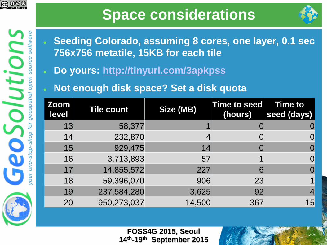
Seeding Colorado, assuming 8 cores, one layer, 0.1 sec
756x756 metatile, 15KB for each tile
Do yours: http://tinyurl.com/3apkpss
Not enough disk space? Set a disk quota
Zoom
level Tile count Size (MB)
Time to seed
(hours)
Time to
seed (days)
13 58,377 1 0 0
14 232,870 4 0 0
15 929,475 14 0 0
16 3,713,893 57 1 0
17 14,855,572 227 6 0
18 59,396,070 906 23 1
19 237,584,280 3,625 92 4
20 950,273,037 14,500 367 15
Client side cache
FOSS4G 2015, Seoul 14th-19th September 2015
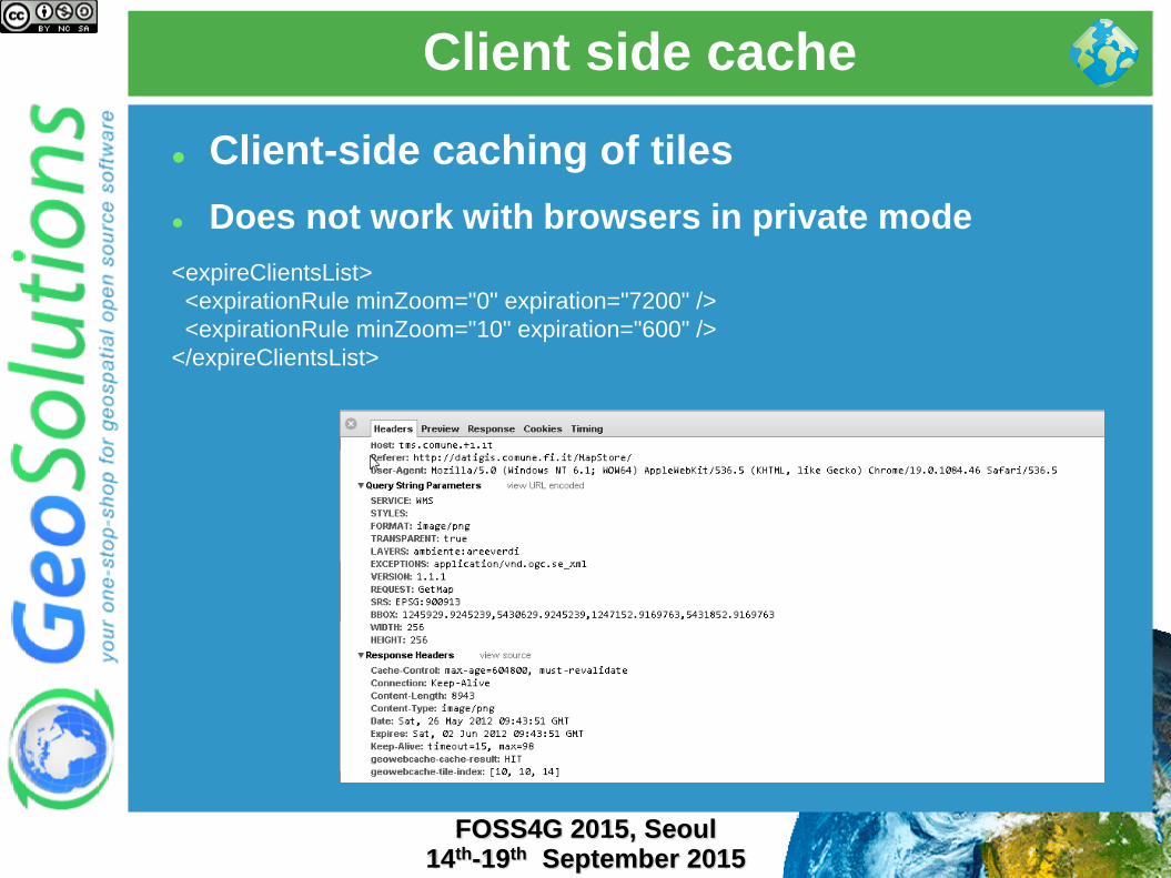
Client-side caching of tiles
Does not work with browsers in private mode
<expireClientsList>
<expirationRule minZoom="0" expiration="7200" />
<expirationRule minZoom="10" expiration="600" />
</expireClientsList>

Choose the right format
FOSS4G 2015, Seoul 14th-19th September 2015
Use the right formats
JPEG for background data (e.g. ortos)
PNG8 + precomputed palette for
background data (e.g. ortos)
PNG8 full for overlays with transparency
The format impacts also the disk space
needed! (as well as the generation time)
Check this blog post

Keep an eye on vector tiles
FOSS4G 2015, Seoul 14th-19th September 2015
New community module to support vector tiles
Still new, but:
PNG encoding is often 50% of the request
time when there is little data in the tile
Gone with Vector tiles
Vector tiles are more compact

Resource control
FOSS4G 2015, Seoul 14th-19th September 2015
Resource limits
FOSS4G 2015, Seoul 14th-19th September 2015
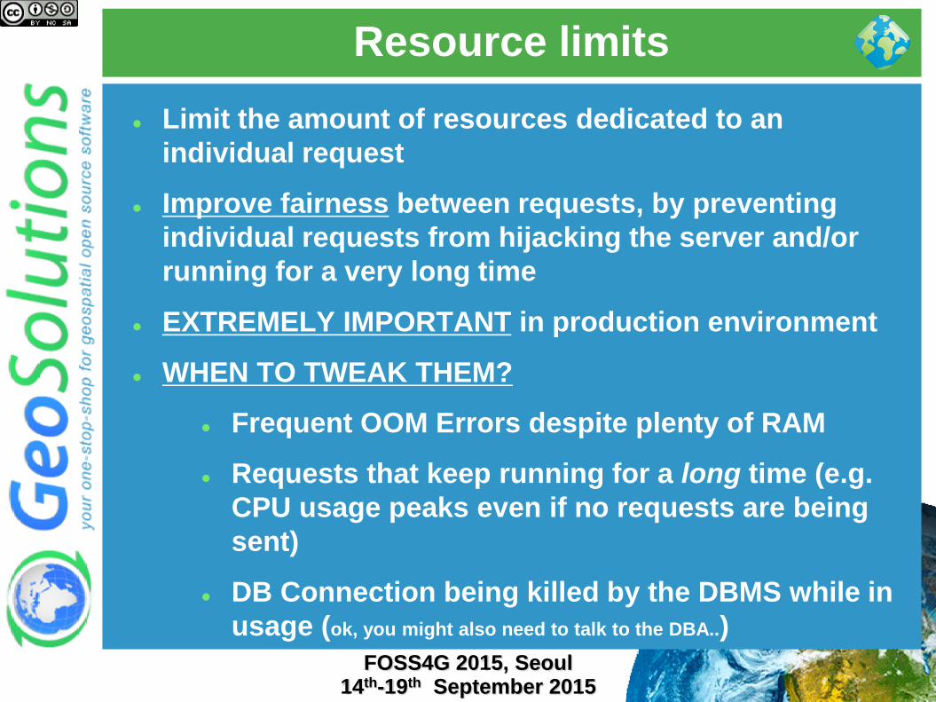
Limit the amount of resources dedicated to an
individual request
Improve fairness between requests, by preventing
individual requests from hijacking the server and/or
running for a very long time
EXTREMELY IMPORTANT in production environment
WHEN TO TWEAK THEM?
Frequent OOM Errors despite plenty of RAM
Requests that keep running for a long time (e.g.
CPU usage peaks even if no requests are being
sent)
DB Connection being killed by the DBMS while in
usage (ok, you might also need to talk to the DBA..)

Resource limits
FOSS4G 2015, Seoul 14th-19th September 2015
WMS
WFS WCS
Control-flow
FOSS4G 2015, Seoul 14th-19th September 2015
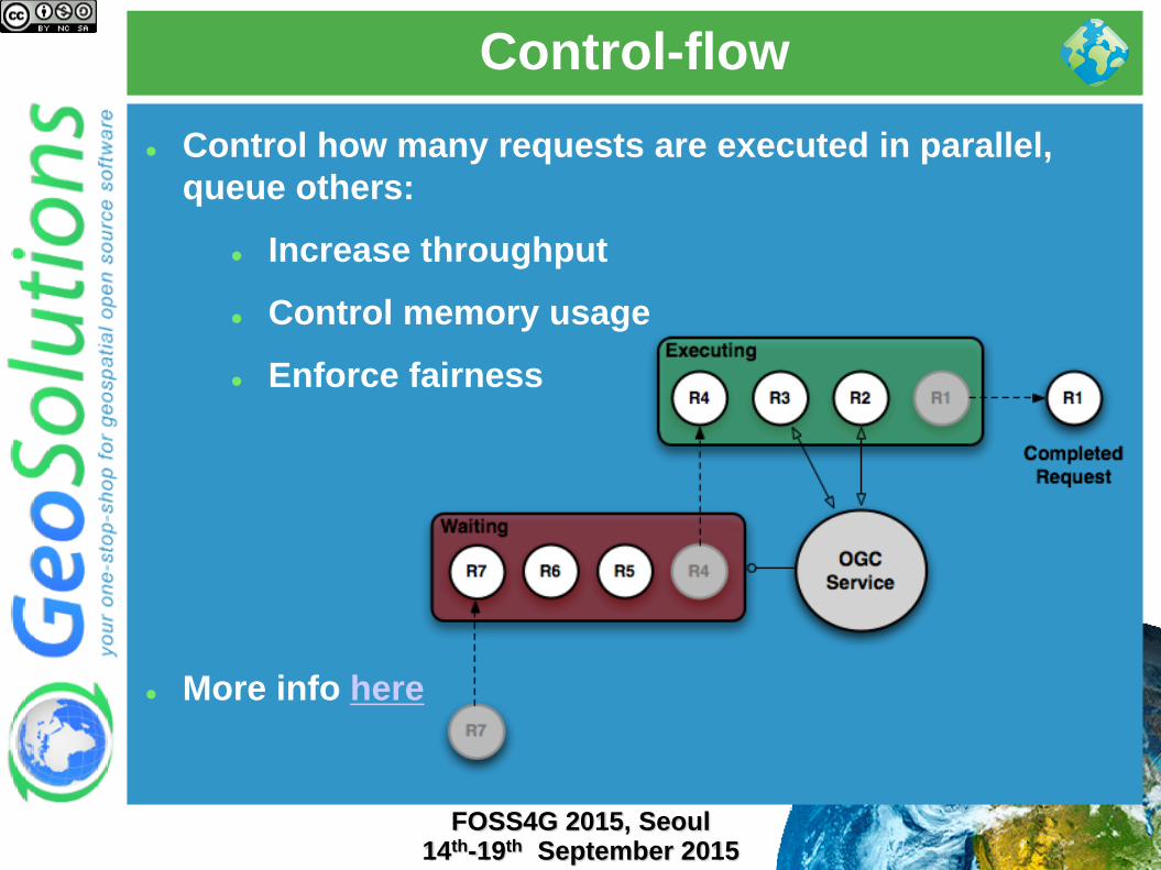
Control how many requests are executed in parallel,
queue others:
Increase throughput
Control memory usage
Enforce fairness
More info here
Control-flow
FOSS4G 2015, Seoul 14th-19th September 2015
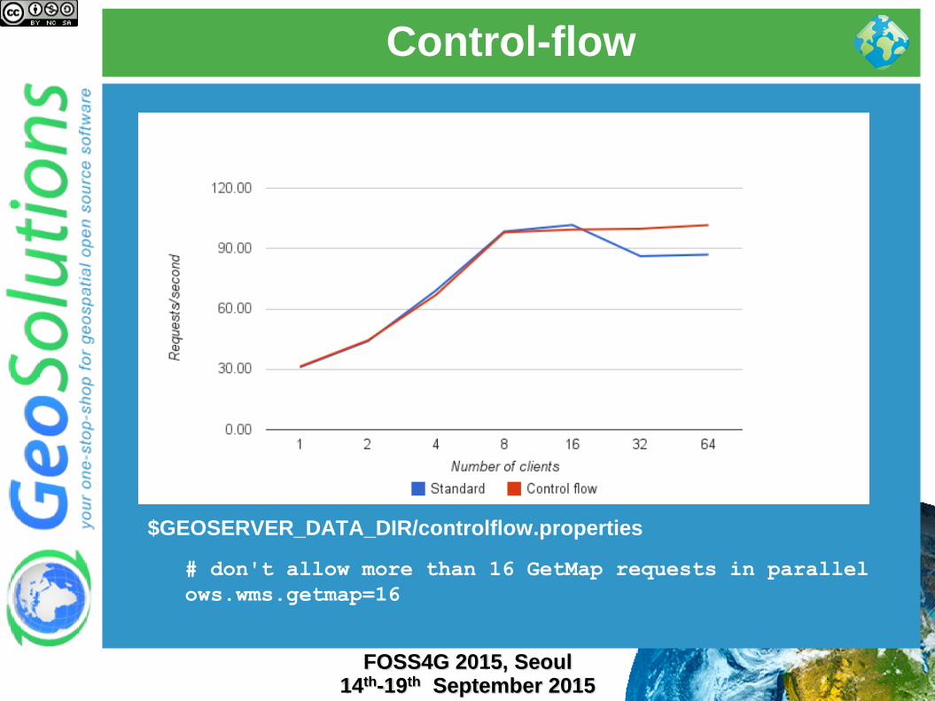
$GEOSERVER_DATA_DIR/controlflow.properties
# don't allow more than 16 GetMap requests in parallel
ows.wms.getmap=16

JVM and deploy configuration
FOSS4G 2015, Seoul 14th-19th September 2015

Premise
FOSS4G 2015, Seoul 14th-19th September 2015
There is no “GO FAST!” option in the Java
Virtual Machine
The options discussed here are not going to
help if you did not prepare the data and the
styles
They are finishing touches that can get
performance up once the major data
bottlenecks have been dealt with
Check “Running in production” instructions
here

JVM settings
FOSS4G 2015, Seoul 14th-19th September 2015
--server: enables the server JIT compiler
--Xms2048m -Xmx2048m: sets the JVM use
two gigabytes of memory
--XX:+UseParallelOldGC -
XX:+UserParallelGC: enables multi-threaded
garbage collections, useful if you have more
than two cores
--XX:NewRatio=2: informs the JVM there will
be a high number of short lived objects
--XX:+AggressiveOpt: enable experimental
optimizations that will be defaults in future
versions of the JVM

Raster subsystem configuration
FOSS4G 2015, Seoul 14th-19th September 2015
Install the TurboJPEG extension
Enable JAI Mosaicking native
acceleration
Give JAI enough memory
Don’t raise JAI memory
Threshold too high
Rule of thumb: use 2 X #Core
Tile Threads (check next slide)
Play with tile Recycling against
your workflows (might help,
might not)

Marlin renderer
FOSS4G 2015, Seoul 14th-19th September 2015
The OpenJDK Java2D renderer scales up, but it’s not
super-fast when the load is small (1 request at a time)
The Oracle JDK Java2D renderer is fast for the single
request, but does not scale up
Marlin-renderer to the rescue:
https://github.com/bourgesl/marlin-renderer
Being considered
for merging in
OpenJDK (9 or 10)
Upgrade!
FOSS4G 2015, Seoul 14th-19th September 2015
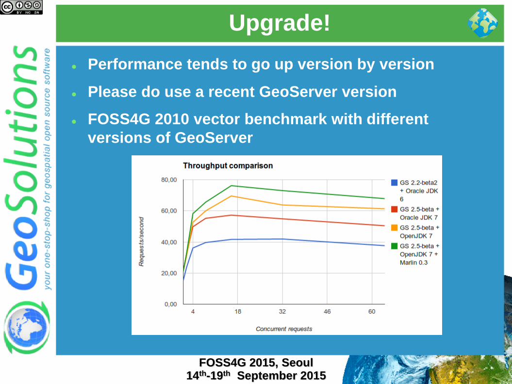
Performance tends to go up version by version
Please do use a recent GeoServer version
FOSS4G 2010 vector benchmark with different
versions of GeoServer


