
DOPPLER RADAR OBSERVATIONS AND
ENSEMBLE-BASED DATA ASSIMILATION FOR
CLOUD-RESOLVING HURRICANE PREDICTION
Fuqing Zhang
Penn State University
Contributors: Yonghui Weng, Jason Sippel, Zhiyong Meng, Craig Bishop,
John Gamache and Frank Marks
Acknowledgements: Support from NSF, ONR, NOAA, TCEQ and TACC

Ensemble forecast provides better, flow-dependent estimate of background error covariance: B = Ne
-1 (xif-x)(xi
f-x)T
obs y x1
f
EnKF Ensemble forecast
xNf
t=t0 t=t0+ t
x1a
xNa
x1f
xNf
xa = xf + BHT(HBHT+R) -1(y-Hxf)
Equivalence to 4Dvar in linear systems; no adjoint or TLM;
fully coupled with ensemble forecast; nonlinear dynamics
included; adaptable to be coupled/hybrid with 3D/4DVar
Ensemble Kalman Filter for Mesoscales (Evensen 1994 JGR; Zhang and Snyder 2007 BAMS)

A Simple Example
T = T1 + K (T2-T1); K = 1 2/( 1
2+ 22)
If T1 is the background state with std of 1 ; T2 is the observation with std of
2 , then the posterior analysis T and its std will be:
2 = 1 2
22 /( 1
2+ 22)
or T = [ 2 2/( 1
2+ 22)] T1 + [ 1
2/( 12+ 2
2)]T2
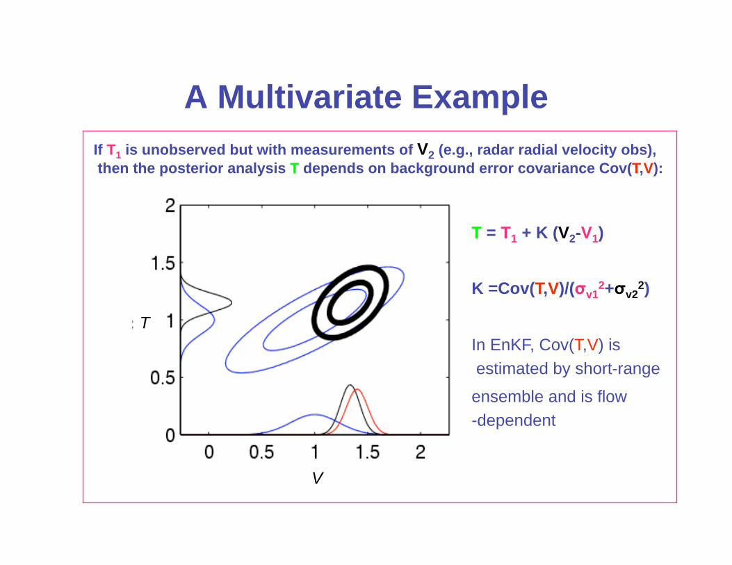
A Multivariate Example
V
T
T, V T
T = T1 + K (V2-V1)
K =Cov(T,V)/( v12+ v2
2)
In EnKF, Cov(T,V) is
estimated by short-range
ensemble and is flow
-dependent
If T1 is unobserved but with measurements of V2 (e.g., radar radial velocity obs),
then the posterior analysis T depends on background error covariance Cov(T,V):

Vertical velocity at 5km (colored) and surface cold pool (black lines, every 2K)
Observations: radial velocity Vr only, available every 5 minutes where reflectivity Z>12dBZ
(Snyder and Zhang 2003 MWR; Zhang et al. 2004 MWR; Dowell, Zhang et al. 2004 MWR)
Assimilation of Doppler Radar Observations
Truth
EnKF
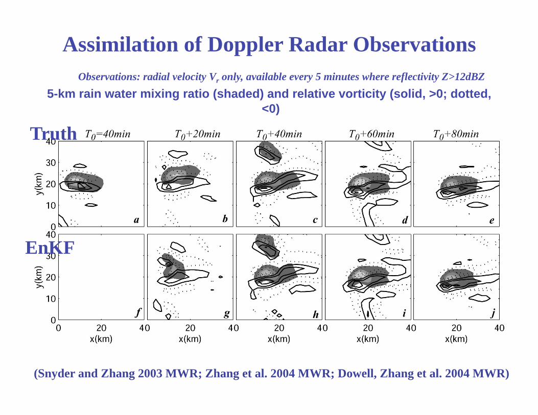
5-km rain water mixing ratio (shaded) and relative vorticity (solid, >0; dotted,
<0)
(Snyder and Zhang 2003 MWR; Zhang et al. 2004 MWR; Dowell, Zhang et al. 2004 MWR)
Truth
EnKF
Observations: radial velocity Vr only, available every 5 minutes where reflectivity Z>12dBZ
Assimilation of Doppler Radar Observations
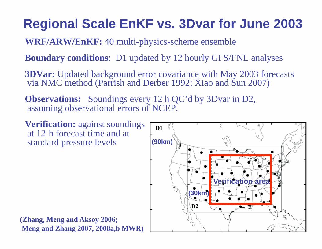
WRF/ARW/EnKF: 40 multi-physics-scheme ensemble
Boundary conditions: D1 updated by 12 hourly GFS/FNL analyses
3DVar: Updated background error covariance with May 2003 forecasts via NMC method (Parrish and Derber 1992; Xiao and Sun 2007)
Observations: Soundings every 12 h QC’d by 3Dvar in D2, assuming observational errors of NCEP.
Verification: against soundings at 12-h forecast time and at standard standard pressure levels
(Zhang, Meng and Aksoy 2006;
Meng and Zhang 2007, 2008a,b MWR)
Regional Scale EnKF vs. 3Dvar for June 2003
Verification area
(30km)
(90km)

EnKF vs. 3DVar: WRF/ARW 12h forecast RMSE for Jun’03
---EnKF --- 3DVar_WRF
EnKF performs generally better than WRF 3DVar for the whole month of June
(Meng and Zhang 2008b MWR)
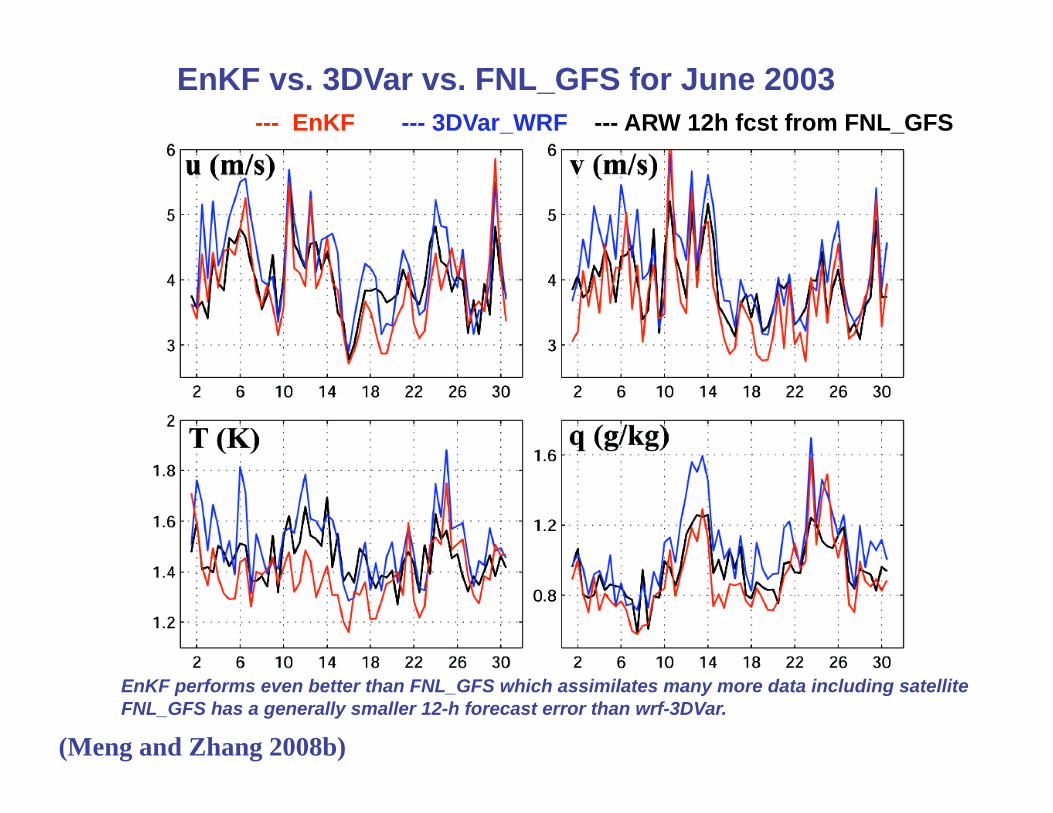
--- EnKF --- 3DVar_WRF --- ARW 12h fcst from FNL_GFS
EnKF vs. 3DVar vs. FNL_GFS for June 2003
EnKF performs even better than FNL_GFS which assimilates many more data including satellite
FNL_GFS has a generally smaller 12-h forecast error than wrf-3DVar.
(Meng and Zhang 2008b)

Vertical Distribution of 12-h Forecast RMSE for June 2003
--- EnKF --- 3DVar_WRF
Wind amplitude (m/s) T(K) q (g/kg)
EnKF performs clearly better than WRF-3DVar in almost every vertical level
(Meng and Zhang 2008b)

• EnKF has significantly smaller overall 12-h forecast error than both WRF-3DVar and FNL_GFS.
• FNL_GFS has smaller overall forecast error than WRF-3DVar.
Monthly Averaged 12-h-Forecast RM-DTE for June 2003
(Meng and Zhang 2008b)

Monthly Averaged Forecast Error at Different Lead times
initialized from respective analyses (every 12h, 60 samples) —FNL_GFS —EnKF —3DVar_WRF
(Meng and Zhang 2008b)

Cases with WSR88D or NOAA P3 airborne Vr OBS
Assimilation of Doppler Vr OBS for Hurricanes Emily, Katrina, Rita’05, Humberto’07, Dolly, Fay, Gustav, Ike’08
• TC initialization is intrinsically multiscale; initial vortex and convective details can both be important for intensity, structure and precipitation forecasts
• Abundant WSR-88D obs for TCs near coasts
• HRD collects NOAA P3 aircraft radar data sets and process them on most tropical cyclones since 1994.
• NOAA airborne Doppler missions to expand for TCs

Coastal Storms within WSR-88D: Hurricane Humberto (2007)
Synopsis: first lanfalling hurricane at
US coast since busy 2005 season; fastest
from first NHC warning to a category 1
hurricane; 70 million estimated property
damage, 1 death
MSLP
GFS (blue) & 4.5-km WRF (red) forecast: No
forecast initialized with GFS FNL analysis ev 6hr
from 00Z 12 to 00Z 13 predicts rapid formation
It becomes a hurricane 14hr after this NHC forecast.
(Zhang et al. 2008, MWR, in review)

KCRP
KHGX
KLCH
• WRF domains: D1-D2-D3-D4 grid sizes---40.5, 13.5, 4.5, 1.5km (movable)
– Physics: WSM 6-class microphysics; YSU PBL; Grell-Devenyi CPS
• EnKF (Evensen 1994; Meng & Zhang 2008a,b): - 30-member ensemble
- Initialized at 00Z 12 using 3DVar background uncertainty with FNL analysis; GFS forecast used for boundary condition in forecasts
- Advantage: flow-dependent background error covariance from ensemble; flow dependent analysis uncertainty for ensemble forecasting
• Data assimilated: – WSR88D at KCRP, KHGX
and KLCH radar radial
velocity every hour from
09Z to 21Z 12 Sept 2007
- Data assimilation are performed
for all domains; obs err 3m/s
Assimilate W88D Vr for Humberto with EnKF
D1

Super-Obs: QC and thinning of WSR-88D Vr Obs
•Define SO position depended on the radial distance
•Average10 nearest data points in the raw polar scan to create a SO
•Averaging bin is 5km max radial range and 5° max azimuthally resolution
•There are at least 4 valid velocity data within an averaging bin.
•The standard deviation checking of the velocities.
0.5degree RAW data 0.5degree SO

Assimilate WSR88D Vr Obs: Number of SOs
D1
Super-Ob of KCRP and KHGX at 09Z/12
Number of Assimilated SOs
-WRF/EnKF starts assimilating hourly Vr obs of CRP, HGX and LCH WSR88D
radars from 09Z/12 to 21Z/12 after a 9-h ensemble forecast from GFS/FNL analysis
-Successive covariance localization with different ROIs for different subset of SOs
0
500
1000
1500
2000
2500
3000
09Z12 12Z12 15Z12 18Z12 21Z12 00Z13 03Z13 06Z13
nu
m
KLCH
KCRP
KHGX

CNTL EnKF Analysis vs. KHGX Obs vs. NoDA KHGX base Vr EnKF Analysis Mean Pure EF Mean w/o EnKF
09Z/12
18Z/12
03Z/13

Forecast initialized with EnKF Assimilating WSR88D Vr
Min SLP Max wind
WRF single forecasts initialized with EnKF analysis at 18Z or 21Z September
12 captures well the rapid TC formation and deepening (red and brown)
MinSLP (hPa) MaxWSP (m/s)

Forecast from EnKF Analysis at 18Z/12 Obs dBZ forecast with EnKF Pure EF Mean w/o EnKF
3h at 21Z/12
9h at 03Z/13
15h at 09Z/13
(a) (b) (c)
(d) (e) (f)
(g) (h) (i)

Comparison with WRF/3DVAR Assimilating the Same OBS
Min SLP Max wind
Without flow-dependent background error covariance, WRF/3DVAR forecast
failed to develop the storm despite fit to the best-track obs better at 18Z

Predictability: 1.5-km (left) vs. 4.5-km (right) 42h ensembles
MinSLP
MaxWSP
4.5-km 1.5-km

WRF/EnKF for Katrina with W88D Data
160x 120 x 40.5km
253x 253 x 13.5km
262x253x4.5km
• WRF domains D1-D3: 40.5, 13.5, 4.5 km ; 35 vertical levels; WSM 6-class microphysics; YSU PBL; Grell-Devenyi CPS
• EnKF (Meng & Zhang 2008a,b) but with 30-member single-scheme ensemble; Gaspairi&Cohn 99' covariance localization but with varying RoI
• IC & BC: FNL analysis using 3DVAR background uncertainty
• Data assimilated:
– TC position (err=20km)
and intensity (err=1hpa) D1,D2
every 3 h from 0Z/25 to 0Z/26
(Chen and Snyder 2007)
– Doppler velocity (err=3m/s)
from KMAX and KBYX (D1, D2)
at 00Z/26 and/or 03 & 06Z
• Forecast: 96-h single run from mean
analysis with D1, D2, D3 (two-way)
w/ D3 movable 160x 120 x 40.5km
253x 253 x 13.5km
262x253x4.5km
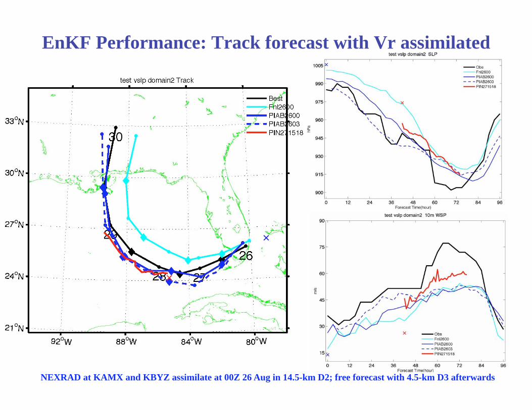
EnKF Performance: Track forecast with Vr assimilated
NEXRAD at KAMX and KBYZ assimilate at 00Z 26 Aug in 14.5-km D2; free forecast with 4.5-km D3 afterwards

Airborne Doppler Radar Scanning Geometry

Hurricane Rita (2005): Best track and
NOAA P3 Airborne Missions

15:55:56’
1.50 degree
elevation
All SOs
1.5° SOs
Airborne Vr Super-Observations (SOs):
Similar to W88D but more QCs

Forecasts from EnKF with Airborne vs. NEXRAD
WRFGFS-2100: WRF deterministic
forecast took GFS 0000UTC Sep21
analysis as IC and its forecast as BC;
Airborne-20: WRF DF from the EnKF
analysis at 1800UTC Sep20 which
assimilated N43 Vr at 1600, 1730 and
1800UTC Sep20;
KBYX-20: WRF DF from the EnKF
analysis at 1800UTC Sep20 which
assimilated KBYX Vr at 1600, 1700
and 1800Z Sep20.
Min SLP Max 10m WSP
track

Impacts of Airborne Vr EnKF for Katrina (2005)
Min SLP (hPa)
Max 10m WSP (m/s) Track

4.5-km (top, 126h) vs. 1.5-km (bottom, 102h) ensemble fcsts
MinSLP MaxWSP
4.5-km
1.5-km

Hurricane Emily (2005):
WRF/ARW Forecasts
from GFS vs. EnKF
Min SLP (hPa)
MaxWSP (m/s)
track

TOWARDS REALTIME ASSIMILATION OF
DOPPLER RADAR OBSERVATIONS FOR CLOUD
-RESOLVING HURRICANE PREDICTION
Dolly, Fay, Gustav, Ike’08
Thanks to John Gamache, our Vr superobbing procedure is now implemented on P3 in realtime
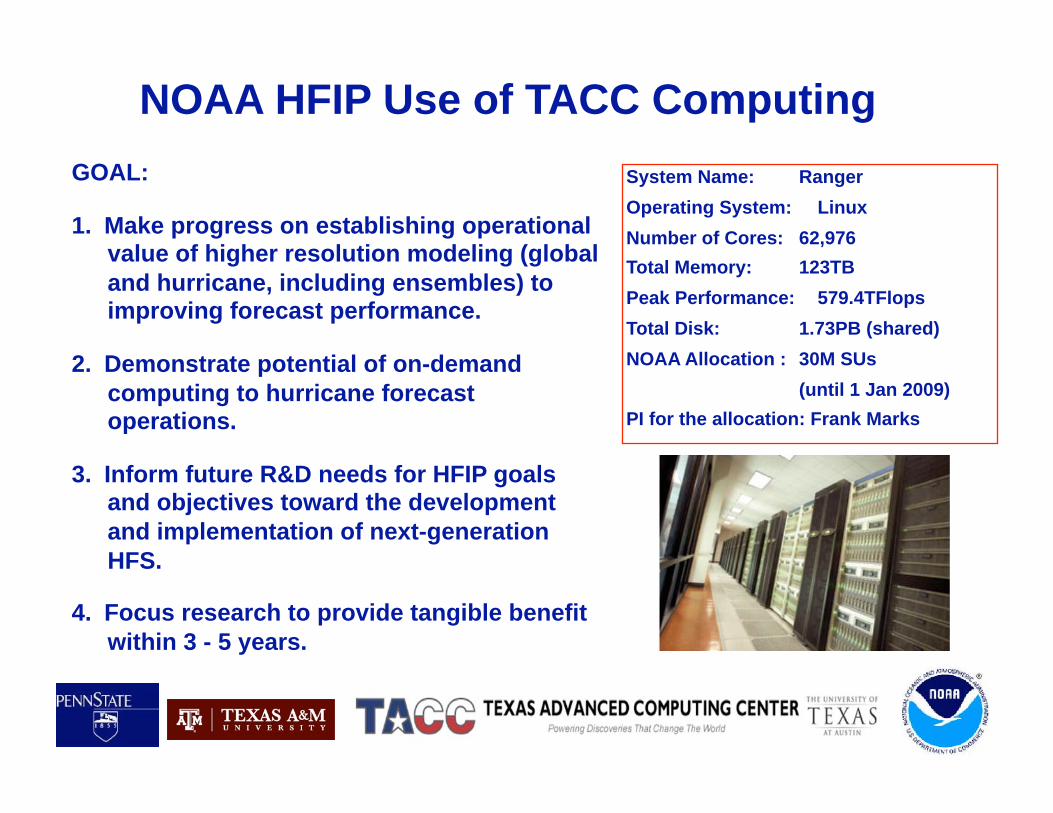
NOAA HFIP Use of TACC Computing
System Name: Ranger
Operating System: Linux
Number of Cores: 62,976
Total Memory: 123TB
Peak Performance: 579.4TFlops
Total Disk: 1.73PB (shared)
NOAA Allocation : 30M SUs
(until 1 Jan 2009)
PI for the allocation: Frank Marks
GOAL:
1. Make progress on establishing operational value of higher resolution modeling (global
and hurricane, including ensembles) to improving forecast performance.
2. Demonstrate potential of on-demand
computing to hurricane forecast operations.
3. Inform future R&D needs for HFIP goals and objectives toward the development
and implementation of next-generation
HFS.
4. Focus research to provide tangible benefit
within 3 - 5 years.

HFIP-TACC On-demand Test • Diverse NOAA (HRD, ESRL, NCEP/NHC, NCO, EMC)
and university (PSU, TAMU, TACC) team established on-demand capability to support operational hurricane forecasting.
• Built upon HFIP high-resolution test plan to use high resolution global (FIM at 15-km) and regional (ARW at 1.5-km using EnKF to assimilate Doppler radar superobs) models to demonstrate on-demand capability.
• NCEP model fields and Doppler radar superobs from NOAA P-3 aircraft flow automatically to TACC, research models run, output products generated for forecasters, and products transferred to NHC via NCO.
• Portions of process tested during Dolly and Fay, with a test of complete system during Gustav and Ike.

Towards Real-time Assimilation of
Airborne Radar Observations with EnKF:
Same Experimental Design as Test Cases WRF/ARW triply-nested domains for both EnKF analyses and free forecasts:
D1: 121x160x40.5km x 35 levels (similar to GFDL coarse domain)
D2: 121x160x13.5km x 35 levels
D3: 253x253x 4.5km x 35 levels (moving nest in forecast mode)
Time performance of standard real-time WRF/ARW forecast initialized with GFS
Waiting time for GFS completion: 4.5 h
Transfer GFS analysis and forecasts from NCEP to TACC: 0.3 h
Initialization of WRF/ARW with GFS using WPS: 0.4 h
126-h WRF free forecast with 512 processors: 2.7 h
Total time lapse: 7.9 h (3.4 h after GFS completion, 1.5 km is 7 h after)
Estimated real-time WRF/ARW forecast initialized assimilating airborne Vr data
EnKF ensemble initialized with most recent available GFS: no waiting time
Quality control and super-observation (SO) of Airborne data per hour: 0.3h
Transfer airborne ~3000 SOs from P3 to TACC: 0.2 h
EnKF assimilation of 1-h SOs: 0.5 h
126-h WRF free forecast with 512 processors: 2.7 h
Total time lapse: 3.7 h (1.5-km is 7 h) after Doppler observations taken

Near-realtime Tests of Hurricane Dolly (2008) SOs Generated shortly after P3 mission

Performance of Airborne Vr
Assimilation for Dolly (2008)
Min SLP
Max 10m WSP
track
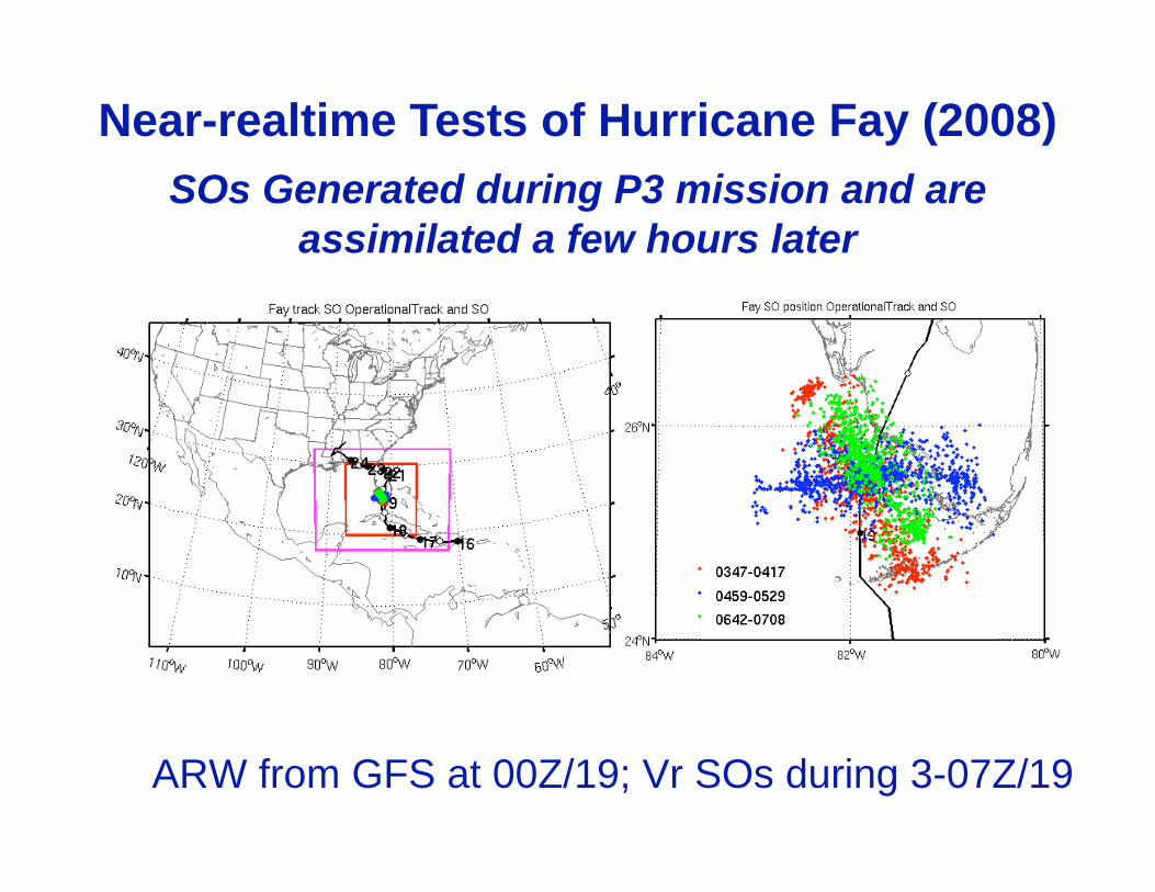
Near-realtime Tests of Hurricane Fay (2008)
SOs Generated during P3 mission and are
assimilated a few hours later
ARW from GFS at 00Z/19; Vr SOs during 3-07Z/19

Max 10-m WSP Track
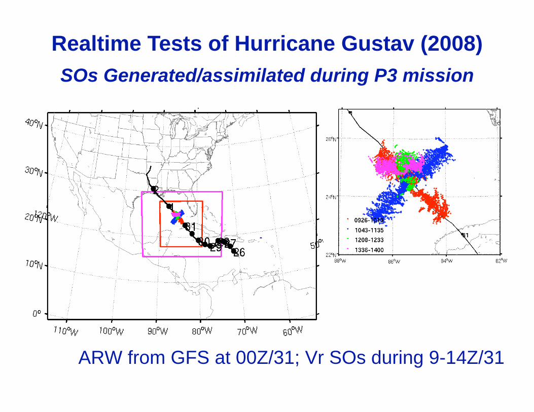
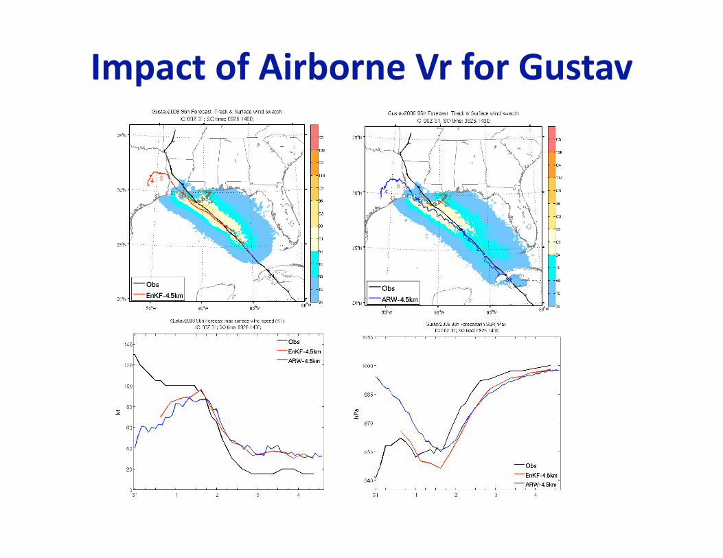
ARW from GFS at 00Z/31; Vr SOs during 9-14Z/31
Realtime Tests of Hurricane Gustav (2008)
SOs Generated/assimilated during P3 mission

Realtime Tests of Hurricane Ike (2008)
SOs Generated/assimilated during P3 mission
ARW from GFS at 12Z/9; Vr SOs during 21-24Z/09

Realtime ARW Performance with Vr EnKF
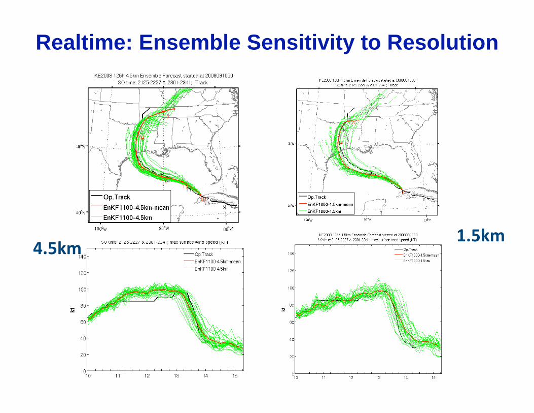
Realtime: Ensemble Sensitivity to Resolution

Concluding Remarks • EnKF assimilation with both the ground-based and
airborne radar observations into cloud-resolving mesoscale models is promising for initializing hurricanes near observed intensity and for subsequent forecast
• The impacts of airborne Vr are similar to WSR-88D Vr
• EnKF combines data assimilation and ensemble forecast that provides flow-dependent analysis/forecast uncertainty
• Real-time, on-demand, convective-resolving ensemble analysis and forecast experiments on NSF HPC facility assimilating airborne Doppler observations shows great promises for the future of hurricane prediction
• WRF/ARW forecasts are surprisingly similar for the 4.5-km and 1.5-km grid spacings; 4.5-km grid very practical

Experimental Design Using EnKF to
Assimilate Airborne Radar Observations:
Towards Potential Real-time Applications


