
FLOOD, JONATHAN M., M.A. Water Management in Neopalatial Crete and the Development of the Mediterranean Climate. (2012) Directed by Dr. Michael E. Lewis. 122 pp. This study analyzes patterns of behavioral response to environmental stimuli
recovered in the archaeological record in order to make inferences about the climatic
conditions driving the response. In the years between 1700 and 1450 BCE, the people
living on the island of Crete erected dams, dug wells, hung gutters, integrated water ritual
into their socio-cultural fabric, utilized ceramic mulches to conserve soil moisture, and
terraced hillsides. None of these water-centric behaviors existed on the island prior to this
period, and Minoan civilization rapidly deteriorated directly afterwards. Conventional
paleoenvironmental proxy datasets (palynological, geomorphological, isotopic, etc.) do
not offer insights into the climatic conditions on Crete during this pivotal, final period.
This study utilizes methods developed in a branch of geography known as hazard
research and applies these methods to the available data concerning Minoan water
management for the Neopalatial period. Hazard research methodology allowed for eight
characteristics of the Neopalatial drying of Crete to be elucidated, they include: 1) the
aerial extent of the event, 2) its magnitude, 3) frequency, 4) duration, 5) the speed of its
onset, 6) the spatial dispersion of the event, 7) the temporal spacing (periodicity), and 8)
the time the event began. This paper demonstrates that human behaviors recovered as
material culture in the archaeological record can be used to make detailed inferences
about the climatic conditions at the time of their creation.
WATER MANAGEMENT IN NEOPALATIAL CRETE
AND THE DEVELOPMENT OF THE
MEDITERRANEAN CLIMATE
by
Jonathan M. Flood
A Thesis Submitted to the Faculty of The Graduate School at
The University of North Carolina at Greensboro in Partial Fulfillment
of the Requirements for the Degree Master of Arts
Greensboro 2012
Approved by
______________________________________
Committee Chair

ii
APPROVAL PAGE
This thesis has been approved by the following committee of the Faculty of The
Graduate School at The University of North Carolina at Greensboro.
Committee Chair __________________________________________
Committee Members __________________________________________
__________________________________________
____________________________ Date of Acceptance by Committee ____________________________ Date of Final Oral Examination
iii
TABLE OF CONTENTS
Page
LIST OF TABLES……………………………………………………………………..... iv LIST OF FIGURES .…………………………………………………………………...... v CHAPTER I. INTRODUCTION .................................................................................................1 II. PHYSIOGRAPHY OF CRETE.............................................................................8 III. WATER AND TEMPERATURES .....................................................................11 IV. GEOLOGIC HISTORY OF CRETE...................................................................14 V. THE ANATOMY OF DROUGHT......................................................................24 VI. HYDROGEOLOGY AT PALAIKASTRO.........................................................29
VII. THE GEOGRAPHIC DISTRIBUTION OF WATER MANAGEMENT FEATURES AND SITES ..................................................46
VIII. UNDERSTANDING ANCIENT RESPONSE TO ENVIRONMENTAL HAZARD THROUGH ETHNOGRAPHIC ANALOGY......................................................................59 IX. MINOAN RESPONSE TO DROUGHT HAZARD ...........................................83
X. THE PSEIRAN DAMS: MINOAN GEOLOGISTSAND HYDRAULIC ENGINEERS ...................................................................................................91
XI. MINOAN WATER RITUALDURING THE NEOPALATIAL PERIOD .........................................................................................................103
XII. CONCLUSIONS ...............................................................................................107 REFERENCES ................................................................................................................110

iv
LIST OF TABLES
Page
Table 1. Scales of Environmental Variation………………………………………….... 61 Table 2. Models for Scale Changes in Ecosystems……………………………………. 61 Table 3. Short-term vs. Long-term Responses to Water Deficits……….……………... 67 Table 4. Minoan Responses to Drought, Short-term vs. Long-term Stimuli…………………………………………... 84

v
LIST OF FIGURES
Page
Figure 1. The Neopalatial sites on Crete ...……………………………………………. 30 Figure 2. Geological Map of Crete, Eastern Section, 1:50,000 ...………….………..... 31 Figure 3. Plan View of Palaikastro …...…………………………………………...….. 35 Figure 4. Profile of Well 576 at Palaikastro ...………………………………............... 36 Figure 5. Time Series of Tree Ring Growth for the Modern Period ...……………....... 41 Figure 6. Reconstructed Precipitation Rates for Central Turkey Based on Tree Ring Data .……………………………………………….... 42 Figure 7. The Neopalatial Sites .....…….…………………………………………….... 46 Figure 8. Neopalatial Sites with Water Management Features ...……………………... 51 Figure 9. Topographic Map of Pseira with Archaeological Features marked and numbered .....………………………………………………..... 93 Figure 10. Dam and Channel Network at Choiromandres ...…………………………... 98 Figure 11. Water Ritual Area in Building B2 on Mochlos ...……………………….... 104 Figure 12. Water Genii Seal Stone Impressions ...………………………………….... 106

1
CHAPTER I
INTRODUCTION
This study investigates the nature of the environmental disruption that inspired the
water management features present in the archaeological record for the Neopalatial
Period on Crete (1700-1450 BCE). Waterworks such as gutters, wells, dams, and cisterns
numbered few, if any, on Crete prior to the Neopalatial Period and most were installed in
the latter two-thirds of this period, in the so-called Late Minoan IA and IB sub-periods
(1570-1510, 1509-1450 BCE respectively). A single water-well emplaced into the
Kaphala Hill near Knossos sometime during the Early Minoan Period (Hood, 1966) is the
only known noteworthy exception to the Neopalatial water management phenomenon.
Attempts to explain why the management of freshwater became increasingly important
on Crete during the Late Minoan I Period (henceforth LM I) have been suggested by
several Minoan archaeologists (Betancourt, 2005) (MacGillivray et al, 2007). Phillip
Betancourt (2005, 291) suggests that the new water challenges of the LM I were a result
of either a change in climate, a growth in population, or other causes unknown to modern
scholarship. MacGillivray, Sackett, and Driessen (2007, 224) interpret the waterworks of
the LM I as societal adaptations to an episode of climatic instability that affected much of
the eastern Mediterranean during this time and was manifest on Crete as major drought.
MacGillivray and his colleagues link the LM I drought with violence and tumult apparent
in the archaeological record at the close of the LM I period on Crete, and also cite unrest

2
in Egypt and the Levant during this time to support their position (2007, 224).
Paleoenvironmental studies conducted around the Mediterranean basin offer an
alternative, less spectacular interpretation of the Neopalatial drying phenomenon. A.T.
Grove (2001), O. Rackham (1996), J. Moody (1997), S. Bottema (1980), L. Hempel
(1990), H. Bolle (2003), S. Harrison (1993), and G. A. Goodfriend (1991) suggest that
the antipodal distribution of annual rainfall—wet winters followed by droughty
summers—that now characterizes Mediterranean climate developed sometime during the
Aegean Bronze Age for this interglacial. Estimated dates for the onset of summer dry-
season/winter wet-season dichotomy range widely among scholars. After synthesizing
nine botanical and sediment studies from Crete, Croatia and mainland Greece, Ludwig
Hempel placed the initial development of the Mediterranean summer dry-season
sometime between 4800 to 2400 BC, with a concentration around 3400 BC (1990).
Harrison and Digerfeldt (1993, 233) place the arrival of the summer dry-season in the
Mediterranean sometime between 4000 to 3000 BC, citing attenuated lake levels in
Greece, Spain and Portugal during this interval of time. Sclerochronological studies
carried out by Goodfriend (1991, 424) indicate that the summer dry-season developed
around 3500 years ago in Israel, which is coincident with the Late Minoan Period on
Crete. Rackham and Moody (1996, 39) suggest that the change to a ‘Mediterranean’
climate on Crete occurred gradually over the Bronze Age, but was completed by the
middle of the second millennium BC, concurrent with the LM I period in Minoan
chronology. Thus, two working hypotheses, not necessarily mutually exclusive of the
other, might explain the sudden occurrence of water management features in the
3
archaeological record for the Neopalatial Period. The LM I waterworks could be the
vestiges of an acute drought that befell the island and induced dismay throughout the
eastern Mediterranean as some archaeologists suggest (MacGillivray et al, 2007). Or
perhaps the water management features evident in the LM I simply mark the arrival of
the Mediterranean summer dry-season to Crete.
This study examines the Neopalatial water management features within their
respective environmental and social contexts to better understand the nature of the event
that inspired their creation. Unraveling the spatial and temporal details of the changing
climatic conditions on Crete during the Neopalatial period, specifically the intensification
of annual summer drought, allows for a more accurate interpretation of the cultural
change that took place at the conclusion of the LM I period, which ended in the collapse
of Minoan civilization and the Mycenaean occupation of the island. This study, however,
simply explores two possible climatic scenarios that might account for the increased need
for freshwater management in the Neopalatial period and does not go into detail linking
those scenarios to conflict. The goal of this study is to demonstrate the effectiveness of
using specific elements of the archaeological record as proxies for understanding past
climatic conditions. This goal is dynamically bidirectional, meaning that the deeper the
understanding of the environmental context past human groups developed or simply
existed in, the deeper the understanding of the preserved cultural behaviors, the
archaeology. This dynamic link is between culture and environment is particularly strong
and the inferences particularly fruitful when the obvious function of an artifact is to
mitigate some environmental variable, such as water deficiency. Realizing that certain
4
elements of the archaeological record are brief but cogent chronicles of human ecology
furthers our general understanding of the adaptive capability of human groups to an array
of changing environments. Continuing to develop an archive of successful and
unsuccessful cultural adaptations to environmental variables could provide an essential
rubric for future environmental decisions. Moreover, a better understanding of climate
change in detail for specific regions, eastern Crete in this study, provides a roadmap to
the range of future environmental changes that an area might experience.
This study is organized to provide the essential environmental and social
background information before discussing the Neopalatial water management
phenomenon and its probable causes. The present physiography of the island will be
discussed in terms of geology, climate, hydrology, soils, and vegetation. Then the
paleoenvironmental information available for Crete and other areas around the Eastern
Mediterranean relevant to this study will be presented. The paleoenvironmental section
covers the development climate and vegetation in the Aegean since end of the Pleistocene
(ca. 10,000 BC) but primarily focuses on specific conditions that developed during the
middle to late Holocene epoch, specifically time of the Aegean Bronze Age (ca. 3300-
1100 BC). The paleoenvironmental background section is included to chart the
development of today’s Mediterranean climate, which may have stimulated the flurry of
waterworks undertaken in Neopalatial Crete. After the study area is thoroughly
introduced, information concerning the nature of drought as an environmental
phenomenon is discussed. This section of the study outlines the sequential development
of drought and the patterned effects on the natural and cultural environment. The drought

5
section also includes the introduction and explanation of a theoretical model developed to
categorize societal adaptations to drought in terms of the duration and perceived
periodicity of drought events. The model is assembled using ethnographic examples and
principles borrowed from a school of geographic analysis known as hazard research
(White, 1974). It is important to remember that the specific components that make up the
model reflect the overall goal of this study. In other words, the model uses the design and
functional characteristics of Minoan water management features to understand whether
the waterworks reflect an episode of acute drought (short-term reactive responses) or the
arrival of the Mediterranean summer-winter rainfall contrast (long-term adaptive
responses). The drought adaptation model does not include other cultural or
environmental scenarios that may have played a role in the Neopalatial water
management phenomenon, such as rapid population growth or technological innovations.
Once the background, theoretical, and methodological information is introduced
to the reader, the known water management features of the Neopalatial period are
enumerated and inspected in terms of their design and functional properties. The
objective of this section is to use Neopalatial water management features to understand
eight characteristics of the climatic event that triggered their introduction and integration
into Minoan life. The eight characteristics include 1) the aerial extent of the event, 2) its
magnitude, 3) frequency, 4) duration, 5) the speed of its onset, 6) the spatial dispersion of
the event, 7) the temporal spacing (periodicity), and 8) the time the event began. These
eight factors provide more than enough information about the Neopalatial drying episode
to discern whether the event was a short lived, intense drought or the arrival of the xeric
6
or ‘Mediterranean’ climate to Crete. The analysis begins by charting the geographic
distribution of water management features on the island in order to understand the areal
extent and spatial dispersion (1 and 6) of the LM I water deficiency. This section also
provides an introduction to and explanation of the types of water management features
recognized in this study. Patterns in the spatial distribution of Minoan water features are
then compared to the past and present hydrologic and climatic patterns covered in the
background section of the study. Then the hydrogeological context of several Minoan
wells will be examined in order to decipher the magnitude and duration of the Neopalatial
drought event, or perhaps series of events (2 and 4). The typology of the ceramic artifacts
discovered in the lower most levels of the Minoan wells allude to the original date of
construction and thus to the time of the events onset (8). The quantity of ceramic vessels
in that lowermost level serves as a testament to the duration of the well’s use, which can
in turn be used as a proxy to understand the duration of the drought event (4). The design
and functional characteristics of the Minoan irrigation network documented at two sites
indicate the speed of the drought’s onset (5) and also the perceived periodicity of drought
(7). Because frequency (3) is the most definitive variable in explaining whether
Neopalatial water management was inspired by the arrival of the Mediterranean climate
or by a short-lived drought, this variable is explained in more detail than the other seven.
The rate at which drought occurred or was repeated during the Neopalatial is discerned
by comparing the actual Minoan responses to drought with a model outlining long and
short-term adjustments to drought gathered from ethnographic and historic sources. The
fifteen possible Minoan adjustments to drought identified in this study are then organized

7
within the model under either the long or short-term columns. The study concludes with a
reiteration of the paleoenvironmental data for the Eastern Mediterranean and integration
of the climatic information recovered from the Neopalatial water management features in
this study.

8
CHAPTER II
PHYSIOGRAPHY OF CRETE
The main island of Crete measures 245 km long and ranges from 12 to 52 km in width.
Excluding the thirty-four offshore islets that girt the main island, Crete has a surface area
of roughly 8,620 square kilometers (Morris, 2002). This makes Crete the fifth largest of
all the islands rising from the Mediterranean Sea. For a stateside analog, Crete is roughly
the same width, length, and area as Long Island, NY. The long, slender island lies
between 23°30’ and 26°20’ east longitude and 34°54’40” and 35°41’34” north latitude
and forms the keystone in the Hellenic island arc, which is further discussed in the
geology section. Crete is a precipitous place with a topography dominated by four
mountain ranges. From west to east they are the Lefka Ori (White Mountains), Psiloritis
(Ida), Lasithi (Dikte), and Siteia Ranges. The Lefka Ori is the grandest range on Crete.
The aptly named White Mountains are home to at least 20 peaks over 2,200 m, 100 sq.
km above the tree-limit, seventeen major gorges, and its own unique landscape of
Mediterranean High Desert (Rackham and Moody, 1996). As a unit, the Lefka Ori are
dominant, but Crete’s single tallest peak rises from the mountain range just to the east of
the mighty White Mountains. The great snow-crusted horn of Mount Ida rises from the
Psiloritis Range and commands the most complete view of the southern Aegean world.
At a height of 2,456 m, Ida is not only the tallest mountain on Crete; it is also the highest
point in the southern Aegean, Cretan and Libyan Seas. The towering summit of Ida,

9
Timios Stavros, is always the first portion of Crete seen when sailing in from northern,
southern or eastern ports of call. The lofty beacon of Timios Stavros has likely served
sailors since antiquity and perhaps before. Ida’s prominence not only attracts sailors, it
also seems to summon snow. Mount Ida is the only mountain in the southern
Mediterranean islands where moraines, cirques, and roches moutonnées have been
identified (Rackham and Moody, 1996, p.14). These types of geomorphic features are
common in alpine environments of Central Europe but are an oddity in the southern
Mediterranean. East of the Psiloritis Range, the mountains fall to plains before rising
again to form the Lasithi massif. It is between the two ranges that you find the capital of
Crete today, Herakleion, and the ruins of the ancient capital, the palace of Knossos. The
mountains of the Lasithi range are smaller in areal extent and lower in elevation than
those in the White or Idaean ranges. Despite their smaller size, the Lasithi Mountains
harbor one large, flat surprise. The most expansive and contiguous flat area on the island
is located within the range, the Lasithi Plain. The face of the plain lies at about 800
meters above sea level, which is higher than many of the peaks that rise in the eastern
third of the island. The Lasithi Plain boasts a peculiar and long settlement history that
extends nearly uninterrupted for 5,000 years (Watrous, 1982). The peaks of the Lasithi
and the easternmost mountains are separated by one massive normal-faulted block called
the Ierapetra Graben. This sinking mass of rock has done much to hollow out one of the
islands largest and busiest bays, the Gulf of Mirabello. The graben has also configured
the island in such a way that the eastern third of the island is geographically segregated
from the central and western parts of Crete. The western face of the Siteia Mountains rise
10
sharply from the Ierapetra Plain to create a wall of rock that only falls away at its
southern extreme near the south coast. Several streams have etched slender v-shape
breaks in the range’s western face; these narrow gorges can be perilous places. The Siteia
Mountains are smaller, lower, and dryer than the other three ranges. Although deeply
incised with stream channels, few still release water into the surrounding seas. As one
progresses further east the peaks of the Siteia range seem to wither away into an
expansive and desolate area known as the Ziros Highlands. And still further east the
spiny relief of the island is checked by the level absoluteness of the Mediterranean Sea.
The eastern shore of the island stares directly at the Levant, at the ancient ports of Ugarit
and Tyre.
Crete is not all mountains or mountain-plains; much of it is fringed with coastal
flatlands and the geography of the island’s south side is dominated by one expansive
alluvial plain, the Mesará. Crete’s largest settlements have either been located on these
lowlands or in the foothill transition between mountain and plain. Only about 10% of
Crete lies lower than 100 m in elevation; 35% is between 100-400 m; 30% between 400-
800 m; and 25% of the island rests over 800 meters above the sea (Morris, 2002, 3).

11
CHAPTER III
WATER AND TEMPERATURES
The physiography of Crete directly affects the distribution of rainfall around the
island and creates a mosaic of microclimates and disparate ecosystems. Winter storms,
the only source of precipitation for parts of the island, tend to develop over the Ionian Sea
and deposit rainfall from west to east. The west-east elevation gradient of the island’s
mountain ranges, with the highest peaks in the west and lowest in the east; conspire to
produce a rain-shadow over the eastern third of the island. As a rule of thumb for Crete,
precipitation regularly increases with altitude, decreases from west to east, decreases
from north to south, and increases from the coast inland. The disparity of rainfall on the
small island of Crete is nearly equal to the range of rainfall over North America. Annual
precipitation on the peaks of the White Mountains is estimated to be 2,000 mm, while
Crete’s southeast shore receives a meager 240 mm in an average year (Rackham and
Moody, 1996). Wetter areas not only receive more rainfall, they receive it over a longer
period of time. Rains begin earlier and end later in the wetter regions than in the dry. In
wetter areas rains begin in August and can reoccur until July. In the more arid regions of
the island rains begin as late as December and peter-out sometime in January. The wettest
years on record were 1962-63 and the driest was 1950-51. These measurements were
taken at Heirakleion, on the north shore between the Ida and Lasithi ranges. According to

12
Rackham and Moody (1996, 35), rainfall in any one place can vary from well under half
the long-term average to nearly twice the average.
Snow is common to island’s higher places, especially those in the west. In recent
years, the snows of Mount Ida have been seen glistening in the full June sun; however,
the alpine snows generally melt away in May. The melt water, instead of creating cool
freshets on mountainsides, infiltrates into the porous limestone that dominates the island
geologic makeup. Some of this water issues forth as the occasional spring or seep in
lower elevations or simply flows underground to the sea.
Atmospheric water, or humidity, is very low on Crete during the summer months.
Torrid temperatures, strong winds, expanding dry air, and cloudless skies make the
Cretan summer extremely evaporative. What reservoirs or open cisterns exist on the
island recoil and streams attenuate or vanish during this period. In the dry southeast, the
relative humidity can go as low as 20 per cent. Atmospheric moisture migrates back to
Crete during the winter months and clings to mountain hollows in the spring transition.
Crete has only ten or so perennial rivers that reach the sea. The absence of rivers
is primarily due to the porosity and solubility of the island’s basement rock, limestone.
The majority of the ten perennial rivers that reach the sea emerge from great springs just
inland of the shore.
Some of the springs of Crete should be legendary. Perhaps they are, only buried in
some unlocked chamber of classical literature. The island’s grandest springs, like the
three at Ayia outside of modern city of Chania, were formed where subterranean rivers
erupt into the world above. The modern and ancient sites located spring-side are

13
countless on Crete. Springs occur on the island where downward percolating or already
flowing water is blocked by an impermeable lens of material. This impermeable layer, an
aquitard, could be mineralogical or it could simply be seawater. Springs and seeps are
numerous in regions dominated by phyllite and quartzite. Phyllites and shales are clayey
and erodible, but when they are compacted in a subsurface layer they are not necessarily
very permeable. A good geological combination for springs noted by Rackham and
Moody (1996, 42) are areas where phyllites are interbedded with quartzites. This
structure often results in perennially trickling but not gushing springs. Crete also has
numerous undersea springs, which are noted in profusion along the south coast of the
island by Rackham and Moody (1996, 42). One undersea spring was discovered by the
author along the east side of Mochlos Island in northeast Crete.
14
CHAPTER IV
GEOLOGIC HISTORY OF CRETE
Crete is located at the junction of two tectonic plates; the dense oceanic fringe of
the African plate is burrowing under the Hellenic microplate (Aegean Sea plate) at a rate
of approximately 40mm/year (USGS). The interaction between the African and Hellenic
plates, along with the Arabian and Eurasian plates has produced a series of arced tectonic
features in the eastern Mediterranean. The Hellenic Sea Trench curves from the heel of
Italy past the southern shores of Crete to the Bay of Antalya in southwest Turkey.
Paralleling the Hellenic Trench to the north is the Hellenic Island Arc, of which Crete
forms the keystone. The island arc bends from Albania and Epirus to the Peloponnese
through Crete to the Tauride mountain-range in Anatolia. From the arc protrudes a string
of islands that make up the southern border of the Aegean Sea and includes Cyprus.
North of Crete spans the Hellenic Volcanic Arc, a series of dormant and active shield
volcanoes and stratovolcanoes. The lovely and infamous Santorini volcano is situated in
the center.
The core of Crete, the autochthon, consists of the Plattenkalk series, a sequence of
coarsely crystallized, slightly metamorphosed, dark gray limestones with intercalated
bands of chert (Gifford, 1992). The oldest rocks of the Plattenkalk series date from the
late Triassic to the Jurassic periods (210-144mya). At that time, much of the material that
was to become the Greek mainland and the Aegean islands formed the floor of the

15
Tethyan Ocean. Immense sedimentary deposits were laid in the depths and shallows and
coral-reefs fringed the shore. This succession of sedimentary rock is often referred to as
the ‘Alpine Triassic’ dolomite-limestones (Ruffel, 1997). On Crete this series goes by
another name, the Trypali unit. The massive shallow-water limestones and dolomites of
the Trypali nappe were emplaced mainly in what would become the western part of the
island, the White Mountains and Akrotiri peninsula (Gifford, 1992).
The Trypali series is the first in a sequence of nappes that blanket parts of the
island. A nappe is sheets of rock several hundred kilometers in area but less than a few
kilometers thick, formed upon or overthrust or folded over basement rock. The Cretan
nappe stack evolved as the African plate converged with Eurasian plates in the late
Mesozoic and Cenozoic. The sequence of nappes observed on Crete from lowest to
uppermost are listed as follows: Trypali, Phyllitic, Tripolitza, Pindos, and a collection of
heterogeneous intermediary nappe fragments termed the Subpelagonian nappe. Neither
the distribution of nappes nor the sequence is uniform across the island. For example,
rocks of the Phyllitic series form the bedrock for much of the area between the Mochlos
plain and the north face of the Ornos mountains; however, that nappe is not underlain by
the Trypali series.
The second oldest nappe on Crete is the Phyllite-Quartzite or Phyllitic series.
Rocks in this nappe were formed during the Permian (beginning about 290 mya) and the
Triassic (ending 210 mya) periods, but they were not thrust into their present position
until mid-Tertiary times (around 30 mya). Rocks of this nappe were originally deposits of
shale in the Tethyan Ocean. The shale metamorphosed to slate and then phyllite.

16
Therefore, the rocks of the Phyllite-Quartzite nappe exhibit a range of low-grade
metamorphism; the deeper rocks are more metamorphosed than the upper rocks. Rocks of
the Phyllite-Quartzite series form the bedrock for large extends of the island. Great tracts
of the nappe are emplaced in the southwest of the island and along the periphery of the
Ornos Mountains. Fragments of the nappe, a few kilometers in diameter, are interspersed
across the island (Gifford, 1992).
Calcareous sediments deposited in the Tethys during the late Triassic to middle
Eocene time (220 - 45mya) make up the third oldest nappe on Crete, the Tripolitza series.
Reef limestones and dolomites of the Tripolitza nappe form peaks and lower ranges that
span from Zakros in the far-east to the Gramvousa peninsula in the extreme west of the
island. Rocks of this nappe flank the Psiloriti and Lasithi mountains and are prevalent in
the eastern third of the island.
Rocks of overthrust four, the Pindos nappe, were deposited during the same
periods as the Tripolitza series, late Triassic to mid-Eocene. Rocks of the Pindos series
consist of pelagic limestones, cherts, and an upper flysch subunit. Fragments of the nappe
can be observed across the island, but the most topographically distinct exposure is Mt.
Kedros which rises to the southwest of Mount Ida. The nappe is highly disjointed and
fragments average only tens of kilometers in breadth (Gifford, 1992).
The Tethyan seafloor witnessed much tectonic and igneous activity during the
Middle Jurassic period. The Tethys was then a wedge-shaped void between the African
and Eurasian continental plates bisected by a seam of sea-floor spreading, the Mid-
Tethyan Ridge. Platforms were raised along the coastal margins and the distinctive

17
ammonitico rosso limestones formed on the crests of numerous fault-blocks; these rocks
indicate further rifting along the Tethyan seabed (Ruffel, 1997).
During the Early Cretaceous period the shallow-water continental margins of the
Tethyan Ocean gradually grew as layer upon layer of sediment washed in from the land.
Enormously thick limestone deposits (Tithonian-type) were created and commonly
contain fossilized Tethyan bivalves and rudists, along with other warm-water
invertebrates. Deposits of dark shale were put down in deeper waters (Ruffel, 1997).
Global sea-levels were high in the late Cretaceous as the Tethys Ocean closed its
connection with the Pacific to the east. As the Eurasian and African plates shifted ever
closer together, the Tethys mid-ocean ridge was subducted and ceased to produce oceanic
crust. Much of what is now the Middle East was uplifted from the former seafloor and
aggraded as these continental plates swung together. This process created a closed watery
basin, the infant Mediterranean Sea.
The tectonic processes that closed the Tethys Ocean and created the
Mediterranean basin initiated the uplift of Crete (Ruffel, 1997). Around 70 million years
ago, the African plate in its northward migration began to force its northern edge under
the less dense Eurasian plate. As subduction occurred an enormous amount of crustal
material was deformed, uplifted, and welled-up along the north-side of the convergent
boundary. This mountain and island building phase is called the Alpine or Alpide
Orogeny. This orogenic episode peaked in the late Eocene and Oligiocene times (40-30
million years ago) and witnessed the rise of the Alborz, the Alps, the Atlas, the Balkan,
the Carpathians, the Caucasus, the Hellenides, the Pyrenees, the Taurus, and the Zagros

18
mountains (Rosenbaum et al, 2002). Then as now, Africa’s convergence with Eurasia
fueled Mediterranean volcanism. Mount Etna, Mount Vesuvius, Stromboli, and Santorini
all owe much of their infamy to the tectonic processes that periodically animate them.
When Crete first emerged from the wine-dark sea around 70 million years ago, it
arose connected to Europe as part of the southern Aegean landmass. According to Gifford
(1992, 20), it was during this time that the pile of nappes that was to become Crete was
fractured by extensive high-angle north-south and east-west faulting into numerous horst
and grabens. The Bay of Mirabello and Ierapetra plain is an excellent example of such a
graben structure on Crete.
Towards the end of the Miocene, subsidences caused the southern Aegean
landmass to break asunder and fall below the waves (Rackham and Moody, 1996). Only
the loftiest peaks on Crete lingered above the swells through most of the Neogene
(equivalent to the Miocene and Pliocene epochs, from 24 to 1.7 million years ago). The
Neogene geology of Crete was dominated by marine and terrigenous sedimentary
deposition in the grabens around the pre-Neogene nappe fragments (Gifford, 1992). Most
commonly sediments were deposited on the flanks of nappes at or below sea-level to
produce brackish-water or marine sedimentary rocks. The marly, sandy, and clayey
Neogene formations characteristic of the islands north coast accumulated while the area
was at the bottom of pellucid embayments.
Crete again emerged as the Mediterranean Sea evaporated into a kind of mega-
Death-Valley with vast salt lakes about its bottom (Grove and Rackham, 2001). This
event is referred to as the Messinian Salinity Crisis and was relatively short lived.

19
Roughly 5.5 million years ago, tectonic uplift in the area of the present Strait of Gibraltar
blocked the paleo-Mediterranean’s only link with the Atlantic Ocean. Once cut off from
the rejuvenating inflow of Atlantic surface water, intense evaporation confiscated the
Mediterranean Sea. Denuded of their watery veil, whole continental margins were
garishly sculpted by erosional forces. Torrential rivers cut canyons a thousand meters
deep. A river that anteceded the Po eroded headward into the Alps and scoured the basins
and valleys later to become the large lakes of Italy (Grove and Rackham, 2001).
Evaporite minerals—gypsum, halite, potash salts, anhydrite—precipitated as briny lakes
dried up within the Mediterranean desert basin. Deposits of gypsum remain up to 1,500 m
thick on the present seafloor (Grove and Rackham, 2001).
Understanding the genesis of Messinian deposits on Crete is important for they
form the bedrock of nearly all the islands low-lying fertile plains. These Neogene
deposits extend from the Bay of Kisamos through Chania and Rethymno and blanket the
hills and valleys between the Koulokonas and the Psiloritis mountains; they lie over the
undulating hills between Herakleion and the Mesara plain, and cover the plain itself from
the west flank of the Lasithi Mountains westward to the Ormos (Bay of) Mesara; the
deposit is present again on the eastside of the Lasithi Range and forms the Isthmus of
Ierapetra and stretches northeast to connect with the Sitia plain before hooking south
along the coast to the Kalonero Bay.
The Messinian Salinity Crisis left the terrain that is now Crete pocked by
numerous craggy islands and sandbars separated by shallow embayments. Algal reefs
colonized the shallows and shoals, while fine-grained dolomitic muds accumulated in

20
intermediary basins. The remnants of these aquatic communities are contained in finely
laminated marls deposited about the island. Among the marls are layers and lenses of
gypsum, often crystallized. Minoans quarried the gypsum slabs from several such
deposits in the central part of the island and used them in many of their buildings (e.g.,
Knossos, Ayia Triada, Phaistos, Myrtos-Pyrgos) (Gifford, 1992). The gypsum hills of
southwest Crete and the large evaporite deposits around the Ornos Mountains
precipitated during this saline interlude of the Neogene (Rackham and Moody, 1996).
As the Messinian period drew to a close, a spry stream coursed through a valley in
the area that is now the Straits of Gibraltar. The headwaters of the stream eroded ever
westward until it pirated the flow of the Atlantic Ocean. Rapidly, the Mediterranean basin
flooded. This event corresponds with the beginning of the Pliocene epoch, about five
million years ago. Much of the Aegean was again inundated and only the mountains of
Crete rode above the swells. Geomorphic systems steadily adjusted and much deposition
took place in the bays between ranges. After the passage of two million years, an island
approximately the shape of today’s Crete jutted through the waves, its rise fueled by
regional tectonism. Subsequent faulting and folding during the late Pliocene and early
Pleistocene epochs deformed and stressed many of the pre-Neogene and Neogene rock
units on the island.
The geology of Crete during the Neogene was dominated by large-scale normal
faulting related to extensional tectonic processes. Examples of faulting abound on Crete
and give it is geomorphic character. The island’s four great mountain massifs were
dissociated by severe block faulting which may have broken off the major islet of
21
Gavdos. The Soudha Bay graben subsided during the Neogene and created the deepest
harbor in the Mediterranean. The horst upon which Ayia Triada and the palace of
Phaistos rest was upthrown during such a faulting episode (Gifford, 1992).
The late Neogene sedimentary record is relatively uniform across the island and
encrusts about a third of its surface. There is a direct correlation between the distribution
of Neogene rocks and Minoan sites (Gifford, 1992). Rocks of this period present a
threefold advantage over most other rock units on the island. Neogene rocks are soft and
therefore easily quarried and worked, they are abundant and widely distributed, and they
develop fecund soils.
The Neogene lapsed into the Quaternary period about 1.7 million years ago. The
Quaternary is the most recent interval of geological time and constitutes the Pleistocene
and Holocene epochs and includes present moment. It also envelops the development of
our species. Earth’s climate during the Quaternary has shifted rhythmically from cold to
warm. On the periodic cold beat, glaciers marched from the poles towards the equator,
and on the warm beat retreated. Thus, the Quaternary climate record is marked by glacial
periods separated by shorter inter-glacial periods, when air temperatures approximated
those of the present (Gifford, 1992). In the high latitudes of the planet, vestiges of
glaciations abound in common geomorphic forms such as moraines, drumlins, striations,
cirques, kames, and kettles, but in the lower latitudes signs are isolated to high elevations,
and often to the tallest peaks. On Crete, only the islands highest mountain range,
Psiloritis, was elevated enough to experience any alpine-glaciation, from which it sports
several cirques and moraines. The cyclical Quaternary climate accelerated weathering

22
processes along with the rate of erosion and deposition. It was during this time and under
this accelerated condition that the Messara plain filled with much of the sediment that we
see there today. This period also witnessed the filing of the high mountain plains with
sediments.
Tectonically, the early Quaternary was a relatively quiet period on Crete. The ebb
and flow of global sea-level that accompanied glacial advance and retreat periodically
reduced the gap between Crete and the mainland, but never closed it. In isolation, a
menagerie of oddities developed in Crete’s flora and fauna. The island was without a
large carnivore. Free from predation, herd animals evolved smaller and smaller frames
while rodents became ever larger. Seven species of deer, ranging in size from that of a
small dog to an elk, grazed beside cow-sized elephants (Elephas creticu) and pig-sized
hippopotamus (Hippopotamus creutzburgi) (Rackham and Moody, 1996). The rats on the
island were enormous. The rise and fall of global sea-level left alternating deposits of
eolianites and river gravels along the coast of Crete.
The Holocene---the present epoch and second half of the Quaternary period---
hails the end of the last glacial period as if it marked the death of glaciation forever. The
fact is, the Earth is in another inter-glacial phase and will eventually experience another
‘big chill’, no matter how diligent our inane attempts at warming it are. Since the dawn of
the Holocene, water from melting ice has elevated global sea-level; it reached about
today’s height around 5000 BC. But just before it met that mark, it altered the fate of
Crete for good. It brought the island its first farmers (Grove and Rackham, 2001).

23
Prior to the 6th Millennium BCE, the Black Sea was a giant freshwater lake; its
surface was about 150 m below present sea-level (Grove and Rackham, 2001). The
shores of the lake were peopled by Neolithic villagers who survived by growing crops
and tending animals and fishing. The rising Mediterranean broke through the straits of the
Dardanelles and the Bosporus and saline water poured into the Black-Sea Lake at rate of
50 cubic meters a day (Grove and Rackham, 2001). This rate of flow raised the lake to
sea-level in just a few years and slipped a saline cap across its surface. The Neolithic
people of the lake were forced to relocate, and event known as the Black Sea Diaspora. It
has been suggested that these people wandered into the lands north of the Mediterranean
in the 6th Millennium BC, thereby disseminating Neolithic culture into Europe (Grove
and Rackham, 2001). This is also the time the first Neolithic people arrived on Crete.
Tectonic activity started up again on Crete around 3000 BC. Waves of
earthquakes would sporadically befall the island. One such wave shook down the first
Minoan palaces about 1700 BC. The most extreme of these tectonic episodes occurred
during the fourth to sixth centuries AD in what is known as the Early Byzantine
Paroxysm. Rackham and Moody (1996, 123) report that this herculean convulsion
“uplifted the whole west of Crete by up to 9 m, crumpled central Crete, intermittently
submerged the middle and east parts of the north coast, and uplifted the southeast
corner.”
24
CHAPTER V
THE ANATOMY OF DROUGHT
Drought is a normal, cyclical feature of Earth’s climate. Every drought originates
as a period of reduced precipitation that persists long enough to produce a significant
hydrologic imbalance, usually lasting one season or more (Lutgens, Tarbuck, 2008).
Hydrologic imbalance or hydrologic perturbation might manifest as crop damage or
water supply shortages. Drought is a temporary aberration of natural variability in
weather and climate, but is often erroneously considered a startlingly cruel vagary of
typical weather. Drought is a natural phenomenon (Isendahl, 2006).
Drought is different from other situations of water deficit. Aridity, in contrast, is
characteristic of a region with unwaveringly low rainfall. Water scarcity is also a
permanent characteristic but is a function of human demand and water availability.
Desertification is the unfortunate amalgamation of human activities that worsen the
effects of drought and natural climatic variations that result in land degradation.
Desertification occurs in arid, semi-arid and dry sub-humid areas of the planet (Isendahl,
2006).
Like floods and earthquakes, drought is a natural hazard for man and beast alike,
but it differs from other natural hazards in several ways. Droughts develop gradually and
their affects accumulate slowly, almost imperceptibly. Droughts are relative as well as
insidious; they occur in nearly every region of the planet and develop in virtually all

25
climate regimes. Wilhite and Smith (2005) observed that droughts occur in most nations,
in both dry and humid regions, and often on an annual basis. Unlike other natural
hazards, drought seldom produces structural damages and its deleterious effects are
generally broadcast over a large geographic area. Drought’s relative geographic nature,
subtle approach, and perceptually misleading impact make the social, natural, and
economic effects of drought difficult to assess.
Despite several characteristic vagaries, all droughts progress sequentially. They
all begin as a meteorological drought. This occurs when the amount of observed
precipitation falls below the normal or average amount of rainfall over a given interval of
time, usually recorded on a seasonal, annual, or multiannual scale. Meteorological
drought indicators are associated with the climatological variables of precipitation,
temperature, and evapotranspiration. Distinguishing meteorological drought must be
region-specific since atmospheric conditions that result in rainfall deficiencies are
extremely variable from place to place (Isendahl, 2006). As relative atmospheric moisture
diminishes over an area, precipitation deficiency ensues. The result is a reduction in
surface runoff and infiltration, as well as a decrease in water storage and stream
discharge.
Deficits in precipitation will eventually lead to a shortage in available soil
moisture. It is at this point that a meteorological drought transitions to an agricultural
drought. Agricultural drought commonly defined by the availability of soil-water to
support crop and forage growth (Wilhite and Smith, 2005). Factors that incite an episode
of water deficiency and subsequent plant stress are typically ignored, for instance the
26
relationships between precipitation and infiltration of precipitation into the soil.
Infiltration rates vary depending on the antecedent moisture conditions, slope, soil type/s
of an area and with the intensity and duration of a rainfall event. Some soils on Crete are
high in clay and silt content and typically retain moisture longer than the more porous
soils on the island. However, temperature and precipitation frequency can negate most
types of innate advantages of a soil type. Thus, what matters most in defining an
agricultural drought is a deficiency in relative soil moisture great enough to effect plant
health in a given environment.
Agricultural droughts can be disastrous for various communities of organisms.
During these episodes of soil water scarcity mobile animals typically take to the hoof or
wing in search of a more favorable habitat. Some organisms however cannot or do not
flee and rely on adaptation and luck. By definition agricultural drought reflects the
intricate bonds between human and plant. In an agricultural drought plant stress and
strain becomes the vector for human stress and strain; plants desiccate and humans in turn
become rawboned and scrawny. In the same vein, plant response to water stress is
strikingly similar to society’s response to drought. Sedentary human communities, like
plants, are bound to the their landscapes and cannot easily flee from environmental
stressors. Therefore, a complex society, like a plant, needs special mechanisms of stress
avoidance and stress adaptation in order to survive the throws of drought. Water stress
stimulates exacting water management in a plant. This careful husbandry becomes
manifest at all organizational levels in the plant, from cell to tissue to organ. Prolonged
water deficiency results in stomata closure, reduced transpiration rates, a decrease in
27
water potential of plant tissues, decrease in photosynthesis, accumulation of acids,
formation of scavenging compounds, the synthesis of new types of proteins, and an
overall inhibition of growth (Yordanov et al., 2003). Drought stimulates sedentary human
societies to implement water conservation strategies at multiple organizational levels,
from the field to the temple.
Agricultural drought evolves to hydrologic drought if precipitation deficiency
persists. Desiccation extends below the living soil and the water table lowers. Streams
coursing through a landscape affected by hydrologic drought attenuate and their
discharge decreases. Lakes and reservoirs evaporate and recoil from their former
shorelines. Wetlands become dry lands and many aquatic habitats are strained under the
stress of a hydrologic drought. Wells sunk to the average groundwater level become
worthless holes in the earth. Though hydrological drought is a natural phenomenon, its
effects are often exacerbated by human activities (Isendahl, 2006). Anthropogenic land
and water degradation is and has been widespread, multiform and occasionally
unintentional. Though many human induced perturbations to natural systems can increase
the severity of drought, over extraction of groundwater, profligate irrigation schemes, and
an abrupt increases in consumption due to a spike in population or industry are
particularly aggravating situations (Wilhite et al, 2005).
It is common for some researchers to add socio-economic drought to the
classification scheme. This study will not. Instead it will opt for the classification of
ecological drought to represent the pinnacle of water scarcity in an ecosystem. Ecological
drought occurs when the primary productivity of a natural or managed ecosystem falls

28
significantly owing to reduced precipitation (Mortimore, 1989). An unfavorable seasonal
distribution of rainfall can be as deleterious to ecosystem health as reductions in the
overall annual precipitation in an area. Ecological drought represents the stage when the
phenomenon surpasses just being a disturbance to humans groups and has severe impacts
on an entire ecosystem.

29
CHAPTER VI
HYDROGEOLOGY AT PALAIKASTRO
One job of an archaeologist is to interpret archaeological data. Besides moments
of field discovery, it is perhaps the most exciting and stimulating aspect of the discipline.
It is also the most heavily criticized. This stems from the simple fact that data
interpretations in archaeology are often the least empirical component in a study. This
being stated, discovering a well at an archaeological site does not necessarily indicate that
a severe drought once befell the region, nor does it even indicate that the landscape was a
particularly dry one; an example being hand-excavated wells in the central Mayan
Lowlands (Dunning et al, 1998). Some wells do not even function to satiate human thirst
or water gardens or livestock, some function symbolically, significant purely by what is
represented or implied. The Chalice Well in Glastonbury, UK was created as a sacred
well designed to tap the iron-rich waters that many believe to have healing and spiritual
properties. The well is fabled to be the repository of Christianity’s Holy Grail and has
functioned as a pilgrimage site for hundreds of years (Varner, 2009). The digging of a
well does not necessarily imply a change in climate or an onset of erratic weather.
Sometimes wells are constructed strictly as a result of a human introduced variable. An
influx or boom in population could place pressure on a groups existing water resource
and necessitate the creation of wells. Some wells were a product of idea diffusion and
their date marks the meeting of two cultural spheres rather than a change in the
30
atmosphere. The oldest wells in the world date to eighth millennium BC and happen to be
located relatively close to Crete, in what is today northern Israel (Galili and Nir, 1992).
The LM IB could simply mark the introduction of the well-digging technology to the
Palaikastro area. Wells do not have to be connected with climate change or drought, but
the Minoan wells at Palaikastro are. To substantiate this interpretation, we will first
examine the geomorphology of the site, the hydrogeology of the wells, and the
archaeological record for evidence of drought conditions. Then, the physical findings will
be analyzed with Buzter’s classification scheme to further understand intensity of drought
conditions through cultural adaptations.
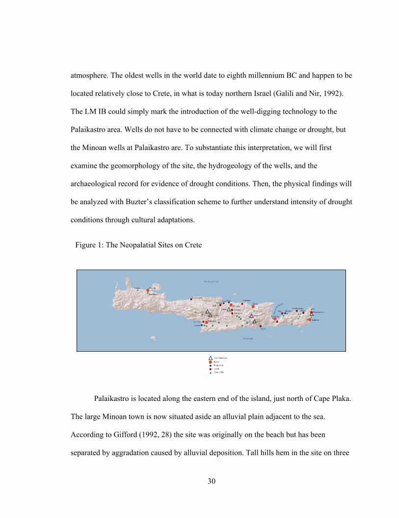
Palaikastro is located along the eastern end of the island, just north of Cape Plaka.
The large Minoan town is now situated aside an alluvial plain adjacent to the sea.
According to Gifford (1992, 28) the site was originally on the beach but has been
separated by aggradation caused by alluvial deposition. Tall hills hem in the site on three
Figure 1: The Neopalatial Sites on Crete

31
sides; atop a hill south of town the Minoans erected the peak sanctuary of Petsophas.
From the town the hills rise up gradually to the north. The area is crossed by several
ephemeral stream channels that have carried sediments from the neighboring hills for
centuries. The hills north of the alluvial plain are covered with an extensive Miocene
deposit of Offlap’s compact conglomerate with lenticular intercalations of sand and marl.
Seasonally streams course across nappes of phyllite and dolomite in their upper reaches
but dive underground once they reach the sandy plain. This phenomenon is termed
‘disappearing stream’. A couple of faults dissect the area; one to the west of the site
running north-south, the other is east-west oriented and runs in close proximity to the
town site. The east-west trending fault explains the different bedrock units exposed to the
north and the south of the alluvial plain. A stream channel once followed the fault to the
sea, but today it is choked with sediment and nearly invisible.
Figure 2: Geologic Map of Crete, Eastern Section, 1:50,000 From the INSTITUTE OF GEOLOGY, 1993
32
The large Minoan town was erected upon the bedrock surface of “yellowish marly
sandstone” (1:50,000 Geologic Map of Crete, Sitia Section). This Miocene deposit forms
the southern boundary of the alluvial plain and can also be seen exposed at the base of the
Kastri, a flat-topped promontory along the coast. All major structures at Palaikastro
appear to have been built directly on the shallow bedrock surface (Gifford, 1992). In
Block Γ, a basin was cut into the sandstone bedrock and two ‘skid-proof’ slabs of
sandstone were installed as steps leading down into the basin (Gifford, 1992).
Many of the Minoan structures in Palaikastro (including the wells) incorporate
ashlar masonry in their architecture. The bronze-age inhabitants of the town quarried
blocks from two different sources. Stones of dense gray dolomite were mined from an
extensive exposure of Triassic-age bedrock immediately southeast of the site. Fine
sandstone blocks were produced from another quarry named Ta Skaria located along the
shore to the southeast of the site. Both of these quarries were open-pit-mines and
removed blocks from the surface down. A number of ornamental floor and paver-stones
of green and red phyllite were used in constructions at Palaikastro. These stones were
collected from the coastal bedrock exposures located a few kilometers north of the site
(Gifford, 1992). Several of these colorful phyllite slabs were emplaced as pavers to
prepare the surface around the well 576 (Thorne, 2007).
Excavating at the Palaikastro site between the years 1902 to 1906, R. C.
Bosanquet remarked on the relatively high water table around the area (Gifford, 1992).
Bosanquet’s efforts were focused primarily southwest of the Minoan town. During his
campaign, Bosanquet discovered and excavated two Minoan wells located in the

33
periphery of the town proper. Because of the relatively high water table during the early
20th century, Bosanquet could only excavate the wells to a depth of 4.5 meters below the
surface before they filled with groundwater (Gifford, 1992). This translates to a 1902
water table around 8 meters above sea level. The water table had dropped to roughly 3
meters above sea level by 1994 (Thorne, 2007). Judging from the depth of the wells and
cultural material contained in their lowest sections, it becomes apparent that the water
table was around 3 meters above sea-level or perhaps a bit lower during their LM IB
construction.
Freshwater is scarce on the Palaikastro plain; one has to dig to find it. As outlined
in the climate section, the easternmost sliver of Crete can be quite desert-like. Only the
rugged mountain peaks in the area consistently receive more than 300 mm of
precipitation in a given year (Rackham and Moody, 1996). Rainwater streams down the
hills and the flow typically becomes subterranean once in contact with the sand-rich
alluvial plains. A perennially flowing river has not been noted in the eastern end of the
island since 1625 AD (Rackham and Moody, 1996). Without surface water, springs and
wells have had to supply local inhabitants of the Palaikastro plain and its hinterlands with
freshwater throughout modern history (Thorne, 2007). Only with the introduction of
piped municipal water did the numerous wells in the region fall into disuse (Thorne,
2007). With such a long tradition of groundwater extraction in the area, it might seem
unproductive to place such an emphasis on wells just because they date to the Bronze
Age. It is not. The five wells at the Palaikastro mark a turning point in climate and
society. Before these wells were sunk, other sources of freshwater must have been
34
available to support the earlier Bronze Age communities. Perhaps a now buried spring
gushed forth or a river meandered past the site, following the ancient fault line. A focused
geomorphic survey of the area might shed some light on the paleohydrology of the area.
Whatever the previous water source or sources, by the LM IB period they had either
become insufficient to meet the town’s needs or vanished entirely. This begs the
question, why the sudden change?
The archaeological record demonstrates a decline in population at Palaikastro
during the period the wells were installed. A number of houses and other buildings
constructed on the site at the beginning of the New Palace period (1700 BC) were
abandoned following the eruption of Santorini (MacDonald and Dreissen, 1997). In fact,
well 576 was placed in one of the abandoned buildings; the roof was apparently removed
and the floor around the wellhead was paved with multicolor stones. It seems highly
unlikely that an influx in population would have strained local water resources, especially
enough strain to necessitate a water acquisition project that required such a high labor
investment. These wells were hand dug, with bronze tools and pots to carry dirt away.
Therefore, it seems improbable that a population influx could have placed a strain on the
water resources in the Palaikastro area in the LM IB period.
Wells are not normally constructed to control an excess of water in an
environment, just the contrary. If torrents were streaming past or nearby the site during
the LM IB period, the Palaikastro wells would have been unnecessary. Furthermore, if
the water table were high enough to support surficial streams then the wells could not
have been excavated to the depth they were; the well digger would have needed gills. A

35
closer look inside the largest of the Palaikastro wells, well 576, provides not just
information about previous groundwater levels but also about a particular hydrogeologic
situation that clearly indicates an advanced stage of drought.
Figure 3: Plan View of Palaikastro. From Driessen, et al., 2007.

36
Unlike the other four wells at Palaikastro, only the top two to three meters of well
576 were encased in a stone lining. Covering the shaft walls with stone helped reduce
weathering and erosion of the sedimentary bands exposed after the well was opened; this
practice is observable in newer wells in the area (Thorne, 2007). The lack of casing in
well 576 affords a unique vertical glimpse of the geologic strata of the Palaikastro plain.
Figure 4: Profile of Well 576 at Palaikastro. From Driessen, et al., 2007.
37
Far from homogenous, the geologic substrate alternates with beds of various characters.
Buildings on the site were erected directly on top of marly sandstone. This represents the
first bed in the well sequence and is mostly obscured behind the well casing in the
diagram. It is unclear whether the Minoans first broke ground before the plain filled with
the amount of alluvial material witnessed today, or, if they cleared the area before laying
down foundations. It seems likely that it was mostly the first but partly the second. The
plain has much aggraded since the Bronze Age; it formed the archaeological site. The
sandstone bed extends a little over 2 meters below the surface and sits atop a 2.5 to 3
meter thick layer of conglomerate. The stone lining sat on a lip carved into the junction of
these two rock types. Conglomerates are the most easily identifiable of all sedimentary
rocks. They are essentially a solidified gravel formed of pebbles and sand cemented
together. Their particular makeup is easily identifiable with the naked eye. Many were
assembled in channels of ancient rivers and others were created along the seashore as
wave action abraded and broke rock outcrops to produce gravels. The excavators describe
the rock as a “hard small-stone conglomerate” (Thorne, 2007:11). The cementing agent is
likely calcite (calcium carbonate) in conglomeration with the mineral matter of quartz
(SiO2). The pebbly clasts are roughly between 4 - 64 mm in diameter of an unnoted
material. The conglomerate outcrops in several places in the Palaikastro valley. Due
south of the Minoan town more of the rock clings to the foot of a dolomite massif that
rises from the plain; the Petsophas sanctuary sits atop this peak. The conglomerate is
concentrated along the coast and disappears with altitude. The rock is labeled dl-st on the
geologic map. Back in the well, the conglomerate bed gives way to a nearly one and a

38
half meter thick lens of marl. Marl is a clay rock rich in calcium carbonate and is
sometimes called calcareous clay, mudstone, or simply shale. This material can be highly
erodible, easily weathered back to loose grains when fractured and exposed to water and
air. The Palaikastro marl bed is described as fine and powdery and Thorne (2007) notes
the quality and workability of the marl’s clay when pulverized and moistened. Due to the
material’s feebleness around the elements, the west side of the marl-bed in the well
exposure has weathered away. Water flows from west to east across the plain and this
helps explain the cardinality of weathering. The void left by the weathered and eroded
marl forms a meter or so high natural cave. Small stalactites (0.03-0.11 m in length) that
grew from the conglomerate cave-roof were found during the course of excavation and
serve as testament to the cave’s antiquity. Because of the difficulty and danger involved
in excavating such a small, unstable opening it is left unclear how far westward the cave
extended. The floor of the cave is a soft sandstone, the next layer in the stratigraphic
sequence. The soft, permeable sandstone bed is 2 – 2.5 meters thick and sits atop yet
another layer of marl. The LM IB well diggers removed approximately 0.5 - 1 meter of
second bed of marl and stopped.
The alternating beds of sandstone, conglomerate, and marl form a natural aquifer
from which water can be collected. Precipitation falling to ground and water flowing
across the surface easily infiltrates the sandy soil and then the sandstone below.
Intergranular pore space in sand is high and water, compelled by gravity and osmosis,
tunnels earthward through the millions of tiny passageways left around each jagged grain.
Sandstone, essentially consolidated sand material, has undergone compaction and

39
cementation in digenesis which reduces the size and number of pore spaces for water
molecules to travel through; however, since the cementing agent bonding sand grain to
sand grain is often calcite (calcium carbonate, a substance that readily dissolves in
rainwater) pore spaces become wider with use. Water percolated through the sandstone
bed underlying the Palaikastro valley to reach the conglomerate layer below.
Conglomerate can be even more permeable than sandstone. The coarseness of its material
constituents often leaves larger pore spaces for water to travel through. Water would
continue its journey downward, some of it flowing eastward to the sea, through the
conglomerate bed. Upon reaching the more impervious marl the water would pause and
perch. Thus, the marl bed is considered an aquatard and serves to create a natural aquifer
just above the deposit approximately 7 meters above sea level. Aquitards are
impermeable rock or sediment layers that hinder or prevent water movement. An aquifer
is a permeable rock or sediment stratum that transmits groundwater freely. It is along the
junction of beds of differing permeability that lenses of groundwater occur. At least two
aquifers are present in the sedimentary bedding at Palaikastro. The first is located along
the junction of the conglomerate and the marl layers at 7 meters above sea level and the
second is at the junction of the sandstone with the second layer of marl at approximately
3 meters above sea level. Bosanquet’s 1902 well excavations were thwarted by water
infiltration at exactly the level of the first aquifer. Around the turn of the 20th century,
rain and snowfall that feed the aquifers must have been much higher than they were in the
LM IB period and in 1994 AD. Below the first layer of marl stretches another bed of soft
sandstone (likely described as ‘soft’ because of weaknesses created by a number of pore
40
spaces within the material). This layer of sandstone, like the sandstone and conglomerate
layer above it, is considered an aquifer. Water can move through the porous sandstone
with relative ease. Water would move earthward through the sandstone, propelled by
gravity, until it reached the next layer of marl situated below the sandstone. Water is thus
sandwiched in a layer of sandstone between two impermeable beds of marl. The LM IB
well diggers had to excavate through nine meters of rock to this second marl layer in
order to find a reliable source of freshwater.
It was at the second, lower aquifer that the 1994 AD archaeological excavators
discovered freshwater at the Palaikastro site. Fortuitously, the 1994 excavations of the
Palaikastro wells coincided with a severe drought that affected much of the
Mediterranean basin. The 1994 drought damaged thousands of trees along the coast of
Spain and the disturbance was even recorded in the growth rings of trees as far away as
central Turkey (Akkemik and Aras, 2005). The precipitation data recorded in the tree-
rings appears to be highly correlated with the precipitation history in eastern Crete.
Bosanquet’s 1904 expedition in the area corresponds with a wet-period recorded in a
thick growth ring. The early to mid 1990’s drought event produced attenuate growth
rings, which indicate dry conditions. The disastrously dry period from 1950-52, which
affected the entire island of Crete is even recorded in the tree-rings of central Turkey
(Rackham and Moody, 1996). The comparable groundwater level in 1994 AD and in the
LM IB period indicates a comparable water deficit. Yet, from what we understand about
the Middle and Late Bronze Age climate through a host of environmental proxies, the
period appears to have been wetter and cooler than in recent history (Rackham and

41
Moody, 1996). The fact that Crete was cooler and wetter during the Middle Bronze Age
and the beginning of the Late makes an analogous water deficit between the 1994 AD
and the LM IB period even more consequential. Today, the Palaikastro area only receives
an average of 300-500 mm of rainfall annually, thus a precipitation deficit could be any
value less than 300 mm. If Palaikastro was cooler and wetter during much of the Bronze
Age, and received more like 1100-1400 mm annually (the precipitation regime for most
of west Crete today), then a year or several years of rainfall less than 300 mm would be
catastrophic. As difficult the drought must have been, life continued at Palaikastro during
the LM IB period. The residents of the town likely adapted to the LM IB drought in a
myriad of ways, but only a few of these adaptations made it into the archaeological
record. The five wells and a basin carved into the sandstone bedrock are the most obvious
measures for drought mitigation for the LM IB period at the site of Palaikastro, but are
likely not the only ones.
Figure 5: Time Series of Tree Ring Growth for the Modern Period. From Akkemik and Aras, 2005

42
By analyzing the drought mitigation measures employed at Palaikastro during the
LM IB period with Butzer’s (1982) Model for Scale Changes in an Ecosystem and the
Model for Short and Long-term drought responses, more details about the drought event
and Minoan society become apparent. According to Butzer’s (1982) model the LM IB
drought would fall between a small and medium scale variation in the ecosystem, likely
between a second and third order disturbance. Second order environmental variations
persist for a decade or more and usually cause fluctuations in seasonal availability or
aperiodic availability of water. During a second order event primary productivity
diminishes along with plant and animal biomass. The 1900-1960 dry-spell in East Africa
is a historic example of second order variability within an ecosystem. Because Butzer’s
Figure 6: Reconstructed Precipitation Rates for Central Turkey Based on Tree Ring Data. From Akkemik and Aras, 2005

43
second order class does not account for fundamental changes in hydrology, this part of
the third order classification scheme must be included. Adding even part of the third
order class pushes the estimated duration of the LM IB drought event close to a century,
which roughly encompasses the entire LM IB period. Increasing the scale of the LM IB
drought helps explain why and how the water table could drop so low during a period
when rainfall averages should have been much higher than what they are today.
Increasing the temporal scale of the LM IB drought also helps to explain the proactive
approach and the scale of the adaptations. According to Rossi (2006), even with modern
technology, the construction of a well constitutes a long-term solution. The wells at
Palaikastro were hand-dug with bronze tools and muscle. This has obvious implications
on the ‘costs’ of the projects. Also, since the creation of water-wells is classified as a
long-term measure it implies that the event that necessitated their construction was
perceived as equally lasting by the Minoans.
Reactionary approaches are created during a drought event, whereas proactive
approaches are installed following an event that is expected to return. Expectations of
annual variability in an ecosystem often take more than one year to develop (Mortimore,
1989). Thus, it not expected that the Minoan inhabitants of Palaikastro experienced a
summer drought one year and excavated wells the next. Uncertainty in the environment
develops sequentially, much like the progression of drought. More than likely, moderate
drought events occurred on east Crete several times before Minoan society perceived the
cyclical nature of the phenomenon.
44
The placement and contents of well 576 and well 605 within the large town
presents valuable clues concerning their specific uses. The lowest deposit in both wells
contained pottery solely from the LM IB period. Nearly all the pottery in this deposit
consisted on water-bearing vessel forms, (e.g., trefoil mouth jugs). The fact that well 576
contained over fifty individual vessels dating to the LM IB period indicates that the well
was in use for a considerable time. Since the site was destroyed and abandoned at the end
of the LM IB period, 1450 BC, the fifty plus vessels indicate that the drought and the
creation and use of well 576 occurred sometime before the fall of Minoan civilization
(1450 BC). Fifty plus vessels, however, has temporal implications. Since the LM IB
period was only about 100 years long, approximately 1530 – 1450 BC, the average rate
of vessel deposition should only be about 1 vessel every two years. This rate seems
extremely low by any archaeological standard. It is more likely that the drought that
necessitated the Palaikastro wells occurred towards the end of the LM IB period. A more
detailed seriation study of the pottery recovered from the lowest deposit in the Palaikastro
wells would afford a better relative or even absolute date for the LM IB drought event.
Thorne (2007) suggests that the abundance of jug vessels at the LM IB level and the
diameter of the wellhead for well 576 implies communal use of the feature and its water.
The central location of well 576 and 605 within the town supports Thorne’s position.
Well 576 was situated adjacent the main avenue of the town and appears to have been
especially accessible.
Alone, the wells at Palaikastro make a convincing case for an LM IB drought. The
wells were the first of their kind in the area and the date of their original construction is

45
unquestionably LM IB. Hydrogeologic information gathered from the exposed
stratigraphy inside well 576 builds an even more convincing argument. However, it is
only by looking at other archaeological sites with adjustment artifacts that the true nature
of Neopalatial drying event becomes evident.

46
CHAPTER VII
THE GEOGRAPHIC DISTRIBUTION OF WATER MANAGEMENT FEATURES AND SITES
The geographic distribution of Neopalatial sites on Crete is concentrated in
central and eastern sections of the island. The extensive swath of uninhabited area from
the islands western-end to the eastern-face of the Idaean Mountain Range can be
explained in part by the precipitous topography of the space between. Today, this region
is only pocked by an occasional hamlet or village huddled close to a spring or stretched
beside the occasional strip of level-land. The paucity of Minoan sites in the west could
also be explained by the lack of archaeological surveys conducted in the region. Central
Crete was the most densely inhabited area on the island during the Neopalatial period and
is again the most populous section of the island in modern times. Palaces (the horned
icons) are spaced roughly 40 kilometer from one another, with the exception being the
Figure 7- The Neopalatial Sites

47
isolated palace of Chania in the far west. The palaces in the east—Palaikastro, Kato
Zakros, Gournia, and the possible palace of Petras—are located in coastal settings. The
palaces of Knossos and Phaistos are both located about 5.5 km from the coast and sit atop
small hills that overlook the sea beyond. The palace of Malia is situated less than 600
meters from the lapping waves of the Cretan Sea and is thus more situationally like the
coastal palaces in the east than its central Cretan counterparts. The palaces are assumed to
have functioned as regional centers of commerce, ritual, politics, and cultural life
(Dickenson, 1994). Larger sites of the Late Minoan I Period (black squares) tended to be
located closer to the coast and smaller sites like farmhouses and villas were located
further inland. Peak sanctuaries (hollow triangle) are generally located either atop
mountains commanding expansive viewsheds or in direct association with a mountainside
cave. Peak sanctuaries of the Neopalatial period are typically located far inland. As a rule
of thumb, the LM I inhabitants of Crete preferred low-lying and unprotected areas for
habitation. Coastal sites abounded during this period and even those located inland atop
hills were easily accessible by foot (Pendlebury, 1965). Judging from the exposed
location of most Minoan sites, it appears that the LM I was a period of relative peace, at
least until its end around 1470 BC.
Like Late Minoan I sites in general, Neopalatial sites with adjustment-artifacts
related water deficiency also have a patterned distribution. The areal extent of the
Neopalatial drying event investigated in this study can be elucidated from the spatial
distribution of Minoan water-management features on the island. Furthermore, the spatial
dispersion of the events negative effects can be interpreted from the distributional pattern

48
of the different types Minoan responses to drying conditions. In other words, the areas
where Minoan responses to drought were the most extreme or required the greatest
amount of investment indicate where the drought effects were the most pronounced.
Understanding the spatial extent and the inequalities in the dispersion of the event’s
effects lends further insight into the type of climate or weather phenomenon that affected
Crete during the Neopalatial period.
Minoan water-management features have only been discovered in the central and
eastern two-thirds of the island. As previously mentioned, nearly all of the Neopalatial
sites are located in these two-thirds of the island. There does, however, exist a true east-
west and north-south gradient in the profusion of Neopalatial water-management
features. Generally speaking the density of Minoan water-management features
diminishes as one travels from the east to the west. The same distance decay exists from
north to south, but becomes negligible in the far eastern end of the island where Minoan
waterworks virtually fringe the coast. Sixty-six percent of LM I sites in the eastern third
of the island exhibit a form of water-management attributable to drought response. The
number of sites with drought adjustment-artifacts drops to twenty-six percent in the
central-third of the island. It is interesting to note that nearly all sites along the north-
coast east of the ports of Gazi and Poros had some form of water-management in the LM
I period; over eighty percent of these features were hard-engineered into the landscape or
architecture. The north-south gradient is more difficult to quantify because it lacks a
natural geographic divide from which to base a division. The north-coast certainly has
more sites with water-management features than the south-coast, but the south-coast has

49
very few Neopalatial sites in general whereas the north-coast is seemingly replete. The
east-west and north-south gradient in the profusion of water-management features can be
seen in Figure 1.1, a map of the all known Neopalatial sites with drought adjustment-
artifacts.
Another gradient exists in the distribution of Neopalatial water-management
features, one based on the level of labor investment together with the local water needs
and supply of a site. Oliver Rackham and Jennifer Moody (1996) outlined a choice-tree
of traditional water supply decisions. Where possible, Cretans have chosen to settle
around springs. Countless medieval and modern settlements encircle a bubbling spring or
seep. After springs, the next choice is cisterns. Cisterns require technical expertise to
design and labor to build and maintain, but these investments are typically less than those
involved with the third choice, water-wells. According to Rackham and Moody (1996,
43), wells are a poor third choice for domestic water supply and are only typical in
springless coastal areas and mountain plains. Dams are added to the choice-tree as an
even poorer fourth choice, for they often require more effort to create and maintain than
wells and cisterns. Furthermore, surface water reservoirs are only suitable on the non-
limestone areas on Crete, which number few. Aqueducts, which can be seen today as
concrete troughs slithering through a number of Crete’s dry-plains, are a possible fifth
choice. As far as the archaeological record explains, Minoans did not utilize true-
aqueducts, although small ‘viaducts’ and drains have been documented at Knossos,
Epano Zakros, and elsewhere. Underpinning the choice-tree is the level of effort involved
in acquiring the water resource for a settlement. Water quality and consistency in

50
availability are less of a factor in the decision-making framework once springs are
excluded from the model. All the other water decisions involve risks of vanishing supply
and a higher potential for contamination. Therefore, a simplified correlation exists
between the effort involved and the means of water supply. The terrain being equal,
cisterns will be chosen over wells unless rainfall conditions force the later. Wells will be
created before large dams are erected and so forth. Using the logic provided in the
choice-tree, it becomes reasonable to make some assumptions about the Minoan
perception of the Neopalatial drying-event. At sites where the perceived threat of drought
was high, the effort put into the adjustment-artifact would be accordingly high. In other
words, sites with adjustment artifacts that required the highest levels of energy to produce
were the sites that experienced the highest degree of drought stress. Granted, these
assumptions only hold true in a general sense. When Minoan water-management features
are viewed on a site-by-site basis it becomes apparent that each feature was emplaced
with by a perspicacious hand, one understanding the local landscape, its geology,
morphology and hydrology. But in a regional sense, the choice-tree model explains some
telling patterns in the distribution of the different classes of Neopalatial water-works.

51
Dams and wells were the most technical and labor-intensive features in the
Minoan arsenal against the negative effects of drought. Because of the high investment
required to produce them, dams and wells are considered indicators of high-level drought
stress in this study. Dams (not included on Rackham and Moody’s list) require even more
labor and material investment and technical knowledge than the creation of wells and are
thus considered the paramount feature in Minoan water-management in this study. So far
Minoan dams appear to be solely a Neopalatial phenomenon. That being said, only five
Minoan dams have ever been documented on the island and only three of them
thoroughly studied and published (Betancourt, 2005). Of the five reported, four are
located in the eastern-third of the island. The fifth is located in the Mesara plain
southwest of the modern village of Kamilari (Watrous et al., 1993). This check-dam was
dated to the beginning of the Neopalatial Period and is likely associated with the Minoan
site of Pitsidia. The check-dam is only ca. 75 cm high and survives as a single course of
undressed stones (Watrous et al., 1993). It is difficult to call the Pitsidia check-dam a true
Figure 8- Neopalatial Sites with Water Management Features

52
check-dam when compared to the dams on the islet of Pseira. The two Pseiran check-
dams measure over 2.7 m in height where they can be observed (Betancourt, 2005). The
Pseiran dams were undoubtedly higher at the time of their original LM I construction.
South of Pseira sits the small palace of Gournia and beside it a small check-dam. The
Gournia check-dam has received mention in publications but the features dimensions
have yet to be published. The Minoan town of Mochlos is located a little less than 4 km
east of Pseira and another 4 km east of Mochlos sits another Minoan check-dam.
Stretched across a narrow but steep defile adjacent the LM IB farmhouse of
Chalinomouri rests the remains of an earthen check-dam discovered by J. S. Soles (2003,
104). Over 30 km southeast from Chalinomouri, just inland from Crete’s eastern shore is
the Minoan site of Choiromandres. The grandeur of the dams at Choiromandres is on par
with those on Pseira. The highest surviving dam at Choiromandres measure 3.10 m off
the ground, but like those on Pseira it was likely higher at the time of construction
(Chryssoulaki, 2009). If dams can be understood as indicators of drought’s frequency and
magnitude, then the eastern third of the island appears to have been more frequently and
severely affected.
The technological know-how for digging water-wells had arrived to the island
roughly thirteen hundred years prior to the Neopalatial Period. In 1966, Sinclair Hood
excavated an Early Minoan II well which had been dug into Kefala Hill near Knossos
(MacGillivray et al, 2007). Another well possibly dating to the Early Minoan Period has
been discovered on the island of Mochlos, but is awaiting publication. Well-digging
activity apparently dwindled and/or ceased for much of the Protopalatial Period, but was

53
resumed at the beginning of the Neopalatial with fervor. Perhaps Crete was an overall
wetter place during the Protopalatial period and wells were simply not needed. Whatever
the environmental scenario of the Protopalatial, the archaeological record demonstrates a
marked increase in the creation of wells during the Neopalatial period, especially in the
LM IB. Neopalatial wells from east to west are located at the sites of Palaikastro, Zakros,
Chryssi, Nirou Chani, Archanes, Amnisos, and Knossos. There are at least five wells at
Palaikastro, two of which have been confidently dated to the LM IB (1570-1450 BC), the
final chapter in Minoan Crete. Constructed into the heart of the East Wing of the Palace
of Zakros is a shallow well accessed by a series of steps (Platon, 1971). Platon named an
adjacent feature a ‘spring well’, but because the feature is reported to be enclosed, lined,
and fed via a drain from another source of water, the ‘spring well’ is understood as a
cistern in this study. Several wells riddle the flat surface of Chryssi around the Late
Minoan IB buildings on that tiny, windswept island. Freshwater from the wells on
Chryssi was recently tested to be rather saline, but still within range of human
consumption. At the Neopalatial coastal settlement of Nirou Chani, ceramic material
from the very bottom of a well confirmed the features LMIB date of construction
(MacDonald and Driessen, 1997). The well at Archanes was initially and most formally
constructed at the beginning of the Neopalatial period (MM III/LM IA). After being
damaged by seismic activity the well was haphazardly repaired and used in the LM IB.
At the site of Amnisos, north of the so-called “Villa of the Lilies” sits a small well-house
near the beach. The Amnisos well is believed to be Neopalatial in date, but material from
a period of reuse in the LM III pollutes the pottery analysis (MacDonald and Driessen,
54
1997). The well in the vicinity of Knossos is located just north of a Neopalatial building
called Hogarth’s House. Hogarth originally excavated the structure sometime around the
turn of the 20th Century (MacDonald and Driessen, 1997). The pottery material from the
well suggests a MM III to LM IA date of construction. The well went out of use at the
end of the LM IA. Unlike the Archanes well, which went out of use temporarily during
the LM IA to IB transition, the Hogarth well remained out of use throughout the LM IB
and beyond. In the context of this investigation, wells take an even distribution between
the central and eastern thirds of the island, whereas dams were a primarily eastern
phenomenon.
Many Roman buildings on Crete relied on cisterns, but during the Bronze Age
they were much less popular on the island. In attempts to explain the multiple stone-lined
circular depressions at the palaces of Knossos, Mallia, and Phaistos some archaeologists
labeled them cisterns. Today, that label has been removed and replaced by a more
accurate description ‘grain silo’. Only five of the proposed cisterns were recognized in
this study to be true cisterns dating to the Neopalatial. The cistern at Myrtos, carved into
a hill overlooking the Libyan Sea, may date solely to the Protopalatial period, but further
archaeological work is needed to determine this (MacDonald and Driessen, 1997). When
Myrtos is excluded from the analysis, all but one of the true Neopalatial cisterns is
located in the central third of the island. Furthermore, the one reported cistern that
undoubtedly dates to the Neopalatial period is at the site of Kato Zakros. As mentioned
earlier, Nicolas Platon, the site’s excavator, often put a literary touch on archaeological
interpretations, and what he called the Royal Cistern, although regal in construction and

55
placement, is not a cistern, at least from an engineering standpoint (Platon, 1971). The
Zakros cistern was not fed directly by rain-water, rather functioned to slow and retain
groundwater that was making its way to the sea (absolute base-level) just beyond the site.
Zakros is encircled by hills on three sides and rests on a small alluvial plain about 2 m.
above sea level. The geomorphological setting of Zakros attributes to the relatively
shallow water table. It is no coincidence that both the well mentioned earlier and the
‘cistern’ mentioned here only reach a depth of 2 meters. The Zakros ‘cistern’ is more like
the ‘Spring House’ or Caravanserai at Knossos than the other true cisterns on the island.
If the Zakros cistern is removed from the distribution analysis, then cisterns become
totally a central Cretan phenomenon. The true Neopalatial cisterns are at Anegyros,
Archanes, and Prinias.
The distribution of waterwork types indicates that the eastern third of the island
required more of a labor and material investment to satiate the water needs of the various
sites located there. Eighty percent of dams are at sites in the east. Seventy-five to one
hundred percent of the cisterns are located at central Cretan sites. Wells span the
difference, being equally represented in both the eastern and central thirds of the island.
This gradient in waterwork type suggests that the eastern third of the island was drier
than the central part, and certainly drier than the west. The east-to-west trending pattern
of dryness implied by the Neopalatial water management features correlates with east-
west dryness today. The eastern third of the island receives the least amount of rainfall
and experiences the longest duration of the summer drought of anywhere on Crete. The
slip of shoreline on Crete’s eastern fringe, where the Minoan sites of Palaikastro, Kato

56
Zakros, and Choiromandres are located, rarely receives over 300 mm in annual
precipitation and is therefore literally a desert (Rackham and Moody, 1996).
Interestingly, these three sites not only exhibit some of the paramount works of Minoan
water management, they are all sites where Minoans employed multiple strategies to
meet water demands. Kato Zakros, for example, utilized wells, springs, gutters, drains
and pipes to manipulate humankind’s most precious resource, water. The southeast
corner of Crete is the islands driest area and receives an estimated 240 mm of
precipitation a year or less. Just for reference, this is less than the annual average of
Benghazi, Libya (253 mm annually). Conversely, the western third of Crete is by far the
island’s wettest place. The average precipitation value for the entire western section of
Crete is a higher number than the value recorded in the wettest location in the eastern part
of the island (Rackham and Moody, 1996). In other words, the wettest place in the east is
not even on par with an average site in the west. The central section of the island is more
of a patchwork of wet and dry places today. In the Psiloritis Mountains precipitation is
generally over 1,100 mm a year, while rainfall in the rolling-hills and plains between
Knossos and Phaistos averages 500-800 mm annually. 500 to 800 mm of annual
precipitation is roughly the average for multiple sites in east Crete, including Mochlos,
Pseira, Gournia, Chalinomouri, Papadiokampos, and Vasiliki. Interestingly, the driest
regions in the central section of the island today directly correlate with Minoan sites that
had some form of water-management in the Neopalatial period. For example the north-
central shore between Poros and Malia receives less rainfall than anywhere else in central
Crete, save the dry strip of coast at the western edge of the Mesara Plain. It is between

57
Poros and Malia that one finds the sites of Amnisos (well), Knossos (well, spring house,
viaduct, drainage), Nirou Chani (well), Kastelli Pediados (gutters, drains), and Archanes
(well, cistern). That other slip of dry land mentioned at the end of the Mesara Plain is
where one finds the Neopalatial sites of Pitsidia (dam) and Anegyros (cistern), the other
Neopalatial sites in Central Crete with hard water management. It should be apparent by
now that the dry areas of Crete today were also the areas where Minoans had to invest
time, labor, and material to satiate their water needs. With the distributional pattern of
water-management features and dispersion of water-management types understood, it is
now possible to understand which of the hypothesized drying events the features most
accurately reflect.
Acute episodes of drought have affected Crete in the recent past. The summer
drought of 1950-51 remains the driest year Crete has experienced in recorded history
(Rackham and Moody, 1996). Although the 1950-51 drought was acute and had dramatic
effects, the response to it was minimal in terms of manipulation to the landscape and the
materials of society. On the other hand, the consistently dry regions of the island, like
many areas in the east, are places where people invested significant time, energy, and
material into slaking their water needs. These consistently dry places are not just areas
where rainfall was at a minimum; these are the areas where the seasonal distribution of
rainfall is at a maximum. For example, the eastern third of the island and a strip along the
central-southern border are regions where the dry-season extends for at least six months
or more (Grove and Rackham, 2001). Areas with six or more months without rain
obviously require some adjustments in human society or the landscape to allow

58
successful habitation in the long-term. The correlation between the areas where the dry-
season is severe today and the areas where Minoan’s invested the greatest amount of
energy in water supply suggest that the same motivating factors were at play then as now.
The long dry-season that has motivated modern farmers to dig countless wells in the
Palaikastro area is the same motivating factor that inspired the Neopalatial wells at the
Minoan site that shares the area’s name. The areal extent of the Neopalatial event or
series of events was focused on the east and diminished westward. The worst of the
drought’s effects were also apparent in the east. Both the dispersion and the areal extent
of the Neopalatial event are more representative of the arrival of the Mediterranean dry-
season than an episode of acute drought. The nature of the Minoan response also reflects
a gradual progression of a drying climate more than the typical reactive response to an
erratic drought.

59
CHAPTER VIII
UNDERSTANDING ANCIENT RESPONSE TO ENVIRONMENTAL HAZARD THROUGH ETHNOGRAPHIC ANALOGY
Human response to environmental hazard is fundamentally determined by the
perception of the phenomenon and the awareness of possible adjustments (Burton et al.
1993). When studying environmental hazards through the archaeology of human
response, perception of an event can only be understood in broadest of terms. This is
because the only traces of perception are embedded in a certain assemblage of artifacts,
those created as direct or incidental adjustments to an environmental perturbation.
Artifacts of environmental adjustment (henceforth adjustment-artifacts) allude to the
range of possible adaptations a given society was cognizant of at a particular time and for
a specific event; however, the true adaptive range an ancient society was aware of cannot
be accurately gauged through archaeology. The lack of resolution is due to the disciplines
inherent inability to account for non-material cultural traits or virtually any behaviors that
fail to produce artifactual remains. The imprecise nature of environmental data gleaned
from the archaeological record is mitigated in this study by testing two temporally
dissimilar drying events. The presumption is that environmental hazards with a high and
regular reoccurrence rate have an assemblage of adjustment-artifacts distinct from short-
term, more sporadic events. To support the assumed difference in human behavior with
differing scales of environmental variability, a model of short and long-term adjustments
to drought was created from modern ethnographic sources, namely from annals of

60
Hazard Research Geography. This binary model was built with modern examples of
behavioral adjustments to drought and then repopulated with Minoan behavioral
adjustments to water scarcity evident in the Neopalatial archaeological record. Before
explaining the model and its components, the temporal scales used in its construction
(long-term and short-term) will be discussed and their use justified.
Climate change and shifts in environmental conditions occur at differing temporal
and spatial scales. At times these fluctuations require human communities to make
adjustments or adaptations to society or the landscape in order to continue to inhabit in
these environments. Karl Butzer (1982, 24) categorized scales of environmental variation
into six orders (Table 1). Environmental variations addressed in this study focus on the
first three orders, changes lasting a few years to several centuries. Differing scales of
environmental variations bring forth distinct sets of changes to the natural and artificial
landscape. The nature of these changes is dependent on the scale of the perturbation.
Butzer (1982, 28) provides an outline for the sequence of environmental adjustments in
his Model for Scale Changes in Ecosystems (Table 2). Accompanying changes to the
human formed landscape are discussed later in this section with the use of the human
adaptive model.

61
Scales of Environmental Variation (After Butzer 1982:24, Table 2.2)
First order (less than 10 years): Year-to-year oscillations, including the 26-month atmospheric “pulse,” the Great Plains dust bowl of 1934-1939, and the Sahel drought of 1971-1974. Second order (several decades): Short-term anomalies, such as well-defined trends in the instrumental record, including the Arctic warmup of 1900-1940 AD and the dry spell in East Africa 1900-1960 AD. Third order (several centuries): Long-term anomalies, such as the worldwide “Little Ice Age” of about 1400-1900 AD or the warm European “little optimum” of 1000-1200 AD, of sufficient amplitude to show up in geological records; third-order climatic variations include repeated oscillations during the 10,00 years of the Holocene. Fourth order (several millennia): Major perturbations, such as severe interruptions within the last interglacial, the stadial-interstadial oscillations of the last glacial, and the warm and often drier millennia between 8000 and 5000 years ago (altithermal, climatic optimum). Fifth order (several tens of millennia): Major climatic cycles of the order of magnitude of glacials and interglacials, spanning 20,000 to 70,000 years, with eight glacials verified during the last 700,000 years. Sixth order (several million years): Geological eras, including the durations of ice ages such as the Permocarboniferous (ca. 10-20 million years long, about 290 million years ago) and Pleistocene (formally began 1.8 million years ago, with major cooling evident for 3.5 million years).
Models for Scale Changes in Ecosystems (After Butzer 1982:28, Table 2.4)
Small-Scale Variability (First and Second Order)
Medium-Scale Variability (Third and Fourth Order
Large-Scale Variability (Fourth and Fifth Order)
Year-to-year anomalies, or cyclic variations, up to several decades.
Dynamic equilibrium, with major perturbations or low-threshold equilibrium shifts lasting a few centuries or millennia.
High-threshold, metastable equilibrium changes, with biome shifts during the course of several centuries but persisting for millennia, even tens of millennia.
Steady-state or dynamic equilibrium. No change in stream behavior or biochore definition.
Fundamental changes in hydrology, productivity, and all categories of biomass.
Hydrological and geomorphic systems include new components, creating different soil and sediment assemblages.
Fluctuations aperiodic availability of water, primary productivity, and biomass of plant foods.
Shifts in soil-slope balance favor readjustments of stream behavior, with downcutting or alluviation, tangible in geologic record
New ranking of dominants and subdominants in biotic communities, with transformation in biome physiognomy and biochore definition.
Affects resource levels for macroconsumers and animal biomass; impact greatest in biomes with low predictability.
Qualitative composition of biotic communities persists, but quantitative changes affect mosaic structures in general and ecotones in particular (e.g., species number and selected population densities): minor changes in biochore definition
Geological and biotic discontinuities provide stratigraphic markers tangible over continental areas.
Table 1: Scales of Environmental Variation. From Butzer 1982:24, Table 2.2
Table 2: Models for Scale Changes in Ecosystems. From Butzer 1982:28, Table 2.4

62
According to Butzer (1982, 23), a discord exists between the levels of changes to
the natural environment as a result of first and third-order events. This study will frame
the short, acute drought proposed by archaeologists to explain the appearance of certain
LM waterworks as a first-order event, lasting a single year to several. The gradual drying
accompanied by a pronounced antipodal distribution of rainfall now referred to as
Mediterranean climate is categorized in the third-order for this study. The arrival of the
Mediterranean climate would be categorized as a fourth-order if the climate had remained
constant until today. As it were, the Late Bronze Age drying discussed in this study gave
way to a relatively wet period during the Classical Greek Age, around the 5th Century BC
(Grove and Rackham, 2001). To nominally distinguish the two types of drying analyzed
in this study, the short-term event is dubbed an erratic drought while the long-term event
is referred to as annual drought. It is recognized that erratic drought is perhaps a bit of a
misnomer, for as can been seen in the Table 1 first-order events like the American Dust
Bowl can and often are very cyclic.
Table 2 models the changes in ecosystems at three scales of environmental
variability. Small-scale variability, like erratic drought, causes fluctuations in the
aperiodic availability of water and can in turn affect the primary productivity and overall
biomass in an area. It is important to note that neither first-order nor second-order
variability stir lasting changes in the biochore of an area. Biochore refers to a subdivision
of the biosphere based on uniform environmental conditions that provide a living place
for a specific assemblage of plants and animals. In other words, small-scale variations do
not affect the habitat composition of an effected area. It takes medium or large-scale

63
variability in an ecosystem to permanently rearrange or transform plant and animal
communities. Medium-scale variability in an ecosystem is also the first level of scale to
affect hydrology, which may result in either the incision or alluviation of streams as
noted by Butzer (1982, 30). General changes in hydrology also imply changes to the
groundwater system. As evident from depth of the Palaikastro wells discussed later,
groundwater levels dropped dramatically during the Neopalatial period in the northeast
section of Crete. The bottom-most box in the medium-scale category offers perhaps the
most insightful information for distinguishing the scale of the Neopalatial drying event
from environmental data alone. It states that medium-scale variations result in
quantitative changes in the compositional structure of plant and animal communities in an
effected area. Changes in the mosaic of species structure are particularly apparent in
ecotones, which are transitional areas between dissimilar habitats. Palynological evidence
from the Akrotiri Peninsula in northwest Crete, an ecotone between coast and foothills,
suggests a change in vegetative structure at the beginning of the Neopalatial period.
During this time agricultural activity apparently declined in the area and allowed for wild
vegetation to reestablish itself on the landscape. Interestingly, instead of reverting back to
the garigue-woodland mosaic that dominated the area prior to cultivation, a mosaic of
steppe and woodland became established on the peninsula (Moody, 1997). Garigue is
characterized by low open scrubland with many evergreen shrubs, low trees, aromatic
herbs, and bunchgrasses densely interspersed. Steppe on the other hand uniformly
describes communities of hardy grasses. A steppe-woodland mix is another way of
describing savannah vegetation. The Akrotiri peninsula is mostly savannah today. It is
64
important to note that steppe becomes dominant over garigue with increasing aridity.
Although human land-use helps explain fluctuations in olive pollen and the
disappearance of the linden (lime) from Crete during the Bronze Age, it cannot account
for a structural shift in biochore in an area left wild. For this reason, J. Moody (1997, 71)
concludes that the Akrotiri shift in vegetation mosaic marks the development of the
Mediterranean dry-season on Crete for the present interglacial. In a previously published
book, J. Moody and O. Rackham (1996, 39) suggested that the Mediterranean antipodal
distribution of rainfall developed gradually over the course of the Aegean Bronze Age.
The vegetation shift that is apparent in the Akrotiri pollen core syncs well with this
position. The mosaic change could simply reflect the point at which vegetation structure
changed in response to a gradual, larger scale environmental drying or rather variability
in the distribution of rainfall. The exact timing of ecosystem responses to environmental
variability does not need to be uniform between all species occupying a particular area. In
other words, the exact timing of adjustments to plant physiology or community structure
do not necessarily correspond with the exact timing of changes witnessed in animal
communities, even though they may be responding to the same environmental stimuli.
Gradual and staggered changes in ecosystems are more difficult to causally unify than
acute broad sweeping changes. For example, think of the differing effects of volcanic
activity in areas within close proximity to a lava flow versus those in distant areas
minutely affected by changes in atmospheric composition due to the same event. With
this species conditional variability in mind, it seems plausible that the increases in water-
management during the Neopalatial period could simply mark the point in time when

65
human groups were forced to adapt to the changing environmental conditions on Crete.
These same environmental variations may have already inspired responses in other
species prior to the human response.
Understanding how and when human groups respond to environmental stimuli is
intrinsically different from understanding how other organisms or even the abiotic
systems respond to the same set of environmental variables. This difference exists
because humans tend to adapt to environmental stimuli with behavioral adjustments
rather than with a physiological response. The more persistent the environmental
perturbation the more pervasive the behavioral adjustment and the faster the human
behavioral adjustment becomes a cultural adaptation (Burton et al., 1993). Cultural
adaptations are to be understood as ecological behavioral adjustments that persist long
enough to become engrained in to the cultural fabric of a society. Cultural adaptations are
much more rapid than biological adaptations and are responsible, at least in part, for the
success of our species. That being said, not all cultural adaptations end up being a
positive influence on the longevity of our species. Mortimore (1989, 3) explains that
cultural adaptations, specifically those that arise in response to drought, should not be
viewed as a deterministic one-way response to environmental stimuli, but rather
understood as a sequential process in which solutions to problems become in turn a part
of the next problem. Mortimore’s ideas ride on the back of Bennett’s (1976) realization
that the distinctive feature of human cognition lays in its anticipatory characteristics.
Bennett recognized behavioral or social adaptation as a chain of problems and solutions,
with each solution engendering yet another problem (Mortimore, 1989). Cultural

66
adaptations and behavioral adjustments of interest to this study pertain only to those
human activities that attempt to reduce the damages incurred by diminishing water
supplies in an environment. These attempts may be direct or incidental adjustments.
Direct adjustments are purposefully adopted for a particular function whereas incidentals
are activities, structures, or characteristic behaviors that are not primarily hazard-related
but have the effect of reducing potential losses (Burton et al., 1993). Storage of feed and
seed in domestic and palatial systems are an example of an incidental adjustment
recognized in this study; feed and seed stocks may have reduced potential losses during
drought but were not likely initiated because of a drought. Another point to make about
the social adjustment model presented below is that it is not populated with the full range
of human adjustments to drought. The components of the model were instead selected
from behavioral responses of complex agricultural societies that are not fully immersed in
a global economy. This attempt at selectivity was not fully realized as can be seen with
several inclusions of examples from the United States; however, but the majority of the
components are from agricultural societies wherein the majority of the population existed
in the rural sector and political control was grounded in regional urban centers. This
distinction was made because it is assumed that the majority of Crete’s Bronze Age
population lived and worked the rural agricultural areas and that commerce and political
authority rested in the scattering of urban nodes (Soles, 2003).

67
Short-term, Reactive Adjustments
Response Theme
Long-term, Proactive Adjustments
Transitory Movements-Nothing Permanent Often Towards Kin-Based Resources
Northern Nigeria (Hankin, 1974) (Mortimore, 1989). Tanzania (Heijnen and Kates (1974).
Plant in Wet, Potentially Hazardous Places Tanzania (Heijnen and Kates (1974).
Change Location
Permanent Relocation Closer to Perennial Water Sources, often at the expense of economic/social convenience Sardinia, Italy (Rossi, 2006). Myrsini, Crete (Authors observations)
Permanent Movement to Cities Brazil (Burton et al., 1993)
Pastoralist Conversion to Sedentary Agriculture Sahel (Burton et al., 1993)
Do Nothing Northern Nigeria (Hankin, 1974).
Sow Less Water Consumptive Crops Tanzania (Heijnen and Kates, 1974).
Planting Seasonal Floodplains Tanzania (Heijnen and Kates, 1974).
Change Use
Permanent Irrigation Works Spain, Italy (Rossi, 2006) Crete, Greece (Rackham and Moody, 1996) United States (Smith, 1971)
Conversion of Agricultural Areas to Other Economic Systems (Industry, Service, etc.)
Availability of Crop Types and Varieties for Various Conditions Oaxaca, Mexico (Kirkby, 1974).
More Thorough Weeding (eliminate moisture waste) Tanzania (Heijnen and Kates, 1974).
Cultivate Larger Areas Tanzania (Heijnen and Kates, 1974).
Work Elsewhere Tanzania (Heijnen and Kates, 1974). Nigeria, k’wadago (Morimore, 1989).
Sell Livestock to Buy Food Tanzania (Heijnen and Kates, 1974).
Expand Fishing Activity Northern Nigeria (Hankin, 1974).
Plant Late Crop Northern Nigeria: late cassava (Hankin, 1974).
Plant Additional Crop Northern Nigeria (Hankin, 1974).
Rapid Overexploitation of Aquifers Spain (Rossi, 2006)
Prevent Effects
Ample Storage of Food and Seed Government Level Seed-Bank. United States, Australia, U.N., etc. Food-Bank. Feeding America. USAID
Local Level Personal Food Storage. Cellars, Barns, etc. Local Seed Keepers.
Agricultural Terracing Crete, Greece (Rackham and Moody, 1996).
Surface Reservoirs Agricultural Ponds Municipal Reservoirs
Domestic Reservoirs Cisterns. Greece (Rackham and Moody, 1996).
Regular Seasonal Exploitation of Marine Resources
Table 3: Short-term vs. Long-term Responses to Water Deficits

68
Improvement of Existing Water Systems Spain (Rossi, 2006)
Liquidating Assets Nigeria: short-term losses (Morimore, 1989. p.66)
Capitalizing on Fish Migrations
Practicing Polyculture or Polyvariety Agriculture to Minimize Risk
Obtaining More and Diverse Lands for Use Crete, Greece (Rackham, Moody, 1996). Greenland (Diamond, 2005) Oaxaca, Mexico (Kirkby, 1974).
Mulching Northwest China (Xiao-Yan Li, 2003)
Control and Distribution of Floodwaters from Summer Flashfloods Oaxaca, Mexico (Kirkby, 1974).
Pray
Northern Nigeria (Hankin, 1974). Tanzania (Heijnen and Kates, 1974).
Employ Rainmakers Tanzania (Heijnen and Kates, 1974).
Consult Medicine Men Northern Nigeria (Hankin, 1974).
Modify Events
Institutionalized Water Rituals and Symbols Spain (Pfister, 2009) Vatican, Italy (Dominguez-Castro et al., 2008)
Establishment of Patron Deities of Rainfall, Fertility, Water and Drought
Saint Solange of Bourges: Saint of Drought Relief Gavampati: God of Drought (Buddhists, India) Mot: Semitic God of Drought and Death Varuna: God of Water (Japan)
Pray Oaxaca, Mexico (Kirkby, 1974). Northern Nigeria (Hankin, 1974). Tanzania (Heijnen and Kates, 1974). Northern Greece, The Balkans (Cook, 1925) Spain (Pfister, 2009)
Annual Sacrifices or Offerings
Stepwise Religious Rogation Spain (Pfister, 2009)
Employ Rainmakers Santorini (Lawson, 1910)
Rain-Magic Northern Greece, The Balkans (Cook, 1925)
Begging Tanzania (Dupree and Roder, 1974)
Regional, Political, or Family-Based Networks of Resource

69
Reliance on Relatives
Northern Nigeria (Hankin, 1974).
Governmental Relief Tanzania (Dupree and Roder, 1974). Oaxaca, Mexico (Kirkby, 1974). Northern Nigeria (Hankin, 1974)(Morimore, 1989).
Use Savings Tanzania (Dupree and Roder, 1974)
Send Children to Kinsmen Tanzania (Dupree and Roder, 1974)
Share
Redistribution Nigeria, Kin-Based Redistributions that
favors collective poverty over variability in success.
Institutionalized Insurance
United States and elsewhere, Farm Insurance
Suffer and Starve Northern Nigeria (Hankin, 1974).
Do Nothing Northwest Nigeria (Dupree and Roder, 1974)
Bear
Suffer and Starve
The behavioral response model is organized into three columns. The central
column labeled Response Theme contains six vertically stacked cells. Each of the six cells
highlights a different theme of human response to drought recognized by Ian Burton,
Robert Kates, and Gilbert White, the pioneers of hazard research (1993, 53). The six
theme cells could further be aggregated into choices of change, acceptance of loss, and
decisions to reduce potential loss. Choices of change include shifting locations or
changes in use, be them changes in the use land or other resource. Some people simply
accept losses without attempts to alter the causes, and as a result either bear the full
burden of damage or share it in some fashion with others (Burton, 1993). The third
choice, to reduce potential loss, typically generates the most conspicuous signature of an
environmental perturbation in the archaeological record. People attempt to reduce losses
caused by environmental hazards either by minimizing potential deleterious effects with
material adjustments or by affecting the natural event itself through supernatural means.
The former produces a greater frequency of material goods to be found at a later date by

70
archaeologists; however, it is the later that appears to be the most universal and initial
response. Prayer is the first and most persistent individual adjustment to drought noticed
from southwest Mexico (Kirby, 1974), to northern Nigeria (Mortimore, 1989), to Spain
(Pfister, 2009), and east to Greece (Lawson, 1910). Flanking the Response Themes are
two columns that contain the types of adjustments noted from ethnographic sources that
correspond to each respective theme. On the left are the short-term adjustments and the
column to the right contains adjustments or adaptations to drought made for the long-
term. The short-term adjustments are intended to accurately represent the types of
responses societies make when affected by first-order events, like the erratic drought
proposed by archaeologists to explain the some of the LM waterworks. The long-term
adjustments are intended to accurately represent the types of responses societies make to
persistent droughts that reoccur with a near fixed periodicity. In other words, the list of
long-term adjustments in the right-hand column represents the types of adjustments
societies make to annually reoccurring droughts, like the Mediterranean dry-season. Each
adjustment type is preceded by an arrow bullet-mark. Below the type description is either
a few words of clarifying notes or simply the referenced examples of each type. The
references typically begin with the geographic regions associated with the noted behavior
followed by the author and date of publication. What follows is a description and
explanation of each type of adjustment associated with each theme. The descriptions will
compare short-term adjustments to the long-term adjustments listed in each of the six
themes. Contrasting differences in theme adjustments between the two event scales will
be duly noted. This is because the strength of this model rests in the level of certainty it

71
can achieve in distinguishing differences between behavioral adjustments to short versus
long-term drought events.
The first theme discussed in detail is the choice of change as a response to water
deficiencies. Acceptance loss or the reduction in damage assumes that people remain in
the same place and gain a livelihood in substantially the same way as they did before the
onset of drought. The alternative is to make changes in the basic pattern of production or
to simply migrate to another location (Burton, 1993). A change in location is noted as a
response to both long and short-term drought events, but details differ considerably for
each. In the short-term category, transitory movements are cited from northern Nigeria
and Tanzania, whereas in the long-term category initial migrations tend to become more
lasting. Examples of each will clarify the differences. In the drought years of the early
1970’s, the number of temporary migrations from rural villages to more urban areas in
Nigeria nearly doubled in many areas (Mortimore, 1989). The temporary out-migrations
were nearly exclusively from villages situated on the tenuous Sahel fringe and in-
migrations centered on urban areas such as Kano City. When rains returned to the
Nigerian countryside, most of the urban interlopers returned to their villages and to their
fields, at least in the Kano region. In Sardinia, the regular Mediterranean summer-dry
season has effectively scattered rural settlements around countryside based on
continuously available sources of water (Rossi et al, 2006). A similar configuration based
on spring discharge can be seen in east Crete today. An effusive spring issuing from the
side of the Ornos Mountains has gradually lured the inhabitants of a nearby medieval
village, Tourloti, to its flowing water. What started as a cluster of farmhouses around a

72
spring has gradually evolved into the village of Mersini. The cyclical compound growth
of Mersini is a result of cyclical decrease in annual water supplies in the area as well as
past population increases. Movements to cities also occur as result of long-term episodic
droughts; however, these migrations tend to be more permanent. A strong correlation
exists between the recurrence interval of drought and out-migration from a region. Brazil
is cited in the model because it illustrates this point very clearly. The drought-prone
northeast region of Brazil experienced a net loss of roughly 5.5 million people between
1950 and 1980 (Burton et al, 1989). It would be erroneous to attribute the migration of
5.5 million people solely to recurring drought, but it was certainly a primary factor in
people’s decision to move from the region (Burton et al, 1993). Similar permanent
migrations as a response to recurring drought have been documented in the Sahel Region
of central and east Africa. Here herdsmen have taken up sedentary agriculture after
annual droughts whittled away their livestock numbers to a point at which pastoralism
was no longer a viable livelihood. (Burton et al, 1993).
Instead of choosing to change location, some chose to stay put and make changes to
the ways in which they use the landscape and other resources, such as water. A simple
case in point are shifts in dry farming to irrigated farming; the land remains productive,
the people stay to cultivate it, but the pattern of use is transformed (Burton et al., 1993).
During short-term drought episodes changes in use tend to be reactive and shortsighted
(Rossi, 2006). This is contrasted by the near permanent changes in land-use often
inspired by regularly recurring episodes of drought. As people become more familiar
with drought phenomenon and its periodicity more deeply perceived, large landscape

73
changes that require high capital investment of labor and resources become more
sensible. The same adaptive measures tend to make less sense when public investments
have a higher potential of not becoming useful. Burton, Kates, and White phrased this
idea in the following way after questioning and observing Londoner’s concerns over
hazards such as flooding of the Thames:
The significance of these observations is that they strongly inhibit the propensity of individuals or households to adopt adjustments to specific hazards for which the perceived frequency is low. Differing concepts of what a hazard signifies may also affect the receptivity of populations to warnings or other advice about adjustments (p.48).
Thus, the lower the perceived periodicity or frequency of an event, the more minimal the
measures of the adjustment. This notion is reflected in the difference between the three
short-term responses and the three long-term adjustments in the model. The short-term
responses are conditional planting behaviors and have a limited effective range. For
example, sowing less water consumptive crops is only a successful strategy if the
minimum water availability stays above the minimum water requirements of the
alternative crop. The other change in use mentioned is planting in potentially hazardous
areas, such as regularly inundated floodplains. These ephemeral risky behaviors
obviously have a marginal degree of success considering the risks involved. They also
leave few lasting imprints in the landscape for archaeologists or geomorphologists to
find. This is especially true in dynamic floodplains where annual surface deposits of
alluvium are washed away by the following year’s floods.

74
Long-term land-use changes in response to drought leave more of an impression
on the landscape. As mentioned before, long-term irrigation projects transform the
agricultural productivity of an area, but they also tend to change an areas hydrologic
regime. The larger the irrigation project, the larger the change in hydrology and the more
evident these features become in the archaeological and paleoenvironmental record. The
second land-use change in response to long-term, periodic droughts is the conversion of
agricultural land to other profitable uses. In modern societies, marginal agricultural lands
are often converted to either grazing grounds, industrial areas, residential developments,
or other productive uses. In preindustrial societies like Minoan Crete the list of potential
productive changes for marginal lands would have been a little shorter; however, the
growth of industrial areas around village peripheries during the Late Minoan period (e.g.,
the development of the Artisans Quarter on the outskirts of the Minoan town of Mochlos)
could be evidence of just this type of long-term land-use change. The other response
exhibited in communities that have experience with regularly reoccurring drought is the
development and storage of seeds of the same species with variations in physiology. For
example, in Oaxaca, Mexico, cultivators have two types of local Indian maize to choose
from depending on perceived conditions (Kirby, 1974). The violento variety has a shorter
growing season and survives drought better than the tardon variety. The tardon, however,
gives higher yields and is the preferred crop during wetter years. The difference between
this type of adaptation and the short-term sowing of less water consumptive crops is that
in the long-term adjustment deals with varieties of the same species developed by local

75
cultivators versus either the importation of varieties from other areas or the planting of
another species at the expense of the normal choice.
The next theme, preventing effects, causes the greatest change to the landscape
and leaves the most marked signature in the archaeological record of any of the
categories. Moreover, the adjustment strategies for mitigating the effects of short-term
erratic droughts differ widely from the adjustments made for long-term droughts with
regular periodicity. Because erratic droughts are less regular and therefore less
predictable, responses to them usually occur only once the event has begun and its
impacts perceived. This type of approach is referred to as reactive, and includes measures
only taken during and after the drought period to minimize the impact of the drought
itself (Rossi, 2006). Since this approach is not based on plans prepared in advance it is
often referred to as the crisis-management approach. The proactive approach to the
mitigation of drought effects consists of long-term actions oriented to improve the
reliability of the water supply system to meet the perceived future demands under
drought conditions. An example illustrating the difference between the proactive and
reactive approach will further clarify the contrasting qualities of the two. The goal of both
measures in the example will be to maintain normal crop yields during times of water
scarcity. The reactive response is to simply expand cultivation into new areas where
possible. In Tanzania, farmers expanded their cultivation into less fecund and more
erosive areas when pressured by the negative effects of drought (Heijnen and Kates,
1974). A proactive response to the same type of drought pressure is the construction of
agricultural terrace walls onto marginal hillsides. The proactive approach certainly
76
requires more labor investment but its returns are manifold. Terraces not only increase
the amount of level-land suitable for cultivation, they also arrest soil erosion and soil-
water movement. Terrace soils tend to be deeper and hold moisture better than the soils in
adjacent, unterraced areas (Wilkenson, 2003). Terrace walls can be thought of as soil and
soil-moisture dams. Furthermore, terraces are particularly functional in montane areas
with seasonal rainfall, places just like Crete. Terrace soils store moisture in their depths,
which can be used later as the dry-season progresses.
Although manifested in distinctly different ways, the reactive and proactive
approaches have similar goals. To prevent the effects of drought both approaches seek to
either obtain or carefully manage available water resources and to maintain adequate food
stocks for survival. A common short-term measure for moisture management is thorough
weeding. Although this response to agricultural drought seems minute in comparison to
large-scale irrigation systems, weeds can substantially reduce soil moisture levels through
evapotranspiration. Another short-term measure is to plant a late crop, like late cassava in
northern Nigeria to salvage some yield for the season (Hankin, 1974). In Nigeria,
cassava, a very drought resistant crop, is occasionally sown after other crops wilt and die
in the fields. The starchy cassava root certainly pacifies hunger, but can lead to
incidences in malnutrition when it is the only item on the menu for an extended period of
time. Similar to the late planting of cassava, a long-range plan for some societies is to
maintain ample stocks of food, fodder, and seed. This is often carried out on multiple
levels of society, from the farmer to the central governing institutions (Burton et al.,
1993). An abundant seed stock allows for multiple replantings in the case of repeated

77
germination failures. Also similar between proactive and reactive responses is the
planting of multiple crop types to ensure at least some yield. Some of these crops can
coexist symbiotically, each providing benefits to the other. This type of benevolence
between multiple crops is often referred to as polyculture, permaculture, or simply as
polyvariety. A classic polyculture combination for eastern United States is with corn,
beans, and squash. The corn stalk provides purchase for the clinging bean vines, while
the squash plant fixes nutrient levels in the soil. Polyculture can be an effective response
to dry conditions if executed correctly. In the classic example of Mediterranean
polyculture, olive trees shade fledging grain plants from the scorching sun.
Mulching is a uniquely proactive approach to maintaining soil moisture. A mulch
is any material spread over or around plants to enrich or insulate the soil. Mulches can be
organic material or inorganic objects. Decaying leaves and bits of bark are common
organic mulches and inorganic mulches range from crushed gravels, to river pebbles, to
sherds of pottery. Gravel and sand mulches have been used in the semiarid region of
northwest China for over 300 years to conserve soil moisture (Xiao-Yan Li, 2003). These
inorganic mulches conserve soil moisture in five ways. The first is by reducing the
evaporation of soil-water by lowering both the average soil temperature as well as by
lessening the temperature extremes experienced in the soil during a given 24 hour period.
Mulches also reduce surface water runoff and increase the infiltration rate and capacity of
soils. Sand and gravel mulches also check wind speed, which has the effect of lowering
evaporation slightly. The fifth way inorganic mulches conserve soil moisture is by
providing area for water molecules to adhere to (Xiao-Yan Li, 2003). Stone mulches for
78
soil water conservation have also been documented on Easter Island and are associated
with the islands ancient inhabitants (Diamond, 2006).
Exploitation of wild food sources is noted in the literature for both the reactive
and proactive responses to drought. During short-term droughts in northern Nigeria many
farmers picked up nets or fishing poles and made for the nearest river or lake, for instance
Lake Chad (Dupree and Roder, 1974). Perhaps more of an incidental adjustment, one
more dependent on tranquil seas than hunger, is the seasonal fishing practices in southern
Greece. On Crete, fishing activity escalates during the summer dry-season and tapers off
in the fall when the rains return. It is also during the summer months that the Cretans
pluck land-snails from the undersides of fieldstones and stew them in a tomato sauce.
Although both approaches have components designed to increase water supply,
the proactive measures tend to be more effective and grandiose, although as mentioned
earlier these adjustments often contribute to a later problem. Measures to increase water
supplies in agricultural areas include the construction of surface reservoirs. These
features range in size from small farm ponds to enormous lakes. Water impoundments are
typically created by obstructing the seaward flow of a stream; however, pumping of water
into storage areas is not unheard of today. Water storage for domestic use has customarily
been accomplished through the construction of municipal reservoirs, the creation of
cisterns, or by water-wells. Cisterns are underground tanks coated with an impervious
lining. Plaster is the traditional lining used in cisterns on Crete, where they number many
in areas less endowed with springs (Rackham and Moody, 1996). Wells tap into
subterranean stores of water. Although simple in concept, excavating a successful well

79
requires a technical understanding of geology, hydrology and the tools needed to execute
such an excavation. If dug by hand, then a great deal of determination is needed as well.
Neither the erection of dams nor the excavations of wells are typically undertaken during
episodes of acute drought. This is due at least in part to the fact that both water
management features require free-time, stores of food and water to sustain workers, and
social organization; none of which is particularly abundant in times of acute drought
when energies are focused on survival.
Measures to prevent or end drought are often colorful but rarely effective. Some
modern societies go so far as seeding the sky with condensation nuclei, less technically
known as dust or salt. So far the effectiveness of rain-seeding in ending drought is neck
and neck with rain-magic or other sorceries. Rain-seeding has never ended a single
drought (Dingman, 2002). Whether or not supernatural measures are more effective at
preventing or ending drought, societies the world over choose to try. Prayer is the most
universal response to drought. Every case study examined in this project had a prayer
component in the list of adaptive responses. In the Yelwa region of northwest Nigeria,
farmers maintained total conviction that drought years of the early 1970’s would end
because a benevolent god was behind all things (Heijnen and Kates, 1974). When 150
Nigerian farmers were asked what they would do to mitigate the drought event, virtually
all of them replied that they would simply bear the losses incurred and turn to god and
pray for help at such time (Dupree and Roder, 1974). This explains the inclusion of the
‘do nothing’ component in the model under the bear theme associated with northern
Nigeria. Employing rainmakers is another drought response noted for both short and
80
long-term events. Although documented in both types of drought events, the hiring of a
rainmaker tends to happen only as a last-ditch effort. For example in the Usambara region
of Tanzania, farmers only considered employing a rainmaker when soil moisture levels
reached their lowest (Heijnen and Kates, 1974). The same reluctance to employ a
rainmaker was noted by Lawson in 1910 on the Aegean island of Santorini. There,
farmers had given a local rainmaker money in advance but the money was to be returned
if the rains did not arrive before the harvest was lost. The harvest was lost, the money
spent by the rainmaker, and her house burnt to the ground by a mob of indignant farmers
(Lawson, 1910). Institutionalized rain-magic has been documented elsewhere in the
Mediterranean. In times of prolonged drought in northern Greece and in the Balkans, it is
customary to send a young girl decked in leaves and flowers around to all of the wells
and springs in a district. She is accompanied by a cadre of young people who chant
entreaties to god or gods for rain. Pausing at every well and spring the young woman is
doused in water by her companions (Lawson, 1910). In Spain, water ritual for the end of
drought is even more formal.
The gradient in religious formality between short and long-term drought marks
the difference in the respective responses. The more frequent the drought, the higher the
degree of institutionalized rogations or other rituals to mitigate its effects. In early
modern Spain for instance, farmer’s guilds, municipal authorities, and ecclesiastical
leaders developed a sophisticated system of stepwise religious response that was well
adapted to variability in the annual summer droughts. The steps are as follows. First,
farmers discussed soil moisture conditions with guild members and when necessary

81
informed the town council. The town council then decided whether to request the
religious authorities to perform a rogation ceremony (Pfister, 2009). Depending on the
severity of the drought, the religious authorities were either a simple parish priest or a
whole cathedral chapter. If the drought persisted long enough, further rituals were even
prescribed by the Vatican. The rogation ritual typically consisted of communal prayers,
exposition of holy relics on the fields, solemn processions, and even pilgrimages to
distant sanctuaries (Pfister, 2009). During one extremely droughty summer, the entire
population of Barcelona was called to walk to the sanctuary of Montserrat (Pfister, 2009).
Persistent hazards at certain times and places even receive their own patron deity or saint.
There are numerous examples for consistently droughty places. Saint Solange of Bourges
is supplicated to end drought in central and southern France. When the monsoons fail and
drought pervades, Indian farmers appeal to Gavampati, a Buddhist god of drought. In
modern Greece, appeals go out Saint George, the patron of the fields and farmers. Just to
clarify the contrast between short and long-term responses, Nigerian farmers made
appeals to a supernatural being, but it was not a deity specialized in the mending of
drought; it was Allah (Heijnen and Kates, 1974). In areas where drought has become a
regular feature of life, methods for altering the event have subsequently become more
specialized.
The difference in the way people share or bear the effects of long-term versus
short-term droughts is minimal. These two themes exhibited the least variance between
the two temporal categories in the model. Both event durations have inspired people to
turn to relative, to their local and central governments, and to neighboring communities.

82
Similar to the modifying event theme, the real difference between long and short-term
responses exists on a gradient and is therefore difficult to accurately categorize. In erratic
drought events people often rely on a form of social insurance based on kinship ties. In
societies where drought is woven into the cultural fabric, more formal or institutionalized
insurance systems exist, yet they function in a way that is nearly an identical to the kin-
based social insurance. Insurance schemes, informal or institutionalized, function to
spread the effects of a hazard through society. Insurance can be understood as a means of
diluting hardship.
The clearest difference between responses to erratic drought and responses to
regularly recurring drought are the most evident in the prevention of effects, change in
location, and change in use themes of the model. These three themes also have the largest
impact on the landscape and the material record and can thus be assumed to be the most
evident responses discernable in the archaeological record. The correlation between
adjustment-artifact types and the ability to distinguish whether those features were in
response to a long or short-term events is the key to unlocking the true nature of the
Neopalatial event thorough analysis of the response.

83
CHAPTER IX
MINOAN RESPONSE TO DROUGHT HAZARD
When the model introduced earlier in this study is repopulated with the known
Minoan responses to drought, the duration of the Neopalatial drying event becomes
evident. The water-management features of the Neopalatial period overwhelmingly
reflect a long-term event and support the arrival of the Mediterranean climate hypothesis.
The results of the model presented and discussed below also support the results of the
geographic analysis section of the paper presented earlier. The eastern section of the
island, which is the area of Crete with the longest and most pronounced dry-season, is the
section of the island that exhibits more of the responses typical of long-term events than
anywhere else on the island. This section of the paper confirms the arrival of the
Mediterranean climate hypothesis with as high a degree of certainty as ethnographic
analogy and cross-cultural comparison allow. This type of comparative analysis is the
most accurate way in which to interpret environmental stimuli from the archaeology of
human responses to the event.
Some bias should be very apparent in the model and therefore will be addressed
before the discussion of the adjustments. The reactive response to short-term events
simply does not leave a type of signature that is easily visible in the archaeological
record. Erratic droughts could have affected Crete during the Bronze Age and left
literally no traces. This fact, however, only further supports the Mediterranean Climate

84
hypothesis because the Neopalatial event the Minoans were adapting to evidently left
significant traces in the material record and landscape and was therefore long-term.
Short-term, Reactive Adjustments
Response Theme Long-term, Proactive Adjustment
Transitory Movements-Nothing Permanent Towards Kin-Based Resources
Possible, But No examples
Change Location
Permanent Relocation Closer to Perennial Water Sources, often at the expense of economic/social convenience
Chalinomouri, Mochlos Coastal Plain Linares, Mochlos Coastal Plain
Permanent Movement to Urban Areas Mochlos Artisan’s Quarter
Sow Less Water Consumptive Crops
Possible, But No Examples
Planting Seasonal Floodplains No evidence
Change Use
Permanent Irrigation Works Pseira: Minoan Irrigation Network Choiromandres: Channel Control Irrigation
Conversion of Agricultural Areas to Other Economic Systems (Industry, Service, etc.) Artisan Quarter at Mochlos (Soles, 2003).
Availability of Crop Types
and Varieties for Various Conditions Probable, no evidence
Work Elsewhere
Artisan Quarter at Mochlos (Soles, 2003).
Sell Livestock to Buy Food Unlikely, the Prestige of Bull Iconography
does not imply a Market Saturated with Animals
Expand Fishing Activity
Possible, evidence is lacking
Improvement of Existing Water Systems
Liquidating Assets
Material Evidence Would be Found in the Upper Levels of Minoan Society (trickle-up economics). Perhaps, House of the Metal
Prevent Effects
Ample Storage of Food and Seed (Incidental Adjustment)
Silos to Pithoi: Mallia, Central Crete Knossos, Central Crete Gournia, East Crete Chalinamouri, East Crete Kato Zakros, East Crete Phaistos (smaller), Central Crete
Agricultural Terracing Pseira Chalinamouri
Surface Reservoirs Pseira: Two Reservoir Dams Gournia: Minoan Check Dam
Table 4: Minoan Responses to Drought, Short-term vs. Long-term Stimuli

85
Merchant, Mochlos.
Domestic Reservoirs: Cisterns Anegyros Myrtos Palaikastro
Regular Seasonal Exploitation
of Marine Resources LMIB Marine Style Pottery Greater Evidence of Marine Organisms
Practicing Polyculture or Polyvariety Agriculture to Minimize Risk
Minoan Polyculture: Olive/Vine/Grain (Kirsten, 1956)
Obtaining More and Diverse Lands for Use
Chalinamouri Pseira (terraces away from the town)
Mulching Chalinomouri: Ceramic Mulching Pseira: Ceramic Mulching (Betancourt, 2006).
Control and Distribution of Floodwaters from Summer Flashfloods Choiromandres (Chryssoulaki, 2010)
Integration into Domestic
Architecture o Excavation of Domestic Wells
Aminsos Knossos: Hogarth House Well Nero Kani Archanes Krisi Kato Zakros
o Rainwater Management with
Gutters or Drains Mochlos: Building B2 Petras: Mansion II Kastelli Pediados Epano Zakros Knossos
Offerings
Diktian Cave Syme
Institutionalized Water Rituals and Symbols
Impluvium in Building B2, Mochlos Royal Cistern, Kato Zakros
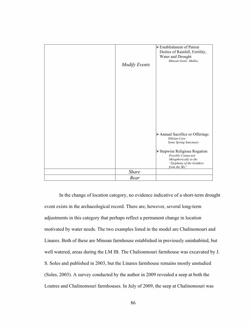
86
Modify Events
Establishment of Patron Deities of Rainfall, Fertility, Water and Drought
Minoan Genii: Mallia, Knossos, Phaistos
Annual Sacrifice or Offerings
Diktian Cave Syme Spring Sanctuary
Stepwise Religious Rogation Possibly Connected
Metaphorically to the “Epiphany of the Goddess from the Sky”
Share Bear
In the change of location category, no evidence indicative of a short-term drought
event exists in the archaeological record. There are, however, several long-term
adjustments in this category that perhaps reflect a permanent change in location
motivated by water needs. The two examples listed in the model are Chalinomouri and
Linares. Both of these are Minoan farmhouse established in previously uninhabited, but
well watered, areas during the LM IB. The Chalionmouri farmhouse was excavated by J.
S. Soles and published in 2003, but the Linares farmhouse remains mostly unstudied
(Soles, 2003). A survey conducted by the author in 2009 revealed a seep at both the
Loutres and Chalinomouri farmhouses. In July of 2009, the seep at Chalinomouri was

87
surrounded by lush vegetation in an otherwise desiccated landscape. The remains of
several structures flanked the spring and the rubble of more recent farmhouses abuts the
water feature. A garden is still kept and watered by the Chalinomouri spring today. The
seep itself is colonnaded by calcite columns, stalagmites, and stalactites. The spring at
Linares was less prodigious in the waxing summer heat of 2009, but wet columns of
calcium carbonate could still be recognized at the juncture of two different rock types.
The location of the Chalinomouri and Linares farmhouses in relation to other Minoan
sites of the same period is the most telling evidence of water need. Both farmhouses are
isolated at the far eastern end of the Mochlos plain. Though a single cultivator labors over
a garden plot at Chalinomouri today, they certainly do not live in the area. No one does.
This apparently holds true for the Bronze Age. In the 2009 survey, no other Minoan sites
were recognized between the farmhouses and the Mochlos quarry. The Chalinomouri and
Linares area was apparently as remote in the LM IB as it is today. The question naturally
arises, why would the Minoans choose this remote area in the LM IB over the places
between it and the main settlement at Mochlos? The far eastern end of the plain was
socially and economically remote. Understood as farmhouses, it could have been reasons
of better soil, if not for the fact that the soils surrounding the two farmhouses are identical
to the soils between the Mochlos site and there. The answer is likely water supply. None
of the other eight drainages between Mochlos and the eastern end of the plain have
springs, just those alongside Chalinomouri and Linares. The temporality of the two
farmhouses is also insightful in the context of this study. Both farmhouses were erected
in the LM IB and very little or no activity took place in the areas prior to this period.

88
Some Middle Minoan sherds were recovered within the context of Chalinomouri but do
not serve to date the main feature (Soles, 2003). These earlier sherds, however, are
suggestive of an interesting scenario. The area around Chalinomouri may have been
tended by a distant gardener during the Middle Minoan period, much like it is today. And
perhaps as the region became drier and drier, a fully realized farmhouse was constructed
next to the perennial trickle of the seep by the descendants of that original cultivator. The
two Minoan farmhouses lasted until the end of the LMIB and then went out of use. This
is a time when population declined sharply and a general nucleation of settlements
occurred on the island (MacDonald and Driessen, 1997).
Like the rural-urban shifts that took place in the Brazil example from the original
model, which were movements motivated by the expansion of the sub-tropical dry-season
in the northwest area of that country, Minoans may have moved towards more urban
areas in search of other work after their fields desiccated in the Neopalatial period. These
types of population shifts are very difficult to discern in the archaeological record in
general, and the motivations behind them are even more nebulous to modern observers.
That being stated, there appears to be some urban population growth during the LM IB
that is unparalleled at any other time and could possibly be related to drought inspired
migrations. Back at the site of Mochlos, an artisan community sprang up on the periphery
of the main settlement in the LM IB period (Soles, 2003). The laborers in this production
center may have been displaced farmers looking for other means of existence. If this was
in fact the case then they must have assisted a master crafts-person, for the quality of the
ceramics and other objects produced in the Artisan’s Quarter was superb. Evidence that a

89
Neopalatial drought or dry-spell motivated changes in location is uncertain at best,
though where it exists, it is more indicative of a long-term drying event than a short-term
drought. Changes in land-use during the Neopalatial period are much more tangible and
indicative of the environmental context of the time.
The examples of land-use change motivated by long-term drought in the model
are: 1) the creation of permanent irrigation works, 2) the conversion of agricultural areas
to other economic systems, and 3) the availability or development of crop varieties for
varying conditions. The third response leaves little or no evidence in the archaeological
record. The example of the second response is related to the type of change just
illustrated in the shifting function of the Artisan’s Quarter outside Mochlos, and lacks the
smoking gun of motivation. In other words, it is difficult to link a total use-conversion in
the ancient landscape to drought phenomenon. The first component in the model,
permanent irrigation works, do however produce direct evidence concerning the basic
hydrologic regime of an area and from there lend insight into the environmental context
around the said feature. Fortunately for the goal of this study, the morphology of the
typical Minoan irrigation network is very telling of the past precipitation inputs that
allowed it to function. Unlike other contemporary Bronze Age irrigation works in Egypt
and elsewhere, Minoan irrigation network did not function off of a perennial flowing
source of water, like the Nile. Instead the Minoan network appears to have been designed
to slow and capture periodic inputs of precipitation and store that moisture for as long as
possible. The evidence for this interpretation is presented below when the sites of Pseira
and Choiromandres are discussed; however, the point is this: the Minoan irrigation

90
network was designed to operate perfectly in a climate typified by a wet-season followed
directly by a prolonged dry-season. Therefore, the changes in land-use understood
through the creation of Neopalatial irrigation works not only indicates a long-term event
according to the model, it also describes the precipitation regime this event. The
precipitation regime the Minoan irrigation network describes is that of the Mediterranean
Climate. For that reason, the Minoan irrigation networks support the development of the
Mediterranean dry-season hypothesis over the random acute drought episode.
The Minoan town of Pseira is located on the southeast side of a precipitous island
that shares its name. The island of Pseira is situated along the northeast rim of the Bay of
Mirabello, Crete’s widest bay. The island is 2.36 km long and a little over a kilometer at
its widest. The majority of the island is comprised of crystalline limestone, the basement
rock of Crete. A Miocene deposit of marl, sandstone and conglomerate cap the highest
part of the island. A thick nappe of phyllite is draped over the eastern side of the island.
The west side of the island is nearly a uniform cliff-face that rises abruptly from the sea
to a maximum height of 200 m and then slopes to the east at roughly a thirty degree
angle. Pseira is incised with twelve drainages of various length and catchment area. The
largest and most developed of the drainages are located in the southeast section of the
island. Not coincidentally, this is the section of the island where human settlement has
concentrated.
91
CHAPTER X
THE PSEIRAN DAMS: MINOAN GEOLOGISTS AND HYDRAULIC ENGINEERS
The Minoan town of Pseira is located on the southeast side of a precipitous island
that shares its name. The island of Pseira is situated along the northeast rim of the Bay of
Mirabello, Crete’s widest bay. The island is 2.36 km long and a little over a kilometer at
its widest. The majority of the island is comprised of crystalline limestone, the basement
rock of Crete. A Miocene deposit of marl, sandstone and conglomerate cap the highest
part of the island. A thick nappe of phyllite is draped over the eastern side of the island.
The west side of the island is nearly a uniform cliff-face that rises abruptly from the sea
to a maximum height of 200 m and then slopes to the east at approximately a thirty
degree angle. Pseira is incised with twelve drainages of various length and catchment
area. The largest and most developed of the drainages are located in the southeast section
of the island. Not coincidentally, this is the section of the island where human settlement
has concentrated.
Water is scarce on Pseira. Today, the island is absolutely devoid of any life-giving
spring or seep. Only during the heavy rains of winter do rivulets barrel down the
drainages to the sea. The medieval period witnessed Pseira’s last human community. A
humble Byzantine monastery, dating to the late fifth to early sixth century, and two
farmhouses mark the finale of a settlement history that extended into the late Neolithic
period (Betancourt, 2005). In order to secure a reliable supply of freshwater, these hard-
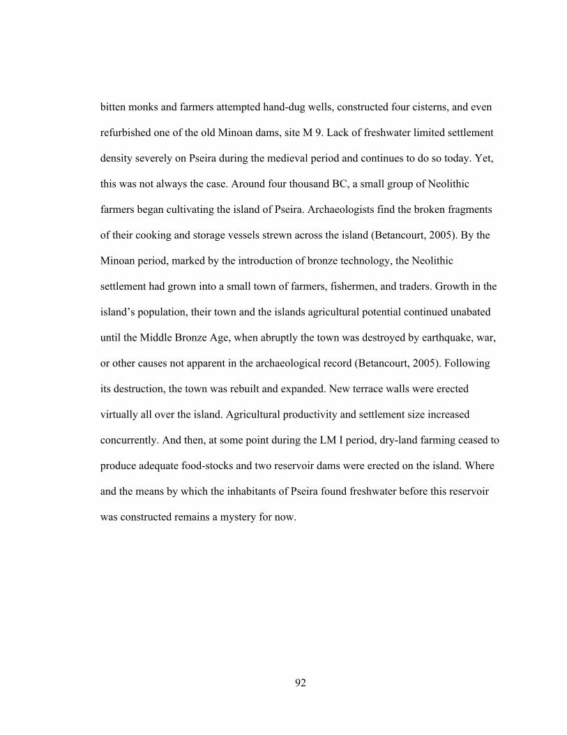
92
bitten monks and farmers attempted hand-dug wells, constructed four cisterns, and even
refurbished one of the old Minoan dams, site M 9. Lack of freshwater limited settlement
density severely on Pseira during the medieval period and continues to do so today. Yet,
this was not always the case. Around four thousand BC, a small group of Neolithic
farmers began cultivating the island of Pseira. Archaeologists find the broken fragments
of their cooking and storage vessels strewn across the island (Betancourt, 2005). By the
Minoan period, marked by the introduction of bronze technology, the Neolithic
settlement had grown into a small town of farmers, fishermen, and traders. Growth in the
island’s population, their town and the islands agricultural potential continued unabated
until the Middle Bronze Age, when abruptly the town was destroyed by earthquake, war,
or other causes not apparent in the archaeological record (Betancourt, 2005). Following
its destruction, the town was rebuilt and expanded. New terrace walls were erected
virtually all over the island. Agricultural productivity and settlement size increased
concurrently. And then, at some point during the LM I period, dry-land farming ceased to
produce adequate food-stocks and two reservoir dams were erected on the island. Where
and the means by which the inhabitants of Pseira found freshwater before this reservoir
was constructed remains a mystery for now.
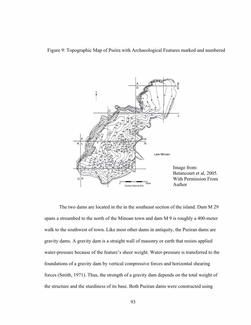
93
The two dams are located in the in the southeast section of the island. Dam M 29
spans a streambed to the north of the Minoan town and dam M 9 is roughly a 400-meter
walk to the southwest of town. Like most other dams in antiquity, the Pseiran dams are
gravity dams. A gravity dam is a straight wall of masonry or earth that resists applied
water-pressure because of the feature’s sheer weight. Water-pressure is transferred to the
foundations of a gravity dam by vertical compressive forces and horizontal shearing
forces (Smith, 1971). Thus, the strength of a gravity dam depends on the total weight of
the structure and the sturdiness of its base. Both Pseiran dams were constructed using
Image from: Betancourt et al, 2005. With Permission From Author
Figure 9: Topographic Map of Pseira with Archaeological Features marked and numbered
94
“Cyclopean” techniques. Cyclopean architecture consists of massive, undressed stones
fitted closely together without the use of mortar. Both dams were securely attached to the
bedrock with a packing of small stones and hard soil. The bedrock was cleaned of all soil
before construction began, the blocks were then emplaced and the earthen packing
material was crammed into the seams.
Dam M 9 has survived the ruins of time better than dam M 29. The M 9 dam
extends 15.5 m across an ephemeral streambed. The dam is 2.60 to 2.80 m thick where it
can be observed, but the excavators suggest that the center of the structure was likely 3.0
m wide or more during the Bronze Age (Betancourt, 2005). Dam is about 3.62 m in
height, which creates a catchment of roughly 500–600 cubic meters (600,000 liters). The
dam is primarily constructed with massive blocks of limestone, but some metacarbonate
rocks were noted as well (Betancourt, 2005). Limestone blocks were arranged into a
double-wall that ran perpendicular to the stream. The 1.5 m space between the double-
wall was filled with a packing of hard soil and small stones. The excavators noted that the
fill material was put in wet and rammed hard (Betancourt, 2005). Presumably, the “hard
soil” core consisted of clay or silt sized particles. Because of the minimal pore space
between grains of clay and silt, the hard soil core not only served to strengthen the
double-wall buttress structure, it made the dam wall impermeable.
Apart from being smaller and less well preserved, dam M 29 is very similar to
dam M 9. The structure consists of massive Cyclopean walls arranged into a double wall
with a soil and pebble packing crammed between. The bedrock was cleaned of all soil
material before the building blocks were attached. A mud and pebble mix was used as the

95
cementing agent to fix the blocks to the bedrock below. Dam M 29 is fitted and fastened
to a natural outcrop of limestone on its east end. The dam wall measures 11.85 m in
length. The highest preserved section measures 2.70 m but was likely higher at the time
of its construction. Wider than it is tall, the dam measures from 2.90 to 3.10 m in width.
With these dimensions, dam M 29 created a catchment capacity of 300-400 cubic meters
(400,000 liters), about two-thirds the capacity of dam M 9 (Betancourt, 2005). Although
smaller than dam M 9 in every respect, dam M 29 does have one unique feature: it
demonstrates the configuration of the entire catchment system, wherein the massive dam
structure is but a part of a network of features designed to operate in unison to control
and preserve both surface and groundwater. Preserved immediately below dam M 29
spans a series of five check-dams. The dams were placed at 10 m intervals and rise about
1.98 m high. Instead of creating reservoirs of standing water, each check-dam collected a
reservoir of soil and soil moisture. The deeper the soil-mantle behind the terrace-
wall/check-dam, the greater the potential soil moisture. Freshets rushing down the
watershed would slow and remain captured behind the main wall of dam M 29. Reducing
the flow regime in the lower reaches of the stream allowed the Minoans to stem the
surface and subsurface flow with thinner, easier to construct walls. Each check-dam had
only to slow and capture the flow for a 10 m segment of the catchment basin. Eventually,
each check-dam would have aggraded (filled in) and functioned more like a terrace wall
and less like a true check dam; however, until the streambed across which they were
stretched aggraded with soil, the structure would receive and stem streamflow like a true
dam.

96
Dam M 9 is also a part of a greater water-management system. Upstream from
dam M 9 stretches two carefully placed terrace walls. These terrace walls would have
reduced soil erosion above the dam, and thereby slowed the siltation rate of the M 9
reservoir (Betancourt, 2005).
The irrigation system on Pseira exhibits elements of both episodic flow systems
(designed to manage sporadic inputs of precipitation) and elements of long-term soil
moisture management systems (e.g., terraced agriculture, a crux of many ancient
agricultural societies). The element designed for episodic flow, the gravity dam, has
Bronze Age parallels elsewhere in the Near East (Wilkinson, 2003) but also on Crete.
Supporting the Neopalatial date for the arrival of the Mediterranean dry-season, all four
other examples of the use of stonewalls to control run-off date to the NeoPalatial period
(1700-1450 BC), if not specifically to the late NeoPalatial (1550-1450 BC) (Betancourt et
al. 2005, 262). The check-dams reported from the Kommos area (Shaw and Shaw, 1995),
from the Messara plain (Watrous et al. 1993), and from a watershed adjacent the Minoan
town of Gournia (Watrous et al. 2000) are little more than enlarged terrace-walls running
perpendicular to stream flow. The fourth example of a Minoan dam, however, is a
complete irrigation network like the system found on Pseira. Choiromandres was
originally reported as an isolated guardhouse, presumably positioned along a major
transport axis in the eastern end of the island, traces of the Minoan road have all but
vanished. Recent excavations, however, have uncovered a complex irrigation network
comprised of a gravity dam and subsidiary terrace walls below it. The archaeological
work at Choiromandres was completed under the auspices of Dr. Stella Chryssoulaki and

97
Christine Katsavou as a part of the Hydria Project; their results are published online
(http://www.hydriaproject.net/en/cases/crete). The similarities between the Pseiran
gravity and check-dam irrigation system and the Choiromandres irrigation network are
striking. First of all, both systems date to the same period, the Neopalatial. There is some
question surrounding the date of the main wall of the gravity-dam at the Choirmandres
site. Chryssoulaki dates the feature to either the end of the Old Palace period (1900-1700
BC) or to the beginning of the next, the New Palace period (1700-1430 BC). Curiously,
Chryssoulaki dates the check-dams downstream from the gravity-dam securely in the
NeoPalatial period. Further analysis of the gravity-dam will reveal the true date of its
construction. Besides the coinciding in date, the irrigation networks at Pseira and
Choiromandres exhibit the same arrangement of features. Both systems arrest the
overland flow of water by way of a gravity-dam, behind which water would pool to form
a reservoir of standing water. Scarborough (2003, 47) refers to this type of feature as a
storage dam. A series of terrace-walls/check-dams were placed below the gravity/storage
dam at both sites. At Pseira, the terrace-wall/check-dam sequence is arranged with a 10 m
spacing, whereas the Choirmandres spacing is closer to a 5 m interval (Betancourt, 2005).
Also, the first five terrace-walls/check-dams below the gravity-dam at Choiromandres
appears to have functioned to not only slow but also to direct overland flow downhill.
The terrace-walls/check-dams in the Pseiran system appear to have functioned primarily
to stop and detain the flow of water and not direct it downhill. The very last terrace-
wall/check-dam in the Choiromandres system is exceptionally long, extending over 200
meters. Chryssoulaki measured this wall to be 1.20 meters in width (2009). It is unclear

98
whether the last barrier wall in the Pseiran system was exceptionally long or not. The
geomorphological situation of the two sites, Pseira and Choiromandres, are quite
different and might explain the need for the elongated terminal check-dam in the
Choiromandres system and not in the Pseiran system. The Choirmandres ephemeral
stream would flow onto a small plain before continuing to the sea, while the streams on
Pseira (when they flow) flow directly into the sea. There are no plains on Pseira, only
slope. The similarities between the water-management systems emplaced at Pseira and
Choiromandres may represent a design standard for water-management systems
constructed in steeply sloping drainages. Further survey and excavation might reveal
other examples of the Neopalatial Irrigation Network found on the small island of Pseira
and at Choiromandres.
It is important to reiterate for the thesis of this paper that both the Pseiran and the
Choiromandres dams and their irrigation networks were designed ultimately to control
Image from: Chryssoulaki, 2009. www.hydriaproject.net
Figure 10: Dam and Channel Network at Choiromandres

99
and prolong soil moisture in order to increase crop yields and/or at least maintain yield
consistency. This implies that around the time these features were constructed, a growing
concern for soil moisture and crop yields was stirring in Minoan society. If it had not
been a major concern to the inhabitants of Pseira, the two enormous dams would not have
been laboriously erected. But as it were, apparently, the climate became drier in the
Neopalatial period than it had been in the earlier years of Minoan civilization. The
climatic drying was perhaps as acute as severe drought (1 to 3 years) or as long lasting as
a major shift in climate (100 to several thousand years). Evidence from the two irrigation
networks demonstrate that the development of the Mediterranean dry-season better
explains the water-management features present the archaeological record for this period.
The next theme in the model is the prevention of the negative effects of drought.
Like certain land-use changes, the human responses categorized in this theme often leave
significant traces in the archaeological record. This is certainly true for the Neopalatial
period. In an effort to mitigate the negative effects of drying climate during that period,
Minoans executed a number of adaptive strategies which included: 1) the creation of new
agricultural terraces and expansion of existing ones, 2) the creation of surface reservoirs,
3) the construction of domestic reservoirs (cisterns), 4) ceramic mulching of agricultural
fields, 5) the control and redistribution of floodwaters, 6) integration of water-
management into domestic architecture (related to cisterns), and 7) increased storage
capacity of food, fodder, and seed. Minoans may have also relied more heavily on marine
resources during the droughty summer months, but this is difficult to discern from the
zooarchaeological record. The development or continued practice of polyculture was
100
perhaps also an adaptive strategy employed by the Minoans, but this is difficult to
confirm. The palynological evidence confirms, however, that the right species for the
Mediterranean polyculture were on the island, but the way they were configured is
impossible to identify (Dickenson, 1994). It is also probable that facing drier condition,
Minoans began cultivating more hydrologically diverse plots. This is a common strategy
in both long and short-term droughts and seems like an obvious choice; however, traces
of cultivation quickly disappear with the progression of time and evidence for this
adaptive strategy is minimal. Perhaps the expansion of agricultural terraces on Pseira
during the Neopalatial period reflects this adjustment type of strategy. Central to this
study is near uniformity in adaptive responses for the prevention of effect theme that
reflect a long-term drying event with a high reoccurrence interval.
Terrace walls function in several ways, 1) they artificially flatten surfaces from
which crops are grown, 2) they deepen the soil, 3) they reduce soil erosion, and 4) they
manage soil moisture. The later function is of most interest here. Agricultural terraces
have been documented at numerous Minoan sites; however, terrace walls are notoriously
difficult to date. This is because when they are created, they are often filled with nearby
soil material, which could contain artifacts from various periods. Two Neopalatial
agricultural terrace systems have been dated with a high degree of certainty and will be
used to illustrate what might have been a wider-spread adjustment to the drying of the
Neopalatial climate. The sites are Pseira and Chalinomouri. At Chalinomouri, the terraces
abut a steep cliff overlooking the sea. Here the walls were probably emplaced to arrest
soils before they eroded into the sea below (Soles, 2003). The Chalinomouri terraces
101
would have also functioned to retained greater soil moisture. This function may have
been of particular interest for the Minoans who were cultivating that windy earthen ledge
where evaporation is rapid. Some of the terraces on Pseira have already been mentioned
in association with the dams, but is important to note that much of the island becomes
wrapped in terraces beginning in the Neopalatial period (Betancourt, 2005).
Minoans created their first surface water reservoirs during the Neopalatial period.
The Pseiran reservoirs are the most notable examples, but the dams at Gournia and near
the Chalinomouri farmhouse would have created notable impoundments. J. S. Soles
(2003, 104) reports that the Chalinomouri reservoir effectively wore a circular depression
into the surrounding terrain.
The Neopalatial period also marks the arrival of another soil water saving
technique besides agricultural terraces. There is evidence from Pseira that Minoans began
utilizing ceramic mulches in the Neopalatial period (Betancourt, 2005). This activity had
never been seen before on Crete or at any other site in the Aegean. This proactive
approach to soil water management would have effectively reduced evaporation and
surface runoff, increased infiltration rates and overall capacity in the soil, checked wind
speeds and eolian erosion, and provided additional surface area for water molecules to
adhere (Xiao-Yan Li, 2003).
Another proactive strategy enacted by the Minoans to cope with moisture
deficiency during the Neopalatial period was to slow floodwaters and store them in
deeply terraced soils. This type of adaptation is most striking at the Choiromandres site,
but the Pseiran network functioned similarly. This same type of long-term adaptation to

102
drought is practiced in the state of Oaxaca in southern Mexico (Kirkby, 1974). In Oaxaca,
farmers slow floodwaters by constructing several stone-walls (1-2 meters in height) that
channel the rushing water into a meander. The meandering floodwaters are then directed
into a small alluvial valley. The floodwater is then released from channelization and the
water surges over the soils and infiltrates along the way (Kirkby, 1974). Functionally, the
Oaxacan system is nearly identical to the Choiromandres irrigation network. It is
important to note that, similar to Crete, the rainfall distribution in Oaxaca is isolated into
one wet-season, which is then followed by a dry-season.
As mentioned in the geographic analysis section of this paper, the creation of
wells and cisterns greatly increased during the Neopalatial period. The list of sites with
wells and cisterns can be found in the model above. What is most important is the fact
that at a number of sites these features were only needed in the Neopalatial period and not
before. This indicates that water availability must have been greater in general, but also
more accessible locally at each of the respective site during the preceding periods. The
former ways of slaking thirst no longer sufficed in the Neopalatial period. The
adjustment-artifacts reflect that the change in environmental conditions was not a rapid
short-lived event, but rather a slower progression that gave Minoan society time to
integrate the necessary changes into their material culture.
103
CHAPTER XI
MINOAN WATER RITUAL DURING THE NEOPALATIAL PERIOD
The Minoans, like many other societies since, likely appealed to supernatural
forces to affect the changing environmental conditions of the Neopalatial period in a way
that favored their wants. The ethnographic base for this model demonstrated that prayer
was the most ubiquitous response to drought in the twentieth century AD. There exists
some evidence that the Neopalatial concern over water entered Minoan religion. The
connection can be drawn using two pieces of information. The first is from the site of
Mochlos where water is displayed in religious building that dates solely to the LM IB
period. The second suggestive piece of the information is the adoption of a new water
deity into the Minoan pantheon during the Neopalatial period.
Water is the most precious resource humans can control and it affects everyone
each and every day. Every major world religion has some sort of water ritual
(Scarborough, 2003). It is baptism in the Christian faiths and washing before prayers in
Islam. In fact, all societies have performed water rituals (Scarborough, 2003). Ritual, as
an idea, is predisposed to incorporate water into it. This is because rituals, unlike beliefs,
symbols, or myths, are habitual actions that publically define an ideology (Scarborough,
2003). Rituals, in order to unite the various classes of people in a hierarchical society,
must draw inspiration from mundane behaviors that transcend the social structure, such
as the everyday uses of water (Scarborough, 2003). Again, both Muslims and Christians
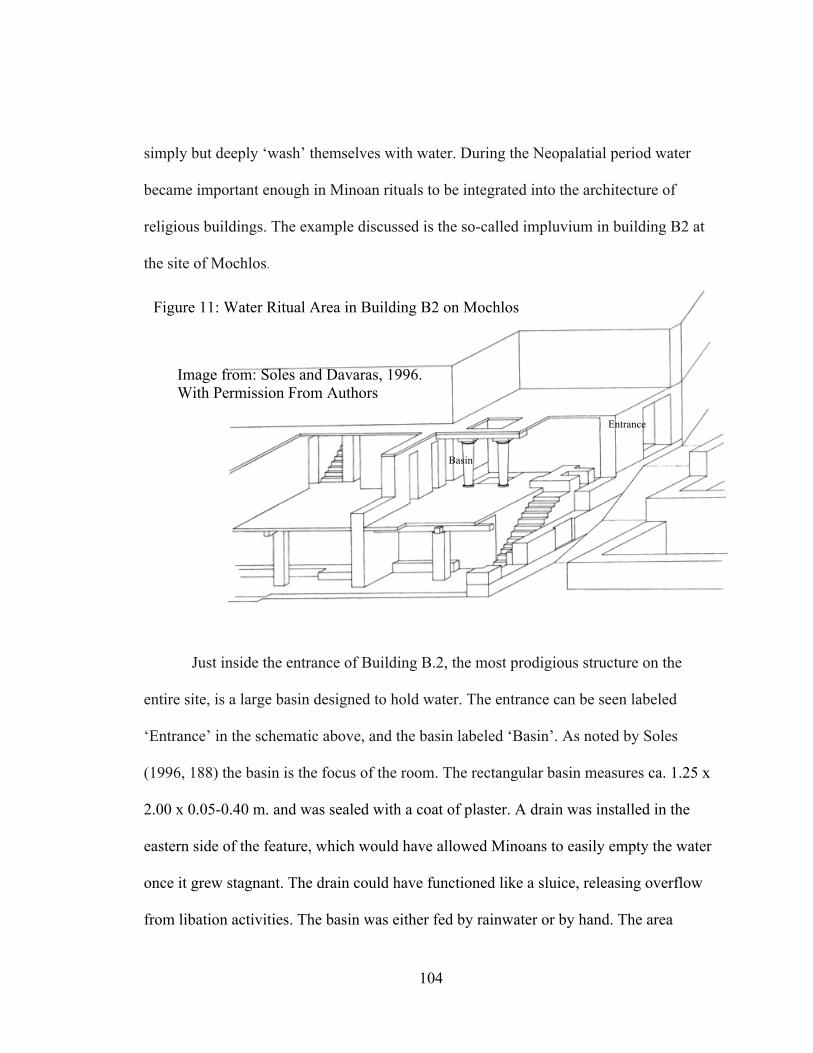
104
simply but deeply ‘wash’ themselves with water. During the Neopalatial period water
became important enough in Minoan rituals to be integrated into the architecture of
religious buildings. The example discussed is the so-called impluvium in building B2 at
the site of Mochlos.
Just inside the entrance of Building B.2, the most prodigious structure on the
entire site, is a large basin designed to hold water. The entrance can be seen labeled
‘Entrance’ in the schematic above, and the basin labeled ‘Basin’. As noted by Soles
(1996, 188) the basin is the focus of the room. The rectangular basin measures ca. 1.25 x
2.00 x 0.05-0.40 m. and was sealed with a coat of plaster. A drain was installed in the
eastern side of the feature, which would have allowed Minoans to easily empty the water
once it grew stagnant. The drain could have functioned like a sluice, releasing overflow
from libation activities. The basin was either fed by rainwater or by hand. The area
Entrance
Basin
Image from: Soles and Davaras, 1996. With Permission From Authors
Figure 11: Water Ritual Area in Building B2 on Mochlos

105
surrounding the basin was eloquently paved with slabs of various colors. A triangular
slab of purple schist was marked with shallow perforations in a circular pattern. This type
of decorated slab is known as a kernos in Minoan archaeology and is associated with
libation water rituals. The purple kernos is located at the central access point on the south
side of the basin. Several Minoan cups were found in the drain basin, likely washed there
when the feature was drained for the very last time. The cups are LM IB in date (Soles
and Davaras, 1996).
The so-called ‘Minoan Genii’ or ‘Water Genius’ entered Minoan iconography
sometime during the Neopalatial period. It is depicted on several seal-stones from
Knossos, Phaistos, and Malia that roughly date to the early Neopalatial (Weingarten and
Hallager, 1993). The Genius has been linked to the Egyptian goddess Taweret, which is
most often depicted as an anthropomorphized female hippopotamus, but occasionally
dons a lion’s head (Weingarten and Hallager, 1993). In Minoan iconography, the Genius
forever holds a high-necked single-handled ewer. This vessel can be seen in the image
below. With already mentioned examples of water deities and patron saints of both
drought and rainfall from contemporary religions, it seems very plausible that the Water
Genius could have functioned in a similar way for the Minoans. During particularly dry
dry-seasons, perhaps the Minoans entreated a little rain from the heavens above, or
wherever the Water Genius resided.
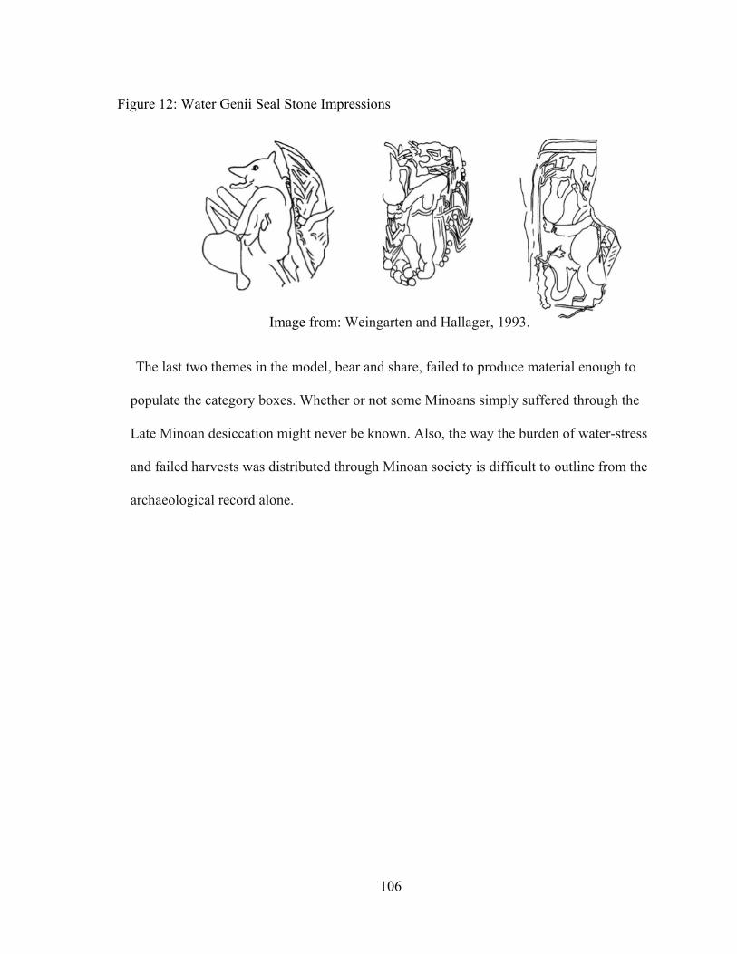
106
The last two themes in the model, bear and share, failed to produce material enough to
populate the category boxes. Whether or not some Minoans simply suffered through the
Late Minoan desiccation might never be known. Also, the way the burden of water-stress
and failed harvests was distributed through Minoan society is difficult to outline from the
archaeological record alone.
Image from: Weingarten and Hallager, 1993.
Figure 12: Water Genii Seal Stone Impressions
107
CHAPTER XII
CONCLUSIONS
The goal of this study was to determine which of two hypotheses best described
the type of drought event that inspired the water-management features apparent in the
archaeological record for the Neopalatial period. The proposed hypotheses were from two
schools of research, archaeology and paleoecology. Archaeologists suggested that the
Neopalatial water-management features were the result of a major short-term drought
episode that disrupted social stability on Crete and elsewhere in the Eastern
Mediterranean. Not in any way motivated to explain the need for Minoan water-
management, paleoecologists suggested that the climate known today as Mediterranean
developed gradually on Crete during the Aegean Bronze Age. Pollen cores from Crete
provided the main source of paleoecological data from which this hypothesis was based;
however, a total gap in coverage from the pollen cores exists for the Neopalatial Period.
This lack of coverage makes both hypotheses viable, even though they differ markedly.
Understanding the development of the Mediterranean climate has much larger
implications than dating an acute but ephemeral drought. Lacking the means and
wherewithal to simply core another location on Crete, this study utilized the behaviors
apparent in the archaeological record to tease out the particulars of the Neopalatial drying
event. The determining factor between the two hypotheses is essentially time. One is a
weather phenomenon, the other climate, and the difference between the two is duration

108
and periodicity. The key to this study was determining what types of artifacts reflect
long-term versus short-term drought phenomenon. To this end, a model was constructed
from various ethnographic sources. The one site where human interaction with the local
hydrogeology could be observed was used to simply confirm that severe water shortages
affected Crete during the Neopalatial period. That site was Palaikastro. After the
magnitude of the drying event was elucidated, the distribution of Minoan adjustment-
artifacts was analyzed spatially in order to understand the areal extent and the dispersion
of the effect across the island. This analysis demonstrated that several patterned gradients
exist in the distribution of waterworks and that these patterns are best explained by the
development of the Mediterranean dry-season hypothesis. To clarify other temporal
aspects of the drought event, the Minoan adaptations to drought were analyzed against
the framework created in the drought response model. In this section, the short and long-
term responses from the ethnographic literature were removed and replaced when
possible with the long and short-term Minoan responses to drought. The results
overwhelmingly indicated that the dry conditions that motivated the Minoan water-
management features was the development and intensification of the Mediterranean dry-
season.
The results of this study indicate that the Mediterranean dry-season became more
pronounced on Crete during the Neopalatial period. The Late Minoan IB was perhaps a
particularly dry period with more pronounced summer temperatures or perhaps less
winter precipitation. This position is supported by an increase in the scale of Minoan
water-management features during the LM IB, especially in the eastern third of the

109
island. It appears that plant communities on Crete had responded to the changing climatic
conditions sometime during the Middle Bronze Age; human communities eventually
responded to the same climatic change in the Neopalatial period.

110
REFERENCES Bennett, J. W. 1976. Anticipation, adaptation, and the concept of culture in anthropology.
Science, 192. 847-853
Betancourt, P. 2005. Pseira IX: The Archaeological Survey of Pseira Island Part 2. Philadelphia, PA: INSTAP Academic Press.
Bolle, H. 2003. Mediterranean Climate: variability and trends. New York, NY: Springer Bottema, S. 1980. Palynological Investigations on Crete. Review of Palaeobotany and
Palynology, 31. 193-217 Burton, I., Kates, R. and White, G. F. 1993. The Environment as Hazard. New York, NY:
Guilford Press. Butzer, Karl. 1982. Archaeology as Human Ecology. New York, NY: Cambridge
University Press. Chryssoulaki, S. 2009. Water Management in Prehistoric Crete: The case of
Choiromandres, Zakros. Published at http://www.hydriaproject.net. Diamond, J. 2005. Collapse: How Societies Choose to Collapse or Succeed. New York,
NY: Penguin Press Dickenson, O. 1994. The Aegean Bronze Age. Cambridge, UK: Cambridge University
Press. Dingman, S. L. 2002. Physical Hydrology. Upper Saddle River, NJ: Prentice Hall. Driessen, J., and C. MacDonald. 1997. The Troubled Island: Minoan Crete Before and
After the Santorini Eruption. Belgium: KLIEMO Press. Driessen, J. 2002. Towards an Archaeology of Crisis: defining the long-term impact of
the Bronze Age Santorini eruption. In Natural Disasters and Cultural Change, edited by Torrence, R. and Grattan, J.. New York, NY: Routledge Press.
Dupree, H. and W. Roder. 1974. Coping with Drought in a Preindustrial, Preliterate
Farming Society. In Natural Hazards: Local, National, Global, edited by G. F. White, pp. 155-199. London, UK: Oxford University Press.

111
Dunning, N., T. Beach, P. Farrell, and S. Luzzadder-Beach. 1998. Prehispanic Agrosystems and Adaptive Regions in the Maya Lowlands, Culture and Agriculture 20 (2/3): 87-101
Fagan, B. 2004. The Long Summer: How Climate Changed Civilization. New York, NY:
Basic Books Publishers. Galili C. and Y. Nir. 1992. The submerged Pre-Pottery Neolithic water well of Atlit-Yam,
northern Israel, and its palaeoenvironmental implications. Jerusalem: Geological Survey of Israel.
Gifford, J. 1992. The Geomorphology of Crete. In Aerial Atlas of Ancient Crete, edited
by J.W. Myers, E.E. Myers, and J. Gifford, pp 17-27. Berkley, CA: University of California Press.
Goodfriend, G. 1991. Holocene Trends in 18O in Land Snail Shells from the Negev
Desert and Their Implications for Changes in Rainfall Source Areas. Quaternary Research 35: 417-426.
Grove, A. T. and O. Rackham. 2001. The Nature of Mediterranean Europe: An
Ecological History. New Haven, CT: Yale University Press. Hankins, T. 1974. Response to Drought in Sukumaland, Tanzania. In Natural Hazards:
Local, National, Global, edited by G. F. White, pp. 98-104. London, UK: Oxford University Press.
Harrison, S. and G. Digerfeldtt, G.1993. European Lakes as Palaeohydrological and
Palaeoclimatic Indicators. In Quaternary Science Reviews, Vol. 12, pp. 233-248. Heijen J. and R.W. Kates. 1974. Northeast Tanzania: Comparative Observations Along a
Moisture Gradient. In Natural Hazards: Local, National, Global, edited by G. F. White, pp. 105-144. London, UK: Oxford University Press.
Hempel, L. 1990. Forschungen zur Physischen Geographie der Insel Kreta im Quartär.
Vandenhoeck and Ruprecht, Gottingen. Hitchcock, L. 2000. Minoan Architecture: A Contextual Analysis. Sweden: Elanders
Publishing. Hood, M. S. F., 1966. The Early and Middle Minoan periods at Knossos. BICS 13: 110-
11. Hugget, R. J. 2007. Fundamentals of Geomorphology. New York, NY: Routledge Press.

112
Isendahl, N. 2006. Drought in the Mediterranean: WWF Policy Proposals. Madrid: World Wide Fund for Nature Press.
Kirkby, A. 1974. Individual and Community Response to Rainfall Variability in Oaxaca,
Mexico. In Natural Hazards: Local, National, Global, edited by G. F. White, pp. 119-128. London, UK: Oxford University Press.
Lawson, J. C., 1910. Modern Greek Folklore and Ancient Greek Religion: A Study in
Survivals. Cambridge: University Press. Li, Xiao-Yan. 2002. Gravel–sand mulch for soil and water conservation in the semiarid
loess region of northwest China. In Catena, 52 (2003) pp. 105–127. MacGillivray, J.A., L.H. Sackett, and J. Driessen. 2007. Palaikastro: Two Late Minoan
Wells. Volume 43 of Supplementary Volume of the British School at Athens, Athens.
Moody, J. 1997. The Cretan Environment: Abused or Just Misunderstood? In Aegean
Strategies: Studies of Culture and Environment on the European Fringe, edited by Kardulias, P. N. and M. Shutes. Boulder, CO: Rowman & Littlefield Publishers, Inc.
Morris, M. 2002. Soil Science and Archaeology: Three Test Cases from Minoan Crete.
Philadelphia, PA: The Institute for Aegean Prehistory Academic Press. Mortimore, M. 1989. Adapting To Drought: Farmers, famines & desertification in West
Africa. Cambridge, UK. Cambridge University Press. Pendlebury, J. D. S. 1965. The Archaeology of Crete: An Introduction. New York, NY:
W.W. Norton Company, Inc. Perry, A. 1997. Mediterranean Climate. In The Mediterranean: Environment and Society,
edited by King, R., Proudfoot, L., and Smith, B. pp. 30-42. London, UK: Hodder Headline Group.
Pfister, C. 2009. Learning from Nature-Induced Disasters: Theoretical Considerations
and Case Studies from Western Europe. In Natural Disasters, Cultural Responses: Case Studies Toward a Global Environmental History, edited by Mauch, C. and Pfister, C. London, UK: Lexington Books.
Platon, N. 1971. Zakros: The Discovery of a Lost Palace of Ancient Crete. New York,
NY: Charles Scribner’s Sons.

113
Rackham, O. and J. Moody. 1996. The Making of the Cretan Landscape. Manchester, UK: Manchester University Press.
Rapp, G. R. and C. Hill. 2006. Geoarchaeology: The Earth Science Approach to
Archaeological Interpretation. New Haven, CT: Yale University Press. Reycraft, R. M. 2000. Introduction: Environmental Disaster and the Archaeology of
Human Response. In Environmental Disaster and the Archaeology of Human Response, edited by G. Bawden and R. M. Reycraft. pp. 1-11. Albuquerque, NM: The Maxwell Museum of Anthropology Press.
Roberts, D. 1996. Geology: Eastern North America. New York, NY: Peterson Field
Guides. Rosen, A. M. 2007. Civilizing Climate: Social Responses to Climate Change in the
Ancient Near East. Lantham, NY: Altamira Press. Rosenbaum, G., G. Lister, C. Duboz. 2002. Relative motions of Africa, Iberia and Europe
during Alpine orogeny. Tectonophysics 359: 117-129. Rossi, G., A. Cancelliere and G. Giuliano. 2006. Role of decision support system and
multicriteria methods for the assessment of drought mitigation measures. In Drought Management and Planning for Water Resources. Edited by Andreu, J. and Rossi, G. New York, NY: Taylor & Francis Group.
Ruffel, A. 1997. Geological Evolution of the Mediterranean Basin. In The
Mediterranean: Environment and Society, edited by King, R., Proudfoot, L., and Smith, B. pp. 12-28. London, UK: Hodder Headline Group.
Scarborough, V. 2003. The Flow of Power: Ancient Water Systems and Landscapes.
Santa Fe, NM: School of American Research Press. Shaw J. W., and M. Shaw. 1995. Kommos: An Exacavation on the South Coast of Crete,
Volume I: The Kommos Region and Houses of the Minoan Town. Princeston, NJ: Princeton University Press.
Smith, B. 1997. Water: A Critical Resource. In The Mediterranean: Environment and
Society, edited by King, R., Proudfoot, L., and Smith, B. pp. 227-250. London, UK: Hodder Headline Group.
Smith, N. 1971. A History of Dams. London, UK: Peter Davies Books.

114
Soles, J. S. 2003. Mochlos IA, Period III. Neopalatial Settlement on the Coast: The Artisans’ Quarter and the Farmhouse at Chalinomouri. Philadelphia, PA: INSTAP Academic Press.
Soles, J. S. and C. Davaras, C. 1996. Excavations at Mochlos, 1992-1993. Hesperia, Vol.
65, No. 2 (Apr. - Jun., 1996), pp. 175-230. Athens, GR: American School of Classical Studies at Athens Press.
Tarbuck, E. and Lutgens, F. 2008. Earth: An Introduction to Physical Geology. Upper
Saddle River, NJ: Pearson Prentice Hall. Thorne, S. M., 2007. Well 576: excavation and stratigraphy. Palaikastro: Two Minoan
Wells edited by MacGillivray, Sackett, and Driessen. The British School at Athens. Supplementary Volumes, No. 43. 9-15.
Wilkenson, T. J. 2003. Archaeological landscapes of the Near East. Tuscon, AZ: The
University of Arizona Press. Hensberg, H. V. 1968. Der Primarebau der Angiospermenwurzel. Berlin: Gerbruder Borntrager. Varner, G. 2009. Sacred Wells: A study in the History, Meaning, and Mythology of Holy
Wells and Waters. New York, NY: Agora Publishing. Vita-Finzi, C. 1978. Archaeological Sites in Their Setting. London, UK: Thames and
Hudson Press. Watrous, L., X. Vallianou, K. Pope, T. Mourtzas, J. Shaw, C. Shaw, J. Bennet, D.
Tsoungarakis, E. Angelomati-Tsoungarakis, C. Christophoros. and Blitzer. 1993. A Survey of the Western Mesara Plain in Crete: Preliminary Report of the 1984, 1986, and 1987 Field Seasons. Hesperia, Vol. 62, No. 2 (Apr. - Jun., 1993), pp. 191-248.
Watrous, L. 1982. Lasithi: A History of Settlement on a Highland Plain in Crete. Hesperia:
Supplement XVIII. Princeton, N.J. Weingarten, J. and Hallager, E. 1993. The Five Roundels from Malia, with a Note on
Two New Minoan Genii. Bulletin de correspondance hellenique. Volume 117, livaison 1, 1993, pp. 1-18.
Wilhite, D., M. Buchanan-Smith. 2005. Drought as Hazard: Understanding the Natural
and Social Context. Drought and Water Crises: Science, Technology, and Management Issues, edited by D. Wilhite. pp. 4-27. CRC Press.

115
White, G. F. 1974. Natural Hazards Research: Concepts, Methods, and Policy Implications. In Natural Hazards: Local, National, Global, edited by G. F. White, pp. 3-16. London, UK: Oxford University Press.
Wilson, J. 1951. The Culture of Ancient Egypt. Chicago, IL: The University of Chicago
Press. Yordanov, I., V. Velikova, T.Tsonev. 2003. Plant Response to Drought and Stress
Tolerance. BULG. J. Plant Physiol., Special Issue, 197-206.


