Download - Final Interactive Proj.study

8/3/2019 Final Interactive Proj.study
http://slidepdf.com/reader/full/final-interactive-projstudy 1/49
Our Lady of Lourdes College Foundation
Interactive Map of Camarines Norte
INTERACTIVE MAP OF CAMARINES NORTE
SYSTEM ANALYSIS AND DESIGN
Presented to
The Faculty of Our Lady of Lourdes College Foundation
In Partial Fulfilment
Of the Requirements of
System Analysis and Design
ABUNDO, VIA MONICCA
BARLINTANGCO, ALVIN
CAMACHO, JULIET
ESPINAS, RICHELLE
MR. DARIO GALEON, MCS
Adviser
March 2011

8/3/2019 Final Interactive Proj.study
http://slidepdf.com/reader/full/final-interactive-projstudy 2/49
Our Lady of Lourdes College Foundation
Interactive Map of Camarines Norte

8/3/2019 Final Interactive Proj.study
http://slidepdf.com/reader/full/final-interactive-projstudy 3/49
Our Lady of Lourdes College Foundation
Interactive Map of Camarines Norte
8/3/2019 Final Interactive Proj.study
http://slidepdf.com/reader/full/final-interactive-projstudy 4/49
Our Lady of Lourdes College Foundation
Interactive Map of Camarines Norte
PROJECT STUDY ABSTRACT
This study aimed to designed and developed web based
interactive map of Camarines Norte. Specifically, the
following questions were answered: (1) What are the key
features of interactive map that will provide quality of
service? (2) What are the processes in a manual interactive
map? (3) What are the processes identified that can be adopted
in an interactive map? (4) What security measure can be
adopted in an interactive map?
This study utilized the Structured Systems Analysis and
Design Method (SSADM). Document analysis was the main
instrument used to gather data. Internet browsing and library
research were also applied.
It was concluded that (1) Interactive map has become a
necessity everywhere. Interactive Map of Camarines Norte
provides the quality of service to the visitors by easy
navigation in finding locations or places and gets an overview
in the entire place. (2) (3) and (4) E-trust should be adopted
by interactive map of Camarines Norte for security and privacy
of the visitors.
Based on the conclusions formulated, the following are
recommended: (1); (2);
8/3/2019 Final Interactive Proj.study
http://slidepdf.com/reader/full/final-interactive-projstudy 5/49
Our Lady of Lourdes College Foundation
Interactive Map of Camarines Norte
ACKNOWLEDGMENT
The researchers were greatly inspired by the wonderful
and pleasant experience they enjoyed during their college days
doing this work. They sincerely express their heartfelt
gratitude and due acknowledgment for the moral support extends
to them by the following:
Mr. Richard E. Dilan MIT, Thesis Adviser, for his
wholehearted support and assistance in the completion of this
study;
Mr. Gerry P. Lopez MCS, Dean of Computer Studies, for his
pieces of advice and moral support;
Mr.Dario Galeon MCS, Thesis Instructor, for his guidance
extended to the researchers;
, for going through manuscript, editing and rewriting;
Our family, for their inspiration, financial and
wholehearted support;
Above all, to the Almighty God who is the source of all
goodness in the world. For all the blessings bestowed upon
then and who make things possible.
8/3/2019 Final Interactive Proj.study
http://slidepdf.com/reader/full/final-interactive-projstudy 6/49
Our Lady of Lourdes College Foundation
Interactive Map of Camarines Norte
DEDICATION
To God Almighty,
For His Love and Blessings and for giving us enough strength
and patience;
To our family, friends, love one’s and future researcher.
THIS PIECE OF WORK IS HEARTILY DEDICATED.
THE RESEARCHERS

8/3/2019 Final Interactive Proj.study
http://slidepdf.com/reader/full/final-interactive-projstudy 7/49
Our Lady of Lourdes College Foundation
Interactive Map of Camarines Norte
TABLE OF CONTENTS
TITLE
APPROVAL SHEET
PROJECT STUDY ABSTRACT
ACKNOWLEDGMENT
DEDICATION
TABLE OF CONTENTS
LIST OF FIGURE
CHAPTER I - PROJECT OVERVIEW
Background of the Study
Importance of the Study
Statement of the Problem
Objectives of the Study
Definition of Terms
CHAPTER II - METHODOLOGY
Software Development Methodology
Scope and Delimitation
Data Gathering Techniques
Sources of Data
CHAPTER III - DISCUSSION OF FINDINGS
The key features of interactive map that will
provide quality of service
The process in a manual interactive map
The processes identified that can be adopted in an
interactive map
The security measures that can be adopted in an
8/3/2019 Final Interactive Proj.study
http://slidepdf.com/reader/full/final-interactive-projstudy 8/49
Our Lady of Lourdes College Foundation
Interactive Map of Camarines Norte
interactive map
CHAPTER IV - SUMMARY, CONCLUSIONS AND RECOMMENDATIONS
Summary
Conclusions
Recommendations
REFERENCES
APPENDICES
A. Entity Relationship Diagram of the Proposed SystemB. Use Case Diagram of the Proposed System
C. Database of the Proposed System
D. Hardware and Software Specifications
E. Screenshots of the Proposed System
CURICCULUM VITAE
8/3/2019 Final Interactive Proj.study
http://slidepdf.com/reader/full/final-interactive-projstudy 9/49
Our Lady of Lourdes College Foundation
Interactive Map of Camarines Norte
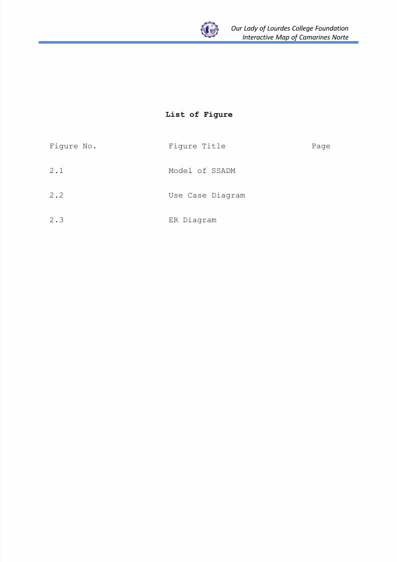
List of Figure
Figure No. Figure Title Page
2.1 Model of SSADM
2.2 Use Case Diagram
2.3 ER Diagram

8/3/2019 Final Interactive Proj.study
http://slidepdf.com/reader/full/final-interactive-projstudy 10/49
Our Lady of Lourdes College Foundation
Interactive Map of Camarines Norte
CHAPTER I
Project Overview
Background of the Study
Visual representation of an area and relationships
between elements of that space such as objects, regions,
and themes. The process of sourcing maps and identifying
appropriate tools for an interactive map-making.
Interactive map is often practice of crafting
representations of the Earth upon a flat surface. According
toMap Division at The New York Public Library (Wikipedia,
2010) many maps are static two-dimensional, geometrically
accurate representations of three-dimensional space, while
others are dynamic or interactive, even three-dimensional.
Although most commonly used to depict geography, maps may
represent any space, real or imagined, without regard
to context or scale. It is critical for every country to
resort to means that offer quality and accurate interactive
map solutions at competitive cost. There are plenty of
interactive map sites available online - including Google Map,
Yahoo Map, Bing Map, Microsoft MapPoint, MapQuest, and many

8/3/2019 Final Interactive Proj.study
http://slidepdf.com/reader/full/final-interactive-projstudy 11/49
Our Lady of Lourdes College Foundation
Interactive Map of Camarines Norte
more. They are mainly used as directions tools, for road
mapping and route planner. Information about how to get there.
Interactive map making software usually supports custom
definable regions, areas and location points.
Interactive map
An image map is usually a picture (e.g. a photo, a
diagram, a chart, or a floor plan) with single or multiple
clickable hot spots. Clicking on the hot spots will let
browsers see more information in a pop-up box, or link to
other online destinations. These maps are for navigation or
data representation purpose, geographical details such as
highways, buildings, rivers are not always necessary, which
makes the map cleaner and easier to navigate by visitors. With
few click-through on the national, state or county map,
visitors can quickly find information or be redirected to
specific page about a particular location on the map image.
Image maps allow web designers to be more creative in terms of
visual effects and website navigation. if you are organizing a
trade show or exhibition, you can use an image map to display
your exhibition floor plan, and allow browsers to see each
exhibitor's details by hover over their mouse pointer on a
booth, a logo or a descriptive text, with a link to the home
page of the selected exhibitor.
Image maps make information on your website more
accessible, which encourage customers to keep coming back to
8/3/2019 Final Interactive Proj.study
http://slidepdf.com/reader/full/final-interactive-projstudy 12/49
Our Lady of Lourdes College Foundation
Interactive Map of Camarines Norte
the page and can improve website’s conversion ratio. When
people browsing information online, they often respond to
visual and interactive elements faster. An image map helps
visitors to find information as they do not need to read lots
of text in order to find the page they want. Most image maps
are coded using Java script, HTML, and hot spots are defined
by using x and y coordinates. Instead, they look at a self-
explanatory image, and click on the item or element which
interested them the most. This in turn makes it easier to
convert visitors into potential visitors. If you are in the
business of selling furniture, you could put a large image of
a fully furnished apartment on your home page. By rolling the
cursor over certain objects, such as the chair, users will
find that they can actually click on the chair and it will
take them to the related page where they can find a collection
of chairs for them to find more information easily.
Unstructured Map Making
Visual indication of the earth's surface, the shape of
the continents, and their relative positions, and gives a true
representation; whatever position it is viewed from. The shape
and size of the various continents is not distorted through
trying to represent a spherical surface on a flat piece of
paper. However; globes cannot give detailed information on a
large scale; even very large globes. They also give a false
impression of the relative curvature of the earth, because the
8/3/2019 Final Interactive Proj.study
http://slidepdf.com/reader/full/final-interactive-projstudy 13/49
Our Lady of Lourdes College Foundation
Interactive Map of Camarines Norte
radius of a globe is a lot less than the radius of the earth.
Maps on the other hand can be produced at any scale desired;
and the larger the scale, the less the effect of distortion.
Maps can provide detailed information and provide
topographical data in much more detail that a globe. Maps are
easier to prepare, and can be modified as physical or
political situations change (road maps, for example) However;
all maps distort the shape or size of landforms; particularly
on a global scale. They either distort the shape of the land,
or the relative size of the continents. “Greenland may appear
to be the same size as Africa on a global map, but it is in
fact a lot smaller.”
Requirements of a map include the selection of various
features which are to be included on the map, the
characterization of these features into groups such as ―Roads‖
or ―built-up areas,‖ the simplification of detailed outlines
of areas including the coastline, the exaggeration of some
features on the map that are often too small in reality to
represent, and the use of symbols to classify the different
classes of the chosen features for the map. To interpret most
symbols and features, a representative key is usually
supplied. Without a good knowledge of the many symbols on a
map, it is often difficult to find what you are looking for in
a short space of time. Other disadvantages of basic maps is
that they are also often stylized, meaning that they are often

8/3/2019 Final Interactive Proj.study
http://slidepdf.com/reader/full/final-interactive-projstudy 14/49
Our Lady of Lourdes College Foundation
Interactive Map of Camarines Norte
portrayed in an unnatural way, and require some level of
interpretation. Maps are often out of date because they have
to be printed and therefore the date of publication is the
latest date of accuracy. They also show only a situation that
is static and is a reflection of one section in time only.
Some maps are very artistic which can make them more difficult
to interpret, and area on a map can be rather difficult to
determine accurately. It becomes increasingly difficult to use
a map of the area if you are positioned on top of a high
location within the map location as perspectives change and
some objects are blocked from view by other objects. Maps
cannot pan or give an oblique angle view on the map location.
Due to the cost of producing and making certain maps, the
information that they contain is often a compromise with what
can be afforded.
Cartography Technological Changes
Technology has continually changed in order to meet the
demands of new generations of mapmakers and map users. The
first maps were manually constructed with brushes and
parchment; therefore, varied in quality and were limited in
distribution. The advent of magnetic devices, such as the
compass and much later, storage devices, allowed for the
creation of far more accurate maps and the ability to store
and manipulate them digitally. Advances in mechanical devices
such as the printing press, quadrant and vernier, allowed for

8/3/2019 Final Interactive Proj.study
http://slidepdf.com/reader/full/final-interactive-projstudy 15/49
Our Lady of Lourdes College Foundation
Interactive Map of Camarines Norte
the mass production of maps and the ability to make accurate
reproductions from more accurate data. Optical technology,
such as the telescope, sextant and other devices that use
telescopes, allowed for accurate surveying of land and the
ability of mapmakers and navigators to find their latitude by
measuring angles to the North Star at night or the sun at
noon. Advances in photochemical technology processes allowed
for the creation of maps that have fine details, do not
distort in shape and resist moisture and wear. This also
eliminated the need for engraving, which further shortened the
time it takes to make and reproduce maps. According to
(Wikipedia, 2010) advances in electronic technology in the
20th century ushered in another revolution in cartography.
Ready availability of computers and peripherals such as
monitors, plotters, printers, scanners (remote and document)
and analytic stereo plotters, along with computer programs for
visualization, image processing, spatial analysis, and
database management, have democratized and greatly expanded
the making of maps. The ability to superimpose spatially
located variables onto existing maps created new uses for maps
and new industries to explore and exploit these potentials.
These days most commercial-quality maps are made using
software that falls into one of three main types: CAD, GIS and
specialized illustration software. Spatial information can be
stored in a database, from which it can be extracted on
demand. These tools lead to increasingly dynamic, interactive
8/3/2019 Final Interactive Proj.study
http://slidepdf.com/reader/full/final-interactive-projstudy 16/49
Our Lady of Lourdes College Foundation
Interactive Map of Camarines Norte
maps that can be manipulated digitally. While originally a
military project, GPS is considered a dual-use technology,
meaning it has significant military and civilian applications.
GPS has become a widely deployed and useful tool for commerce,
scientific uses, tracking, and surveillance. GPS's accurate
time facilitates everyday activities such as banking, mobile
phone operations, and even the control of power grids by
allowing well synchronized hand-off switching. Farmers,
surveyors, geologists, and countless others perform their work
more efficiently, safely, economically, and accurately.
Web Enable Interactive mapping promotes Economic Benefits
For the majority of us, maps represent a useful tool
which we often use in daily life be it while navigating new
hiking trails or when we are looking for a specific landmark,
shopping centre or street name in an unfamiliar town or city.
The common road atlas is now being replaced with more
sophisticated and interactive digital forms which in some
vehicles are now being built in as standard features. These
systems use computer programs and GPS (Global Positioning
System) satellite technology to assist with voice prompts and
are a form of GIS (Global Information System). GIS though
still a relatively new technology is becoming more and more
useful for a vast range of applications which include everyday
life, science and agricultural fields, and the military. In
this assignment, I will touch on the essence of maps, digital

8/3/2019 Final Interactive Proj.study
http://slidepdf.com/reader/full/final-interactive-projstudy 17/49
Our Lady of Lourdes College Foundation
Interactive Map of Camarines Norte
maps, and GIS to provide a basic introduction to their uses,
advantages and disadvantages. According with easy
interactivity and user-friendly approach, the websites can
serve the purpose of the visitors in a simple manner. Without
spending much time, the visitors can get the required
information about a particular continent or nation. Moreover,
embedding such world map in the website is quite simple. There
are several interactive map software solutions available in
the market and by the help of such software, it is very easy
to embed word map in a webpage, without much technical
knowledge and expertise. Usage of such world maps in the
websites has given a new face of interactivity. Now, it is not
a matter of worry for users to find any specific detail about
a particular location. With the population growing faster than
it has ever been, the real estate industry continues to expand
to fulfill the greater housing need. In addition, the robust
economy also drives more people to buy a new house or invest
money into a secondary residential area. Maximizing the
marketing strategies is always the top priority for the real
estate companies. Today, the customers are more forward
thinking, specifically in the matters of investment in real
estates. They become more conscious and concerned about each
aspect of their family life in an environment. Whether such
relocations are by personal desire or a profession oriented
compulsion, buyers would like gather maximum information about
the destination they intend to move to. In such scenario,
8/3/2019 Final Interactive Proj.study
http://slidepdf.com/reader/full/final-interactive-projstudy 18/49
Our Lady of Lourdes College Foundation
Interactive Map of Camarines Norte
integration of interactive property maps in the real estate
websites can help the prospects in a big way to get the
desired information such available homes for sale, mortgage
rates, relocation tips, or real estate agents in a particular
area.
Benefits of Interactive Map
Is your business lost amidst thousands of other shops,
stalls or companies in the vicinity? The best way to attract
and guide your potential customers to your business is by
creating an online clickable interactive map. The invention of
such Flash software has brought about a sea change in the
business-customer relationships. It has also become convenient
for customers to search and assess the geographical data
within a site for the exact stores or branch offices they
would like to visit.
Potential customers are finding it attractive and
interactive and are waking up to convenience of the clickable
interactive map based on Flash. In this type of application
there are several JPG and HTML which are effectively designed
with numerous text lines, images, buttons, and other
information tabs, each linked to another page or URL for
further illustrative information. The programmers can create
various dynamic clickable interactive maps using Flash –
8/3/2019 Final Interactive Proj.study
http://slidepdf.com/reader/full/final-interactive-projstudy 19/49
Our Lady of Lourdes College Foundation
Interactive Map of Camarines Norte
icons, landmarks, dynamic displaying of routes, hints, lines,
mouse-over-tool tips, text boxes, and other clickable points.
Using these maps are immense and accepted by all Internet
users. Following are some of the benefits of using the
clickable map software:
1. A clickable interactive map is capable of increasing the
usefulness of websites.
2. This software is useful for increasing navigation to
websites.
3. It helps in easy access to information on the website
thereby, making it convenient for customers and visitors to
navigate from one page to another without trying too hard for
it.
4. With the use of a clickable interactive map potential
customers will be able to know about your business locations,
branch offices, headquarters and other areas of operation.
5. Useful in pointing out the route or the road the customers
might take to reach your business site conveniently.
What is the current scenario in interactive map?
maps have become a popular instrument in visualize geospatial
business data, and as a navigation tool to help visitors find
locations related information quickly. There are plenty of
8/3/2019 Final Interactive Proj.study
http://slidepdf.com/reader/full/final-interactive-projstudy 20/49
Our Lady of Lourdes College Foundation
Interactive Map of Camarines Norte
interactive map sites available online - including Google Map,
Yahoo Map. There are also many other possible applications
that website owners can make use of interactive maps for their
particular industries and markets. According to recent article
of KoFaifreyko (published, August 13,2010) interactive world
maps have become increasing popular used to present
geographical data online than the traditional tools such as
static image world map or JavaScript maps. Flash interactive
maps loads a lot faster and smoother than script based maps,
and can easily support interactive functions such as mouse
hover-over, popup info window, zooming, scrolling and regional
highlighting.
According to Alice Liposwics WashingtonTechnology.com,
June 18,2010) The public can now track Deepwater Horizon-BP
oil spill recovery data online via a near-real-time
interactive map at a new Web site created by the National
Oceanic and Atmospheric Administration.The GeoPlatform Web
site, launched June 15, includes regularly updated geospatial
data from several federal and state agencies on the oil spill
trajectory, closed fishery areas, impact on wildlife and Gulf
resources, daily position of research ships, and affected
shorelines.Data published on the site is received from NOAA,
the U.S. Coast Guard, the Environmental Protection Agency, the
U.S. Fish and Wildlife Service, the U.S. Geological Survey,
the Homeland Security Department, NASA and several
states.―This Web site provides users with an expansive, yet

8/3/2019 Final Interactive Proj.study
http://slidepdf.com/reader/full/final-interactive-projstudy 21/49
Our Lady of Lourdes College Foundation
Interactive Map of Camarines Norte
detailed geographic picture of what’s going on with the
spill,‖ According to Jane Lubchenco, NOAA administrator, said
in the news release June 15. ―It’s a common operational
picture that allows the American people to see how their
government is responding to the crisis.‖
KABEETmaps refers to our easily attachable maps,It is a
proudly Philippine interactive map initiative and can be
attached or embedded on any website for free. Being listed in
KABEETmaps directory is also available at no cost. Being
advertized on the website and the interactive maps themselves
are offered at an affordable fee. This site helps you find and
know more of the Philippines, its Provinces, Political
Regions, Cities/Towns,Municipalities, Districts,Villages/Subdi
visions, Barangays, Streets,Residential & Commercial
Buildings, Government Agencies, Major Business Establishments
or Prominent Landmarks. is the Philippines' first and only
interactive internet mapping system of its kind accessible for
FREE to the public . It aims to provide an easier way of
locating places and even jobs/events by combining the services
of a map atlas, an online directory, and a searchportal.
KABEETmaps is a detailed and regularly updated
flashmapwhichmay be used in the website of its subscribers,
sponsors, LGUs or government institutions at no cost. All
cities from the National Capital Region are provided with
street level maps such as Makati, Quezon City, Manila, Pasay,
8/3/2019 Final Interactive Proj.study
http://slidepdf.com/reader/full/final-interactive-projstudy 22/49
Our Lady of Lourdes College Foundation
Interactive Map of Camarines Norte
Pasig, Taguig, Marikina, Paranaque, Las Pinas, Muntinlupa,
etc. Other key cities such as Baguio, Cebu, Naga City (Bicol),
Cagayan de Oro, General Santos, Antipolo, Trece Martirez,
Batangas, Calamba and others are now already released too.
KABEETmaps has been awarded by the Asia-Pacific Awards
Council as the 2008 MOST INNOVATIVE INTERNET MAPPING SYSTEM
PROVIDER. The award was conferred on March 30, 2008 during the
16th Annual Asia-Pacific Excelence Awards (APEA) held at SM
Megatrade Conference Center in recognition of the excellence
and quality of service features based on consumer surveys and
research beneficial to the consumers of the Asia-Pacific
Region.
Statement of the Problem
The primary purpose of this study is to design and
develop a web-based Interactive Map to assist user find and
know more of the Philippines, its Provinces, Cities/Towns,
Municipalities, and Barangays.
It shall attempt to answer the following questions:
1. What are the key features of interactive map that willprovide quality of service?
2. What are the processes in a manual interactive map?3. Which among the processes identified can be adopted in
an interactive map?
8/3/2019 Final Interactive Proj.study
http://slidepdf.com/reader/full/final-interactive-projstudy 23/49
Our Lady of Lourdes College Foundation
Interactive Map of Camarines Norte
4. What security measures will be adopted in a interactivemap.
Objectives of the Study
The study aims to design and develop web-based
interactive map that will cater to the needs of tourist and
visitor for easy navigation.
Specific Objectives. Specifically, the study aims to
achieve the following.
1. Identify the key features of interactive map that willprovide quality of service?
2. Determine the processes in a manual interactive map?3. Identify the processes identified can be adopted in an
interactive map?
4. Determine security measures will be adopted in ainteractive map.
Definition of Terms
The following terms are used significantly in this study,
thereby need to be defined:
Client-Server Architecture. Structure that refers to the
way in which a software component interact to form a
system. There is a client process which requires some
resources, and a server which provides the resource.
Interactive Map.
8/3/2019 Final Interactive Proj.study
http://slidepdf.com/reader/full/final-interactive-projstudy 24/49
Our Lady of Lourdes College Foundation
Interactive Map of Camarines Norte
Web-based System. A system composed of hardware,
software, database, people and procedures that are
configured to collect, manipulate, store and process data
into information.
Context Data Flow Diagram. It is the highest level
diagram and the most abstract version of the system to
show the limits or boundaries of the system. It also
shows data transformation.
Data. Any collection of facts
Database. A collection of related information.
Data Dictionary. A repository of information about
database that documents data elements of a database.
Data Flow. Is a software architecture based on the idea
that changing the value of a variable should
automatically force recalculation of the values of other
variables.
Form Design. A graphical interface of a system.
Security. Security Policy is a well-defined and
documented set of guidelines that describes how an
organization manages, protects its information assets and
makes future decisions about its information systems
security infrastructure.
Data encryption. Hidden information for security
purposes.

8/3/2019 Final Interactive Proj.study
http://slidepdf.com/reader/full/final-interactive-projstudy 25/49
Our Lady of Lourdes College Foundation
Interactive Map of Camarines Norte
Legal Disclaimer. Is generally any statement intended to
specify or delimit the scope of rights and obligations
that may be exercised and enforced by parties in a
legally-recognized relationship.
Entity Relationship Diagram. A detailed, logical
representation of the entities, associations and data
elements for an organization or business.

8/3/2019 Final Interactive Proj.study
http://slidepdf.com/reader/full/final-interactive-projstudy 26/49
Our Lady of Lourdes College Foundation
Interactive Map of Camarines Norte
CHAPTER II
Methodology
Software Development Methodology
There are several software development methodologies
(SDM) available in the software industry. Some are generic and
some are proprietary. The choice of SDM is generally based on
familiarity of the activities and techniques in the
methodology, the support for automation, and the cost
associated with the activities and software used in automating
the activities (Sommervile, 2005).
The author used Structured Systems Analysis and Design
Methodology (SSADM) based on the above guidelines my Ian
Sommerville and by most authors on systems analysis and
design, software engineering and information resource
management.
Structured Systems Analysis and Design Method (SSADM) is a
systems approach to the analysis and design of information
systems. SSADM is a waterfall method by which an Information
System design can be arrived at; SSADM can be thought to
represent a pinnacle of the rigorous document-led approach to
system design (Wikipedia, April 7, 2008). The 3 most important

8/3/2019 Final Interactive Proj.study
http://slidepdf.com/reader/full/final-interactive-projstudy 27/49
Our Lady of Lourdes College Foundation
Interactive Map of Camarines Norte
techniques in this methodology are logical data modeling, data
flow modeling and entity behavior modeling (De Marco, 2005).
Figure 2.1 is a model that depicts the activities in the
SSADM.
Figure 2.1 Model of SSADM
SSADM consists of 5 main stages (which are broken-down in
several sub-stages). The 5 main stages are:
Feasibility Study: The Feasibility Study involves a high
level analysis of a business area to determine whether it’s
feasible develop a particular system and involve Data Flow
Modeling.
Requirements Analysis: In the Requirements Analysis stage
requirements are identified and the current business
environment is modeled, business system options are produced
and presented. One of these options will be chosen then
8/3/2019 Final Interactive Proj.study
http://slidepdf.com/reader/full/final-interactive-projstudy 28/49
Our Lady of Lourdes College Foundation
Interactive Map of Camarines Norte
refined. Data Flow Modeling and Logical Data Modeling can be
used as technique during this stage.
Requirements Specification: In the Requirements
Specification the functional and non-functional requirements
are specified as a result of the previous stage. Data Flow
Modeling, Logical Data Modeling and Entity Event Modeling can
be used as technique during this stage.
Logical System Specification: In the Logical System
Specification the development and implementation environment
are specified, and the logical design of update and enquiry
processing and system dialogues are carried out.
Physical Design: During the Physical Design the logical
system specification and technical specification are used to
create a physical design and a set program specifications.
Under the SSADM, the techniques adopted by the author
includes data modeling with the use of entity-relationship
diagram (ERD), i.e. ERD without the attributes for readability
and ERD with the attributes for more details; data flow
diagram (DFD), which includes context-level DFD that shows the
scope of the system; top-level DFD that shows the
relationships of the sub-processes within the system; and
exploded DFDs that show the details of each sub-process. The
database structure is used to show the tables used in the

8/3/2019 Final Interactive Proj.study
http://slidepdf.com/reader/full/final-interactive-projstudy 29/49
Our Lady of Lourdes College Foundation
Interactive Map of Camarines Norte
proposed system. Data normalization techniques are used to
remove data redundancies, thus minimizing data anomalies.
Prototyping was used in determining the requirements of the
system. Prototypes in the form of screen capture were used to
show the input and output design of the proposed system.
Scope and Delimitation of the Study
This study shall focus on the design of the web-based
interactive Map of Camarines Norte and Municipality, Listing
of Barangays, Restaurant, Hotel and Tourist Spots.
The system shall be including the following features: (1)
legal disclaimer
Data Gathering Techniques
Since the software being designed is generic, the author
used existing interactive map(Google map,2010) to determine
the requirements of the proposed system. The wikimapia
existing map portals that were used as a basis in the design
of the proposed system.
Sources of Data
The researchers gathered the informations from the
Provincial Library, Department of Tourism-Daet, National
Statistics Office-Daet,and the Municipal Planning Development
Coordinator of each municipalities of Camarines Norte.

8/3/2019 Final Interactive Proj.study
http://slidepdf.com/reader/full/final-interactive-projstudy 30/49
Our Lady of Lourdes College Foundation
Interactive Map of Camarines Norte
CHAPTER III
Discussion of Findings
The key features of interactive map that will provide quality
of service.
Interactive maps are computerized maps that allow users
to interface with various aspects of the maps themselves. The
interactive design makes it exceptionally easy to pinpoint a
given location. A particular position or landmark can be
identified by simply entering its address or, with certain
models of interactive maps, its name or latitudinal and
longitudinal coordinates. When used to determine driving
directions, interactive maps make route-planning a breeze;
users also typically have the ability to locate gas stations,
restaurants, and points-of-interest along the way. With
advancements in technology, maps have become even more
detailed and user-friendly, permitting professionals the
ability to interact, update, and make changes to the maps in
real time.
With the use of interactive map of Camarines Norte, the
visitors can come to know about the location of
8/3/2019 Final Interactive Proj.study
http://slidepdf.com/reader/full/final-interactive-projstudy 31/49
Our Lady of Lourdes College Foundation
Interactive Map of Camarines Norte
municipalities. Just by rolling the mouse over to a certain
part of the map, the visitors can instantly get information
about the area from the pop-up text, links and images.
Clicking on such links, visitors can get more detailed
information about that area. It also helps in indicating
locations such as barangays, hotel, restaurant and tourist
spot.
The processes in a manual interactive map.
Map, a drawing or other graphic representation of all or
part of the earth's surface. Maps are flat; in this respect
they differ from globes, or spherical models of the earth. The
art and science of mapmaking is called cartography.
Maps differ in the amount and kind of information they
give, and the graphic devices used to convey the information.
Some of the types of maps in common use are the following:
1. General Reference Maps are maps, usually of relatively
large areas, that show major land and water areas, and such
features as cities and political boundaries. Atlas maps are
generally of this kind.
2. Topographic Maps, prepared from original surveys and aerial
photographs, show all important natural and man-made features
in relatively small areas, usually in considerable detail.
Military and most maps published by the U.S. Geological Survey
are of this kind.
8/3/2019 Final Interactive Proj.study
http://slidepdf.com/reader/full/final-interactive-projstudy 32/49
Our Lady of Lourdes College Foundation
Interactive Map of Camarines Norte
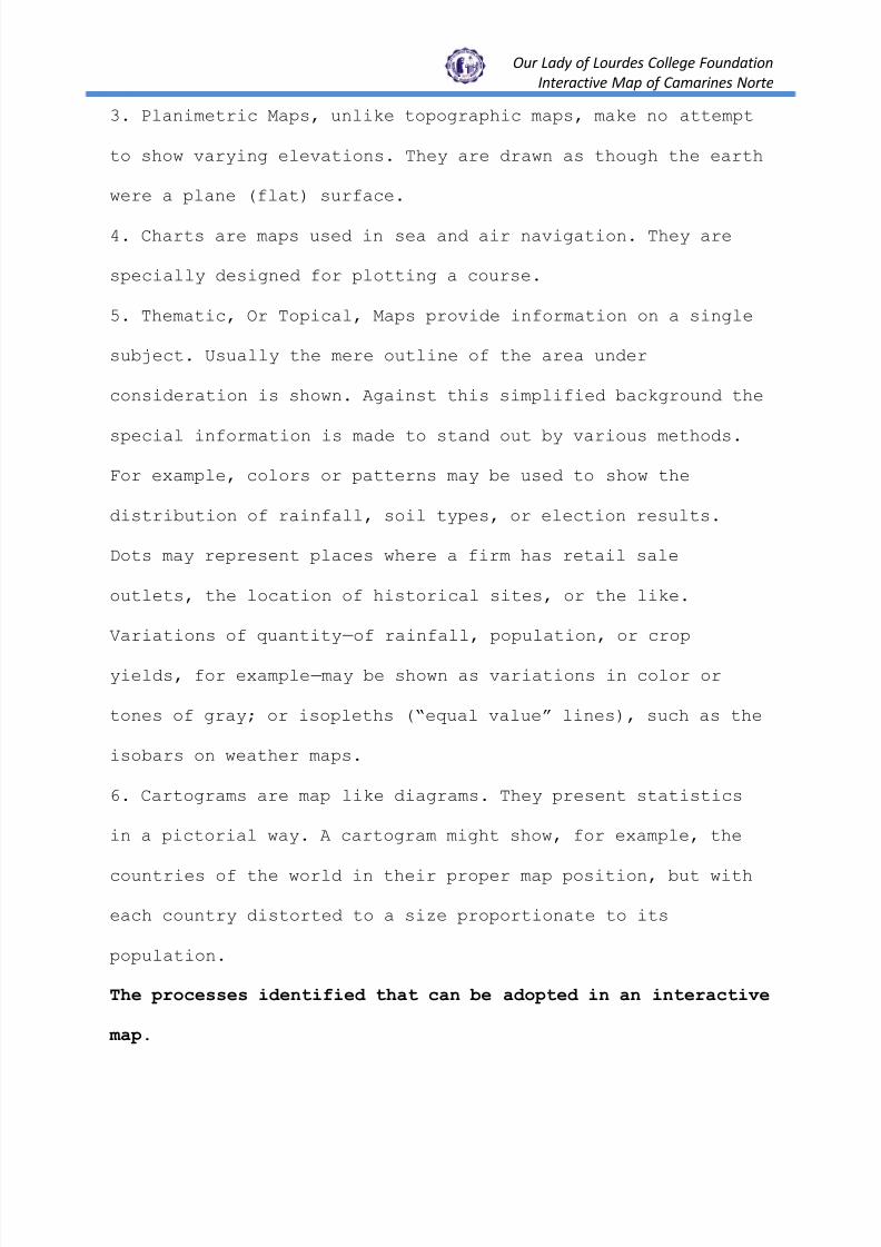
3. Planimetric Maps, unlike topographic maps, make no attempt
to show varying elevations. They are drawn as though the earth
were a plane (flat) surface.
4. Charts are maps used in sea and air navigation. They are
specially designed for plotting a course.
5. Thematic, Or Topical, Maps provide information on a single
subject. Usually the mere outline of the area under
consideration is shown. Against this simplified background the
special information is made to stand out by various methods.
For example, colors or patterns may be used to show the
distribution of rainfall, soil types, or election results.
Dots may represent places where a firm has retail sale
outlets, the location of historical sites, or the like.
Variations of quantity — of rainfall, population, or crop
yields, for example — may be shown as variations in color or
tones of gray; or isopleths (―equal value‖ lines), such as the
isobars on weather maps.
6. Cartograms are map like diagrams. They present statistics
in a pictorial way. A cartogram might show, for example, the
countries of the world in their proper map position, but with
each country distorted to a size proportionate to its
population.
The processes identified that can be adopted in an interactive
map.

8/3/2019 Final Interactive Proj.study
http://slidepdf.com/reader/full/final-interactive-projstudy 33/49
Our Lady of Lourdes College Foundation
Interactive Map of Camarines Norte
The security measures identified that can be adopted in an
interactive map.
Growing concerns about the security and privacy of
personally identifiable information are threatening to
constrain the growth of electronic commerce. There are
hundreds of software developers who created programs when it
comes to online privacy. One of which is the eTrust, the term
"eTrust" means Electronic Trust and relates directly to the
Electronic Trust Foundation. eTrust ensures that your personal
information is protected online. This foundation promotes
privacy and security in the online community.
The eTrust Foundation offers an eTrust Privacy
Certification. This certification seal shows that an online
business or website was reviewed by eTrust and deemed
responsible when it comes to privacy and data protection.
Consumers who perform online transactions often are
concerned for their privacy and the security of their
personal, important information. eTrust strives to aid these
customers and ease their minds. The foundation ensures that
personal details, such as phone numbers and home addresses, do
not ever reach third party companies unless the consumer has
allowed access.
8/3/2019 Final Interactive Proj.study
http://slidepdf.com/reader/full/final-interactive-projstudy 34/49
Our Lady of Lourdes College Foundation
Interactive Map of Camarines Norte
The goal of the eTRUST program is to increase consumer
trust and confidence in electronic transactions, and to
provide an industry driven solution to the problems of online
privacy. In order to increase the level of confidence in
online privacy, eTRUST will provide assurance and monitoring
(through both active and passive means) of the business
practices of entities that have the ability to collect, use
and distribute personal information.

8/3/2019 Final Interactive Proj.study
http://slidepdf.com/reader/full/final-interactive-projstudy 35/49
Our Lady of Lourdes College Foundation
Interactive Map of Camarines Norte
CHAPTER IV
Summary, Conclusions and Recommendations
Summary
This study entitled ―Interactive Map of Camarines Norte‖
aimed to design and develop web-based interactive map that
will cater to the needs of tourist and visitor for easy
navigation.
The Structured Systems Analysis and Design Method (SSADM)
was utilized and document analysis was the main instrument
used to gather data. Internet browsing and library research
were also applied.
Conclusions
In view of the findings, the researchers arrived at the
following conclusions:
1. Interactive map has become a necessity everywhere.
Interactive Map of Camarines Norte provides the quality of
service to the visitors by easy navigation in finding
locations or places and gets an overview in the entire place.
2.
3.

8/3/2019 Final Interactive Proj.study
http://slidepdf.com/reader/full/final-interactive-projstudy 36/49
Our Lady of Lourdes College Foundation
Interactive Map of Camarines Norte
4. E-trust should be adopted by interactive map of Camarines
Norte for security and privacy of the visitors.
Recommendations
Based from the cited conclusions, the following
recommendations were drawn:

8/3/2019 Final Interactive Proj.study
http://slidepdf.com/reader/full/final-interactive-projstudy 37/49
Our Lady of Lourdes College Foundation
Interactive Map of Camarines Norte
References

8/3/2019 Final Interactive Proj.study
http://slidepdf.com/reader/full/final-interactive-projstudy 38/49
Our Lady of Lourdes College Foundation
Interactive Map of Camarines Norte
Appendices

8/3/2019 Final Interactive Proj.study
http://slidepdf.com/reader/full/final-interactive-projstudy 39/49
Our Lady of Lourdes College Foundation
Interactive Map of Camarines Norte
Appendix A
Use Case Diagram of the Proposed System
Figure 2.2 Use Case Diagram
VISITOR ADMINISTRATOR
Document Management System of
Research Collections
VIEW MUNICIPALITIES(BARANGAYS,
RESTAURANT, HOTELSAND TOURIST SPOT)
MANAGE
ADMINISTRATOR ANDUSER ACCOUNTS
8/3/2019 Final Interactive Proj.study
http://slidepdf.com/reader/full/final-interactive-projstudy 40/49
Our Lady of Lourdes College Foundation
Interactive Map of Camarines Norte
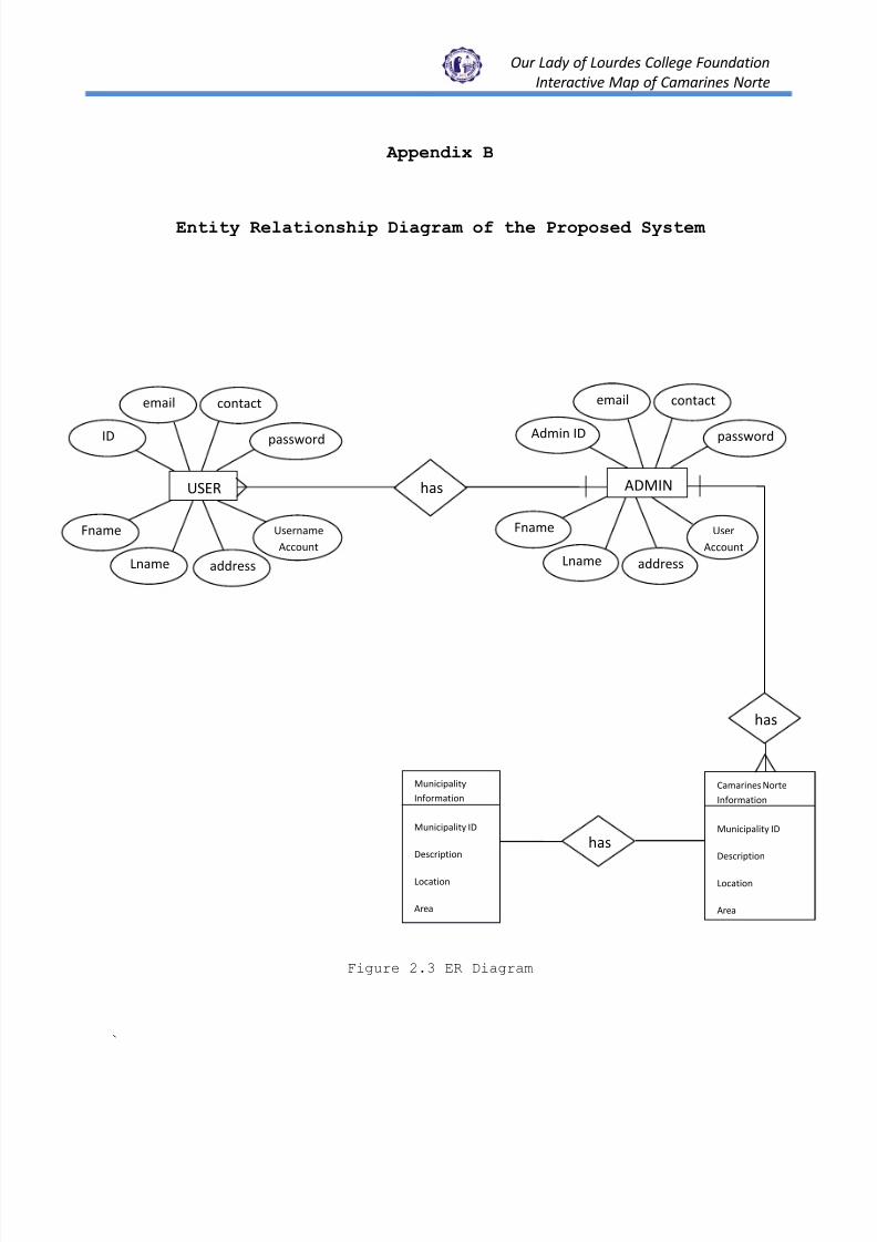
Appendix B
Entity Relationship Diagram of the Proposed System
Figure 2.3 ER Diagram
`
has ADMIN
addressLname
Fname User
Account
has
Camarines Norte
Information
Municipality ID
Description
Location
Area
has
Municipality
Information
Municipality ID
Description
Location
Area
USER
email contact
passwordID
Username
Account
addressLname
Fname
email contact
passwordAdmin ID
8/3/2019 Final Interactive Proj.study
http://slidepdf.com/reader/full/final-interactive-projstudy 41/49
Our Lady of Lourdes College Foundation
Interactive Map of Camarines Norte
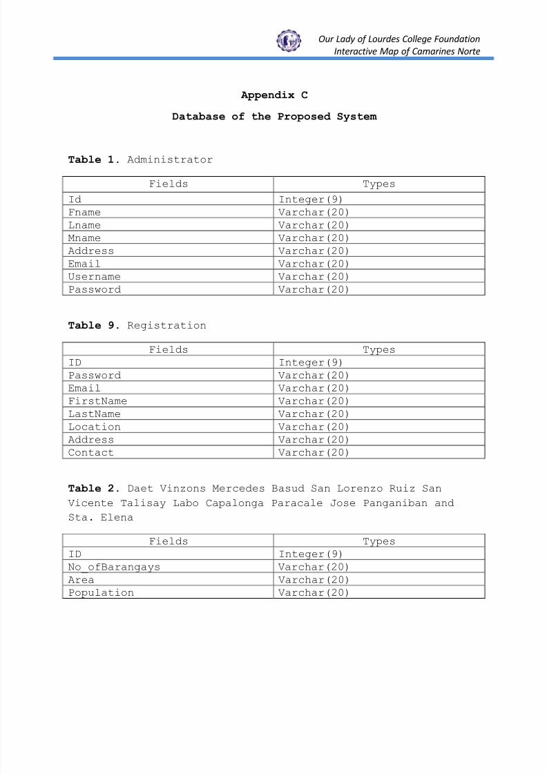
Appendix C
Database of the Proposed System
Table 1. Administrator
Fields Types
Id Integer(9)Fname Varchar(20)Lname Varchar(20)Mname Varchar(20)Address Varchar(20)Email Varchar(20)Username Varchar(20)Password Varchar(20)
Table 9. Registration
Fields TypesID Integer(9)Password Varchar(20)Email Varchar(20)
FirstName Varchar(20)LastName Varchar(20)Location Varchar(20)Address Varchar(20)Contact Varchar(20)
Table 2. Daet Vinzons Mercedes Basud San Lorenzo Ruiz San
Vicente Talisay Labo Capalonga Paracale Jose Panganiban and
Sta. Elena
Fields TypesID Integer(9)No_ofBarangays Varchar(20)Area Varchar(20)Population Varchar(20)
8/3/2019 Final Interactive Proj.study
http://slidepdf.com/reader/full/final-interactive-projstudy 42/49
Our Lady of Lourdes College Foundation
Interactive Map of Camarines Norte
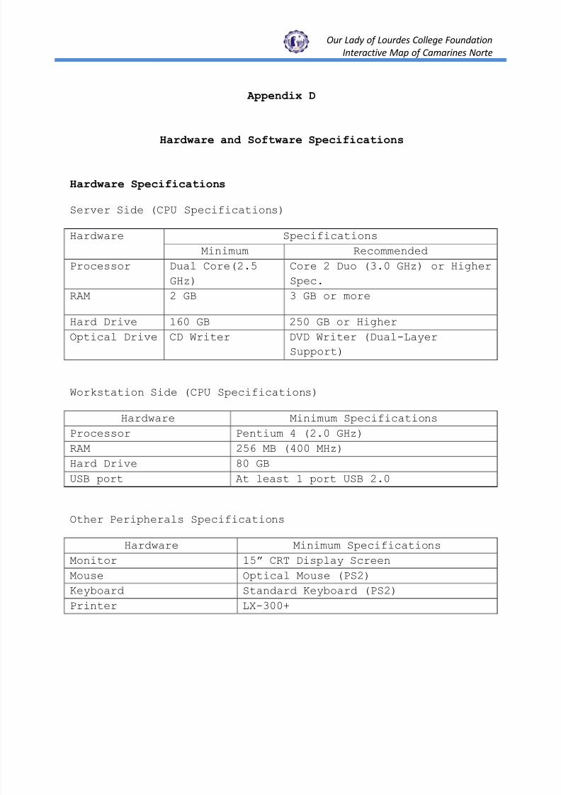
Appendix D
Hardware and Software Specifications
Hardware Specifications
Server Side (CPU Specifications)
Hardware Specifications
Minimum Recommended
Processor Dual Core(2.5
GHz)
Core 2 Duo (3.0 GHz) or Higher
Spec.RAM 2 GB 3 GB or more
Hard Drive 160 GB 250 GB or Higher
Optical Drive CD Writer DVD Writer (Dual-Layer
Support)
Workstation Side (CPU Specifications)
Hardware Minimum SpecificationsProcessor Pentium 4 (2.0 GHz)
RAM 256 MB (400 MHz)
Hard Drive 80 GB
USB port At least 1 port USB 2.0
Other Peripherals Specifications
Hardware Minimum Specifications
Monitor 15‖ CRT Display Screen
Mouse Optical Mouse (PS2)
Keyboard Standard Keyboard (PS2)
Printer LX-300+

8/3/2019 Final Interactive Proj.study
http://slidepdf.com/reader/full/final-interactive-projstudy 43/49
Our Lady of Lourdes College Foundation
Interactive Map of Camarines Norte
Software Specifications
Server Side
Software Minimum Specifications
Server WAMP Server 2.0
Operating System Windows Server 2008
Web Browser Mozilla Firefox 3.0
Workstation Side
Software Minimum Specifications
Operating System Windows XP Service Pack 2
Web Browser Mozilla Firefox 3.0

8/3/2019 Final Interactive Proj.study
http://slidepdf.com/reader/full/final-interactive-projstudy 44/49
Our Lady of Lourdes College Foundation
Interactive Map of Camarines Norte
Appendix E
Screenshots of the Proposed System

8/3/2019 Final Interactive Proj.study
http://slidepdf.com/reader/full/final-interactive-projstudy 45/49
Our Lady of Lourdes College Foundation
Interactive Map of Camarines Norte
Curriculum Vitae
Name : Via Monicca Abundo
Age : 22
Birth Date :
Address : Jose Panganiban, Camarines Norte
Sex : Female
Mother’s Name :
Father’s Name :
Mobile No. :
Civil Status : Single
Citizenship : Filipino
Religion : Roman Catholic
EDUCATIONAL BACKGROUND
Elementary : Elementary School
Secondary : Jose Panganiban National High School
Tertiary : Our Lady of Lourdes College Foundation
Course : Computer Programming

8/3/2019 Final Interactive Proj.study
http://slidepdf.com/reader/full/final-interactive-projstudy 46/49
Our Lady of Lourdes College Foundation
Interactive Map of Camarines Norte
Curriculum Vitae
Name : Alvin Barlintangco
Age : 23
Birth Date :
Address : Moreno Daet, Camarines Norte
Sex : Male
Mother’s Name :
Father’s Name :
Mobile No. :
Civil Status : Single
Citizenship : Filipino
Religion : Roman Catholic
EDUCATIONAL BACKGROUND
Elementary : La Consolacion College-Daet
Secondary : La Consolacion College-Daet
Tertiary : Our Lady of Lourdes College Foundation
Course : Computer Programming
Graduated : Bachelor of Science in Criminology

8/3/2019 Final Interactive Proj.study
http://slidepdf.com/reader/full/final-interactive-projstudy 47/49
Our Lady of Lourdes College Foundation
Interactive Map of Camarines Norte
Curriculum Vitae
Name : Juliet C. Camacho
Age : 19
Birth Date : May 20, 1991
Address : Brgy. Mantagbac Daet, Camarines Norte
Sex : Female
Mother’s Name : Lorna C. Camacho
Father’s Name : Antonio L. Camacho
Mobile No. : 09078866320
Civil Status : Single
Citizenship : Filipino
Religion : Born Again
EDUCATIONAL BACKGROUND
Elementary : Mantagbac Elementary School
Secondary : Basud National High School
Tertiary : Colegio de San Juan de Letran
Undergraduate : Bachelor of Science in Information Technology
Our Lady of Lourdes College Foundation
Course : Computer Programming

8/3/2019 Final Interactive Proj.study
http://slidepdf.com/reader/full/final-interactive-projstudy 48/49
Our Lady of Lourdes College Foundation
Interactive Map of Camarines Norte
Curriculum Vitae
Name : Richelle Espinas
Age : 18
Birth Date :
Address : Tawig Paracale, Camarines Norte
Sex : Female
Mother’s Name :
Father’s Name :
Mobile No. :
Civil Status : Single
Citizenship : Filipino
Religion : Roman Catholic
EDUCATIONAL BACKGROUND
Elementary : Elementary School
Secondary : National High School
Tertiary : Our Lady of Lourdes College Foundation
Course : Computer Programming

8/3/2019 Final Interactive Proj.study
http://slidepdf.com/reader/full/final-interactive-projstudy 49/49
Our Lady of Lourdes College Foundation
Interactive Map of Camarines Norte


