
EUM/LEO-EPSSG/VWG/15/794433 17/02/20151
EPS-SG OBSERVATION MISSIONS
NWC SAF USERS WORKSHOP 24-26/02/2015
2 EUM/LEO-EPSSG/VWG/15/794433 17/02/2015
EPS-SG
• Continuity of the EUMETSAT Polar System Services beyond 2020
− Provision of continuous long-term datasets in support of operational meteorological and environmental forecasting and global climate monitoring
• EPS-SG will be part of the NOAA/EUMETSAT Joint Polar System
− Service in the mid-morning orbit
• EPS-SG will fulfil the European contribution to the GOS as concerns the space-based observations from polar orbits
• EPS-SG will rely on international cooperation for the development and on national contributions for key instruments− ESA: development of the space segment− CNES: development IASI-NG− DLR: development of METimage
•
3 EUM/LEO-EPSSG/VWG/15/794433 17/02/2015
Observation missions
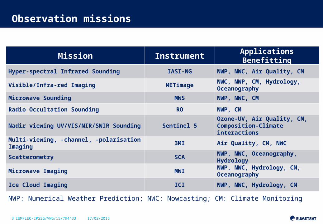
Mission Instrument Applications Benefitting
Hyper-spectral Infrared Sounding IASI-NG NWP, NWC, Air Quality, CM
Visible/Infra-red Imaging METimageNWC, NWP, CM, Hydrology, Oceanography
Microwave Sounding MWS NWP, NWC, CMRadio Occultation Sounding RO NWP, CM
Nadir viewing UV/VIS/NIR/SWIR Sounding
Sentinel 5Ozone-UV, Air Quality, CM, Composition-Climate interactions
Multi-viewing, -channel, -polarisation Imaging
3MI Air Quality, CM, NWC
Scatterometry SCANWP, NWC, Oceanography, Hydrology
Microwave Imaging MWINWP, NWC, Hydrology, CM, Oceanography
Ice Cloud Imaging ICI NWP, NWC, Hydrology, CM
NWP: Numerical Weather Prediction; NWC: Nowcasting; CM: Climate Monitoring
4 EUM/LEO-EPSSG/VWG/15/794433 17/02/2015
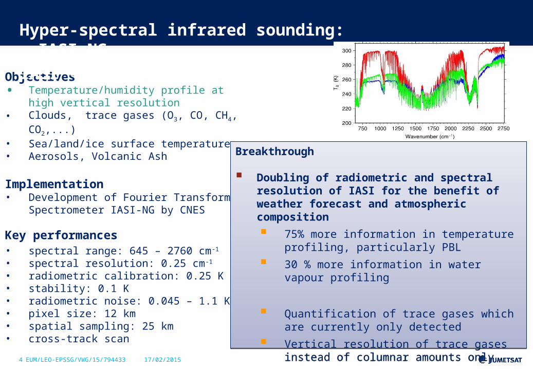
Objectives• Temperature/humidity profile at high vertical
resolution• Clouds, trace gases (O3, CO, CH4, CO2,...)• Sea/land/ice surface temperature• Aerosols, Volcanic Ash
Implementation• Development of Fourier Transform
Spectrometer IASI-NG by CNES
Key performances • spectral range: 645 – 2760 cm-1
• spectral resolution: 0.25 cm-1 • radiometric calibration: 0.25 K• stability: 0.1 K• radiometric noise: 0.045 – 1.1 K• pixel size: 12 km• spatial sampling: 25 km• cross-track scan
Hyper-spectral infrared sounding: IASI-NG
IASI – NG (New Generation)
Breakthrough
Doubling of radiometric and spectral resolution of IASI for the benefit of weather forecast and atmospheric composition
75% more information in temperature profiling, particularly PBL
30 % more information in water vapour profiling
Quantification of trace gases which are currently only detected
Vertical resolution of trace gases instead of columnar amounts only

5 EUM/LEO-EPSSG/VWG/15/794433 17/02/2015
Objectives• Hi-res cloud products, incl. microphysics• Aerosols• Polar AMVs• Vegetation, snow, fire• Sea/ice/land surface temperature• Support to sounding missions
Implementation• Development of METimage by DLR
Key performances • 20 channels: 0.443 – 13.345 µm• absolute calibration:
5% (short-wave)0.5 K (long-wave)
• radiometric sensitivity: SNR 60 – 500 (short-wave)0.05 – 0.2 K (long-wave)
• spatial sampling: 500 m • cross-track scan
Optical imaging: METimage
Breakthrough
Far more spectral channels than AVHRR for the benefit of measuring more variables
Higher spatial sampling (500 m):
more complete coverage through greater likelihood to measure surface variables in partly cloud conditions
Better radiometric resolution for more accurate quantification of many variables

6 EUM/LEO-EPSSG/VWG/15/794433 17/02/2015
Objectives• Temperature/humidity profiles in clear and
cloudy air• Cloud liquid water total column• Imagery: precipitation
Implementation• ESA development
Key performances • 24 channels: 23.8 – 229 GHz• absolute calibration: 0.5 K• radiometric noise: 0.2 – 1.6 K• footprint size: 17 – 40 km• cross-track scan
Microwave sounding
Breakthrough
Addition of a quasi-window channel at 229 GHz (recommended by ITSC-11)
Cirrus cloud information giving a better humidity retrieval performance
Addition of sounding channels + 2 channels at 53-54 GHz + 2 channels at 183.31 GHz
More information on temperature and water vapour profiles
Breakthrough
Addition of a quasi-window channel at 229 GHz (recommended by ITSC-11)
Cirrus cloud information giving a better humidity retrieval performance
Addition of sounding channels + 2 channels at 53-54 GHz + 2 channels at 183.31 GHz
More information on temperature and water vapour profiles
7 EUM/LEO-EPSSG/VWG/15/794433 17/02/2015
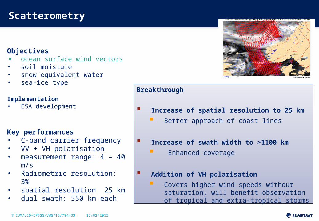
Objectives• ocean surface wind vectors• soil moisture• snow equivalent water• sea-ice type
Implementation• ESA development
Key performances • C-band carrier frequency• VV + VH polarisation • measurement range: 4 – 40 m/s• Radiometric resolution: 3%• spatial resolution: 25 km• dual swath: 550 km each
Scatterometry
Breakthrough
Increase of spatial resolution to 25 km
Better approach of coast lines
Increase of swath width to >1100 km
Enhanced coverage
Addition of VH polarisation
Covers higher wind speeds without saturation, will benefit observation of tropical and extra-tropical storms
Breakthrough
Increase of spatial resolution to 25 km
Better approach of coast lines
Increase of swath width to >1100 km
Enhanced coverage
Addition of VH polarisation
Covers higher wind speeds without saturation, will benefit observation of tropical and extra-tropical storms

8 EUM/LEO-EPSSG/VWG/15/794433 17/02/2015
Objectives
• Refractivity profiles at high vert. resolution • Temperature / humidity profiles• PBL top and tropopause height• Ionospheric electron content
Implementation• ESA development
Key performances • tracking of GPS and Galileo satellites• optional: GLONASS and COMPASS• RO on two satellites: > 2600 occultations per day• bending angle accuracy: 0.5 µrad or 0.2%
Radio occultation sounding
Breakthrough
Tracking of GPS and Galileo satellites to double the number of occultation measurements, optionally also GLONASS and Beidou
Equipment of both Metop-SG satellites with RO
Breakthrough
Tracking of GPS and Galileo satellites to double the number of occultation measurements, optionally also GLONASS and Beidou
Equipment of both Metop-SG satellites with RO
9 EUM/LEO-EPSSG/VWG/15/794433 17/02/2015
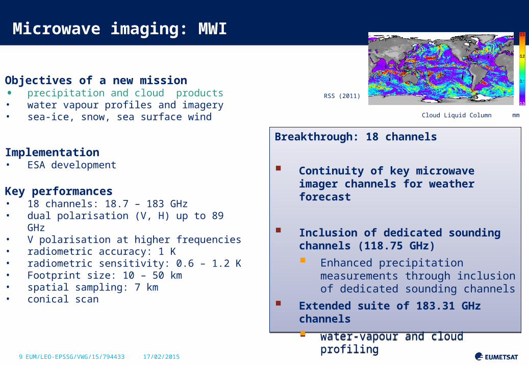
Objectives of a new mission• precipitation and cloud products• water vapour profiles and imagery• sea-ice, snow, sea surface wind
Implementation• ESA development
Key performances • 18 channels: 18.7 – 183 GHz• dual polarisation (V, H) up to 89 GHz• V polarisation at higher frequencies• radiometric accuracy: 1 K• radiometric sensitivity: 0.6 – 1.2 K• Footprint size: 10 – 50 km• spatial sampling: 7 km• conical scan
Microwave imaging: MWI
mm
RSS (2011)
Cloud Liquid Column
Breakthrough: 18 channels
Continuity of key microwave imager channels for weather forecast
Inclusion of dedicated sounding channels (118.75 GHz)
Enhanced precipitation measurements through inclusion of dedicated sounding channels
Extended suite of 183.31 GHz channels
water-vapour and cloud profiling

10 EUM/LEO-EPSSG/VWG/15/794433 17/02/2015
Objectives of a new mission Cloud products, in particular ice clouds• Snowfall detection and quantification• Water-vapour profiles and imagery
Implementation• ESA development
Key performances • 11 channels: 183 – 664 GHz• single polarisation (V) for all channels• dual polarisation (V, H) at 243 and 664 GHz• radiometric accuracy: 1 – 1.5 K• radiometric sensitivity: 0.6 – 1.9 K• Footprint size: 15-16 km• spatial sampling: 7.5 km• conical scan
Ice cloud imaging: ICI
NASA: Aura/MLS
Breakthrough: 11 channels
Establishes operational ice-cloud imaging mission
Support of weather forecast, hydrology, and climate monitoring
Breakthrough: 11 channels
Establishes operational ice-cloud imaging mission
Support of weather forecast, hydrology, and climate monitoring
11 EUM/LEO-EPSSG/VWG/15/794433 17/02/2015
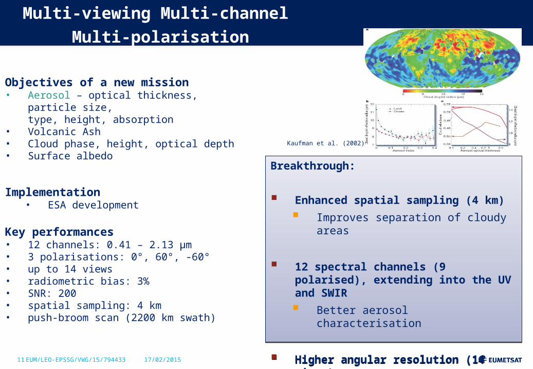
Objectives of a new mission• Aerosol – optical thickness, particle size,
type, height, absorption• Volcanic Ash• Cloud phase, height, optical depth• Surface albedo
Implementation• ESA development
Key performances • 12 channels: 0.41 – 2.13 µm• 3 polarisations: 0°, 60°, -60°• up to 14 views• radiometric bias: 3%• SNR: 200• spatial sampling: 4 km• push-broom scan (2200 km swath)
Multi-viewing Multi-channel Multi-polarisation Imaging:
3MI
Kaufman et al. (2002)
Breakthrough:
Enhanced spatial sampling (4 km)
Improves separation of cloudy areas
12 spectral channels (9 polarised), extending into the UV and SWIR
Better aerosol characterisation
Higher angular resolution (14 views)
Better phase function characterisation
Breakthrough:
Enhanced spatial sampling (4 km)
Improves separation of cloudy areas
12 spectral channels (9 polarised), extending into the UV and SWIR
Better aerosol characterisation
Higher angular resolution (14 views)
Better phase function characterisation

12 EUM/LEO-EPSSG/VWG/15/794433 17/02/2015
Objectives• Ozone profile and column• Columns of CO2,SO2, NO2, H2O,
CO, CH4 • Aerosol optical depth• Columns of BrO, HCHO, OCHCHO• Volcanic Plumes
Implementation• Copernicus Sentinel-5 to be
embarked on Metop-SG• ESA development
Key performances • spectral range: 0.27 – 2.385 µm• spectral resolution: 0.25 – 1 nm• radiometric calibration: 1 – 2%• SNR: 120 - 1500• spatial sampling: 7 km• Cross-track scan
Nadir-viewing UVNS sounding: Sentinel-5
Nadir viewing UV/VIS/NIR/SWIR sounding
XXXXX
Breakthrough
Drastically increased spatial sampling (7 km)
for the benefit of air quality monitoring
Extended spectral range into the near and shortwave infrared regions
to measure aerosols as well as methane and carbon monoxide in the PBL
Breakthrough
Drastically increased spatial sampling (7 km)
for the benefit of air quality monitoring
Extended spectral range into the near and shortwave infrared regions
to measure aerosols as well as methane and carbon monoxide in the PBL

13 EUM/LEO-EPSSG/VWG/15/794433 17/02/2015
Synergy of observation missions
Observation missions arehighly complementary• Co-registration of measurements will allow
to optimise the information extraction• Synergy to be considered in payload
distribution of a dual satellite configuration
Essential co-registrations
• IAS – VII – UVNS • MWI - ICI
Desired co-registrations• IAS – MWS• VII – 3MI• IAS – UVNS – 3MI• MWI – SCA
14 EUM/LEO-EPSSG/VWG/15/794433 17/02/2015
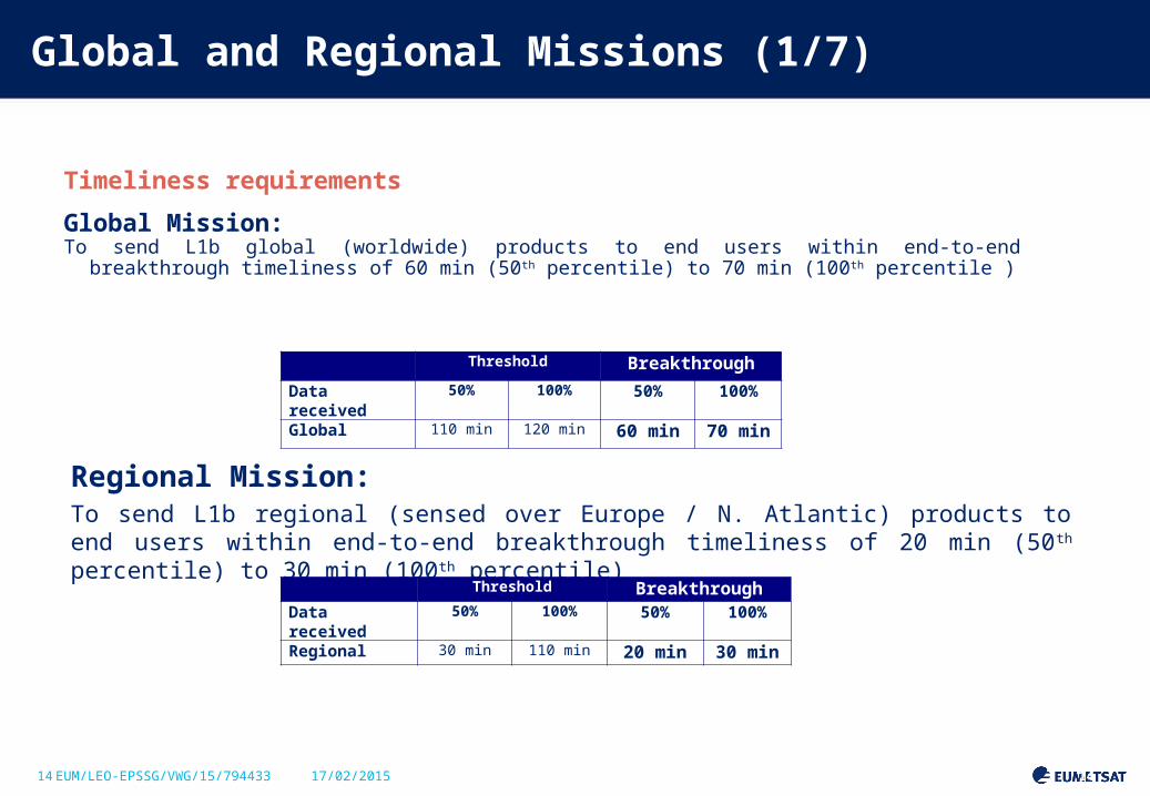
Global and Regional Missions (1/7)
Timeliness requirements
Global Mission:To send L1b global (worldwide) products to end users within end-to-end breakthrough timeliness
of 60 min (50th percentile) to 70 min (100th percentile )
Slide: 14
Regional Mission:To send L1b regional (sensed over Europe / N. Atlantic) products to end users within end-to-end breakthrough timeliness of 20 min (50th percentile) to 30 min (100th percentile)
Threshold BreakthroughData received 50% 100% 50% 100%
Regional 30 min 110 min 20 min 30 min
Threshold Breakthrough
Data received 50% 100% 50% 100%
Global 110 min 120 min 60 min 70 min
*
15 EUM/LEO-EPSSG/VWG/15/794433 17/02/2015
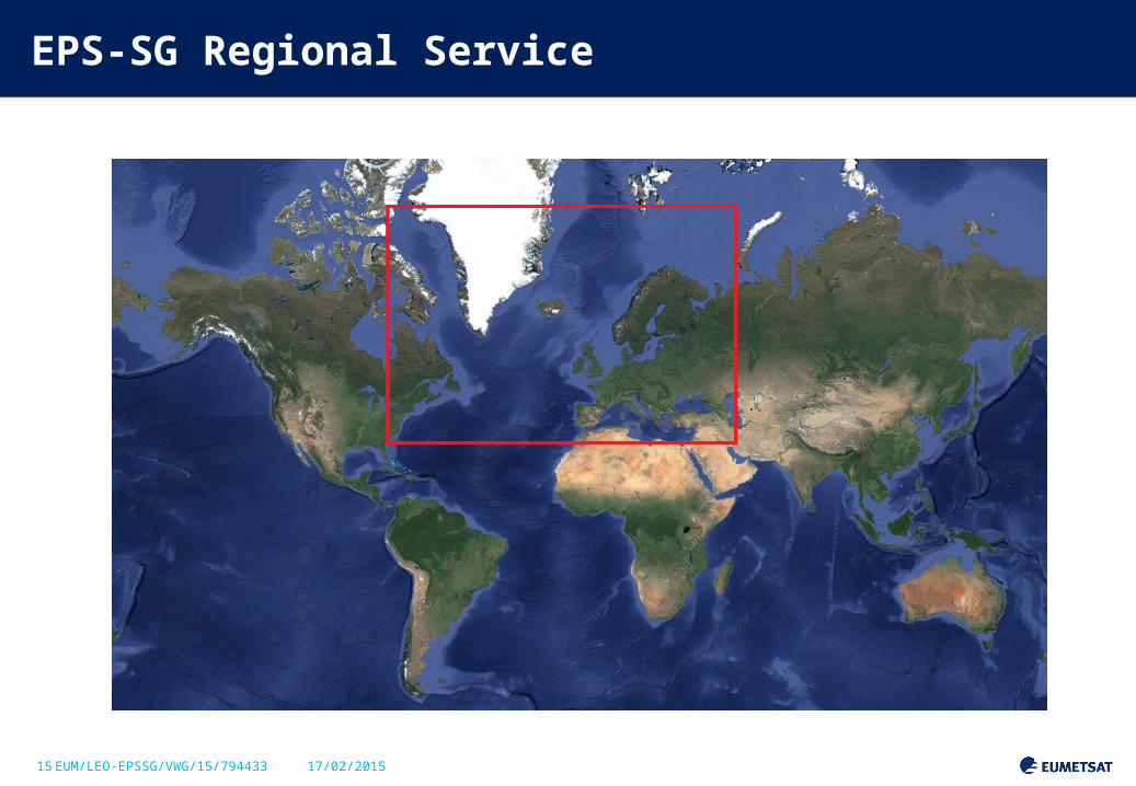
EPS-SG Regional Service
16 EUM/LEO-EPSSG/VWG/15/794433 17/02/2015
EPS-SG in-orbit configuration
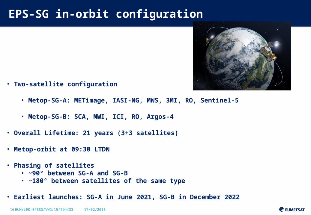
• Two-satellite configuration
• Metop-SG-A: METimage, IASI-NG, MWS, 3MI, RO, Sentinel-5
• Metop-SG-B: SCA, MWI, ICI, RO, Argos-4
• Overall Lifetime: 21 years (3+3 satellites)
• Metop-orbit at 09:30 LTDN
• Phasing of satellites• ~90° between SG-A and SG-B• ~180° between satellites of the same type
• Earliest launches: SG-A in June 2021, SG-B in December 2022


