
Water Supply ProjectEastern and Midlands Region Appendix ERaw Water Abstraction Site Selection

Water Supply Project, Eastern and Midlands Region
Irish Water
Final Options Appraisal Report – Non Linear Infrastructure Siting
Appendix E Raw Water Abstraction Site Selection
November 2016
Final Options Appraisal Report
Irish Water

Final Options Appraisal Report Appendix E Raw Water Abstraction Site Selection
161028WSP1_FOAR Appendix E
Contents
1. Raw Water Abstraction Siting – Process Summary .............................................................................. 1
2. Abstraction Location from POAR .......................................................................................................... 27
3. Screening to Identify Preliminary Sites................................................................................................. 28
4. RWA Site 1 (Western Shore) .................................................................................................................. 38
5. RWA Site 2 (Western Shore) .................................................................................................................. 43
6. RWA Site 3 (Eastern Shore) ................................................................................................................... 48
7. RWA Site 4 (East Shore) ......................................................................................................................... 53
8. RWA Sites – MCA Comparison .............................................................................................................. 58

Final Options Appraisal Report Appendix E Raw Water Abstraction Site Selection
161028WSP1_FOAR Appendix E 1
1. Raw Water Abstraction Siting – Process Summary
Option C (Parteen Basin Reservoir Direct) has been confirmed as the Preferred Scheme on environmental
grounds, on cost-benefit grounds, and in terms of meeting the fundamental objectives of the Water Services
Strategic Plan and of the WSP itself; refer to Section 9 of the Final Options Appraisal Report (FOAR).
The Preferred Scheme will comprise a number of constituent components of infrastructure that collectively make
up the water supply system (Figure 1.1). These can broadly be defined as:
Non – Linear Infrastructure, including the Raw Water Abstraction Works, Water Treatment Plant,
Break Pressure Tank and Termination Point Reservoir (FOAR Section 11) and
The Transmission Pipeline (Linear Infrastructure) – refer to FOAR Section 12.
Figure 1.1 The Transmission Pipeline (Linear Infrastructure) and Other (Non – Linear Infrastructure)
FOAR Sections 11 and 12 outline how the different siting options for these components were developed to
minimise impact on their environment; Appendices E to H detail the appraisal of these site and route options.
They set out multi-criteria analyses (MCA) of the options available, to identify a preferred site for each
component from the multiple sites considered (FOAR Section 11), and to identify the preferred pipeline route
corridor in a similar way (FOAR Section 12), with recommendations on preferred sites and pipeline routes.
The process of multi-criteria analysis is outlined in the FOAR Section 11.1.

Final Options Appraisal Report Appendix E Raw Water Abstraction Site Selection
161028WSP1_FOAR Appendix E 2
The non – linear infrastructure components comprise the followings assets:
Intake and Raw Water Pumping Station (FOAR Section 11.3 and this Appendix E)
Abstraction of raw water will be from the Lower Lake (Parteen Basin) via a submerged pipeline or
open channels, which will extend a relatively short distance out into the basin. The abstraction works
will incorporate a raw water pumping station which will deliver raw water to the proposed water
treatment plant.
Water Treatment Plant (FOAR Section 11.4 and Appendix F)
The water treatment plant will treat the raw water from Parteen Basin to Drinking Water Standards for
human consumption in accordance with relevant legislation. The water treatment plant will also
incorporate a high lift pumping station to deliver treated water to a Break Pressure Tank.
Note: The transmission pipeline is discussed in FOAR Section 12 and Appendix I.
Break Pressure Tank (FOAR Section 11.5 and Appendix G)
A Break Pressure Tank (BPT) will be located at the highest elevation of the transmission pipeline and
is required to manage the water pressures that will be generated in the operation of the transmission
pipeline. The tank is the point at which the transmission line will change from a pumped to a gravity
flow. In practice, treated water will be pumped from the water treatment plant to this tank, and the
water will flow by gravity from the tank to the termination point reservoir. It will act as a balancing tank
for pumped flows, e.g. from the WTP, it will help to limit variability in operating pressures, and it will
provide sufficient storage such that there is adequate reserve flow to maintain the on-going pipe full
after the pumps have stopped or tripped.
Termination Point Reservoir (FOAR Section 11.6 and Appendix H)
Located at the end of the transmission pipeline, the Termination Point Reservoir (TPR) acts as storage
facility for the treated water; providing capacity to serve the varying demand profile of the Dublin Water
Supply Area. The TPR will be integrated with the existing water distribution system (FOAR Section
11.7) at Peamount in south Dublin, ensuring onward transmission to end users.
This Section E describes the multi criteria analysis (MCA) process used to appraise a Least Constrained Raw
Water Abstraction Site (RWA) for the Intake and Raw Water Pumping Station.
Multi criteria analysis (MCA) is a mechanism that explicitly considers multiple criteria within a decision-
making environment. The fundamental approach is to utilise Specialist expertise to conduct the analysis.
Comparing alternatives against multiple objectives and criteria through MCA allows for a collective
balancing of different impact types, understanding of the merits of each option, and the establishment of a
preference ranking, in a collective way; informing and justifying the decision making process.
For the MCA the following specialisms and disciplines were involved:
i. Ecology – the consideration of impact on animals, plants and their environment.
ii. Water – the consideration of impacts on the surface water environment.
iii. Air and Noise - the consideration of air and noise pollution
iv. Cultural Heritage - the consideration of existing archaeological and built heritage
v. Soils, Geology and Hydrogeology – the consideration of impact on soils, geology and
hydrogeology.

Final Options Appraisal Report Appendix E Raw Water Abstraction Site Selection
161028WSP1_FOAR Appendix E 3
vi. Landscape and visual – the consideration of landscape and visual impact.
vii. Agronomy – the consideration of impact on land based enterprise.
viii. People – the consideration of impacts on people
ix. Planning – the consideration of planning and land use policy in relation to proposed works
x. Engineering - the consideration of technical challenges associated with proposed works.
xi. Traffic - the consideration of impact on traffic and road network
The following methodology was employed:
1. Each of the specialist disciplines (identified above) assessed the site options against the
criteria of Table 1-1 to determine the site option for each ancillary component with the overall
least impact from their specialist perspective.
e.g. The ecology specialist assessed the four raw water abstraction sites against Biodiversity,
Flora and Fauna, Fisheries criteria to determine the site option with least impact from an
ecology perspective.
2. The preliminary position of each Specialist, on each ancillary component, presented in matrix
format, was collated for each of the ancillary components and presented at a workshop where
all the Specialists were represented.
e.g. The ecology specialist assessment for raw water abstraction sites was compiled with the
assessments of Air and Noise etc. to present a complete MCA assessment of the sites.
3. In this workshop setting, the matrix of preliminary individual assessments for each individual
component was presented to the collective specialist group. The position of each of the
specialists was then discussed to reach a consensus of agreement on a preferred site for
each main infrastructure component, from the various alternatives.
e.g. The ecology specialist assessment was balanced against that of the other specialists to
inform an overall ranking of raw water abstraction sites, and support preference towards one.
A breakdown of the criteria employed by each of the specialisms is presented in Table 1-1.
Table 1-1 Applicable Criteria for each Specialism
Specialism Applicable Criteria
Ecology Biodiversity, Flora and Fauna, Fisheries
Air and Noise Air/Climatic Factors
Cultural Heritage Cultural Heritage (including Architecture & Archaeology)
Soils, Geology and Hydrogeology
Soils, Geology and Hydrogeology
Landscape and visual
Landscape & Visual
Agronomy Material Assets (Land use)
Water Water
Engineering Material Assets (Energy), Safety, Engineering and Design, Capital and Operational Cost, Sustainability
Planning Planning Policy
People Tourism, Population, Human Health
The Specialists, in completing the MCA, also incorporated feedback from the POAR consultation process,
primarily to establish if the process had identified any new information which needed to be included in the

Final Options Appraisal Report Appendix E Raw Water Abstraction Site Selection
161028WSP1_FOAR Appendix E 4
assessment process for relevant individual specialists. This was to establish if the consultation submissions
contained additional information relevant to the MCA and to determine any impact on the individual
assessments, or collective arrangements facilitated by the workshop setting.
1.1.1 Categories of impact
A simple classification was used for the MCA - one of five categories of impact were applied to each of the
locations under consideration; colour coded for ready identification. These were:
Very high Dark blue
High Blue
Mid-range Green
Low Light Green
Very low Cream
1.2 Identification of Raw Water Abstraction Sites
A preliminary screening of potential Raw Water Abstraction (RWA) sites on Lough Derg and Parteen Basin was
conducted as part of the preparation of the POAR. The POAR identified Parteen Basin as the preferred location
for raw water abstraction.
Abstraction will constitute an open channel or intake pipe along the shoreline of the Parteen Basin. Based on
the preferred location at the Parteen Basin, or the Lower Lake, a number of potential RWA areas were
identified. Collectively, these areas cover the available perimeter on both sides of the Basin, and also a small
area downstream of Lough Derg on the eastern bank which is not designated as a Natura 2000 site. These
areas are presented in Figure 1.2 and included the following:
Western shore of Parteen Basin (RWA1)
Eastern shore of Parteen Basin (RWA2)
Eastern bank of River Shannon, immediately downstream of Lough Derg (RWA3)

Final Options Appraisal Report Appendix E Raw Water Abstraction Site Selection
161028WSP1_FOAR Appendix E 5
Figure 1.2 Potential Raw Water Abstraction Areas in Parteen Basin
Note: the identification of a likely suitable site within the confines of the urban areas of Killaloe and Ballina precluded these
from consideration.
In broad terms, the eastern bank offers potential for siting raw water abstraction infrastructure best aligned with
the treated water pipeline route; the western bank is feasible but is impacted by the additional works which
would be required to convey, via tunnelling, raw water through a pipeline beneath Parteen Basin. The disruptive
impacts, of alternatively routing a large diameter pipeline from the western bank northwards to cross the river in
the Ballina/ Killaloe urban area, have been taken into consideration. RWA3 covers an area of the eastern bank
which is outside the Natura site designation, and which offered some advantage in that regard, but it also has
challenges in routing a pipe through Ballina and its environs. Consequently, due to the extent of the existing
urban development, and steep terrain, RWA3 was discounted from any further consideration.
With regard to RWA1 and RWA2, any identified site would be constrained by the presence of the ESB
embankments1, (refer to FOAR Section 6) and the requirement to avoid potential impact on these through
construction activities.
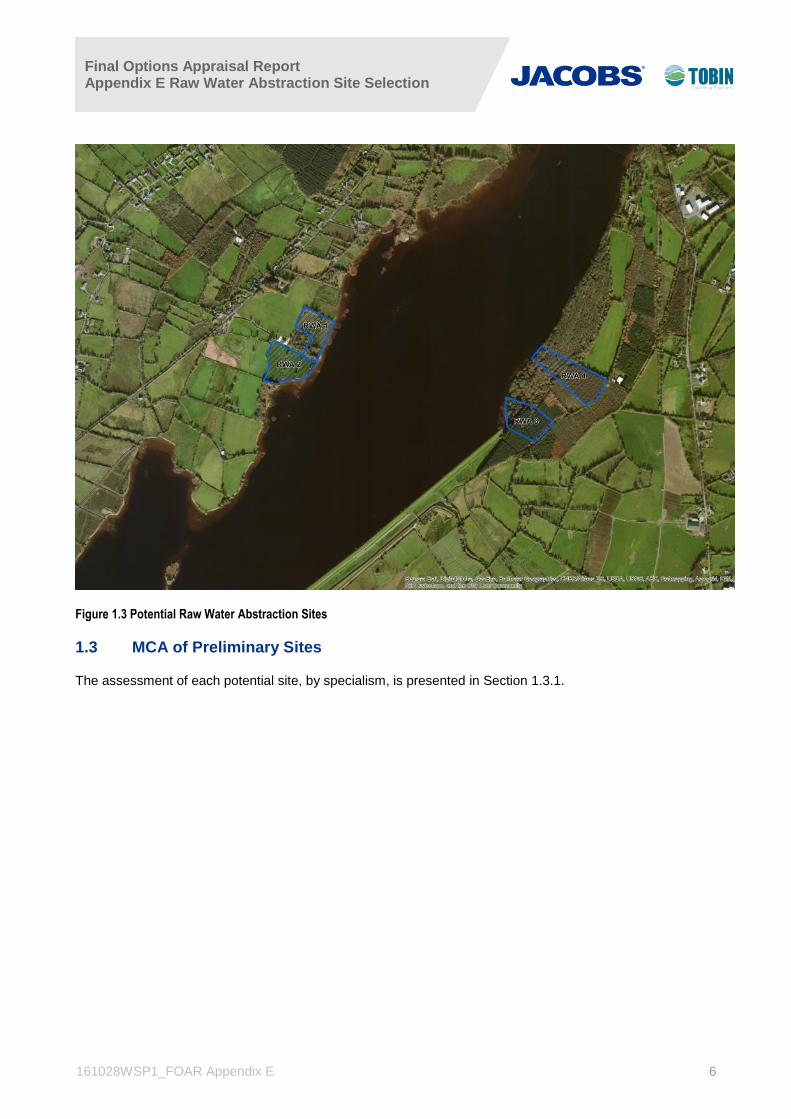
A detailed assessment was undertaken of RWA1 and RWA2 and four potential sites were identified (see Figure
1.3) which were considered potentially suitable having regard to available size, bathymetry, clearance from the
engineering embankments, land topography and position with respect to environmental features and receptors;
two sites on the eastern shore of Parteen Basin and a further two sites on the western shore.
The proximity to the ESB embankment along the eastern shore ruled out a number of potential locations for
sites; other considerations included nearness to existing developments, the requirement to minimise the impact
on designated sites and archaeological sites, local topography, access, etc. Further details are provided in
Appendix F.
1 These are linear embankments which were constructed as part of the Shannon Hydroelectric Scheme (Ardnacrusha), and are managed by the
ESB.
Final Options Appraisal Report Appendix E Raw Water Abstraction Site Selection
161028WSP1_FOAR Appendix E 6
Figure 1.3 Potential Raw Water Abstraction Sites
1.3 MCA of Preliminary Sites
The assessment of each potential site, by specialism, is presented in Section 1.3.1.

Final Options Appraisal Report Appendix E Raw Water Abstraction Site Selection
161028WSP1_FOAR Appendix E 7
1.3.1 Matrix of Multi-Criteria Analysis
Ref Criteria RWA Site 1 RWA Site 2 RWA Site 3 RWA Site 4
1.0 Environmental *
1.1 Biodiversity, Flora & Fauna (Terrestrial)
1.1.1 Potential to impact on Natura 2000 Sites
Site partially within the Lower River Shannon SAC (002165)
Site partially within the Lower River Shannon SAC (002165)
Site partially within the Lower River Shannon SAC (002165)
Site partially within the Lower River Shannon SAC (002165) Requires pipeline crossing of
Parteen Basin, in addition to abstraction facility
Requires pipeline crossing of Parteen Basin, in addition to
abstraction facility
1.1.2 Potential to impact on Natural Heritage Areas and proposed Natural Heritage Areas
N/A N/A N/A N/A
1.1.3 Potential impact Annex I listed habitats (designated)
Site not within or adjacent to habitats listed as qualifying
interests of SAC
Site not within or adjacent to habitats listed as qualifying
interest. of SAC
Site adjacent to but not within qualifying interest of SAC.
Priority Annex I Alluvial woodland to the north
Site within SAC: high quality habitat; broadly corresponding
to priority Annex I Alluvial Woodland
1.1.4 Potential impact Annex I listed habitats (non-designated)
Site surveyed. Very low likelihood of additional Annex I
habitats occurring
Site surveyed. Very low likelihood of additional Annex I
habitats occurring
Site surveyed. Very low likelihood of additional Annex I
habitats occurring
Site surveyed. Low likelihood of additional Annex I habitats
occurring that are not listed as qualifying interests of the SAC
1.1.5 Potential to impact high ecological value habitats (semi natural habitats)
Site will require direct footprint within Parteen Basin and lake shore / fringing wetland habitat
Site will require direct footprint within Parteen Basin and lake shore / fringing wetland habitat
Site will require direct footprint within Parteen Basin and
alluvial / wet woodland habitat not corresponding to priority Annex I Alluvial woodland
Site will require direct footprint within Parteen Basin and priority Annex I Alluvial
woodland habitat
1.1.6 Potential to impact on protected Flora - Flora Protection Order
Site surveyed, no FPO species recorded. Potential
occurrence evaluated as low
Site surveyed, no FPO species recorded. Potential
occurrence evaluated as low
Site surveyed, no FPO species recorded. Potential
occurrence evaluated as low
Site surveyed, no FPO species recorded. Potential occurrence
evaluated as low

Final Options Appraisal Report Appendix E Raw Water Abstraction Site Selection
161028WSP1_FOAR Appendix E 8
Ref Criteria RWA Site 1 RWA Site 2 RWA Site 3 RWA Site 4
1.1.7 Potential to impact on Annex II species
Annex II Otter, listed as qualifying interest of the SAC
occur along the lakeshore within the footprint of this site,
no dwellings recorded.
Annex II Otter, listed as qualifying interest of the SAC
occur along the lakeshore within the footprint of this site,
no dwellings recorded.
Annex II Otter, listed as qualifying interest of the SAC
occur along the lakeshore within the footprint of this site,
no dwellings recorded.
Annex II Otter, listed as qualifying interest of the SAC
occur along the lakeshore within the footprint of this site,
no dwellings recorded.
Additional Annex II species unlikely to occur within the site. Pipeline crossing of
Parteen Basin will increase potential for effects on otter.
Additional Annex II species unlikely to occur within the site. Pipeline crossing of
Parteen Basin will increase potential for effects on otter.
Additional Annex II species unlikely to occur
Additional Annex II species unlikely to occur
1.1.8 Potential to Impact on Annex IV species (wherever they occur)
Otter and all bat species are listed on Annex IV. These
species use and are likely to use this site
Otter and all bat species are listed on Annex IV. These
species use and are likely to use this site
Otter and all bat species are listed on Annex IV. These
species use and are likely to use this site; bat potential is higher within the woodland
habitat.
Otter and all bat species are listed on Annex IV. These
species use and are likely to use this site; bat potential is higher within the woodland
habitat.
1.1.9 Potential to impact on the breeding / wintering habitat for Annex I listed and other qualifying interest bird species
No SPA designation within or adjacent to this site, rank wet
grassland unsuitable for wintering bird species. Low
breeding bird potential
No SPA designation within or adjacent to this site, managed
wet grassland suitable for wintering Annex I birds
(Whooper Swan, Greylag Geese). Breeding bird
potential
No SPA designation within or adjacent to this site, woodland
unsuitable for wintering bird species. Low breeding bird potential, evidence of short-
eared owl.
No SPA designation within or adjacent to this site, woodland
unsuitable for wintering bird species. Low breeding bird
potential
1.1.10 Potential to impact flora and fauna protected under Wildlife Act e.g. Birds, badger
Bird species occur within this site and will be affected. No
sign of badger, other WA species e.g. Common frog
likely to occur
Bird species occur within this site and will be affected. No
sign of badger, other WA species e.g. Common frog
likely to occur
Bird species occur within this site and will be affected.
Evidence of badger activity; other WA species e.g. Pine
marten, Common frog likely to occur
Bird species occur within this site and will be affected. Active badger sett within site. Other WA species e.g. Pine marten, Common frog likely to occur
1.1.11 Potential to impact on salmonid habitat - protected under SI Regulations
N/A - no connectivity to Salmonid watercourse.
Salmonid species do occur
N/A - no connectivity to Salmonid watercourse.
Salmonid species do occur.
N/A - no connectivity to Salmonid watercourse.
Salmonid species do occur.
N/A - no connectivity to Salmonid watercourse.
Salmonid species do occur.
1.1.12 Potential to impact on a freshwater pearl mussel - protected under SI Regulations
N/A - no connectivity to Freshwater Pearl Mussel
watercourse
N/A - no connectivity to Freshwater Pearl Mussel
watercourse
N/A - no connectivity to Freshwater Pearl Mussel
watercourse
N/A - no connectivity to Freshwater Pearl Mussel
watercourse

Final Options Appraisal Report Appendix E Raw Water Abstraction Site Selection
161028WSP1_FOAR Appendix E 9
Ref Criteria RWA Site 1 RWA Site 2 RWA Site 3 RWA Site 4
1.1.13 Potential to impact upon high quality aquatic habitat for protected aquatic species.
Construction and operation within Parteen Basin, SAC
designated for Annex II Atlantic Salmon. Protected
aquatic flora may occur within littoral/benthic zone. Potential significance may decline with further project/survey details. Pipeline crossing of Parteen Basin will increase potential
for effects on high quality aquatic habitat supporting protected aquatic species.
Construction and operation within Parteen Basin, SAC
designated for Annex II Atlantic Salmon. Protected
aquatic flora may occur within littoral/benthic zone. Potential significance may decline with further project/survey details.
Construction and operation within Parteen Basin, SAC
designated for Annex II Atlantic Salmon. Protected
aquatic flora may occur within littoral/benthic zone. Potential significance may decline with further project/survey details.
1.1.14 Potential to impact on coastal zone habitats (intertidal)
N/A - No potential for effects on coastal / marine receptors
N/A - No potential for effects on coastal / marine receptors
N/A - No potential for effects on coastal / marine receptors
N/A - No potential for effects on coastal / marine receptors
1.1.15 Potential to impact on marine habitats (e.g. Subtidal)
N/A - No potential for effects on coastal / marine receptors
N/A - No potential for effects on coastal / marine receptors
N/A - No potential for effects on coastal / marine receptors
N/A - No potential for effects on coastal / marine receptors
1.1.16 Potential to impact marine/coastal birds N/A - No potential for effects on coastal / marine receptors
N/A - No potential for effects on coastal / marine receptors
N/A - No potential for effects on coastal / marine receptors
N/A - No potential for effects on coastal / marine receptors
1.1.17 Potential to impact marine mammals N/A - No potential for effects on coastal / marine receptors
N/A - No potential for effects on coastal / marine receptors
N/A - No potential for effects on coastal / marine receptors
N/A - No potential for effects on coastal / marine receptors
1.2 Biodiversity, Flora & Fauna (Aquatic)
1.2.1 Potential to impact on Natura 2000 Sites Site within the Lower River
Shannon SAC (002165) Site within the Lower River
Shannon SAC (002165) Site within the Lower River
Shannon SAC (002165) Site within the Lower River
Shannon SAC (002165)
1.2.2 Potential to impact on Natural Heritage Areas and proposed Natural Heritage Areas
N/A N/A N/A N/A
1.2.3 Potential impact Annex I listed habitats (designated)
Site not within or adjacent to aquatic habitats listed as
qualifying interests of SAC
Site not within or adjacent to aquatic habitats listed as
qualifying interests of SAC
Site not within or adjacent to aquatic habitats listed as
qualifying interests of SAC
Site not within or adjacent to aquatic habitats listed as
qualifying interests of SAC

Final Options Appraisal Report Appendix E Raw Water Abstraction Site Selection
161028WSP1_FOAR Appendix E 10
Ref Criteria RWA Site 1 RWA Site 2 RWA Site 3 RWA Site 4
1.2.4 Potential impact Annex I listed habitats (non-designated)
Benthic survey results not analysed. Very low likelihood of additional aquatic Annex I
habitats occurring
Benthic survey results not analysed. Very low likelihood of additional aquatic Annex I
habitats occurring
Benthic survey results not analysed. Very low likelihood of additional aquatic Annex I
habitats occurring
Benthic survey results not analysed. Very low likelihood of additional aquatic Annex I
habitats occurring
1.2.5 Potential to impact high ecological value habitats (semi natural habitats)
Site will require direct footprint within Parteen Basin affecting high value lacustrine littoral
and benthic habitat.
Site will require direct footprint within Parteen Basin affecting
high value lacustrine littoral and benthic habitat.
Site will require direct footprint within Parteen Basin affecting high value lacustrine littoral
and benthic habitat.
Site will require direct footprint within Parteen Basin affecting
high value lacustrine littoral and benthic habitat.
1.2.6 Potential to impact on protected Flora - Flora Protection Order
Benthic survey results not analysed. Very low likelihood
of additional aquatic FPO species occurring
Benthic survey results not analysed. Very low likelihood
of additional aquatic FPO species occurring
Benthic survey results not analysed. Very low likelihood
of additional aquatic FPO species occurring
Benthic survey results not analysed. Very low likelihood
of additional aquatic FPO species occurring
1.2.7 Potential to impact on Annex II species
Construction and operation within Parteen Basin, SAC
designated for Annex II Atlantic Salmon and Otter.
The pipeline crossing of Parteen Basin will increase the construction timeframe
and footprint with an associated increase in
ecological disturbance and significance.
Construction and operation within Parteen Basin, SAC
designated for Annex II Atlantic Salmon and Otter. The
pipeline crossing of Parteen Basin will increase the
construction timeframe and footprint with an associated
increase in ecological disturbance and significance.
Construction and operation within Parteen Basin, SAC
designated for Annex II Atlantic Salmon and Otter.
Construction and operation within Parteen Basin, SAC
designated for Annex II Atlantic Salmon and Otter.
1.2.8 Potential to Impact on Annex IV species (wherever they occur)
No aquatic Annex IV species potentially affected
No aquatic Annex IV species potentially affected
No aquatic Annex IV species potentially affected
No aquatic Annex IV species potentially affected
1.2.9 Potential to impact on the breeding / wintering habitat for Annex I listed and other qualifying interest bird species
Breeding and Wintering water birds recorded from the
Parteen Basin waterbody in this wider study area. Pipeline crossing of Parteen Basin will
increase potential for disturbance effects on the
wetland habitats supporting wintering / breeding birds.
Breeding and Wintering water birds recorded from the
Parteen Basin waterbody in this wider study area. Pipeline crossing of Parteen Basin will
increase potential for disturbance effects on the
wetland habitats supporting wintering / breeding birds.
Breeding and Wintering water birds recorded from the
Parteen Basin waterbody in this wider study area
Breeding and Wintering water birds recorded from the
Parteen Basin waterbody in this wider study area

Final Options Appraisal Report Appendix E Raw Water Abstraction Site Selection
161028WSP1_FOAR Appendix E 11
Ref Criteria RWA Site 1 RWA Site 2 RWA Site 3 RWA Site 4
1.2.10 Potential to impact flora and fauna protected under Wildlife Act e.g. Birds, badger
Aquatic species protected under the Wildlife Act include
fish species (Brown Trout, Atlantic Salmon), water birds,
Common frog all of which occur within Parteen Basin in
the vicinity of this location. Pipeline crossing of Parteen Basin will increase potential
for effects on high quality aquatic habitat supporting protected aquatic species.
Aquatic species protected under the Wildlife Act include
fish species (Brown Trout, Atlantic Salmon), water birds,
Common frog all of which occur within Parteen Basin in
the vicinity of this location
Aquatic species protected under the Wildlife Act include
fish species (Brown Trout, Atlantic Salmon), water birds,
Common frog all of which occur within Parteen Basin in
the vicinity of this location
1.2.11 Potential to impact on salmonid habitat - protected under SI Regulations
N/A - no connectivity to Salmonid watercourse.
Salmonid species do occur
N/A - no connectivity to Salmonid watercourse.
Salmonid species do occur.
N/A - no connectivity to Salmonid watercourse.
Salmonid species do occur.
N/A - no connectivity to Salmonid watercourse.
Salmonid species do occur.
1.2.12 Potential to impact on a freshwater pearl mussel - protected under SI Regulations
N/A - no connectivity to Freshwater Pearl Mussel
watercourse
N/A - no connectivity to Freshwater Pearl Mussel
watercourse
N/A - no connectivity to Freshwater Pearl Mussel
watercourse
N/A - no connectivity to Freshwater Pearl Mussel
watercourse
1.2.13 Potential to impact upon high quality aquatic habitat for protected aquatic species.
Site within the Lower River Shannon SAC (002165)
designated for Atlantic Salmon and Otter. Pipeline crossing of
Parteen Basin will increase potential for effects on high
quality aquatic habitat supporting protected aquatic
species.
Site within the Lower River Shannon SAC (002165)
designated for Atlantic Salmon and Otter. Pipeline crossing of
Parteen Basin will increase potential for effects on high
quality aquatic habitat supporting protected aquatic
species.
Site within the Lower River Shannon SAC (002165)
designated for Atlantic Salmon and Otter
Site within the Lower River Shannon SAC (002165)
designated for Atlantic Salmon and Otter
1.2.14 Potential to impact on coastal zone habitats (intertidal)
N/A - No potential for effects on coastal / marine receptors
N/A - No potential for effects on coastal / marine receptors
N/A - No potential for effects on coastal / marine receptors
N/A - No potential for effects on coastal / marine receptors
1.2.15 Potential to impact on marine habitats (e.g. Subtidal)
N/A - No potential for effects on coastal / marine receptors
N/A - No potential for effects on coastal / marine receptors
N/A - No potential for effects on coastal / marine receptors
N/A - No potential for effects on coastal / marine receptors

Final Options Appraisal Report Appendix E Raw Water Abstraction Site Selection
161028WSP1_FOAR Appendix E 12
Ref Criteria RWA Site 1 RWA Site 2 RWA Site 3 RWA Site 4
1.2.16 Potential to impact marine/coastal birds N/A - No potential for effects on coastal / marine receptors
N/A - No potential for effects on coastal / marine receptors
N/A - No potential for effects on coastal / marine receptors
N/A - No potential for effects on coastal / marine receptors
1.2.17 Potential to impact marine mammals N/A - No potential for effects on coastal / marine receptors
N/A - No potential for effects on coastal / marine receptors
N/A - No potential for effects on coastal / marine receptors
N/A - No potential for effects on coastal / marine receptors
1.3 Fisheries
1.3.1 Potential to impact on water quality and inshore fishing grounds based on regional fisheries datasets.
Based on proposed operational regime with
imperceptible impact on water levels, significance of potential
impact on inshore fisheries (European eel) are evaluated
as low. Further evaluation required based on
construction and operational details
Based on proposed operational regime with
imperceptible impact on water levels, significance of potential
impact on inshore fisheries (European eel) are evaluated
as low. Further evaluation required based on
construction and operational details
Based on proposed operational regime with
imperceptible impact on water levels, significance of potential
impact on inshore fisheries (European eel) are evaluated
as low. Further evaluation required based on
construction and operational details
Based on proposed operational regime with
imperceptible impact on water levels, significance of potential
impact on inshore fisheries (European eel) are evaluated
as low. Further evaluation required based on construction
and operational details
1.3.2
Potential to impact on transient protected marine species (cetaceans and salmonids), which may pass through the affected area within the survey area footprint.
Based on proposed operational regime with
imperceptible impact on water levels, significance of potential
impact on migratory Atlantic Salmon evaluated as low.
Further evaluation required based on construction and
operational details
Based on proposed operational regime with
imperceptible impact on water levels, significance of potential
impact on migratory Atlantic Salmon evaluated as low.
Further evaluation required based on construction and
operational details
Based on proposed operational regime with
imperceptible impact on water levels, significance of potential
impact on migratory Atlantic Salmon evaluated as low.
Further evaluation required based on construction and
operational details
Based on proposed operational regime with
imperceptible impact on water levels, significance of potential
impact on migratory Atlantic Salmon evaluated as low.
Further evaluation required based on construction and
operational details

Final Options Appraisal Report Appendix E Raw Water Abstraction Site Selection
161028WSP1_FOAR Appendix E 13
Ref Criteria RWA Site 1 RWA Site 2 RWA Site 3 RWA Site 4
1.4 Water
1.4.1
Potential to support the objectives of the WFD water bodies. - Potential to impact on the water quality, hydro morphology of a WFD water bodies of "good" or higher status. - Potential to impact on a WFD Annex IV - Protected Areas: A) Waters used for the abstraction of drinking water - Potential to impact on a WFD Annex IV - Protected Areas: B) Areas designated to protect economically significant aquatic species - Potential to impact on a WFD Annex IV - Protected Areas: C) Recreational Waters - Potential to impact on a WFD Annex IV - Protected Areas: D) Nutrient Sensitive Areas - Potential to impact on a WFD Annex IV - Protected Areas: E) Areas designated for the protection of habitats or species (Ecology Scope)
The constraint associated with all sites are similar: - the lake body is a drinking water body - the lake body is nutrient sensitive - the lake body is an SAC waterbody However, due to the requirement to transfer abstracted water from the western shore to the eastern shore this along with RWA 1 would be the more constrained option.
The constraint associated with all sites are similar: - the lake body is a drinking water body - the lake body is nutrient sensitive - the lake body is an SAC waterbody However, due to the requirement to transfer abstracted water from the western shore to the eastern shore this along with RWA 2 would be the more constrained option.
The constraint associated with all sites are similar: - the lake body is a drinking water body - the lake body is nutrient sensitive - the lake body is an SAC waterbody There is no requirement to transfer abstracted water from the western shore to the eastern shore therefore this location would be the least constrained option compared to RWA 1 & 2. The site is similar to RWA 4.
The constraint associated with all sites are similar: - the lake body is a drinking water body - the lake body is nutrient sensitive - the lake body is an SAC waterbody There is no requirement to transfer abstracted water from the western shore to the eastern shore therefore this location would be the least constrained option compared to RWA 1 & 2. The site is similar to RWA3.

Final Options Appraisal Report Appendix E Raw Water Abstraction Site Selection
161028WSP1_FOAR Appendix E 14
Ref Criteria RWA Site 1 RWA Site 2 RWA Site 3 RWA Site 4
1.4.2
Area prone to flooding (PRFA/SCFRAMs) and predicted flood extents within and adjacent to the site. - Proximity to water bodies in terms of flooding and as an indicator of sensitive surface water receptors.
Some Fluvial flooding the 1%AEP within 100m of the
site
Some Fluvial flooding the 1%AEP within 100m of the site
Some Fluvial flooding the 1%AEP within 100m of the
site and within the site boundary
Some Fluvial flooding the 1%AEP within 100m of the
site and some within the site boundary but less than RWA
4.
1.5 Air/Climatic Factors
NOISE
1.5.1 Potential for Construction phase noise impact at Sensitive receptors
Approx. 140m from site boundary to nearest residential receptor. Approx 70m to nearest non-residential building (use tbc.)
Approx. 240m from site boundary to nearest residential receptor. Site boundary adjoins nearest
non-residential building (use tbc.)
Approx. 320m from site boundary to nearest residential receptor. Site boundary adjoins nearest
non-residential building (use tbc.)
Approx. 680m from site boundary to nearest residential receptor. Approx 320m to nearest non-residential building (use tbc.)
1.5.2 Potential for Operational phase noise impact at Sensitive receptors
Approx. 140m from site boundary to nearest residential receptor. Approx 70m to nearest non-residential building (use tbc.)
Approx. 240m from site boundary to nearest residential receptor. Site boundary adjoins nearest
non-residential building (use tbc.)
Approx. 320m from site boundary to nearest residential receptor. Site boundary adjoins nearest
non-residential building (use tbc.)
Approx. 680m from site boundary to nearest residential receptor. Approx 320m to nearest non-residential building (use tbc.)
1.5.3 Existing Ambient Noise Climate in the Area (significant noise sources)
Nearest residences located along regional road. Existing ambient
and background noise expected to be fairly quiet. TBC
Nearest residences located along regional road. Existing ambient
and background noise expected to be fairly quiet. TBC
Nearest residences located along regional road. Existing ambient
and background noise expected to be fairly quiet. TBC
Nearest residences located along regional road. Existing ambient and background noise expected
to be fairly quiet. TBC
1.5.4 Construction Phase Impact rating Mid Range Low Very Low Very Low
1.5.5 Operational Phase Impact rating Mid Range Low Very Low Very Low
Final Options Appraisal Report Appendix E Raw Water Abstraction Site Selection
161028WSP1_FOAR Appendix E 15
Ref Criteria RWA Site 1 RWA Site 2 RWA Site 3 RWA Site 4
AIR
1.5.6 Potential for Construction phase Air Quality impact at Sensitive receptors
Approx. 140m from site boundary to nearest residential receptor. Approx 70m to nearest non-residetial building (use tbc.)
Approx. 240m from site boundary to nearest residential receptor. Site boundary adjoins nearest
non-residetial building (use tbc.)
Approx. 320m from site boundary to nearest residential receptor. Site boundary adjoins nearest
non-residetial building (use tbc.)
Approx. 680m from site boundary to nearest residential receptor. Approx 320m to nearest non-residetial building (use tbc.)
1.5.7 Potential for Operational phase Air Quality impact at Sensitive receptors
Approx. 140m from site boundary to nearest residential receptor. Approx 70m to nearest non-residetial building (use tbc.)
Approx. 240m from site boundary to nearest residential receptor. Site boundary adjoins nearest
non-residetial building (use tbc.)
Approx. 320m from site boundary to nearest residential receptor. Site boundary adjoins nearest
non-residetial building (use tbc.)
Approx. 680m from site boundary to nearest residential receptor. Approx 320m to nearest non-residetial building (use tbc.)
1.5.8 Proximity to EPA Waste Licensed facility No EPA Waste Licenced Facilities
in the Area No EPA Waste Licenced Facilities
in the Area No EPA Waste Licenced Facilities
in the Area No EPA Waste Licenced
Facilities in the Area
1.5.9 Proximity to EPA IPPC Licensed Intensive Agriculture facility
No EPA IPPC Licensed Intensive Agriculture Facilities in the Area
No EPA IPPC Licensed Intensive Agriculture Facilities in the Area
No EPA IPPC Licensed Intensive Agriculture Facilities in the Area
No EPA IPPC Licensed Intensive Agriculture Facilities in the Area
1.5.10 EPA Air Quality Zone Classification Zone D Zone D Zone D Zone D
1.5.11 Wind Rose Assessment
South Westerly Prevailing Wind. Average Wind Speed of 4.7 m/s
over period 1981- 2010 (Shannon Airport)
South Westerly Prevailing Wind. Average Wind Speed of 4.7 m/s
over period 1981- 2010 (Shannon Airport)
South Westerly Prevailing Wind. Average Wind Speed of 4.7 m/s
over period 1981- 2010 (Shannon Airport)
South Westerly Prevailing Wind. Average Wind Speed of 4.7 m/s
over period 1981- 2010 (Shannon Airport)
1.5.12 Construction Phase Impact rating Mid Range Low Very Low Very Low
1.5.13 Operational Phase Impact rating Very Low Very Low Very Low Very Low
1.6 Material Assets (Energy)
1.6.1 Potential for energy recovery N/A N/A N/A N/A

Final Options Appraisal Report Appendix E Raw Water Abstraction Site Selection
161028WSP1_FOAR Appendix E 16
Ref Criteria RWA Site 1 RWA Site 2 RWA Site 3 RWA Site 4
1.7 Cultural Heritage (including Architecture & Archaeology) - CH
1.7.1 Potential to impact (direct/indirect) on National Monuments (designated sites)
Very low - none present within the receiving environment
Very low - none present within the receiving environment
Very low - none present within the receiving environment
Very low - none present within the receiving
environment
1.7.2 Potential to impact (direct/indirect) on RMPs (designated sites)
Very low - none present within the receiving environment
Very low - none present within the receiving environment
Very low - none present within the receiving environment
Very low - none present within the receiving
environment
1.7.3 Potential to impact (direct/indirect) on RPS (designated sites)
Very low - none present within the receiving environment
Very low - none present within the receiving environment
Very low - none present within the receiving environment
Low - One RPS located over 700m NNE
1.7.4 Potential to impact (direct/indirect) on NIAH Very low - none present within
the receiving environment Very low - none present within
the receiving environment Very low - none present within
the receiving environment
Very low - none present within the receiving
environment
1.7.5 Potential to impact (direct/indirect) on historic designed landscapes
Very low - none present within the receiving environment
Very low - none present within the receiving environment
Very low - none present within the receiving environment
Low - adjacent to Fort Henry demesne
1.7.6 Potential to impact on ACA Very low - none present within
the receiving environment Very low - none present within
the receiving environment Very low - none present within
the receiving environment
Very low - none present within the receiving
environment
1.7.7 Recorded shipwreck sites Very low - none present within
the receiving environment Very low - none present within
the receiving environment Very low - none present within
the receiving environment
Very low - none present within the receiving
environment

Final Options Appraisal Report Appendix E Raw Water Abstraction Site Selection
161028WSP1_FOAR Appendix E 17
Ref Criteria RWA Site 1 RWA Site 2 RWA Site 3 RWA Site 4
1.8 Landscape & Visual
1.8.1 Potential to impact on designated areas of ‘Highly Sensitive Landscape’
High - Contained within a
Heritage landscape designation between R463
and shoreline
High - Contained within a
Heritage landscape designation between R463
and shoreline
High - 'General sensitivity'
identified in current CDP. Draft CDP indicates 'Class 4
sensitivity' (2nd highest of 6 no. categories). This LCA has 'low' capacity to accommodate industrial developments, but
indicates that 'low' effects are likley to arise from 'water services' developments.
High - 'General sensitivity'
identified in current CDP. Draft CDP indicates 'Class 4 sensitivity' (2nd highest of 6
no. categories). This LCA has 'low' capacity to
accommodate industrial developments, but indicates that 'low' effects are likely to arise from 'water services'
developments.
1.8.2 Potential to impact on rare or distinctive landscape elements (rock outcrops, water bodies etc.)
Mid-range - Largely
unmodified section of Parteen shoreline
Mid-range - Largely
unmodified section of Parteen shoreline
Mid-range - Loss of end
section of mixed species riparian woodland
High - Loss and division of
mixed species riparian woodland
1.8.3 Potential to disrupt landscape structure (treelines / hedgerows / field pattern etc.)
Low - scrubland / rough
grazing and unmanaged hedgerows. Shoreline reeds
and rushes
Mid-range - Mature treelined
hedgerows within and around site
Mid-range - Loss of end
section of mixed species riparian woodland
High - Loss and division of
mixed species riparian woodland
1.8.4 Potential to impact on woodlands and significant tree groups
Low - Relatively mature tree-
line sections
Low - Mature treelines within
site and riparian woodland immediately south of site
Mid-range - Loss of end
section of mixed species riparian woodland
High - Loss and division of
mixed species riparian woodland
1.8.5 Potential to impact on historic designed landscapes
Very low - Does not appear to
be a designed landscape remnant? See CH appraisal
Very low - Does not appear to
be a designed landscape remnant? See CH appraisal
Very low - Appears to lie well
beyond the southern end of a designed demesne
landscape? See CH appraisal
Low - Appears to lie at the
southern end of a designed demesne landscape? See CH
appraisal
1.8.6 Potential to alter the prevailing landscape character
Mid-range - Industrial
infrastructure within rural / shoreline context
Mid-range - Industrial
infrastructure within rural / shoreline context
Mid-range - balance between
naturalistic woodland setting and engineered embankment
shoreline to south
Mid-range - balance between
naturalistic woodland setting and engineered embankment
shoreline to south

Final Options Appraisal Report Appendix E Raw Water Abstraction Site Selection
161028WSP1_FOAR Appendix E 18
Ref Criteria RWA Site 1 RWA Site 2 RWA Site 3 RWA Site 4
1.8.7 Potential to impact on designated scenic routes / views
Mid-range - Designated route
along R463 above (west of site). However limited potential for visibility due to screening
Mid-range - Designated route
along R463 above (west of site). However limited potential for visibility due to screening
Low - Designated route along
R463 on western side of Parteen reservoir. However limited potential for visibility due to roadside screening
Low - Designated route along
R463 on western side of Parteen reservoir. However limited potential for visibility due to roadside screening
1.8.8 Potential to impact on views from heritage/tourist/amenity features of national or regional importance
Low - Visitors travelling to
Killaloe / Ballina and Lough Derg
Low - Visitors travelling to
Killaloe / Ballina and Lough Derg
Mid-range - Visitors travelling
to Killaloe / Ballina and Lough Derg on other side of reservoir (R463), from Birdhill to south and upper slopes of Ballina
(north) Also from recreational area at Clarisford Park
Mid-range - Visitors travelling
to Killaloe / Ballina and Lough Derg on other side of
reservoir (R463), from Birdhill to south and upper slopes of
Ballina (north) Also from recreational area at Clarisford
Park
1.8.9 Potential to impact on views from settlements Very low - Not visible from
any settlements.
Very low - Not visible from
any settlements.
Low - Potentially visible from
Birdhill (to south) and from upper slopes of Ballina (North)
Low - Potentially visible from
Birdhill (to south) and from upper slopes of Ballina
(North)
1.8.10 Potential to impact on views from dwellings / local roads
Low - Several dwellings on
R463 with limited potential for views due to screening but
clear elevated views from local road further above and to the
west
Low - Several dwellings on
R463 with limited potential for views due to screening but
clear elevated views from local road further above and to the
west
Mid range - Several dwellings
on R463 with views across reservoir, also clear elevated views from local road further
above and to the west (of R463)
Mid range - Several
dwellings on R463 with views across reservoir, also clear elevated views from local
road further above and to the west (of R463)
1.8.11 Potential to impact on views from motorways Very low - None in the vicinity Very low - None in the vicinity Very low - None in the vicinity Very low - None in the
vicinity
1.8.12 Potential to impact on views from other major roads (national or regional roads)
Mid-range - R463 (designated
route above (west of site). However limited potential for
visibility due to screening
Mid-range - R463 (designated
route above (west of site). However limited potential for
visibility due to screening
Mid-range - R463 (designated
route) above (west of Parteen Reservoir). However limited potential for visibility due to screening. Glimpses from
R445 at Birdhill
Mid-range - R463
(designated route) above (west of Parteen Reservoir). However limited potential for
visibility due to screening. Glimpses from R445 at
Birdhill
Final Options Appraisal Report Appendix E Raw Water Abstraction Site Selection
161028WSP1_FOAR Appendix E 19
Ref Criteria RWA Site 1 RWA Site 2 RWA Site 3 RWA Site 4
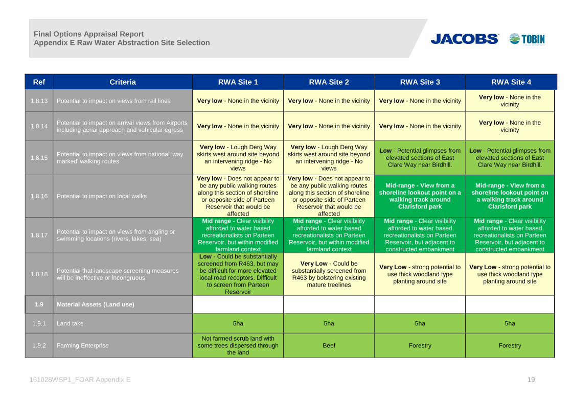
1.8.13 Potential to impact on views from rail lines Very low - None in the vicinity Very low - None in the vicinity Very low - None in the vicinity Very low - None in the
vicinity
1.8.14 Potential to impact on arrival views from Airports including aerial approach and vehicular egress
Very low - None in the vicinity Very low - None in the vicinity Very low - None in the vicinity Very low - None in the
vicinity
1.8.15 Potential to impact on views from national 'way marked' walking routes
Very low - Lough Derg Way
skirts west around site beyond an intervening ridge - No
views
Very low - Lough Derg Way
skirts west around site beyond an intervening ridge - No
views
Low - Potential glimpses from
elevated sections of East Clare Way near Birdhill.
Low - Potential glimpses from
elevated sections of East Clare Way near Birdhill.
1.8.16 Potential to impact on local walks
Very low - Does not appear to
be any public walking routes along this section of shoreline
or opposite side of Parteen Reservoir that would be
affected
Very low - Does not appear to
be any public walking routes along this section of shoreline
or opposite side of Parteen Reservoir that would be
affected
Mid-range - View from a shoreline lookout point on a
walking track around Clarisford park
Mid-range - View from a shoreline lookout point on
a walking track around Clarisford park
1.8.17 Potential to impact on views from angling or swimming locations (rivers, lakes, sea)
Mid range - Clear visibility
afforded to water based recreationalists on Parteen
Reservoir, but within modified farmland context
Mid range - Clear visibility
afforded to water based recreationalists on Parteen
Reservoir, but within modified farmland context
Mid range - Clear visibility
afforded to water based recreationalists on Parteen Reservoir, but adjacent to constructed embankment
Mid range - Clear visibility
afforded to water based recreationalists on Parteen Reservoir, but adjacent to constructed embankment
1.8.18 Potential that landscape screening measures will be ineffective or incongruous
Low - Could be substantially
screened from R463, but may be difficult for more elevated local road receptors. Difficult
to screen from Parteen Reservoir
Very Low - Could be
substantially screened from R463 by bolstering existing
mature treelines
Very Low - strong potential to
use thick woodland type planting around site
Very Low - strong potential to
use thick woodland type planting around site
1.9 Material Assets (Land use)
1.9.1 Land take 5ha 5ha 5ha 5ha
1.9.2 Farming Enterprise Not farmed scrub land with
some trees dispersed through the land
Beef Forestry Forestry

Final Options Appraisal Report Appendix E Raw Water Abstraction Site Selection
161028WSP1_FOAR Appendix E 20
Ref Criteria RWA Site 1 RWA Site 2 RWA Site 3 RWA Site 4
1.9.3 Number of landowners impacted within site boundary
1 2 2 2
1.9.4 Land Quality Poor to Medium Medium Medium Medium
1.9.5 Severance based on site location within overall land holdings
Individual farm impact to be evaluated when exact site
location decided
Individual farm impact to be evaluated when exact site
location decided
Individual farm impact to be evaluated when exact site
location decided
Individual farm impact to be evaluated when exact site
location decided
1.9.6 Potential Impacts on landholdings Loss of land, possible
severance and injurious affection
Loss of land, possible severance and injurious
affection
Loss of land, possible severance and injurious
affection
Loss of land, possible severance and injurious
affection
1.9.7 Crop rotation practiced No No predominately permanent
pasture No No
1.9.8 Overall Impact Low impact-slight at national
level
Low impact-slight at national
level
Low impact-slight at national
level
Low impact-slight at national
level
1.10 Tourism
1.10.1
Potential to impact on known tourism
amenities/facilities or Tourism Hotspots located
within 1km from site boundary.
Potential disturbance to water
based activities at this location
given the proposed
abstraction facility at the
indicated site location.
Potential disturbance to water
based activities at this location
given the proposed abstraction
facility at the indicated site
location.
Potential disturbance to water
based activities at this location
given the proposed
abstraction facility at the
indicated site location.
Potential disturbance to water
based activities at this
location given the proposed
abstraction facility at the
indicated site location.
1.11 Population
PEOPLES & COMMUNITIES
1.11.1 Number of residential & commercial buildings
300-500m from site boundary
A concentration of residential
receptors (c.27) in a linear
pattern located in close
proximity to the west of this
proposed abstraction site.
A concentration of residential
receptors (c.27) in a linear
pattern located in close
proximity to the west of this
proposed abstraction site.
A number of residential
receptors (c.10) in a linear
pattern located to the east of
this proposed abstraction site.
A number of residential
receptors (c.10) in a linear
pattern located to the east of
this proposed abstraction site.

Final Options Appraisal Report Appendix E Raw Water Abstraction Site Selection
161028WSP1_FOAR Appendix E 21
Ref Criteria RWA Site 1 RWA Site 2 RWA Site 3 RWA Site 4
1.11.3
Potential to impact on known community
amenities and facilities within 1km from site
boundary.
Site location for the proposed
WSP Abstraction Facility is
located away from any known
community amenities or
facilities.
Site location for the proposed
WSP Abstraction Facility is
located away from any known
community amenities or
facilities.
Site location for the proposed
WSP Abstraction Facility is
located away from any known
community amenities or
facilities.
Site location for the proposed
WSP Abstraction Facility is
located away from any known
community amenities or
facilities.
1.11.4 Potential to impact on areas of Significant
Population Densities
Site location for the proposed
WSP Abstraction Facility is
located away from any
significant population densities
Site location for the proposed
WSP Abstraction Facility is
located away from any
significant population densities
Site location for the proposed
WSP Abstraction Facility is
located away from any
significant population densities
Site location for the proposed
WSP Abstraction Facility is
located away from any
significant population
densities
1.12 Human Health
1.12.1 Human Health
Regardless of plant siting, all plant would be operated within
appropriate safeguards i.e. permissions and licences with
respect to human health to ensure that there are no
significant health risks to the population.
Regardless of plant siting, all plant would be operated within
appropriate safeguards i.e. permissions and licences with
respect to human health to ensure that there are no
significant health risks to the population.
Regardless of plant siting, all plant would be operated within
appropriate safeguards i.e. permissions and licences with
respect to human health to ensure that there are no
significant health risks to the population.
Regardless of plant siting, all plant would be operated
within appropriate safeguards i.e. permissions and licences with respect to human health to ensure that there are no
significant health risks to the population.
1.13 Soils, Geology and Hydrogeology
1.13.1 Aquifer Classification - importance of the groundwater resource to a given area
Ll/Pl Ll/Pl Mainly Ll Mainly Ll

Final Options Appraisal Report Appendix E Raw Water Abstraction Site Selection
161028WSP1_FOAR Appendix E 22
Ref Criteria RWA Site 1 RWA Site 2 RWA Site 3 RWA Site 4
1.13.2 Vulnerability Classification - potential for groundwater contamination
Moderate Vulnerability on specific site; impact of
necessary tunnelling works under Parteen Basin could be
significant
Moderate Vulnerability on specific site; impact of
necessary tunnelling works under Parteen Basin could be
significant
Classified as extreme however site geomorphology and soil exposes did not indicate the presence of shallow bedrock
Classified as extreme however site geomorphology
and soil exposes did not indicate the presence of shallow bedrock. Former
excavated pit for Parteen/Ardnacrusha
scheme.
1.13.3 GSI Groundwater Protection Response matrix N/A N/A N/A N/A
1.13.4 Groundwater Supplies - identification of water supply springs and bored wells based on GSI, EPA and FCC records
None identified None identified None identified None identified
1.13.5 Groundwater Source Protection Area's and Zones of Contribution as per available GSI & EPA data
None identified None identified None identified None identified
1.13.6 Potential to impact on Geological Heritage Sites / County Geological Sites
None identified None identified None identified None identified
1.13.7 Potential to interact with contaminated land None identified None identified None identified Former Borrow Pit
1.13.8 Potential to sterilise mineral resource N/A N/A N/A N/A
1.13.9 Potential to encounter shallow bedrock during construction (interactions with other disciples during construction - noise, dust etc)
Soil exposures indicated DTB>3m
Soil exposures indicated DTB>3m
Soil exposures indicated DTB>3m
Soil exposures indicated DTB>3m
1.13.10 Potential impact on karst features None identified None identified None identified None identified

Final Options Appraisal Report Appendix E Raw Water Abstraction Site Selection
161028WSP1_FOAR Appendix E 23
Ref Criteria RWA Site 1 RWA Site 2 RWA Site 3 RWA Site 4
1.13.11 Potential to encounter soft ground Soft, poorly drained soils and
peaty podzols present Soft, poorly drained soils and
peaty podzols present Well drained till, soft soils not
identified
Small areas of Soft, poorly drained soils and peaty
podzols present
1.13.12 Soils Types AMinPD, surface water/
groundwater gley AMinPD, surface water/
groundwater gley AMinPD, surface water/
groundwater gley AMinPD, surface water/
groundwater gley
1.13.13 Sub Soil Types TLPSSs TLPSSs
TLPSSs, clasts mainly of sandstone and
microconglomerate identified during site visit
TLPSSs, clasts mainly of sandstone and
microconglomerate identified during site visit
1.13.14 Depth to rock estimated >3m estimated >3m estimated >3m estimated >3m
2.0 Technical **
2.1 Safety
TRAFFIC
2.1.1 Length of access road required Mid-range Mid-range High Mid-range
2.1.2 Number of crossings required for access road Very Low Very Low Low Low
2.1.3 Potential Impact on landowners Mid-range Mid-range Mid-range Mid-range
2.1.4 Works required to provide safe access entrance Low Low Low Low
2.1.5 Potential impact on surrounding local road network
Mid-range Mid-range Low Low
2.1.6 Frequency of accidents near entrance Very Low Very Low Low Low

Final Options Appraisal Report Appendix E Raw Water Abstraction Site Selection
161028WSP1_FOAR Appendix E 24
Ref Criteria RWA Site 1 RWA Site 2 RWA Site 3 RWA Site 4
2.1.7 Frequency of accidents on surrounding network Very Low Very Low Low Low
2.1.8 Road link impacted upon by all construction traffic
Low Low Low Low
2.1.9 Construction Risk Very High Very High Low Low
2.2 Planning Policy
2.2.1 Planning Policy Clare County Development
Plan
Clare County Development
Plan
Tipperary County
Development Plan (North
Tipp)
Tipperary County
Development Plan (North
Tipp)
2.2.2 Existing Land Use Agricultural Agricultural Forestry Forestry
2.2.3 Zoning No Zoning No Zoning No Zoning No Zoning
2.2.4 Local Objectives N/A N/A N/A N/A
2.2.5 Other local objectives Lough Derg Study Lough Derg Study Lough Derg Study Lough Derg Study
2.2.6 Land Uses present in the vicinity Village of Killaloe
2.6km distance
Village of Killaloe
2.7km distance
Village of Birdhill
1.6km distance
Village of Birdhill
1.7km distance
2.2.7 Zoning present in the vicinity Killaloe Municipal District Plan Killaloe Municipal District Plan Birdhill Settlement Plan Birdhill Settlement Plan
2.2.8 Local objectives in the vicinity Protection of vistas to Lough
Derg
Protection of vistas to Lough
Derg
Protection of vistas to Lough
Derg
Protection of vistas to Lough
Derg
2.2.9 Other local objectives in the vicinity Scenic Route
Killaloe Municipal District Plan
Scenic Route
Killaloe Municipal District Plan Birdhill Settlement Plan Birdhill Settlement Plan
2.3 Engineering and Design

Final Options Appraisal Report Appendix E Raw Water Abstraction Site Selection
161028WSP1_FOAR Appendix E 25
Ref Criteria RWA Site 1 RWA Site 2 RWA Site 3 RWA Site 4
2.3.1 Proximity to effluent discharges 2.2km downstream of
Ballina/Killaloe treated effluent outfall
2.2km downstream of Ballina/Killaloe treated effluent
outfall
2.2km downstream of Ballina/Killaloe treated effluent
outfall
2.2km downstream of Ballina/Killaloe treated
effluent outfall
2.3.2 Constructability
Deep excavations adjacent to water body; likely to be strict environmental constraints; tunnelling under Parteen Basin required to reach
pipeline corridor
Deep excavations adjacent to water body; likely to be strict environmental constraints;
tunnelling under Parteen Basin required to reach pipeline
corridor
Deep excavations adjacent to water body; likely to be strict
environmental constraints
Deep excavations adjacent to water body; likely to be strict
environmental constraints
2.3.3 Process waste arising’s Occasional cleaning of
screens; debris from lake returned to lake
Occasional cleaning of screens; debris from lake
returned to lake
Occasional cleaning of screens; debris from lake
returned to lake
Occasional cleaning of screens; debris from lake
returned to lake
2.3.4 Power availability No power connection in
immediate vicinity No power connection in
immediate vicinity 38kV line in area; capacity
needs to be confirmed 38kV line in area; capacity
needs to be confirmed
2.4 Capital and Operational Costs
2.4.1 CAPEX €13.5m + €10.5m tunnelling
costs €13.5m + €10.5m tunnelling
costs €13.2m €13.2m
2.4.2 OPEX €366,000/annum (Labour,
pumping and capital replacement costs)
€366,000/annum (Labour, pumping and capital replacement costs)
€333,000/annum (Labour, pumping and capital replacement costs)
€333,000/annum (Labour, pumping and capital replacement costs)
Final Options Appraisal Report Appendix E Raw Water Abstraction Site Selection
161028WSP1_FOAR Appendix E 26
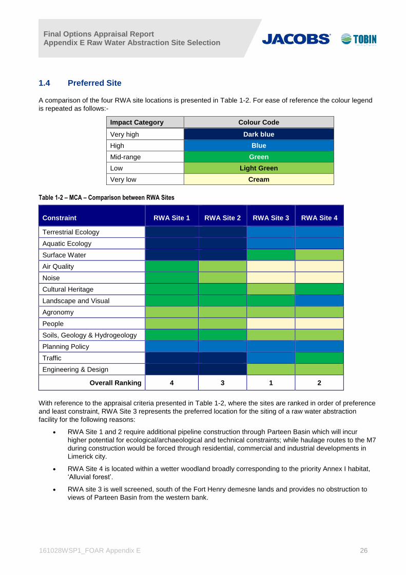
1.4 Preferred Site
A comparison of the four RWA site locations is presented in Table 1-2. For ease of reference the colour legend
is repeated as follows:-
Impact Category Colour Code
Very high Dark blue
High Blue
Mid-range Green
Low Light Green
Very low Cream
Table 1-2 – MCA – Comparison between RWA Sites
Constraint RWA Site 1 RWA Site 2 RWA Site 3 RWA Site 4
Terrestrial Ecology
Aquatic Ecology
Surface Water
Air Quality
Noise
Cultural Heritage
Landscape and Visual
Agronomy
People
Soils, Geology & Hydrogeology
Planning Policy
Traffic
Engineering & Design
Overall Ranking 4 3 1 2
With reference to the appraisal criteria presented in Table 1-2, where the sites are ranked in order of preference
and least constraint, RWA Site 3 represents the preferred location for the siting of a raw water abstraction
facility for the following reasons:
RWA Site 1 and 2 require additional pipeline construction through Parteen Basin which will incur
higher potential for ecological/archaeological and technical constraints; while haulage routes to the M7
during construction would be forced through residential, commercial and industrial developments in
Limerick city.
RWA Site 4 is located within a wetter woodland broadly corresponding to the priority Annex I habitat,
‘Alluvial forest’.
RWA site 3 is well screened, south of the Fort Henry demesne lands and provides no obstruction to
views of Parteen Basin from the western bank.

Final Options Appraisal Report Appendix E Raw Water Abstraction Site Selection
161028WSP1_FOAR Appendix E 27
2. Abstraction Location from POAR
The Parteen Basin emerged from the POAR as the preferred location for the abstraction of raw water to serve
the Eastern and Midlands Region; see Figure 2.1 below.
Figure 2.1 Parteen Basin –Potential Abstraction Area

Final Options Appraisal Report Appendix E Raw Water Abstraction Site Selection
161028WSP1_FOAR Appendix E 28
3. Screening to Identify Preliminary Sites
The screening for preliminary sites for raw water abstraction works at Parteen Basin is set out in this Section.
3.1 Technical Considerations
3.1.1 Rate of Abstraction
Raw water will be abstracted from Parteen Basin up to an ultimate rate of 330 Ml/day (3.82m3/s). Raw water
will be pumped from the abstraction location, via twin 1,500mm diameter rising mains, to the water treatment
plant site. The raw water rising mains will be cross connected to allow them to operate at first on a duty/standby
arrangement. However, as the abstraction rate grows, both rising mains will be required to convey raw water to
the treatment plant, each carrying an average 1.91m3/s.
3.1.2 Intake Screens
Parteen Basin itself forms part of the Lower River Shannon SAC. It will therefore be necessary to minimise, as
far as possible, the work required in the SAC to construct and operate a raw water abstraction facility. Water
abstraction through either a submerged pipeline or open channels, extending a relatively short distance out into
the basin, has been considered. In either case, protective screens will have to be fitted to the intakes to prevent
debris and/or juvenile fish or eels being taken up into the raw water pumps.
Migratory diadromous fish species are historically recognised as being at risk from raw water abstraction works
as they often have to pass numerous such water abstractions, as well as weirs and other hazards, on their
journeys between rivers and the sea. A primary constraint in the sizing and configuration of the intake and
protective screens will be the need to limit water velocities through the intake screens to 0.15m/s or less to
avoid fish entrapment.
Passive wedge-wire cylinder (PWWC) intake screens are a tried and tested solution and are widely regarded as
the best available technology for juvenile and larval fish protection at water intakes. In its most basic form, a
PWWC screen comprises a cylinder, formed of the wedge-wire material around its circumference, one end
being blanked off and flow being drawn off through the opposite end. The screen is then fitted as a tee-piece at
the head of the intake pipe.
PWWC screens have a number of features that make them suitable for prevention of fish entrainment. These
include a low through-slot velocity, allowing fish to swim away, the relatively smooth external presentation of the
screen, which reduces the risk of fish abrasion, and the narrow slot widths available, making it possible to
prevent entrainment of fish even down to egg or larval sizes. Also, the profile of the wedge wire forming the
screen surface is V-shaped, which offers low hydraulic resistance and reduces the risk of blockages building up
on the screen.
The screens are usually cleaned with an air blast backwash system in which a perforated pipe attached to the
screen is fed by an air compressor which can produce a turbulent burst of air, blowing off any debris on the
screen. Cleaning of the screen can be triggered automatically when a certain pressure differential is measured
between the inside and outside of the screen. Bio-fouling of screens, in particular with zebra mussel, which are
known to be present in Lough Derg/ Parteen Basin, can be greatly reduced through the use of a copper nickel
alloy rather than stainless steel in the manufacture of the screens.
3.1.3 Required Depth of Raw Water Abstraction Intake
Water levels in Parteen Basin are controlled by ESB within an operating band, measured on Lough Derg, from
30.40m OD to 30.86m OD (Malin Head); under certain conditions water levels can be up to 0.4m lower than
those recorded in Lough Derg. A raw water abstraction intake in Parteen Basin therefore will need to be set at
an invert level sufficiently lower than the minimum operating water level, taken to be 30.00m OD, to ensure that
water can be abstracted at the required rates even when water levels are at the lower end of the operating

Final Options Appraisal Report Appendix E Raw Water Abstraction Site Selection
161028WSP1_FOAR Appendix E 29
band. There is no evidence in the available raw water quality data to suggest that there would be any benefit
from locating an intake at greater than the minimum depth required to physically abstract water, nor is there any
evidence that varying the depth of the intake in the water column would be necessary.
In the case of a submerged pipeline intake, passive intake screens which would be fitted at the head of the pipe
can be selected so that intake velocities through the screen slots are limited to the required 0.15m/s. In an
open channel intake the depth of water within the channel and the width of the channel itself will dictate the
velocity generated for a given abstraction rate.
Considering firstly the submerged pipeline option, three 1,500mm diameter pipes would be provided, any two of
which would have the capacity to abstract the required 330 Ml/day. The head of each of the intake pipes would
be fitted with a passive surface water intake screen.
Abstracting water at a rate of 330Ml/day over 20 hours per day through any two screens would require each
screen to be capable of catering for flows up to 8,250m3/hour. The screens would be approximately 2,000 mm
in diameter and would need to be placed in the Basin such that there is a depth of at least half the diameter of
the screen (1,000 mm) above and below the screen. Taking the lowest operating level in Parteen Basin at
30.0m OD, then the crown of the intake screen would need to be at 29.0 m OD. The invert level of a 2,000 mm
diameter screen would therefore be at 27.0 m OD and, allowing for a 1,000 mm depth of water below the invert,
the screen would have to be placed at a location where the bed level is 26.0 m OD or lower.
An open channel intake would have to be sized on the basis that the flow generated in the channels by the
proposed abstraction of 330 Ml/day (3.82m3/s) would not exceed an average velocity of 0.15m/s. Twin
14,500mm wide rectangular channels, each capable of taking 50% of the required flow when the water level in
Parteen Basin is at the bottom of the ESB operating band, i.e. 30.0mOD, can fulfil this requirement at a water
depth in the channels of at least 1.6m. The invert of the channels would therefore have to be at 1.6m below
30.0m OD (28.4m OD) or lower. Vertical band screens could be used to prevent debris entering the raw water
pumping station but maintaining the required low velocities to prevent fish impingement on the screens would
be difficult. Minimum velocity through a fine mesh band screen would be in the order of 0.25m/s. Some
screens of this type incorporate a fish trap and return system where fish that come close to the screens are
scooped up in fish trays and deposited into channels flowing back into the source water.
An alternative would be to provide passive intake screens, such as those proposed for the pipe intake
configuration, in a sump on the head of the raw water pump suction pipes. In this configuration four screens
would be provided, each in a sump that can be isolated from the others to facilitate cleaning. The screens
would be cleaned in the same manner but dirt and debris from the cleaning operation could be drained from the
isolated sump and pumped to a lagoon or settling tank before being returned, if necessary through a filter, to
Parteen Basin.
3.1.4 Raw Water Abstraction Site Requirements
The raw water abstraction works will consist of the intake pipework or channels and a raw water pumping
station. It is expected that the raw water pumping station would be set back approximately 50m from the shore
line in order to minimise visual impacts.
The raw water pumping station itself will have a footprint of approximately 35m x 45m on plan and is likely to
have an overall height of 8m. The raw water pump house would incorporate the following:
Entrance Lobby
Pump Room
Control Room and Office
Workshop and Store

Final Options Appraisal Report Appendix E Raw Water Abstraction Site Selection
161028WSP1_FOAR Appendix E 30
Control Panel Room
Surge Vessel Room
MV Switch Room
ESB Substation
Kitchen & welfare facilities
Allowing for access roads and circulation and, in the case of an open channel intake, for lagoons or settlement
tanks for screen wash water returns, it is estimated that a site of approximately 2 ha will be required.
3.1.5 Feasibility of Abstraction from Ardnacrusha Headrace
The entrance area to the Ardnacrusha Headrace is an engineered channel between high engineering
embankments and is the western outlet of Parteen Basin. It is excluded from the designated footprint of the
Lower Shannon SAC. While water abstracted there would be visually more ‘identifiable’ as coming from water
associated with hydropower generation, it is not a substantive differential. It must be emphasized that water
abstracted from the Ardnacrusha Headrace is hydraulically equivalent to water abstracted at any of the other
locations within the lake, as discussed below. It draws from the normal operating water level range in just the
same way, and does so whether Ardnacrusha is operating, or not.
Construction of an intake downstream of the entrance gates to the headrace would also prejudice the ability of
ESB to isolate the headrace if it was ever necessary for maintenance, inspection, or engineering works.
In discussions with ESB, it has been emphasized that any engineering works proposed within the footprint of
the headrace canal and involving tunnelling works through or beneath the adjacent embankments or the dam
structure would have implications for the safety of the embankments and would not be acceptable to them. For
these reasons, the construction of an intake in the headrace has not been pursued.
3.1.6 Feasibility of Abstraction from Ardnacrusha Tailrace
The tailrace from Ardnacrusha station is tidal, and freshwater availability there is also variable, depending on
whether the station is generating, or not.
Continuous abstraction of approximately 4m3/s from the tailrace would require adaptation of generating practice
to continuously provide this amount of water into an area which would have to be partitioned against saline
intrusion. Such a discharge would be significantly at variance with the 100 m3/s rated output of one generator at
Ardnacrusha, and would not be feasible as a continuous flow.
A separate raw water storage which might be filled at times when Ardnacrusha was generating, and then drawn
from when generation had ceased, would have to be capable of balancing a daily water requirement of
approximately 0.33 million cubic metres, against intermittent inflows from generation, which during summer
months can be over short periods of the day. Such storage downstream of the Ardnacrusha power station would
be very substantial in scale and it would not be possible to locate and empty it within the tailrace itself. If it were
sited at higher level and adjacent, then any pumps and pipework to fill it would have to match the 100 m3/s rated
flow from a single generator, or else the pattern of generation would have to be adapted to accommodate a
smaller storage.
Such considerations underline why Ardnacrusha operations are balanced by the extensive area of the normal
operating water level band upstream in Parteen Basin/ Lough Derg, and why the operating band is of the
volume scale that it is.
In energy terms, allowing water to pass through the generators, and then pumping it from a lower level for water
supply, will always be less energy-efficient than abstracting the same water from the upstream side.

Final Options Appraisal Report Appendix E Raw Water Abstraction Site Selection
161028WSP1_FOAR Appendix E 31
It is concluded that abstraction from the tailrace is not practical or favoured as an option.
3.1.7 Feasibility of Co-Location with Clareville WTP
Co-location of the Water Treatment Plant for the WSP at the existing Clareville Water Treatment Plant, which
serves Limerick City and large areas of the county, would add an additional 13 - 15 km to the proposed treated
water pipeline length.
Abstraction of an additional 4 m3/s at Clareville could be achieved by increasing the minimum compensation
flow at the Parteen Weir to 14 m3/s, and allowing the water to flow to the Clareville intake, where the WSP
requirement would be abstracted, leaving the statutory compensation flow to progress past the intake.
Such an approach would involve a change to the flow management regime in the River Shannon section of the
Lower Shannon SAC, a change that is not required under direct abstraction from Parteen Basin. As a matter of
legal detail, it would also most likely require the abstraction to be progressed under the Water Supplies Act
1942, whereas abstraction from Parteen Basin would be progressed under the Local Government (Sanitary
Services) Act 1964. Where abstraction of a daily volume over 20 hours to avoid peak pumping tariffs be
envisaged at Clareville, this approach would necessarily use more water than direct abstraction from storage,
since river flow could not be flexibly varied to match changing abstraction rate over the day. It would have to be
released at the higher 20-hour abstraction rate, and over 4 hours in each day, this water would pass by the
intake.
In energy terms, allowing water to spill over Parteen Weir, and then pumping it from a lower level into Clareville
for water supply, followed by pumping through a higher elevation difference and longer pipeline to the Break
Pressure Tank will always be less energy-efficient than abstracting the same water from the upstream side of
the Weir.
3.2 Preliminary Screening of the Raw Water Abstraction Locations in Parteen Basin
Based on the preferred location at the Lower Lake, or Parteen Basin, a number of potential RWA areas were
initially identified, as presented in Figure 1.2, namely:
Western shore of Parteen Basin (RWA1)
Eastern shore of Parteen Basin (RWA2)
Eastern bank of River Shannon, immediately downstream of Lough Derg (RWA3)
A desktop consideration of each of these locations was carried out against the following criteria:
1. Topography: the surrounding topography should be low lying so as not to restrict the pipeline route and
minimise tunnelling
2. Proximity to environmentally sensitive designated sites: the abstraction location should avoid or
minimise impacts on designated sites, and avoid adverse effects on the qualifying interests and
conservation objectives of these sites.
3. Proximity to public roads: the abstraction location should preferably be in close proximity to an access
road
4. Proximity to existing residential development
5. Proximity to treated water route corridors: the abstraction location should be sited so as to afford
relatively easy access to the least constrained route corridor for the treated water transmission pipeline

Final Options Appraisal Report Appendix E Raw Water Abstraction Site Selection
161028WSP1_FOAR Appendix E 32
Table 3.1 summarises the initial assessment of the potential RWA areas.
Table 3-1 Summary Comparison of Potential Raw Water Abstraction Locations
Location RWA1
Western Shore
Location RWA2
Eastern Shore
Location RWA3
u/s Killaloe Bridge
Topography
ESB embankment extends
approximately 1,100m
upstream from Parteen
Weir. Natural shore north of
embankment at 30-31mOD
contour
ESB embankment extends
approximately 3,200m
upstream from Parteen
Weir. Natural shore north of
embankment at 30-31mOD
contour
Shore at 30mOD contour, but
rising relatively steeply to
public road at 45m OD.
Proximity to
Designated
Sites
Entire shoreline within
Lower River Shannon SAC
Entire shoreline within
Lower River Shannon SAC
Not within designated site;
extends 150m to 400m
downstream of Lough Derg
NHA boundary; approx.
1,200m upstream of Lower
River Shannon SAC
boundary.
Proximity to
Public Roads
R463 runs parallel to and
generally within 1km of
shoreline
R494 runs parallel to and
generally within 1km of
shoreline
Local residential roads run
adjacent to the location
Proximity to
existing
residential
development
Some ribbon development
along R463; low density
along shoreline
Some ribbon development
along R494; low density
along shoreline
Surrounded by residential
development
Proximity to
Emerging
Preferred
Corridor
Abstraction from western
shore would require a raw
water rising main tunnelled
beneath the river Shannon;
any site would need to be
north of ESB embankments
on both eastern and
western shores
Within 0.5km of least
constrained corridor
Approximately 3km north of
least constrained corridor;
routing of raw water rising
main would be very difficult
through Ballina and outskirts
3.2.1 Potential Raw Water Abstraction Sites on Parteen Basin Western Shoreline
In consideration of location RWA1 on the western shore of Parteen Basin, there are lands available that could
accommodate a raw water abstraction facility. However, crossing the river Shannon with a rising main from an
abstraction point on the western shore of the lake to the least constrained pipeline corridor, east of the basin,
would require tunnelling beneath the Parteen Basin which would be difficult and costly. The eastern shoreline is
heavily constrained (see assessment below) and any tunnelling operation from the western shore would need to
run north of the ESB embankments and south of residential properties along the eastern shore. There are lands
potentially available for abstraction works along the north western shore, circled in ‘red’ in Figure 3.1. These
are the two areas that are (a) sufficiently far north to allow tunnelling to the eastern shore and avoid the ESB
embankment and (b) are a reasonable distance (more than 150m) from existing housing.
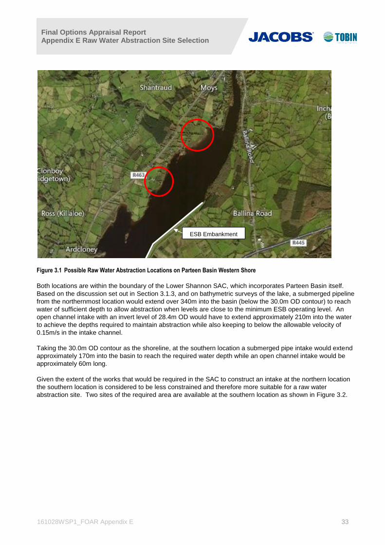
Final Options Appraisal Report Appendix E Raw Water Abstraction Site Selection
161028WSP1_FOAR Appendix E 33
Figure 3.1 Possible Raw Water Abstraction Locations on Parteen Basin Western Shore
Both locations are within the boundary of the Lower Shannon SAC, which incorporates Parteen Basin itself.
Based on the discussion set out in Section 3.1.3, and on bathymetric surveys of the lake, a submerged pipeline
from the northernmost location would extend over 340m into the basin (below the 30.0m OD contour) to reach
water of sufficient depth to allow abstraction when levels are close to the minimum ESB operating level. An
open channel intake with an invert level of 28.4m OD would have to extend approximately 210m into the water
to achieve the depths required to maintain abstraction while also keeping to below the allowable velocity of
0.15m/s in the intake channel.
Taking the 30.0m OD contour as the shoreline, at the southern location a submerged pipe intake would extend
approximately 170m into the basin to reach the required water depth while an open channel intake would be
approximately 60m long.
Given the extent of the works that would be required in the SAC to construct an intake at the northern location
the southern location is considered to be less constrained and therefore more suitable for a raw water
abstraction site. Two sites of the required area are available at the southern location as shown in Figure 3.2.
ESB Embankment

Final Options Appraisal Report Appendix E Raw Water Abstraction Site Selection
161028WSP1_FOAR Appendix E 34
Figure 3.2 Possible Raw Water Abstraction Sites on Parteen Basin Western Shore
3.2.2 Raw Water Abstraction Sites on Parteen Basin Eastern Shoreline
The ESB will not permit works that require a pipeline to be constructed through or under the embankments that
were constructed in the 1920’s in the formation of Parteen Basin. Therefore, abstraction works cannot be
located along the shore line where ESB embankments are in place and an abstraction point along the eastern
shoreline of the basin would need to be located to the north of the ESB embankment.
The outskirts of the town of Ballina extend to the very north eastern corner of Parteen Basin, with residential
properties occupying the shoreline northward from a point approximately 1,100m upstream of the extent of the
ESB embankment. Figure 3.3 shows the extent of eastern shoreline, north of the ESB embankment and south
of Ballina that may provide a feasible location for abstraction works.

Final Options Appraisal Report Appendix E Raw Water Abstraction Site Selection
161028WSP1_FOAR Appendix E 35
Figure 3.3 Possible Raw Water Abstraction Location on Parteen Basin Eastern Shore
From an initial examination of aerial photography of the possible abstraction location site shown in Figure 3.4, it
was recognised that the wooded eastern shoreline extending north of the ESB embankment comprised semi-
natural woodland designated within the SAC. A site visit conducted in December 2015, and subsequent
ecological surveys, took cognisance of the potential for alignment with the priority Annex I habitat Alluvial
Woodland for which the SAC is designated. This would have implications for the siting of raw water abstraction
works within such habitat. It is noted that the Killaloe/ Ballina road by-pass project has not yet received planning
permission due to a disputed area of alluvial woodland. It is considered that any proposals to site the
abstraction works in this area, whether the woodlands are categorically classified as comprising priority Annex I
Alluvial Woodland or not, will run a high risk of being challenged. Based on the December 2015 walkover
survey by engineering and ecology specialists , followed by the additional ecological surveys during May and
June 2016, it was noted that the woodland along the shoreline extending approximately 120m immediately north
of the embankment, is in fact predominantly coniferous plantation and mixed-broadleaved woodland, not
corresponding to priority Annex I Alluvial Woodland habitat. Provision of additional expert opinion on the
classification of this habitat area has been recommended by NPWS divisional ecologists and this is in process.
ESB
Embankments
Possible
abstraction
location
Outskirts Ballina

Final Options Appraisal Report Appendix E Raw Water Abstraction Site Selection
161028WSP1_FOAR Appendix E 36
Figure 3.4 Classification of Woodlands on Parteen Basin Eastern Shore
Given the constraints of the ESB embankments, the potential for disputes regarding alluvial woodland habitat
classification and the development north of the woodlands associated with the outskirts of Ballina, the preferred
location for an abstraction point on the eastern shore of Parteen Basin is the 120m shoreline between the
northern extents of the embankment at the southern extent of the natural woodlands.
This site is at an elevation of slightly greater than 31m OD along the shoreline; ground levels between the site
and the R494 public road to the east are relatively flat, estimated to be between 31m and 33m OD. It is
proposed at this stage that the raw water pumping station required to deliver water to a water treatment plant
should be sited adjacent to the abstraction point. An access road to the site would have to be constructed from
the R494, a distance of between 900m and 980m, depending upon the route taken. There are however no local
roads to be crossed between the site and the R494, nor are there any buildings or significant developments that
would make an access road route difficult.
Two potential sites of the required area were identified on the eastern shore, as shown in Figure 3.5.
Parteen Basin
embankment
Low grade
woodland
Potential alluvial
woodland

Final Options Appraisal Report Appendix E Raw Water Abstraction Site Selection
161028WSP1_FOAR Appendix E 37
Figure 3.5 Potential Raw Water Abstraction Sites on Parteen Basin Eastern Shore
3.2.3 Raw Water Abstraction Site North of Killaloe Bridge
Location RWA3 in Figure 1.2, while avoiding works within a designated site, is essentially locked in by existing
development. A feasible pipe route to transfer water from this location to the emerging preferred corridor is not
available unless existing properties were acquired and housing demolished to accommodate the construction.
Therefore, this option was not considered further.
3.3 Screening Conclusion
The consideration of local constraints along the shoreline of the Parteen Basin area has identified four
preliminary sites that are conducive to the siting and effective operation of the Raw Water Abstraction Works.
These have been subject to MCA analysis; discussed in the following sections of this report.

Final Options Appraisal Report Appendix E Raw Water Abstraction Site Selection
161028WSP1_FOAR Appendix E 38
4. RWA Site 1 (Western Shore)
RWA Site 1 is located on the western shore of the Parteen Basin, due east of the village of Bellisle and regional
road R463; see Figure 4.1.
Figure 4.1 – RWA Site 1
The analysis undertaken by each of the project specialists is presented below.
(i) Ecology
The RWA Site 1 is located partially within the Lower River Shannon SAC (002165) and would require
construction works within the designation along the lake shore and fringing wetland habitat. Selection of this site
for raw water abstraction would also require the construction of a raw water pipeline crossing of Parteen Basin,
resulting in additional works within the SAC. This site is located on extensively managed grassland habitat and
has a very low likelihood of additional Annex I habitats occurring.
No protected flora species were recorded and the potential of occurrence was evaluated as ‘low’; therefore, no
species listed on the Flora Protection Order are expected to occur. The Annex II Otter, listed as a qualifying
interest of the SAC, occurs along the lakeshore within the footprint of this site, but no dwellings were recorded
during site visits. The proposed pipeline crossing of Parteen Basin, required of this site, would likely increase
the potential for effects on Otter. Additional Annex II species are unlikely to occur within this site. Otter and all
bat species are also listed as Annex IV species. These species use and are likely to use this site.
No SPA designations were recorded within or adjacent to this site. The wet grassland habitat at RWA Site 1 is
unsuitable for wintering bird species and has low breeding bird potential. Bird species that occur within this site,
will however be potentially affected. No flora or fauna protected under the Wildlife Act 1979 (Amendment 2000)
were found to occur at this site but the Common Frog is likely to occur.

Final Options Appraisal Report Appendix E Raw Water Abstraction Site Selection
161028WSP1_FOAR Appendix E 39
There is no connectivity to salmonid or freshwater pearl mussel watercourses or no potential effects on coastal
or marine receptors; however, Parteen Basin is designated as an SAC for Annex II Atlantic Salmon. Protected
aquatic flora may occur within the littoral and/or benthic zone(s). Construction and operation of a raw water
abstraction works within the lake may potentially impact upon high quality aquatic habitat for protected aquatic
species. In addition, a proposed pipeline crossing of the lake will increase potential for effects on high quality
aquatic habitat supporting protected aquatic species. Further project and survey information may help reduce
the significance of these impacts.
(ii) Aquatic Ecology
The use of this site, where a raw water pipeline is tunnelled under the lake from the western shore to the east,
would result in increased potential for significant impacts on the high value lacustrine littoral and benthic habitat
within the SAC.
No aquatic Annex IV species are likely to be affected by the proposed RWA Site 1. Benthic survey results have
not yet been analysed but there is a very low likelihood of additional Annex I habitats occurring. There is also a
very low likelihood of additional protected aquatic flora species occurring.
Breeding and wintering water birds were recorded in the lake waterbody and wider study area. A pipeline
crossing of the lake would increase potential for disturbance effects on the wetland habitats supporting these
breeding and wintering water birds.
Aquatic species protected under the Wildlife Act 1979 (Amendment 2000) include fish species (Brown Trout,
Atlantic Salmon), water birds and the Common Frog, all of which occur within the lake and in the vicinity of RWA
Site 1. A pipeline crossing of the lake would increase potential for effects on high quality aquatic habitat
supporting protected aquatic species.
There is no connectivity to salmonid or freshwater pearl mussel watercourses or no potential effects on coastal
or marine receptors; however, Parteen Basin is designated as an SAC for Annex II Atlantic Salmon and Otter.
Protected aquatic flora may occur within the littoral and/or benthic zone(s). Construction and operation of a raw
water abstraction facility within Parteen Basin may potentially impact upon high quality aquatic habitat for
protected aquatic species. In addition, the requirement to construct a raw water pipeline in the lake also
increases the potential for effects on high quality aquatic habitat supporting protected aquatic species. The
potential for significant impacts affecting aquatic ecological receptors is evaluated as ‘very high’. The potential
for significant impacts on coastal and marine aquatic ecological receptors is identified as ‘very low’. Further
project and survey information may help reduce the significance of these impacts.
(iii) Surface Water
Table 4-1 details the Water Framework Directive (WFD) water bodies within the area of RWA Site 1.
Table 4-1 RWA Site 1 WFD Watercourses
Waterbody Name Waterbody Type EU WFD Code WFD Status
(2010-2012)
Lough Derg pHMWB Lake IE_SH_25_191b High
There are a number of WFD related protected areas within and adjacent to the location as follows:
The entirety of Lough Derg (including Parteen Basin) is classified under the WFD as being Drinking
Water and a Nutrient Sensitive Area; and
The Lower River Shannon SAC [002165].

Final Options Appraisal Report Appendix E Raw Water Abstraction Site Selection
161028WSP1_FOAR Appendix E 40
The sensitivity of the Parteen Basin location is rated as ‘High’ due to the number of WFD related protected
areas.
There is also the possibility of some fluvial flooding to 1% Annual Exceedance Probability (AEP)2 within 100m of
the site.
(iv) Air Quality
The focus of the assessment consisted of determining the potential for dust emissions to occur during the
construction phase of the proposed development as there is unlikely to be any significant impacts to occur
during the operational phase. The potential for dust emissions is directly related to the distance between the site
and the nearest residential receptors. Receptors which are closer to the site have a higher risk of experiencing
dust impacts during the construction phase. The proposed site is approximately 140m from the nearest
sensitive receptor, with the longer the distance being the most preferable from an air quality point of view.
(v) Noise
The focus of the assessment consisted of determining the potential for noise/vibration emissions to occur during
the construction and operational phase of the proposed development. The potential for noise/vibration
emissions is directly related to the distance between the site and the nearest residential receptors. Receptors
which are closer to the site have a higher risk of experiencing noise/vibration impacts during the
construction/operational development phases. The proposed site is approximately 140m from the nearest
sensitive receptor, with the longer the distance being the most preferable from a noise point of view.
(vi) Cultural Heritage
There is no recorded archaeological, built heritage or cultural heritage sites located within the vicinity of this site.
As such the impact has been defined as very low. However, when considering the fact that a pipeline will have
to be tunnelled from the site to the eastern shore of Parteen Basin, this has more potential to impact on
previously unrecorded archaeological remains and has to be considered as part of the assessment of the
options.
(vii) Landscape and Visual
The site is in an area of marginal grassland and scrub. The R463 runs parallel to Parteen Basin a short distance
uphill to the west of RWA1 and it is designated as a scenic route along this section. There is also a more
elevated local road further upslope that is lined by dwellings that take advantage of elevated panoramic views
over the lake. The popular tourist settlements of Killaloe/ Ballina lie just over 2km to the north on either side of
the River Shannon. Clarisford Park recreational area lies between this site and the settlement of Killaloe and
also occupies the shores of the lake.It is contained within a sensitive ‘Heritage Landscape’ area designation in
the Clare County Development Plan (2011-2017).
(viii) Agronomy
Farm Enterprise
The subject site is not currently in agricultural production. The site is in grassland and it is currently in an
overgrown condition; encroached by scrub. Some native trees are dispersed throughout the site. There are no
farm buildings located within the site boundary.
Number of Landowners impacted within the site boundary
According to folio data supplied by the land registry there is one land owner within the site boundary.
2 The AEP is the estimated likelihood of a particular magnitude flood occurring or being exceeded in any given year. Thus, a 1% AEP event
represents an estimated flood event which has a 1% (or 1 in 100) chance of occurring or being exceeded in any given year.

Final Options Appraisal Report Appendix E Raw Water Abstraction Site Selection
161028WSP1_FOAR Appendix E 41
Land Quality
According to the Environmental Protection Agencies (EPAs) Soil Classification of Ireland, the soils in the region
consist in the main of a fine loamy drift with siliceous stones. The soils are particularly suited to grassland. In
addition the land is adjacent to the western bank of the lake and would be prone to flooding which could restrict
its use. The land quality is considered to be poor to medium quality land.
Crop Rotation Practised
The land is in grassland and is not currently in agricultural production. Crop rotation is not practised.
(ix) People
There are a significant number of residential receptors (approximately 10) in a linear pattern, located on the
western side of the R463. There is also a residential receptor located on the eastern side of the R463 in close
proximity to the site (approximately 120m) as well as a commercial receptor to the immediate south-west in the
form of agricultural sheds/facilities. There are no tourism amenities/hotspots within 500m of this proposed
abstraction site. An access track from the R463 would be required to provide access to the site.
(x) Soils, Geology and Hydrogeology
The site is mapped3 as deep, poorly drained, mineral soil, derived mainly from non-calcareous parent materials
and belonging to the soil groups Surface water/Groundwater gleys (AminPD). An area of lacustrine deposits is
mapped along the lake shoreline. The vulnerability of the site is classified as ‘moderate’ vulnerability based on
GSI data.
A site visit was undertaken in July 2016. Soils on site comprise soft to firm, moist, light brown, sandy gravelly
Clay with occasional siltstone, sandstone and micro conglomerate cobbles. Peat is located to the north and east
of the site. Along part of the foreshore minor shore protection berms are in place. The berms are less than 0.4m
and constructed of soil and timber to prevent erosion. The site is classified as ‘moderate’ vulnerability based on
the GSI data.
The bedrock map indicates that the site is underlain by Dinantian (early) Sandstones, Shales and Limestones.
Dinantian Lower Impure Limestones are mapped to the south of the site. No outcrops of these rocks within the
site.
There are no geological heritage sites or source protection zones located within 1 km of the site. It is a green
field site with negligible potential for encountering soil contamination. There are no active quarries or pits on or
immediately adjacent to the site.
(xi) Planning Policy
Land Use Zoning
The site is located within the functional area of Clare County Council. The lands are currently unzoned.
Local objectives
There are no specific local objectives for the site.
Other Objectives
It is noted that there is a scenic route identified to the north west of the site.
3 Information regarding the soil classifications was obtained from the EPA web-mapping site, containing soil information from the Teagasc/EPA soil &
subsoil mapping project.

Final Options Appraisal Report Appendix E Raw Water Abstraction Site Selection
161028WSP1_FOAR Appendix E 42
Overview of Potential Planning Issues
The site is located in an area of unzoned lands. There are no specific local objectives pertaining to the site itself
or within the immediate vicinity of the site. The site is located outside of the environs of the settlements in the
area. There is a recognised scenic route running to the north east of the site; care must be taken with any
potential siting of any infrastructure within this site.
(xii) Traffic, Engineering and Design
The site is accessed via a series of regional routes with connectivity to the M7 Motorway to the east and the
N18 national route to the south.
While the M7 motorway is situated to the east of Lough Derg, access to the motorway via Killaloe/ Ballina is
restricted due to the requirement for vehicles to travel through Killaloe village and onto the R494 in Ballina via a
narrow bridge (with signalised traffic control to facilitate vehicular movements across the bridge which is limited
to one traffic lane).
The alternative route to the M7, along the R463 road will result in travel southwards to Ardnacrusha, through
Limerick City, via the Corbally, Garryowen and Galvone areas, and onto the M7 at Junction 30. This would
require all traffic to travel through Limerick City and negotiate 90 degree bends, and residential, commercial and
industrial development areas. Travel distance from the site to Junction 30 on the M7 Motorway is approximately
29km.
The R463 regional route comprises a carriageway cross section of two 3.0m wide traffic lanes with a 250mm
hard strip to both sides. Pavement and road marking conditions along the R463 are fair with some evidence of
pavement degradation in the form of surface cracks.
A total of six domestic properties are situated within the immediate vicinity of the proposed site access junction.
The proposed access is sited within the existing 60km/h urban transition zone.
The Road Safety Authorities Collision Statistics database has no recorded collisions in the vicinity of the
proposed access location.

Final Options Appraisal Report Appendix E Raw Water Abstraction Site Selection
161028WSP1_FOAR Appendix E 43
5. RWA Site 2 (Western Shore)
RWA Site 2 is located on the western shore of Parteen Basin, near the village of Bellisle and connecting
regional road R463; see Figure 5.1.
Figure 5.1 – RWA Site 2
(i) Ecology
The RWA Site 2 is located partially within the Lower River Shannon SAC (002165) and would require
construction works within the designation along the lake shore and fringing wetland habitat. As with RWA Site 1,
selection of this site would also require a raw water pipeline crossing of Parteen Basin, resulting in additional
works within the SAC. This site is located on extensively managed grassland habitat and has a very low
likelihood of additional Annex I habitats occurring.
No protected flora species were recorded and the potential of occurrence was evaluated as ‘low’; therefore, no
species listed on the Flora Protection Order are expected to occur. The Annex II Otter, listed as a qualifying
interest of the SAC, occurs along the lakeshore within the footprint of this site; however, during site visits, no
dwellings were recorded on the site. A proposed pipeline crossing of the lake would likely increase the potential
for effects on Otter. Additional Annex II species are unlikely to occur within this site. Otter and all bat species
are also listed as Annex IV species. These species use and are likely to use this site.
No SPA designations were recorded within or adjacent to this site. The managed wet grassland habitat is
suitable for wintering Annex I birds (e.g. Whooper Swan, Greylag Geese) and has breeding bird potential. Bird
species that occur within this site will likely be affected. No flora or fauna protected under the Wildlife Act 1979
(Amendment 2000) were found to occur at this site, but the Common Frog is likely to occur.
There is no connectivity to salmonid or freshwater pearl mussel watercourses or no potential effects on coastal
or marine receptors; however, Parteen Basin is designated as an SAC for Annex II Atlantic Salmon. Protected

Final Options Appraisal Report Appendix E Raw Water Abstraction Site Selection
161028WSP1_FOAR Appendix E 44
aquatic flora may occur within the littoral and/or benthic zone(s). Construction and operation of a raw water
abstraction works within the lake may potentially impact upon high quality aquatic habitat for protected aquatic
species. In addition, the proposed pipeline crossing of the lake will increase potential for effects on high quality
aquatic habitat supporting protected aquatic species. Further project and survey information may help reduce
the significance of these impacts.
(ii) Aquatic Ecology
The site is also located partially within the Lower River Shannon SAC (002165) site boundary and would require
construction works within the designation. As with RWA Site 1, the use of this site would require a raw water
pipeline to be tunnelled under the lake from the western shore to the east, resulting in increased potential for
significant impacts on the high value lacustrine littoral and benthic habitat within the SAC.
No aquatic Annex IV species are likely to be affected by the proposed site. Benthic survey results have not yet
been analysed but there is a very low likelihood of additional Annex I habitats occurring. There is also a very low
likelihood of additional protected aquatic flora species occurring.
Breeding and wintering water birds were recorded in the lake waterbody and wider study area. A pipeline
crossing of Parteen Basin would increase potential for disturbance effects on the wetland habitats supporting
these breeding and wintering water birds.
Aquatic species protected under the Wildlife Act 1979 (Amendment 2000) include fish species (Brown Trout,
Atlantic Salmon), water birds, and the Common Frog all of which occur within the lake and in the vicinity of the
site. A raw water pipeline crossing underneath the lake would increase potential for effects on high quality
aquatic habitat supporting protected aquatic species.
There is no connectivity to salmonid or freshwater pearl mussel watercourses, nor are there any potential
effects on coastal or marine receptors; however, Parteen Basin is designated as an SAC for Annex II Atlantic
Salmon and Otter. Protected aquatic flora may occur within the littoral and/or benthic zone(s). Construction and
operation of a raw water abstraction facility within the lake may potentially impact upon high quality aquatic
habitat for protected aquatic species. In addition, a raw water pipeline crossing underneath the lake will also
increase potential for effects on high quality aquatic habitat supporting protected aquatic species. The potential
for significant impacts affecting aquatic ecological receptors is evaluated as ‘very high’. The potential for
significant impacts on coastal and marine aquatic ecological receptors is identified as ‘very low’. Further project
and survey information may help reduce the significance of these impacts.
(iii) Surface Water
Table 5-1 details the WFD water bodies within the area of RWA Site 2.
Table 5-1 RWA Site 2 WFD Watercourses
Waterbody Name Waterbody Type EU WFD Code WFD Status
(2010-2012)
Lough Derg pHMWB Lake IE_SH_25_191b High
There are a number of WFD related protected areas within and adjacent to the location as follows:
The entirety of Lough Derg (including Parteen Basin) is classified under the WFD as being Drinking
Water and a Nutrient Sensitive Area; and
The Lower River Shannon SAC [002165].

Final Options Appraisal Report Appendix E Raw Water Abstraction Site Selection
161028WSP1_FOAR Appendix E 45
The sensitivity of the location is rated as ‘High’ due to the number of WFD related protected areas.
There is also the possibility of some fluvial flooding to 1% AEP within 100m of the site.
(iv) Air Quality
The focus of the assessment consisted of determining the potential for dust emissions to occur during the
construction phase of the proposed development as there is unlikely to be any significant impacts to occur
during the operational phase. The potential for dust emissions is directly related to the distance between the site
and the nearest residential receptors. Receptors which are closer to the site have a higher risk of experiencing
dust impacts during the construction phase. The proposed site is approximately 240m from the nearest
sensitive receptor, with the longer the distance being the most preferable from an air quality point of view.
(v) Noise
The focus of the assessment consisted of determining the potential for noise/vibration emissions to occur during
the construction and operational phase of the proposed development. The potential for noise/vibration
emissions is directly related to the distance between the site and the nearest residential receptors. Receptors
which are closer to the site have a higher risk of experiencing noise/vibration impacts during the
construction/operational development phases. The proposed site is approximately 240m from the nearest
sensitive receptor, with the longer the distance being the most preferable from a noise perspective.
(vi) Cultural Heritage
There is no recorded archaeological, built heritage or cultural heritage sites located within the vicinity of this site.
As such the impact potential has been defined as very low. However, when considering the fact that a pipeline
will have to be tunnelled from the site to the eastern shore of the lake, this has more potential to impact on
previously unrecorded archaeological remains and has to be considered as part of the assessment of the
options. On this basis, this site and RWA 1 are considered to be least preferable when compared to sites that
do require a lake crossing.
(vii) Landscape and Visual
The land cover of the site is rough grazing lakeside farmland. A number of tree-lined hedgerows are contained
within and around the site. The R463 runs parallel to the lake a short distance uphill to the west of RWA2 and it
is designated as a scenic route along this section. There is also a more elevated local road further upslope that
is lined by dwellings that take advantage of elevated panoramic views over the lake. The popular tourist
settlements of Killaloe/ Ballina lie just over 2km to the north of the site on either side of the River Shannon.
Clarisford Park recreational area lies between this site and the settlement of Killaloe and also occupies the
shores of Parteen Basin. The site is also contained within the sensitive ‘Heritage Landscape’ area designation
in the Clare County Development Plan (2011-2017)
(viii) Agronomy
Farm Enterprise
The site is currently in grassland and is used for a beef enterprise. There are no farm buildings located within
the site boundary. The site area encompasses a number of fields with varying sizes separated by mature
hedgerows.
Number of Landowners impacted within the site boundary
According to folio data supplied by the land registry there are two land owners within the site boundary.
Land Quality

Final Options Appraisal Report Appendix E Raw Water Abstraction Site Selection
161028WSP1_FOAR Appendix E 46
According to the EPAs Soil Classification of Ireland, the soils in the region consist in the main of a fine loamy
drift with siliceous stones. The soils are particularly suited to grassland. In addition the land is adjacent to the
Western bank of Parteen Basin and would be prone to flooding which could restrict its use none the less the
land is suitable for agricultural production and is used for grazing. The land quality is considered to be medium
quality land.
Crop Rotation Practised
The land is in grassland and it is likely that crop rotation is not practised and that the land is in permanent
pasture.
(ix) People
The site is located adjacent to a commercial farm and its associated building, and is approximately 220m south-
east of linear patterned residential receptors. An access to the site would be expected to be located away from
these residential receptors along the linear treeline and southern boundary of the site.
(x) Soils, Geology and Hydrogeology
The site is mapped4 as deep, poorly drained, mineral soil, derived mainly from non-calcareous parent materials
and belonging to the soil groups Surface water/ Groundwater gleys (AminPD). Lacustrine soil is mapped along
the lake shoreline.
A site visit was undertaken in July 2016. Soils at the site are comprised of soft to moderately firm, moist, grey to
light brown, sandy gravelly Clay. Occasional sand and sandy silt horizons were noted towards the shoreline. A
small area of peat (>1m) is located along the foreshore. Shore protection measures (<0.4m) were constructed
of soil and timber to prevent erosion. Large sandstone erratic was noted to the east of the site. The site is
classified as ‘moderate’ vulnerability based on the GSI data.
The bedrock map indicates that the site is underlain by Dinantian (early) Sandstones, Shales and Limestones
and Dinantian Lower Impure Limestones. No bedrock outcrops were noted on the site.
There are no geological heritage sites or source protection zones located within 1 km of the site. The site is a
green field site with negligible potential for encountering soil contamination. There are no active quarries or pits
on or immediately adjacent to the site.
(xi) Planning Policy
Land Use Zoning
The site is located within the functional area of Clare County Council. The lands are currently unzoned.
Local objectives
There are no specific local objectives for the site.
Other Objectives
It is noted that there is a scenic route identified to the north west of the site.
Overview of Potential Planning Issues
The site is located in an area of unzoned lands. It is currently in agricultural use and is surrounded by other
agricultural lands. There are no specific local objectives pertaining to the site itself or within the immediate
4 Information regarding the soil classifications was obtained from the EPA web-mapping site, containing soil information from the Teagasc/EPA soil &
subsoil mapping project.

Final Options Appraisal Report Appendix E Raw Water Abstraction Site Selection
161028WSP1_FOAR Appendix E 47
vicinity of the site. The site is located outside of the environs of the settlements in the area. There is a
recognised scenic route running to the north east of the site; care must be taken with potential siting of any
infrastructure within this site.
(xii) Traffic, Engineering and Design
The site area is accessed via a series of regional routes within connectivity to the M7 Motorway to the east and
the N18 national route to the south.
As with RWA Site 1, access to the M7 motorway via Killaloe/Ballina and the R494 regional road is restricted by
the narrow bridge across the Shannon at Killaloe which signalised and restricted to one lane traffic.
Again, the alternative route from the site, south along the R463 regional road will result in travel through the
Corbally, Garryowen and Galvone areas of Limerick City, to access the M7 at Junction 30, some 23km travel
distance from RWA Site 2.
The R463 regional comprises a carriageway cross section of two 3.0m wide traffic lanes with a 250mm hard
strip to both sides. Pavement and road marking conditions along the R463 are fair with some evidence of
pavement degradation in the form of surface cracks.
Site access would be within the existing 80km/h rural speed limit zone. Visibility at the site can be improved.
However, due to the physical constraints resulting from the dip in the carriageway alignment, visibility splays in
accordance with the development plan may not be achievable.
The Road Safety Authorities Collision Statistics database has no recorded collisions in the vicinity of the
proposed access location.

Final Options Appraisal Report Appendix E Raw Water Abstraction Site Selection
161028WSP1_FOAR Appendix E 48
6. RWA Site 3 (Eastern Shore)
RWA Site 3 is located on the eastern shore of Parteen Basin, west of the R494 and just north of the existing
ESB embankments within a considerable forest and agricultural land bank; see Figure 6.1.
Figure 6.1 – RWA Site 3
(i) Ecology
The RWA Site 3 is within a mixed broadleaved woodland and coniferous plantation and is partially located
within the Lower River Shannon SAC boundary. The mixed broadleaved woodland within the site does not
correspond to Annex I habitat. The site would require construction works within the SAC designation.
No protected flora species were recorded and the potential of occurrence was evaluated as ‘low’; therefore, no
species listed on the Flora Protection Order are expected to occur. The Annex II Otter, listed as a qualifying
interest of the SAC, occurs along the lakeshore within the footprint of this site, but no dwellings were recorded
at this location during site visits. Additional Annex II species are unlikely to occur within this site. Otter and all
bat species are also listed as Annex IV species. These species use and are likely to use this site. The bat
potential at this site is higher within the woodland habitat.
No SPA designations were recorded within or adjacent to this site. The woodland habitat is unsuitable for
wintering bird species and has low breeding bird potential; however, evidence of short-eared owl was recorded.
Bird species that occur within this site will likely be affected. Evidence of badger activity was also recorded
within this site. Other flora or fauna protected under the Wildlife Act 1979 (Amendment 2000) that are likely to
occur include the Pine Marten and Common Frog.
There is no connectivity to salmonid or freshwater pearl mussel watercourses or no potential effects on coastal
or marine receptors; however, Parteen Basin is designated as an SAC for Annex II Atlantic Salmon. Protected

Final Options Appraisal Report Appendix E Raw Water Abstraction Site Selection
161028WSP1_FOAR Appendix E 49
aquatic flora may occur within the littoral and/or benthic zone(s). Construction and operation of a raw water
abstraction works within the lake may potentially impact upon high quality aquatic habitat for protected aquatic
species. Further project and survey information may help reduce the significance of these impacts.
(ii) Aquatic Ecology
The site is located partially within the Lower River Shannon SAC (002165) site boundary. This site would
require construction works within the designation which will potentially affect the high value lacustrine littoral and
benthic habitat within the SAC.
No aquatic Annex IV species are likely to be affected by the proposed site. Benthic survey results have not yet
been analysed but there is a very low likelihood of additional Annex I habitats occurring. There is also a very low
likelihood of additional protected aquatic flora species occurring.
Breeding and wintering water birds were recorded in the lake waterbody and wider study area. Aquatic species
protected under the Wildlife Act 1979 (Amendment 2000) include fish species (Brown Trout, Atlantic Salmon),
water birds, and the Common Frog all of which occur within the lake and vicinity of the site.
There is no connectivity to salmonid or freshwater pearl mussel watercourses or no potential effects on coastal
or marine receptors; however, the Parteen Basin is designated as an SAC for Annex II Atlantic Salmon and
Otter. Protected aquatic flora may also occur within the littoral and/or benthic zone(s). Construction and
operation of a raw water abstraction within the lake may potentially impact upon high quality aquatic habitat for
protected aquatic species. The potential for significant impacts affecting aquatic ecological receptors is
identified as ‘very low’.
(iii) Surface Water
Table 6-1 details the WFD water bodies within the area of RWA Site 3.
Table 6-1 RWA Site 3 WFD Watercourses
Waterbody Name Waterbody Type EU WFD Code WFD Status
(2010-2012)
Lough Derg pHMWB Lake IE_SH_25_191b High
There are a number of WFD related protected areas within and adjacent to the location as follows:
The entirety of Lough Derg (including Parteen Basin) is classified under the WFD as being Drinking
Water and a Nutrient Sensitive Area; and
The Lower River Shannon SAC [002165].
The sensitivity of the Parteen Basin location is rated as ‘High’ due to the number of WFD related protected
areas.
There is also some potential fluvial flooding to 1% AEP within 100m of the site and within the site boundary.
(iv) Air Quality
The focus of the assessment consisted of determining the potential for dust emissions to occur during the
construction phase of the proposed development as there is unlikely to be any significant impacts to occur
during the operational phase. The potential for dust emissions is directly related to the distance between the site

Final Options Appraisal Report Appendix E Raw Water Abstraction Site Selection
161028WSP1_FOAR Appendix E 50
and the nearest residential receptors. The proposed site is approximately 680m from the nearest sensitive
receptor, with the site with the longer the distance being the most preferable from an air quality point of view.
(v) Noise
The focus of the assessment consisted of determining the potential for noise/vibration emissions to occur during
the construction and operational phase of the proposed development. The potential for noise/vibration
emissions is directly related to the distance between the site and the nearest residential receptors. Receptors
which are closer to the site have a higher risk of experiencing noise/vibration impacts during the
construction/operational development phases. The proposed site is approximately 680m from the nearest
sensitive receptor, with the longer the distance being the most preferable from a noise perspective.
(vi) Cultural Heritage
There is no recorded archaeological, built heritage or cultural heritage sites located within the vicinity of this site.
As such the impact potential has been defined as very low. The site is well screened and south of the Fort
Henry demesne lands. As such, this is deemed to be the preferred site for abstraction from an archaeological,
architectural and cultural heritage perspective.
(vii) Landscape and Visual
The site is at the southern end of a strip of riparian woodland that continues northward towards the settlement of
Ballina. The eastern half of the site encompasses a dense conifer forest plantation. Across the lake to the west
is the R463 regional road, which is designated as a scenic route along this section. There is also a more
elevated local road further upslope that is lined by dwellings that take advantage of elevated panoramic views
over the lake. Clarisford Park recreational area lies on the opposite shore of Parteen Basin and contains a small
waterside picnic area that affords clear views across the basin. To the south, a linear, man-made embankment
contains Parteen Basin above surrounding farmland and forestry. The settlement of Birdhill occupies elevated
ground approximately 2km to the south. The site is identified in the Draft Tipperary Landscape Character
Assessment as being in a landscape area of ‘class 4’ sensitivity (the second highest of 6 possible categories).
(viii) Agronomy
Farm Enterprise
The site is currently planted in forestry and is planted with a mixture of conifers and broadleaves.
Number of Landowners impacted within the site boundary
According to folio data supplied by the land registry two land owners are impacted within the site boundary.
Land Quality
According to the EPAs Soil Classification of Ireland, the soils in the region consist in the main of a fine loamy
over sandstone bedrock. The soils are particularly suited to grassland. In addition the land is adjacent to the
eastern bank of Parteen Basin and would be prone to flooding which could restrict its use, but none the less it is
suitable for agricultural production. The land is currently planted in forestry. The land quality is considered to be
medium quality land.
Crop Rotation Practised
The land is planted in forestry which is a long term crop. Crop rotation is not practised.

Final Options Appraisal Report Appendix E Raw Water Abstraction Site Selection
161028WSP1_FOAR Appendix E 51
(ix) People
The site is located approximately 660m west of the R494 (and adjacent residential receptors) and just north of
the existing Electricity Supply Board (ESB) embankment within a considerable forest and agricultural land bank.
There is a possible existing access road in close proximity but would be required to be extended south from its
current position.
(x) Soils, Geology and Hydrogeology
The site has been mapped5 as shallow well drained, mineral soil, derived mainly from calcareous parent
materials and (BminSW). A site visit was undertaken in June 2016. Based on the site visit, soils comprise of
firm, dry, mid brown, sandy gravelly Silt/ Clay with occasional course sandstone boulders and cobbles. Along
the lake foreshore, a 0.5 to 1m wave cut bank is present. The land rises gently to the east away from the shore
line. To the south of the site, an ESB embankment forms the shoreline (partial) of Parteen Basin. The
vulnerability for the site is classified as ‘extreme’ vulnerability based on the GSI data, however no bedrock
exposure was recorded in the drainage ditches or in the former borrow pit to the north.
The bedrock map indicates that the site is underlain by Dinantian Lower Impure Limestones. There are no
outcrops of these rocks within the site or in the drainage ditches.
There are no geological heritage sites or source protection zones located within 1 km of the site. The site is a
green field site with negligible potential for encountering soil contamination. There are no active quarries or pits
on or immediately adjacent to the site.
(xi) Planning Policy
Land Use Zoning
The site is located within the functional area of Tipperary County Council. The lands are currently unzoned.
Local objectives
There are no specific local objectives for the subject site.
Overview of Potential Planning Issues
The site is located in an area of unzoned lands. There are no specific local objectives pertaining to the site itself
or within the immediate vicinity of the site. The site is located outside of the environs of the settlements in the
area; care must be taken with any potential siting of any infrastructure within this site.
(xii) Traffic, Engineering and Design
The site is situated along the R494, approximately 3km south of Ballina, Co. Tipperary, on the eastern bank of
Parteen Basin, north of Parteen Weir. The area is accessed via a series of regional routes with connectivity to
the M7 Motorway to the south.
Access to and from the M7 Motorway can be facilitated via junction 27 (Birdhill Junction) to the R445 (former N7
National route) and then onto the R494. Travel distance from the M7 Motorway is approximately 4km.
The R494 regional route runs in a north-south orientation between Ballina Co. Tipperary and the M7 Motorway.
The regional route comprises a carriageway cross section of two 3.0m wide traffic lanes with no hard
shoulders/strips. Pavement and road marking conditions along the R494 regional road are poor with evidence of
pavement degradation in the form of surface cracks.
5 Information regarding the soil classifications was obtained from the EPA web-mapping site, containing soil information from the Teagasc/EPA soil &
subsoil mapping project.

Final Options Appraisal Report Appendix E Raw Water Abstraction Site Selection
161028WSP1_FOAR Appendix E 52
The site is situated to the east of the R494 carriageway approximately 3km south of Ballina.
Visibility splays would be restricted in both directions due to existing landscaping elements along the closest
stretch of road. Visibility at the site can be improved with respect to the set-back distance, by trimming and
cutting back of the existing landscaping and boundary treatments. Additional lands may be required in order to
provide sufficient set back of landscaping behind visibility splays at the proposed site entrance.
The Road Safety Authorities Collision Statistics database has recorded three number minor collisions (2 in 2007
and 1 in 2005) within the vicinity of the proposed access.

Final Options Appraisal Report Appendix E Raw Water Abstraction Site Selection
161028WSP1_FOAR Appendix E 53
7. RWA Site 4 (East Shore)
RWA Site 4 is located on the eastern shore of Parteen Basin, west of the R494 and just north of the existing
ESB embankments within a considerable forest and agricultural land bank; see Figure 7.1.
Figure 7.1 – RWA Site 4
(i) Ecology
The RWA Site 4 is partially located within the Lower River Shannon SAC boundary. This site is located within a
wetter woodland broadly corresponding to the priority Annex I habitat, ‘Alluvial forest’. The site would require
construction works within the SAC designation.
No protected flora species were recorded and the potential of occurrence was evaluated as ‘low’; therefore, no
species listed on the Flora Protection Order are expected to occur. The Annex II Otter, listed as a qualifying
interest of the SAC, occurs along the lakeshore within the footprint of this site, however no dwellings were
recorded. Additional Annex II species are unlikely to occur within this site. Otter and all bat species are also
listed as Annex IV species. These species use and are likely to use this site. The bat potential at this site is
higher within the woodland habitat.
No SPA designations were recorded within or adjacent to this site. The woodland habitat is unsuitable for
wintering bird species. Bird species that occur within this site, will however be potentially affected. An active
badger sett was recorded at this site. Other flora or fauna protected under the Wildlife Act 1979 (Amendment
2000) that are likely to occur include the Pine Marten and Common Frog.
There is no connectivity to salmonid or freshwater pearl mussel watercourses or no potential effects on coastal
or marine receptors; however, Parteen Basin is designated as an SAC for Annex II Atlantic Salmon. Protected
aquatic flora may occur within the littoral and/ or benthic zone(s). Construction and operation of a raw water

Final Options Appraisal Report Appendix E Raw Water Abstraction Site Selection
161028WSP1_FOAR Appendix E 54
abstraction facility within the lake may potentially impact upon high quality aquatic habitat for protected aquatic
species. Further project and survey information may help reduce the significance of these impacts.
(ii) Aquatic Ecology
The site is located partially within the Lower River Shannon SAC (002165) site boundary. This site would
require construction works within the designation which will potentially affect the high value lacustrine littoral and
benthic habitat within the SAC.
No aquatic Annex IV species are likely to be affected by the proposed site. Benthic survey results have not yet
been analysed but there is a very low likelihood of additional Annex I habitats occurring. There is also a very low
likelihood of additional protected aquatic flora species occurring.
Breeding and wintering water birds were recorded in the lake waterbody in this wider study area. Aquatic
species protected under the Wildlife Act 1979 (Amendment 2000) include fish species (Brown Trout, Atlantic
Salmon), water birds, and the Common Frog all of which occur within Parteen Basin and in the vicinity of the
site.
There is no connectivity to salmonid or freshwater pearl mussel watercourses or no potential effects on coastal
or marine receptors; however, Parteen Basin is designated as an SAC for Annex II Atlantic Salmon and Otter.
Protected aquatic flora may also occur within the littoral and/ or benthic zone(s). Construction and operation of a
raw water abstraction facility within the lake may potentially impact upon high quality aquatic habitat for
protected aquatic species. The potential for significant impacts affecting aquatic ecological receptors is
identified as ‘very low’.
(iii) Surface Water
Table 7-1 details the WFD water bodies within the area of RWA Site 4.
Table 7-1 RWA Site 4 WFD Watercourses
Waterbody Name Waterbody Type EU WFD Code WFD Status (2010-2012)
Lough Derg pHMWB Lake IE_SH_25_191b High
There are a number of WFD related protected areas within and adjacent to the location as follows:
The entirety of Lough Derg (including Parteen Basin) is classified under the WFD as being Drinking
Water and a Nutrient Sensitive Area; and
The Lower River Shannon SAC [002165].
The sensitivity of the Parteen Basin location is rated as ‘High’ due to the number of WFD related protected
areas.
There is also some potential fluvial flooding to 1% AEP within 100m of the site and some within the site
boundary but less than RWA 3.
(iv) Air Quality
The focus of the assessment consisted of determining the potential for dust emissions to occur during the
construction phase of the proposed development as there is unlikely to be any significant impacts to occur
during the operational phase. The potential for dust emissions is directly related to the distance between the site

Final Options Appraisal Report Appendix E Raw Water Abstraction Site Selection
161028WSP1_FOAR Appendix E 55
and the nearest residential receptors. The proposed site is approximately 320m from the nearest sensitive
receptor, with the site with the longer the distance being the most preferable from an air quality point of view.
(v) Noise
The focus of the assessment consisted of determining the potential for noise/vibration emissions to occur during
the construction and operational phase of the proposed development. The potential for noise/vibration
emissions is directly related to the distance between the site and the nearest residential receptors. Receptors
which are closer to the site have a higher risk of experiencing noise/vibration impacts during the
construction/operational development phases. The proposed site is approximately 320m from the nearest
sensitive receptor, with the longer the distance being the most preferable from a noise perspective.
(vi) Cultural Heritage
There are no recorded archaeological sites located within the vicinity of this site. As such the impact potential
has been defined as very low. The northern boundary to the site is formed by the demesne landscape originally
associated with Fort Henry, which is a protected structure located over 700m to the north. Whilst the site is
outside of the demesne lands, which have been impacted upon by modern planting, the potential for an impact
on this landscape and its associated principal structure has been defined as low.
(vii) Landscape and Visual
The site is contained near the southern end of a strip of riparian woodland that continues northward towards the
settlement of Ballina. The eastern half of the site encompasses an area of commercial forestry. Immediately
north of this portion of forest plantation is the southern end of a designed landscape associated with a stately
house and demesne that lies further to the north. Across the lake to the west is the R463 regional road, which is
designated as a scenic route along this section. There is also a more elevated local road further upslope that is
lined by dwellings that take advantage of elevated panoramic views over Parteen Basin. Clarisford Park
recreational area lies on the opposite shore of the lake and contains a small waterside picnic area that affords
clear views across the reservoir. Beyond the woodland and forest plantation to the south is a linear, manmade
embankment that contains Parteen Basin above surrounding farmland and forestry. The settlement of Birdhill
occupies elevated ground approximately 2km to the south. The site is also identified in the Draft Tipperary
Landscape Character Assessment as being in a landscape area of ‘class 4’ sensitivity (the second highest of 6
possible categories).
(viii) Agronomy
Farm Enterprise
The site is currently planted forestry and is planted with a mixture of conifers and broadleaves.
Number of Landowners impacted within the site boundary
According to folio data supplied by the land registry two land owners are impacted within the site boundary.
Land Quality
According to the EPAs Soil Classification of Ireland, the soils in the region consist in the main of a fine loamy
over sandstone bedrock. The soils are particularly suited to grassland. In addition the land is adjacent to the
eastern bank of Parteen Basin and could be prone to flooding which would restrict its use, but none the less is
suitable for agricultural production. The land is currently planted in forestry. The land quality is considered to be
medium quality land.
Crop Rotation Practised
The land is planted in forestry which is a long term crop. Crop rotation is not practised.

Final Options Appraisal Report Appendix E Raw Water Abstraction Site Selection
161028WSP1_FOAR Appendix E 56
Overall Impact
It is deemed that the overall impact of the location of an abstraction facility within the site identified would be
low.
(ix) People
The is located approximately 430m west of the R494, adjacent to Fort Henry Demesne and within a
considerable forest amenity. There is possible disruption to the visual amenity of the demesne particularly to the
north of the proposed site as a possible access road could be located here The site is a considerable distance
away from residential receptors (325m).
(x) Soils, Geology and Hydrogeology
The site has been mapped6 as shallow well drained, mineral soil, derived mainly from calcareous parent
materials and (BminSW). A site visit and site investigation was undertaken in June 2016. Soils comprised of
firm, moist, yellow brown, sandy gravelly Silt/Clay with occasional course sandstone boulders and cobbles. A
large excavation runs north south, possibly a former borrow pit utilised in the construction of Parteen Basin and
its embankments. The pit is approximately 100m wide and 0.6 km long and marked on the 25” OSI maps. The
extensive afforestation indicate the borrow pit has not operated for a significant period of time. The western pit
face is approximately 3m high and >6m high on the eastern bank. The site is considered to have low to
moderate potential for encountering soil contamination. In the base of the borrow pit, shallow areas of
alluvial/organic soils are present indicating some restricted drainage issues or occasional flooding of the borrow
pit area. The depth of organic soil is <0.3m.
Along Parteen Basin foreshore, a 0.5m to 2m wave cut bank is present. The land rises steeply to the east away
from the borrow pit. The vulnerability for the site is classified as ‘extreme’ vulnerability based on the GSI data,
however no bedrock exposure was recorded in the drainage ditches or in the former borrow pit.
The bedrock map indicates that it is underlain by Dinantian Lower Impure Limestones. No outcrops of these
rocks were encountered within the site or in drainage ditches. There are no geological heritage sites or source
protection zones located within 1 km of RWA Site 4; and there are no active quarries or pits on or immediately
adjacent to the site.
(xi) Planning Policy
Land Use Zoning
The site is located within the functional area of Tipperary County Council. The lands are currently unzoned.
Local objectives
There are no specific local objectives for the site.
Overview of Potential Planning Issues
The site is located in an area of unzoned lands. There are no specific local objectives pertaining to the site itself
or within the immediate vicinity of the site. The site is located outside of the environs of the settlements in the
area; care must be taken with any potential siting of any infrastructure within this site.
6 Information regarding the soil classifications was obtained from the EPA web-mapping site, containing soil information from the Teagasc/EPA soil &
subsoil mapping project.
Final Options Appraisal Report Appendix E Raw Water Abstraction Site Selection
161028WSP1_FOAR Appendix E 57
(xii) Traffic, Engineering and Design
The site is accessed via a series of regional routes with connectivity to the M7 Motorway to the south. Access to
and from the M7 Motorway can be facilitated via junction 27 (Birdhill Junction) to the R445 (former N7 National
route) and then onto the R494. Travel distance from the M7 Motorway is approximately 4km.
The R494 regional route comprises a carriageway cross section of two 3.0m wide traffic lanes with no hard
shoulders/strips. Pavement and road marking conditions along the R494 regional road are poor with evidence of
pavement degradation in the form of surface cracks.
Access is likely to be situated opposite an existing domestic property access, within the existing 80km/h rural
speed limit zone.
The Road Safety Authorities Collision Statistics database has recorded three number minor collisions (2 in 2007
and 1 in 2005) within the vicinity of the proposed access.

Final Options Appraisal Report Appendix E Raw Water Abstraction Site Selection
161028WSP1_FOAR Appendix E 58
8. RWA Sites – MCA Comparison
(i) Ecology
All four potential Raw Water Abstraction Sites are partially within the Lower River Shannon SAC site boundary
and would require construction works within the designation. The potential for significant impacts affecting
ecological receptors is evaluated as ranging from ‘very high’ to ‘very low’ for all four sites. The two sites on the
western shore of Parteen Basin (RWA Site 1 and RWA Site 2) are located within extensively managed
agricultural grassland. Selection of these sites would, however, require the construction of a raw water pipeline,
tunnelled under Parteen basin, resulting in additional works within the SAC. For this reason the sites on the
western shore of the lake are considered to be more constrained than those on the eastern shore.
The RWA Site 3 is considered least constrained from an Ecology Perspective as it is located within and
connected to lower value terrestrial habitats. The construction and operational access at this site is preferable,
where the potential for significant effects on the Lower River Shannon SAC are evaluated as broadly equal
between RWA Site 3 and RWA Site 4.
(ii) Aquatic Ecology
All potential raw water abstraction sites are partially within the Lower River Shannon SAC site boundary and
would require construction works within the designation. However, RWA Site 1 and RWA Site 2 would require a
pipeline to be tunnelled under Parteen Basin from the western shore to the east, resulting in increased potential
for significant impacts on the aquatic ecology within the SAC. The potential for significant impacts on coastal
and marine aquatic ecological receptors is identified as ‘very low’. All sites are evaluated as equal in terms of
potential for significant effects on fisheries and anadromous species. The potential for significant impacts
affecting aquatic ecological receptors is evaluated as ranging from ‘very high’ to ‘very low’ for all four sites. The
RWA Sites 3 and 4 are evaluated as equal in terms of potential for significant effects on aquatic ecological
receptors. These sites are, however, less constrained compared to the sites on the western shore.
(iii) Surface Water
The table below summarises they key constraints for the site locations within the abstraction areas near Parteen
Basin:
Table 8-1 Comparison of RWA Sites - Surface Water Constraints
Study Area Riv
ers
/
Stre
ams
La
kes
WFD
go
od
or
hig
he
r
stat
us
Dri
nki
ng
wat
er
She
llfis
h
Are
a
Re
cre
atio
nal
Wat
ers
Nu
trie
nt
Sen
siti
ve
cSA
C &
SP
A
RWA 1 √√ √√ √√
√√ √√
RWA 1 √√ √√ √√
√√ √√
RWA 3 √√ √√ √√
√√ √√
RWA 4 √√ √√ √√
√√ √√
√ - Within close proximity √√ - Within location

Final Options Appraisal Report Appendix E Raw Water Abstraction Site Selection
161028WSP1_FOAR Appendix E 59
All the site locations that were subject to this surface water assessment were found to be highly constrained. Of
all the locations, the two western shoreline options are considered to be the most constrained as any Raw
Water Abstraction Facility located on the western shoreline will require further infrastructure to bring the
resource back to the eastern shoreline and interconnect with the transmission pipeline resulting in potential for
further impacts.
However, with regard to the foregoing, the RWA Site 4 was considered the least constrained of the four sites
from a surface water perspective.
(iv) Air Quality
With regards to air quality, the potential sites are equal in terms of their air quality zone, prevailing wind direction
and proximity to intensive agriculture and waste licence facilities. It is expected that there will be no significant
air quality and climate impacts during the operational phase of the raw water abstraction. The main potential for
air quality impacts arise from dust emissions during the construction phase of the proposed development.
Construction dust has the potential to cause local impacts through dust nuisance at the nearest houses.
Construction activities such as excavation, earth moving and backfilling may generate quantities of dust,
particularly in dry and windy weather conditions. While dust from construction activities tends to be deposited
within 200m of a construction site, the majority of the deposition occurs within the first 50m. As a result, the
main differentiating criteria applied were the distance of the proposed location to nearby sensitive receptors.
Considering this, RWA Site 3 is the preferred location from an air quality perspective as it is at a greater
distance from nearby sensitive receptors.
(v) Noise
With regards to noise, RWA Site 3 is least constrained from a noise/vibration point of view as it is at the greatest
distance from nearby residential and non-residential receptors. However, it is considered that all of the site
options could be feasible, without generating noise/vibration at nuisance levels, with the provision of suitable
construction/operational phase noise/vibration mitigation measures.
(vi) Cultural Heritage
All of the sites are very similar when viewed initially. There are no recorded archaeological sites located within
the vicinity of the sites and only one protected structure is located in the wider environment (over 700m north of
RWA 4). However, the two sites on the western side of Parteen Basin will require pipelines to transport water to
the eastern bank. This will require a large construction effort, which in turns has a greater potential to impact on
previously unrecorded sites of significance. As such, these sites are the least preferred. Of the two sites on the
eastern shore of the lake, RWA 3 is preferable from an archaeological, architectural and cultural heritage
perspective as it is well screened and, unlike RWA 4, it does not abut the demesne landscape associated with
Fort Henry. Fort Henry itself is a protected structure and whilst the demesne has been impacted upon by
modern planting, it retains some of its original characteristics.
(vii) Landscape and Visual
With regard to landscape designations in the relevant county development plans, there is little to differentiate
the four RWA sites as they are all contained within sensitive landscape units. In the case of the Clare County
Development plan 2011-2017, the western shore of Parteen Basin (RWA 1 and RWA 2) is contained within a
‘heritage landscape’ designation. The heritage landscape designation is used to differentiate sensitive
landscape areas of the county from less sensitive areas. As part of the preparation of a consolidated Tipperary
County Development Plan, the 2010 North Tipperary Development Plan remains in force, but is referred to as
the North Tipperary County Development Plan (2010 as varied). An updated Landscape Character Assessment
has been prepared for Tipperary as part of this process and this is currently in draft form. Whereas, the previous
landscape character assessment did not attribute specific sensitivity ratings to particular landscape units, the
draft document identifies that RWA 3 and RWA 4 are contained within ‘LCA12, River Shannon – Newport’,
which in turn is contained within the ‘Lakeland Enclosure’ landscape type. This unit has been attributed ‘class 4’

Final Options Appraisal Report Appendix E Raw Water Abstraction Site Selection
161028WSP1_FOAR Appendix E 60
sensitivity, which is the second highest rating of 6 possible categories and is described as having “very low
capacity for change without detriment”.
The main differentiation between the RWA sites in relation to potential landscape impacts is that the RWA 4 site
would divide and, therefore fragment, existing, mature riparian woodland. The nearby RWA 3 site would only
affect the tapering southern end of this woodland where it meets the constructed eastern embankment of
Parteen basin. By comparison, the two sites on the western side of the lake (RWA 1 and RWA 2) are both
contained within fairly typical farmland. The RWA 4 site is also immediately adjacent to the southern end of a
designed demesne landscape, whereas its other eastern bank counterpart (RWA 3) is buffered from this
heritage feature by woodland and forest.
In terms of visual impacts, the two western bank options (RWA 1 and RWA 2) are contained just below a
designated scenic route from the Clare County Development Plan relating to views of Parteen Basin from the
R463. Whilst this would suggest that these two infrastructure sites may block important views of the lake, in
reality there are few clear views of the water body from the designated section of road and the sites in question
lie well below the road elevation. Nonetheless, there is some potential for the taller elements of the proposed
infrastructure to partially obstruct views towards the lake. Though the eastern bank option (RWA3 and RWA 4)
may also be visible from certain sections of the road, they will be seen at a much smaller scale and would not
obstruct these views. The western bank options may also partially obstruct views towards the reservoir from a
number of dwellings that line a local road further uphill to the west of the R463, though to a very minor degree.
Again, the eastern bank options will also be visible but at a greater distance and without causing a visual
obstruction.
The eastern bank options (RWA 3 and RWA 4) will be potentially visible from dwellings on the upper slopes of
the popular tourist settlement of Ballina approximately 2km to the north and also from roads and dwellings on
the slopes above the opposite (western) side of Parteen Basin. They will also be visible from a small waterside
amenity area associated with the larger Clarisford Park recreational area, which lies to the south of Killaloe. By
comparison, the western bank options (RWA 1 and RWA 2) will not be visible from Killaloe/ Ballina or from
Clarisford Park amenity area.
On balance it is considered that the least constrained Raw Water Abstraction site is RWA 3 on the eastern bank
of Parteen Basin. It is understood that in the case of one of the western bank options being selected as the least
constrained site, there would still need to be some reception infrastructure near the eastern bank at the
commencement of the eastward bound pipeline corridor. Though this did not sway the decision making in this
instance, it does reinforce the selection of an eastern bank option on the basis that there will be a need for less
infrastructure overall and there will be less dispersal of landscape and visual impacts.
(viii) Agronomy
From an Agricultural perspective the four potential abstraction sites have broadly similar characteristics. A
desktop study of each of the potential sites has been carried out for the purpose of establishing the least
constrained abstraction location.
The study was carried out having regard to agricultural practices within the identified sites. Individual farm
studies were not conducted. A roadside inspection of the sites was undertaken. The four sites outlined above
have similar land quality and farming patterns. However RWA Site 2 is most constrained in terms of land use
and land quality. RWA Site 1 is least constrained in terms of intensity of use; and RWA Sites 3 and 4 are
currently planted in forestry.
From an agronomy point of view there is no significant difference between any of the sites.
It is concluded that the overall impact at any location would be low at farm level and local level and would be
slight at national level.

Final Options Appraisal Report Appendix E Raw Water Abstraction Site Selection
161028WSP1_FOAR Appendix E 61
(ix) People
In respect of the Shannon abstraction options, there is a strong sense of lakeside tranquillity and amenity at the
four separate proposed abstraction sites. The tourism industry is quite limited in the area of Parteen Basin. Due
to the operating regime of Parteen Basin by the ESB it already experiences substantial and unnatural fluctuating
levels of water making it unsuitable for water-based activities such as water sports, fishing and, to a certain
extent, boating.
From the MCA it is clear that the proposed abstraction sites on the western shoreline (RWA Site 1 & RWA
Site2) of Parteen Basin are more constrained than the sites on the eastern shoreline (RWA Site 3 & RWA Site
4) due to the proximity of residential receptors. There are approximately 27 residential receptors in close
proximity to the sites on the western shore, and this determined its unsuitability as a location for the necessary
Raw Water Abstraction Facility.
The proposed site locations on the eastern shoreline of Parteen Basin are more suitable due to the fact that
they are located a considerable distance away from residential and commercial receptors (there are no
sensitive receptors close to any of the proposed abstraction sites). Both sites are located in extensive woodland
and therefore the forest amenity would have to be disturbed during the construction phase, although it is
expected that there would be sufficient forest remaining to provide a good level of screening of the facility,
thereby mitigating any impact on visual amenity.
From this assessment, it is determined that RWA Site 3 would be the least constrained site for the Raw Water
Abstraction Facility due to its distance from residential receptors and its position within agricultural land and
woodland.
(x) Soils, Geology and Hydrogeology
No significant geological or hydrogeological constraints were identified; the underlying aquifers in this area are
described as poor to locally important aquifers.
Although there is potential for areas of High Vulnerability to be encountered during the construction phase
where depth to bedrock is shallow, best practice construction methodologies will mitigate this impact. The
potential for encountering shallow bedrock is described as moderate for sites RWA Site 3 and RWA Site 4 on
the eastern shore and low for sites on the western shore (RWA Site 1 and RWA Site 2).
Small areas of peat and lacustrine deposits were encountered on sites RWA Site 1 and RWA Site 2 and there is
therefore a high potential that soft ground will be encountered on these sites. It is unlikely, based on site
walkovers, that soft ground will be encountered in the sites to the west of Parteen Basin.
There are no geological heritage sites located at or within 1 km of any of the four RWA sites. Three RWA sites
are located on green field sites with low potential for encountering soil contamination. Some excavation appears
to have taken place at RWA Site 4, probably associated with the construction of the embankments that form
part of the lake’s eastern shore. The RWA Site 4 is a former borrow pit with low to moderate potential for
encountering soil contamination. There is a negligible potential of sterilisation of mineral resources at all RWA
locations.
The RWA Site 3 and RWA Site 4 on the eastern shore of the Parteen Basin are preferred to the sites on the
western shore (RWA Site 1 and RWA Site 2), mainly because of the additional excavation work that would be
required for the proposed pipeline to be tunnelled under the lake. The RWA Site 3 is slightly more preferred
than RWA Site 4 in terms of the potential for significant impacts on soils, geology and hydrogeology, as RWA
Site 4 appears to have been previously excavated.
(xi) Planning Policy
All four sites are located outside of the nearest settlements of Killaloe (RWA Site 1 and RWA Site 2) and Birdhill
(RWA Site 3 and RWA Site 4). Thus there are no specific zonings associated with these locations. Overall the

Final Options Appraisal Report Appendix E Raw Water Abstraction Site Selection
161028WSP1_FOAR Appendix E 62
general County Development Plan policies and objectives will apply to areas which are ‘unzoned’, or not subject
to Municipal District Plans or Settlement Plans.
The proximity of the four sites to the nearby settlements of Killaloe and Birdhill was reviewed. In both instances
the settlements are located in excess of 1.5km and 2.5km of the chosen sites. The potential impact of the
proposed development on these settlements is considered to be low. Rural housing is present in proximity to all
four locations, in particular to RWA Site 1 and RWA Site 2. This will need to be considered in the final siting of
the plant within the chosen location.
In Planning policy terms, there is little to distinguish one site from the other.
(xii) Traffic, Engineering and Design
The RWA Site 3 and RWA Site 4 on the eastern shore of Parteen Basin are less constrained compared to the
sites on the western shore, due mainly to the difficulty in access to the western shore sites for both construction
and operational traffic. Of the two eastern shore sites, there is little to differentiate between them from a traffic
point of view.
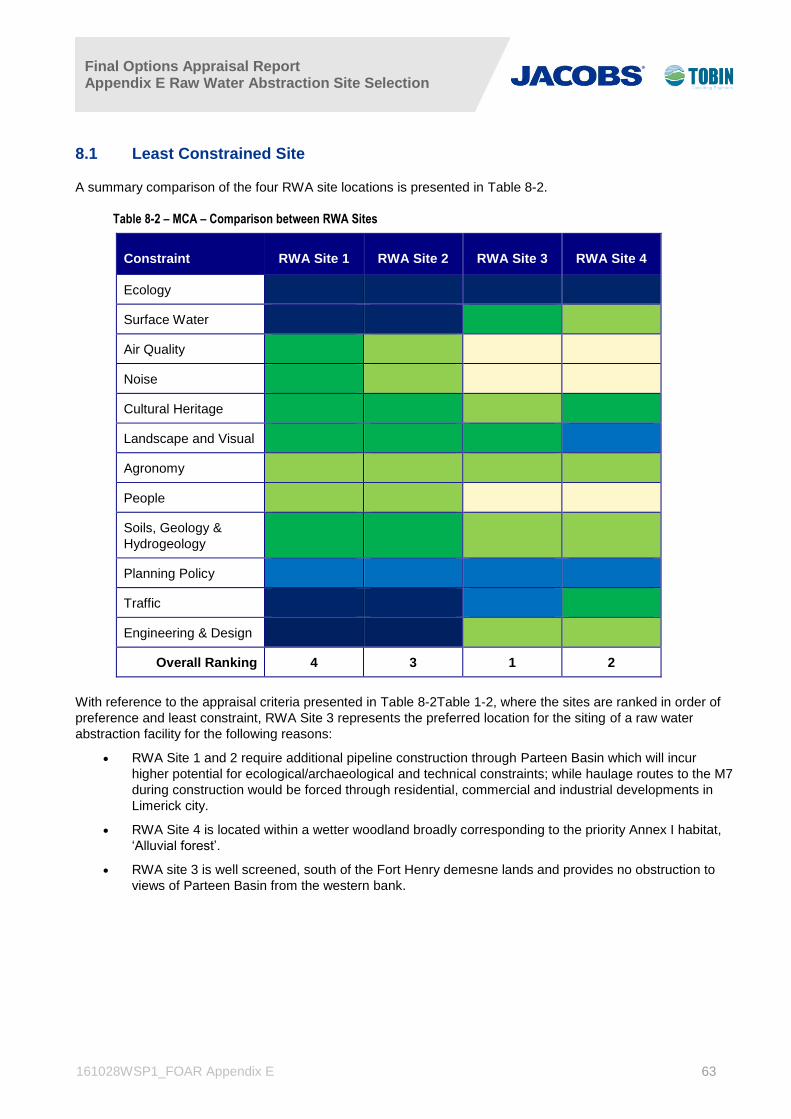
Final Options Appraisal Report Appendix E Raw Water Abstraction Site Selection
161028WSP1_FOAR Appendix E 63
8.1 Least Constrained Site
A summary comparison of the four RWA site locations is presented in Table 8-2.
Table 8-2 – MCA – Comparison between RWA Sites
Constraint RWA Site 1 RWA Site 2 RWA Site 3 RWA Site 4
Ecology
Surface Water
Air Quality
Noise
Cultural Heritage
Landscape and Visual
Agronomy
People
Soils, Geology &
Hydrogeology
Planning Policy
Traffic
Engineering & Design
Overall Ranking 4 3 1 2
With reference to the appraisal criteria presented in Table 8-2Table 1-2, where the sites are ranked in order of
preference and least constraint, RWA Site 3 represents the preferred location for the siting of a raw water
abstraction facility for the following reasons:
RWA Site 1 and 2 require additional pipeline construction through Parteen Basin which will incur
higher potential for ecological/archaeological and technical constraints; while haulage routes to the M7
during construction would be forced through residential, commercial and industrial developments in
Limerick city.
RWA Site 4 is located within a wetter woodland broadly corresponding to the priority Annex I habitat,
‘Alluvial forest’.
RWA site 3 is well screened, south of the Fort Henry demesne lands and provides no obstruction to
views of Parteen Basin from the western bank.


