China Satellite Navigation OfficeION GNSS+ 2016
September 12-16, 2106, Portland, Oregon, USA
Dr. Jun Shen ([email protected])Deputy Director, International Cooperation Center
China Satellite Navigation Office
The 56th Meeting of the Civil GPS Service Interface Committee
at the ION GNSS+ 2016 Conference
September 12-13, 2016
Portland, Oregon, USA

China Satellite Navigation OfficeION GNSS+ 2016
September 12-16, 2106, Portland, Oregon, USA
01
DevelopmentPlan
03
Near-term Plan
02
LatestProgress

China Satellite Navigation OfficeION GNSS+ 2016
September 12-16, 2106, Portland, Oregon, USA
01
DevelopmentPlan
03
Recent Plan
02
LatestProgress
Development Objectives
Basic Principles
Development Steps
System Components
Fundamental Policies
China Satellite Navigation OfficeION GNSS+ 2016
September 12-16, 2106, Portland, Oregon, USA
BDS is committed:
To provide continuous, stable and reliable positioning, navigation and timing services to global users;
To meet the requirements derived from national security, economic and social development sectors, to accelerate IT applications and the transformation of economic development methods, and to improve both economic and social benefits;
To serve the world and benefit the mankind through joint efforts with other navigation satellite systems across the globe.

China Satellite Navigation OfficeION GNSS+ 2016
September 12-16, 2106, Portland, Oregon, USA
BasicPrinciples
Openness
BDS will offer open services free of charge for global users.
Independency
Develop and operate the BeiDou system independently.
Compatibility
BDS is devoted to pursue compatibility and interoperability with other navigation satellite systems, and enable users to obtain better services.
Gradualness
The establishment of BDS follows a stepwise manner in the light of Chinese actual technical and economic conditions.

China Satellite Navigation OfficeION GNSS+ 2016
September 12-16, 2106, Portland, Oregon, USA
第一步 第二步 第三步
The 1st step:
1994~2000, provide regional active services
The 2nd step: 2004~2012, provide regional passive services
The 3rd step: 2013~2020, provide global passive services
• BDS has been developing
• in line with the three-step roadmap
• the thinking of from regional to global, and from active to passive
• forms a development path as world-oriented, region-highlighted, with its unique features.

China Satellite Navigation OfficeION GNSS+ 2016
September 12-16, 2106, Portland, Oregon, USA
space
segment
ground segment
user segment
• 5 GEO satellites• 3 IGSO satellites• 27 MEO satellites
• Master Control Stations (MCS)• Uplink Stations (US)• Monitoring Stations (MS)
• BDS terminals• Terminals compatible with other
GNSS
BDS is comprised of
three major
components: space
segment, ground
control segment and
user segment.
BDS is able to provide
four types of services,
namely, open,
authorized, wide area
differential and short
message services.
The positioning
accuracy is better than
10 meters, the timing
accuracy is better than
20 nanoseconds, and
the velocity accuracy is
better than 0.2 meters
per second.

China Satellite Navigation OfficeION GNSS+ 2016
September 12-16, 2106, Portland, Oregon, USA
• Provide open services free of charge for users.
• Maintain and enhance the system, and improve service performance continuously, and offer services with higher quality.
• Release open service performance specifications and related system documents on schedule, bring the function of government and market to full play, promote innovation, popularization and internationalization of BDS/GNSS applications, and lay foundation for the national strategic emerging industries.
• Adhere to the concept of development and win-win cooperation, realize compatibility and interoperability between BDS and other GNSS, give the system efficiency into full play and increase users’ benefits.

China Satellite Navigation OfficeION GNSS+ 2016
September 12-16, 2106, Portland, Oregon, USA
01
DevelopmentPlan
03
Near-term Plan
02
LatestProgress
System Construction
Application Promotion
International Cooperation
China Satellite Navigation OfficeION GNSS+ 2016
September 12-16, 2106, Portland, Oregon, USA
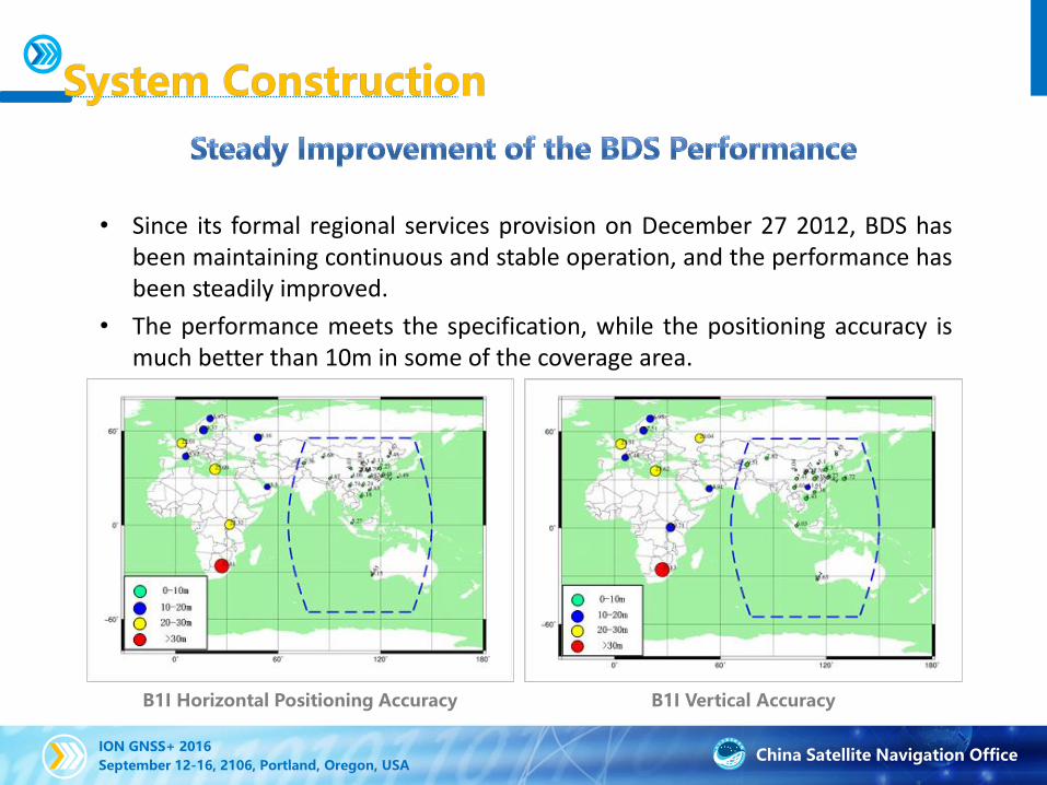
• Since its formal regional services provision on December 27 2012, BDS hasbeen maintaining continuous and stable operation, and the performance hasbeen steadily improved.
• The performance meets the specification, while the positioning accuracy ismuch better than 10m in some of the coverage area.
B1I Horizontal Positioning Accuracy B1I Vertical Accuracy

China Satellite Navigation OfficeION GNSS+ 2016
September 12-16, 2106, Portland, Oregon, USA
• Since 2015, five new-generation BDS satellites and two in-orbit spare satellites have been successfully launched.
• The advanced signal structure, inter-satellite link, on-board clocks with higher accuracy and other key system components and technical issues have been verified.
• After the intra-system technical state is coordinated, five new-generation BDS satellites will provide services in a timely manner.
• The new satellites will also further enhance the solidity of the BDS constellation, improve the ability of system services, and establish a solid foundation for the future global services.

China Satellite Navigation OfficeION GNSS+ 2016
September 12-16, 2106, Portland, Oregon, USA
• After two IGSO satellites were successfully launched recently, in the BDS coverage area,
• the average PDOP(95 percent)decreases from 3.07 to 2.84
• the average minimum number of visible satellites increases from 7.0 to 8.3

China Satellite Navigation OfficeION GNSS+ 2016
September 12-16, 2106, Portland, Oregon, USA
BDS - Design & Development Plan
BDS Augmentation System Architecture

China Satellite Navigation OfficeION GNSS+ 2016
September 12-16, 2106, Portland, Oregon, USA
• Accelerate the construction of the National BeiDou Ground-Based Augmentation System (BDGBAS), and create a high-accuracy location platform with special application services.
• A nation-wide reference station network has been built, and the construction of the basic system has been preliminarily completed.
• The system performance is being tested,including meter and decimeter level for wide-area real-time services, centimeter level for the areas within Beijing, millimeter level for post-processing services.
BDS Ground-Based Augmentation System
China Satellite Navigation OfficeION GNSS+ 2016
September 12-16, 2106, Portland, Oregon, USA
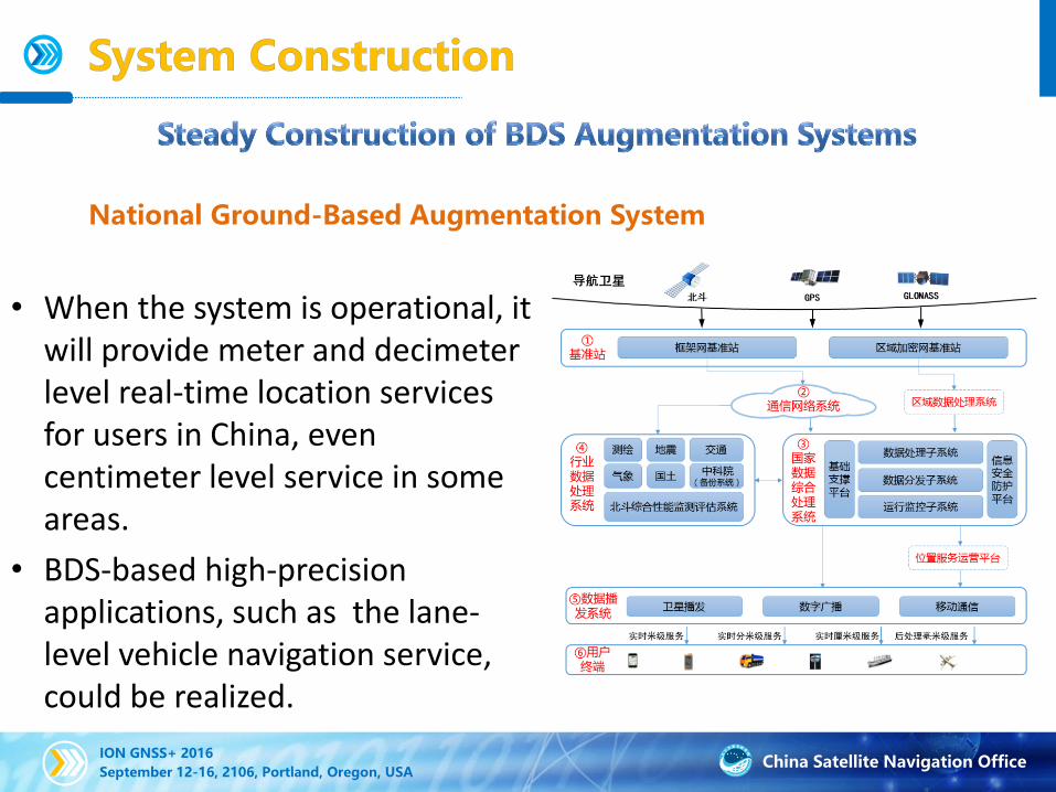
National Ground-Based Augmentation System
• When the system is operational, it will provide meter and decimeter level real-time location services for users in China, even centimeter level service in some areas.
• BDS-based high-precision applications, such as the lane-level vehicle navigation service, could be realized.

China Satellite Navigation OfficeION GNSS+ 2016
September 12-16, 2106, Portland, Oregon, USA
Data Processing System Data Broadcasting System
Mobile Satellite Digital
Radio
User Terminals
BeiDou Reference Stations
Raw data from Satellite
Observation
High-precision
Data Product
BDGBAS
National Ground-Based Augmentation System – System Architecture

China Satellite Navigation OfficeION GNSS+ 2016
September 12-16, 2106, Portland, Oregon, USA
• 150 national wide-area reference
stations (RSs), 1200 regional RSs
• National BeiDou Data Integrated
Processing System, Data Backup System,
6 kinds of Industrial Data Processing
Systems
• 3 broadcasting paths: Mobile
Communication, Satellite Broadcasting,
Digital Radio
• 4 kinds of high-precision positioning
services: wide-area real-time meter level
and decimeter level, regional real-time
centimeter level, post-processing
millimeter level
BDGBAS – System Components
Wide Area RSs Regional RSs
①Reference
Stations
③National
Data
Processin
g System
Data Processing
Subsystem
Data Distribution
SubsystemOperating Monitoring
Subsystem
⑤Data
Broadcastin
g
System
⑥User
Terminals
④Industrial
Data
Processin
g System
Post mm serviceRT cm serviceRT dm serviceRT m level service
Surve
y
Weath
er
Transpo
r-tation
Seismologica
l
Lan
d
Satellite
BroadcastingDigital Radio
Mobile
Communication
②Communication
Network System
BDS Performance Monitor
& Evaluation System
CAS
Regional Data
Processing System
Positioning
Service
Operating
Platform
Infor-
mation
Security
System
Basic
support
platform
BDS
Navigation
SatelliteGPS GLONASS

China Satellite Navigation OfficeION GNSS+ 2016
September 12-16, 2106, Portland, Oregon, USA
Satellite System BDS BDS BDS BDS/GP/GLONASS BDS/GPS
Augmentation
Mode
Wide-area real-
time single-
frequency pseudo
range mode
Wide-area real-
time single-
frequency carrier
phase mode
Wide-area real-
time dual-
frequency carrier
phase mode
Local-area real-time
RTK
Post-processing
millimeter mode
Horizontal
Position
Accuracy
Meter level
(95%)
Meter level
(95%)
Decimeter lever
(95%)
Centimeter level
(RMS)
Millimeter level
(RMS)
Vertical
Position
Accuracy
Meter level (95%) Meter level (95%) Decimeter lever
(95%)
Centimeter level
(RMS)
Millimeter level
(RMS)
Broadcasting
DataData of Precise orbit, Clock bias, Ionosphere
Synthetic correction
dataPost processing
Broadcasting
ModeSatellite,Digital Radio, Mobile Communication
Mobile
CommunicationInternet
Main Specifications of BDGBAS

China Satellite Navigation OfficeION GNSS+ 2016
September 12-16, 2106, Portland, Oregon, USA
Satellite System BDS BDS BDS BDS/GP/GLONASS BDS/GPS
User Number Unlimited 106 Unlimited
Service Area Depending on the coverage area of the chosen broadcasting mode
Service Target People,Vehicles,ObjectsApplications of
Centimeter level
Deformation
monitoring
Application
Terminal
Smart phone, wearable Devices, navigation instruments,
tablet computers, and so on
Hand-held
terminals, and so
on
Static or fixed
sensors, and so on
Main Services of BDGBAS
Implement one system to realize 4 categories and 5 kinds of high-precision positioning services for the first time.

China Satellite Navigation OfficeION GNSS+ 2016
September 12-16, 2106, Portland, Oregon, USA
• Support the development
of BeiDou high-precision
chips, smartphones,
navigators, smartphone +
BeiDou mate/“Magic
Box”, and other user
terminals.
• Relative tests have been
conducted and
application
demonstrations are
verified.
Service Platform
BDS/GPS
BDS Data
Center
Mobile
Communication
RSs
MSTP
BeiDou Magic
Box/BANLV
Display and
Control Console
BDS High-
precision
smartphone
BDS Navigator
20

China Satellite Navigation OfficeION GNSS+ 2016
September 12-16, 2106, Portland, Oregon, USA
地面监测站网络
观测数据(每1秒传输一次)
GEO
主控站
地面注入站
告警门限
增强健康信息卫星部分增强信息格网电离层增强信息
MEO和IGSO
基本导航电文
增强健康信息卫星部分增强信息格网电离层增强信息
BDS will comply with the international civil aviation standards, carry out the design, validation and construction of BeiDou Satellite-Based Augmentation System (BDSBAS), and provide CAT-I services to civil aviation users in China and surrounding areas.
At present, BDS is actively participating in the design and international coordination activities for the next-generation Double Frequency Multiple Constellation (DFMC) SBAS Standards.
Satellite-Based Augmentation System
China Satellite Navigation OfficeION GNSS+ 2016
September 12-16, 2106, Portland, Oregon, USA
BDSBAS - Design & Development Plan
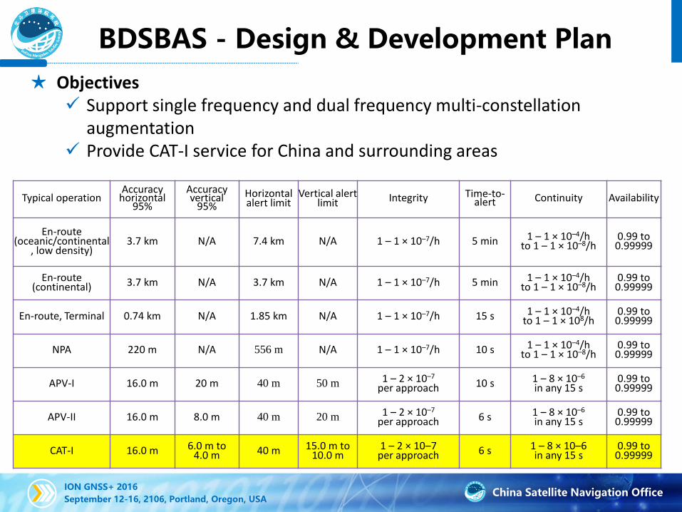
★ Objectives Support single frequency and dual frequency multi-constellation
augmentation Provide CAT-I service for China and surrounding areas
Typical operationAccuracy
horizontal95%
Accuracyvertical
95%Horizontal alert limit
Vertical alert limit Integrity Time-to-
alert Continuity Availability
En-route (oceanic/continental
, low density)3.7 km N/A 7.4 km N/A 1 – 1 × 10⁻⁷/h 5 min 1 – 1 × 10⁻⁴/h
to 1 – 1 × 10⁻⁸/h0.99 to0.99999
En-route (continental) 3.7 km N/A 3.7 km N/A 1 – 1 × 10⁻⁷/h 5 min 1 – 1 × 10⁻⁴/h
to 1 – 1 × 10⁻⁸/h0.99 to0.99999
En-route, Terminal 0.74 km N/A 1.85 km N/A 1 – 1 × 10⁻⁷/h 15 s 1 – 1 × 10⁻⁴/h to 1 – 1 × 10⁸/h
0.99 to0.99999
NPA 220 m N/A 556 m N/A 1 – 1 × 10⁻⁷/h 10 s 1 – 1 × 10⁻⁴/hto 1 – 1 × 10⁻⁸/h
0.99 to0.99999
APV-I 16.0 m 20 m 40 m 50 m 1 – 2 × 10⁻⁷
per approach 10 s 1 – 8 × 10⁻⁶
in any 15 s0.99 to0.99999
APV-II 16.0 m 8.0 m 40 m 20 m 1 – 2 × 10⁻⁷
per approach 6 s 1 – 8 × 10⁻⁶
in any 15 s0.99 to0.99999
CAT-I 16.0 m 6.0 m to 4.0 m 40 m 15.0 m to
10.0 m1 – 2 × 10⁻⁷
per approach 6 s 1 – 8 × 10⁻⁶in any 15 s
0.99 to0.99999
China Satellite Navigation OfficeION GNSS+ 2016
September 12-16, 2106, Portland, Oregon, USA
BDSBAS - Design & Development Plan
• System Components
Constellation/Space Segment: 3 GEO Satellites (80°E, 110°E, 140°E).
Augmentation signals: BDS B1C and B2a, interoperable with international SBAS standards.
Augmentation messages: ephemeris correction, ionospheric delay correction, and corresponding UDRE and GIVE, compatible with international SBAS standards.
Monitoring Station Network: 30 stations in China, 20 stations in surrounding areas.
Master Control Station: processing dual frequency signals from BDS, GPS, GLONASS and GALILEO; generate augmentation messages.

China Satellite Navigation OfficeION GNSS+ 2016
September 12-16, 2106, Portland, Oregon, USA
BDSBAS - Design & Development Plan
• Development Plan
2014: Evaluation of BDS augmentation performance.
2014-2015: Participate in dual frequency multi-constellation SBAS standard establishment through ICAO, IWG etc.
2018: Launch the first BDSBAS GEO satellite.
2020: Finish the launch of 3 GEOs. Start to provide dual frequency multi-constellation SBAS service for China and surrounding areas users.
2025: Provide augmentation services for users in larger areas through international cooperation.

China Satellite Navigation OfficeION GNSS+ 2016
September 12-16, 2106, Portland, Oregon, USA25
地图信息
遥感信息 影像信息
气象信息 交通信息
信息采集网络 蜂窝移
动通信 数字
广播个人
通信
卫星通信
通信网络
互联网服务提供商
(ISP)
PNT体系 用户
PNT基准
时空信息
信息资源
PNT基准
时间同步、定位、
信息资源
用户信息
用户
信息
增值
服务
国家信息基础设施
• Satellite navigation system has some blind areas in deep spaces, indoor spaces and underwater spaces. In order to compensate it and to meet the needs of economic and social development, the cornerstone of the BeiDou system is being reinforced.
• At the same time, national PNT system is being demonstrated, and some related technical research is being carried out.
.

China Satellite Navigation OfficeION GNSS+ 2016
September 12-16, 2106, Portland, Oregon, USA
BDS/GNSS navigation chip/module, surpass 24 million pieces
high-precision surveying boards, approximately 120, 000 sets
navigation antenna, 4 million pieces
high-precision antenna, surpass 500,000 pieces
satellite navigation IP core used in mobile communication, approximately 18 million
• In 2015, BDS fundamental products have been upgraded in terms of self-controlled intellectual properties, quality and quantity.
• BDS chips have entered a new era of 40-nanometer, and achieved a jumped upgrade from basic products to high-end industry.

China Satellite Navigation OfficeION GNSS+ 2016
September 12-16, 2106, Portland, Oregon, USA
Demonstrations in the Transportation Industry
• A total of 3 million sets of BDS/GNSS compatible terminals have beeninstalled in the coach, tourism charter, dangerous goods vehicles andother key fields.

China Satellite Navigation OfficeION GNSS+ 2016
September 12-16, 2106, Portland, Oregon, USA
Demonstrations in the Yangtze River Delta Region
• Some BDS application demonstrations related to the Smart City, suchas vehicle monitoring services, public location services and highaccuracy positioning service etc., have been conducted, and 80,000sets of BDS terminals have been deployed.

China Satellite Navigation OfficeION GNSS+ 2016
September 12-16, 2106, Portland, Oregon, USA
珠三角
湘
苏陕
鄂
贵
北京
17个示范区域
上海
深圳
合肥
哈尔滨
兵团八师
成都
绵阳西安
漳州
信阳
潍坊
• 11 industrial demonstrations, such as maritime transportation, meteorology, fisheries, public safety, disaster relief and civil affairs , as well as 17 regional demonstration projects, including those in Pearl River Delta, Beijing, Shaanxi, Hunan, Guizhou, Hubei and Jiangsu, are being carried out .

China Satellite Navigation OfficeION GNSS+ 2016
September 12-16, 2106, Portland, Oregon, USA

China Satellite Navigation OfficeION GNSS+ 2016
September 12-16, 2106, Portland, Oregon, USA
• With the development of some key technologies, such as chipminiaturization, low power, low cost, and RF baseband integration etc., aswell as extensive integration of satellite navigation IP core and mobilecommunications, BeiDou will be fully applied to the mass market and servethe public.

China Satellite Navigation OfficeION GNSS+ 2016
September 12-16, 2106, Portland, Oregon, USA
• Receive BDS B1, GPS L1and GLONASS L1 data
• BDS and GPS single-mode positioning, BDS+GPS dual-mode joint
positioning
• Integrated Bluetooth, WiFi, RF (Radio Frequency) and BB
(baseband) frequency modulation
• Enable high-precision positioning, A-GNSS, anti-narrowband
interference
• Low cost, low SWaP (Size, Weight and Power). the chip size is
only 4.8mm×4.8mm
• Allow ease of use for smartphones, tablet computers, wearable
devices, hand-held terminals, and on-board vehicle terminals
• Shipments in 2015 are over 18 million pieces
LX1101multi-function chip
32

China Satellite Navigation OfficeION GNSS+ 2016
September 12-16, 2106, Portland, Oregon, USA
• Allow BeiDou high-precision positioning
service embedded in the existing
smartphones.
• Receive BeiDou high-precision data
through 3G/4G mobile communication
channels and derive BeiDou high-
precision positioning information.
• Communicate with Smartphone via
Bluetooth.
BeiDou “Magic Box”
33
China Satellite Navigation OfficeION GNSS+ 2016
September 12-16, 2106, Portland, Oregon, USA
• A compact,high-precision GNSS data collection
device.
• It integrates multi-GNSS high-precision card, 3.75G
mobile communication module, WIFI, Bluetooth, etc.
• Coupled with an Android phone or a Windows tablet,
it can work with a GNSS argumentation system to
provide CM-level high-precision services.
34

China Satellite Navigation OfficeION GNSS+ 2016
September 12-16, 2106, Portland, Oregon, USA35
• Built-in GNSS positioning module, supporting BDS/GPS/ GLONASS systems (including BDS-only mode).
• Uses quad-core 1.2GHz snapdragon chip, with a Cortex-A53 architecture.
• Supports all mobile communication standards, including FDD-LTE/TDD-LTE/TD-SCDMA/WCDMA/ CDMA2000/ GSM.
• Rugged structure.• Android 5.1 operating system.• 5.3” ultra-sensitive screen.• Supports RTCM-IN, can be connected using NTRIP
to work with a GNSS argumentation system to provide high-precision services.

China Satellite Navigation OfficeION GNSS+ 2016
September 12-16, 2106, Portland, Oregon, USA
• The government attaches great importance to and promote thedevelopment of satellite navigation industry actively.
• “National medium and long term development program on satellitenavigation industry” and “National medium and long term developmentprogram on civil space fundamental facility” have been released, whichmakes the general dispositions in the long term development ofsatellite navigation industry at the national level.

China Satellite Navigation OfficeION GNSS+ 2016
September 12-16, 2106, Portland, Oregon, USA
• A government white paper, entitled as “China’s BeiDou Navigation Satellite System”, was released on June 16, 2016.
• The white paper describes the Chinese government’s policy, roadmap, major achievements, etc. on the development process of BeiDou Navigation Satellite System.
• The white paper contains five major parts:• Goals and Principles of Development• BDS Development• Reliable and Safe Satellite Navigation
Services• BDS Application and Industrial
Development• International Cooperation and
Exchanges

China Satellite Navigation OfficeION GNSS+ 2016
September 12-16, 2106, Portland, Oregon, USA
国家北斗卫星导航标准体系(1.0)
• “BeiDou Navigation Satellite Standard System (version 1.0)” and 17BeiDou standards have been released, which promote theconstruction of BeiDou navigation satellite standard system.

China Satellite Navigation OfficeION GNSS+ 2016
September 12-16, 2106, Portland, Oregon, USA
• “Legal Rules for BeiDou Navigation” have been listed in the legislation work plan of the state department in 2016, and it will be the first administrative law and regulation in the field of satellite navigation. It will protect reliable BDS services and improve the level of BDS management.

China Satellite Navigation OfficeION GNSS+ 2016
September 12-16, 2106, Portland, Oregon, USA
Applicationterminals
Fundamentalproducts
services
The output value of satellite navigation
In 2015
BDS contribution
counts
……

China Satellite Navigation OfficeION GNSS+ 2016
September 12-16, 2106, Portland, Oregon, USA
• Coordinate with other navigation satellite system providers in the sector of compatibility and interoperability, and provide users with high quality services.

China Satellite Navigation OfficeION GNSS+ 2016
September 12-16, 2106, Portland, Oregon, USA
• The cooperation mechanism between BDS and GPS has been set up.
• Two bilateral meetings of China-U.S. civil GNSS cooperation were held, and the Joint Statement between these two systems was released.
• Cooperation has been carried out in the field of compatibility and interoperability, augmentation system and civil aviation application, civil service, monitoring and evaluation.

China Satellite Navigation OfficeION GNSS+ 2016
September 12-16, 2106, Portland, Oregon, USA
The Chinese-Russian Committee on Important Projects of Strategic Cooperation in the field of Satellite Navigation has been founded within the China-Russia Prime Ministers’ Regular Meeting Framework.
The memorandum of understanding on satellite navigation cooperation has been signed.
Working groups have been set up. Station building exploring has been finished.
The Joint Statement on GLONASS/BeiDou systems Compatibility and Interoperability and Navigation Technology Application Cooperation has been released.
The first seven cooperation projects have been brought out.

China Satellite Navigation OfficeION GNSS+ 2016
September 12-16, 2106, Portland, Oregon, USA
• The frequency coordination towards navigation frequency channels between BeiDou and Galileo has been completed,
• The cooperation mechanism between these systems are under discussion, especially in the field of compatibility and interoperability.
China Satellite Navigation OfficeION GNSS+ 2016
September 12-16, 2106, Portland, Oregon, USA
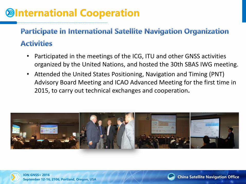
• Participated in the meetings of the ICG, ITU and other GNSS activities organized by the United Nations, and hosted the 30th SBAS IWG meeting.
• Attended the United States Positioning, Navigation and Timing (PNT) Advisory Board Meeting and ICAO Advanced Meeting for the first time in 2015, to carry out technical exchanges and cooperation.

China Satellite Navigation OfficeION GNSS+ 2016
September 12-16, 2106, Portland, Oregon, USA
• Encourage academic exchanges• Host the China Satellite Navigation
Conference, the largest GNSS conference in the world
• Attend other international academic conferences in the field of satellite navigation
• Carry out the education and training on global satellite navigation, especially in the developing countries.

China Satellite Navigation OfficeION GNSS+ 2016
September 12-16, 2106, Portland, Oregon, USA
Pakistan National Positioning Service Network Project Phase I
Pakistan National Positioning Service Network Project (Phase I)
48
China Satellite Navigation OfficeION GNSS+ 2016
September 12-16, 2106, Portland, Oregon, USA
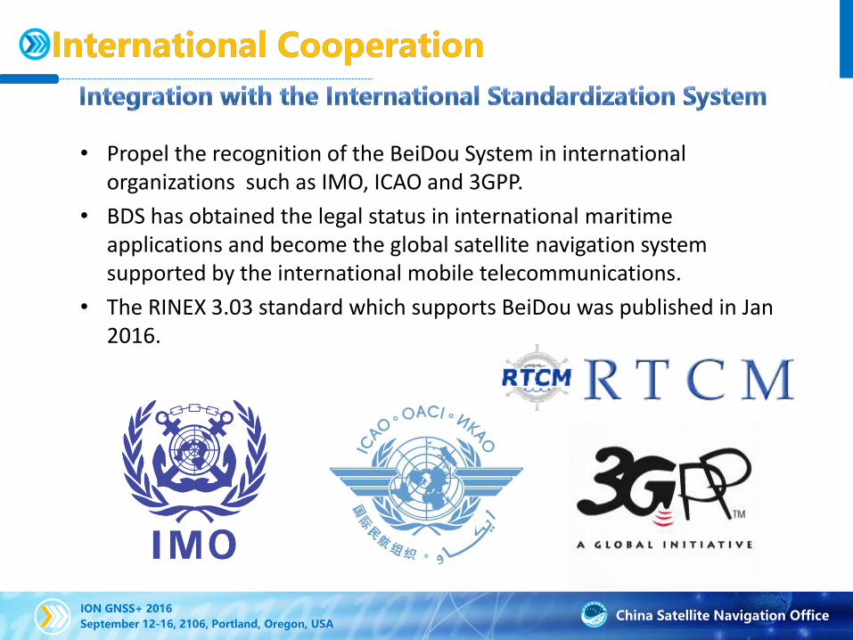
• Propel the recognition of the BeiDou System in international organizations such as IMO, ICAO and 3GPP.
• BDS has obtained the legal status in international maritime applications and become the global satellite navigation system supported by the international mobile telecommunications.
• The RINEX 3.03 standard which supports BeiDou was published in Jan 2016.

China Satellite Navigation OfficeION GNSS+ 2016
September 12-16, 2106, Portland, Oregon, USA
01
DevelopmentPlan
03
Near-term Plan
02
LatestProgress
System Construction
Application Promotion
International Cooperation
China Satellite Navigation OfficeION GNSS+ 2016
September 12-16, 2106, Portland, Oregon, USA
Keep improving the continuous stability and service accuracyof the BeiDou System, and ensuring its regional serviceperformance stable and enhancing.
The BDS performance in Asia-Pacific area will becontinuously improved. In the future, the status of the new-generation satellites will be solidified which would promotethe construction of the global constellation. BDS will provideservices for Silk Road Economic Belt and 21st-CenturyMaritime Silk Road countries by 2018. And it will possess theglobal services capability and construct the high-class globalnavigation system by 2020.
China Satellite Navigation OfficeION GNSS+ 2016
September 12-16, 2106, Portland, Oregon, USA
Complete the integration and the test of BeiDou Ground-BasedAugmentation System by mid-2016, with meter/decimeter-levelpositioning accuracy available to major regions nationwide,centimeter level to densified regions, and millimeter level correctiondata for post-processing services. Complete the construction ofdense reference stations for the nationwide frame network by 2018.Start launching GEO satellites of BDSBAS in 2018. Finish theconstruction of BDSBAS services covering China and surroundingregions in 2020.
Promote and complete the construction of the nationalcomprehensive PNT system with a united benchmark, no-gapcoverage, security and effectiveness by 2030. Remarkably advancethe national time and space services, meet the requirements derivedfrom national economic and security sectors, and provide high-quality services to global users.

China Satellite Navigation OfficeION GNSS+ 2016
September 12-16, 2106, Portland, Oregon, USA
Carry out all-round R&D and industrialization of new generation BDS/GNSS fundamental products, improve the core strength (e.g. service performance, power consumption, physical dimensions, cost) so as to promote the mass market applications of hundred-million units.
Bring GNSS in the integration procedure between industrialization and IT applications, integrate GNSS with the national policies (the Silk Road Economic Belt and 21st-Century Maritime Silk Road, Beijing-Tianjin-Hebei Integration, Yangtze River Economic Belt), push forward applications.
Accelerate the legislation process of “Legal Rules of BeiDou Navigation”,bring BeiDou into the national information security system, establish a legal environment for BeiDou construction, circulation and application promotion.
Construct ecologic system for BeiDou applications and services; promote the innovation of BeiDou applications according to “Four Combination” with the network, the data, the terminal and the capital.

China Satellite Navigation OfficeION GNSS+ 2016
September 12-16, 2106, Portland, Oregon, USA
Continue to promote cooperation and exchanges between BeiDou and other GNSS providers, enhance the cooperation in compatibility and interoperability, monitoring and evaluation, SBAS and aviation applications, etc.
Continue to carry out international coordination in international organizations, such as ICG, ITU, ICAO, IMO, promote the BDS internationalization, and to undertake the international responsibility of BDS.
Use the Silk Road Economic Belt and 21st-Century Maritime Silk Road as a fulcrum, promote the BDS internationalizationprocess, and serve the areas along it.
China Satellite Navigation OfficeION GNSS+ 2016
September 12-16, 2106, Portland, Oregon, USA
• Perception is the foundation of intelligence, and the intelligent demand leads the development of perception.
• Time and space information are the basic needs that people born with and lead our perception all the time and make our life more intelligent.
• Satellite navigation system enables a revolutionary change of the perception of time and space information, and accelerates the arrival of the intelligent era.
• BDS will play a major role in terms of promoting the development of the intelligent time.
• BeiDou appreciates your attention and support.
China Satellite Navigation OfficeION GNSS+ 2016
September 12-16, 2106, Portland, Oregon, USA
THANK YOU!
Dr. Jun Shen ([email protected] )
Deputy Director, International Cooperation CenterChina Satellite Navigation Office
http://en.beidou.gov.cn


