
DOE-EMCHAR-012 Rev. 1
Geotechnical Report for Data Gap Characterization at the Proposed Outfall 200
Mercury Treatment Facility Sites
Prepared by: CTI and Associates for
Strata-G, LLC 2027 Castaic Lane
Knoxville, TN 37932 Telephone: (865) 934.3400 Facsimile: (865) 934.3439
Prepared for: U.S. Department of Energy, Oak Ridge
P.O. Box 2001 Oak Ridge, TN 37831
January 4, 2017
Geotechnical Report
Proposed Mercury Treatment Facility Site (Y-12 Outfall 200 Facility) Final Report, January 2017
DOE-EMCHAR-012, Rev 1 Page 1 of 16
TABLE OF CONTENTS
1.0 Introduction ....................................................................................................................................... 2
1.1 Background ................................................................................................................................... 2
1.2 Site Description ............................................................................................................................. 4
1.3 Scope and Purpose ........................................................................................................................ 4
2.0 Characterization Programs ................................................................................................................ 6
2.1 Geotechnical Field Investigation .................................................................................................. 6
2.2 Geophysical Logging Program ..................................................................................................... 6
3.0 General Subsurface Conditions ......................................................................................................... 9
3.1 Encountered Soil and Rock Conditions ........................................................................................ 9
3.2 Encountered Voids ........................................................................................................................ 9
3.3 Other Observations ..................................................................................................................... 12
3.4 Headcut Erodibility Index ........................................................................................................... 13
4.0 References ....................................................................................................................................... 16
Tables:
Table 1. Boreholes Selected for Geophysical Logging
Table 2. Depth to Top of Bedrock/Auger Refusal
Table 3. Void Intervals in Borings
Table 4. Calculation of Headcut Erodibility Index, Kh
Figures:
Figure 1. General Location of the Proposed Outfall 200 Mercury Treatment Facility.
Figure 2. Generalized Geology Near Project Site (from USGS)
APPENDICES
APPENDIX A – Drilling Logs
APPENDIX B – Geophysical Logging Report
APPENDIX C – Boring Location Plan
APPENDIX D – General Notes for Soil/Rock Classification
Geotechnical Report
Proposed Mercury Treatment Facility Site (Y-12 Outfall 200 Facility) Final Report, January 2017
DOE-EMCHAR-012, Rev 1 Page 2 of 16
1.0 INTRODUCTION
1.1 BACKGROUND
The U.S. Department of Energy (DOE) Oak Ridge Reservation (ORR) is located within and adjacent to
the corporate limits of the city of Oak Ridge, Tennessee. The ORR hosts three major industrial research
and production facilities originally constructed as part of the World War II-era Manhattan Project: the
East Tennessee Technology Park (formerly the K-25 site); the Oak Ridge National Laboratory (ORNL);
and the Y-12 National Security Complex (Y-12). The DOE, Oak Ridge Environmental Management
office (OREM) proposes to construct a surface water treatment facility, Outfall 200 Mercury Treatment
Facility, within the footprint of Y-12. The area proposed for construction of the Outfall 200 Mercury
Treatment Facility is located in the south-central to south-eastern portion of the Y-12 site, as shown in
Figure 1.
Historical missions of Y-12 have resulted in the release of mercury and other contaminants to the
environment and contamination has been identified in soil, sediment, surface water, groundwater,
buildings, drains, and sumps. Mercury continues to be released into the Upper East Fork Poplar Creek
(UEFPC) from point (discrete) and non-point (diffuse) sources within Y-12. Mercury enters UEFPC from
direct erosion of contaminated soil, migration of dissolved mercury through storm drains and several
outfalls, and through shallow groundwater. The West End Mercury Area consists of former mercury use
buildings located in the west end of the Y-12 main plant area, including mercury contaminated soils and
storm sewers in the immediate vicinity. Residual mercury in the seventy year-old deteriorating storm
drain infrastructure, infiltrating groundwater, and sediment-bound mercury are remobilized and
transported through the storm drain network through Outfall 200 into the UEFPC. UEFPC and the
Maynardville Limestone provide conduits for contaminant migration. Because of the toxicity and
mobility of mercury contamination, several mercury source areas were identified as containing principal
threat wastes per EPA guidance and were the focus of the Phase I Record of Decision (ROD) (DOE
2002).
Currently, the mercury contamination is considered the greatest environmental risk on the DOE ORR (it
should be noted that the Phase II ROD for UEFPC [DOE 2006] included additional contaminants of
concern such as cadmium, uranium, polychlorinated biphenyl compounds [PCBs], several radionuclides,
and volatile organic compounds [VOCs]). The primary pathway of concern is surface water because the
UEFPC flows directly from the Y-12 complex through the city of Oak Ridge. During 1998–2000, DOE
prepared Comprehensive Environmental Response, Compensation, and Liability Act of 1980 (CERCLA)
Remedial Investigation/Feasibility Study documents for the UEFPC Characterization Area focused on
potential source units (i.e. areas of soil contamination and groundwater plumes) that potentially contribute
to the transport of contaminants within and from the Characterization Area. In 2002, the UEFPC
Characterization Area Phase I ROD (DOE 2002) was signed, outlining future cleanup actions.
Discharges from the West End Mercury Area are primary point source contributors to mercury flux in
UEFPC. Outfall 200 is the integration point for storm sewer effluent entering UEFPC; and under dry
weather (base) flow conditions is consistently the largest single source of mercury to the creek
(URS/CH2M Oak Ridge LLC [UCOR] 2013).
Over the past two decades, DOE has implemented a series of projects that have reduced the
concentrations of mercury measured at the site boundary at Station 17, the Y-12 National Pollutant
Discharge Elimination System (NPDES) permit compliance point. While mercury concentrations in water
at Station 17 have declined, the concentrations continue to exceed the surface water concentration goal
specified in the UEFPC Characterization Area Phase I ROD. Until the West End Mercury Area discharge
is collected and treated, mercury will continue to impact the sediment in UEFPC.

Geotechnical Report
Proposed Mercury Treatment Facility Site (Y-12 Outfall 200 Facility) Final Report, January 2017
DOE-EMCHAR-012, Rev 1 Page 3 of 16
Figure 1. General location of the proposed Outfall 200 Mercury Treatment Facility.

Geotechnical Report
Proposed Mercury Treatment Facility Site (Y-12 Outfall 200 Facility) Final Report, January 2017
DOE-EMCHAR-012, Rev 1 Page 4 of 16
Several significant measures are being implemented to address mercury flux in UEFPC. The National
Nuclear Security Administration submitted plans to relocate and/or reduce raw water addition to UEFPC
based on previous studies that showed a reduction in flow augmentation can achieve a corresponding
reduction in mercury flux in UEFPC (DOE 2009). Additionally, DOE’s OREM has proposed and
completed the conceptual design for a surface water treatment facility, the Outfall 200 Mercury Treatment
Facility which will significantly reduce mercury loading to UEFPC.
1.2 SITE DESCRIPTION
The project site is located in the south-central portion of Y-12. Specifically, the project consists of two
separate areas: the headworks area and the Mercury Treatment Facility area. The headworks area is
located south of the Building 9204-1 and treatment facility area is located in the southeastern quadrant of
the intersection of B Road and Second Street (former Building 9720-8 site). The headworks area will
include a weir intake structure, grit removal chamber, storage tanks, and pumping station located adjacent
to Outfall 200. The treatment facility will include an equalization tank, chemical reaction tanks, inclined
plate clarifiers, clarifier effluent tank, treatment building, treated water tank, chemical storage, and
various utilities located at the 9720-8 slab. These two areas will be connected with an above grade
pipeline located along the south side of UEFPC.
The headworks area generally slopes gently downhill from the south to the UEFPC located on the north
side of the project. The headworks area currently consists of bare earth, gravel, short grassed areas,
remnants of past construction (building foundations and slabs), and multiple overhead utility lines. The
treatment facility area generally slopes downhill from the north to the UEFPC located on the south side of
the project. The treatment facility area currently consists of asphalt paved and concrete parking/drive
areas, a non-operational rail-line, and graveled areas.
The Outfall 200 Mercury Treatment Facility areas are underlain by a relatively thin interval of clayey
overburden soil which then overlies bedrock of the Conasauga Group (Upper Cambrian Age). The soil
overburden thickness is typically less than 20 feet thick but it can be highly variable (DOE 1998).
Specifically, the site is underlain by the Maynardville Limestone formation (see Figure 2), a member of
the Conasauga Group. The Maynardville Limestone is composed of light gray to tan, massive-to-thinly-
bedded limestone with lesser amounts of dolostone (USGS). In the Y-12 Plant area, the Maynardville
Limestone varies from 418 to 450 feet in thickness. The Maynardville Limestone is soluble and dips to
the southeast which has led to an irregular bedrock surface. Previous geotechnical drilling at the Outfall
200 area included rock coring in 29 borings (GEOServices 2016). The rock core obtained during coring
operations revealed the underlying bedrock consisted of dark gray and gray limestone and dolomite with
fractured and weathered zones. The recovery percentages and the rock quality designation (RQD) of the
rock cores ranged from 0 to 100 percent, indicating a rock quality of very poor to excellent. During this
previous phase of geotechnical characterization, multiple voids were encountered within the bedrock
ranging from 2 inches to 10 feet in thickness.
1.3 SCOPE AND PURPOSE
DOE proposes to construct a treatment facility and associated headworks to address mercury at Outfall
200 and the UEFPC. A previous geotechnical investigation report (GEOServices 2016) documented soil
and rock conditions at the site to support the design of this treatment facility and headworks. The purpose
of this geotechnical investigation was to characterize the subsurface conditions to address remaining
geotechnical data gaps to support final design for the treatment facility. The primary emphasis of the
characterization was the depth to bedrock, presence and size of voids, and the nature of infilling of any
voids.

Geotechnical Report
Proposed Mercury Treatment Facility Site (Y-12 Outfall 200 Facility) Final Report, January 2017
DOE-EMCHAR-012, Rev 1 Page 5 of 16
Tasks under this scope included: performing rock coring at 22 locations; evaluating rock core and RQD;
performing borehole geophysical logging; and delivering a technical report to DOE. This report provides
field data and geophysical logging results for the geotechnical investigation conducted. The following
sections of this report present discussions of the field exploration and site conditions. Following the text
of this report, Appendix A presents the drilling logs and Appendix B presents a summary of the
geophysical logging. Any statements in this report or on the boring logs regarding odors, colors, and
unusual or suspicious items or conditions are strictly for informational purposes. No engineering
recommendations, or designs, for foundation support of any proposed structures are provided.
Figure 2. Generalized Geology near Project Site (from United States Geological Survey)

Geotechnical Report
Proposed Mercury Treatment Facility Site (Y-12 Outfall 200 Facility) Final Report, January 2017
DOE-EMCHAR-012, Rev 1 Page 6 of 16
2.0 CHARACTERIZATION PROGRAMS
2.1 GEOTECHNICAL FIELD INVESTIGATION
Prior to mobilizing drilling equipment, Strata-G and Tri-State Drilling, Inc. performed site visits to
visually inspect the site surface conditions, note obstructions, and to mark the boring locations. Overhead
power lines in the vicinity of Borings B-01 through B-04 were noted and addressed through lock-out/tag-
out procedures. Several borings were relocated due to surface obstructions as noted in Section 3.3. The
boring locations were provided by DOE and located in the field by Strata-G personnel. The surveyed as-
drilled locations of the soil borings, determined by civil survey, are shown on the Boring Location Plan,
included in Appendix C.
The subsurface investigation consisted of drilling 22 soil and rock borings at the subject site, designated
as Borings B-01 through B-22. The number, depth, and general locations of the soil borings were
originally selected by the Outfall 200 MTF design contractor. Field adjustment to the total drilling depth
was made as necessary to ensure each boring reached the minimum required boring depth and the
minimum penetration into rock (25 feet), per the project statement of work. Boring B-13 was terminated
for reasons discussed in Section 3.3.
The drilling operations were performed by Tri-State Drilling, Inc., under the direction of Strata-G and
observed by CTI and Associates, Inc., on November 3 – November 23, 2016 utilizing a truck-mounted
drill rig. The soil borings were advanced using plugged hollow-stem augers until auger refusal and the
depth noted accordingly. Rock coring was conducted using an HQ (2 7/8-inch) wireline system. When
drilling through soil, auger cuttings were observed and logged according to visual inspection. No soil
samples were obtained. When drilling through rock, core samples were obtained continuously, except
where recovery was disrupted by encountered voids and loose materials, as described in the drilling logs
(Appendix A). After completion of the drilling operations, an HW (4 1/2-inch) temporary casing was
driven to auger refusal to facilitate geophysical logging at select borings. After the completion of
geophysical logging (where applicable – see section 2.2) the boreholes were backfilled with a cement-
bentonite grout mixture. In most locations, bentonite pellets were used to facilitate grouting above
significant voids. Initial plans were to add an amount of grout up to 2.5-times the borehole volume and
then use bentonite pellets in boreholes that required more material. After attempting to grout the first
seven boreholes at the proposed treatment facility site, it was decided to add no more than 1.25-times the
borehole volume prior to using the bentonite pellets (grout added to boreholes B-15, B-17, B-19, B-20, B-
21, B-22 and the initial B-20 borehole required more than 2.5 times the borehole volume). The only
boreholes that maintained the grout level within the upper 10-ft of the borehole following pumping were
boreholes B-1, B-2, B-4, B-8, B-11, and B-12.
Soil and rock conditions observed in the test borings have been logged and are presented on the drilling
logs included in Appendix A. These logs contain the detailed record of the observations made on site
during drilling and should be consulted to understand the observations made with respect to encountered
rock and voids during coring operations in each boring location. To aid in understanding the data
presented on the drilling logs, “General Notes for Soil/Rock Classification,” describing nomenclature
used in soil and rock descriptions, are included in Appendix D.
2.2 GEOPHYSICAL LOGGING PROGRAM
The geophysical logging program was directed towards collecting information to assist in identifying the
presence, and size where possible, of voids and fractures in the bedrock, and determine the nature of void
infilling. All geophysical logging was performed in general accordance with applicable ASTM test
method standards. The geophysical logging included:
Geotechnical Report
Proposed Mercury Treatment Facility Site (Y-12 Outfall 200 Facility) Final Report, January 2017
DOE-EMCHAR-012, Rev 1 Page 7 of 16
Caliper logging (ASTM D6167)
Natural gamma logging (ASTM D6274)
For this investigation, a Mount Sopris Matrix II logging system and Mount Sopris downhole probes were
used. Tools were lowered to borehole using a winch with a single conductor cable. The caliper tool would
be lowered to depth and data would be collected as the tool was raised. The gamma tool collected
information in both directions of travel. The geophysical logging data were analyzed and processed using
WellCAD software.
Caliper logging is used to generate a profile of the borehole diameter with depth. The tool measures the
borehole diameter using three spring-loaded arms. Narrow enlargements in the borehole diameter can, in
most cases, be attributed to fractures. Caliper logging can be conducted above and below the water table.
Natural gamma tools measure the gamma radiation from the formation. These logs can be used to
discriminate between different formations by utilizing variations in the concentration of naturally
occurring radioactive isotopes such as potassium, uranium and thorium. These logs are particularly useful
for locating clay and shale formations since radioactive elements tend to concentrate in these types of
materials. Natural gamma logging can be conducted in both cased and uncased boreholes, water-filled and
dry.
DOE and the Outfall 200 MTF design contractor recommended logging eight boreholes along with an
alternative in the event there were difficulties getting the probes to depth in a boring. There were initial
concerns with whether the open boreholes would remain open and on November 8, 2016, a 1-inch
diameter PVC pipe was run down three borings to determine if they were still open to the bottom of the
borehole. The pipe reached bottom in all three borings, but it was evident the bottom portion of the
borings contained thicker mud or debris. The team discussed the possibility of placing temporary casing
in the boreholes which would have eliminated the ability to run a caliper log. However, it was decided to
proceed with the open borehole logging as the caliper log data was needed.
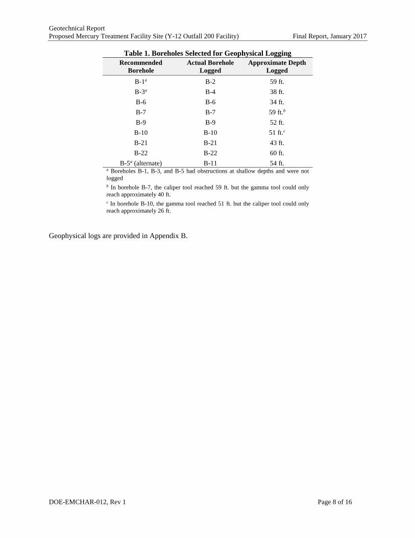
Geophysical logging was conducted on November 15-16, 2016. Some of the boreholes selected for
logging had obstructions or cave-ins and some were not completely vertical due to difficulties
encountered with drilling through multiple voids. Decisions on which boreholes to log were made in
consultation with the Outfall 200 MTF design contractor representative on site. Table 1 provides a list of
recommended boreholes versus actual boreholes logged. Some factors prevented the recommended
boreholes from being logged or precluded logging of the full depth of the boreholes. Because of several
factors, including the lighter weight of the logging tools being lowered on a cable compared to the 1-inch
PVC used to test the borehole integrity, length of the logging tools, and presence of voids (or other issues
related to borehole integrity), only a few borings could be logged to total depth. The configuration of the
downhole probes would occasionally not allow advancement through soft materials. Significant voids
identified in the geotechnical boring logs also caused difficulty in geophysical logging.
Geotechnical Report
Proposed Mercury Treatment Facility Site (Y-12 Outfall 200 Facility) Final Report, January 2017
DOE-EMCHAR-012, Rev 1 Page 8 of 16
Table 1. Boreholes Selected for Geophysical Logging
Recommended
Borehole
Actual Borehole
Logged
Approximate Depth
Logged
B-1a B-2 59 ft.
B-3a B-4 38 ft.
B-6 B-6 34 ft.
B-7 B-7 59 ft.b
B-9 B-9 52 ft.
B-10 B-10 51 ft.c
B-21 B-21 43 ft.
B-22 B-22 60 ft.
B-5a (alternate) B-11 54 ft. a Boreholes B-1, B-3, and B-5 had obstructions at shallow depths and were not
logged
b In borehole B-7, the caliper tool reached 59 ft. but the gamma tool could only
reach approximately 40 ft.
c In borehole B-10, the gamma tool reached 51 ft. but the caliper tool could only
reach approximately 26 ft.
Geophysical logs are provided in Appendix B.
Geotechnical Report
Proposed Mercury Treatment Facility Site (Y-12 Outfall 200 Facility) Final Report, January 2017
DOE-EMCHAR-012, Rev 1 Page 9 of 16
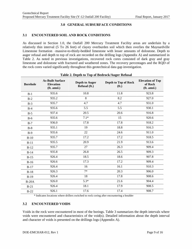
3.0 GENERAL SUBSURFACE CONDITIONS
3.1 ENCOUNTERED SOIL AND ROCK CONDITIONS
As discussed in Section 1.0, the Outfall 200 Mercury Treatment Facility areas are underlain by a
relatively thin interval (5 To 26 feet) of clayey overburden soil which then overlies the Maynardville
Limestone formation –massive-to-thinly-bedded limestone with lesser amounts of dolostone. Depth to
auger refusal and depth to top of rock are recorded on the drilling logs (Appendix A) and summarized in
Table 2. As noted in previous investigations, recovered rock cores consisted of dark gray and gray
limestone and dolostone with fractured and weathered zones. The recovery percentages and the RQD of
the rock cores varied significantly throughout this geotechnical data gap investigation.
Table 2. Depth to Top of Bedrock/Auger Refusal
Borehole
As-Built Surface
Elevation
(ft. amsl.)
Depth to Auger
Refusal (ft.)
Depth to Top of Rock
(ft.)
Elevation of Top
of Rock
(ft. amsl.)
B-1 935.6 10.8 11.8 923.8
B-2 935.2 8 8.2 927.0
B-3 935.7 4.7 4.7 931.0
B-4 935.6 5.5 5.5 930.1
B-5 937.4 20.5 20.6 916.8
B-6 935.6 7.1* 15 920.6
B-7 936.0 17.8 17.8 918.2
B-8 935.1 19 18.8 916.3
B-9 935.6 22 24.6 911.0
B-10 935.7 17.2 17.2 918.5
B-11 935.5 20.9 21.9 913.6
B-12 935.7 27 26.3 909.4
B-14 935.8 26.8 26.5 909.3
B-15 926.4 18.5 18.6 907.8
B-16 926.6 17.3 17.2 909.4
B-17 926.4 16 16.1 910.3
B-18 926.3 7* 20.3 906.0
B-19 926.4 18 17.8 908.6
B-20A 926.0 5.3* 21.6 904.4
B-21 926.4 18.1 17.9 908.5
B-22 926.1 17.6 17.4 908.7
* Indicates locations where drillers switched to rock coring after encountering a boulder
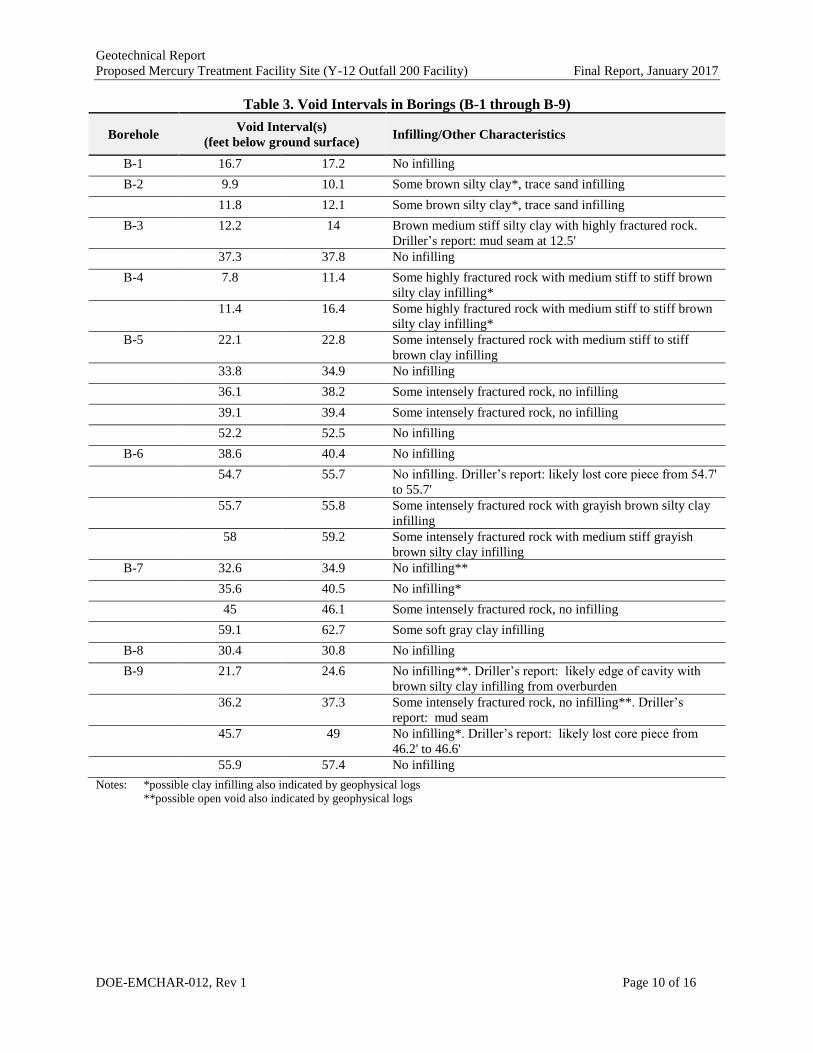
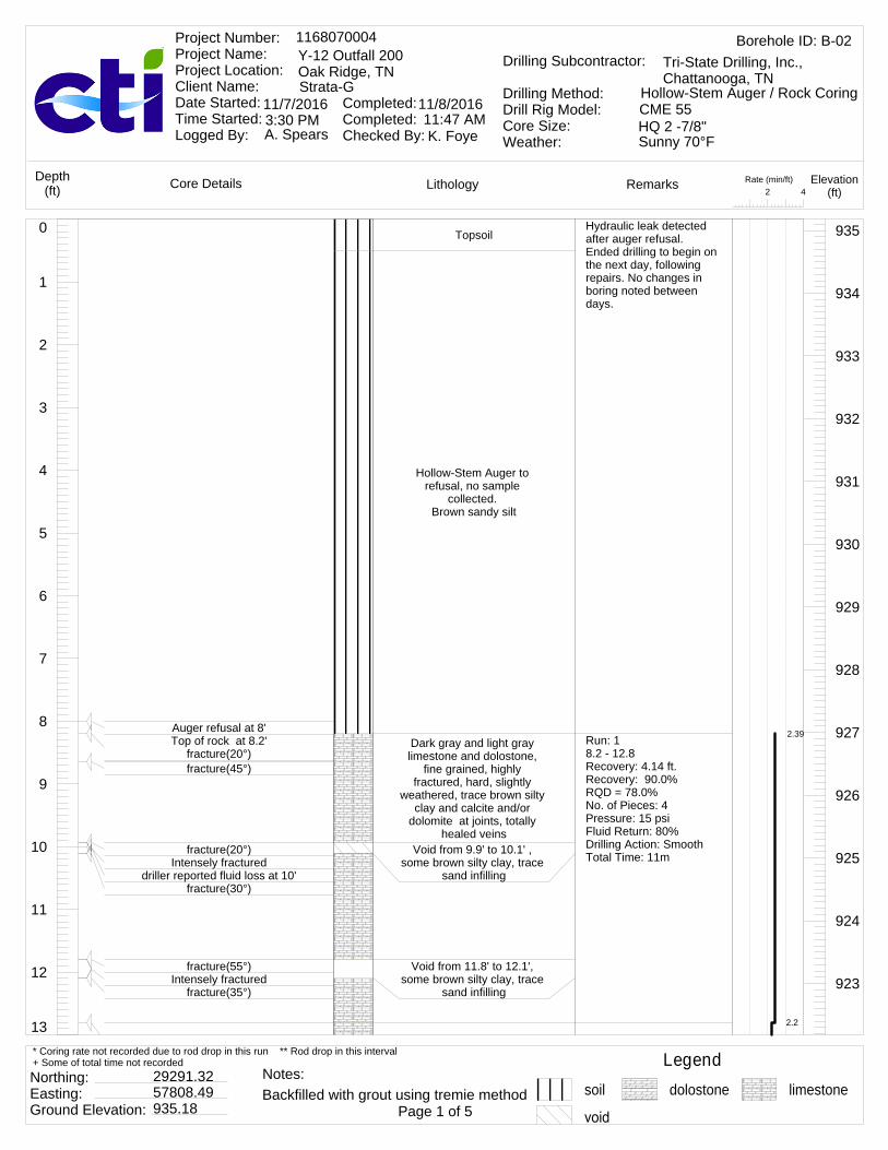
3.2 ENCOUNTERED VOIDS
Voids in the rock were encountered in most of the borings. Table 3 summarizes the depth intervals where
voids were encountered and characteristics of the void(s). Detailed information about the depth interval
and character of voids is presented on the drillings logs (Appendix A).
Geotechnical Report
Proposed Mercury Treatment Facility Site (Y-12 Outfall 200 Facility) Final Report, January 2017
DOE-EMCHAR-012, Rev 1 Page 10 of 16
Table 3. Void Intervals in Borings (B-1 through B-9)
Borehole Void Interval(s)
(feet below ground surface) Infilling/Other Characteristics
B-1 16.7 17.2 No infilling
B-2 9.9 10.1 Some brown silty clay*, trace sand infilling
11.8 12.1 Some brown silty clay*, trace sand infilling
B-3 12.2 14 Brown medium stiff silty clay with highly fractured rock.
Driller’s report: mud seam at 12.5'
37.3 37.8 No infilling
B-4 7.8 11.4 Some highly fractured rock with medium stiff to stiff brown
silty clay infilling*
11.4 16.4 Some highly fractured rock with medium stiff to stiff brown
silty clay infilling*
B-5 22.1 22.8 Some intensely fractured rock with medium stiff to stiff
brown clay infilling
33.8 34.9 No infilling
36.1 38.2 Some intensely fractured rock, no infilling
39.1 39.4 Some intensely fractured rock, no infilling
52.2 52.5 No infilling
B-6 38.6 40.4 No infilling
54.7 55.7 No infilling. Driller’s report: likely lost core piece from 54.7'
to 55.7'
55.7 55.8 Some intensely fractured rock with grayish brown silty clay
infilling
58 59.2 Some intensely fractured rock with medium stiff grayish
brown silty clay infilling
B-7 32.6 34.9 No infilling**
35.6 40.5 No infilling*
45 46.1 Some intensely fractured rock, no infilling
59.1 62.7 Some soft gray clay infilling
B-8 30.4 30.8 No infilling
B-9 21.7 24.6 No infilling**. Driller’s report: likely edge of cavity with
brown silty clay infilling from overburden
36.2 37.3 Some intensely fractured rock, no infilling**. Driller’s
report: mud seam
45.7 49 No infilling*. Driller’s report: likely lost core piece from
46.2' to 46.6'
55.9 57.4 No infilling
Notes: *possible clay infilling also indicated by geophysical logs
**possible open void also indicated by geophysical logs
Geotechnical Report
Proposed Mercury Treatment Facility Site (Y-12 Outfall 200 Facility) Final Report, January 2017
DOE-EMCHAR-012, Rev 1 Page 11 of 16
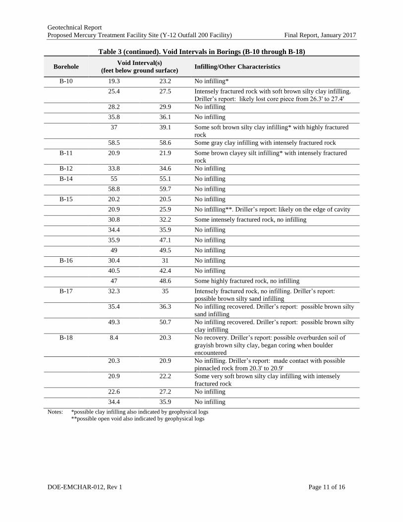
Table 3 (continued). Void Intervals in Borings (B-10 through B-18)
Borehole Void Interval(s)
(feet below ground surface) Infilling/Other Characteristics
B-10 19.3 23.2 No infilling*
25.4 27.5 Intensely fractured rock with soft brown silty clay infilling.
Driller’s report: likely lost core piece from 26.3' to 27.4'
28.2 29.9 No infilling
35.8 36.1 No infilling
37 39.1 Some soft brown silty clay infilling* with highly fractured
rock
58.5 58.6 Some gray clay infilling with intensely fractured rock
B-11 20.9 21.9 Some brown clayey silt infilling* with intensely fractured
rock
B-12 33.8 34.6 No infilling
B-14 55 55.1 No infilling
58.8 59.7 No infilling
B-15 20.2 20.5 No infilling
20.9 25.9 No infilling**. Driller’s report: likely on the edge of cavity
30.8 32.2 Some intensely fractured rock, no infilling
34.4 35.9 No infilling
35.9 47.1 No infilling
49 49.5 No infilling
B-16 30.4 31 No infilling
40.5 42.4 No infilling
47 48.6 Some highly fractured rock, no infilling
B-17 32.3 35 Intensely fractured rock, no infilling. Driller’s report:
possible brown silty sand infilling
35.4 36.3 No infilling recovered. Driller’s report: possible brown silty
sand infilling
49.3 50.7 No infilling recovered. Driller’s report: possible brown silty
clay infilling
B-18 8.4 20.3 No recovery. Driller’s report: possible overburden soil of
grayish brown silty clay, began coring when boulder
encountered
20.3 20.9 No infilling. Driller’s report: made contact with possible
pinnacled rock from 20.3' to 20.9'
20.9 22.2 Some very soft brown silty clay infilling with intensely
fractured rock
22.6 27.2 No infilling
34.4 35.9 No infilling
Notes: *possible clay infilling also indicated by geophysical logs
**possible open void also indicated by geophysical logs
Geotechnical Report
Proposed Mercury Treatment Facility Site (Y-12 Outfall 200 Facility) Final Report, January 2017
DOE-EMCHAR-012, Rev 1 Page 12 of 16
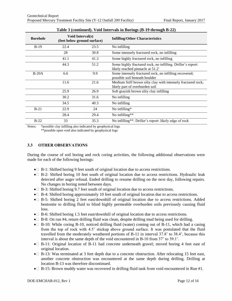
Table 3 (continued). Void Intervals in Borings (B-19 through B-22)
Borehole Void Interval(s)
(feet below ground surface) Infilling/Other Characteristics
B-19 22.4 23.5 No infilling
28 30.8 Some intensely fractured rock, no infilling
41.1 41.3 Some highly fractured rock, no infilling
44.3 51.2 Some highly fractured rock, no infilling. Driller’s report:
likely reached pinnacle at 51.2'
B-20A 6.6 9.9 Some intensely fractured rock, no infilling recovered;
possible soil beneath boulder
11.6 21.6 Medium Stiff brown silty clay with intensely fractured rock;
likely part of overburden soil
25.9 26.9 Soft grayish brown silty clay infilling
30.2 31.6 No infilling
34.5 40.3 No infilling
B-21 22.9 24 No infilling*
28.4 29.4 No infilling**
B-22 33 35.3 No infilling**. Driller’s report: likely edge of rock
Notes: *possible clay infilling also indicated by geophysical logs
**possible open void also indicated by geophysical logs
3.3 OTHER OBSERVATIONS
During the course of soil boring and rock coring activities, the following additional observations were
made for each of the following borings:
B-1: Shifted boring 9 feet south of original location due to access restrictions.
B-2: Shifted boring 10 feet south of original location due to access restrictions. Hydraulic leak
detected after auger refusal. Ended drilling to resume drilling on the next day, following repairs.
No changes in boring noted between days.
B-3: Shifted boring 9.7 feet south of original location due to access restrictions.
B-4: Shifted boring approximately 10 feet south of original location due to access restrictions.
B-5: Shifted boring 2 feet east/downhill of original location due to access restrictions. Added
bentonite to drilling fluid to blind highly permeable overburden soils previously causing fluid
loss.
B-6: Shifted boring 1.5 feet east/downhill of original location due to access restrictions.
B-8: On run #4, return drilling fluid was clean, despite drilling mud being used for drilling.
B-10: While coring B-10, noticed drilling fluid (water) coming out of B-11, which had a casing
from the top of rock with 4.5’ stickup above ground surface. It was postulated that the fluid
travelled from the moderately weathered portions of B-11 in interval 37.8’ to 38.4’, because this
interval is about the same depth of the void encountered in B-10 from 37’ to 39.1’.
B-11: Original location of B-11 had concrete underneath gravel; moved boring 4 feet east of
original location.
B-13: Was terminated at 3 feet depth due to a concrete obstruction. After relocating 15 feet east,
another concrete obstruction was encountered at the same depth during drilling. Drilling at
location B-13 was therefore discontinued.
B-15: Brown muddy water was recovered in drilling fluid tank from void encountered in Run #1.

Geotechnical Report
Proposed Mercury Treatment Facility Site (Y-12 Outfall 200 Facility) Final Report, January 2017
DOE-EMCHAR-012, Rev 1 Page 13 of 16
B-18: Top of rock was indicated as 20.3’ although auger refusal was at 8.4’ due to encountering a
boulder at 8.4’. Although there was no recovery using the HQ wireline system after encountering
the boulder, the drillers reported that overburden soil was encountered.
B-20: While drilling B-20, encountered a heavy gaged steel pipe at a depth of 10.5’. Drilling did
not break the pipe. Abandoned hole and appropriate site representatives visited to consult on
where the new boring should be drilled.
B-20A: Shifted boring 3 feet west of B-20 location due to encountering a buried utility at the
original location. At a depth between 6.6’ to 11.6’, the driller smelled a scent similar to lighter
fluid and stopped drilling until the problem was resolved. Top of rock was indicated as 21.6’
although auger refusal was at 5.3’ due to encountering a boulder at 5.3’. Although there was no
recovery using the HQ wireline system after encountering the boulder, the drillers reported that
overburden soil was encountered.
B-22: Industrial hygienist detected trichloroethylene (TCE) above acceptable levels in soil.
Halted operations and continued on the next workday. No detection the next day.
3.4 HEADCUT ERODIBILITY INDEX
The engineering analysis consisted of calculating the headcut erodibility index (USDA Headcut
Erodibility Index Manual 2001) for the rock encountered during the rock core drilling activities
performed at the site. This information is presented to aid readers of this report in their assessment of
anticipated working conditions when excavating at the site. The headcut erodibility index predicts the
effort required for excavation of the rock, expressed in flywheel horsepower (hp), based on the strength of
the rock, the RQD, the roughness and size of the joints in the rock, and the ground structure of joints in
the rock strata. The calculation of the headcut erodibility index was performed for the top 5-foot interval
from two representative core runs – one with relatively weathered and jointed rock and one with relatively
intact rock – in order to bracket the anticipated excavation conditions based on the rock cores performed.
The calculation of the headcut erodibility index is explained below.
The dimensionless headcut erodibility index is the scalar product of four indices and is calculated using
Equation 1 (USDA Headcut Erodibility Index Manual 2001).
sdbsh JKKMK (1)
where
Kh = headcut erodibility index
Ms = material strength number of the earth material
Kb = block or particle size number
Kd = discontinuity or interparticle bond shear strength number
Js = relative ground structure number
3.4.1 Material Strength Number
The dimensionless material strength number (Ms) for rocks is approximately defined using the uniaxial
compressive strength (UCS) of rocks by Equation 2.
Ms = UCS for UCS > 10 MPa (2)
Geotechnical Report
Proposed Mercury Treatment Facility Site (Y-12 Outfall 200 Facility) Final Report, January 2017
DOE-EMCHAR-012, Rev 1 Page 14 of 16
where
UCS = uniaxial compressive strength of the intact rock sample [MPa]
The range of UCS values determined from laboratory testing performed by GEOSerives (2016) is used in
this analysis to determine the overall range of anticipated headcut erodibility index (Kh) values.
GEOSerives (2016) tested selected rock cores and obtained values of UCS between 59 and 142 MPa. For
this analysis, a value of 59 MPa is paired with the low RQD value and a value of 142 MPa is paired with
the high RQD value to obtain the maximum and minimum estimates of Kh.
3.4.2 Block or Particle Size Number
For rocks, the primary method to calculate the block number (Kb) is using Equation 3.
n
bJ
RQDK (3)
where
RQD = rock quality designation [%]
Jn = joint set number
The RQD of all core runs was calculated as explained in the earlier sections and the results are presented
in Appendix A. The joint set number is a scale factor accounting for the shape of the material units or the
relative occurrence of different joint sets (USDA Headcut Erodibility Index Manual 2001). The joint set
number of each core run was assigned in accordance with the USDA Headcut Erodibility Index Manual
(2001) and is presented in Table 4.
3.4.3 Discontinuity or Interparticle Bond Shear Strength Number
The discontinuity or interparticle bond shear strength number (Kd) is calculated using Equation 4.
a
rd
J
JK (4)
where
Jr = joint roughness number
Ja = joint alteration number
The joint roughness number represents the degree of roughness of opposing faces of a rock discontinuity
and the joint alteration number represents the degree of alteration of the materials that form the faces.
General observations of the joint roughness and degree of alteration of materials were made during rock
coring. Rock coring illustrations on the written boring logs provided further insight to these values. Both
numbers were obtained from tables presented in the USDA Headcut Erodibility Index Manual (2001) and
are presented in Table 4.
Geotechnical Report
Proposed Mercury Treatment Facility Site (Y-12 Outfall 200 Facility) Final Report, January 2017
DOE-EMCHAR-012, Rev 1 Page 15 of 16
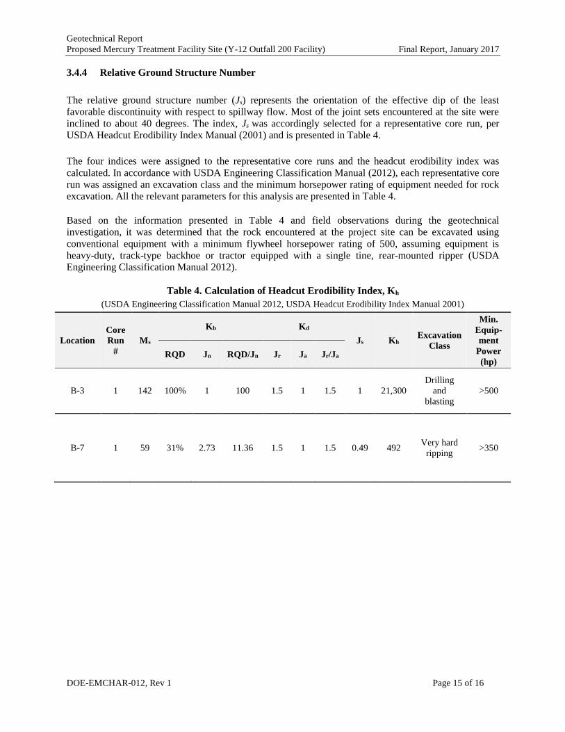
3.4.4 Relative Ground Structure Number
The relative ground structure number (Js) represents the orientation of the effective dip of the least
favorable discontinuity with respect to spillway flow. Most of the joint sets encountered at the site were
inclined to about 40 degrees. The index, Js was accordingly selected for a representative core run, per
USDA Headcut Erodibility Index Manual (2001) and is presented in Table 4.
The four indices were assigned to the representative core runs and the headcut erodibility index was
calculated. In accordance with USDA Engineering Classification Manual (2012), each representative core
run was assigned an excavation class and the minimum horsepower rating of equipment needed for rock
excavation. All the relevant parameters for this analysis are presented in Table 4.
Based on the information presented in Table 4 and field observations during the geotechnical
investigation, it was determined that the rock encountered at the project site can be excavated using
conventional equipment with a minimum flywheel horsepower rating of 500, assuming equipment is
heavy-duty, track-type backhoe or tractor equipped with a single tine, rear-mounted ripper (USDA
Engineering Classification Manual 2012).
Table 4. Calculation of Headcut Erodibility Index, Kh
(USDA Engineering Classification Manual 2012, USDA Headcut Erodibility Index Manual 2001)
Location
Core
Run
#
Ms
Kb Kd
Js Kh Excavation
Class
Min.
Equip-
ment
Power
(hp) RQD Jn RQD/Jn Jr Ja Jr/Ja
B-3 1 142 100% 1 100 1.5 1 1.5 1 21,300
Drilling
and
blasting
>500
B-7 1 59 31% 2.73 11.36 1.5 1 1.5 0.49 492 Very hard
ripping >350

Geotechnical Report
Proposed Mercury Treatment Facility Site (Y-12 Outfall 200 Facility) Final Report, January 2017
DOE-EMCHAR-012, Rev 1 Page 16 of 16
4.0 REFERENCES
GEOServices 2016. Report of Limited Geotechnical Exploration, Outfall 200 Mercury Treatment Facility
– Oak Ridge, Tennessee.
U.S. Department of Agriculture 2001. Headcut Erodibility Index Manual. “Chapter 52 – Field Procedures
Guide for the Headcut Erodibility Index”, Part 628 Dams, National Engineering Handbook, Natural
Resources Conservation Service, Revised March 2001.
U.S. Department of Agriculture 2012. Engineering Classification Manual. “Chapter 4 – Engineering
Classification of Rock Materials”, Part 631 Geology, National Engineering Handbook, Natural Resources
Conservation Service, Issued January 2012.
U.S. Department of Energy (DOE) 1998. Report on the Remedial Investigation of the Upper East Fork
Poplar Creek Characterization Area at the Oak Ridge Y-12 Plant, Oak Ridge Tennessee, DOE/OR/01-
1641/V2&D2, Appendix C.
DOE 2002. Record of Decision for Phase I Interim Source Control Actions in the Upper East Fork
Poplar Creek Characterization Area, Oak Ridge Tennessee, DOE/OR/01-1951&D3.
DOE 2006. Record of Decision for Phase II Interim Remedial Actions for Contaminated Soils and
Scrapyard in Upper East Fork Poplar Creek, Oak Ridge Tennessee, DOE/OR/01-2229&D3.
DOE 2009. Controlling Mercury Source Zones to Surface Water: Initial Results of Pilot Studies at the Y-
12 National Security Complex, ORNL/TM-2009/035, January 2009.
U.S. Geological Survey. http://mrdata.usgs.gov/geology/state/state.php?state=TN. Accessed January
2016.
URS/CH2M Oak Ridge LLC (UCOR) 2013. Conceptual Design for Outfall 200 Mercury Treatment
Facility, Final Report. January 2013.
GEOTECHNICAL REPORT FOR DATA GAP
CHARACTERIZATION AT THE PROPOSED OUTFALL 200
MERCURY TREATMENT FACILITY SITES
January 2017
Appendix A – Boring Logs

13
12
11
10
9
8
7
6
5
4
3
2
1
0 Topsoil and gray gravel
Hollow-Stem Auger to refusal, no sample
collected. Brown silty sand, brown
clayey silt, and brown silty clay
Brown silty clay, trace gravel and organics
Dark gray and light gray limestone and dolostone, fine grained, moderately fractured, hard, slightly
935
934
933
932
931
930
929
928
927
926
925
924
923
Auger refusal at 10.8' (possible boulder)
Top of rock at 11.8'fracture(20°)
fracture(65°)
Run: 111.8 - 12.6Recovery: 0.8 ft.Recovery: 100.0% 2.02
Rate (min/ft)42
LithologyCore Details RemarksDepth(ft)
Elevation(ft)
Borehole ID: B-011168070004Y-12 Outfall 200Oak Ridge, TNStrata-G
Project Number: Project Name: Project Location: Client Name: Date Started: Time Started: Logged By:
Completed: Completed: Checked By:
11/10/2016 11/10/2016
A. Spears K. Foye
Drilling Subcontractor:
Drilling Method:Drill Rig Model:Core Size:Weather:
Tri-State Drilling, Inc., Chattanooga, TN
Hollow-Stem Auger / Rock CoringCME 55HQ 2 -7/8"7:30 AM 11:18 AMMostly Cloudy 39°F
Legendsoil dolostone limestone
Northing: Easting: Ground Elevation:
29296.3457771.68935.55 Page 1 of 5
* Coring rate not recorded due to rod drop in this run ** Rod drop in this interval+ Some of total time not recorded
Backfilled with grout using tremie methodNotes:

26
25
24
23
22
21
20
19
18
17
16
15
14
13 clay and calcite and/or dolomite at joints, totally healed veins, occasional
totally healed calcite and/or dolomite veins
Dark gray and light gray limestone and dolostone, fine grained, moderately fractured, hard, slightly
weathered, trace brown silty clay and calcite and/or
dolomite at joints, totally healed veins, occasional
totally healed calcite and/or dolomite veins
void from 16.7' to 17.2', no infilling
Dark gray and light gray limestone and dolostone, fine grained, moderately fractured, hard, slightly
weathered, trace brown silty clay and calcite and/or
dolomite at joints, totally healed veins, occasional
totally healed calcite and/or dolomite veins
Dark gray and light gray limestone and dolostone,
fine grained, slightly fractured, hard, slightly
weathered, trace brown silty clay and calcite and/or
dolomite at joints,
922
921
920
919
918
917
916
915
914
913
912
911
910
fracture(0°)
fracture(0°)Highly fractured
fracture(65°)
fracture(40°)
fracture(35°)
fracture(70°)
fracture(20°)
No. of Pieces: 3Pressure: 10 psiFluid Return: 100%Drilling Action: SmoothTotal Time: 4m:54sRun: 212.6 - 17.6Recovery: 4.5 ft.Recovery: 90.0%RQD = 82.0%No. of Pieces: 2Pressure: 10 psiFluid Return: 0%Drilling Action: SmoothTotal Time: 10m:14s
Run: 317.6 - 22.6Recovery: 5.1 ft.Recovery: 102.0%RQD = 100.0%No. of Pieces: 3Pressure: 10 psiFluid Return: 0%Drilling Action: SmoothTotal Time: 6m:11s
Run: 422.6 - 27.6Recovery: 4.9 ft.Recovery: 98.0%RQD = 100.0%No. of Pieces: 3Pressure: 12 psiFluid Return: 0%Drilling Action: SmoothTotal Time: 6m:47s
1.58
1.78
1.68
3.15
1.23
1.28
1.4
1.08
1.2
1.75
1.08
1.33
1.23
Rate (min/ft)42
LithologyCore Details RemarksDepth(ft)
Elevation(ft)
Borehole ID: B-011168070004Y-12 Outfall 200Oak Ridge, TNStrata-G
Project Number: Project Name: Project Location: Client Name: Date Started: Time Started: Logged By:
Completed: Completed: Checked By:
11/10/2016 11/10/2016
A. Spears K. Foye
Drilling Subcontractor:
Drilling Method:Drill Rig Model:Core Size:Weather:
Tri-State Drilling, Inc., Chattanooga, TN
Hollow-Stem Auger / Rock CoringCME 55HQ 2 -7/8"7:30 AM 11:18 AMMostly Cloudy 39°F
Legendsoil dolostone limestone
Northing: Easting: Ground Elevation:
29296.3457771.68935.55 Page 2 of 5
* Coring rate not recorded due to rod drop in this run ** Rod drop in this interval+ Some of total time not recorded
Backfilled with grout using tremie methodNotes:

39
38
37
36
35
34
33
32
31
30
29
28
27
26 healed veins
Dark gray and light gray limestone and dolostone, fine grained, unfractured, hard, slightly weathered, trace brown silty clay and calcite and/or dolomite at joints, totally healed veins
Dark gray and light gray limestone and dolostone, fine grained, moderately
fractured to highly fractured, hard, slightly weathered, trace brown silty clay and calcite and/or dolomite at joints, totally healed veins
909
908
907
906
905
904
903
902
901
900
899
898
897
fracture(45°)
fracture(0°)
fracture(0°)
fracture(25°)
fracture(35°)
fracture(0°)fracture(45°)
Intensely fracturedfracture(40°)
fracture(30°)
fracture(0°)
Run: 527.6 - 32.6Recovery: 5.1 ft.Recovery: 102.0%RQD = 100.0%No. of Pieces: 1Pressure: 12 psiFluid Return: 0%Drilling Action: SmoothTotal Time: 10m:30s
Run: 632.6 - 37.6Recovery: 4.9 ft.Recovery: 98.0%RQD = 90.0%No. of Pieces: 9Pressure: 12 psiFluid Return: 0%Drilling Action: SmoothTotal Time: 8m:36s
Run: 737.6 - 42.6Recovery: 5 ft.Recovery: 100.0%RQD = 100.0%
1.4
2.58
2.52
1.78
1.53
2.1
1.63
1.8
0.717
0.95
Rate (min/ft)42
LithologyCore Details RemarksDepth(ft)
Elevation(ft)
Borehole ID: B-011168070004Y-12 Outfall 200Oak Ridge, TNStrata-G
Project Number: Project Name: Project Location: Client Name: Date Started: Time Started: Logged By:
Completed: Completed: Checked By:
11/10/2016 11/10/2016
A. Spears K. Foye
Drilling Subcontractor:
Drilling Method:Drill Rig Model:Core Size:Weather:
Tri-State Drilling, Inc., Chattanooga, TN
Hollow-Stem Auger / Rock CoringCME 55HQ 2 -7/8"7:30 AM 11:18 AMMostly Cloudy 39°F
Legendsoil dolostone limestone
Northing: Easting: Ground Elevation:
29296.3457771.68935.55 Page 3 of 5
* Coring rate not recorded due to rod drop in this run ** Rod drop in this interval+ Some of total time not recorded
Backfilled with grout using tremie methodNotes:

52
51
50
49
48
47
46
45
44
43
42
41
40
39Dark gray and light gray limestone and dolostone,
fine grained, slightly fractured, hard, slightly
weathered, trace brown silty clay and calcite and/or
dolomite at joints, totally healed veins
Dark gray and light gray limestone and dolostone, fine grained, moderately fractured, hard, slightly
weathered, trace brown silty clay and calcite and/or
dolomite at joints, totally healed veins
Dark gray and light gray limestone and dolostone,
fine grained, slightly fractured, hard, slightly
weathered, trace brown silty clay and calcite and/or
dolomite at joints, occasional moderately
healed veins
896
895
894
893
892
891
890
889
888
887
886
885
884
fracture(30°)
fracture(0°)
fracture(0°)fracture(45°)
fracture(20°)
fracture(20°)
fracture(25°)Intensely fractured
fracture(0°)
fracture(15°)
Pressure: 12 psiFluid Return: 0%Drilling Action: SmoothTotal Time: 4m:57s
Run: 842.6 - 47.6Recovery: 4.9 ft.Recovery: 98.0%RQD = 93.0%No. of Pieces: 5Pressure: 12 psiFluid Return: 0%Drilling Action: SmoothTotal Time: 5m:24s
Run: 947.6 - 52.6Recovery: 4.9 ft.Recovery: 98.0%RQD = 98.0%No. of Pieces: 2Pressure: 12 psiFluid Return: 0%Drilling Action: SmoothTotal Time: 4m:37s
1
1.07
1.08
0.923
Rate (min/ft)42
LithologyCore Details RemarksDepth(ft)
Elevation(ft)
Borehole ID: B-011168070004Y-12 Outfall 200Oak Ridge, TNStrata-G
Project Number: Project Name: Project Location: Client Name: Date Started: Time Started: Logged By:
Completed: Completed: Checked By:
11/10/2016 11/10/2016
A. Spears K. Foye
Drilling Subcontractor:
Drilling Method:Drill Rig Model:Core Size:Weather:
Tri-State Drilling, Inc., Chattanooga, TN
Hollow-Stem Auger / Rock CoringCME 55HQ 2 -7/8"7:30 AM 11:18 AMMostly Cloudy 39°F
Legendsoil dolostone limestone
Northing: Easting: Ground Elevation:
29296.3457771.68935.55 Page 4 of 5
* Coring rate not recorded due to rod drop in this run ** Rod drop in this interval+ Some of total time not recorded
Backfilled with grout using tremie methodNotes:

60
59
58
57
56
55
54
53
52
Dark gray and light gray limestone and dolostone,
fine grained, slightly to moderately fractured, hard,
slightly weathered, trace brown silty clay and calcite and/or dolomite at joints, moderately healed veins with brown silty clay infill
Dark gray and light gray limestone and dolostone, fine grained, moderately fractured, hard, slightly
weathered, trace brown silty clay and calcite and/or
dolomite at joints, totally healed veins
End of boring recovery at 60'
883
882
881
880
879
878
877
876
fracture(0°)
fracture(25°)
fracture(35°)
fracture(0°)
fracture(35°)
fracture(70°)
Run: 1052.6 - 57.6Recovery: 5 ft.Recovery: 100.0%RQD = 100.0%No. of Pieces: 3Pressure: 12 psiFluid Return: 0%Drilling Action: SmoothTotal Time: 5m:05s
Run: 1157.6 - 60.2Recovery: 2.6 ft.Recovery: 100.0%RQD = 83.3%No. of Pieces: 4Pressure: 12 psiFluid Return: 0%Drilling Action: SmoothTotal Time: 3m:12s
1.02
1.23
Rate (min/ft)42
LithologyCore Details RemarksDepth(ft)
Elevation(ft)
Borehole ID: B-011168070004Y-12 Outfall 200Oak Ridge, TNStrata-G
Project Number: Project Name: Project Location: Client Name: Date Started: Time Started: Logged By:
Completed: Completed: Checked By:
11/10/2016 11/10/2016
A. Spears K. Foye
Drilling Subcontractor:
Drilling Method:Drill Rig Model:Core Size:Weather:
Tri-State Drilling, Inc., Chattanooga, TN
Hollow-Stem Auger / Rock CoringCME 55HQ 2 -7/8"7:30 AM 11:18 AMMostly Cloudy 39°F
Legendsoil dolostone limestone
Northing: Easting: Ground Elevation:
29296.3457771.68935.55 Page 5 of 5
* Coring rate not recorded due to rod drop in this run ** Rod drop in this interval+ Some of total time not recorded
Backfilled with grout using tremie methodNotes:
13
12
11
10
9
8
7
6
5
4
3
2
1
0 Topsoil
Hollow-Stem Auger to refusal, no sample
collected. Brown sandy silt
Dark gray and light gray limestone and dolostone,
fine grained, highly fractured, hard, slightly
weathered, trace brown silty clay and calcite and/or
dolomite at joints, totally healed veins
Void from 9.9' to 10.1' , some brown silty clay, trace
sand infilling
Void from 11.8' to 12.1', some brown silty clay, trace
sand infilling
935
934
933
932
931
930
929
928
927
926
925
924
923
Auger refusal at 8'Top of rock at 8.2'
fracture(20°)fracture(45°)
fracture(20°)Intensely fractured
driller reported fluid loss at 10'fracture(30°)
fracture(55°)Intensely fractured
fracture(35°)
Hydraulic leak detected after auger refusal. Ended drilling to begin on the next day, following repairs. No changes in boring noted between days.
Run: 18.2 - 12.8Recovery: 4.14 ft.Recovery: 90.0%RQD = 78.0%No. of Pieces: 4Pressure: 15 psiFluid Return: 80%Drilling Action: SmoothTotal Time: 11m
2.39
2.2
Rate (min/ft)42
LithologyCore Details RemarksDepth(ft)
Elevation(ft)
Borehole ID: B-021168070004Y-12 Outfall 200Oak Ridge, TNStrata-G
Project Number: Project Name: Project Location: Client Name: Date Started: Time Started: Logged By:
Completed: Completed: Checked By:
11/7/2016 11/8/2016
A. Spears K. Foye
Drilling Subcontractor:
Drilling Method:Drill Rig Model:Core Size:Weather:
Tri-State Drilling, Inc., Chattanooga, TN
Hollow-Stem Auger / Rock CoringCME 55HQ 2 -7/8"3:30 PM 11:47 AMSunny 70°F
Legendsoil dolostone limestone
Northing: Easting: Ground Elevation:
29291.3257808.49935.18 Page 1 of 5
* Coring rate not recorded due to rod drop in this run ** Rod drop in this interval+ Some of total time not recorded
Backfilled with grout using tremie methodNotes:

26
25
24
23
22
21
20
19
18
17
16
15
14
13
Dark gray and light gray limestone and dolostone,
fine grained, slightly fractured, hard, slightly
weathered, trace brown silty clay and calcite and/or
dolomite at joints, totally healed veins
Dark gray and light gray limestone and dolostone,
fine grained, slightly fractured, hard, slightly
weathered, trace brown silty clay and calcite and/or
dolomite at joints, totally healed veins
Dark gray and light gray limestone and dolostone,
fine grained, slightly fractured, hard, slightly
weathered, trace brown silty
922
921
920
919
918
917
916
915
914
913
912
911
910
fracture(0°)
fracture(15°)
fracture(30°)
fracture(20°)
fracture(40°)Highly fractured
Highly fractured
fracture(45°)fracture(0°)
fracture(50°)
fracture(35°)
Run: 212.8 - 17.8Recovery: 4.9 ft.Recovery: 98.0%RQD = 98.0%No. of Pieces: 2Pressure: 75 psiFluid Return: 80%Drilling Action: SmoothTotal Time: 11m
Run: 317.8 - 22.8Recovery: 5.18 ft.Recovery: 103.6%RQD = 96.0%No. of Pieces: 4Pressure: 15 psiFluid Return: 70%Drilling Action: SmoothTotal Time: 15m
Run: 422.8 - 27.8Recovery: 5.05 ft.Recovery: 101.0%RQD = 1.0%No. of Pieces: 4Pressure: 25 psiFluid Return: 70%Drilling Action: SmoothTotal Time: 6m
3
1.17
1.18
1.18
Rate (min/ft)42
LithologyCore Details RemarksDepth(ft)
Elevation(ft)
Borehole ID: B-021168070004Y-12 Outfall 200Oak Ridge, TNStrata-G
Project Number: Project Name: Project Location: Client Name: Date Started: Time Started: Logged By:
Completed: Completed: Checked By:
11/7/2016 11/8/2016
A. Spears K. Foye
Drilling Subcontractor:
Drilling Method:Drill Rig Model:Core Size:Weather:
Tri-State Drilling, Inc., Chattanooga, TN
Hollow-Stem Auger / Rock CoringCME 55HQ 2 -7/8"3:30 PM 11:47 AMSunny 70°F
Legendsoil dolostone limestone
Northing: Easting: Ground Elevation:
29291.3257808.49935.18 Page 2 of 5
* Coring rate not recorded due to rod drop in this run ** Rod drop in this interval+ Some of total time not recorded
Backfilled with grout using tremie methodNotes:

39
38
37
36
35
34
33
32
31
30
29
28
27
26 dolomite at joints, totally healed veins
Dark gray and light gray limestone and dolostone,
fine grained, slightly fractured, hard, slightly
weathered, trace brown silty clay and calcite and/or
dolomite at joints, totally healed veins
Dark gray and light gray limestone and dolostone,
fine grained, slightly fractured, hard, slightly
weathered, trace brown silty clay and calcite and/or
dolomite at joints, totally healed veins
909
908
907
906
905
904
903
902
901
900
899
898
897
fracture(0°)
fracture(0°)Highly fractured
Some brown silt and sand infilling at open joint
fracture(50°)
fracture(50°)
fracture(45°)Highly fractured
fracture(0°)
fracture(55°)
fracture(0°)
Run: 527.8 - 32.8Recovery: 5 ft.Recovery: 100.0%RQD = 100.0%No. of Pieces: 6Pressure: 20 psiFluid Return: 80%Drilling Action: SmoothTotal Time: 5m:03s
Run: 632.8 - 37.8Recovery: 5.1 ft.Recovery: 102.0%RQD = 99.0%No. of Pieces: 4Pressure: 20 psiFluid Return: 70%Drilling Action: SmoothTotal Time: 5m:12s
Run: 737.8 - 42.8Recovery: 5.1 ft.Recovery: 102.0%
1.27
1.17
1.22
1.3
1.22
1.32
1.02
0.983
1.08
1.1
1.07
Rate (min/ft)42
LithologyCore Details RemarksDepth(ft)
Elevation(ft)
Borehole ID: B-021168070004Y-12 Outfall 200Oak Ridge, TNStrata-G
Project Number: Project Name: Project Location: Client Name: Date Started: Time Started: Logged By:
Completed: Completed: Checked By:
11/7/2016 11/8/2016
A. Spears K. Foye
Drilling Subcontractor:
Drilling Method:Drill Rig Model:Core Size:Weather:
Tri-State Drilling, Inc., Chattanooga, TN
Hollow-Stem Auger / Rock CoringCME 55HQ 2 -7/8"3:30 PM 11:47 AMSunny 70°F
Legendsoil dolostone limestone
Northing: Easting: Ground Elevation:
29291.3257808.49935.18 Page 3 of 5
* Coring rate not recorded due to rod drop in this run ** Rod drop in this interval+ Some of total time not recorded
Backfilled with grout using tremie methodNotes:

52
51
50
49
48
47
46
45
44
43
42
41
40
39
Dark gray and light gray limestone and dolostone,
fine grained, slightly fractured, hard, slightly
weathered, trace brown silty clay and calcite and/or
dolomite at joints, totally healed veins
Dark gray and light gray limestone and dolostone,
fine grained, slightly fractured, hard, slightly
weathered, trace brown silty clay and calcite and/or
dolomite at joints, totally healed veins
Dark gray and light gray limestone and dolostone,
fine grained, slightly fractured, hard, slightly
weathered, trace brown silty clay and calcite and/or
dolomite at joints, totally healed veins
896
895
894
893
892
891
890
889
888
887
886
885
884
fracture(0°)
fracture(0°)Intensely fractured
Moderately healed fracture (70°)
fracture(35°)
fracture(0°)
fracture(25°)
fracture(65°)
No. of Pieces: 5Pressure: 20 psiFluid Return: 70%Drilling Action: SmoothTotal Time: 3m:55s
Run: 842.8 - 47.8Recovery: 4.86 ft.Recovery: 97.2%RQD = 96.0%No. of Pieces: 3Pressure: 27.5 psiFluid Return: 80%Drilling Action: SmoothTotal Time: 5m:15s
Run: 947.8 - 52.8Recovery: 5.2 ft.Recovery: 104.0%RQD = 104.0%No. of Pieces: 4Pressure: 27.5 psiFluid Return: 80%Drilling Action: SmoothTotal Time: 5m:24s
0.917
0.967
0.983
1.1
0.95
1.02
1.05
1.13
0.917
1.07
1.08
1.13
1.22
Rate (min/ft)42
LithologyCore Details RemarksDepth(ft)
Elevation(ft)
Borehole ID: B-021168070004Y-12 Outfall 200Oak Ridge, TNStrata-G
Project Number: Project Name: Project Location: Client Name: Date Started: Time Started: Logged By:
Completed: Completed: Checked By:
11/7/2016 11/8/2016
A. Spears K. Foye
Drilling Subcontractor:
Drilling Method:Drill Rig Model:Core Size:Weather:
Tri-State Drilling, Inc., Chattanooga, TN
Hollow-Stem Auger / Rock CoringCME 55HQ 2 -7/8"3:30 PM 11:47 AMSunny 70°F
Legendsoil dolostone limestone
Northing: Easting: Ground Elevation:
29291.3257808.49935.18 Page 4 of 5
* Coring rate not recorded due to rod drop in this run ** Rod drop in this interval+ Some of total time not recorded
Backfilled with grout using tremie methodNotes:
60
59
58
57
56
55
54
53
52
Dark gray and light gray limestone and dolostone, fine grained, unfractured, hard, unweathered, trace
brown silty clay and calcite and/or dolomite at joints,
totally healed veins
Dark gray and light gray limestone and dolostone,
fine grained, slightly fractured, hard, slightly
weathered, trace brown silty clay and calcite and/or
dolomite at joints, totally healed veins
End of boring recovery at 60.4'
883
882
881
880
879
878
877
876
fracture(0°)
fracture(0°)
fracture(20°)
fracture(55°)
Run: 1052.8 - 57.8Recovery: 4.84 ft.Recovery: 96.8%RQD = 97.0%No. of Pieces: 1Pressure: 27.5 psiFluid Return: 80%Drilling Action: SmoothTotal Time: 4m:57s
Run: 1157.8 - 60.2Recovery: 2.35 ft.Recovery: 97.9%RQD = 97.0%No. of Pieces: 2Pressure: 27.5 psiFluid Return: 80%Drilling Action: SmoothTotal Time: 2m:16s +
0.85
0.95
1
0.983
1.2
1.23
1.05
**
Rate (min/ft)42
LithologyCore Details RemarksDepth(ft)
Elevation(ft)
Borehole ID: B-021168070004Y-12 Outfall 200Oak Ridge, TNStrata-G
Project Number: Project Name: Project Location: Client Name: Date Started: Time Started: Logged By:
Completed: Completed: Checked By:
11/7/2016 11/8/2016
A. Spears K. Foye
Drilling Subcontractor:
Drilling Method:Drill Rig Model:Core Size:Weather:
Tri-State Drilling, Inc., Chattanooga, TN
Hollow-Stem Auger / Rock CoringCME 55HQ 2 -7/8"3:30 PM 11:47 AMSunny 70°F
Legendsoil dolostone limestone
Northing: Easting: Ground Elevation:
29291.3257808.49935.18 Page 5 of 5
* Coring rate not recorded due to rod drop in this run ** Rod drop in this interval+ Some of total time not recorded
Backfilled with grout using tremie methodNotes:
13
12
11
10
9
8
7
6
5
4
3
2
1
0 Topsoil, gray gravel
Hollow-Stem Auger to refusal, no sample
collected. Brown silty sand
Dark gray and light gray limestone and dolostone, fine grained, unfractured, hard, slightly weathered, trace brown silty clay and calcite and/or dolomite at joints, totally healed veins
Dark gray and light gray limestone and dolostone,
fine grained, slightly fractured, hard, slightly
weathered, trace brown silty clay and calcite and/or
dolomite at joints, totally healed veins
void from 12.2' to 12.8', no infilling. Driller reported
mud seam at 12.5'
935
934
933
932
931
930
929
928
927
926
925
924
923
Auger refusal/Top of rock at 4.7'Intensely fractured at open joint,
fracture(40°)
fracture(50°)
fracture(0°)
fracture(30°)moderately weathered and some brown
silty clay at open joint
Run: 14.7 - 7.8Recovery: 3.1 ft.Recovery: 100.0%RQD = 100.0%No. of Pieces: 1Pressure: 25 psiFluid Return: 100%Drilling Action: SmoothTotal Time: 7m:45 +
Run: 27.8 - 12.8Recovery: 4.6 ft.Recovery: 92.0%RQD = 87.0%No. of Pieces: 2Pressure: 20 psiFluid Return: 100%Drilling Action: SmoothTotal Time: 11m:40s
3.72
4
2.52
1.07
2.4
2.32
2.25
**
Rate (min/ft)42
LithologyCore Details RemarksDepth(ft)
Elevation(ft)
Borehole ID: B-031168070004Y-12 Outfall 200Oak Ridge, TNStrata-G
Project Number: Project Name: Project Location: Client Name: Date Started: Time Started: Logged By:
Completed: Completed: Checked By:
11/8/2016 11/9/2016
A. Spears K. Foye
Drilling Subcontractor:
Drilling Method:Drill Rig Model:Core Size:Weather:
Tri-State Drilling, Inc., Chattanooga, TN
Hollow-Stem Auger / Rock CoringCME 55HQ 2 -7/8"2:40 PM 8:54 AMMostly Cloudy 70°F
Legendsoil dolostone limestone
Northing: Easting: Ground Elevation:
29286.0657836.83935.69 Page 1 of 5
* Coring rate not recorded due to rod drop in this run ** Rod drop in this interval+ Some of total time not recorded
Backfilled with grout using tremie methodNotes:

26
25
24
23
22
21
20
19
18
17
16
15
14
13 void from 12.8' to 14', brown medium stiff silty clay infilling with intensely
fractured rock
Dark gray and light gray limestone and dolostone, fine grained, moderately
fractured, hard, moderately weathered, trace brown silty
clay and calcite and/or dolomite in joints, totally
healed veins
Dark gray and light gray limestone and dolostone, fine grained, moderately
fractured, hard, moderately weathered, trace brown silty
clay and calcite and/or dolomite in joints, totally
healed veins
Dark gray and light gray limestone and dolostone, fine grained, moderately
fractured, hard, moderately weathered, trace brown silty
clay and calcite and/or
922
921
920
919
918
917
916
915
914
913
912
911
910
fracture(55°)some brown medium stiff silty clay and intensely fractured rock at open joint
fracture(45°)some brown silty clay at open joint
fracture(35°)
fracture(60°)
fracture(25°)
fracture(0°)
fracture(0°)
Intensely fracturedfracture(40°)fracture(20°)
fracture(30°)
fracture(30°)
Brown silty clay stainingfracture(60°)
Run: 312.8 - 17.8Recovery: 3.9 ft.Recovery: 78.0%RQD = 47.0%No. of Pieces: 5Pressure: 20 psiFluid Return: 100%Drilling Action: SmoothTotal Time: 6m:43s
Run: 417.8 - 22.8Recovery: 4.95 ft.Recovery: 99.0%RQD = 97.0%No. of Pieces: 5Pressure: 20 psiFluid Return: 100%Drilling Action: SmoothTotal Time: 5m:59
Run: 522.8 - 27.8Recovery: 5 ft.Recovery: 100.0%RQD = 91.0%No. of Pieces: 5Pressure: 20 psiFluid Return: 100%Drilling Action: SmoothTotal Time: 7m:37s
2.15
1.42
1.57
1.58
1.02
1.08
1.15
1.15
2.05
1.27
1.08
**
Rate (min/ft)42
LithologyCore Details RemarksDepth(ft)
Elevation(ft)
Borehole ID: B-031168070004Y-12 Outfall 200Oak Ridge, TNStrata-G
Project Number: Project Name: Project Location: Client Name: Date Started: Time Started: Logged By:
Completed: Completed: Checked By:
11/8/2016 11/9/2016
A. Spears K. Foye
Drilling Subcontractor:
Drilling Method:Drill Rig Model:Core Size:Weather:
Tri-State Drilling, Inc., Chattanooga, TN
Hollow-Stem Auger / Rock CoringCME 55HQ 2 -7/8"2:40 PM 8:54 AMMostly Cloudy 70°F
Legendsoil dolostone limestone
Northing: Easting: Ground Elevation:
29286.0657836.83935.69 Page 2 of 5
* Coring rate not recorded due to rod drop in this run ** Rod drop in this interval+ Some of total time not recorded
Backfilled with grout using tremie methodNotes:
39
38
37
36
35
34
33
32
31
30
29
28
27
26 healed veins
Dark gray and light gray limestone and dolostone, fine grained, unfractured, hard, unweathered, trace
brown silty clay and calcite and/or dolomite at joints,
totally healed veins
Dark gray and light gray limestone and dolostone,
fine grained, slightly fractured, hard, slightly
weathered, trace brown silty clay and calcite and/or
dolomite at joints, totally healed veins
void from 37.2' to 37.8', no infilling. Driller reported void
from 37.4' to 37.8'
909
908
907
906
905
904
903
902
901
900
899
898
897
fracture(0°)
fracture(25°)
fracture(0°)
driller reported fluid loss at 37.2'
Intensely fractured rock with trace brown silt and sand at open joint
fracture(25°)
Run: 627.8 - 32.8Recovery: 5.1 ft.Recovery: 102.0%RQD = 102.0%No. of Pieces: 1Pressure: 15 psiFluid Return: 100%Drilling Action: SmoothTotal Time: 9m:27s
Run: 732.8 - 37.8Recovery: 4.41666666666667 ft.Recovery: 88.3%RQD = 88.0%No. of Pieces: 2Pressure: 15 psiFluid Return: 35%Drilling Action: SmoothTotal Time: 8:03s +
Run: 837.8 - 42.8Recovery: 4.8 ft.Recovery: 96.0%
1.32
1.93
2
1.67
1.97
1.67
1.97
1.62
1.42
1.37
2.37
2.38
2.05
**
Rate (min/ft)42
LithologyCore Details RemarksDepth(ft)
Elevation(ft)
Borehole ID: B-031168070004Y-12 Outfall 200Oak Ridge, TNStrata-G
Project Number: Project Name: Project Location: Client Name: Date Started: Time Started: Logged By:
Completed: Completed: Checked By:
11/8/2016 11/9/2016
A. Spears K. Foye
Drilling Subcontractor:
Drilling Method:Drill Rig Model:Core Size:Weather:
Tri-State Drilling, Inc., Chattanooga, TN
Hollow-Stem Auger / Rock CoringCME 55HQ 2 -7/8"2:40 PM 8:54 AMMostly Cloudy 70°F
Legendsoil dolostone limestone
Northing: Easting: Ground Elevation:
29286.0657836.83935.69 Page 3 of 5
* Coring rate not recorded due to rod drop in this run ** Rod drop in this interval+ Some of total time not recorded
Backfilled with grout using tremie methodNotes:

52
51
50
49
48
47
46
45
44
43
42
41
40
39Dark gray and light gray limestone and dolostone, fine grained, moderately
fractured, hard, moderately weathered, trace brown silty
clay and calcite and/or dolomite at joints, totally
healed veins
Dark gray and light gray limestone and dolostone, fine grained, unfractured,
hard, moderately weathered, trace brown silty
clay and calcite and/or dolomite at joints, totally
healed veins
Dark gray and light gray limestone and dolostone,
fine grained, slightly fractured, hard, moderately weathered, trace brown silty
clay and calcite and/or dolomite at joints, totally
healed veins
896
895
894
893
892
891
890
889
888
887
886
885
884
fracture(0°)
fracture(0°)
fracture(30°)
Frequent moderately weathered veins with brown silty clay infilling
fracture(0°)
Partly healed vein
No. of Pieces: 8Pressure: 40 psiFluid Return: 0%Drilling Action: SmoothTotal Time: 8m:59s
Run: 942.8 - 47.8Recovery: 5.2 ft.Recovery: 104.0%RQD = 103.0%No. of Pieces: 1Pressure: 15 psiFluid Return: 0%Drilling Action: SmoothTotal Time: 7m:18s
Run: 1047.8 - 52.8Recovery: 5 ft.Recovery: 100.0%RQD = 100.0%No. of Pieces: 2Pressure: 15 psiFluid Return: 0%Drilling Action: SmoothTotal Time: 8m:11s
1.53
1.65
1.85
1.92
1.65
1.32
1.55
Rate (min/ft)42
LithologyCore Details RemarksDepth(ft)
Elevation(ft)
Borehole ID: B-031168070004Y-12 Outfall 200Oak Ridge, TNStrata-G
Project Number: Project Name: Project Location: Client Name: Date Started: Time Started: Logged By:
Completed: Completed: Checked By:
11/8/2016 11/9/2016
A. Spears K. Foye
Drilling Subcontractor:
Drilling Method:Drill Rig Model:Core Size:Weather:
Tri-State Drilling, Inc., Chattanooga, TN
Hollow-Stem Auger / Rock CoringCME 55HQ 2 -7/8"2:40 PM 8:54 AMMostly Cloudy 70°F
Legendsoil dolostone limestone
Northing: Easting: Ground Elevation:
29286.0657836.83935.69 Page 4 of 5
* Coring rate not recorded due to rod drop in this run ** Rod drop in this interval+ Some of total time not recorded
Backfilled with grout using tremie methodNotes:
60
59
58
57
56
55
54
53
52
Dark gray and light gray limestone and dolostone, fine grained, moderately
fractured, hard, moderately weathered, trace brown silt,
brown sand, and calcite and/or dolomite at joints,
totally healed veins
Dark gray and light gray limestone and dolostone,
fine grained, slightly fractured, hard,
unweathered, trace brown silt, brown clay, and calcite and/or dolomite at joints,
totally healed veinsEnd of boring recovery at
60.2'
883
882
881
880
879
878
877
876
fracture(0°)Highly fractured
fracture(0°)Intensely fractured
Frequent moderately weathered veins with trace brown silt and sand infilling
Mechanical breaksfracture(0°)fracture(0°)
Run: 1152.8 - 57.8Recovery: 5 ft.Recovery: 100.0%RQD = 90.8%No. of Pieces: 7Pressure: 65 psiFluid Return: 0%Drilling Action: SmoothTotal Time: 8m:42s
Run: 1257.8 - 60.25Recovery: 2.45 ft.Recovery: 100.0%RQD = 97.0%No. of Pieces: 2Pressure: 15 psiFluid Return: 0%Drilling Action: SmoothTotal Time: 3m:20s
1.83
1.87
1.22
2.07
1.6
1.98
1.52
10.833
Rate (min/ft)42
LithologyCore Details RemarksDepth(ft)
Elevation(ft)
Borehole ID: B-031168070004Y-12 Outfall 200Oak Ridge, TNStrata-G
Project Number: Project Name: Project Location: Client Name: Date Started: Time Started: Logged By:
Completed: Completed: Checked By:
11/8/2016 11/9/2016
A. Spears K. Foye
Drilling Subcontractor:
Drilling Method:Drill Rig Model:Core Size:Weather:
Tri-State Drilling, Inc., Chattanooga, TN
Hollow-Stem Auger / Rock CoringCME 55HQ 2 -7/8"2:40 PM 8:54 AMMostly Cloudy 70°F
Legendsoil dolostone limestone
Northing: Easting: Ground Elevation:
29286.0657836.83935.69 Page 5 of 5
* Coring rate not recorded due to rod drop in this run ** Rod drop in this interval+ Some of total time not recorded
Backfilled with grout using tremie methodNotes:

13
12
11
10
9
8
7
6
5
4
3
2
1
0 Topsoil, gray gravel
Hollow-Stem Auger to refusal, no sample
collected. Brown silty sand
Dark gray and light gray limestone and dolostone, fine grained, moderately fractured, hard, slightly
weathered, trace brown silt, brown sand, organic roots
and fibers, and calcite and/or dolomite in joints,
totally healed veins, occasional calcite and/or
void from 7.8' to 8.1', no infilling
void from 8.1' to 11.4', some highly fractured rock with medium stiff to stiff brown silty clay infilling. Driller
reported mud seam from 8.8' to 16.5'
void from 11.4' to 14.7', no infilling
935
934
933
932
931
930
929
928
927
926
925
924
923
Auger refusal/Top of rock at 5.5'fracture(35°)fracture(35°)
fracture(25°)
fracture(30°)fracture(0°)
Run: 15.3 - 7.8Recovery: 2.5 ft.Recovery: 100.0%RQD = 100.0%No. of Pieces: 4Pressure: 17 psiFluid Return: 100%Drilling Action: SmoothTotal Time: 6m
Run: 27.8 - 12.8Recovery: 3.3 ft.Recovery: 66.0%RQD = 0.0%No. of Pieces: 0Pressure: 110 psiFluid Return: 100%Drilling Action: SmoothTotal Time: 7m
2.61
1.4
1.6
Rate (min/ft)42
LithologyCore Details RemarksDepth(ft)
Elevation(ft)
Borehole ID: B-041168070004Y-12 Outfall 200Oak Ridge, TNStrata-G
Project Number: Project Name: Project Location: Client Name: Date Started: Time Started: Logged By:
Completed: Completed: Checked By:
11/9/2016 11/9/2016
A. Spears K. Foye
Drilling Subcontractor:
Drilling Method:Drill Rig Model:Core Size:Weather:
Tri-State Drilling, Inc., Chattanooga, TN
Hollow-Stem Auger / Rock CoringCME 55HQ 2 -7/8"10:30 AM 3:16 PMMostly Sunny 57°F
Legendsoil dolostone limestone
Northing: Easting: Ground Elevation:
29279.8157900.48935.63 Page 1 of 5
* Coring rate not recorded due to rod drop in this run ** Rod drop in this interval+ Some of total time not recorded
Backfilled with grout using tremie methodNotes:

26
25
24
23
22
21
20
19
18
17
16
15
14
13
void from 14.7' to 16.4', some highly fractured rock
with medium stiff to stiff brown silty clay infilling
Dark gray and light gray limestone and dolostone, fine grained, unfractured, hard, slightly weathered, totally healed veins, trace
brown silt, brown sand, and calcite and/or dolomite in
joints, frequent calcite and/or dolomite totally
healed veins
Dark gray and light gray limestone and dolostone,
fine grained, slightly fractured, hard, slightly
weathered, totally healed veins, frequent calcite and/or dolomite totally
healed veins
Dark gray and light gray limestone and dolostone, fine grained, moderately fractured, hard, slightly
weathered, totally healed veins, some brown silty clay
in joints, frequent calcite
922
921
920
919
918
917
916
915
914
913
912
911
910
fracture(0°)
fracture(0°)
fracture(20°)
fracture(0°)Intensely fractured
Highly weathered , highly fracturedfracture(60°)fracture(25°)
Run: 312.8 - 17.8Recovery: 3.1 ft.Recovery: 62.0%RQD = 25.0%No. of Pieces: 1Pressure: 125 psiFluid Return: 100%Drilling Action: SmoothTotal Time: 8m:01s
Run: 417.8 - 22.8Recovery: 4.8 ft.Recovery: 96.0%RQD = 92.5%No. of Pieces: 3Pressure: 50 psiFluid Return: 0%Drilling Action: SmoothTotal Time: 9m:15s
Run: 522.8 - 27.8Recovery: 5.2 ft.Recovery: 104.0%RQD = 100.0%No. of Pieces: 4Pressure: 17 psiFluid Return: 10%Drilling Action: SmoothTotal Time: 6m:23s
1.85
1.28
Rate (min/ft)42
LithologyCore Details RemarksDepth(ft)
Elevation(ft)
Borehole ID: B-041168070004Y-12 Outfall 200Oak Ridge, TNStrata-G
Project Number: Project Name: Project Location: Client Name: Date Started: Time Started: Logged By:
Completed: Completed: Checked By:
11/9/2016 11/9/2016
A. Spears K. Foye
Drilling Subcontractor:
Drilling Method:Drill Rig Model:Core Size:Weather:
Tri-State Drilling, Inc., Chattanooga, TN
Hollow-Stem Auger / Rock CoringCME 55HQ 2 -7/8"10:30 AM 3:16 PMMostly Sunny 57°F
Legendsoil dolostone limestone
Northing: Easting: Ground Elevation:
29279.8157900.48935.63 Page 2 of 5
* Coring rate not recorded due to rod drop in this run ** Rod drop in this interval+ Some of total time not recorded
Backfilled with grout using tremie methodNotes:

39
38
37
36
35
34
33
32
31
30
29
28
27
26 healed veins
Dark gray and light gray limestone and dolostone,
fine grained, slightly to moderately fractured, hard, slightly weathered, totally healed veins, trace brown silty clay in joints, frequent
calcite and/or dolomite totally healed veins
Dark gray and light gray limestone and dolostone,
fine grained, slightly fractured, hard, slightly
weathered, totally healed veins, frequent calcite and/or dolomite totally
healed veins
909
908
907
906
905
904
903
902
901
900
899
898
897
fracture(30°)
fracture(30°)
fracture(65°)
Intensely fractured
fracture(0°)
fracture(30°)Highly fractured
fracture(0°)
fracture(0°)
Run: 627.8 - 32.8Recovery: 5.13 ft.Recovery: 102.6%RQD = 101.7%No. of Pieces: 3Pressure: 18 psiFluid Return: 30%Drilling Action: SmoothTotal Time: 6m:49s
Run: 732.8 - 37.8Recovery: 4.85 ft.Recovery: 97.0%RQD = 97.0%No. of Pieces: 3Pressure: 17 psiFluid Return: 30%Drilling Action: SmoothTotal Time: 6m
Run: 837.8 - 42.8Recovery: 5.05 ft.Recovery: 101.0%
1.36
1.2
Rate (min/ft)42
LithologyCore Details RemarksDepth(ft)
Elevation(ft)
Borehole ID: B-041168070004Y-12 Outfall 200Oak Ridge, TNStrata-G
Project Number: Project Name: Project Location: Client Name: Date Started: Time Started: Logged By:
Completed: Completed: Checked By:
11/9/2016 11/9/2016
A. Spears K. Foye
Drilling Subcontractor:
Drilling Method:Drill Rig Model:Core Size:Weather:
Tri-State Drilling, Inc., Chattanooga, TN
Hollow-Stem Auger / Rock CoringCME 55HQ 2 -7/8"10:30 AM 3:16 PMMostly Sunny 57°F
Legendsoil dolostone limestone
Northing: Easting: Ground Elevation:
29279.8157900.48935.63 Page 3 of 5
* Coring rate not recorded due to rod drop in this run ** Rod drop in this interval+ Some of total time not recorded
Backfilled with grout using tremie methodNotes:

52
51
50
49
48
47
46
45
44
43
42
41
40
39
Dark gray and light gray limestone and dolostone,
fine grained, moderately to highly fractured, hard,
slightly weathered, totally healed veins, frequent calcite and/or dolomite
totally healed veins
Dark gray and light gray limestone and dolostone,
fine grained, slightly fractured, hard, slightly
weathered, totally healed veins, frequent calcite and/or dolomite totally
healed veins
Dark gray and light gray limestone and dolostone, fine grained, moderately fractured, hard, slightly
weathered, totally healed veins, frequent calcite and/or dolomite totally
healed veins
896
895
894
893
892
891
890
889
888
887
886
885
884
Intensely fracturedfracture(50°)fracture(35°)
Slightly fractured
fracture(50°)
fracture50°)
fracture(67°)
fracture(35°)
fracture(40°)Highly fractured
fracture(30°)
fracture(65°)
No. of Pieces: 5Pressure: 17 psiFluid Return: 35%Drilling Action: SmoothTotal Time: 6m
Run: 942.8 - 47.8Recovery: 5.15 ft.Recovery: 103.0%RQD = 100.0%No. of Pieces: 2Pressure: 17 psiFluid Return: 35%Drilling Action: SmoothTotal Time: 5m:45s
Run: 1047.8 - 52.8Recovery: 5.05 ft.Recovery: 101.0%RQD = 100.0%No. of Pieces: 4Pressure: 17 psiFluid Return: 35%Drilling Action: SmoothTotal Time: 5m:50s
1.2
1.15
Rate (min/ft)42
LithologyCore Details RemarksDepth(ft)
Elevation(ft)
Borehole ID: B-041168070004Y-12 Outfall 200Oak Ridge, TNStrata-G
Project Number: Project Name: Project Location: Client Name: Date Started: Time Started: Logged By:
Completed: Completed: Checked By:
11/9/2016 11/9/2016
A. Spears K. Foye
Drilling Subcontractor:
Drilling Method:Drill Rig Model:Core Size:Weather:
Tri-State Drilling, Inc., Chattanooga, TN
Hollow-Stem Auger / Rock CoringCME 55HQ 2 -7/8"10:30 AM 3:16 PMMostly Sunny 57°F
Legendsoil dolostone limestone
Northing: Easting: Ground Elevation:
29279.8157900.48935.63 Page 4 of 5
* Coring rate not recorded due to rod drop in this run ** Rod drop in this interval+ Some of total time not recorded
Backfilled with grout using tremie methodNotes:

60
59
58
57
56
55
54
53
52
Dark gray and light gray limestone and dolostone, fine grained, moderately
fractured, hard, moderately weathered, totally healed
veins, frequent calcite and/or dolomite totally
healed veins
Dark gray and light gray limestone and dolostone,
fine grained, slightly to moderately fractured, hard,
moderately weathered, totally healed veins,
frequent calcite and/or dolomite totally healed veins
End of boring recovery at 60.6'
883
882
881
880
879
878
877
876
fracture(0°)Highly fractured
fracture(20°)
fracture(25°)
fracture(35°)
fracture(40°)
fracture(50°)
Run: 1152.8 - 57.8Recovery: 4.95 ft.Recovery: 99.0%RQD = 94.0%No. of Pieces: 6Pressure: 17 psiFluid Return: 35%Drilling Action: SmoothTotal Time: 6m:01s
Run: 1257.8 - 60.5Recovery: 2.65 ft.Recovery: 98.1%RQD = 93.0%No. of Pieces: 3Pressure: 17 psiFluid Return: 40%Drilling Action: SmoothTotal Time: 3m:19s
1.17
1.2
1.23
Rate (min/ft)42
LithologyCore Details RemarksDepth(ft)
Elevation(ft)
Borehole ID: B-041168070004Y-12 Outfall 200Oak Ridge, TNStrata-G
Project Number: Project Name: Project Location: Client Name: Date Started: Time Started: Logged By:
Completed: Completed: Checked By:
11/9/2016 11/9/2016
A. Spears K. Foye
Drilling Subcontractor:
Drilling Method:Drill Rig Model:Core Size:Weather:
Tri-State Drilling, Inc., Chattanooga, TN
Hollow-Stem Auger / Rock CoringCME 55HQ 2 -7/8"10:30 AM 3:16 PMMostly Sunny 57°F
Legendsoil dolostone limestone
Northing: Easting: Ground Elevation:
29279.8157900.48935.63 Page 5 of 5
* Coring rate not recorded due to rod drop in this run ** Rod drop in this interval+ Some of total time not recorded
Backfilled with grout using tremie methodNotes:

13
12
11
10
9
8
7
6
5
4
3
2
1
0 Overgrown weeds, gray gravel
Hollow-Stem Auger to refusal, no sample
collected. Dark brown silty sand, and
brown sandy silt with organics
937
936
935
934
933
932
931
930
929
928
927
926
925
Added bentonite to drilling fluid to blind highly permeable overburden soils previously causing fluid loss.
Rate (min/ft)42
LithologyCore Details RemarksDepth(ft)
Elevation(ft)
Borehole ID: B-051168070004Y-12 Outfall 200Oak Ridge, TNStrata-G
Project Number: Project Name: Project Location: Client Name: Date Started: Time Started: Logged By:
Completed: Completed: Checked By:
11/11/2016 11/11/2016
A. Spears K. Foye
Drilling Subcontractor:
Drilling Method:Drill Rig Model:Core Size:Weather:
Tri-State Drilling, Inc., Chattanooga, TN
Hollow-Stem Auger / Rock CoringCME 55HQ 2 -7/8"9:36 AM 3:45 PMMostly Sunny 57°F
Legendsoil dolostone limestone
Northing: Easting: Ground Elevation:
29254.6557740.14937.38 Page 1 of 5
* Coring rate not recorded due to rod drop in this run ** Rod drop in this interval+ Some of total time not recorded
Backfilled with grout using tremie methodNotes:

26
25
24
23
22
21
20
19
18
17
16
15
14
13
Dark gray and light gray limestone, fine grained,
hard, highly fractured, slightly weathered, frequent totally healed calcite and/or dolomite veins, some brown silty sand and calcite and/or
dolomite in jointsvoid from 22.1' to 22.75', some intensely fractured rock with medium stiff to stiff brown clay infilling.
Driller reported void from 20.9' to 23.5'
924
923
922
921
920
919
918
917
916
915
914
913
912
Auger refusal at 20.5'Top of rock at 20.6'
Intensely fractured at open joint, fracture(20°)fracture(0°)
fracture(50°)
fracture(30°)
fracture(20°)
fracture(30°)fracture(0°)
Run: 120.7 - 25.6Recovery: 4.35 ft.Recovery: 88.8%RQD = 82.0%No. of Pieces: 5Pressure: 23 psiFluid Return: 100%Drilling Action: SmoothTotal Time: 9m:06s
4
1.01
Rate (min/ft)42
LithologyCore Details RemarksDepth(ft)
Elevation(ft)
Borehole ID: B-051168070004Y-12 Outfall 200Oak Ridge, TNStrata-G
Project Number: Project Name: Project Location: Client Name: Date Started: Time Started: Logged By:
Completed: Completed: Checked By:
11/11/2016 11/11/2016
A. Spears K. Foye
Drilling Subcontractor:
Drilling Method:Drill Rig Model:Core Size:Weather:
Tri-State Drilling, Inc., Chattanooga, TN
Hollow-Stem Auger / Rock CoringCME 55HQ 2 -7/8"9:36 AM 3:45 PMMostly Sunny 57°F
Legendsoil dolostone limestone
Northing: Easting: Ground Elevation:
29254.6557740.14937.38 Page 2 of 5
* Coring rate not recorded due to rod drop in this run ** Rod drop in this interval+ Some of total time not recorded
Backfilled with grout using tremie methodNotes:

39
38
37
36
35
34
33
32
31
30
29
28
27
26
Dark gray and light gray limestone, fine grained,
hard, highly fractured, slightly weathered, frequent totally healed calcite and/or dolomite veins, some brown silty sand and calcite and/or
dolomite in joints
Dark gray and light gray limestone, fine grained,
hard, moderately fractured, moderately weathered, frequent totally healed styolite veins, frequent
moderately healed veins with brown silty clay infilling
void from 33.8' to 34.9', no infilling. Driller reported void
from 33' to 35'
Dark gray and light gray limestone, fine grained,
hard, highly fractured, moderately weathered, frequent totally healed
styolite veins with brown silty clay infilling
void from 36.1' to 38.2', some intensely fractured rock, no infilling. Driller
reported void from 36.1' to 38.2'
911
910
909
908
907
906
905
904
903
902
901
900
899
fracture(48°)
fracture(65°)fracture(20°)
fracture(20°)
fracture(0°)fracture(0°)
fracture(60°)
fracture(0°)
fracture(0°)Highly fractured
fracture(0°)fracture(0°)
fracture(55°)Intensely fractured rock at open joint
fracture(30°)
25.6 - 30.6Recovery: 4.9 ft.Recovery: 98.0%RQD = 59.2%No. of Pieces: 6Pressure: 18 psiFluid Return: 100%Drilling Action: SmoothTotal Time: 8m
Run: 330.6 - 35.6Recovery: 3.8 ft.Recovery: 76.0%RQD = 76.7%No. of Pieces: 2Pressure: 18 psiFluid Return: 100%Drilling Action: SmoothTotal Time: 12m
Run: 435.6 - 40.6Recovery: 2.9 ft.Recovery: 58.0%RQD = 35.0%No. of Pieces: 10Pressure: 18 psiFluid Return: 100%Drilling Action: SmoothTotal Time: 9m:24s
1.6
2.4
Rate (min/ft)42
LithologyCore Details RemarksDepth(ft)
Elevation(ft)
Borehole ID: B-051168070004Y-12 Outfall 200Oak Ridge, TNStrata-G
Project Number: Project Name: Project Location: Client Name: Date Started: Time Started: Logged By:
Completed: Completed: Checked By:
11/11/2016 11/11/2016
A. Spears K. Foye
Drilling Subcontractor:
Drilling Method:Drill Rig Model:Core Size:Weather:
Tri-State Drilling, Inc., Chattanooga, TN
Hollow-Stem Auger / Rock CoringCME 55HQ 2 -7/8"9:36 AM 3:45 PMMostly Sunny 57°F
Legendsoil dolostone limestone
Northing: Easting: Ground Elevation:
29254.6557740.14937.38 Page 3 of 5
* Coring rate not recorded due to rod drop in this run ** Rod drop in this interval+ Some of total time not recorded
Backfilled with grout using tremie methodNotes:

52
51
50
49
48
47
46
45
44
43
42
41
40
39 void from 39.05' to 39.4', some intensely fractured
rock, no infillingLight gray dolostone, fine
grained, intensely fractured, occasional moderately
healed veins with brown silty clay infilling
Light gray dolostone, fine grained, highly fractured, moderately weathered,
frequent moderately healed veins with brown silty clay
infilling
Light gray dolostone, fine grained, highly to slightly
fractured, moderately weathered, frequent
moderately healed veins with brown silty clay infilling
Light gray dolostone, fine grained, highly fractured, moderately weathered,
frequent moderately healed veins with brown silty clay
infilling, some calcite and/or
898
897
896
895
894
893
892
891
890
889
888
887
886
fracture(0°)Intensely fractured rock at open joint
fracture(25°)fracture(50°)
fracture(0°)fracture(35°)
Moderately fractured
fracture(40°)
fracture(0°)
fracture(0°)
fracture(25°)
fracture(20°)
fracture(25°)
Moderately fractured
fracture(20°)
fracture(45°)fracture(40°)
Highly weathered to 50% diameter
fracture(60°)
fracture(0°)fracture(30°)
fracture(25°)
Run: 540.6 - 45.6Recovery: 5 ft.Recovery: 100.0%RQD = 90.0%No. of Pieces: 8Pressure: 18 psiFluid Return: 100%Drilling Action: SmoothTotal Time: 9m:26s
Run: 645.6 - 50.6Recovery: 5 ft.Recovery: 100.0%RQD = 95.0%No. of Pieces: 4Pressure: 18 psiFluid Return: 90%Drilling Action: SmoothTotal Time: 5m:45s
Run: 750.6 - 55.6Recovery: 4.3 ft.Recovery: 86.0%RQD = 82.0%
1.88
1.89
1.15
Rate (min/ft)42
LithologyCore Details RemarksDepth(ft)
Elevation(ft)
Borehole ID: B-051168070004Y-12 Outfall 200Oak Ridge, TNStrata-G
Project Number: Project Name: Project Location: Client Name: Date Started: Time Started: Logged By:
Completed: Completed: Checked By:
11/11/2016 11/11/2016
A. Spears K. Foye
Drilling Subcontractor:
Drilling Method:Drill Rig Model:Core Size:Weather:
Tri-State Drilling, Inc., Chattanooga, TN
Hollow-Stem Auger / Rock CoringCME 55HQ 2 -7/8"9:36 AM 3:45 PMMostly Sunny 57°F
Legendsoil dolostone limestone
Northing: Easting: Ground Elevation:
29254.6557740.14937.38 Page 4 of 5
* Coring rate not recorded due to rod drop in this run ** Rod drop in this interval+ Some of total time not recorded
Backfilled with grout using tremie methodNotes:

60
59
58
57
56
55
54
53
52 brown silty clayvoid from 52.2' to 52.5', no
infilling
Light gray and dark gray limestone, fine grained,
highly fractured, moderately weathered, frequent
moderately healed veins with brown silty clay infilling, some styolite in joints, some
calcite and/or dolomite in joints
Light gray and dark gray limestone, fine grained,
highly fractured, moderately weathered, frequent
moderately healed veins with brown silty clay infilling, some styolite in joints, some
calcite and/or dolomite in joints
End of boring recovery at 60.6'
885
884
883
882
881
880
879
878
fracture(45°)Intensely fractured rock at open joint
fracture(0°)
fracture(45°)
fracture(40°)
fracture(60°)Intensely fractured
fracture(35°)
fracture(0°)
fracture(0°)
fracture(0°)fracture(30°)
Pressure: 18 psiFluid Return: 0%Drilling Action: SmoothTotal Time: 7m:25s
Run: 855.6 - 60.6Recovery: 5 ft.Recovery: 100.0%RQD = 96.0%No. of Pieces: 9Pressure: 45 psiFluid Return: 0%Drilling Action: SmoothTotal Time: 8m:52s
1.48
1.77
Rate (min/ft)42
LithologyCore Details RemarksDepth(ft)
Elevation(ft)
Borehole ID: B-051168070004Y-12 Outfall 200Oak Ridge, TNStrata-G
Project Number: Project Name: Project Location: Client Name: Date Started: Time Started: Logged By:
Completed: Completed: Checked By:
11/11/2016 11/11/2016
A. Spears K. Foye
Drilling Subcontractor:
Drilling Method:Drill Rig Model:Core Size:Weather:
Tri-State Drilling, Inc., Chattanooga, TN
Hollow-Stem Auger / Rock CoringCME 55HQ 2 -7/8"9:36 AM 3:45 PMMostly Sunny 57°F
Legendsoil dolostone limestone
Northing: Easting: Ground Elevation:
29254.6557740.14937.38 Page 5 of 5
* Coring rate not recorded due to rod drop in this run ** Rod drop in this interval+ Some of total time not recorded
Backfilled with grout using tremie methodNotes:
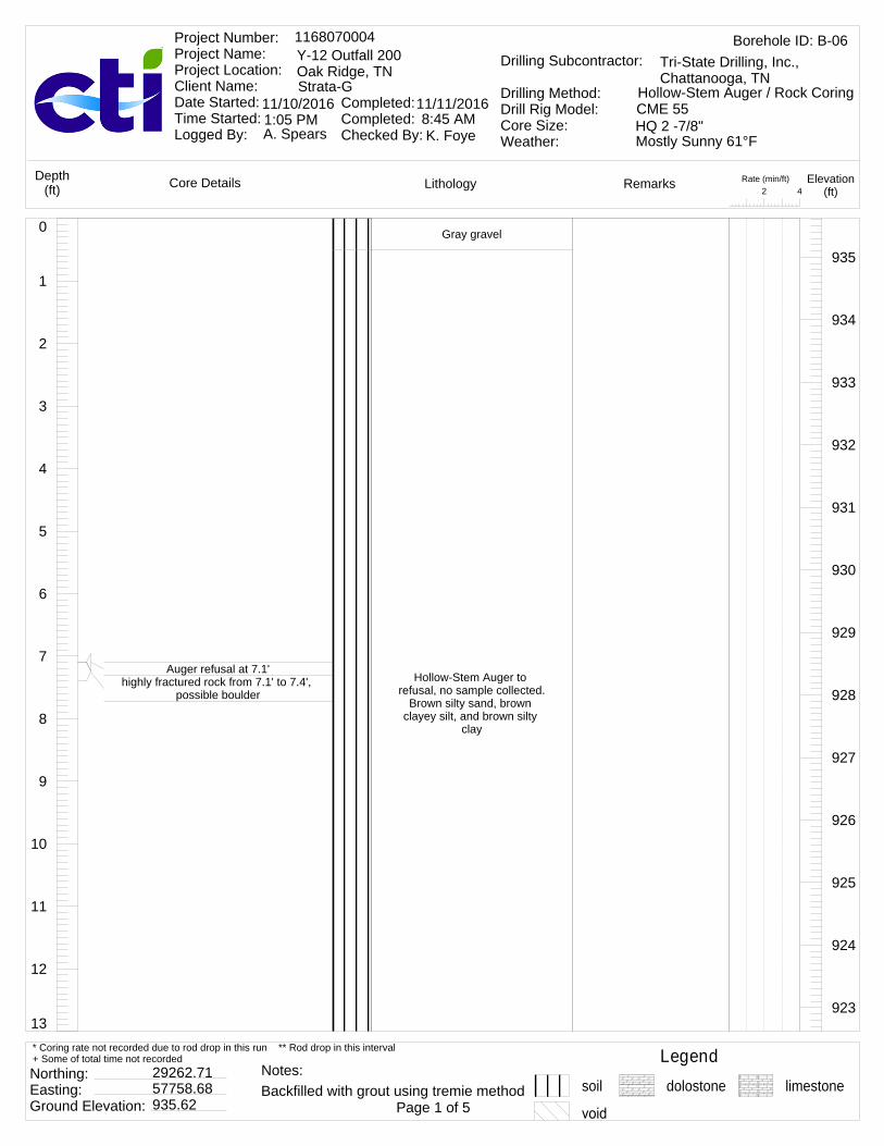
13
12
11
10
9
8
7
6
5
4
3
2
1
0 Gray gravel
Hollow-Stem Auger to refusal, no sample collected.
Brown silty sand, brown clayey silt, and brown silty
clay
935
934
933
932
931
930
929
928
927
926
925
924
923
Auger refusal at 7.1'highly fractured rock from 7.1' to 7.4',
possible boulder
Rate (min/ft)42
LithologyCore Details RemarksDepth(ft)
Elevation(ft)
Borehole ID: B-061168070004Y-12 Outfall 200Oak Ridge, TNStrata-G
Project Number: Project Name: Project Location: Client Name: Date Started: Time Started: Logged By:
Completed: Completed: Checked By:
11/10/2016 11/11/2016
A. Spears K. Foye
Drilling Subcontractor:
Drilling Method:Drill Rig Model:Core Size:Weather:
Tri-State Drilling, Inc., Chattanooga, TN
Hollow-Stem Auger / Rock CoringCME 55HQ 2 -7/8"1:05 PM 8:45 AMMostly Sunny 61°F
Legendsoil dolostone limestone
Northing: Easting: Ground Elevation:
29262.7157758.68935.62 Page 1 of 5
* Coring rate not recorded due to rod drop in this run ** Rod drop in this interval+ Some of total time not recorded
Backfilled with grout using tremie methodNotes:
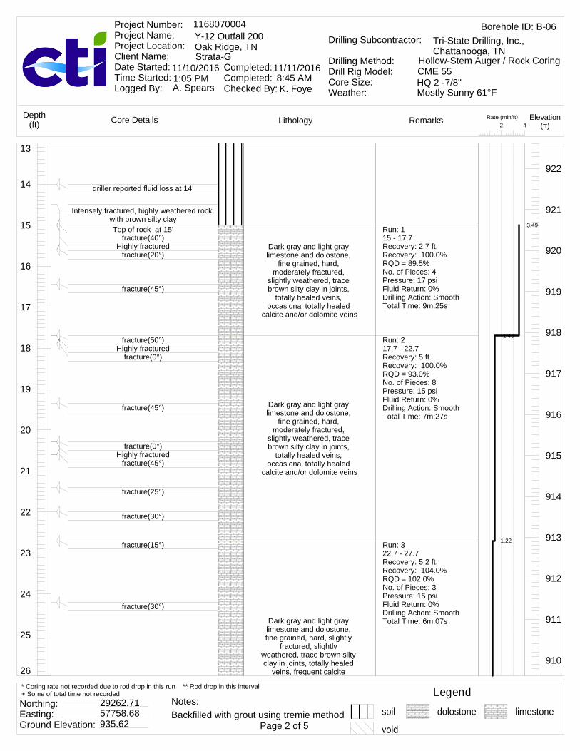
26
25
24
23
22
21
20
19
18
17
16
15
14
13
Dark gray and light gray limestone and dolostone,
fine grained, hard, moderately fractured,
slightly weathered, trace brown silty clay in joints,
totally healed veins, occasional totally healed
calcite and/or dolomite veins
Dark gray and light gray limestone and dolostone,
fine grained, hard, moderately fractured,
slightly weathered, trace brown silty clay in joints,
totally healed veins, occasional totally healed
calcite and/or dolomite veins
Dark gray and light gray limestone and dolostone, fine grained, hard, slightly
fractured, slightly weathered, trace brown silty clay in joints, totally healed
922
921
920
919
918
917
916
915
914
913
912
911
910
driller reported fluid loss at 14'
Intensely fractured, highly weathered rock with brown silty clayTop of rock at 15'
fracture(40°)Highly fractured
fracture(20°)
fracture(45°)
fracture(50°)Highly fractured
fracture(0°)
fracture(45°)
fracture(0°)Highly fractured
fracture(45°)
fracture(25°)
fracture(30°)
fracture(15°)
fracture(30°)
Run: 115 - 17.7Recovery: 2.7 ft.Recovery: 100.0%RQD = 89.5%No. of Pieces: 4Pressure: 17 psiFluid Return: 0%Drilling Action: SmoothTotal Time: 9m:25s
Run: 217.7 - 22.7Recovery: 5 ft.Recovery: 100.0%RQD = 93.0%No. of Pieces: 8Pressure: 15 psiFluid Return: 0%Drilling Action: SmoothTotal Time: 7m:27s
Run: 322.7 - 27.7Recovery: 5.2 ft.Recovery: 104.0%RQD = 102.0%No. of Pieces: 3Pressure: 15 psiFluid Return: 0%Drilling Action: SmoothTotal Time: 6m:07s
3.49
1.43
1.22
Rate (min/ft)42
LithologyCore Details RemarksDepth(ft)
Elevation(ft)
Borehole ID: B-061168070004Y-12 Outfall 200Oak Ridge, TNStrata-G
Project Number: Project Name: Project Location: Client Name: Date Started: Time Started: Logged By:
Completed: Completed: Checked By:
11/10/2016 11/11/2016
A. Spears K. Foye
Drilling Subcontractor:
Drilling Method:Drill Rig Model:Core Size:Weather:
Tri-State Drilling, Inc., Chattanooga, TN
Hollow-Stem Auger / Rock CoringCME 55HQ 2 -7/8"1:05 PM 8:45 AMMostly Sunny 61°F
Legendsoil dolostone limestone
Northing: Easting: Ground Elevation:
29262.7157758.68935.62 Page 2 of 5
* Coring rate not recorded due to rod drop in this run ** Rod drop in this interval+ Some of total time not recorded
Backfilled with grout using tremie methodNotes:

39
38
37
36
35
34
33
32
31
30
29
28
27
26 and/or dolomite veins
Dark gray and light gray limestone and dolostone,
fine grained, hard, slightly to moderately fractured,
slightly weathered, trace brown silty clay in joints,
totally healed veins, frequent calcite and/or
dolomite veins
Dark gray and light gray limestone and dolostone,
fine grained, hard, moderately fractured,
slightly weathered, some brown silty clay in joints,
totally healed veins, frequent calcite and/or
dolomite veins
Dark gray and light gray limestone and dolostone, fine grained, hard, highly
909
908
907
906
905
904
903
902
901
900
899
898
897
fracture(40°)
moderately fractured
fracture(35°)
fracture(35°)
fracture(30°)
fracture(0°)
Highly fractured at open jointfracture(35°)fracture(45°)
fracture(55°)
fracture(0°)
driller reported fluid loss at 38.6'
Run: 427.7 - 32.7Recovery: 5 ft.Recovery: 100.0%RQD = 95.0%No. of Pieces: 3Pressure: 15 psiFluid Return: 0%Drilling Action: SmoothTotal Time: 5m:47s
Run: 532.7 - 37.7Recovery: 5.15 ft.Recovery: 103.0%RQD = 101.0%No. of Pieces: 4Pressure: 15 psiFluid Return: 0%Drilling Action: SmoothTotal Time: 5m:46s
Run: 637.7 - 42.7Recovery: 2.5 ft.Recovery: 50.0%RQD = 45.0%
1.16
1.15
1.8
Rate (min/ft)42
LithologyCore Details RemarksDepth(ft)
Elevation(ft)
Borehole ID: B-061168070004Y-12 Outfall 200Oak Ridge, TNStrata-G
Project Number: Project Name: Project Location: Client Name: Date Started: Time Started: Logged By:
Completed: Completed: Checked By:
11/10/2016 11/11/2016
A. Spears K. Foye
Drilling Subcontractor:
Drilling Method:Drill Rig Model:Core Size:Weather:
Tri-State Drilling, Inc., Chattanooga, TN
Hollow-Stem Auger / Rock CoringCME 55HQ 2 -7/8"1:05 PM 8:45 AMMostly Sunny 61°F
Legendsoil dolostone limestone
Northing: Easting: Ground Elevation:
29262.7157758.68935.62 Page 3 of 5
* Coring rate not recorded due to rod drop in this run ** Rod drop in this interval+ Some of total time not recorded
Backfilled with grout using tremie methodNotes:
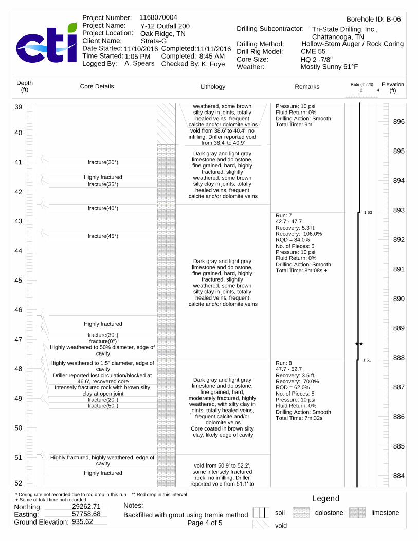
52
51
50
49
48
47
46
45
44
43
42
41
40
39 weathered, some brown silty clay in joints, totally healed veins, frequent
calcite and/or dolomite veinsvoid from 38.6' to 40.4', no
infilling. Driller reported void from 38.4' to 40.9'
Dark gray and light gray limestone and dolostone, fine grained, hard, highly
fractured, slightly weathered, some brown silty clay in joints, totally healed veins, frequent
calcite and/or dolomite veins
Dark gray and light gray limestone and dolostone, fine grained, hard, highly
fractured, slightly weathered, some brown silty clay in joints, totally healed veins, frequent
calcite and/or dolomite veins
Dark gray and light gray limestone and dolostone,
fine grained, hard, moderately fractured, highly weathered, with silty clay in joints, totally healed veins,
frequent calcite and/or dolomite veins
Core coated in brown silty clay, likely edge of cavity
void from 50.9' to 52.2', some intensely fractured rock, no infilling. Driller
896
895
894
893
892
891
890
889
888
887
886
885
884
fracture(20°)
Highly fracturedfracture(35°)
fracture(40°)
fracture(45°)
Highly fractured
fracture(30°)fracture(0°)
Highly weathered to 50% diameter, edge of cavity
Highly weathered to 1.5" diameter, edge of cavity
Driller reported lost circulation/blocked at 46.6', recovered core
Intensely fractured rock with brown silty clay at open joint
fracture(20°)fracture(50°)
Highly fractured, highly weathered, edge of cavity
Highly fractured
Pressure: 10 psiFluid Return: 0%Drilling Action: SmoothTotal Time: 9m
Run: 742.7 - 47.7Recovery: 5.3 ft.Recovery: 106.0%RQD = 84.0%No. of Pieces: 5Pressure: 10 psiFluid Return: 0%Drilling Action: SmoothTotal Time: 8m:08s +
Run: 847.7 - 52.7Recovery: 3.5 ft.Recovery: 70.0%RQD = 62.0%No. of Pieces: 5Pressure: 10 psiFluid Return: 0%Drilling Action: SmoothTotal Time: 7m:32s
1.63
1.51
**
Rate (min/ft)42
LithologyCore Details RemarksDepth(ft)
Elevation(ft)
Borehole ID: B-061168070004Y-12 Outfall 200Oak Ridge, TNStrata-G
Project Number: Project Name: Project Location: Client Name: Date Started: Time Started: Logged By:
Completed: Completed: Checked By:
11/10/2016 11/11/2016
A. Spears K. Foye
Drilling Subcontractor:
Drilling Method:Drill Rig Model:Core Size:Weather:
Tri-State Drilling, Inc., Chattanooga, TN
Hollow-Stem Auger / Rock CoringCME 55HQ 2 -7/8"1:05 PM 8:45 AMMostly Sunny 61°F
Legendsoil dolostone limestone
Northing: Easting: Ground Elevation:
29262.7157758.68935.62 Page 4 of 5
* Coring rate not recorded due to rod drop in this run ** Rod drop in this interval+ Some of total time not recorded
Backfilled with grout using tremie methodNotes:

60
59
58
57
56
55
54
53
52 52.3'
Dark gray and light gray limestone and dolostone,
fine grained, hard, moderately fractured,
moderately weathered, some brown silty clay and calcite and/or dolomite in
joints, totally healed veins, frequent calcite and/or
dolomite veinsCore coated in gray
void from 54.7' to 55.7', no infilling. Driller reported void at 55.7', likely lost core piece
void from 55.7' to 55.8', some intensely fractured
rock with grayish brown silty clay infilling
Dark gray and light gray limestone and dolostone,
fine grained, hard, moderately fractured,
moderately weathered, some brown silty clay in joints, frequently totally healed calcite and/or
dolomite veins, occasional moderately healed veins
with brown siltyvoid from 58' to 59.2', some intensely fractured rock with medium stiff grayish brown
silty clay infillingDark gray and light gray limestone and dolostone,
fine grained, hard, moderately fractured,
moderately weathered, some grayish brown silty clay in joints, frequently
totally healed calcite and/or dolomite veins
End of boring recovery at 60.2'
883
882
881
880
879
878
877
876
fracture(60°)
fracture(40°)
fracture(30°)
Highly weathered
fracture(30°)
fracture(20°)
fracture(50°)Driller reported lost circulation/blocked at
59.2', recovered core
Run: 952.7 - 55.7Recovery: 2 ft.Recovery: 66.7%RQD = 64.0%No. of Pieces: 2Pressure: 55 psiFluid Return: 0%Drilling Action: SmoothTotal Time: Not Recorded
Run: 10A55.7 - 59.2Recovery: 2.2 ft.Recovery: 62.9%RQD = 61.0%No. of Pieces: 2Pressure: 55 psiFluid Return: 0%Drilling Action: SmoothTotal Time: 9m:52s
Run: 10B59.2 - 60.2Recovery: 1.05 ft.Recovery: 105.0%RQD = 100.0%No. of Pieces: 1Pressure: 55 psiFluid Return: 0%Drilling Action: SmoothTotal Time: 2m:59s
1.03
2.82
2.98
*
**
Rate (min/ft)42
LithologyCore Details RemarksDepth(ft)
Elevation(ft)
Borehole ID: B-061168070004Y-12 Outfall 200Oak Ridge, TNStrata-G
Project Number: Project Name: Project Location: Client Name: Date Started: Time Started: Logged By:
Completed: Completed: Checked By:
11/10/2016 11/11/2016
A. Spears K. Foye
Drilling Subcontractor:
Drilling Method:Drill Rig Model:Core Size:Weather:
Tri-State Drilling, Inc., Chattanooga, TN
Hollow-Stem Auger / Rock CoringCME 55HQ 2 -7/8"1:05 PM 8:45 AMMostly Sunny 61°F
Legendsoil dolostone limestone
Northing: Easting: Ground Elevation:
29262.7157758.68935.62 Page 5 of 5
* Coring rate not recorded due to rod drop in this run ** Rod drop in this interval+ Some of total time not recorded
Backfilled with grout using tremie methodNotes:

after drillingafter drilling
13
12
11
10
9
8
7
6
5
4
3
2
1
0 Gray gravel
Hollow-Stem Auger to refusal, no sample
collected. Light brown fine grained
sand, brown coarse grained sand and silt, and brown
silty clay
936
935
934
933
932
931
930
929
928
927
926
925
924
923
Water level at 10.7' after drilling/before coring
Rate (min/ft)42
LithologyCore Details RemarksDepth(ft)
Elevation(ft)
Borehole ID: B-071168070004Y-12 Outfall 200Oak Ridge, TNStrata-G
Project Number: Project Name: Project Location: Client Name: Date Started: Time Started: Logged By:
Completed: Completed: Checked By:
11/3/2016 11/4/2016
A. Spears K. Foye
Drilling Subcontractor:
Drilling Method:Drill Rig Model:Core Size:Weather:
Tri-State Drilling, Inc., Chattanooga, TN
Hollow-Stem Auger / Rock CoringCME 55HQ 2 -7/8"2:02 PM 10:30 AMSunny 61°F
Legendsoil dolostone limestone
Northing: Easting: Ground Elevation:
29234.857760.81936 Page 1 of 5
* Coring rate not recorded due to rod drop in this run ** Rod drop in this interval+ Some of total time not recorded
Backfilled with grout using tremie methodNotes:

26
25
24
23
22
21
20
19
18
17
16
15
14
13
Light gray and dark gray limestone, fine grained,
hard, moderately fractured, slightly weathered, totally
healed veins
Light gray and dark gray limestone, fine grained,
hard, moderately fractured, slightly weathered, totally
healed veins
Light gray and dark gray limestone, fine grained,
hard, moderately fractured, slightly weathered, totally
healed veins
923
922
921
920
919
918
917
916
915
914
913
912
911
910
Water level at 17' during drilling
Auger refusal/Top of rock at 17.8'fracture(20°)
fracture(60°)
fracture(0°)fracture(0°)
fracture(50°)Driller reported lost circulation/blocked at
20.8', recovered core
fracture(55°)
fracture(45°)
fracture(35°)
fracture(50°)
Run: 117.8 - 20.8Recovery: 2.85 ft.Recovery: 95.0%RQD = 31.0%No. of Pieces: 4Pressure: 45 psiFluid Return: 100%Drilling Action: SmoothTotal Time: 9m:01s
Run: 220.8 - 22.7Recovery: 1.9 ft.Recovery: 100.0%RQD = 94.0%No. of Pieces: 2Pressure: 45 psiFluid Return: 100%Drilling Action: SmoothTotal Time: 3m:23sRun: 322.7 - 27.7Recovery: 5 ft.Recovery: 100.0%RQD = 97.0%No. of Pieces: 5Pressure: 25 psiFluid Return: 100%Drilling Action: SmoothTotal Time: 5m:48s
3.01
1.78
1.16
Rate (min/ft)42
LithologyCore Details RemarksDepth(ft)
Elevation(ft)
Borehole ID: B-071168070004Y-12 Outfall 200Oak Ridge, TNStrata-G
Project Number: Project Name: Project Location: Client Name: Date Started: Time Started: Logged By:
Completed: Completed: Checked By:
11/3/2016 11/4/2016
A. Spears K. Foye
Drilling Subcontractor:
Drilling Method:Drill Rig Model:Core Size:Weather:
Tri-State Drilling, Inc., Chattanooga, TN
Hollow-Stem Auger / Rock CoringCME 55HQ 2 -7/8"2:02 PM 10:30 AMSunny 61°F
Legendsoil dolostone limestone
Northing: Easting: Ground Elevation:
29234.857760.81936 Page 2 of 5
* Coring rate not recorded due to rod drop in this run ** Rod drop in this interval+ Some of total time not recorded
Backfilled with grout using tremie methodNotes:

39
38
37
36
35
34
33
32
31
30
29
28
27
26
Light gray and dark gray limestone, fine grained,
hard, moderately fractured, slightly weathered, trace
brown sand and silt in joints, totally healed veins
void from 32.6' to 34.9', no infilling. Driller reported void
from 32.5' to 40.5'
Light gray and dark gray limestone, fine grained, highly fractured, hard,
slightly weathered, trace brown sand and silt in joints,
totally healed veinsLikely edge of cavity
void from 35.6' to 37.7', no infilling
910
909
908
907
906
905
904
903
902
901
900
899
898
897
fracture(0°)fracture(15°)
fracture(0°)
fracture(50°)
fracture(35°)
fracture(10°)fracture(45°)
driller reported fluid loss at 32.6'
driller reported fluid loss at 35.6'
Run: 427.7 - 32.7Recovery: 5 ft.Recovery: 100.0%RQD = 88.0%No. of Pieces: 4Pressure: 25 psiFluid Return: 100%Drilling Action: SmoothTotal Time: 6m:05s
Run: 532.7 - 37.7Recovery: 0.7 ft.Recovery: 14.0%RQD = 0.0%No. of Pieces: 4Pressure: 0 psiFluid Return: 20%Drilling Action: SmoothTotal Time: Not Recorded
Run: 637.7 - 42.7Recovery: 2.2 ft.Recovery: 44.0%RQD = 40.0%
1.22
*
*
Rate (min/ft)42
LithologyCore Details RemarksDepth(ft)
Elevation(ft)
Borehole ID: B-071168070004Y-12 Outfall 200Oak Ridge, TNStrata-G
Project Number: Project Name: Project Location: Client Name: Date Started: Time Started: Logged By:
Completed: Completed: Checked By:
11/3/2016 11/4/2016
A. Spears K. Foye
Drilling Subcontractor:
Drilling Method:Drill Rig Model:Core Size:Weather:
Tri-State Drilling, Inc., Chattanooga, TN
Hollow-Stem Auger / Rock CoringCME 55HQ 2 -7/8"2:02 PM 10:30 AMSunny 61°F
Legendsoil dolostone limestone
Northing: Easting: Ground Elevation:
29234.857760.81936 Page 3 of 5
* Coring rate not recorded due to rod drop in this run ** Rod drop in this interval+ Some of total time not recorded
Backfilled with grout using tremie methodNotes:
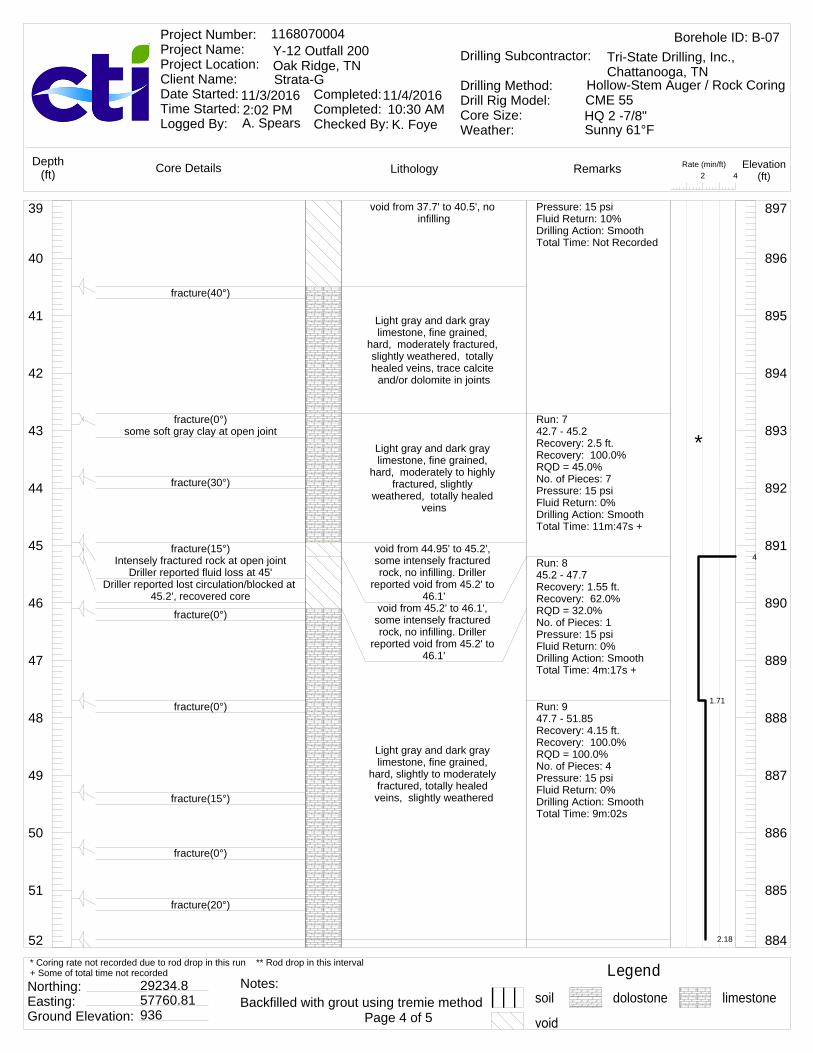
52
51
50
49
48
47
46
45
44
43
42
41
40
39 void from 37.7' to 40.5', no infilling
Light gray and dark gray limestone, fine grained,
hard, moderately fractured, slightly weathered, totally healed veins, trace calcite
and/or dolomite in joints
Light gray and dark gray limestone, fine grained,
hard, moderately to highly fractured, slightly
weathered, totally healed veins
void from 44.95' to 45.2', some intensely fractured rock, no infilling. Driller
reported void from 45.2' to 46.1'
void from 45.2' to 46.1', some intensely fractured rock, no infilling. Driller
reported void from 45.2' to 46.1'
Light gray and dark gray limestone, fine grained,
hard, slightly to moderately fractured, totally healed veins, slightly weathered
897
896
895
894
893
892
891
890
889
888
887
886
885
884
fracture(40°)
fracture(0°)some soft gray clay at open joint
fracture(30°)
fracture(15°)Intensely fractured rock at open joint
Driller reported fluid loss at 45'Driller reported lost circulation/blocked at
45.2', recovered core
fracture(0°)
fracture(0°)
fracture(15°)
fracture(0°)
fracture(20°)
Pressure: 15 psiFluid Return: 10%Drilling Action: SmoothTotal Time: Not Recorded
Run: 742.7 - 45.2Recovery: 2.5 ft.Recovery: 100.0%RQD = 45.0%No. of Pieces: 7Pressure: 15 psiFluid Return: 0%Drilling Action: SmoothTotal Time: 11m:47s +
Run: 845.2 - 47.7Recovery: 1.55 ft.Recovery: 62.0%RQD = 32.0%No. of Pieces: 1Pressure: 15 psiFluid Return: 0%Drilling Action: SmoothTotal Time: 4m:17s +
Run: 947.7 - 51.85Recovery: 4.15 ft.Recovery: 100.0%RQD = 100.0%No. of Pieces: 4Pressure: 15 psiFluid Return: 0%Drilling Action: SmoothTotal Time: 9m:02s
4
1.71
2.18
*
Rate (min/ft)42
LithologyCore Details RemarksDepth(ft)
Elevation(ft)
Borehole ID: B-071168070004Y-12 Outfall 200Oak Ridge, TNStrata-G
Project Number: Project Name: Project Location: Client Name: Date Started: Time Started: Logged By:
Completed: Completed: Checked By:
11/3/2016 11/4/2016
A. Spears K. Foye
Drilling Subcontractor:
Drilling Method:Drill Rig Model:Core Size:Weather:
Tri-State Drilling, Inc., Chattanooga, TN
Hollow-Stem Auger / Rock CoringCME 55HQ 2 -7/8"2:02 PM 10:30 AMSunny 61°F
Legendsoil dolostone limestone
Northing: Easting: Ground Elevation:
29234.857760.81936 Page 4 of 5
* Coring rate not recorded due to rod drop in this run ** Rod drop in this interval+ Some of total time not recorded
Backfilled with grout using tremie methodNotes:

60
59
58
57
56
55
54
53
52 Light gray and dark gray limestone, fine grained,
hard, slightly to moderately fractured, totally healed veins, slightly weathered
Light gray and dark gray limestone and dolostone,
fine grained, hard, slightly to moderately fractured,
slightly weathered, totally healed veins
Light gray and dark gray limestone and dolostone,
fine grained, hard, moderately fractured,
slightly weathered, moderately healed veins
with trace brown silt in jointsvoid from 59.1' to 60.8',
some soft gray clay infilling. Driller reported void from
59.1' to 62.7'
884
883
882
881
880
879
878
877
876
fracture(10°)
fracture(25°)
fracture(15°)
fracture(20°)
fracture(0°)fracture(10°)
fracture (angle not provided, >0°)
fracture (angle not provided, >0°)Driller reported fluid loss at 59.1'
Run: 1051.85 - 52.7Recovery: 0.85 ft.Recovery: 100.0%RQD = 0.0%No. of Pieces: 1Pressure: 0 psiFluid Return: 0%Drilling Action: SmoothTotal Time: Not RecordedRun: 1152.7 - 57.7Recovery: 5 ft.Recovery: 100.0%RQD = 0.0%No. of Pieces: 4Pressure: 15 psiFluid Return: 0%Drilling Action: SmoothTotal Time: 5m:22s
Run: 1257.7 - 62.7Recovery: 2.35 ft.Recovery: 47.0%RQD = 91.0%No. of Pieces: 3Pressure: 15 psiFluid Return: 0%Drilling Action: SmoothTotal Time: 1m:41s+
1.07
0.337
*
Rate (min/ft)42
LithologyCore Details RemarksDepth(ft)
Elevation(ft)
Borehole ID: B-071168070004Y-12 Outfall 200Oak Ridge, TNStrata-G
Project Number: Project Name: Project Location: Client Name: Date Started: Time Started: Logged By:
Completed: Completed: Checked By:
11/3/2016 11/4/2016
A. Spears K. Foye
Drilling Subcontractor:
Drilling Method:Drill Rig Model:Core Size:Weather:
Tri-State Drilling, Inc., Chattanooga, TN
Hollow-Stem Auger / Rock CoringCME 55HQ 2 -7/8"2:02 PM 10:30 AMSunny 61°F
Legendsoil dolostone limestone
Northing: Easting: Ground Elevation:
29234.857760.81936 Page 5 of 5
* Coring rate not recorded due to rod drop in this run ** Rod drop in this interval+ Some of total time not recorded
Backfilled with grout using tremie methodNotes:

13
12
11
10
9
8
7
6
5
4
3
2
1
0 Gray gravel
Hollow-Stem Auger to refusal, no sample
collected. brown silty clay
935
934
933
932
931
930
929
928
927
926
925
924
923
Rate (min/ft)42
LithologyCore Details RemarksDepth(ft)
Elevation(ft)
Borehole ID: B-081168070004Y-12 Outfall 200Oak Ridge, TNStrata-G
Project Number: Project Name: Project Location: Client Name: Date Started: Time Started: Logged By:
Completed: Completed: Checked By:
11/18/2016 11/19/2016
A. Spears K. Foye
Drilling Subcontractor:
Drilling Method:Drill Rig Model:Core Size:Weather:
Tri-State Drilling, Inc., Chattanooga, TN
Hollow-Stem Auger / Rock CoringCME 55HQ 2 -7/8"2:50 PM 8:54 AMSunny 73°F
Legendsoil dolostone limestone
Northing: Easting: Ground Elevation:
29268.1457781.86935.13 Page 1 of 5
* Coring rate not recorded due to rod drop in this run ** Rod drop in this interval+ Some of total time not recorded
Backfilled with grout using tremie methodNotes:

26
25
24
23
22
21
20
19
18
17
16
15
14
13
Light gray and dark gray limestone; fine grained,
hard, highly fractured, highly weathered, totally healed
veins, frequent totally healed calcite and/or
dolomite veins with brown silty clay infilling in joints
Light gray dolostone, fine grained, moderately to
highly fractured, moderately weathered, occasional
styolite totally healed veins, some calcite, styolite, and
brown silty clay in joint
922
921
920
919
918
917
916
915
914
913
912
911
910
fracture(50°)Top of rock 18.8'
Auger refusal at 19'fracture(40°)
fracture(55°)
fracture(0°)Intensely fractured
fracture(0°)
fracture(45°)Intensely fractured rock at open joint
fracture(65°)Intensely fractured rock at open joint
fracture(60°)fracture(40°)
fracture(40°)
Run: 118.8 - 20.8Recovery: 2.7 ft.Recovery: 135.0%RQD = 71.0%No. of Pieces: 3Pressure: 30 psiFluid Return: 100%Drilling Action: SmoothTotal Time: 5mRun: 220.8 - 25.8Recovery: 4.7 ft.Recovery: 94.0%RQD = 86.0%No. of Pieces: 6Pressure: 76 psiFluid Return: 100%Drilling Action: SmoothTotal Time: 17m
2.5
3.4
1.8
Rate (min/ft)42
LithologyCore Details RemarksDepth(ft)
Elevation(ft)
Borehole ID: B-081168070004Y-12 Outfall 200Oak Ridge, TNStrata-G
Project Number: Project Name: Project Location: Client Name: Date Started: Time Started: Logged By:
Completed: Completed: Checked By:
11/18/2016 11/19/2016
A. Spears K. Foye
Drilling Subcontractor:
Drilling Method:Drill Rig Model:Core Size:Weather:
Tri-State Drilling, Inc., Chattanooga, TN
Hollow-Stem Auger / Rock CoringCME 55HQ 2 -7/8"2:50 PM 8:54 AMSunny 73°F
Legendsoil dolostone limestone
Northing: Easting: Ground Elevation:
29268.1457781.86935.13 Page 2 of 5
* Coring rate not recorded due to rod drop in this run ** Rod drop in this interval+ Some of total time not recorded
Backfilled with grout using tremie methodNotes:

39
38
37
36
35
34
33
32
31
30
29
28
27
26
Dark gray and light gray limestone and dolostone, fine grained, hard, highly
fractured, moderately weathered, frequently totally
healed veins with brown silty clay infilling
void from 30.4' to 30.8', no infilling. Driller reported void
from 30.6' to 30.8'
Dark gray and light gray limestone and dolostone,
fine grained, hard, moderately to highly fractured, moderately
weathered, frequently totally healed styolite veins,
occasional calcite and/or dolomite seams, trace brown silty clay in joints
Dark gray and light gray limestone and dolostone, fine grained, hard, highly
fractured, moderately weathered, frequently totally
healed styolite veins, occasional calcite and/or
dolomite seams, trace brown silty clay in joints
909
908
907
906
905
904
903
902
901
900
899
898
897
fracture(35°)
fracture(20°)
fracture(15°)
fracture(50°)driller reported fluid loss at 30.6'
fracture(15°)
fracture(20°)
fracture(45°)fracture(45°)fracture(0°)
fracture(50°)
fracture(25°)
fracture(0°)fracture(30°)fracture(60°)
moderately fractured
fracture(15°)
moderately fractured
fracture(45°)
Run: 325.8 - 30.8Recovery: 5.1 ft.Recovery: 102.0%RQD = 96.0%No. of Pieces: 5Pressure: 76 psiFluid Return: 100%Drilling Action: SmoothTotal Time: 9m
Run: 430.8 - 35.8Recovery: 4.6 ft.Recovery: 92.0%RQD = 85.0%No. of Pieces: 10Pressure: 60 psiFluid Return: 90%On run #4, return drilling fluid was clean, despite drilling mud being used for drilling.Drilling Action: SmoothTotal Time: 11m
Run: 535.8 - 40.8Recovery: 4.9 ft.Recovery: 98.0%RQD = 82.0%No. of Pieces: 2Pressure: 42 psiFluid Return: 90%Drilling Action: SmoothTotal Time: 10m
2.2
2
Rate (min/ft)42
LithologyCore Details RemarksDepth(ft)
Elevation(ft)
Borehole ID: B-081168070004Y-12 Outfall 200Oak Ridge, TNStrata-G
Project Number: Project Name: Project Location: Client Name: Date Started: Time Started: Logged By:
Completed: Completed: Checked By:
11/18/2016 11/19/2016
A. Spears K. Foye
Drilling Subcontractor:
Drilling Method:Drill Rig Model:Core Size:Weather:
Tri-State Drilling, Inc., Chattanooga, TN
Hollow-Stem Auger / Rock CoringCME 55HQ 2 -7/8"2:50 PM 8:54 AMSunny 73°F
Legendsoil dolostone limestone
Northing: Easting: Ground Elevation:
29268.1457781.86935.13 Page 3 of 5
* Coring rate not recorded due to rod drop in this run ** Rod drop in this interval+ Some of total time not recorded
Backfilled with grout using tremie methodNotes:

52
51
50
49
48
47
46
45
44
43
42
41
40
39
Dark gray and light gray limestone and dolostone,
fine grained, hard, moderately fractured,
moderately weathered, frequently totally healed styolite veins, occasional calcite and/or dolomite
seams, trace brown silty clay in joints
Dark gray and light gray limestone and dolostone,
fine grained, hard, moderately fractured,
moderately weathered, frequently totally healed styolite veins, occasional calcite and/or dolomite
seams, trace brown silty clay in joints
End of boring recovery a
896
895
894
893
892
891
890
889
888
887
886
885
884
fracture(40°)
fracture(45°)
fracture(0°)Highly fractured
fracture(0°)
Run: 640.8 - 45.8Recovery: 5.3 ft.Recovery: 106.0%RQD = 104.0%No. of Pieces: 2Pressure: 20 psiFluid Return: 90%Drilling Action: SmoothTotal Time: 7m
Run: 745.8 - 50.8Recovery: 5 ft.Recovery: 100.0%RQD = 100.0%No. of Pieces: 3Pressure: 20 psiFluid Return: 90%Drilling Action: SmoothTotal Time: 7m
1.4
1.4
Rate (min/ft)42
LithologyCore Details RemarksDepth(ft)
Elevation(ft)
Borehole ID: B-081168070004Y-12 Outfall 200Oak Ridge, TNStrata-G
Project Number: Project Name: Project Location: Client Name: Date Started: Time Started: Logged By:
Completed: Completed: Checked By:
11/18/2016 11/19/2016
A. Spears K. Foye
Drilling Subcontractor:
Drilling Method:Drill Rig Model:Core Size:Weather:
Tri-State Drilling, Inc., Chattanooga, TN
Hollow-Stem Auger / Rock CoringCME 55HQ 2 -7/8"2:50 PM 8:54 AMSunny 73°F
Legendsoil dolostone limestone
Northing: Easting: Ground Elevation:
29268.1457781.86935.13 Page 4 of 5
* Coring rate not recorded due to rod drop in this run ** Rod drop in this interval+ Some of total time not recorded
Backfilled with grout using tremie methodNotes:
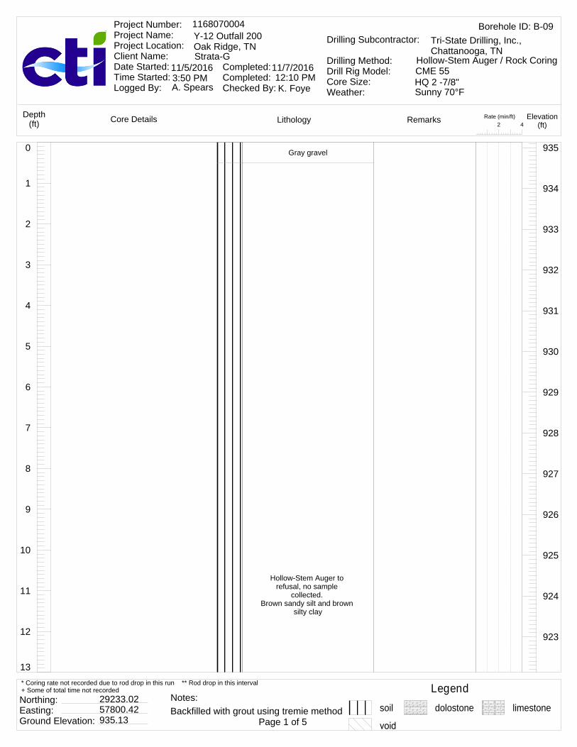
13
12
11
10
9
8
7
6
5
4
3
2
1
0 Gray gravel
Hollow-Stem Auger to refusal, no sample
collected. Brown sandy silt and brown
silty clay
935
934
933
932
931
930
929
928
927
926
925
924
923
Rate (min/ft)42
LithologyCore Details RemarksDepth(ft)
Elevation(ft)
Borehole ID: B-091168070004Y-12 Outfall 200Oak Ridge, TNStrata-G
Project Number: Project Name: Project Location: Client Name: Date Started: Time Started: Logged By:
Completed: Completed: Checked By:
11/5/2016 11/7/2016
A. Spears K. Foye
Drilling Subcontractor:
Drilling Method:Drill Rig Model:Core Size:Weather:
Tri-State Drilling, Inc., Chattanooga, TN
Hollow-Stem Auger / Rock CoringCME 55HQ 2 -7/8"3:50 PM 12:10 PMSunny 70°F
Legendsoil dolostone limestone
Northing: Easting: Ground Elevation:
29233.0257800.42935.13 Page 1 of 5
* Coring rate not recorded due to rod drop in this run ** Rod drop in this interval+ Some of total time not recorded
Backfilled with grout using tremie methodNotes:

26
25
24
23
22
21
20
19
18
17
16
15
14
13
Void from 21.7' to 24.6', no infilling. Driller reported likely edge of cavity with
brown silty clay infilling from overburden, due
encountering rock at 21.7'
Light gray and dark gray
922
921
920
919
918
917
916
915
914
913
912
911
910
Auger refusal at 22'
Top of rock at 24.6'fracture(40°)
fracture(20°)
Run: 124.6 - 27.8Recovery: 3.2 ft.Recovery: 100.0%RQD = 50.0%
3.13
Rate (min/ft)42
LithologyCore Details RemarksDepth(ft)
Elevation(ft)
Borehole ID: B-091168070004Y-12 Outfall 200Oak Ridge, TNStrata-G
Project Number: Project Name: Project Location: Client Name: Date Started: Time Started: Logged By:
Completed: Completed: Checked By:
11/5/2016 11/7/2016
A. Spears K. Foye
Drilling Subcontractor:
Drilling Method:Drill Rig Model:Core Size:Weather:
Tri-State Drilling, Inc., Chattanooga, TN
Hollow-Stem Auger / Rock CoringCME 55HQ 2 -7/8"3:50 PM 12:10 PMSunny 70°F
Legendsoil dolostone limestone
Northing: Easting: Ground Elevation:
29233.0257800.42935.13 Page 2 of 5
* Coring rate not recorded due to rod drop in this run ** Rod drop in this interval+ Some of total time not recorded
Backfilled with grout using tremie methodNotes:
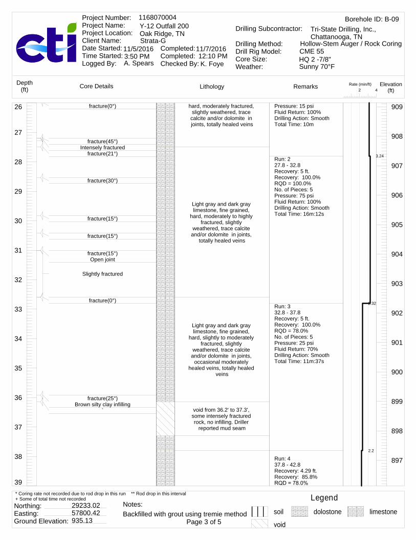
39
38
37
36
35
34
33
32
31
30
29
28
27
26 hard, moderately fractured, slightly weathered, trace
calcite and/or dolomite in joints, totally healed veins
Light gray and dark gray limestone, fine grained,
hard, moderately to highly fractured, slightly
weathered, trace calcite and/or dolomite in joints,
totally healed veins
Light gray and dark gray limestone, fine grained,
hard, slightly to moderately fractured, slightly
weathered, trace calcite and/or dolomite in joints,
occasional moderately healed veins, totally healed
veins
void from 36.2' to 37.3', some intensely fractured rock, no infilling. Driller
reported mud seam
909
908
907
906
905
904
903
902
901
900
899
898
897
fracture(0°)
fracture(45°)Intensely fractured
fracture(21°)
fracture(30°)
fracture(15°)
fracture(15°)
fracture(15°)Open joint
Slightly fractured
fracture(0°)
fracture(25°)Brown silty clay infilling
`
Pressure: 15 psiFluid Return: 100%Drilling Action: SmoothTotal Time: 10m
Run: 227.8 - 32.8Recovery: 5 ft.Recovery: 100.0%RQD = 100.0%No. of Pieces: 5Pressure: 75 psiFluid Return: 100%Drilling Action: SmoothTotal Time: 16m:12s
Run: 332.8 - 37.8Recovery: 5 ft.Recovery: 100.0%RQD = 78.0%No. of Pieces: 5Pressure: 25 psiFluid Return: 70%Drilling Action: SmoothTotal Time: 11m:37s
Run: 437.8 - 42.8Recovery: 4.29 ft.Recovery: 85.8%
3.24
2.32
2.2
Rate (min/ft)42
LithologyCore Details RemarksDepth(ft)
Elevation(ft)
Borehole ID: B-091168070004Y-12 Outfall 200Oak Ridge, TNStrata-G
Project Number: Project Name: Project Location: Client Name: Date Started: Time Started: Logged By:
Completed: Completed: Checked By:
11/5/2016 11/7/2016
A. Spears K. Foye
Drilling Subcontractor:
Drilling Method:Drill Rig Model:Core Size:Weather:
Tri-State Drilling, Inc., Chattanooga, TN
Hollow-Stem Auger / Rock CoringCME 55HQ 2 -7/8"3:50 PM 12:10 PMSunny 70°F
Legendsoil dolostone limestone
Northing: Easting: Ground Elevation:
29233.0257800.42935.13 Page 3 of 5
* Coring rate not recorded due to rod drop in this run ** Rod drop in this interval+ Some of total time not recorded
Backfilled with grout using tremie methodNotes:
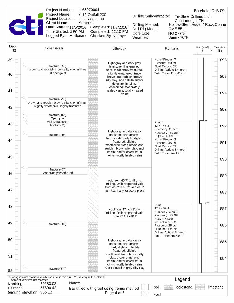
52
51
50
49
48
47
46
45
44
43
42
41
40
39Light gray and dark gray limestone, fine grained,
hard, moderately fractured, slightly weathered, trace brown and reddish brown
silty clay, and calcite and/or dolomite in joints,
occasional moderately healed veins, totally healed
veins
Light gray and dark gray limestone, fine grained,
hard, moderately to slightly fractured, slightly
weathered, trace brown and reddish brown silty clay, and
calcite and/or dolomite in joints, totally healed veins
void from 45.7' to 47', no infilling. Driller reported void from 45.7' to 46.2', and 46.6' to 47.2', likely lost core piece
void from 47' to 49', no infilling. Driller reported void
from 47.2' to 48.7'
Light gray and dark gray limestone, fine grained, hard, slightly to highly
fractured, slightly weathered, trace brown silty
clay, brown sand, and calcite and/or dolomite in joints, totally healed veins
Core coated in gray silty clay
896
895
894
893
892
891
890
889
888
887
886
885
884
fracture(65°)brown and reddish brown silty clay infilling
at open joint
fracture(75°)brown and reddish brown, silty clay infilling,
slightly weathered, highly fractured
fracture(15°)Open joint
Highly fracturedfracture(0°)
fracture(45°)
fracture(0°)Moderately weathered
fracture(30°)
fracture(37°)
No. of Pieces: 7Pressure: 50 psiFluid Return: 0%Drilling Action: SmoothTotal Time: 11m:01s +
Run: 542.8 - 47.8Recovery: 2.95 ft.Recovery: 59.0%RQD = 58.0%No. of Pieces: 2Pressure: 45 psiFluid Return: 0%Drilling Action: SmoothTotal Time: 7m:15s +
Run: 647.8 - 52.8Recovery: 3.85 ft.Recovery: 77.0%RQD = 74.0%No. of Pieces: 3Pressure: 25 psiFluid Return: 0%Drilling Action: SmoothTotal Time: 8m:54s +
1.45
1.78
Rate (min/ft)42
LithologyCore Details RemarksDepth(ft)
Elevation(ft)
Borehole ID: B-091168070004Y-12 Outfall 200Oak Ridge, TNStrata-G
Project Number: Project Name: Project Location: Client Name: Date Started: Time Started: Logged By:
Completed: Completed: Checked By:
11/5/2016 11/7/2016
A. Spears K. Foye
Drilling Subcontractor:
Drilling Method:Drill Rig Model:Core Size:Weather:
Tri-State Drilling, Inc., Chattanooga, TN
Hollow-Stem Auger / Rock CoringCME 55HQ 2 -7/8"3:50 PM 12:10 PMSunny 70°F
Legendsoil dolostone limestone
Northing: Easting: Ground Elevation:
29233.0257800.42935.13 Page 4 of 5
* Coring rate not recorded due to rod drop in this run ** Rod drop in this interval+ Some of total time not recorded
Backfilled with grout using tremie methodNotes:

60
59
58
57
56
55
54
53
52
Light gray and dark gray limestone, fine grained, hard, highly fractured, moderately weathered,
trace brown silty clay, brown sand, and calcite and/or dolomite in joints, totally
healed veins
void from 55.9' to 57.4', no infilling
Light gray and dark gray limestone, fine grained, hard, highly fractured,
slightly weathered, trace brown silty clay, brown
sand, calcite and/or dolomite in joints, totally
healed veins End of boring recovery at
60.1'
883
882
881
880
879
878
877
876
fracture(0°)
fracture(0°)
fracture(50°)
fracture(20°)
fracture(37°)Driller reported lost circulation/blocked at
55.8', recovered corefracture(0°)fracture(0°)
fracture(0°)
Intensely fracturedfracture(55°)fracture(20°)Open joint
Run: 752.8 - 57.8Recovery: 5 ft.Recovery: 100.0%RQD = 52.0%No. of Pieces: 6Pressure: 45 psiFluid Return: 0%Drilling Action: SmoothTotal Time: 6m:18s +
Run: 857.8 - 60.2Recovery: 2.3 ft.Recovery: 95.8%RQD = 82.0%No. of Pieces: 2Pressure: 25 psiFluid Return: 0%Drilling Action: SmoothTotal Time: 25m
1.26
4
**
Rate (min/ft)42
LithologyCore Details RemarksDepth(ft)
Elevation(ft)
Borehole ID: B-091168070004Y-12 Outfall 200Oak Ridge, TNStrata-G
Project Number: Project Name: Project Location: Client Name: Date Started: Time Started: Logged By:
Completed: Completed: Checked By:
11/5/2016 11/7/2016
A. Spears K. Foye
Drilling Subcontractor:
Drilling Method:Drill Rig Model:Core Size:Weather:
Tri-State Drilling, Inc., Chattanooga, TN
Hollow-Stem Auger / Rock CoringCME 55HQ 2 -7/8"3:50 PM 12:10 PMSunny 70°F
Legendsoil dolostone limestone
Northing: Easting: Ground Elevation:
29233.0257800.42935.13 Page 5 of 5
* Coring rate not recorded due to rod drop in this run ** Rod drop in this interval+ Some of total time not recorded
Backfilled with grout using tremie methodNotes:

13
12
11
10
9
8
7
6
5
4
3
2
1
0 Gray gravel
Hollow-Stem Auger to refusal, no sample
collected. Brown sandy silt and brown
silty clay
935
934
933
932
931
930
929
928
927
926
925
924
923
Rate (min/ft)42
LithologyCore Details RemarksDepth(ft)
Elevation(ft)
Borehole ID: B-101168070004Y-12 Outfall 200Oak Ridge, TNStrata-G
Project Number: Project Name: Project Location: Client Name: Date Started: Time Started: Logged By:
Completed: Completed: Checked By:
11/5/2016 11/5/2016
A. Spears K. Foye
Drilling Subcontractor:
Drilling Method:Drill Rig Model:Core Size:Weather:
Tri-State Drilling, Inc., Chattanooga, TN
Hollow-Stem Auger / Rock CoringCME 55HQ 2 -7/8"8:00 AM 2:30 PMSunny 45°F
Legendsoil dolostone limestone
Northing: Easting: Ground Elevation:
29244.0257820.75935.62 Page 1 of 5
* Coring rate not recorded due to rod drop in this run ** Rod drop in this interval+ Some of total time not recorded
Backfilled with grout using tremie methodNotes:
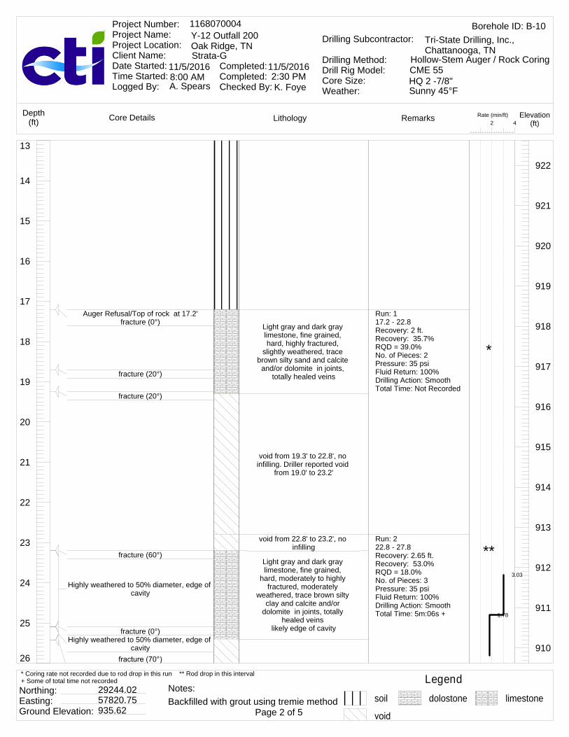
26
25
24
23
22
21
20
19
18
17
16
15
14
13
Light gray and dark gray limestone, fine grained, hard, highly fractured,
slightly weathered, trace brown silty sand and calcite and/or dolomite in joints,
totally healed veins
void from 19.3' to 22.8', no infilling. Driller reported void
from 19.0' to 23.2'
void from 22.8' to 23.2', no infilling
Light gray and dark gray limestone, fine grained,
hard, moderately to highly fractured, moderately
weathered, trace brown silty clay and calcite and/or
dolomite in joints, totally healed veins
likely edge of cavity
922
921
920
919
918
917
916
915
914
913
912
911
910
Auger Refusal/Top of rock at 17.2'fracture (0°)
fracture (20°)
fracture (20°)
fracture (60°)
Highly weathered to 50% diameter, edge of cavity
fracture (0°)Highly weathered to 50% diameter, edge of
cavity
Run: 117.2 - 22.8Recovery: 2 ft.Recovery: 35.7%RQD = 39.0%No. of Pieces: 2Pressure: 35 psiFluid Return: 100%Drilling Action: SmoothTotal Time: Not Recorded
Run: 222.8 - 27.8Recovery: 2.65 ft.Recovery: 53.0%RQD = 18.0%No. of Pieces: 3Pressure: 35 psiFluid Return: 100%Drilling Action: SmoothTotal Time: 5m:06s +
3.03
1.78
*
**
Rate (min/ft)42
LithologyCore Details RemarksDepth(ft)
Elevation(ft)
Borehole ID: B-101168070004Y-12 Outfall 200Oak Ridge, TNStrata-G
Project Number: Project Name: Project Location: Client Name: Date Started: Time Started: Logged By:
Completed: Completed: Checked By:
11/5/2016 11/5/2016
A. Spears K. Foye
Drilling Subcontractor:
Drilling Method:Drill Rig Model:Core Size:Weather:
Tri-State Drilling, Inc., Chattanooga, TN
Hollow-Stem Auger / Rock CoringCME 55HQ 2 -7/8"8:00 AM 2:30 PMSunny 45°F
Legendsoil dolostone limestone
Northing: Easting: Ground Elevation:
29244.0257820.75935.62 Page 2 of 5
* Coring rate not recorded due to rod drop in this run ** Rod drop in this interval+ Some of total time not recorded
Backfilled with grout using tremie methodNotes:

39
38
37
36
35
34
33
32
31
30
29
28
27
26 void from 25.4' to 27.5', soft brown silty clay infilling with
intensely fractured rock. Driller reported void from
25.4' to 26.3', 27.4' to 27.7'
Light gray and dark gray limestone, fine grained, hard, highly fractured, moderately weathered,
trace brown silty clay and calcite and/or dolomite in joints, totally healed veins
likely edge of cavityvoid from 28.2' to 29.9', no
infilling. Driller reported void from 28.2' to 29.8'
Light gray and dark gray limestone, fine grained, hard, slightly fractured, moderately weathered,
trace brown silty clay and calcite and/or dolomite in joints, totally healed veins
void from 35.8' to 36.1', no infilling. Driller reported void
from 35.8' to 36.1'
void from 37' to 37.8', some soft brown silty clay infilling with highly fractured rock. Driller reported void from
37.1' to 39.1'void from 37.8' to 39.1',
some soft brown silty clay infilling with highly fractured
rock
909
908
907
906
905
904
903
902
901
900
899
898
897
soft brown silty clay infilling with intensely fractured rock in open joint
fracture(70°)
fracture (70°)
fracture(35°)
Slightly fractured
fracture (0°)
trace brown silty clay staining in fracturefracture (35°)
Highly fractured
fracture(45°)
Run: 327.8 - 32.8Recovery: 3.3 ft.Recovery: 66.0%RQD = 97.0%No. of Pieces: 3Pressure: 27 psiFluid Return: 100%Drilling Action: SmoothTotal Time: 13m:02s
Run: 432.8 - 37.8Recovery: 3 ft.Recovery: 60.0%RQD = 77.0%No. of Pieces: 2Pressure: 25 psiFluid Return: 100%Drilling Action: SmoothTotal Time: 1m:58s +
Run: 537.8 - 42.8Recovery: 3.7 ft.Recovery: 74.0%
3.3
2.63
3.95
2.45
2.2
1.77
1.12
0.85
**
*
*
**
Rate (min/ft)42
LithologyCore Details RemarksDepth(ft)
Elevation(ft)
Borehole ID: B-101168070004Y-12 Outfall 200Oak Ridge, TNStrata-G
Project Number: Project Name: Project Location: Client Name: Date Started: Time Started: Logged By:
Completed: Completed: Checked By:
11/5/2016 11/5/2016
A. Spears K. Foye
Drilling Subcontractor:
Drilling Method:Drill Rig Model:Core Size:Weather:
Tri-State Drilling, Inc., Chattanooga, TN
Hollow-Stem Auger / Rock CoringCME 55HQ 2 -7/8"8:00 AM 2:30 PMSunny 45°F
Legendsoil dolostone limestone
Northing: Easting: Ground Elevation:
29244.0257820.75935.62 Page 3 of 5
* Coring rate not recorded due to rod drop in this run ** Rod drop in this interval+ Some of total time not recorded
Backfilled with grout using tremie methodNotes:

52
51
50
49
48
47
46
45
44
43
42
41
40
39
Light gray and dark gray limestone, fine grained, hard, slightly fractured, moderately weathered,
trace brown silty clay and calcite and/or dolomite in joints, totally healed veins
Light gray and dark gray limestone, fine grained,
hard, moderately to slightly fractured, moderately
weathered, trace brown silty clay and calcite and/or
dolomite in joints, totally healed veins
Light gray and dark gray limestone, fine grained,
hard, slightly to moderately fractured, moderately
weathered, trace brown silty clay and calcite and/or
dolomite in joints, totally healed veins
896
895
894
893
892
891
890
889
888
887
886
885
884
fracture(45°)soft brown silty clay infilling with highly
fractured rock at open joint
fracture (0°)
fracture (30°)trace brown silt in fracture
Driller reported fluid loss at 48.7' at highly weathered section from 48.7 ' to 48.8'
fracture(35°)
fracture(40°)
fracture(40°)
No. of Pieces: 4Pressure: 25 psiFluid Return: 100%Drilling Action: SmoothTotal Time: 4m:06s +
Run: 642.8 - 47.8Recovery: 5 ft.Recovery: 100.0%RQD = 100.0%No. of Pieces: 2Pressure: 25 psiFluid Return: 100%Drilling Action: SmoothTotal Time: 6m:36s +
Run: 747.8 - 52.8Recovery: 5 ft.Recovery: 100.0%RQD = 87.0%No. of Pieces: 7Pressure: 25 psiFluid Return: 0%Drilling Action: SmoothTotal Time: 6m:36s +
1.4
1.37
1.3
1.75
1.52
1.72
1.57
1.67
1.05
1.6
1.02
1.22
Rate (min/ft)42
LithologyCore Details RemarksDepth(ft)
Elevation(ft)
Borehole ID: B-101168070004Y-12 Outfall 200Oak Ridge, TNStrata-G
Project Number: Project Name: Project Location: Client Name: Date Started: Time Started: Logged By:
Completed: Completed: Checked By:
11/5/2016 11/5/2016
A. Spears K. Foye
Drilling Subcontractor:
Drilling Method:Drill Rig Model:Core Size:Weather:
Tri-State Drilling, Inc., Chattanooga, TN
Hollow-Stem Auger / Rock CoringCME 55HQ 2 -7/8"8:00 AM 2:30 PMSunny 45°F
Legendsoil dolostone limestone
Northing: Easting: Ground Elevation:
29244.0257820.75935.62 Page 4 of 5
* Coring rate not recorded due to rod drop in this run ** Rod drop in this interval+ Some of total time not recorded
Backfilled with grout using tremie methodNotes:

60
59
58
57
56
55
54
53
52
Light gray and dark gray limestone, fine grained,
hard, moderately to highly fractured, moderately
weathered, trace brown silty clay and calcite and/or
dolomite in joints, totally healed veins
Light gray and dark gray limestone, fine grained,
hard, moderately fractured, moderately weathered,
trace gray clay and calcite and/or dolomite in joints,
totally healed veinsLight gray and dark gray limestone, fine grained, hard, highly fractured, moderately weathered,
trace gray clay and calcite and/or dolomite in joints,
totally healed veinsvoid from 58.45' to 58.55',
some gray clay infilling with intensely fractured rock
End of boring recovery at 60'
883
882
881
880
879
878
877
876
fracture(0°)fracture(70°)
Moderately weathered rock with trace brown silt at open joint
fracture(0°)
fracture(45°)Highly fractured rock
fracture (55°)Driller reported lost circulation/blocked at
55.8', recovered core
fracture (45°)
fracture (55°)
fracture (45°)Intensely fractured rock with gray clay
infillingfracture (45°)fracture (40°)
Open jointfracture (45°)
fracture (0°)
Run: 852.8 - 55.8Recovery: 3 ft.Recovery: 100.0%RQD = 72.0%No. of Pieces: 10+Pressure: 25 psiFluid Return: 50%Drilling Action: SmoothTotal Time: Not Recorded
Run: 955.8 - 57.8Recovery: 1.5 ft.Recovery: 75.0%RQD = 75.0%No. of Pieces: 2Pressure: 25 psiFluid Return: 0%Drilling Action: SmoothTotal Time: Not RecordedRun: 1057.8 - 60Recovery: 2.1 ft.Recovery: 95.5%RQD = 96.0%No. of Pieces: 8Pressure: 25 psiFluid Return: 0%Drilling Action: SmoothTotal Time: Not Recorded
*
*
*
Rate (min/ft)42
LithologyCore Details RemarksDepth(ft)
Elevation(ft)
Borehole ID: B-101168070004Y-12 Outfall 200Oak Ridge, TNStrata-G
Project Number: Project Name: Project Location: Client Name: Date Started: Time Started: Logged By:
Completed: Completed: Checked By:
11/5/2016 11/5/2016
A. Spears K. Foye
Drilling Subcontractor:
Drilling Method:Drill Rig Model:Core Size:Weather:
Tri-State Drilling, Inc., Chattanooga, TN
Hollow-Stem Auger / Rock CoringCME 55HQ 2 -7/8"8:00 AM 2:30 PMSunny 45°F
Legendsoil dolostone limestone
Northing: Easting: Ground Elevation:
29244.0257820.75935.62 Page 5 of 5
* Coring rate not recorded due to rod drop in this run ** Rod drop in this interval+ Some of total time not recorded
Backfilled with grout using tremie methodNotes:

13
12
11
10
9
8
7
6
5
4
3
2
1
0 Gray gravel
Hollow-Stem Auger to refusal, no sample
collected. Brown sandy silt, brown
clayey silt, and brown silty clay
935
934
933
932
931
930
929
928
927
926
925
924
923
Rate (min/ft)42
LithologyCore Details RemarksDepth(ft)
Elevation(ft)
Borehole ID: B-111168070004Y-12 Outfall 200Oak Ridge, TNStrata-G
Project Number: Project Name: Project Location: Client Name: Date Started: Time Started: Logged By:
Completed: Completed: Checked By:
11/4/2016 11/4/2016
A. Spears K. Foye
Drilling Subcontractor:
Drilling Method:Drill Rig Model:Core Size:Weather:
Tri-State Drilling, Inc., Chattanooga, TN
Hollow-Stem Auger / Rock CoringCME 55HQ 2 -7/8"10:55 AM 4:40 PMSunny 64°F
Legendsoil dolostone limestone
Northing: Easting: Ground Elevation:
29253.2757837.22935.67 Page 1 of 5
* Coring rate not recorded due to rod drop in this run ** Rod drop in this interval+ Some of total time not recorded
Backfilled with grout using tremie methodNotes:

after drillingafter drilling
26
25
24
23
22
21
20
19
18
17
16
15
14
13
void from 20.9' to 21.93', some brown clayey silt infilling with intensely
fractured rock
Light gray and dark gray limestone, fine grained, hard to moderately hard,
highly fractured, moderately weathered, trace brown silt and calcite and/or dolomite
in joints, totally healed veins, occasional
moderately healed veins
Light gray and dark gray limestone, fine grained,
hard, moderately fractured, slightly weathered, trace
brown silt and calcite and/or
922
921
920
919
918
917
916
915
914
913
912
911
910
Auger refusal at 20.9'
Top of rock 21.9'fracture(30°)
Some brown clayey silt infilling with intensely fractured rock at open joint
fracture(15°)Some brown silt infilling at open joint
fracture(0°)
fracture(25°)
fracture(25°)
Run: 120.9 - 22.8Recovery: 1.4 ft.Recovery: 73.7%RQD = 49.0%No. of Pieces: 10+Pressure: 15 psiFluid Return: 100%Drilling Action: SmoothTotal Time: Not RecordedRun: 222.8 - 27.8Recovery: 5 ft.Recovery: 100.0%RQD = 100.0%No. of Pieces: 10+Pressure: 75 psiFluid Return: 100%Drilling Action: SmoothTotal Time: 9m:45s
1.95
*
Rate (min/ft)42
LithologyCore Details RemarksDepth(ft)
Elevation(ft)
Borehole ID: B-111168070004Y-12 Outfall 200Oak Ridge, TNStrata-G
Project Number: Project Name: Project Location: Client Name: Date Started: Time Started: Logged By:
Completed: Completed: Checked By:
11/4/2016 11/4/2016
A. Spears K. Foye
Drilling Subcontractor:
Drilling Method:Drill Rig Model:Core Size:Weather:
Tri-State Drilling, Inc., Chattanooga, TN
Hollow-Stem Auger / Rock CoringCME 55HQ 2 -7/8"10:55 AM 4:40 PMSunny 64°F
Legendsoil dolostone limestone
Northing: Easting: Ground Elevation:
29253.2757837.22935.67 Page 2 of 5
* Coring rate not recorded due to rod drop in this run ** Rod drop in this interval+ Some of total time not recorded
Backfilled with grout using tremie methodNotes:
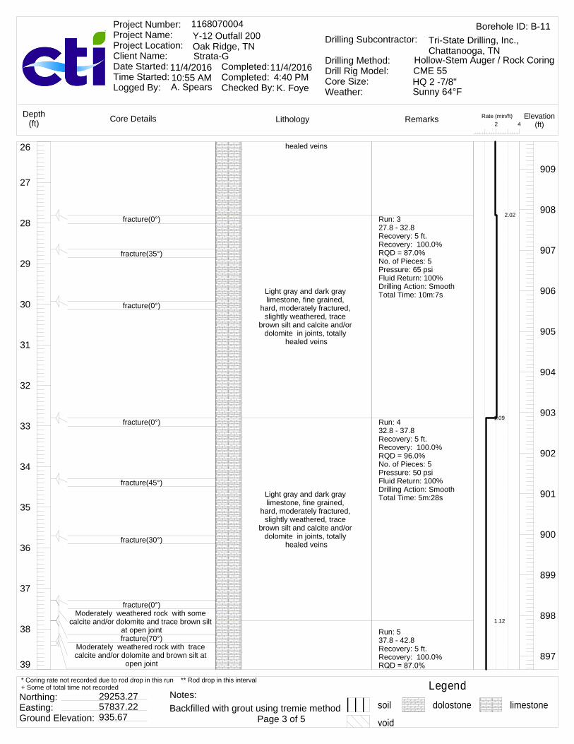
39
38
37
36
35
34
33
32
31
30
29
28
27
26 healed veins
Light gray and dark gray limestone, fine grained,
hard, moderately fractured, slightly weathered, trace
brown silt and calcite and/or dolomite in joints, totally
healed veins
Light gray and dark gray limestone, fine grained,
hard, moderately fractured, slightly weathered, trace
brown silt and calcite and/or dolomite in joints, totally
healed veins
909
908
907
906
905
904
903
902
901
900
899
898
897
fracture(0°)
fracture(35°)
fracture(0°)
fracture(0°)
fracture(45°)
fracture(30°)
fracture(0°)Moderately weathered rock with some
calcite and/or dolomite and trace brown silt at open jointfracture(70°)
Moderately weathered rock with trace calcite and/or dolomite and brown silt at
open joint
Run: 327.8 - 32.8Recovery: 5 ft.Recovery: 100.0%RQD = 87.0%No. of Pieces: 5Pressure: 65 psiFluid Return: 100%Drilling Action: SmoothTotal Time: 10m:7s
Run: 432.8 - 37.8Recovery: 5 ft.Recovery: 100.0%RQD = 96.0%No. of Pieces: 5Pressure: 50 psiFluid Return: 100%Drilling Action: SmoothTotal Time: 5m:28s
Run: 537.8 - 42.8Recovery: 5 ft.Recovery: 100.0%
2.02
1.09
1.12
Rate (min/ft)42
LithologyCore Details RemarksDepth(ft)
Elevation(ft)
Borehole ID: B-111168070004Y-12 Outfall 200Oak Ridge, TNStrata-G
Project Number: Project Name: Project Location: Client Name: Date Started: Time Started: Logged By:
Completed: Completed: Checked By:
11/4/2016 11/4/2016
A. Spears K. Foye
Drilling Subcontractor:
Drilling Method:Drill Rig Model:Core Size:Weather:
Tri-State Drilling, Inc., Chattanooga, TN
Hollow-Stem Auger / Rock CoringCME 55HQ 2 -7/8"10:55 AM 4:40 PMSunny 64°F
Legendsoil dolostone limestone
Northing: Easting: Ground Elevation:
29253.2757837.22935.67 Page 3 of 5
* Coring rate not recorded due to rod drop in this run ** Rod drop in this interval+ Some of total time not recorded
Backfilled with grout using tremie methodNotes:
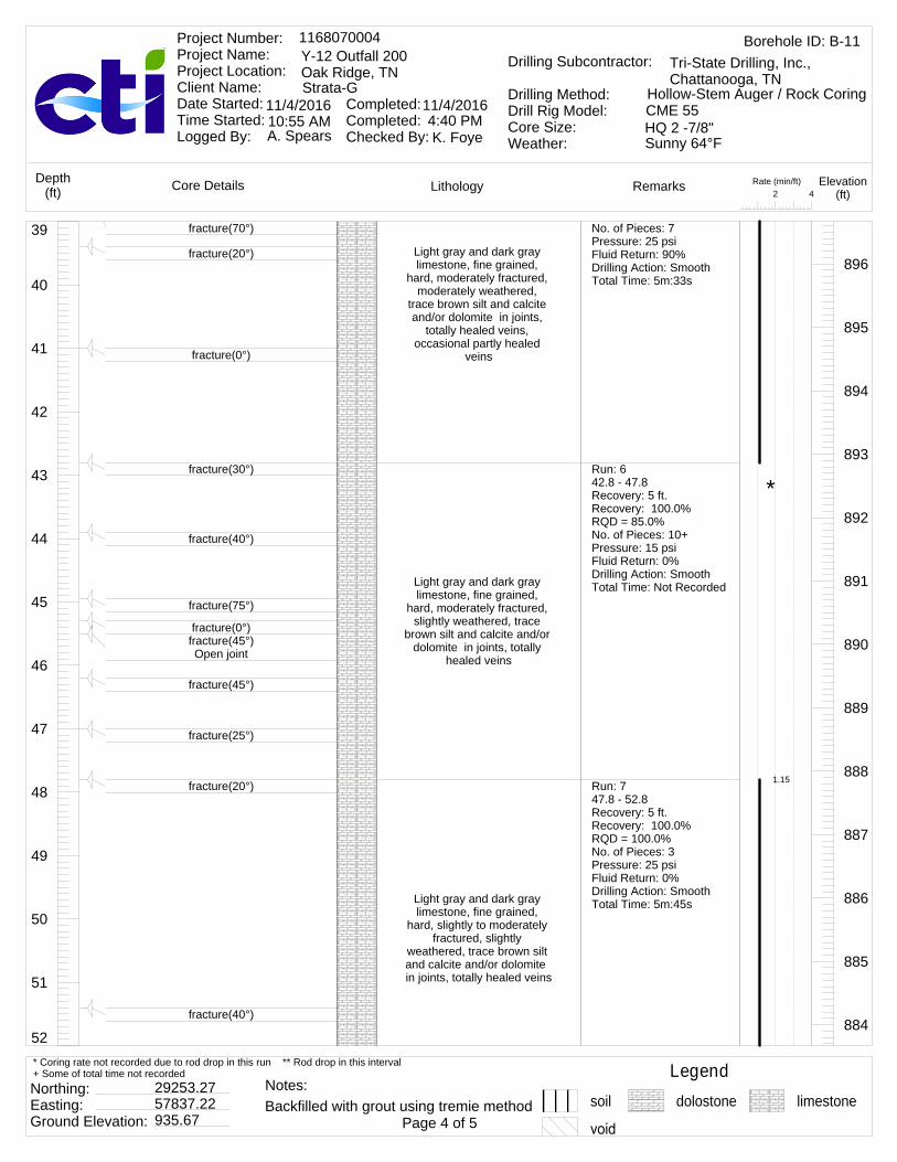
52
51
50
49
48
47
46
45
44
43
42
41
40
39Light gray and dark gray limestone, fine grained,
hard, moderately fractured, moderately weathered,
trace brown silt and calcite and/or dolomite in joints,
totally healed veins, occasional partly healed
veins
Light gray and dark gray limestone, fine grained,
hard, moderately fractured, slightly weathered, trace
brown silt and calcite and/or dolomite in joints, totally
healed veins
Light gray and dark gray limestone, fine grained,
hard, slightly to moderately fractured, slightly
weathered, trace brown silt and calcite and/or dolomite in joints, totally healed veins
896
895
894
893
892
891
890
889
888
887
886
885
884
fracture(70°)
fracture(20°)
fracture(0°)
fracture(30°)
fracture(40°)
fracture(75°)
fracture(0°)fracture(45°)Open joint
fracture(45°)
fracture(25°)
fracture(20°)
fracture(40°)
No. of Pieces: 7Pressure: 25 psiFluid Return: 90%Drilling Action: SmoothTotal Time: 5m:33s
Run: 642.8 - 47.8Recovery: 5 ft.Recovery: 100.0%RQD = 85.0%No. of Pieces: 10+Pressure: 15 psiFluid Return: 0%Drilling Action: SmoothTotal Time: Not Recorded
Run: 747.8 - 52.8Recovery: 5 ft.Recovery: 100.0%RQD = 100.0%No. of Pieces: 3Pressure: 25 psiFluid Return: 0%Drilling Action: SmoothTotal Time: 5m:45s
1.15
*
Rate (min/ft)42
LithologyCore Details RemarksDepth(ft)
Elevation(ft)
Borehole ID: B-111168070004Y-12 Outfall 200Oak Ridge, TNStrata-G
Project Number: Project Name: Project Location: Client Name: Date Started: Time Started: Logged By:
Completed: Completed: Checked By:
11/4/2016 11/4/2016
A. Spears K. Foye
Drilling Subcontractor:
Drilling Method:Drill Rig Model:Core Size:Weather:
Tri-State Drilling, Inc., Chattanooga, TN
Hollow-Stem Auger / Rock CoringCME 55HQ 2 -7/8"10:55 AM 4:40 PMSunny 64°F
Legendsoil dolostone limestone
Northing: Easting: Ground Elevation:
29253.2757837.22935.67 Page 4 of 5
* Coring rate not recorded due to rod drop in this run ** Rod drop in this interval+ Some of total time not recorded
Backfilled with grout using tremie methodNotes:

60
59
58
57
56
55
54
53
52
Light gray and dark gray limestone, fine grained, hard, slightly to highly
fractured, slightly weathered, trace brown silt and calcite and/or dolomite in joints, totally healed veins
Light gray and dark gray limestone, fine grained,
hard, highly to moderately fractured, slightly
weathered, trace brown silt and calcite and/or dolomite in joints, totally healed veinsEnd of boring recovery at
60.3'
883
882
881
880
879
878
877
876
fracture(30°)
fracture(0°)
fracture(55°)Some brown sand infilling
fracture(45°)
Slightly fractured
fracture(0°)fracture(0°)
fracture(30°) Open joint
fracture(0°)
Run: 852.8 - 57.8Recovery: 5 ft.Recovery: 100.0%RQD = 93.0%No. of Pieces: 4Pressure: 25 psiFluid Return: 0%Drilling Action: SmoothTotal Time: 4m:49s
Run: 957.8 - 60.3Recovery: 2.63 ft.Recovery: 105.2%RQD = 95.0%No. of Pieces: 3Pressure: 65 psiFluid Return: 75%Drilling Action: SmoothTotal Time: Not Recorded
0.963
*
Rate (min/ft)42
LithologyCore Details RemarksDepth(ft)
Elevation(ft)
Borehole ID: B-111168070004Y-12 Outfall 200Oak Ridge, TNStrata-G
Project Number: Project Name: Project Location: Client Name: Date Started: Time Started: Logged By:
Completed: Completed: Checked By:
11/4/2016 11/4/2016
A. Spears K. Foye
Drilling Subcontractor:
Drilling Method:Drill Rig Model:Core Size:Weather:
Tri-State Drilling, Inc., Chattanooga, TN
Hollow-Stem Auger / Rock CoringCME 55HQ 2 -7/8"10:55 AM 4:40 PMSunny 64°F
Legendsoil dolostone limestone
Northing: Easting: Ground Elevation:
29253.2757837.22935.67 Page 5 of 5
* Coring rate not recorded due to rod drop in this run ** Rod drop in this interval+ Some of total time not recorded
Backfilled with grout using tremie methodNotes:
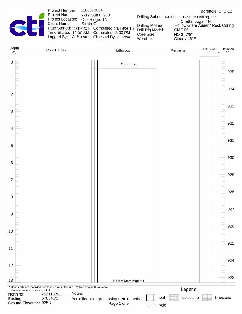
13
12
11
10
9
8
7
6
5
4
3
2
1
0 Gray gravel
935
934
933
932
931
930
929
928
927
926
925
924
923
Rate (min/ft)42
LithologyCore Details RemarksDepth(ft)
Elevation(ft)
Borehole ID: B-121168070004Y-12 Outfall 200Oak Ridge, TNStrata-G
Project Number: Project Name: Project Location: Client Name: Date Started: Time Started: Logged By:
Completed: Completed: Checked By:
11/19/2016 11/19/2016
A. Spears K. Foye
Drilling Subcontractor:
Drilling Method:Drill Rig Model:Core Size:Weather:
Tri-State Drilling, Inc., Chattanooga, TN
Hollow-Stem Auger / Rock CoringCME 55HQ 2 -7/8"10:30 AM 3:00 PMCloudy 45°F
Legendsoil dolostone limestone
Northing: Easting: Ground Elevation:
29211.7957854.71935.7 Page 1 of 5
* Coring rate not recorded due to rod drop in this run ** Rod drop in this interval+ Some of total time not recorded
Backfilled with grout using tremie methodNotes:

26
25
24
23
22
21
20
19
18
17
16
15
14
13 refusal, no sample collected.
Brown sandy silt, brown clayey silt, and brown silty
clay922
921
920
919
918
917
916
915
914
913
912
911
910
Rate (min/ft)42
LithologyCore Details RemarksDepth(ft)
Elevation(ft)
Borehole ID: B-121168070004Y-12 Outfall 200Oak Ridge, TNStrata-G
Project Number: Project Name: Project Location: Client Name: Date Started: Time Started: Logged By:
Completed: Completed: Checked By:
11/19/2016 11/19/2016
A. Spears K. Foye
Drilling Subcontractor:
Drilling Method:Drill Rig Model:Core Size:Weather:
Tri-State Drilling, Inc., Chattanooga, TN
Hollow-Stem Auger / Rock CoringCME 55HQ 2 -7/8"10:30 AM 3:00 PMCloudy 45°F
Legendsoil dolostone limestone
Northing: Easting: Ground Elevation:
29211.7957854.71935.7 Page 2 of 5
* Coring rate not recorded due to rod drop in this run ** Rod drop in this interval+ Some of total time not recorded
Backfilled with grout using tremie methodNotes:
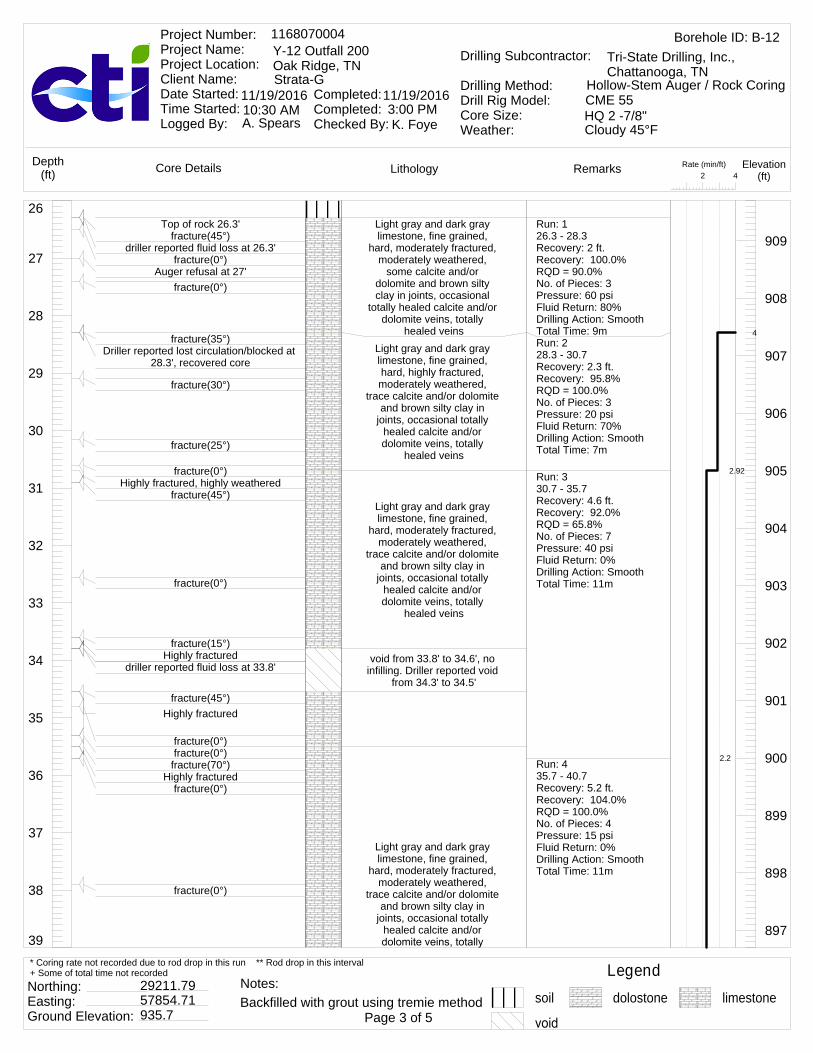
39
38
37
36
35
34
33
32
31
30
29
28
27
26Light gray and dark gray limestone, fine grained,
hard, moderately fractured, moderately weathered,
some calcite and/or dolomite and brown silty clay in joints, occasional
totally healed calcite and/or dolomite veins, totally
healed veinsLight gray and dark gray limestone, fine grained, hard, highly fractured, moderately weathered,
trace calcite and/or dolomite and brown silty clay in
joints, occasional totally healed calcite and/or dolomite veins, totally
healed veins
Light gray and dark gray limestone, fine grained,
hard, moderately fractured, moderately weathered,
trace calcite and/or dolomite and brown silty clay in
joints, occasional totally healed calcite and/or dolomite veins, totally
healed veins
void from 33.8' to 34.6', no infilling. Driller reported void
from 34.3' to 34.5'
Light gray and dark gray limestone, fine grained,
hard, moderately fractured, moderately weathered,
trace calcite and/or dolomite and brown silty clay in
joints, occasional totally healed calcite and/or
909
908
907
906
905
904
903
902
901
900
899
898
897
Top of rock 26.3'fracture(45°)
driller reported fluid loss at 26.3'fracture(0°)
Auger refusal at 27'fracture(0°)
fracture(35°)Driller reported lost circulation/blocked at
28.3', recovered core
fracture(30°)
fracture(25°)
fracture(0°)Highly fractured, highly weathered
fracture(45°)
fracture(0°)
fracture(15°)Highly fractured
driller reported fluid loss at 33.8'
fracture(45°)Highly fractured
fracture(0°)fracture(0°)
fracture(70°)Highly fractured
fracture(0°)
fracture(0°)
Run: 126.3 - 28.3Recovery: 2 ft.Recovery: 100.0%RQD = 90.0%No. of Pieces: 3Pressure: 60 psiFluid Return: 80%Drilling Action: SmoothTotal Time: 9mRun: 228.3 - 30.7Recovery: 2.3 ft.Recovery: 95.8%RQD = 100.0%No. of Pieces: 3Pressure: 20 psiFluid Return: 70%Drilling Action: SmoothTotal Time: 7m
Run: 330.7 - 35.7Recovery: 4.6 ft.Recovery: 92.0%RQD = 65.8%No. of Pieces: 7Pressure: 40 psiFluid Return: 0%Drilling Action: SmoothTotal Time: 11m
Run: 435.7 - 40.7Recovery: 5.2 ft.Recovery: 104.0%RQD = 100.0%No. of Pieces: 4Pressure: 15 psiFluid Return: 0%Drilling Action: SmoothTotal Time: 11m
4
2.92
2.2
Rate (min/ft)42
LithologyCore Details RemarksDepth(ft)
Elevation(ft)
Borehole ID: B-121168070004Y-12 Outfall 200Oak Ridge, TNStrata-G
Project Number: Project Name: Project Location: Client Name: Date Started: Time Started: Logged By:
Completed: Completed: Checked By:
11/19/2016 11/19/2016
A. Spears K. Foye
Drilling Subcontractor:
Drilling Method:Drill Rig Model:Core Size:Weather:
Tri-State Drilling, Inc., Chattanooga, TN
Hollow-Stem Auger / Rock CoringCME 55HQ 2 -7/8"10:30 AM 3:00 PMCloudy 45°F
Legendsoil dolostone limestone
Northing: Easting: Ground Elevation:
29211.7957854.71935.7 Page 3 of 5
* Coring rate not recorded due to rod drop in this run ** Rod drop in this interval+ Some of total time not recorded
Backfilled with grout using tremie methodNotes:

52
51
50
49
48
47
46
45
44
43
42
41
40
39 healed veins
Light gray and dark gray limestone, fine grained,
hard, moderately fractured, highly weathered, frequent moderately healed veins
with brown silty clay, occasional totally healed calcite and/or dolomite
veins, totally healed veins
Light gray and dark gray limestone, fine grained,
hard, moderately fractured, highly weathered, trace brown silty clay in joints,
some calcite and/or dolomite in joints
896
895
894
893
892
891
890
889
888
887
886
885
884
fracture(20°)Highly fractured
fracture(30°)
fracture(40°)
fracture(0°)
fracture(30°)Highly fractured, highly weathered
fracture(0°)
highly weathered from 1" to 2.87" diameter, edge of cavity
fracture(35°)fracture(60°)
fracture(30°)
fracture(0°)Highly fractured
fracture(40°)
Run: 540.7 - 45.7Recovery: 5 ft.Recovery: 100.0%RQD = 94.0%No. of Pieces: 5Pressure: 15 psiFluid Return: 0%Drilling Action: SmoothTotal Time: 7m:52s
Run: 645.7 - 50.7Recovery: 5 ft.Recovery: 100.0%RQD = 92.0%No. of Pieces: 4Pressure: 15 psiFluid Return: 0%Drilling Action: SmoothTotal Time: 7m
Run: 750.7 - 55.7Recovery: 5 ft.Recovery: 100.0%RQD = 85.0%
2.2
1.57
1.4
Rate (min/ft)42
LithologyCore Details RemarksDepth(ft)
Elevation(ft)
Borehole ID: B-121168070004Y-12 Outfall 200Oak Ridge, TNStrata-G
Project Number: Project Name: Project Location: Client Name: Date Started: Time Started: Logged By:
Completed: Completed: Checked By:
11/19/2016 11/19/2016
A. Spears K. Foye
Drilling Subcontractor:
Drilling Method:Drill Rig Model:Core Size:Weather:
Tri-State Drilling, Inc., Chattanooga, TN
Hollow-Stem Auger / Rock CoringCME 55HQ 2 -7/8"10:30 AM 3:00 PMCloudy 45°F
Legendsoil dolostone limestone
Northing: Easting: Ground Elevation:
29211.7957854.71935.7 Page 4 of 5
* Coring rate not recorded due to rod drop in this run ** Rod drop in this interval+ Some of total time not recorded
Backfilled with grout using tremie methodNotes:

60
59
58
57
56
55
54
53
52Light gray and dark gray limestone, fine grained,
hard, moderately to highly fractured, highly weathered,
frequent totally healed calcite and/or dolomite
veins, trace brown silty clay in joints, some calcite
and/or dolomite in joints
Light gray and dark gray limestone, fine grained,
hard, moderately fractured, highly weathered, frequent totally healed calcite and/or dolomite veins, trace brown
silty clay in joints, some calcite and/or dolomite in
jointsEnd of boring recovery at
60.7'
883
882
881
880
879
878
877
876
fracture(30°)
fracture(30°)
fracture(20°)fracture(30°)
fracture(40°)
fracture(25°)fracture(40°)
fracture(0°)
fracture(25°)
fracture(15°)
fracture(30°)
fracture(35°)
Pressure: 20 psiFluid Return: 0%Drilling Action: SmoothTotal Time: 7m
Run: 855.7 - 60.7Recovery: 5 ft.Recovery: 100.0%RQD = 100.0%No. of Pieces: 5Pressure: 20 psiFluid Return: 0%Drilling Action: SmoothTotal Time: 7m
1.4
Rate (min/ft)42
LithologyCore Details RemarksDepth(ft)
Elevation(ft)
Borehole ID: B-121168070004Y-12 Outfall 200Oak Ridge, TNStrata-G
Project Number: Project Name: Project Location: Client Name: Date Started: Time Started: Logged By:
Completed: Completed: Checked By:
11/19/2016 11/19/2016
A. Spears K. Foye
Drilling Subcontractor:
Drilling Method:Drill Rig Model:Core Size:Weather:
Tri-State Drilling, Inc., Chattanooga, TN
Hollow-Stem Auger / Rock CoringCME 55HQ 2 -7/8"10:30 AM 3:00 PMCloudy 45°F
Legendsoil dolostone limestone
Northing: Easting: Ground Elevation:
29211.7957854.71935.7 Page 5 of 5
* Coring rate not recorded due to rod drop in this run ** Rod drop in this interval+ Some of total time not recorded
Backfilled with grout using tremie methodNotes:
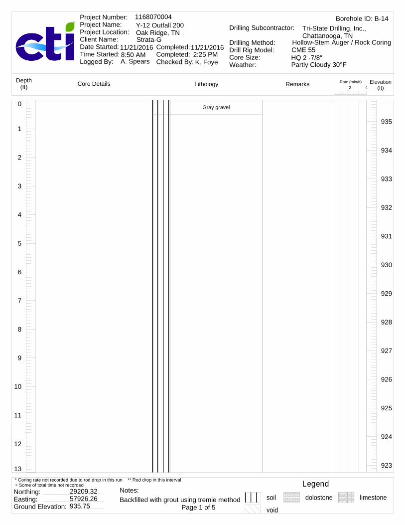
13
12
11
10
9
8
7
6
5
4
3
2
1
0 Gray gravel
935
934
933
932
931
930
929
928
927
926
925
924
923
Rate (min/ft)42
LithologyCore Details RemarksDepth(ft)
Elevation(ft)
Borehole ID: B-141168070004Y-12 Outfall 200Oak Ridge, TNStrata-G
Project Number: Project Name: Project Location: Client Name: Date Started: Time Started: Logged By:
Completed: Completed: Checked By:
11/21/2016 11/21/2016
A. Spears K. Foye
Drilling Subcontractor:
Drilling Method:Drill Rig Model:Core Size:Weather:
Tri-State Drilling, Inc., Chattanooga, TN
Hollow-Stem Auger / Rock CoringCME 55HQ 2 -7/8"8:50 AM 2:25 PMPartly Cloudy 30°F
Legendsoil dolostone limestone
Northing: Easting: Ground Elevation:
29209.3257926.26935.75 Page 1 of 5
* Coring rate not recorded due to rod drop in this run ** Rod drop in this interval+ Some of total time not recorded
Backfilled with grout using tremie methodNotes:
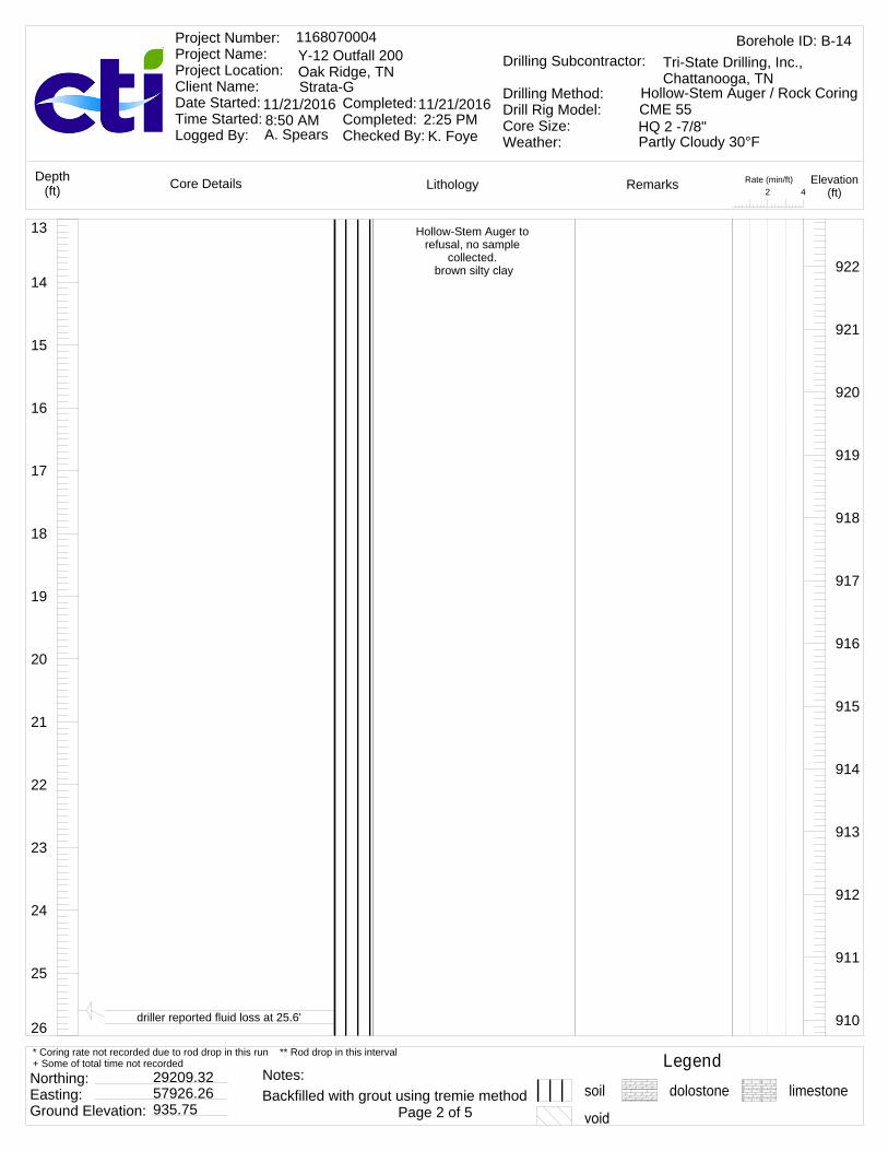
26
25
24
23
22
21
20
19
18
17
16
15
14
13 Hollow-Stem Auger to refusal, no sample
collected. brown silty clay 922
921
920
919
918
917
916
915
914
913
912
911
910driller reported fluid loss at 25.6'
Rate (min/ft)42
LithologyCore Details RemarksDepth(ft)
Elevation(ft)
Borehole ID: B-141168070004Y-12 Outfall 200Oak Ridge, TNStrata-G
Project Number: Project Name: Project Location: Client Name: Date Started: Time Started: Logged By:
Completed: Completed: Checked By:
11/21/2016 11/21/2016
A. Spears K. Foye
Drilling Subcontractor:
Drilling Method:Drill Rig Model:Core Size:Weather:
Tri-State Drilling, Inc., Chattanooga, TN
Hollow-Stem Auger / Rock CoringCME 55HQ 2 -7/8"8:50 AM 2:25 PMPartly Cloudy 30°F
Legendsoil dolostone limestone
Northing: Easting: Ground Elevation:
29209.3257926.26935.75 Page 2 of 5
* Coring rate not recorded due to rod drop in this run ** Rod drop in this interval+ Some of total time not recorded
Backfilled with grout using tremie methodNotes:
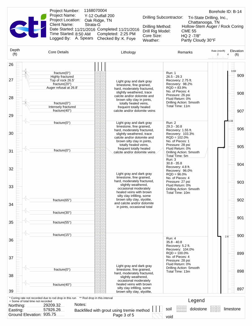
39
38
37
36
35
34
33
32
31
30
29
28
27
26
Light gray and dark gray limestone, fine grained,
hard, moderately fractured, slightly weathered, trace
calcite and/or dolomite and brown silty clay in joints,
totally healed veins, frequent totally healed
calcite and/or dolomite veins
Light gray and dark gray limestone, fine grained,
hard, moderately fractured, slightly weathered, trace
calcite and/or dolomite and brown silty clay in joints,
totally healed veins, frequent totally healed
calcite and/or dolomite veins
Light gray and dark gray limestone, fine grained,
hard, moderately fractured, slightly weathered,
occasional moderately healed veins with brown silty clay infilling, some
brown silty clay, styolite, and calcite and/or dolomite
in joints, occasional total
Light gray and dark gray limestone, fine grained,
hard, moderately fractured, slightly weathered,
occasional moderately healed veins with brown silty clay infilling, some
909
908
907
906
905
904
903
902
901
900
899
898
897
fracture(0°)Highly fracturedTop of rock 26.5'
fracture(20°)Auger refusal at 26.8'
fracture(0°)Intensely fractured
fracture(40°)
fracture(0°)
fracture(0°)
fracture(65°)
fracture(30°)
fracture(55°)
fracture(15°)
fracture(0°)
fracture(40°)
Run: 126.5 - 29.3Recovery: 2.75 ft.Recovery: 98.2%RQD = 83.9%No. of Pieces: 4Pressure: 26 psiFluid Return: 0%Drilling Action: SmoothTotal Time: 11m
Run: 229.3 - 30.8Recovery: 1.55 ft.Recovery: 103.3%RQD = 102.0%No. of Pieces: 1Pressure: 28 psiFluid Return: 0%Drilling Action: SmoothTotal Time: 5mRun: 330.8 - 35.8Recovery: 4.8 ft.Recovery: 96.0%RQD = 96.0%No. of Pieces: 4Pressure: 27 psiFluid Return: 0%Drilling Action: SmoothTotal Time: 10m
Run: 435.8 - 40.8Recovery: 5.2 ft.Recovery: 104.0%RQD = 100.0%No. of Pieces: 4Pressure: 28 psiFluid Return: 0%Drilling Action: SmoothTotal Time: 13m
3.93
3.33
2
2.6
Rate (min/ft)42
LithologyCore Details RemarksDepth(ft)
Elevation(ft)
Borehole ID: B-141168070004Y-12 Outfall 200Oak Ridge, TNStrata-G
Project Number: Project Name: Project Location: Client Name: Date Started: Time Started: Logged By:
Completed: Completed: Checked By:
11/21/2016 11/21/2016
A. Spears K. Foye
Drilling Subcontractor:
Drilling Method:Drill Rig Model:Core Size:Weather:
Tri-State Drilling, Inc., Chattanooga, TN
Hollow-Stem Auger / Rock CoringCME 55HQ 2 -7/8"8:50 AM 2:25 PMPartly Cloudy 30°F
Legendsoil dolostone limestone
Northing: Easting: Ground Elevation:
29209.3257926.26935.75 Page 3 of 5
* Coring rate not recorded due to rod drop in this run ** Rod drop in this interval+ Some of total time not recorded
Backfilled with grout using tremie methodNotes:

52
51
50
49
48
47
46
45
44
43
42
41
40
39 and calcite and/or dolomite in joints, occasional total
Light gray and dark gray limestone, fine grained,
hard, moderately fractured, slightly weathered,
occasional moderately healed veins with brown silty clay infilling, some
brown silty clay, styolite, and calcite and/or dolomite
in joints, occasional total
Light gray and dark gray dolostone, fine grained,
hard, moderately fractured, moderately weathered, frequent totally healed
styolite veins, some brown silty clay, styolite, and
calcite and/or dolomite in joints, occasional totally healed veins with orang
896
895
894
893
892
891
890
889
888
887
886
885
884
fracture(0°)
fracture(20°)
fracture(50°)
fracture(0°)
fracture(35°)
fracture(30°)
fracture(0°)
Run: 540.8 - 45.8Recovery: 4.9 ft.Recovery: 98.0%RQD = 96.0%No. of Pieces: 2Pressure: 26 psiFluid Return: 0%Drilling Action: SmoothTotal Time: 9m
Run: 645.8 - 50.8Recovery: 5.2 ft.Recovery: 104.0%RQD = 102.0%No. of Pieces: 4Pressure: 42 psiFluid Return: 0%Drilling Action: SmoothTotal Time: 10m
Run: 750.8 - 55.8Recovery: 4.75 ft.Recovery: 95.0%
1.8
2
1.4
Rate (min/ft)42
LithologyCore Details RemarksDepth(ft)
Elevation(ft)
Borehole ID: B-141168070004Y-12 Outfall 200Oak Ridge, TNStrata-G
Project Number: Project Name: Project Location: Client Name: Date Started: Time Started: Logged By:
Completed: Completed: Checked By:
11/21/2016 11/21/2016
A. Spears K. Foye
Drilling Subcontractor:
Drilling Method:Drill Rig Model:Core Size:Weather:
Tri-State Drilling, Inc., Chattanooga, TN
Hollow-Stem Auger / Rock CoringCME 55HQ 2 -7/8"8:50 AM 2:25 PMPartly Cloudy 30°F
Legendsoil dolostone limestone
Northing: Easting: Ground Elevation:
29209.3257926.26935.75 Page 4 of 5
* Coring rate not recorded due to rod drop in this run ** Rod drop in this interval+ Some of total time not recorded
Backfilled with grout using tremie methodNotes:
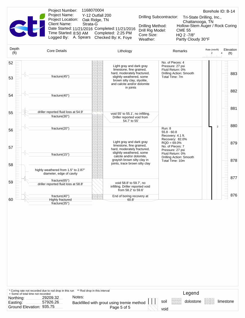
60
59
58
57
56
55
54
53
52Light gray and dark gray limestone, fine grained,
hard, moderately fractured, slightly weathered, some brown silty clay, styolite,
and calcite and/or dolomite in joints
void 55' to 55.1', no infilling. Driller reported void from
54.7' to 55'
Light gray and dark gray limestone, fine grained,
hard, moderately fractured, slightly weathered, some calcite and/or dolomite,
grayish brown silty clay in joints, trace brown silty clay
void 58.8' to 59.7', no infilling. Driller reported void
from 58.2' to 59.6'
End of boring recovery at 60.8'
883
882
881
880
879
878
877
876
fracture(45°)
fracture(40°)
driller reported fluid loss at 54.9'fracture(30°)
fracture(20°)
fracture(15°)
highly weathered from 1.5" to 2.87" diameter, edge of cavity
fracture(65°)driller reported fluid loss at 58.8'
fracture(40°)Highly fractured
fracture(35°)
No. of Pieces: 4Pressure: 27 psiFluid Return: 0%Drilling Action: SmoothTotal Time: 7m
Run: 855.8 - 60.8Recovery: 4.1 ft.Recovery: 82.0%RQD = 69.0%No. of Pieces: 7Pressure: 27 psiFluid Return: 0%Drilling Action: SmoothTotal Time: 10m
2
Rate (min/ft)42
LithologyCore Details RemarksDepth(ft)
Elevation(ft)
Borehole ID: B-141168070004Y-12 Outfall 200Oak Ridge, TNStrata-G
Project Number: Project Name: Project Location: Client Name: Date Started: Time Started: Logged By:
Completed: Completed: Checked By:
11/21/2016 11/21/2016
A. Spears K. Foye
Drilling Subcontractor:
Drilling Method:Drill Rig Model:Core Size:Weather:
Tri-State Drilling, Inc., Chattanooga, TN
Hollow-Stem Auger / Rock CoringCME 55HQ 2 -7/8"8:50 AM 2:25 PMPartly Cloudy 30°F
Legendsoil dolostone limestone
Northing: Easting: Ground Elevation:
29209.3257926.26935.75 Page 5 of 5
* Coring rate not recorded due to rod drop in this run ** Rod drop in this interval+ Some of total time not recorded
Backfilled with grout using tremie methodNotes:

13
12
11
10
9
8
7
6
5
4
3
2
1
0 Gray gravel
Hollow-Stem Auger to refusal, no sample
collected. brown silty clay
926
925
924
923
922
921
920
919
918
917
916
915
914
Rate (min/ft)42
LithologyCore Details RemarksDepth(ft)
Elevation(ft)
Borehole ID: B-151168070004Y-12 Outfall 200Oak Ridge, TNStrata-G
Project Number: Project Name: Project Location: Client Name: Date Started: Time Started: Logged By:
Completed: Completed: Checked By:
11/18/2016 11/18/2016
A. Spears K. Foye
Drilling Subcontractor:
Drilling Method:Drill Rig Model:Core Size:Weather:
Tri-State Drilling, Inc., Chattanooga, TN
Hollow-Stem Auger / Rock CoringCME 55HQ 2 -7/8"7:00 AM 10:50 AMSunny 43°F
Legendsoil dolostone limestone
Northing: Easting: Ground Elevation:
28993.8261431.31926.58 Page 1 of 5
* Coring rate not recorded due to rod drop in this run ** Rod drop in this interval+ Some of total time not recorded
Backfilled with grout using tremie methodNotes:
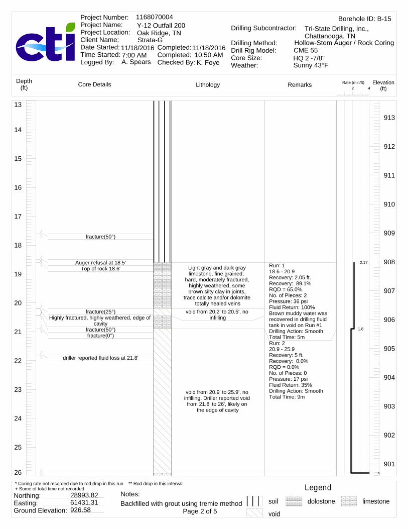
26
25
24
23
22
21
20
19
18
17
16
15
14
13
Light gray and dark gray limestone, fine grained,
hard, moderately fractured, highly weathered, some brown silty clay in joints,
trace calcite and/or dolomite totally healed veins
void from 20.2' to 20.5', no infilling
void from 20.9' to 25.9', no infilling. Driller reported void from 21.8' to 26', likely on
the edge of cavity
913
912
911
910
909
908
907
906
905
904
903
902
901
fracture(50°)
Auger refusal at 18.5'Top of rock 18.6'
fracture(25°)Highly fractured, highly weathered, edge of
cavityfracture(50°)fracture(0°)
driller reported fluid loss at 21.8'
Run: 118.6 - 20.9Recovery: 2.05 ft.Recovery: 89.1%RQD = 65.0%No. of Pieces: 2Pressure: 36 psiFluid Return: 100%Brown muddy water was recovered in drilling fluid tank in void on Run #1Drilling Action: SmoothTotal Time: 5mRun: 220.9 - 25.9Recovery: 5 ft.Recovery: 0.0%RQD = 0.0%No. of Pieces: 0Pressure: 17 psiFluid Return: 35%Drilling Action: SmoothTotal Time: 9m
2.17
1.8
4
Rate (min/ft)42
LithologyCore Details RemarksDepth(ft)
Elevation(ft)
Borehole ID: B-151168070004Y-12 Outfall 200Oak Ridge, TNStrata-G
Project Number: Project Name: Project Location: Client Name: Date Started: Time Started: Logged By:
Completed: Completed: Checked By:
11/18/2016 11/18/2016
A. Spears K. Foye
Drilling Subcontractor:
Drilling Method:Drill Rig Model:Core Size:Weather:
Tri-State Drilling, Inc., Chattanooga, TN
Hollow-Stem Auger / Rock CoringCME 55HQ 2 -7/8"7:00 AM 10:50 AMSunny 43°F
Legendsoil dolostone limestone
Northing: Easting: Ground Elevation:
28993.8261431.31926.58 Page 2 of 5
* Coring rate not recorded due to rod drop in this run ** Rod drop in this interval+ Some of total time not recorded
Backfilled with grout using tremie methodNotes:
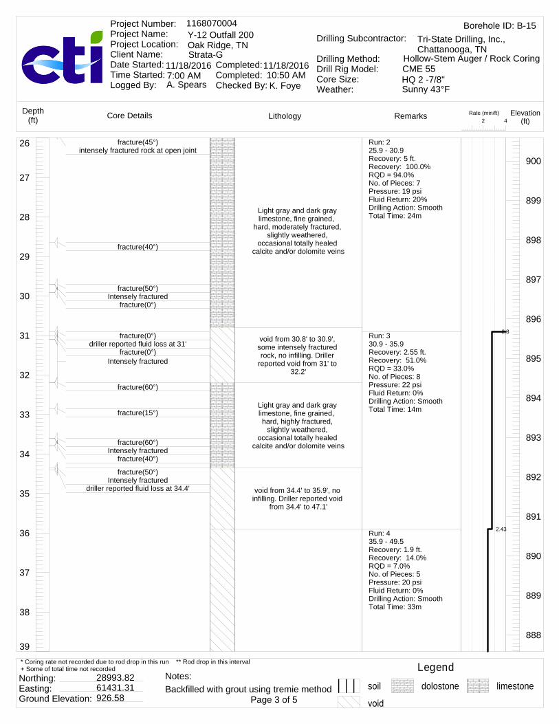
39
38
37
36
35
34
33
32
31
30
29
28
27
26
Light gray and dark gray limestone, fine grained,
hard, moderately fractured, slightly weathered,
occasional totally healed calcite and/or dolomite veins
void from 30.8' to 30.9', some intensely fractured rock, no infilling. Driller
reported void from 31' to 32.2'
Light gray and dark gray limestone, fine grained, hard, highly fractured,
slightly weathered, occasional totally healed
calcite and/or dolomite veins
void from 34.4' to 35.9', no infilling. Driller reported void
from 34.4' to 47.1'
900
899
898
897
896
895
894
893
892
891
890
889
888
fracture(45°)intensely fractured rock at open joint
fracture(40°)
fracture(50°)Intensely fractured
fracture(0°)
fracture(0°)driller reported fluid loss at 31'
fracture(0°)Intensely fractured
fracture(60°)
fracture(15°)
fracture(60°)Intensely fractured
fracture(40°)
fracture(50°)Intensely fractured
driller reported fluid loss at 34.4'
Run: 225.9 - 30.9Recovery: 5 ft.Recovery: 100.0%RQD = 94.0%No. of Pieces: 7Pressure: 19 psiFluid Return: 20%Drilling Action: SmoothTotal Time: 24m
Run: 330.9 - 35.9Recovery: 2.55 ft.Recovery: 51.0%RQD = 33.0%No. of Pieces: 8Pressure: 22 psiFluid Return: 0%Drilling Action: SmoothTotal Time: 14m
Run: 435.9 - 49.5Recovery: 1.9 ft.Recovery: 14.0%RQD = 7.0%No. of Pieces: 5Pressure: 20 psiFluid Return: 0%Drilling Action: SmoothTotal Time: 33m
2.8
2.43
Rate (min/ft)42
LithologyCore Details RemarksDepth(ft)
Elevation(ft)
Borehole ID: B-151168070004Y-12 Outfall 200Oak Ridge, TNStrata-G
Project Number: Project Name: Project Location: Client Name: Date Started: Time Started: Logged By:
Completed: Completed: Checked By:
11/18/2016 11/18/2016
A. Spears K. Foye
Drilling Subcontractor:
Drilling Method:Drill Rig Model:Core Size:Weather:
Tri-State Drilling, Inc., Chattanooga, TN
Hollow-Stem Auger / Rock CoringCME 55HQ 2 -7/8"7:00 AM 10:50 AMSunny 43°F
Legendsoil dolostone limestone
Northing: Easting: Ground Elevation:
28993.8261431.31926.58 Page 3 of 5
* Coring rate not recorded due to rod drop in this run ** Rod drop in this interval+ Some of total time not recorded
Backfilled with grout using tremie methodNotes:

52
51
50
49
48
47
46
45
44
43
42
41
40
39
void from 35.9' to 47.1, no infilling
Light gray and dark gray limestone, fine grained,
hard, highly fractured, highly weathered, some brown
silty clay and calcite and/or dolomite in joints, frequent moderately healed veins
with brown silty clay infilling
void from 49' to 49.5', no infilling. Driller reported void
from 49' to 49.5'End of boring recovery at 49'
887
886
885
884
883
882
881
880
879
878
877
876
875
fracture(50°)fracture(40°)
fracture(15°)
fracture(50°)
fracture(0°)
Rate (min/ft)42
LithologyCore Details RemarksDepth(ft)
Elevation(ft)
Borehole ID: B-151168070004Y-12 Outfall 200Oak Ridge, TNStrata-G
Project Number: Project Name: Project Location: Client Name: Date Started: Time Started: Logged By:
Completed: Completed: Checked By:
11/18/2016 11/18/2016
A. Spears K. Foye
Drilling Subcontractor:
Drilling Method:Drill Rig Model:Core Size:Weather:
Tri-State Drilling, Inc., Chattanooga, TN
Hollow-Stem Auger / Rock CoringCME 55HQ 2 -7/8"7:00 AM 10:50 AMSunny 43°F
Legendsoil dolostone limestone
Northing: Easting: Ground Elevation:
28993.8261431.31926.58 Page 4 of 5
* Coring rate not recorded due to rod drop in this run ** Rod drop in this interval+ Some of total time not recorded
Backfilled with grout using tremie methodNotes:
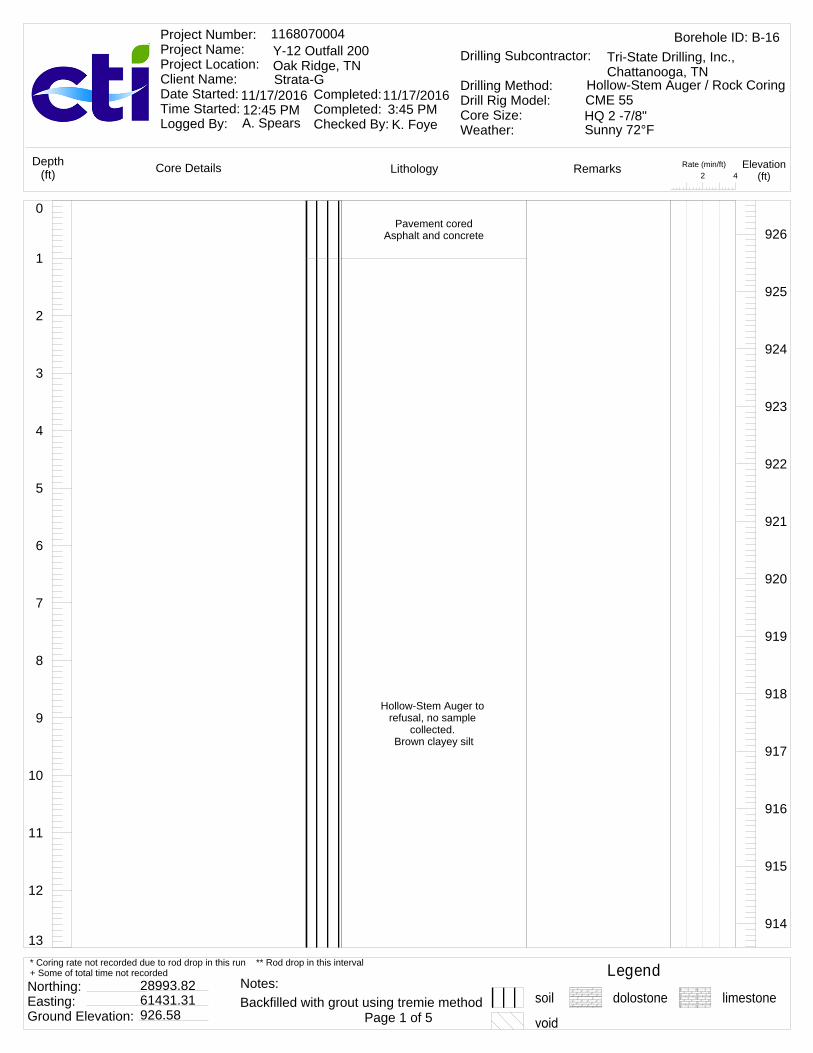
13
12
11
10
9
8
7
6
5
4
3
2
1
0Pavement cored
Asphalt and concrete
Hollow-Stem Auger to refusal, no sample
collected. Brown clayey silt
926
925
924
923
922
921
920
919
918
917
916
915
914
Rate (min/ft)42
LithologyCore Details RemarksDepth(ft)
Elevation(ft)
Borehole ID: B-161168070004Y-12 Outfall 200Oak Ridge, TNStrata-G
Project Number: Project Name: Project Location: Client Name: Date Started: Time Started: Logged By:
Completed: Completed: Checked By:
11/17/2016 11/17/2016
A. Spears K. Foye
Drilling Subcontractor:
Drilling Method:Drill Rig Model:Core Size:Weather:
Tri-State Drilling, Inc., Chattanooga, TN
Hollow-Stem Auger / Rock CoringCME 55HQ 2 -7/8"12:45 PM 3:45 PMSunny 72°F
Legendsoil dolostone limestone
Northing: Easting: Ground Elevation:
28993.8261431.31926.58 Page 1 of 5
* Coring rate not recorded due to rod drop in this run ** Rod drop in this interval+ Some of total time not recorded
Backfilled with grout using tremie methodNotes:

26
25
24
23
22
21
20
19
18
17
16
15
14
13
Light and dark gray limestone, fine grained, moderately fractured,
slightly weathered, hard, totally healed veins,
occasional totally healed calcite and/or dolomite veins, some brown silty
sand, calcite and/or dolomite , and styolite
Light and dark gray limestone, fine grained, moderately fractured,
slightly weathered, hard, totally healed veins,
occasional totally healed calcite and/or dolomite
veins, trace calcite and/or dolomite , styolite, and brown silty clay in joints
913
912
911
910
909
908
907
906
905
904
903
902
901
Top of rock 17.2'fracture(40°)
Auger refusal at 17.3'fracture(35°)
fracture(15°)
fracture(20°)
fracture(0°)
fracture(0°)fracture(15°)fracture(0°)
fracture(70°)
fracture(0°)
Highly fractured
fracture(85°)
Run: 117.2 - 21Recovery: 3.8 ft.Recovery: 100.0%RQD = 86.0%No. of Pieces: 7Pressure: 27 psiFluid Return: 100%Drilling Action: SmoothTotal Time: 6m
Run: 221 - 26Recovery: 5 ft.Recovery: 100.0%RQD = 88.0%No. of Pieces: 7Pressure: 28 psiFluid Return: 100%Drilling Action: SmoothTotal Time: 4m
1.58
0.8
1
Rate (min/ft)42
LithologyCore Details RemarksDepth(ft)
Elevation(ft)
Borehole ID: B-161168070004Y-12 Outfall 200Oak Ridge, TNStrata-G
Project Number: Project Name: Project Location: Client Name: Date Started: Time Started: Logged By:
Completed: Completed: Checked By:
11/17/2016 11/17/2016
A. Spears K. Foye
Drilling Subcontractor:
Drilling Method:Drill Rig Model:Core Size:Weather:
Tri-State Drilling, Inc., Chattanooga, TN
Hollow-Stem Auger / Rock CoringCME 55HQ 2 -7/8"12:45 PM 3:45 PMSunny 72°F
Legendsoil dolostone limestone
Northing: Easting: Ground Elevation:
28993.8261431.31926.58 Page 2 of 5
* Coring rate not recorded due to rod drop in this run ** Rod drop in this interval+ Some of total time not recorded
Backfilled with grout using tremie methodNotes:
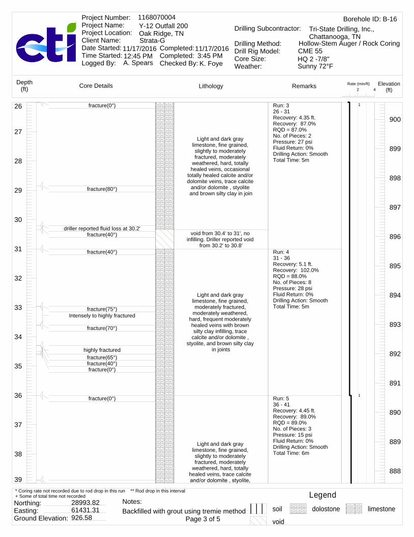
39
38
37
36
35
34
33
32
31
30
29
28
27
26
Light and dark gray limestone, fine grained, slightly to moderately fractured, moderately
weathered, hard, totally healed veins, occasional
totally healed calcite and/or dolomite veins, trace calcite
and/or dolomite , styolite and brown silty clay in join
void from 30.4' to 31', no infilling. Driller reported void
from 30.2' to 30.8'
Light and dark gray limestone, fine grained, moderately fractured,
moderately weathered, hard, frequent moderately healed veins with brown silty clay infilling, trace
calcite and/or dolomite , styolite, and brown silty clay
in joints
Light and dark gray limestone, fine grained, slightly to moderately fractured, moderately
weathered, hard, totally healed veins, trace calcite
900
899
898
897
896
895
894
893
892
891
890
889
888
fracture(0°)
fracture(80°)
driller reported fluid loss at 30.2'fracture(40°)
fracture(40°)
fracture(75°)Intensely to highly fractured
fracture(70°)
highly fracturedfracture(65°)fracture(40°)fracture(0°)
fracture(0°)
Run: 326 - 31Recovery: 4.35 ft.Recovery: 87.0%RQD = 87.0%No. of Pieces: 2Pressure: 27 psiFluid Return: 0%Drilling Action: SmoothTotal Time: 5m
Run: 431 - 36Recovery: 5.1 ft.Recovery: 102.0%RQD = 88.0%No. of Pieces: 8Pressure: 28 psiFluid Return: 0%Drilling Action: SmoothTotal Time: 5m
Run: 536 - 41Recovery: 4.45 ft.Recovery: 89.0%RQD = 89.0%No. of Pieces: 3Pressure: 15 psiFluid Return: 0%Drilling Action: SmoothTotal Time: 6m
1
1
Rate (min/ft)42
LithologyCore Details RemarksDepth(ft)
Elevation(ft)
Borehole ID: B-161168070004Y-12 Outfall 200Oak Ridge, TNStrata-G
Project Number: Project Name: Project Location: Client Name: Date Started: Time Started: Logged By:
Completed: Completed: Checked By:
11/17/2016 11/17/2016
A. Spears K. Foye
Drilling Subcontractor:
Drilling Method:Drill Rig Model:Core Size:Weather:
Tri-State Drilling, Inc., Chattanooga, TN
Hollow-Stem Auger / Rock CoringCME 55HQ 2 -7/8"12:45 PM 3:45 PMSunny 72°F
Legendsoil dolostone limestone
Northing: Easting: Ground Elevation:
28993.8261431.31926.58 Page 3 of 5
* Coring rate not recorded due to rod drop in this run ** Rod drop in this interval+ Some of total time not recorded
Backfilled with grout using tremie methodNotes:

52
51
50
49
48
47
46
45
44
43
42
41
40
39 and brown silty clay in joints
void from 40.5' to 41', no infilling. Driller reported void
from 40.6' to 42.2'
void from 41' to 42.4', no infilling
Light and dark gray limestone, fine grained, moderately fractured,
moderately weathered, hard, totally healed veins,
trace calcite and/or dolomite , styolite, and brown silty
clay in joints
Light and dark gray limestone, fine grained,
highly fractured, moderately weathered, hard, totally
healed veins, trace calcite and/or dolomite , styolite,
and some brown silty clay in joints
void from 47' to 48.6', some highly fractured rock, no
infilling. Driller reported void from 46.9' to 47.7'
Light and dark gray limestone, fine grained,
highly fractured, moderately weathered, hard, totally
healed veins, trace calcite and/or dolomite , styolite,
and some brown silty clay in joints
End of boring recovery at 50'
887
886
885
884
883
882
881
880
879
878
877
876
875
fracture(40°)
fracture(30°)highly fractured
fracture(60°)Highly weathered open joint
driller reported fluid loss at 40.5'
fracture(40°)
fracture(55°)
fracture(0°)
fracture(40°)
fracture(50°)driller reported fluid loss at 47'
fracture(50°)
fracture(20°)
fracture(0°)
Run: 641 - 46Recovery: 3.6 ft.Recovery: 72.0%RQD = 72.0%No. of Pieces: 3Pressure: 20 psiFluid Return: 0%Drilling Action: SmoothTotal Time: 5m
Run: 746 - 50Recovery: 2.5 ft.Recovery: 62.5%RQD = 49.0%No. of Pieces: 6Pressure: 22 psiFluid Return: 0%Drilling Action: SmoothTotal Time: 5m
1.2
1
1.25
Rate (min/ft)42
LithologyCore Details RemarksDepth(ft)
Elevation(ft)
Borehole ID: B-161168070004Y-12 Outfall 200Oak Ridge, TNStrata-G
Project Number: Project Name: Project Location: Client Name: Date Started: Time Started: Logged By:
Completed: Completed: Checked By:
11/17/2016 11/17/2016
A. Spears K. Foye
Drilling Subcontractor:
Drilling Method:Drill Rig Model:Core Size:Weather:
Tri-State Drilling, Inc., Chattanooga, TN
Hollow-Stem Auger / Rock CoringCME 55HQ 2 -7/8"12:45 PM 3:45 PMSunny 72°F
Legendsoil dolostone limestone
Northing: Easting: Ground Elevation:
28993.8261431.31926.58 Page 4 of 5
* Coring rate not recorded due to rod drop in this run ** Rod drop in this interval+ Some of total time not recorded
Backfilled with grout using tremie methodNotes:

13
12
11
10
9
8
7
6
5
4
3
2
1
0Pavement cored
Asphalt and concrete
Hollow-Stem Auger to refusal, no sample
collected. Brown clayey silt
926
925
924
923
922
921
920
919
918
917
916
915
914
Rate (min/ft)42
LithologyCore Details RemarksDepth(ft)
Elevation(ft)
Borehole ID: B-171168070004Y-12 Outfall 200Oak Ridge, TNStrata-G
Project Number: Project Name: Project Location: Client Name: Date Started: Time Started: Logged By:
Completed: Completed: Checked By:
11/17/2016 11/17/2016
A. Spears K. Foye
Drilling Subcontractor:
Drilling Method:Drill Rig Model:Core Size:Weather:
Tri-State Drilling, Inc., Chattanooga, TN
Hollow-Stem Auger / Rock CoringCME 55HQ 2 -7/8"8:03 AM 10:45 AMSunny 45°F
Legendsoil dolostone limestone
Northing: Easting: Ground Elevation:
29014.2361461.93926.39 Page 1 of 5
* Coring rate not recorded due to rod drop in this run ** Rod drop in this interval+ Some of total time not recorded
Backfilled with grout using tremie methodNotes:

26
25
24
23
22
21
20
19
18
17
16
15
14
13
Light and dark gray limestone and dolostone,
fine grained, slightly to moderately fractured,
slightly weathered, hard, trace brown silty clay and calcite and/or dolomite in
joints
Light and dark gray limestone and dolostone, fine grained, moderately
fractured, slightly weathered, hard, trace
brown silty clay and calcite and/or dolomite in joints
913
912
911
910
909
908
907
906
905
904
903
902
901
Auger refusal at 16'Top of rock 16.1'
fracture(angle unknown, >0°), some brown silty clay with intensely fractured rock at
open joint
fracture(65°)
fracture(0°)
fracture(35°)
fracture(0°)
fracture(0°)
fracture(0°)
Run: 116.1 - 20.7Recovery: 4.6 ft.Recovery: 100.0%RQD = 100.0%No. of Pieces: 2Pressure: 27 psiFluid Return: 100%Drilling Action: SmoothTotal Time: 11m
Run: 220.7 - 25.7Recovery: 5 ft.Recovery: 100.0%RQD = 100.0%No. of Pieces: 4Pressure: 22 psiFluid Return: 100%Drilling Action: SmoothTotal Time: 5m:32s
2.39
1.11
1.19
Rate (min/ft)42
LithologyCore Details RemarksDepth(ft)
Elevation(ft)
Borehole ID: B-171168070004Y-12 Outfall 200Oak Ridge, TNStrata-G
Project Number: Project Name: Project Location: Client Name: Date Started: Time Started: Logged By:
Completed: Completed: Checked By:
11/17/2016 11/17/2016
A. Spears K. Foye
Drilling Subcontractor:
Drilling Method:Drill Rig Model:Core Size:Weather:
Tri-State Drilling, Inc., Chattanooga, TN
Hollow-Stem Auger / Rock CoringCME 55HQ 2 -7/8"8:03 AM 10:45 AMSunny 45°F
Legendsoil dolostone limestone
Northing: Easting: Ground Elevation:
29014.2361461.93926.39 Page 2 of 5
* Coring rate not recorded due to rod drop in this run ** Rod drop in this interval+ Some of total time not recorded
Backfilled with grout using tremie methodNotes:
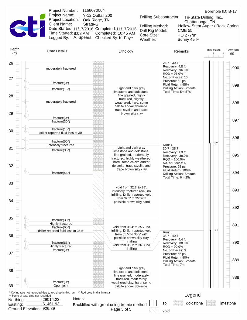
39
38
37
36
35
34
33
32
31
30
29
28
27
26
Light and dark gray limestone and dolostone,
fine grained, highly fractured, slightly
weathered, hard, some calcite and/or dolomite trace styolite and trace
brown silty clay
Light and dark gray limestone and dolostone, fine grained, moderately
fractured, highly weathered, hard, some calcite and/or
dolomite trace styolite and trace brown silty clay
void from 32.3' to 35', intensely fractured rock, no infilling. Driller reported void
from 32.3' to 35' with possible brown silty sand
void from 35.4' to 35.7, no infilling. Driller reported void
from 35.5' to 36.2' with possible brown silty clay
infillingvoid from 35.7' to 36.3, no
infilling
Light and dark gray limestone and dolostone, fine grained, moderately
fractured, moderately weathered clay, hard, some
900
899
898
897
896
895
894
893
892
891
890
889
888
moderately fractured
fracture(0°)
fracture(15°)
moderately fractured
fracture(0°)fracture(30°)
fracture(15°)driller reported fluid loss at 30'
fracture(50°)Intensely fractured
fracture(35°)
fracture(45°)
fracture(30°)Highly fractured
fracture(65°)driller reported fluid loss at 35.5'
fracture(65°)Highly fractured
fracture(0°)
fracture(0°)Open joint
25.7 - 30.7Recovery: 4.8 ft.Recovery: 96.0%RQD = 95.0%No. of Pieces: 10Pressure: 62 psiFluid Return: 95%Drilling Action: SmoothTotal Time: 5m:57s
Run: 430.7 - 35.7Recovery: 1.9 ft.Recovery: 38.0%RQD = 100.0%No. of Pieces: 4Pressure: 25 psiFluid Return: 100%Drilling Action: SmoothTotal Time: 6m:25s
Run: 535.7 - 40.7Recovery: 4.4 ft.Recovery: 88.0%RQD = 90.0%No. of Pieces: 3Pressure: 55 psiFluid Return: 90%Drilling Action: SmoothTotal Time: 7m
1.28
1.4
Rate (min/ft)42
LithologyCore Details RemarksDepth(ft)
Elevation(ft)
Borehole ID: B-171168070004Y-12 Outfall 200Oak Ridge, TNStrata-G
Project Number: Project Name: Project Location: Client Name: Date Started: Time Started: Logged By:
Completed: Completed: Checked By:
11/17/2016 11/17/2016
A. Spears K. Foye
Drilling Subcontractor:
Drilling Method:Drill Rig Model:Core Size:Weather:
Tri-State Drilling, Inc., Chattanooga, TN
Hollow-Stem Auger / Rock CoringCME 55HQ 2 -7/8"8:03 AM 10:45 AMSunny 45°F
Legendsoil dolostone limestone
Northing: Easting: Ground Elevation:
29014.2361461.93926.39 Page 3 of 5
* Coring rate not recorded due to rod drop in this run ** Rod drop in this interval+ Some of total time not recorded
Backfilled with grout using tremie methodNotes:
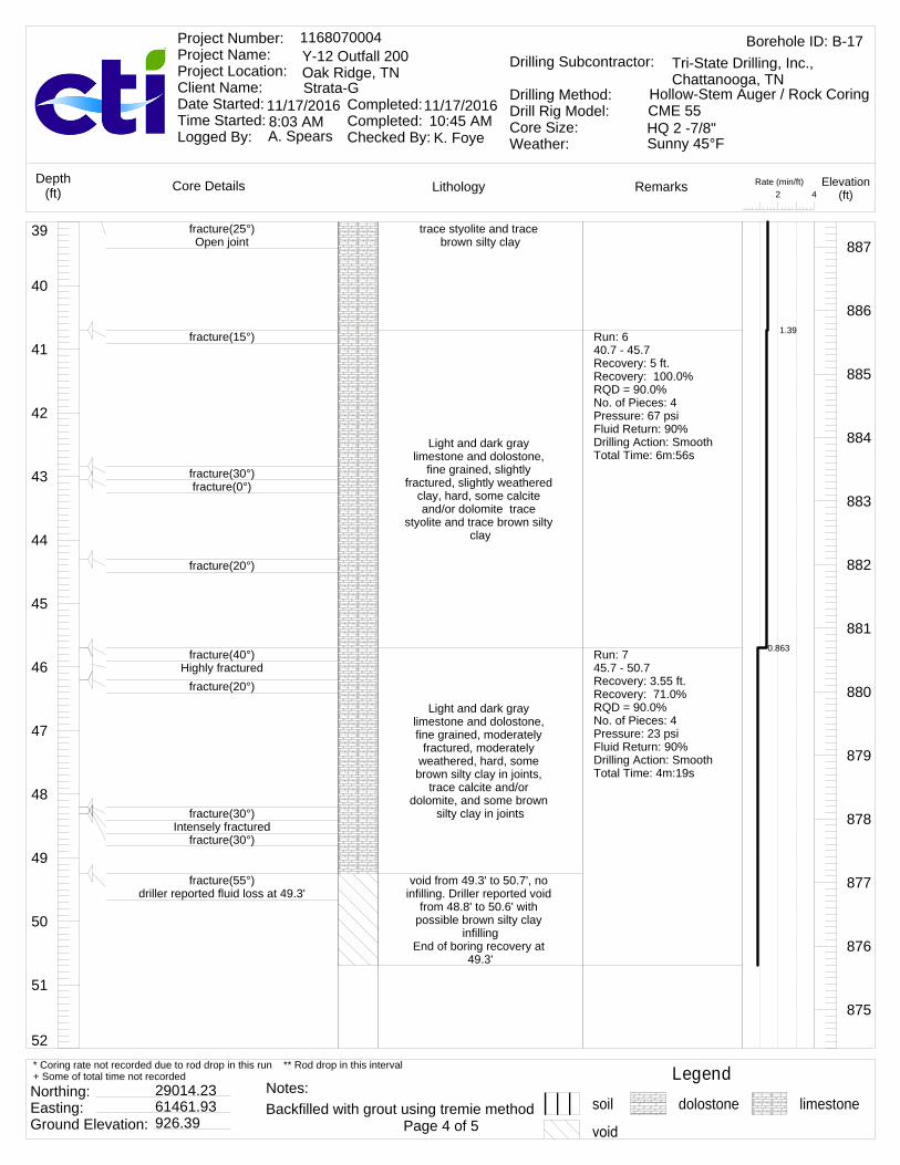
52
51
50
49
48
47
46
45
44
43
42
41
40
39 trace styolite and trace brown silty clay
Light and dark gray limestone and dolostone,
fine grained, slightly fractured, slightly weathered
clay, hard, some calcite and/or dolomite trace
styolite and trace brown silty clay
Light and dark gray limestone and dolostone, fine grained, moderately
fractured, moderately weathered, hard, some brown silty clay in joints,
trace calcite and/or dolomite, and some brown
silty clay in joints
void from 49.3' to 50.7', no infilling. Driller reported void
from 48.8' to 50.6' with possible brown silty clay
infillingEnd of boring recovery at
49.3'
887
886
885
884
883
882
881
880
879
878
877
876
875
fracture(25°)Open joint
fracture(15°)
fracture(30°)fracture(0°)
fracture(20°)
fracture(40°)Highly fractured
fracture(20°)
fracture(30°)Intensely fractured
fracture(30°)
fracture(55°)driller reported fluid loss at 49.3'
Run: 640.7 - 45.7Recovery: 5 ft.Recovery: 100.0%RQD = 90.0%No. of Pieces: 4Pressure: 67 psiFluid Return: 90%Drilling Action: SmoothTotal Time: 6m:56s
Run: 745.7 - 50.7Recovery: 3.55 ft.Recovery: 71.0%RQD = 90.0%No. of Pieces: 4Pressure: 23 psiFluid Return: 90%Drilling Action: SmoothTotal Time: 4m:19s
1.39
0.863
Rate (min/ft)42
LithologyCore Details RemarksDepth(ft)
Elevation(ft)
Borehole ID: B-171168070004Y-12 Outfall 200Oak Ridge, TNStrata-G
Project Number: Project Name: Project Location: Client Name: Date Started: Time Started: Logged By:
Completed: Completed: Checked By:
11/17/2016 11/17/2016
A. Spears K. Foye
Drilling Subcontractor:
Drilling Method:Drill Rig Model:Core Size:Weather:
Tri-State Drilling, Inc., Chattanooga, TN
Hollow-Stem Auger / Rock CoringCME 55HQ 2 -7/8"8:03 AM 10:45 AMSunny 45°F
Legendsoil dolostone limestone
Northing: Easting: Ground Elevation:
29014.2361461.93926.39 Page 4 of 5
* Coring rate not recorded due to rod drop in this run ** Rod drop in this interval+ Some of total time not recorded
Backfilled with grout using tremie methodNotes:
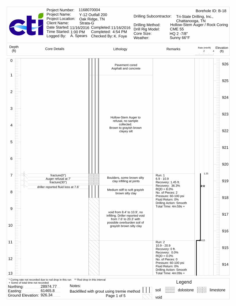
13
12
11
10
9
8
7
6
5
4
3
2
1
0Pavement cored
Asphalt and concrete
Hollow-Stem Auger to refusal, no sample
collected. Brown to grayish brown
clayey silt
Boulders, some brown silty clay infilling at joints
Medium stiff to soft grayish brown silty clay
void from 8.4' to 10.9', no infilling. Driller reported void
from 7.6' to 20.3' with possible overburden soil of
grayish brown silty clay
926
925
924
923
922
921
920
919
918
917
916
915
914
fracture(0°)Auger refusal at 7'
fracture(30°)driller reported fluid loss at 7.6'
Run: 16.9 - 10.9Recovery: 1.45 ft.Recovery: 36.3%RQD = 8.0%No. of Pieces: 2 Pressure: 60-100 psiFluid Return: 0%Drilling Action: SmoothTotal Time: 4m:59s +
Run: 210.9 - 20.9Recovery: 0 ft.Recovery: 0.0%RQD = 0.0%No. of Pieces: 0Pressure: 60-100 psiFluid Return: 0%Drilling Action: SmoothTotal Time: 4m:09s +
1.25
0.415
**
Rate (min/ft)42
LithologyCore Details RemarksDepth(ft)
Elevation(ft)
Borehole ID: B-181168070004Y-12 Outfall 200Oak Ridge, TNStrata-G
Project Number: Project Name: Project Location: Client Name: Date Started: Time Started: Logged By:
Completed: Completed: Checked By:
11/16/2016 11/16/2016
A. Spears K. Foye
Drilling Subcontractor:
Drilling Method:Drill Rig Model:Core Size:Weather:
Tri-State Drilling, Inc., Chattanooga, TN
Hollow-Stem Auger / Rock CoringCME 55HQ 2 -7/8"1:00 PM 4:54 PMSunny 66°F
Legendsoil dolostone limestone
Northing: Easting: Ground Elevation:
28974.7761465.8926.34 Page 1 of 5
* Coring rate not recorded due to rod drop in this run ** Rod drop in this interval+ Some of total time not recorded
Backfilled with grout using tremie methodNotes:

26
25
24
23
22
21
20
19
18
17
16
15
14
13
void from 10.9' to 20.3', no infilling.
void from 20.3' to 20.9', no infilling. Driller reported
made contact with possible pinnacled rock from 20.3' to
20.9'void from 20.9' to 22.2',
some very soft brown silty clay infilling with intensely
fractured rock. Driller reported void from 20.9' to
22.1'dark gray and light gray limestone, fine grained, highly fractured, highly weathered, hard, some brown silty clay in joints, occasional totally healed
calcite and/or dolomite veinsvoid from 22.6' to 25.9', no
infilling. Driller reported void from 23.1' to 27.2'
913
912
911
910
909
908
907
906
905
904
903
902
901
Top of rock 20.3'
Very soft brown silty clay infilling with intensely fractured rock at open joint
driller reported fluid loss at 22.3'
driller reported fluid loss at 23.1'
Run: 320.9 - 22.2Recovery: 0 ft.Recovery: 0.0%RQD = 0.0%No. of Pieces: 0Pressure: 60-100 psiFluid Return: 0%Drilling Action: SmoothTotal Time: 3m:03s +Run: 422.2 - 25.9Recovery: 1.65 ft.Recovery: 44.6%RQD = 0.0%No. of Pieces: 1Pressure: 42 psiFluid Return: 0%Drilling Action: SmoothTotal Time: 5m
2.35
1.35
2
**
**
Rate (min/ft)42
LithologyCore Details RemarksDepth(ft)
Elevation(ft)
Borehole ID: B-181168070004Y-12 Outfall 200Oak Ridge, TNStrata-G
Project Number: Project Name: Project Location: Client Name: Date Started: Time Started: Logged By:
Completed: Completed: Checked By:
11/16/2016 11/16/2016
A. Spears K. Foye
Drilling Subcontractor:
Drilling Method:Drill Rig Model:Core Size:Weather:
Tri-State Drilling, Inc., Chattanooga, TN
Hollow-Stem Auger / Rock CoringCME 55HQ 2 -7/8"1:00 PM 4:54 PMSunny 66°F
Legendsoil dolostone limestone
Northing: Easting: Ground Elevation:
28974.7761465.8926.34 Page 2 of 5
* Coring rate not recorded due to rod drop in this run ** Rod drop in this interval+ Some of total time not recorded
Backfilled with grout using tremie methodNotes:

39
38
37
36
35
34
33
32
31
30
29
28
27
26void from 25.9' to 27.2',
some highly fractured rock, no infilling
dark gray and light gray limestone, fine grained,
highly to moderately fractured, moderately
weathered, hard, some brown silty clay in joints, occasional totally healed
calcite and/or dolomite veins
dark gray and light gray limestone, fine grained, highly fractured, highly weathered, hard, some brown silty clay in joints, occasional totally healed calcite and/or dolomite
veins, occasional moderately healed veins
with brown silty clay infilling
void from 34.4' to 35.9', no infilling. Driller reported void from 34.4' to 35.9'
dark gray and light gray limestone, fine grained, slightly to moderately
fractured, slightly weathered, hard, trace
900
899
898
897
896
895
894
893
892
891
890
889
888
fracture(30°)fracture(60°)
fracture(30°)driller reported fluid loss at 28'
fracture(25°)
fracture(0°)
fracture(0°)
fracture(60°)Open jointfracture(0°)Open joint
Intensely fracturedfracture(35°)
Moderately fractured, highly weathered to 50% diameter from 32.9' to 33.2'
fracture(40°)Open jointfracture(0°)
fracture(40°)Open jointfracture(0°)
driller reported fluid loss at 34.4'
fracture(0°)
fracture(20°)
Run: 525.9 - 30.9Recovery: 4 ft.Recovery: 80.0%RQD = 59.0%No. of Pieces: 6Pressure: 42 psiFluid Return: 0%Drilling Action: SmoothTotal Time: 10m
Run: 630.9 - 35.9Recovery: 3.45 ft.Recovery: 69.0%RQD = 47.0%No. of Pieces: 7Pressure: 42 psiFluid Return: 0%Drilling Action: SmoothTotal Time: 7m
Run: 735.9 - 40.9Recovery: 5 ft.Recovery: 100.0%RQD = 100.0%No. of Pieces: 4Pressure: 27 psiFluid Return: 0%Drilling Action: SmoothTotal Time: 6m
1.4
1.2
Rate (min/ft)42
LithologyCore Details RemarksDepth(ft)
Elevation(ft)
Borehole ID: B-181168070004Y-12 Outfall 200Oak Ridge, TNStrata-G
Project Number: Project Name: Project Location: Client Name: Date Started: Time Started: Logged By:
Completed: Completed: Checked By:
11/16/2016 11/16/2016
A. Spears K. Foye
Drilling Subcontractor:
Drilling Method:Drill Rig Model:Core Size:Weather:
Tri-State Drilling, Inc., Chattanooga, TN
Hollow-Stem Auger / Rock CoringCME 55HQ 2 -7/8"1:00 PM 4:54 PMSunny 66°F
Legendsoil dolostone limestone
Northing: Easting: Ground Elevation:
28974.7761465.8926.34 Page 3 of 5
* Coring rate not recorded due to rod drop in this run ** Rod drop in this interval+ Some of total time not recorded
Backfilled with grout using tremie methodNotes:

52
51
50
49
48
47
46
45
44
43
42
41
40
39 and calcite and/or dolomite in joints
dark gray and light gray limestone, fine grained, moderately fractured,
slightly weathered, hard, some calcite and/or
dolomite in joints, trace styolite and brown silty clay
dark gray and light gray limestone, fine grained, slightly to moderately
fractured, highly weathered, hard, trace calcite and/or dolomite , styolite, and brown silty clay in joints
End of boring recovery at 50.8'
887
886
885
884
883
882
881
880
879
878
877
876
875
fracture(20°)
fracture(0°)
fracture(0°)
fracture(25°)
fracture(30°)fracture(50°)
fracture(0°)
fracture(55°)
fracture(0°)
Intensely fractured
fracture(50°)
fracture(0°)fracture(0°)
Run: 840.9 - 45.9Recovery: 5 ft.Recovery: 100.0%RQD = 95.0%No. of Pieces: 6Pressure: 23 psiFluid Return: 0%Drilling Action: SmoothTotal Time: 4m +
Run: 945.9 - 50.9Recovery: 4.9 ft.Recovery: %RQD = 96.0%No. of Pieces: 5Pressure: 22 psiFluid Return: 0%Drilling Action: SmoothTotal Time: 7m
0.8
1.4
**
Rate (min/ft)42
LithologyCore Details RemarksDepth(ft)
Elevation(ft)
Borehole ID: B-181168070004Y-12 Outfall 200Oak Ridge, TNStrata-G
Project Number: Project Name: Project Location: Client Name: Date Started: Time Started: Logged By:
Completed: Completed: Checked By:
11/16/2016 11/16/2016
A. Spears K. Foye
Drilling Subcontractor:
Drilling Method:Drill Rig Model:Core Size:Weather:
Tri-State Drilling, Inc., Chattanooga, TN
Hollow-Stem Auger / Rock CoringCME 55HQ 2 -7/8"1:00 PM 4:54 PMSunny 66°F
Legendsoil dolostone limestone
Northing: Easting: Ground Elevation:
28974.7761465.8926.34 Page 4 of 5
* Coring rate not recorded due to rod drop in this run ** Rod drop in this interval+ Some of total time not recorded
Backfilled with grout using tremie methodNotes:

13
12
11
10
9
8
7
6
5
4
3
2
1
0Pavement cored
Asphalt and concrete
Hollow-Stem Auger to refusal, no sample
collected. Gray gravelly clay
926
925
924
923
922
921
920
919
918
917
916
915
914
Rate (min/ft)42
LithologyCore Details RemarksDepth(ft)
Elevation(ft)
Borehole ID: B-191168070004Y-12 Outfall 200Oak Ridge, TNStrata-G
Project Number: Project Name: Project Location: Client Name: Date Started: Time Started: Logged By:
Completed: Completed: Checked By:
11/15/2016 11/15/2016
A. Spears K. Foye
Drilling Subcontractor:
Drilling Method:Drill Rig Model:Core Size:Weather:
Tri-State Drilling, Inc., Chattanooga, TN
Hollow-Stem Auger / Rock CoringCME 55HQ 2 -7/8"9:20 AM 1:40 PMCloudy 41°F
Legendsoil dolostone limestone
Northing: Easting: Ground Elevation:
29007.9161555.54926.37 Page 1 of 5
* Coring rate not recorded due to rod drop in this run ** Rod drop in this interval+ Some of total time not recorded
Backfilled with grout using tremie methodNotes:
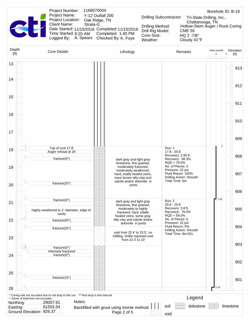
26
25
24
23
22
21
20
19
18
17
16
15
14
13
dark gray and light gray limestone, fine grained, moderately fractured,
moderately weathered, hard, totally healed veins, trace brown silty clay and calcite and/or dolomite in
joints
dark gray and light gray limestone, fine grained,
moderately to highly fractured, hard, totally
healed veins, some gray silty clay and calcite and/or
dolomite in joints
void from 22.4' to 23.5', no infilling. Driller reported void
from 22.3' to 23'
913
912
911
910
909
908
907
906
905
904
903
902
901
Top of rock 17.8'Auger refusal at 18'
fracture(0°)
fracture(20°)
fracture(0°)
Highly weathered to 1" diameter, edge of cavity
fracture(40°)
fracture(20°)
fracture(0°)Intensely fractured
fracture(0°)
fracture(15°)
Run: 117.8 - 20.8Recovery: 2.95 ft.Recovery: 98.3%RQD = 78.0%No. of Pieces: 3Pressure: 22 psiFluid Return: 100%Drilling Action: SmoothTotal Time: 6m
Run: 220.8 - 25.8Recovery: 3.8 ft.Recovery: 76.0%RQD = 59.0%No. of Pieces: 5Pressure: 22 psiFluid Return: 0%Drilling Action: SmoothTotal Time: 8m:02s
2
1.61
1.14
Rate (min/ft)42
LithologyCore Details RemarksDepth(ft)
Elevation(ft)
Borehole ID: B-191168070004Y-12 Outfall 200Oak Ridge, TNStrata-G
Project Number: Project Name: Project Location: Client Name: Date Started: Time Started: Logged By:
Completed: Completed: Checked By:
11/15/2016 11/15/2016
A. Spears K. Foye
Drilling Subcontractor:
Drilling Method:Drill Rig Model:Core Size:Weather:
Tri-State Drilling, Inc., Chattanooga, TN
Hollow-Stem Auger / Rock CoringCME 55HQ 2 -7/8"9:20 AM 1:40 PMCloudy 41°F
Legendsoil dolostone limestone
Northing: Easting: Ground Elevation:
29007.9161555.54926.37 Page 2 of 5
* Coring rate not recorded due to rod drop in this run ** Rod drop in this interval+ Some of total time not recorded
Backfilled with grout using tremie methodNotes:
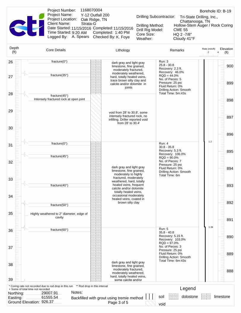
39
38
37
36
35
34
33
32
31
30
29
28
27
26 dark gray and light gray limestone, fine grained, moderately fractured,
moderately weathered, hard, totally healed veins, trace brown silty clay and calcite and/or dolomite in
joints
void from 28' to 30.8', some intensely fractured rock, no infilling. Driller reported void
from 28' to 30.4'
dark gray and light gray limestone, fine grained,
moderately to highly fractured, moderately
weathered, hard, totally healed veins, frequent calcite and/or dolomite
totally healed veins, occasional moderately healed veins, coated in
brown silty clay
dark gray and light gray limestone, fine grained, moderately fractured,
moderately weathered, hard, totally healed veins,
900
899
898
897
896
895
894
893
892
891
890
889
888
fracture(0°)
fracture(35°)
fracture(45°)Intensely fractured rock at open joint
fracture(0°)
fracture(45°)
fracture(40°)
fracture(50°)
Highly weathered to 2" diameter, edge of cavity
fracture(60°)
Run: 325.8 - 30.8Recovery: 2.3 ft.Recovery: 46.0%RQD = 44.0%No. of Pieces: 5Pressure: 25 psiFluid Return: 0%Drilling Action: SmoothTotal Time: 5m:43s
Run: 430.8 - 35.8Recovery: 5.3 ft.Recovery: 106.0%RQD = 90.0%No. of Pieces: 7Pressure: 25 psiFluid Return: 0%Drilling Action: SmoothTotal Time: 6m
Run: 535.8 - 40.8Recovery: 5.15 ft.Recovery: 103.0%RQD = 97.0%No. of Pieces: 3Pressure: 25 psiFluid Return: 0%Drilling Action: SmoothTotal Time: 6m:43s
1.2
1.34
Rate (min/ft)42
LithologyCore Details RemarksDepth(ft)
Elevation(ft)
Borehole ID: B-191168070004Y-12 Outfall 200Oak Ridge, TNStrata-G
Project Number: Project Name: Project Location: Client Name: Date Started: Time Started: Logged By:
Completed: Completed: Checked By:
11/15/2016 11/15/2016
A. Spears K. Foye
Drilling Subcontractor:
Drilling Method:Drill Rig Model:Core Size:Weather:
Tri-State Drilling, Inc., Chattanooga, TN
Hollow-Stem Auger / Rock CoringCME 55HQ 2 -7/8"9:20 AM 1:40 PMCloudy 41°F
Legendsoil dolostone limestone
Northing: Easting: Ground Elevation:
29007.9161555.54926.37 Page 3 of 5
* Coring rate not recorded due to rod drop in this run ** Rod drop in this interval+ Some of total time not recorded
Backfilled with grout using tremie methodNotes:

52
51
50
49
48
47
46
45
44
43
42
41
40
39 dolomite in joints, trace silty clay in joints
void from 44.3' to 51.2', some highly fractured rock, no infilling. Driller reported void from 44.3' to 51.2' and likely reached pinnacle at
51.2'End of boring recovery at
44.3'
887
886
885
884
883
882
881
880
879
878
877
876
875
fracture(60°)
fracture(20°)
fracture(65°)Intensely fractured rock at open joint
fracture(50°)
Run: 540.8 - 45.8Recovery: 3.4 ft.Recovery: 68.0%RQD = 48.0%No. of Pieces: 3Pressure: 25 psiFluid Return: 0%Drilling Action: SmoothTotal Time: 8m:02s
1.61
Rate (min/ft)42
LithologyCore Details RemarksDepth(ft)
Elevation(ft)
Borehole ID: B-191168070004Y-12 Outfall 200Oak Ridge, TNStrata-G
Project Number: Project Name: Project Location: Client Name: Date Started: Time Started: Logged By:
Completed: Completed: Checked By:
11/15/2016 11/15/2016
A. Spears K. Foye
Drilling Subcontractor:
Drilling Method:Drill Rig Model:Core Size:Weather:
Tri-State Drilling, Inc., Chattanooga, TN
Hollow-Stem Auger / Rock CoringCME 55HQ 2 -7/8"9:20 AM 1:40 PMCloudy 41°F
Legendsoil dolostone limestone
Northing: Easting: Ground Elevation:
29007.9161555.54926.37 Page 4 of 5
* Coring rate not recorded due to rod drop in this run ** Rod drop in this interval+ Some of total time not recorded
Backfilled with grout using tremie methodNotes:
fracture(20°)Highly fractured
dark gray and light gray limestone, fine grained, moderately fractured,
moderately weathered, hard, totally healed veins,
some calcite and/or dolomite in joints, trace silty
clay in joints
void from 41.1' to 41.3', some highly fractured rock, no infilling. Driller reported
void from 41.1' to 41.3'
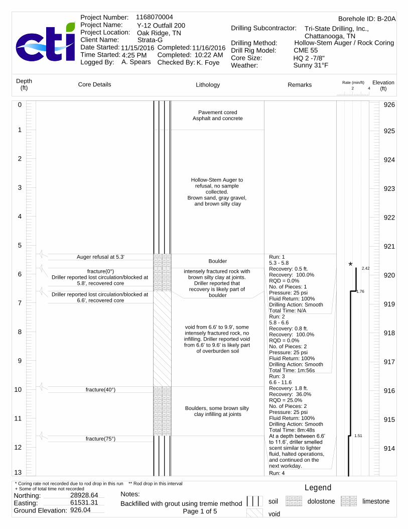
13
12
11
10
9
8
7
6
5
4
3
2
1
0Pavement cored
Asphalt and concrete
Hollow-Stem Auger to refusal, no sample
collected. Brown sand, gray gravel,
and brown silty clay
Boulder
intensely fractured rock with brown silty clay at joints.
Driller reported that recovery is likely part of
boulder
void from 6.6' to 9.9', some intensely fractured rock, no infilling. Driller reported void from 6.6' to 9.6' is likely part
of overburden soil
Boulders, some brown silty clay infilling at joints
926
925
924
923
922
921
920
919
918
917
916
915
914
Auger refusal at 5.3'
fracture(0°)Driller reported lost circulation/blocked at
5.8', recovered core
Driller reported lost circulation/blocked at 6.6', recovered core
fracture(40°)
fracture(75°)
Run: 15.3 - 5.8Recovery: 0.5 ft.Recovery: 100.0%RQD = 0.0%No. of Pieces: 1Pressure: 25 psiFluid Return: 100%Drilling Action: SmoothTotal Time: N/ARun: 25.8 - 6.6Recovery: 0.8 ft.Recovery: 100.0%RQD = 0.0%No. of Pieces: 2Pressure: 25 psiFluid Return: 100%Drilling Action: SmoothTotal Time: 1m:56sRun: 36.6 - 11.6Recovery: 1.8 ft.Recovery: 36.0%RQD = 25.0%No. of Pieces: 2Pressure: 25 psiFluid Return: 100%Drilling Action: SmoothTotal Time: 8m:48s
scent similar to lighter fluid, halted operations, and continued on the next workday.
2.42
1.76
1.51
*
Rate (min/ft)42
LithologyCore Details RemarksDepth(ft)
Elevation(ft)
Borehole ID: B-20A1168070004Y-12 Outfall 200Oak Ridge, TNStrata-G
Project Number: Project Name: Project Location: Client Name: Date Started: Time Started: Logged By:
Completed: Completed: Checked By:
11/15/2016 11/16/2016
A. Spears K. Foye
Drilling Subcontractor:
Drilling Method:Drill Rig Model:Core Size:Weather:
Tri-State Drilling, Inc., Chattanooga, TN
Hollow-Stem Auger / Rock CoringCME 55HQ 2 -7/8"4:25 PM 10:22 AMSunny 31°F
Legendsoil dolostone limestone
Northing: Easting: Ground Elevation:
28928.6461531.31926.04 Page 1 of 5
* Coring rate not recorded due to rod drop in this run ** Rod drop in this interval+ Some of total time not recorded
Backfilled with grout using tremie methodNotes:

26
25
24
23
22
21
20
19
18
17
16
15
14
13
Medium stiff brown silty clay with intensely fractured
rock. Driller reported void from 11.6' to 21.6' is likely
part of overburden soil
Medium stiff brown silty clay with intensely fractured rock.
dark gray and light gray limestone, fine grained,
highly fractured, moderately weathered, totally healed
veins, trace brown silty clay, some calcite and/or
dolomite in joints
913
912
911
910
909
908
907
906
905
904
903
902
901
Top of rock 21.6'fracture(25°)
fracture(0°)fracture(30°)
Moderately fractured
fracture(20°)fracture(0°)
fracture(30°)
11.6 - 16.6Recovery: 1.4 ft.Recovery: 28.0%RQD = 0.0%No. of Pieces: 0Pressure: 75 psiFluid Return: 0%Drilling Action: SmoothTotal Time: 7m:37s
Run: 516.6 - 21.6Recovery: 3.8 ft.Recovery: 76.0%RQD = 0.0%No. of Pieces: 2Pressure: 75 psiFluid Return: 0%Drilling Action: SmoothTotal Time: 7m:53s
Run: 621.6 - 26.6Recovery: 4.25 ft.Recovery: 85.0%RQD = 63.0%No. of Pieces: 6Pressure: 27 psiFluid Return: 0%Drilling Action: SmoothTotal Time: 13m:48s
1.58
2.76
Rate (min/ft)42
LithologyCore Details RemarksDepth(ft)
Elevation(ft)
Borehole ID: B-20A1168070004Y-12 Outfall 200Oak Ridge, TNStrata-G
Project Number: Project Name: Project Location: Client Name: Date Started: Time Started: Logged By:
Completed: Completed: Checked By:
11/15/2016 11/16/2016
A. Spears K. Foye
Drilling Subcontractor:
Drilling Method:Drill Rig Model:Core Size:Weather:
Tri-State Drilling, Inc., Chattanooga, TN
Hollow-Stem Auger / Rock CoringCME 55HQ 2 -7/8"4:25 PM 10:22 AMSunny 31°F
Legendsoil dolostone limestone
Northing: Easting: Ground Elevation:
28928.6461531.31926.04 Page 2 of 5
* Coring rate not recorded due to rod drop in this run ** Rod drop in this interval+ Some of total time not recorded
Backfilled with grout using tremie methodNotes:

39
38
37
36
35
34
33
32
31
30
29
28
27
26 void from 25.9' to 26.6', no infilling. Driller reported void
from 25.5' to 26.9'void from 26.6' to 26.9', soft
grayish brown silty clay infilling
light gray dolostone, fine grained, moderately hard, slightly fractured, slightly weathered, occasional calcite and/or dolomite
veins, some grayish brown silty clay at joints
void from 30.2' to 31.6', no infilling. Driller reported void
from 30.1' to 30.5'
light gray and dark gray, limestone, moderately to
highly fractured, moderately weathered, trace brown silty
clay is calcite and/or dolomite in joints
void from 34.5' to 36.6', no infilling. Driller reported void
from 33.1' to 39.3'
void from 36.6' to 40.3', no infilling
900
899
898
897
896
895
894
893
892
891
890
889
888
driller reported fluid loss at 25.85'
Soft grayish brown infilling at open jointfracture(25°)
fracture(60°)Soft grayish brown infilling at open joint
fracture(35°)
fracture(0°)fracture(15°)fracture(15°)
fracture(0°)
fracture(30°)driller reported fluid loss at 34.5'
Run: 726.6 - 31.6Recovery: 3.6 ft.Recovery: 72.0%RQD = 66.0%No. of Pieces: 1Pressure: 27 psiFluid Return: 0%Drilling Action: SmoothTotal Time: 10m:50s
Run: 831.6 - 36.6Recovery: 2.85 ft.Recovery: 57.0%RQD = 47.0%No. of Pieces: 8Pressure: 32 psiFluid Return: 0%Drilling Action: SmoothTotal Time: 5m:52s
Run: 936.6 - 41.6Recovery: 2 ft.Recovery: 40.0%RQD = 27.0%No. of Pieces: 1Pressure: 33 psiFluid Return: 0%Drilling Action: SmoothTotal Time: N/A
2.17
1.19
*
Rate (min/ft)42
LithologyCore Details RemarksDepth(ft)
Elevation(ft)
Borehole ID: B-20A1168070004Y-12 Outfall 200Oak Ridge, TNStrata-G
Project Number: Project Name: Project Location: Client Name: Date Started: Time Started: Logged By:
Completed: Completed: Checked By:
11/15/2016 11/16/2016
A. Spears K. Foye
Drilling Subcontractor:
Drilling Method:Drill Rig Model:Core Size:Weather:
Tri-State Drilling, Inc., Chattanooga, TN
Hollow-Stem Auger / Rock CoringCME 55HQ 2 -7/8"4:25 PM 10:22 AMSunny 31°F
Legendsoil dolostone limestone
Northing: Easting: Ground Elevation:
28928.6461531.31926.04 Page 3 of 5
* Coring rate not recorded due to rod drop in this run ** Rod drop in this interval+ Some of total time not recorded
Backfilled with grout using tremie methodNotes:
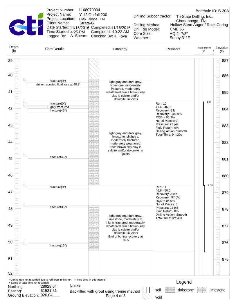
52
51
50
49
48
47
46
45
44
43
42
41
40
39
light gray and dark gray, limestone, moderately fractured, moderately
weathered, trace brown silty clay is calcite and/or
dolomite in joints
light gray and dark gray, limestone, slightly to moderately fractured,
moderately weathered, trace brown silty clay is
calcite and/or dolomite in joints
light gray and dark gray, limestone, moderately to
highly fractured, moderately weathered, trace brown silty
clay is calcite and/or dolomite in joints
End of boring recovery at 50.5'
887
886
885
884
883
882
881
880
879
878
877
876
875
fracture(0°)driller reported fluid loss at 40.3'
fracture(0°)Highly fractured
fracture(45°)
fracture(45°)
fracture(0°)
fracture(35°)
fracture(15°)
Run: 1041.6 - 46.6Recovery: 5 ft.Recovery: 100.0%RQD = 93.3%No. of Pieces: 3Pressure: 22 psiFluid Return: 0%Drilling Action: SmoothTotal Time: 9m:20s
Run: 1146.6 - 50.6Recovery: 3.9 ft.Recovery: 97.5%RQD = 94.0%No. of Pieces: 6Pressure: 22 psiFluid Return: 0%Drilling Action: SmoothTotal Time: 8m:43s
1.87
2.18
Rate (min/ft)42
LithologyCore Details RemarksDepth(ft)
Elevation(ft)
Borehole ID: B-20A1168070004Y-12 Outfall 200Oak Ridge, TNStrata-G
Project Number: Project Name: Project Location: Client Name: Date Started: Time Started: Logged By:
Completed: Completed: Checked By:
11/15/2016 11/16/2016
A. Spears K. Foye
Drilling Subcontractor:
Drilling Method:Drill Rig Model:Core Size:Weather:
Tri-State Drilling, Inc., Chattanooga, TN
Hollow-Stem Auger / Rock CoringCME 55HQ 2 -7/8"4:25 PM 10:22 AMSunny 31°F
Legendsoil dolostone limestone
Northing: Easting: Ground Elevation:
28928.6461531.31926.04 Page 4 of 5
* Coring rate not recorded due to rod drop in this run ** Rod drop in this interval+ Some of total time not recorded
Backfilled with grout using tremie methodNotes:

13
12
11
10
9
8
7
6
5
4
3
2
1
0Pavement cored
Asphalt and concrete
Hollow-Stem Auger to refusal, no sample
collected. Brown sand, gray gravel,
and brown silty clay
926
925
924
923
922
921
920
919
918
917
916
915
914
Rate (min/ft)42
LithologyCore Details RemarksDepth(ft)
Elevation(ft)
Borehole ID: B-211168070004Y-12 Outfall 200Oak Ridge, TNStrata-G
Project Number: Project Name: Project Location: Client Name: Date Started: Time Started: Logged By:
Completed: Completed: Checked By:
11/14/2016 11/14/2016
A. Spears K. Foye
Drilling Subcontractor:
Drilling Method:Drill Rig Model:Core Size:Weather:
Tri-State Drilling, Inc., Chattanooga, TN
Hollow-Stem Auger / Rock CoringCME 55HQ 2 -7/8"1:15 PM 4:30 PMMostly Sunny 63°F
Legendsoil dolostone limestone
Northing: Easting: Ground Elevation:
28960.9861385.12926.43 Page 1 of 5
* Coring rate not recorded due to rod drop in this run ** Rod drop in this interval+ Some of total time not recorded
Backfilled with grout using tremie methodNotes:
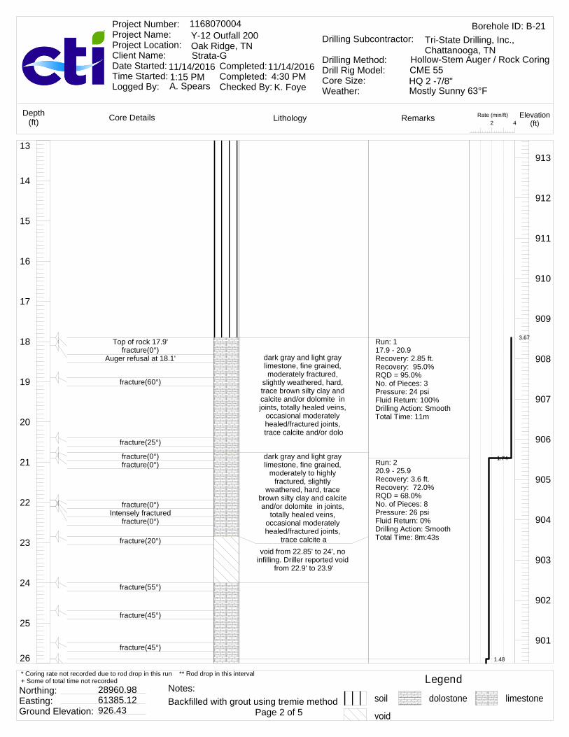
26
25
24
23
22
21
20
19
18
17
16
15
14
13
dark gray and light gray limestone, fine grained, moderately fractured,
slightly weathered, hard, trace brown silty clay and calcite and/or dolomite in joints, totally healed veins,
occasional moderately healed/fractured joints, trace calcite and/or dolo
dark gray and light gray limestone, fine grained,
moderately to highly fractured, slightly
weathered, hard, trace brown silty clay and calcite and/or dolomite in joints,
totally healed veins, occasional moderately healed/fractured joints,
trace calcite avoid from 22.85' to 24', no
infilling. Driller reported void from 22.9' to 23.9'
913
912
911
910
909
908
907
906
905
904
903
902
901
Top of rock 17.9'fracture(0°)
Auger refusal at 18.1'
fracture(60°)
fracture(25°)
fracture(0°)fracture(0°)
fracture(0°)Intensely fractured
fracture(0°)
fracture(20°)
fracture(55°)
fracture(45°)
fracture(45°)
Run: 117.9 - 20.9Recovery: 2.85 ft.Recovery: 95.0%RQD = 95.0%No. of Pieces: 3Pressure: 24 psiFluid Return: 100%Drilling Action: SmoothTotal Time: 11m
Run: 220.9 - 25.9Recovery: 3.6 ft.Recovery: 72.0%RQD = 68.0%No. of Pieces: 8Pressure: 26 psiFluid Return: 0%Drilling Action: SmoothTotal Time: 8m:43s
3.67
1.74
1.48
Rate (min/ft)42
LithologyCore Details RemarksDepth(ft)
Elevation(ft)
Borehole ID: B-211168070004Y-12 Outfall 200Oak Ridge, TNStrata-G
Project Number: Project Name: Project Location: Client Name: Date Started: Time Started: Logged By:
Completed: Completed: Checked By:
11/14/2016 11/14/2016
A. Spears K. Foye
Drilling Subcontractor:
Drilling Method:Drill Rig Model:Core Size:Weather:
Tri-State Drilling, Inc., Chattanooga, TN
Hollow-Stem Auger / Rock CoringCME 55HQ 2 -7/8"1:15 PM 4:30 PMMostly Sunny 63°F
Legendsoil dolostone limestone
Northing: Easting: Ground Elevation:
28960.9861385.12926.43 Page 2 of 5
* Coring rate not recorded due to rod drop in this run ** Rod drop in this interval+ Some of total time not recorded
Backfilled with grout using tremie methodNotes:
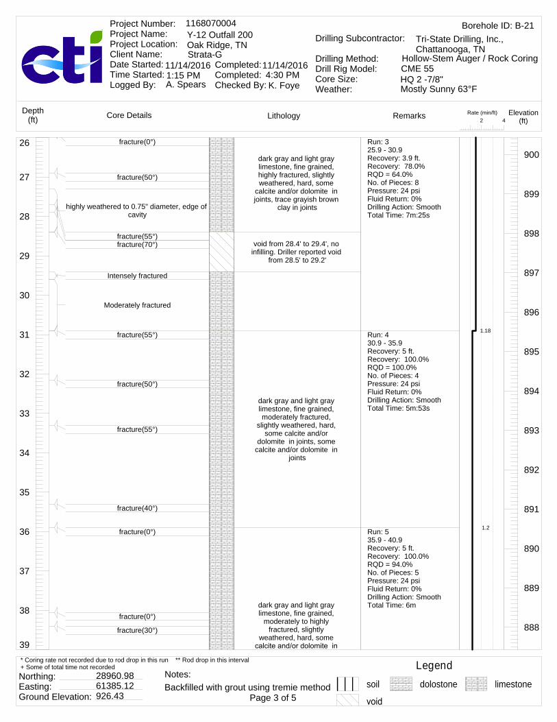
39
38
37
36
35
34
33
32
31
30
29
28
27
26dark gray and light gray limestone, fine grained, highly fractured, slightly weathered, hard, some
calcite and/or dolomite in joints, trace grayish brown
clay in joints
void from 28.4' to 29.4', no infilling. Driller reported void
from 28.5' to 29.2'
dark gray and light gray limestone, fine grained, moderately fractured,
slightly weathered, hard, some calcite and/or
dolomite in joints, some calcite and/or dolomite in
joints
dark gray and light gray limestone, fine grained,
moderately to highly fractured, slightly
weathered, hard, some
900
899
898
897
896
895
894
893
892
891
890
889
888
fracture(0°)
fracture(50°)
highly weathered to 0.75" diameter, edge of cavity
fracture(55°)fracture(70°)
Intensely fractured
Moderately fractured
fracture(55°)
fracture(50°)
fracture(55°)
fracture(40°)
fracture(0°)
fracture(0°)
fracture(30°)
Run: 325.9 - 30.9Recovery: 3.9 ft.Recovery: 78.0%RQD = 64.0%No. of Pieces: 8Pressure: 24 psiFluid Return: 0%Drilling Action: SmoothTotal Time: 7m:25s
Run: 430.9 - 35.9Recovery: 5 ft.Recovery: 100.0%RQD = 100.0%No. of Pieces: 4Pressure: 24 psiFluid Return: 0%Drilling Action: SmoothTotal Time: 5m:53s
Run: 535.9 - 40.9Recovery: 5 ft.Recovery: 100.0%RQD = 94.0%No. of Pieces: 5Pressure: 24 psiFluid Return: 0%Drilling Action: SmoothTotal Time: 6m
1.18
1.2
Rate (min/ft)42
LithologyCore Details RemarksDepth(ft)
Elevation(ft)
Borehole ID: B-211168070004Y-12 Outfall 200Oak Ridge, TNStrata-G
Project Number: Project Name: Project Location: Client Name: Date Started: Time Started: Logged By:
Completed: Completed: Checked By:
11/14/2016 11/14/2016
A. Spears K. Foye
Drilling Subcontractor:
Drilling Method:Drill Rig Model:Core Size:Weather:
Tri-State Drilling, Inc., Chattanooga, TN
Hollow-Stem Auger / Rock CoringCME 55HQ 2 -7/8"1:15 PM 4:30 PMMostly Sunny 63°F
Legendsoil dolostone limestone
Northing: Easting: Ground Elevation:
28960.9861385.12926.43 Page 3 of 5
* Coring rate not recorded due to rod drop in this run ** Rod drop in this interval+ Some of total time not recorded
Backfilled with grout using tremie methodNotes:

52
51
50
49
48
47
46
45
44
43
42
41
40
39 joints, some calcite and/or dolomite in joints
dark gray and light gray limestone, fine grained, moderately fractured,
slightly weathered, hard, some styolite in joints, trace calcite and/or dolomite and
brown silty clay in joints
dark gray and light gray limestone, fine grained,
moderately to highly fractured, slightly
weathered, hard, trace styolite, calcite and/or
dolomite and brown silty clay in joints
887
886
885
884
883
882
881
880
879
878
877
876
875
fracture(35°)
fracture(45°)
fracture(0°)
fracture(0°)
fracture(25°)
fracture(30°)
fracture(55°)
fracture(65°)
fracture(50°)
fracture(35°)
fracture(30°)
fracture(25°)
fracture(0°)
Run: 640.9 - 45.9Recovery: 5 ft.Recovery: 100.0%RQD = 100.0%No. of Pieces: 4Pressure: 24 psiFluid Return: 0%Drilling Action: SmoothTotal Time: 6m:32s
Run: 745.9 - 50.9Recovery: 5 ft.Recovery: 100.0%RQD = 71.0%No. of Pieces: 8Pressure: 56 psiFluid Return: 0%Drilling Action: SmoothTotal Time: 6m:13s
Run: 850.9 - 55.9Recovery: 4.9 ft.Recovery: 98.0%
1.31
1.24
1.13
Rate (min/ft)42
LithologyCore Details RemarksDepth(ft)
Elevation(ft)
Borehole ID: B-211168070004Y-12 Outfall 200Oak Ridge, TNStrata-G
Project Number: Project Name: Project Location: Client Name: Date Started: Time Started: Logged By:
Completed: Completed: Checked By:
11/14/2016 11/14/2016
A. Spears K. Foye
Drilling Subcontractor:
Drilling Method:Drill Rig Model:Core Size:Weather:
Tri-State Drilling, Inc., Chattanooga, TN
Hollow-Stem Auger / Rock CoringCME 55HQ 2 -7/8"1:15 PM 4:30 PMMostly Sunny 63°F
Legendsoil dolostone limestone
Northing: Easting: Ground Elevation:
28960.9861385.12926.43 Page 4 of 5
* Coring rate not recorded due to rod drop in this run ** Rod drop in this interval+ Some of total time not recorded
Backfilled with grout using tremie methodNotes:

60
59
58
57
56
55
54
53
52dark gray and light gray limestone, fine grained, moderately fractured,
slightly weathered, hard, trace styolite, calcite and/or dolomite and brown silty clay in joints, occasional joints with some styolite,
calcite and/or dolomite and brown silty cla
dark gray and light gray limestone, fine grained, highly fractured, highly weathered, hard, trace styolite, calcite and/or
dolomite and brown silty clay in joints, occasional joints with some styolite,
calcite and/or dolomite and brown silty clay
End
874
873
872
871
870
869
868
867
fracture(20°)fracture(55°)
fracture(0°)
fracture(0°)
fracture(0°)
fracture(40°)
fracture(40°)
fracture(30°)fracture(50°)fracture(25°)fracture(0°)
No. of Pieces: 5Pressure: 26 psiFluid Return: 0%Drilling Action: SmoothTotal Time: 5m:40s
Run: 955.9 - 60.9Recovery: 4.9 ft.Recovery: 98.0%RQD = 82.0%No. of Pieces: 9Pressure: 26 psiFluid Return: 0%Drilling Action: SmoothTotal Time: 9m
1.8
Rate (min/ft)42
LithologyCore Details RemarksDepth(ft)
Elevation(ft)
Borehole ID: B-211168070004Y-12 Outfall 200Oak Ridge, TNStrata-G
Project Number: Project Name: Project Location: Client Name: Date Started: Time Started: Logged By:
Completed: Completed: Checked By:
11/14/2016 11/14/2016
A. Spears K. Foye
Drilling Subcontractor:
Drilling Method:Drill Rig Model:Core Size:Weather:
Tri-State Drilling, Inc., Chattanooga, TN
Hollow-Stem Auger / Rock CoringCME 55HQ 2 -7/8"1:15 PM 4:30 PMMostly Sunny 63°F
Legendsoil dolostone limestone
Northing: Easting: Ground Elevation:
28960.9861385.12926.43 Page 5 of 5
* Coring rate not recorded due to rod drop in this run ** Rod drop in this interval+ Some of total time not recorded
Backfilled with grout using tremie methodNotes:

13
12
11
10
9
8
7
6
5
4
3
2
1
0Pavement cored
Asphalt and concrete
Hollow-Stem Auger to refusal, no sample
collected. Brown sand, gray gravel,
and brown silty clay
926
925
924
923
922
921
920
919
918
917
916
915
914
Industrial hygienist detected trichloroethylene (TCE) above acceptable levels in soil, halted operations and continued on the next workday. No detection the next day
Rate (min/ft)42
LithologyCore Details RemarksDepth(ft)
Elevation(ft)
Borehole ID: B-221168070004Y-12 Outfall 200Oak Ridge, TNStrata-G
Project Number: Project Name: Project Location: Client Name: Date Started: Time Started: Logged By:
Completed: Completed: Checked By:
11/12/2016 11/14/2016
A. Spears K. Foye
Drilling Subcontractor:
Drilling Method:Drill Rig Model:Core Size:Weather:
Tri-State Drilling, Inc., Chattanooga, TN
Hollow-Stem Auger / Rock CoringCME 55HQ 2 -7/8"8:30 AM 10:52 AMSunny 39°F
Legendsoil dolostone limestone
Northing: Easting: Ground Elevation:
28931.2361414.39926.14 Page 1 of 5
* Coring rate not recorded due to rod drop in this run ** Rod drop in this interval+ Some of total time not recorded
Backfilled with grout using tremie methodNotes:

26
25
24
23
22
21
20
19
18
17
16
15
14
13
dark gray and light gray limestone, fine grained, moderately fractured,
slightly weathered joints, hard, trace brown silty clay and calcite and/or dolomite
in joints, occasional moderately healed veins,
frequent totally healed styolite healed veins
dark gray and light gray limestone, fine grained,
moderately to highly fractured, hard, slightly
weathered, trace brown silty clay and calcite and/or
dolomite in joints, occasional moderately healed veins, frequent
totally healed styolite healed veins
913
912
911
910
909
908
907
906
905
904
903
902
901
Top of rock 17.4'fracture(20°)
Auger refusal at 17.6'
fracture(40°)
fracture(35°)
fracture(15°)
fracture(35°)
fracture(15°)
fracture(45°)
fracture(40°)fracture(35°)fracture(30°)fracture(30°)
fracture(55°)
Run: 117.4 - 21.2Recovery: 3.6 ft.Recovery: 94.7%RQD = 95.0%No. of Pieces: 4Pressure: 26 psiFluid Return: 100%Drilling Action: SmoothTotal Time: 15m
Run: 221.2 - 26.2Recovery: 5.1 ft.Recovery: 102.0%RQD = 81.0%No. of Pieces: 11Pressure: 30 psiFluid Return: 100%Drilling Action: SmoothTotal Time: 7m:28s
3.95
1.49
Rate (min/ft)42
LithologyCore Details RemarksDepth(ft)
Elevation(ft)
Borehole ID: B-221168070004Y-12 Outfall 200Oak Ridge, TNStrata-G
Project Number: Project Name: Project Location: Client Name: Date Started: Time Started: Logged By:
Completed: Completed: Checked By:
11/12/2016 11/14/2016
A. Spears K. Foye
Drilling Subcontractor:
Drilling Method:Drill Rig Model:Core Size:Weather:
Tri-State Drilling, Inc., Chattanooga, TN
Hollow-Stem Auger / Rock CoringCME 55HQ 2 -7/8"8:30 AM 10:52 AMSunny 39°F
Legendsoil dolostone limestone
Northing: Easting: Ground Elevation:
28931.2361414.39926.14 Page 2 of 5
* Coring rate not recorded due to rod drop in this run ** Rod drop in this interval+ Some of total time not recorded
Backfilled with grout using tremie methodNotes:

39
38
37
36
35
34
33
32
31
30
29
28
27
26
dark gray and light gray limestone, fine grained, highly fractured, hard,
slightly weathered, trace brown silty clay and calcite and/or dolomite in joints,
occasional moderately healed veins, frequent
totally healed styolite healed veins
dark gray and light gray limestone, fine grained, slightly fractured, hard,
slightly weathered, trace brown silty clay and calcite and/or dolomite in joints,
occasional moderately healed veins, frequent
totally healed styolite healed veins
void from 33.0' to 35.3', no infilling. Driller reported void
from 33.2' to 34.2', likely edge of rock because
drillers did not experience casing drop
light gray dolostone, moderately fractured
fractured
light gray dolostone, moderately fractured,
slightly weathered,
900
899
898
897
896
895
894
893
892
891
890
889
888
fracture(30°)fracture(60°)
fracture(40°)fracture(45°)
fracture(20°)
fracture(0°)
fracture(30°)fracture(25°)
fracture(55°)fracture(18°)
fracture(50°)
fracture(35°)
fracture(55°)some grayish brown silty clay with trace
sand at open joint
fracture(30°)
fracture(60°)
Run: 326.2 - 31.2Recovery: 5 ft.Recovery: 100.0%RQD = 87.0%No. of Pieces: 9Pressure: 26 psiFluid Return: 100%Drilling Action: SmoothTotal Time: 7m:08s
Run: 431.2 - 36.2Recovery: 2.7 ft.Recovery: 54.0%RQD = 51.0%No. of Pieces: 2Pressure: 26 psiFluid Return: 70%Drilling Action: SmoothTotal Time: 7m:05s
Run: 536.2 - 41.2Recovery: 5.2 ft.Recovery: 104.0%RQD = 94.0%No. of Pieces: 4Pressure: 27 psiFluid Return: 0%Drilling Action: SmoothTotal Time: 7m:22s
1.43
1.42
1.47
Rate (min/ft)42
LithologyCore Details RemarksDepth(ft)
Elevation(ft)
Borehole ID: B-221168070004Y-12 Outfall 200Oak Ridge, TNStrata-G
Project Number: Project Name: Project Location: Client Name: Date Started: Time Started: Logged By:
Completed: Completed: Checked By:
11/12/2016 11/14/2016
A. Spears K. Foye
Drilling Subcontractor:
Drilling Method:Drill Rig Model:Core Size:Weather:
Tri-State Drilling, Inc., Chattanooga, TN
Hollow-Stem Auger / Rock CoringCME 55HQ 2 -7/8"8:30 AM 10:52 AMSunny 39°F
Legendsoil dolostone limestone
Northing: Easting: Ground Elevation:
28931.2361414.39926.14 Page 3 of 5
* Coring rate not recorded due to rod drop in this run ** Rod drop in this interval+ Some of total time not recorded
Backfilled with grout using tremie methodNotes:
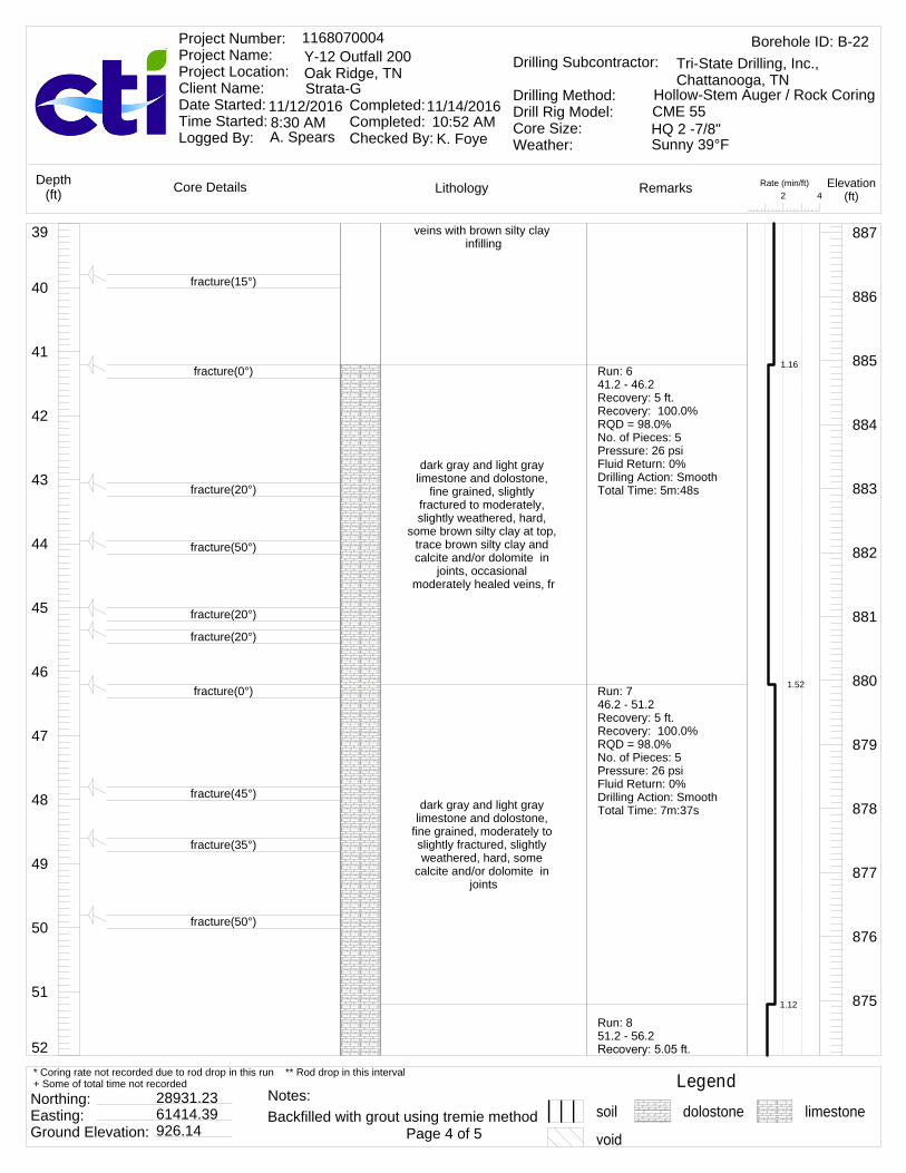
52
51
50
49
48
47
46
45
44
43
42
41
40
39 veins with brown silty clay infilling
dark gray and light gray limestone and dolostone,
fine grained, slightly fractured to moderately, slightly weathered, hard,
some brown silty clay at top, trace brown silty clay and calcite and/or dolomite in
joints, occasional moderately healed veins, fr
dark gray and light gray limestone and dolostone,
fine grained, moderately to slightly fractured, slightly weathered, hard, some
calcite and/or dolomite in joints
887
886
885
884
883
882
881
880
879
878
877
876
875
fracture(15°)
fracture(0°)
fracture(20°)
fracture(50°)
fracture(20°)
fracture(20°)
fracture(0°)
fracture(45°)
fracture(35°)
fracture(50°)
Run: 641.2 - 46.2Recovery: 5 ft.Recovery: 100.0%RQD = 98.0%No. of Pieces: 5Pressure: 26 psiFluid Return: 0%Drilling Action: SmoothTotal Time: 5m:48s
Run: 746.2 - 51.2Recovery: 5 ft.Recovery: 100.0%RQD = 98.0%No. of Pieces: 5Pressure: 26 psiFluid Return: 0%Drilling Action: SmoothTotal Time: 7m:37s
Run: 851.2 - 56.2
1.16
1.52
1.12
Rate (min/ft)42
LithologyCore Details RemarksDepth(ft)
Elevation(ft)
Borehole ID: B-221168070004Y-12 Outfall 200Oak Ridge, TNStrata-G
Project Number: Project Name: Project Location: Client Name: Date Started: Time Started: Logged By:
Completed: Completed: Checked By:
11/12/2016 11/14/2016
A. Spears K. Foye
Drilling Subcontractor:
Drilling Method:Drill Rig Model:Core Size:Weather:
Tri-State Drilling, Inc., Chattanooga, TN
Hollow-Stem Auger / Rock CoringCME 55HQ 2 -7/8"8:30 AM 10:52 AMSunny 39°F
Legendsoil dolostone limestone
Northing: Easting: Ground Elevation:
28931.2361414.39926.14 Page 4 of 5
* Coring rate not recorded due to rod drop in this run ** Rod drop in this interval+ Some of total time not recorded
Backfilled with grout using tremie methodNotes:

60
59
58
57
56
55
54
53
52
dark gray and light gray limestone and dolostone, fine grained, moderately
fractured, slightly weathered, hard, occasional totally healed styolite veins,
trace calcite and/or dolomite, styolite and brown
silty clay in joints
dark gray and light gray limestone and dolostone, fine grained, moderately
fractured, slightly weathered, hard, occasional totally healed styolite veins,
trace calcite and/or dolomite, styolite and brown
silty clay in jointsEnd of boring recovery at
60.2
874
873
872
871
870
869
868
867
fracture(55°)
fracture(0°)
fracture(40°)
fracture(45°)
fracture(50°)
fracture(45°)
fracture(30°)
Recovery: 101.0%RQD = 60.0%No. of Pieces: 4Pressure: 26 psiFluid Return: 0%Drilling Action: SmoothTotal Time: 5m:36s
Run: 956.2 - 60.2Recovery: 4.1 ft.Recovery: 102.5%RQD = 100.0%No. of Pieces: 4Pressure: 26 psiFluid Return: 0%Drilling Action: SmoothTotal Time: 6m:44s
1.68
Rate (min/ft)42
LithologyCore Details RemarksDepth(ft)
Elevation(ft)
Borehole ID: B-221168070004Y-12 Outfall 200Oak Ridge, TNStrata-G
Project Number: Project Name: Project Location: Client Name: Date Started: Time Started: Logged By:
Completed: Completed: Checked By:
11/12/2016 11/14/2016
A. Spears K. Foye
Drilling Subcontractor:
Drilling Method:Drill Rig Model:Core Size:Weather:
Tri-State Drilling, Inc., Chattanooga, TN
Hollow-Stem Auger / Rock CoringCME 55HQ 2 -7/8"8:30 AM 10:52 AMSunny 39°F
Legendsoil dolostone limestone
Northing: Easting: Ground Elevation:
28931.2361414.39926.14 Page 5 of 5
* Coring rate not recorded due to rod drop in this run ** Rod drop in this interval+ Some of total time not recorded
Backfilled with grout using tremie methodNotes:

GEOTECHNICAL REPORT FOR DATA GAP
CHARACTERIZATION AT THE PROPOSED OUTFALL 200
MERCURY TREATMENT FACILITY SITES
January 2017
Appendix B – Geophysical Logging Report

Geophysical Logging Report
Borings B‐2, B‐4, B‐6, B‐7, B‐9, B‐10, B‐11, B‐21,and B‐22
Outfall 200 Mercury Treatment Facility Sites
Y‐12, Oak Ridge, Tennessee
Performed for:
Strata‐G
November 29, 2016
GEL Geophysics LLC Charleston, SC Charlotte, NC Raleigh, NC Atlanta, GA www.gelgeophysics.com

i
GEL Geophysics LLC Charleston, SC Charlotte, NC Raleigh, NC Atlanta, GA www.gelgeophysics.com
Geophysical Logging Report
Borings B‐2, B‐4, B‐6, B‐7, B‐9, B‐10, B‐11, B‐21, and B‐22
Outfall 200 Mercury Treatment Facility Sites
Y‐12, Oak Ridge, Tennessee
TABLE OF CONTENTS
Section Page
Signature Page .................................................................................................................................. ii
Executive Summary ......................................................................................................................... iii
1.0 Introduction ........................................................................................................................... 1
2.0 Equipment and Methodology ................................................................................................ 1
2.1 Mechanical 3‐Arm Caliper ............................................................................................ 1
2.2 Natural Gamma ............................................................................................................ 1
3.0 Field Procedures .................................................................................................................... 2
4.0 Data Processing and Results .................................................................................................. 3
Appendices
Appendix 1 Geophysical Logs
ii
GEL Geophysics LLC Charleston, SC Charlotte, NC Raleigh, NC Atlanta, GA www.gelgeophysics.com
Signature Page
This report, entitled “Geophysical Logging Report, Borings B‐2, B‐4, B‐6, B‐7, B‐9, B‐10, B‐11, B‐21, and B‐22, Outfall 200 Mercury Treatment Facility Sites, Y‐12, Oak Ridge, Tennessee” has been prepared for Strata‐G located in Knoxville, Tennessee. It has been prepared under the supervision of Mr. Jorgen Bergstrom at the request of and the exclusive use of Strata‐G. This report has been prepared in accordance with accepted quality control practices and has been reviewed by the undersigned.
GEL Geophysics, LLC
A Member of the GEL Group, Inc.
Jorgen Bergstrom
Senior Geophysicist
Matthew J. Wolf
Chief Technology Officer
November 29, 2016
Date

iii
GEL Geophysics LLC Charleston, SC Charlotte, NC Raleigh, NC Atlanta, GA www.gelgeophysics.com
Geophysical Logging Report
Borings B‐2, B‐4, B‐6, B‐7, B‐9, B‐10, B‐11, B‐21, and B‐22
Outfall 200 Mercury Treatment Facility Sites
Y‐12, Oak Ridge, Tennessee
EXECUTIVE SUMMARY
GEL Geophysics performed geophysical borehole logging services in nine borings at the Outfall
200 Mercury treatment facility sites at Y‐12, Oak Ridge, Tennessee on November 15‐16, 2016. The
geophysical logs consisted of mechanical 3‐arm caliper and natural gamma. For this investigation, GEL
Geophysics used a Mount Sopris logging system for collecting the data and WellCAD v. 5.1 for analyzing
the data. WellCAD is manufactured by Advanced Logic Technology.
Several boreholes could not be logged to the total depth due to cave‐ins. In a couple of
boreholes, the holes caved in during logging causing differences in the total depth logged with each
tool.
The logging data was analyzed to determine the location and aperture of borehole openings
presumably caused by voids or fractures, and assess if the voids or fractures appear to be open or clay‐
filled. Overall, increases in caliper readings with no corresponding increase in natural gamma reading
were interpreted as possibly open void or fracture. Increases in caliper readings with a corresponding
increase in natural gamma reading were interpreted as possible clay‐filled void or fracture.

GEL Geophysics LLC Charleston, SC Charlotte, NC Raleigh, NC Atlanta, GA www.gelgeophysics.com
Geophysical Logging Report
Borings B‐2, B‐4, B‐6, B‐7, B‐9, B‐10, B‐11, B‐21, and B‐22
Outfall 200 Mercury Treatment Facility Sites
Y‐12, Oak Ridge, Tennessee
1.0 INTRODUCTION
GEL Geophysics performed geophysical borehole logging services in nine borings, at the Outfall
200 Mercury treatment facility sites at Y‐12, Oak Ridge, Tennessee. The geophysical logs consisted of
mechanical 3‐arm caliper and natural gamma. The field investigations were performed on November
15‐16, 2016. The logging data was analyzed to determine the location and aperture of borehole
openings presumably caused by voids or fractures, and assess if the voids or fractures appear to be
open or clay‐filled.
2.0 EQUIPMENT AND METHODOLOGY
The information below is an overview of the geophysical methodologies used for this
investigation. The intent of this overview is to give the reader a better understanding of each method,
and background information as to what is actually measured, the resolution of the method, and the
limitations imposed by site‐specific subsurface conditions.
2.1 Mechanical 3‐arm caliper
Caliper logging is used to generate a profile of the borehole diameter with depth. The tool
measures the borehole diameter using three spring‐loaded arms. Narrow enlargements in the
borehole diameter can, in most cases, be attributed to fractures. Caliper logging can be conducted
above and below the water surface.
2.2 Natural Gamma
Natural gamma tools measure the gamma radiation from the formation. These logs
can be used to discriminate between different formations by utilizing variations in the
concentration of naturally occurring radioactive isotopes such as potassium, uranium and
thorium. These logs are particularly popular for correlating logs and locating clay and
shale formations since radioactive elements tend to concentrate in these materials.
Natural gamma logging can be conducted in cased and uncased boreholes, water‐filled
and dry.

Geophysical Logging Report, Borings B‐2, B‐4, B‐6, B‐7, B‐9, B‐10, B‐11, B‐21, B‐22 November 29, 2016 Outfall 200 Mercury Treatment Facility Sites, Y‐12, Oak Ridge, Tennessee (stra00116) Page 2
GEL Geophysics LLC Charleston, SC Charlotte, NC Raleigh, NC Atlanta, GA www.gelgeophysics.com
3.0 FIELD PROCEDURES
For this investigation, GEL Geophysics used a Mount Sopris logging system for collecting the
data and WellCAD v. 5.1 for analyzing the data. WellCAD is manufactured by Advanced Logic
Technology. The following equipment was used onsite:
Data Acquisition System: Matrix data logger
Logging Winch: MX system with 1,500 feet of cable
Mechanical 3‐arm caliper: QL40‐CAL
Natural Gamma: 2PGA
Several boreholes could not be logged to the total depth due to cave‐ins before or between
logging runs. In a couple of boreholes, the holes caved in during or after logging with one tool
causing differences in the total depth logged with subsequent tools.
A summary of the borehole configurations is provided below. All depth measurements are
referenced from ground surface. All borings were surface cased to the overburden and
bedrock/competent rock interface with an approximately 4‐inch casing and open uncased hole below
the casing.
Logging Configuration Summary
Well ID Borehole diameter (in)* (open hole)
Casing Depth (ft)*
Total depth logged (ft)
Reported total depth (ft)
B‐2 3.5 7.6 58.8 60.0
B‐4 3.5 Appr. 4.6 38.3 60.0
B‐6 3.5 6.9 34.3 60.0
B‐7 3.8 to 46’ 3.5 below 46’
17.5 58.5 (caliper) 40.4 (gamma)
60.0
B‐9 3.8 21.6 51.9 60.0
B‐10 3.8 17.6 50.9 (gamma) 25.6 (caliper)
60.0
B‐11 3.5 20.7 54.3 60.0
B‐21 3.8 to 30’ 3.5 below 30’
18.1 42.7 60.0
B‐22 3.5 17.1 59.7 60.0
*Based on caliper logging

Geophysical Logging Report, Borings B‐2, B‐4, B‐6, B‐7, B‐9, B‐10, B‐11, B‐21, B‐22 November 29, 2016 Outfall 200 Mercury Treatment Facility Sites, Y‐12, Oak Ridge, Tennessee (stra00116) Page 3
GEL Geophysics LLC Charleston, SC Charlotte, NC Raleigh, NC Atlanta, GA www.gelgeophysics.com
4.0 DATA PROCESSING AND RESULTS
Increases in caliper readings with no corresponding increase in natural gamma reading were
interpreted as possibly open void or fracture. Increases in caliper readings with a corresponding
increase in natural gamma reading were interpreted as possible clay‐filled void or fracture. There
was one void or fracture detected in boring B‐7 at a depth where only caliper data was collected
(45.5 feet below ground surface). Without the natural gamma data, it could not be assessed if this
void or fracture was open or clay‐filled. Also, there was one section with increased natural gamma
readings detected in boring B‐10 at a depth where only natural gamma data was collected (38.2 feet
below ground surface). This section was interpreted as possible clay‐filled void or fracture. One
reason for this interpretation is that the natural gamma response looks very similar to the response
at 46.7 feet and 48.5 feet in the adjacent boring B‐9 (where both logs were available). A summary of
the detected voids and fractures are provided below.
B‐2 Depth (ft)
Aperture (mm) Comment
8.1 150 Possibly clay‐filled
9.9 105 Possibly clay‐filled
11.9 80 Possibly clay‐filled
B‐4 Depth (ft)
Aperture (mm) Comment
10.9 250 Possibly clay‐filled
12.0 130 Possibly clay‐filled
14.8 1120 Possibly clay‐filled
B‐6 Depth (ft)
Aperture (mm) Comment
7.5 190 Possibly clay‐filled
11.9 990 Possibly clay‐filled
14.2 140 Possibly clay‐filled
B‐7 Depth (ft)
Aperture (mm) Comment
17.9 150 Possibly clay‐filled
33.7 550 Possibly open
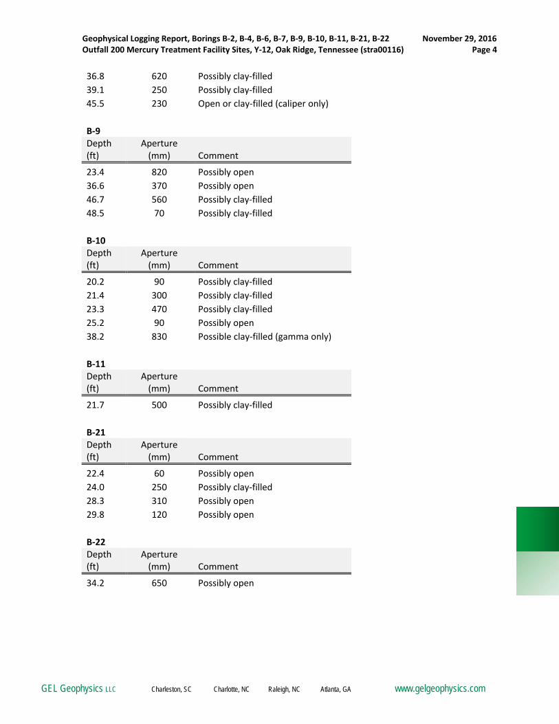
Geophysical Logging Report, Borings B‐2, B‐4, B‐6, B‐7, B‐9, B‐10, B‐11, B‐21, B‐22 November 29, 2016 Outfall 200 Mercury Treatment Facility Sites, Y‐12, Oak Ridge, Tennessee (stra00116) Page 4
GEL Geophysics LLC Charleston, SC Charlotte, NC Raleigh, NC Atlanta, GA www.gelgeophysics.com
36.8 620 Possibly clay‐filled
39.1 250 Possibly clay‐filled
45.5 230 Open or clay‐filled (caliper only)
B‐9 Depth (ft)
Aperture (mm) Comment
23.4 820 Possibly open
36.6 370 Possibly open
46.7 560 Possibly clay‐filled
48.5 70 Possibly clay‐filled
B‐10 Depth (ft)
Aperture (mm) Comment
20.2 90 Possibly clay‐filled
21.4 300 Possibly clay‐filled
23.3 470 Possibly clay‐filled
25.2 90 Possibly open
38.2 830 Possible clay‐filled (gamma only)
B‐11 Depth (ft)
Aperture (mm) Comment
21.7 500 Possibly clay‐filled
B‐21 Depth (ft)
Aperture (mm) Comment
22.4 60 Possibly open
24.0 250 Possibly clay‐filled
28.3 310 Possibly open
29.8 120 Possibly open
B‐22 Depth (ft)
Aperture (mm) Comment
34.2 650 Possibly open

APPENDIX 1

Depth
1ft:100ft
Caliper
3 6in
Natural Gamma
0 200cpsFractures and voids
0.0
2.0
4.0
6.0
8.0
10.0
12.0
14.0
16.0
18.0
20.0
22.0
24.0
26.0
28.0
30.0
32.0
34.0
36.0
38.0
40.0
42.0
44.0
46.0
48.0
50.0
52.0
54.0
56.0
58.0
60.0
62.0
64.0
66.0
68.0
70.0
72.0
74.0
76 0
Bottom of casing
Boring ID: B-2
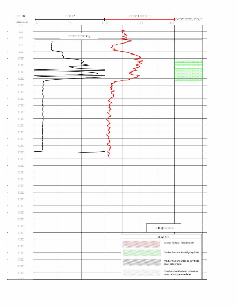
Depth
1ft:100ft
Caliper
3 6in
Natural Gamma
0 200cpsFractures and Voids
0.0
2.0
4.0
6.0
8.0
10.0
12.0
14.0
16.0
18.0
20.0
22.0
24.0
26.0
28.0
30.0
32.0
34.0
36.0
38.0
40.0
42.0
44.0
46.0
48.0
50.0
52.0
54.0
56.0
58.0
60.0
62.0
64.0
66.0
68.0
70.0
72.0
74.0
76 0
Bottom of casing
Boring ID: B-4

Depth
1ft:100ft
Caliper
3 6in
Natural Gamma
0 200cpsFractures and voids
0.0
2.0
4.0
6.0
8.0
10.0
12.0
14.0
16.0
18.0
20.0
22.0
24.0
26.0
28.0
30.0
32.0
34.0
36.0
38.0
40.0
42.0
44.0
46.0
48.0
50.0
52.0
54.0
56.0
58.0
60.0
62.0
64.0
66.0
68.0
70.0
72.0
74.0
76 0
Bottom of casing
Boring ID: B-6

Depth
1ft:100ft
Caliper
3 6in
Natural Gamma
0 200cpsFractures and voids
0.0
2.0
4.0
6.0
8.0
10.0
12.0
14.0
16.0
18.0
20.0
22.0
24.0
26.0
28.0
30.0
32.0
34.0
36.0
38.0
40.0
42.0
44.0
46.0
48.0
50.0
52.0
54.0
56.0
58.0
60.0
62.0
64.0
66.0
68.0
70.0
72.0
74.0
76 0
Bottom of casing
Boring ID: B-7

Depth
1ft:100ft
Caliper
3 6in
Natural Gamma
0 200cpsFractures and voids
0.0
2.0
4.0
6.0
8.0
10.0
12.0
14.0
16.0
18.0
20.0
22.0
24.0
26.0
28.0
30.0
32.0
34.0
36.0
38.0
40.0
42.0
44.0
46.0
48.0
50.0
52.0
54.0
56.0
58.0
60.0
62.0
64.0
66.0
68.0
70.0
72.0
74.0
76 0
Bottom of casing
Boring ID: B-9

Depth
1ft:100ft
Caliper
3 6in
Natural Gamma
0 200cpsFractures and voids
0.0
2.0
4.0
6.0
8.0
10.0
12.0
14.0
16.0
18.0
20.0
22.0
24.0
26.0
28.0
30.0
32.0
34.0
36.0
38.0
40.0
42.0
44.0
46.0
48.0
50.0
52.0
54.0
56.0
58.0
60.0
62.0
64.0
66.0
68.0
70.0
72.0
74.0
76 0
Bottom of casing
Boring ID: B-10
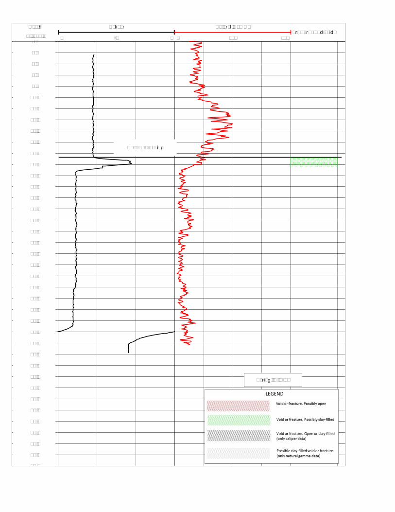
Depth
1ft:100ft
Caliper
3 6in
Natural Gamma
0 200cpsFractures and voids
0.0
2.0
4.0
6.0
8.0
10.0
12.0
14.0
16.0
18.0
20.0
22.0
24.0
26.0
28.0
30.0
32.0
34.0
36.0
38.0
40.0
42.0
44.0
46.0
48.0
50.0
52.0
54.0
56.0
58.0
60.0
62.0
64.0
66.0
68.0
70.0
72.0
74.0
76 0
Bottom of casing
Boring ID: B-11

Depth
1ft:100ft
Caliper
3 6in
Natural Gamma
0 200cpsFractures and voids
2.0
4.0
6.0
8.0
10.0
12.0
14.0
16.0
18.0
20.0
22.0
24.0
26.0
28.0
30.0
32.0
34.0
36.0
38.0
40.0
42.0
44.0
46.0
48.0
50.0
52.0
54.0
56.0
58.0
60.0
62.0
64.0
66.0
68.0
70.0
72.0
74.0
76 0
Bottom of casing
Boring ID: B-21

Depth
1ft:100ft
Natural Gamma
0 200cps
Caliper
3 6inFractures and voids
0.0
2.0
4.0
6.0
8.0
10.0
12.0
14.0
16.0
18.0
20.0
22.0
24.0
26.0
28.0
30.0
32.0
34.0
36.0
38.0
40.0
42.0
44.0
46.0
48.0
50.0
52.0
54.0
56.0
58.0
60.0
62.0
64.0
66.0
68.0
70.0
72.0
74.0
76 0
Bottom of casing
Boring ID: B-22
GEOTECHNICAL REPORT FOR DATA GAP
CHARACTERIZATION AT THE PROPOSED OUTFALL 200
MERCURY TREATMENT FACILITY SITES
January 2017
Appendix C – Boring Location Plan

Geotechnical Report Proposed Mercury Treatment Facility Site (Y-12 Outfall 200 Facility) Final Report, January 2017
AS‐BUILT SURVEY GEOTECHNICAL SOIL BORINGS
Y12 OUTFALL 200 MERCURY TREATMENT FACILITY
12/1/2016
Borehole ID Y‐12 Grid Easting (ft)
Y‐12 Grid Northing (ft)
Elevation (ft amsl)
B‐1 57771.7 29296.3 935.55
B‐2 57808.5 29291.3 935.18
B‐3 57836.8 29286.1 935.69
B‐4 57900.5 29279.8 935.63
B‐5 57740.1 29254.6 937.38
B‐6 57758.7 29262.7 935.62
B‐7 57760.8 29234.8 936.00
B‐8 57781.9 29268.1 935.13
B‐9 57800.4 29233.0 935.62
B‐10 57820.8 29244.0 935.67
B‐11 57837.2 29253.3 935.46
B‐12 57854.7 29211.8 935.70
B‐14 57926.3 29209.3 935.75
B‐15 61392.9 29008.9 926.38
B‐16 61431.3 28993.8 926.58
B‐17 61461.9 29014.2 926.39
B‐18 61465.8 28974.8 926.34
B‐19 61555.5 29007.9 926.37
B‐20 61531.3 28928.6 926.04
B‐21 61385.1 28961.0 926.43
B‐22 61414.4 28931.2 926.14
ft = feet amsl = above mean sea level Final, completed boring locations were surveyed to the nearest 0.05-ft. amsl as-built elevation and 0.1-ft. horizontally using Y-12 coordinates. Y-12 control point 176 was used for vertical control (NAVD29 datum). Survey performed by Barge Waggoner Sumner & Cannon, Knoxville, Tennessee on December 1, 2016
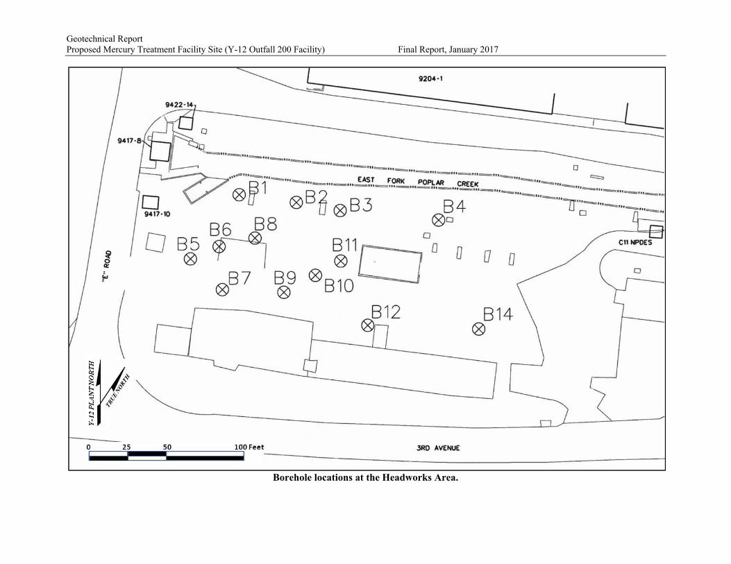
Geotechnical Report Proposed Mercury Treatment Facility Site (Y-12 Outfall 200 Facility) Final Report, January 2017
Borehole locations at the Headworks Area.

Geotechnical Report Proposed Mercury Treatment Facility Site (Y-12 Outfall 200 Facility) Final Report, January 2017
Borehole locations at the Outfall 200 Mercury Treatment Facility Area.

GEOTECHNICAL REPORT FOR DATA GAP
CHARACTERIZATION AT THE PROPOSED OUTFALL 200
MERCURY TREATMENT FACILITY SITES
January 2017
Appendix D – General Notes for Soil/Rock Classification

Protecting, Enhancing, and Restoring Our Environment
GENERAL NOTES FOR SOIL/ROCK CLASSIFICATION
GROUNDWATER: Observations, if any, are made at the times indicated on logs. Porosity of soil strata, weatherconditions and site topography may cause changes in the water levels.
SOIL CLASSIFICATION PROCEDURE: Classification on the logs is generally made by visual inspection. Forfine-grained soils (silt, clay and combinations thereof), the classification is primarily based upon plasticity. Forcoarse-grained soils (sand and gravel), the classification is based upon particle size distribution. Minor soilconstituents are reported as “trace” (0-5%), “some” (5-12%) and “with” (15-29%). Where the minor constituentsare in excess of 29%, an adjective is used preceding the major constituent name (i.e. for sands containing 35%silt, the soil is classified as silty sand). In some cases, consistency terms such as very soft, soft, medium stiff,stiff, very stiff, or hard may be used to describe cohesive soils (silt and clay), terms such as very loose, loose,medium dense, dense, or very dense may be used to describe cohesionless soils (sand). For the purposes ofdescribing infilling, these consistency terms are relative, and not based on Standard Penetration Resistances (N)or unconfined compressive strength tests.
PARTICLE SIZE DISTRIBUTIONBoulders Greater than 12 inches average diameter
Cobbles 3 inches to 12 inchesGravel No. 4 (4.75mm) to 3 inchesSand No. 200 (0.075mm) to No. 4 (4.75mm)Silt 0.005mm to 0.075mmClay size is less than 0.005mm
ROCK CLASSIFICATION PROCEDURE: Classification on the logs is generally made by visual inspection.However, information about local geologic formations can also be used to confirm classifications. Sedimentary,igneous, and metamorphic rock are determined by their color, texture, structure, particle shape and size, mineralcomposition, cement/matrix, and properties during inspection and/or testing. The occurrence of cementing veinsis reported as “occasional” for one or less per foot of depth and “frequent” for more than one per foot of depth.
ROCK CORE EVALUATIONFracture Density Rock Hardness Rock Quality (RQD)
Unfractured 0 fractures perrun Very Soft Deformed by hand, scratched
with a fingernailVeryPoor RQD < 25%
Slightlyfractured spacing > 2 ft Soft Scratched with a fingernail,
crumbles with geologic pick Poor 25% < RQD < 50%
Moderatelyfractured
8 in < spacing< 2 ft
ModeratelyHard
Scratched easily with a knife orsteel nail Fair 50% < RQD < 75%
Highlyfractured
2 in < spacing< 8 in Hard Broken with one hammer blow,
difficulty scratching with knife Good 75% < RQD < 90%
Intenselyfractured spacing < 2 in Very Hard
Broken with several hammerblows, cannot be scratchedwith knife or steel nail
Excellent 90% < RQD < 100%
Degree of Weathering Fracture Healing
Unweathered No evidence of any chemical ormechanical alteration
Totally HealedVeins Fracture re-cemented
SlightlyWeathered
Slight discoloration on surface, slightalteration at fractures, less than 10percent of rock volume altered
ModeratelyHealed Veins
Greater than 50% of fracture materialre-cemented
ModeratelyWeathered
Moderate discoloring, 10 percent to 50percent of rock volume altered
Partly HealedVeins
Less than 50% of fracture material re-cemented
HighlyWeathered
Highly discolored, more than 50percent of rock volume altered Open Joint
Fracture without cementation, rockdoes not fit together with adjacentcore pieces without open spaces


