

1
District Irrigation Plan, 2015-2020
Sirmour, Himachal Pradesh
NABARD CONSULTANCY SERVICES PVT. LTD.
Corporate Office : 24, Rajendra Place, NABARD Building, New Delhi – 110125
Reg. Office : Plot No. C24, G Block, 3rd Floor, NABARD Building
Bandra Kurla Complex, Bandra East, Mumbai-400051
2
3
CONTENTS
Executive summary ............................................................................................................. 8
INTRODUCTION ............................................................................................................... 1
Background ....................................................................................................................... 1
Vision ................................................................................................................................. 7
Objective ........................................................................................................................... 7
Strategy/approach ............................................................................................................ 8
Programme Components .................................................................................................. 9
Rationale/ Justification ................................................................................................... 11
Methodology ................................................................................................................... 11
Chapter 1. General Information of the District .......................................................... 13
1.1 District Profile............................................................................................................ 13
1.2 Demography .............................................................................................................. 18
1.3 Biomass and Livestock .............................................................................................. 21
1.4 Agro-Ecology, Climate, Hydrology and Topography ................................................. 23
1.5 Soil Profile ................................................................................................................. 28
1.6 Soil Erosion and Runoff Status .................................................................................. 30
1.7 Land Use Pattern ....................................................................................................... 31
Chapter 2. District Water Profile ................................................................................. 36
2.1 Area Wise, Crop Wise Irrigation Status ..................................................................... 36
2.2 Production and Productivity of Major Crops ............................................................ 37
2.3 Irrigation Based Classification ................................................................................... 38
Chapter 3. Water Availability in Sirmour ................................................................... 40
3.1 Status of Water Availability ....................................................................................... 40
3.2 Status of Ground Water Availability ......................................................................... 43
3.3 Status of Command Area .......................................................................................... 49
3.4 Existing Type of Irrigation ......................................................................................... 50
Chapter 4. Water Requirement /Demand .................................................................... 52
4.1 Domestic Water Demand .......................................................................................... 52
4.2 Crop Water Requirement .......................................................................................... 53
4.3 Livestock .................................................................................................................... 55

4
4.4 Industrial Water Requirement .................................................................................. 56
4.5 Water Demand for Power Generation ...................................................................... 57
4.6 Total Water Demand of the district for various sectors ........................................... 58
4.7 Water Budget ............................................................................................................ 59
Chapter 5. Strategic Action Plan for Irrigation in District under PMKSY ............. 60
5.5.1 Year wise total Plan of the district: ........................................................................ 61
5.5.2 Component wise Plan ............................................................................................ 63
5.3 Suggestions ............................................................................................................... 79
5.6 Expected Outcome .................................................................................................... 80
Annexure –V: Strategic Action Plan for irrigation in respect of District Sirmour under
Pradhan Mantri Krishi Sinchayee Yojna (PMKSY) ........................................................... 82

5
LIST OF TABLES
Table 1.1: District Profile ............................................................................................................................. 14
Table 1.2: Demography of Sirmour district ................................................................................................. 18
Table 1.3: Distribution of SC, ST and general population in the district ..................................................... 19
Table 1.4: Distribution of SC, ST and general household in the district ..................................................... 20
Table 1.5: Population of small animals (livestock) in Sirmour .................................................................... 21
Table 1.6: Population of large animals (Livestock) in Sirmour .................................................................... 22
Table 1.7: Agro-Ecology, Climate, Hydrology and Topography .................................................................. 25
Table 1.8: Relative humidity in Sirmour during different months .............................................................. 26
Table 1.9: Soil Profile of the district ............................................................................................................ 29
Table 1.10: Problems and Intervention for Land Development (Per Cent of Panchayats) ......................... 31
Table 1.11: Land use pattern ...................................................................................................................... 31
Table 2.1: Area Wise, Crop Wise irrigation Status ...................................................................................... 36
Table 2.2: Production and Productivity of Major Crops ............................................................................. 38
Table 2.3: Irrigation based classification ..................................................................................................... 39
Table 3.1: Status of water availability ......................................................................................................... 42
Table 3.2: Status of ground water availability ............................................................................................ 47
Table 3.3: Status of command area ............................................................................................................ 50
Table 3.4: Existing type of irrigation (Surface water) ................................................................................. 51
Table 4.1: Domestic Water Demand (MCM)............................................................................................... 53
Table 4.2: Crop Water Requirement in Million Cubic Meter ...................................................................... 54
Table 4.3: Livestock water requirement ..................................................................................................... 55
Table 4.4: Industrial Water Demand in MCM ............................................................................................. 57
Table 4.5: Water Demand for Power Generation ....................................................................................... 58
Table 4.6a: Present Water Demand of the district for various sectors ...................................................... 58
Table 4.7: Water Budget (Volume in MCM) ............................................................................................... 59
Table 5.1: Block wise plan of the district .................................................................................................... 61
Table 5.2: Department wise, Year wise PMKSY Plan .................................................................................. 62
Table 5.3: Component wise plan ................................................................................................................ 63
Table 5.4: Block Nahan................................................................................................................................ 69
Table 5.5: Block Paonta Sahib ..................................................................................................................... 71
Table 5.6: Block Pachhad ............................................................................................................................ 72
Table 5.7: Block Rajgarh .............................................................................................................................. 74
Table 5.8: Block Sangrah ............................................................................................................................. 76
Table 5.9: Shillai Block ................................................................................................................................. 78

6
LIST OF FIGURES
Figure 1.1: Administrative setup of Sirmour ............................................................................................... 15
Figure 1.2: Demography of Sirmour............................................................................................................ 19
Figure 1.3: Distribution of SC, ST and General population in the district ................................................... 19
Figure 1.4: Distribution of SC, ST and general households in the district ................................................... 20
Figure 1.5: Change in population of animals in Sirmour............................................................................. 23
Figure 1.6: Block wise total geographical area ........................................................................................... 32
Figure 1.7: Share of blocks in Gross Cropped Area ..................................................................................... 33
Figure 1.8: Block-wise area under forest in comparison to Total Geographical Area ................................ 34
Figure 2.1: Irrigated area under cultivation during Kharif & Rabi .............................................................. 36
Figure 4.1: Current and Projected Population in various blocks of Sirmour .............................................. 52
Figure 4.2: Present and projected water requirement in MCM ................................................................. 53
Figure 4.3: Crop water requirement in MCM ............................................................................................. 54
Figure 4.4: Livestock water requirement in MCM ...................................................................................... 56
Figure 4.5: Current and projected water requirement of various sectors ................................................. 59
Figure 5.1: Year wise, department wise PMKSY Plan of Sirmour district (Rs .in Lakh) ............................... 62
Figure 5.2: Stakeholders of PMKSY in Sirmour District ............................................................................ 63
Figure 5.3: Year wise component wise plan of Sirmour District (Amount Rs. in Lakh) .............................. 64
Figure 5.4: Share of different components of PMKSY ................................................................................ 64
Figure 5.5: Year wise component wise plan of Nahan Block (Amt. Rs. in lakh) .......................................... 70
Figure 5.6: Stakeholders of PMKSY in Nahan Block .................................................................................... 70
Figure 5.7: Year wise component wise plan of Paonta Sahib Block (Rs. In lakh) ........................................ 71
Figure 5.8: Stakeholders of PMKSY in Paonta Sahib Block ......................................................................... 72
Figure 5.9: Year-wise and Department wise Plan for Block Pachhad (Rs. in lakh) ..................................... 73
Figure 5.10: Share of stakeholders in Pachhad block ................................................................................. 73
Figure 5.11: Year-wise and Department wise Plan for Block Rajgarh (Rs. in lakh) ..................................... 75
Figure 5.12: Year-wise and Department wise Plan for Block Rajgarh (Rs. in lakh) ..................................... 75
Figure 5.13: Year-wise and Department wise Plan for Block Sangrah (Rs. in lakh) .................................... 76
Figure 5.14: Share of stakeholders in Sangrah Block .................................................................................. 77
Figure 5.15: Year wise and Department wise Plan for Block Shillai (Amt. Rs. in lakh) ............................... 78
Figure 5.16: Share of stakeholders in Shillai Block ..................................................................................... 79

7
LIST OF MAPS
Map 1.1: District Map of Sirmour ............................................................................................................... 13
Map 1.2: Soil map of Sirmour ..................................................................................................................... 30
Map 1.3: LULC change of Sirmour (2016) ................................................................................................... 34
Map 1.4: LULC change of Sirmour (2000) ................................................................................................... 35
Map 3.1: Hydrogeology map of Sirmour .................................................................................................... 44
Map 3.2: Depth to Water level (May 2012) ................................................................................................ 46
Map 3.3: Depth of water level (Nov 2012) ................................................................................................. 46
Map 3.4: Ground Water User map ............................................................................................................. 48

8
Executive summary
In an agrarian economy like India, agriculture utilizes the major share of country’s exploitable
water resources. Though the sector utilizes the maximum share of exploitable water resources,
availability of the same at different locations to different extent makes it vital to adopt effective
utilization of water through storage, channelizing and judicial use. At some places like Punjab and
Haryana, the environmental and socio-economic rationale for this capture by the sector is now
being questioned. Accordingly, it is needed to challenge and change the fundamentals of the
prevailing view of water resources exploitation. A new and more suitable approach to water
resources allocation is necessary if the population is to be adequately fed, without further
degradation and destruction of the critical ecosystem services. Water productivity needs to be
enhanced considerably, and economic cost-benefit analysis and pricing regimes can play a
significant role in such a process. However, these economic measures will not be sufficient on
their own. They will need to be buttressed by technological innovation and institutional changes
in order to encourage a more equitable distribution of resources and to mitigate potential
international conflicts across 'shared' water basins.
Water has unique characteristics that determine both its allocation and use as a resource by
agriculture. Agricultural use of water for irrigation is itself contingent on land resources. In a
situation of growing water scarcity and rising demands for non-agricultural (household and
industrial) use of water, reassessment of sectoral allocations of water are inevitable. In developing
countries, irrigated agriculture plays a vital role in contributing towards domestic food security
and poverty alleviation. Therefore, achievement of these objectives is dependent on adequate
allocations of water to agriculture. Justification of such allocations requires that irrigated
agriculture be a cost-effective means of achieving stated political or social objectives, such as food
security or poverty alleviation, and that all externalities be taken into account in the pricing
mechanism. Improved allocation of irrigation water is required within the agriculture sectors in
order to achieve greater efficiency in the use of irrigation water and existing irrigation
infrastructure. Reallocation is also required in order to reduce waterlogging and salinization of
irrigated land, to decrease the negative environmental impacts and other externalities of irrigation
(caused by over extraction of groundwater and depletion and pollution of surface water).

9
Government of India launched Pradhan Mantri Krishi Sinchayee Yojana (PMKSY) to address the
constraints in providing assured irrigation as well as increasing efficiency and productivity of
current water use to bring more prosperity to the rural areas. Priorities of Government of India
were reflected in the Hon’ble President’s address to the joint Session of the Parliament of 16th
Lok Sabha where he indicated that “Each drop of water is precious. Government is committed to
giving high priority to water security. It will complete the long pending irrigation projects on
priority and launch the ‘Pradhan Mantri Krishi Sinchayee Yojana’ with the motto of ‘Har Khet Ko
Pani’. There is a need for seriously considering all options including linking of rivers, where
feasible; for ensuring optimal use of our water resources to prevent the recurrence of floods and
drought. By harnessing rain water through ‘Jal Sanchay’ and ‘Jal Sinchan’, we will nurture water
conservation and ground water recharge. Micro irrigation will be popularised to ensure ‘Per drop-
More crop”.
PMKSY has been approved with an indicative outlay of Rs.50,000 crore over a period of five years
from 2015-16 to 2019-20. The programme is an amalgamation of on-going schemes of Ministry
of Water Resources, River Development and Ganga Rejuvenation, Ministry of Agriculture &
Cooperation and Ministry of Rural Development. The existing schemes AIBP, CADWM, MI,
SWMA, Watershed & Convergence with MGNREGA were brought together under the umbrella
program of PMKSY. Further the scheme seeks convergence with scheme like Mahatma Gandhi
National Rural Employment Guarantee Scheme (MGNRES), Rashtriya Krishi Vikas Yojana
(RKVY), Jawaharlal Nehru National Solar Mission and Rural Electrification programmes
(JLNNSM&REP), Rural Infrastructure Development Fund (RIDF), Members of Parliament Local
Area Development Scheme (MPLAD), Members of Legislative Assembly Local Area
Development Fund (MLALAD), Local Body Funds (LBF), Working Plan of State Forest
Department (WPSFD) etc. The PMKSY will be implemented in an area development mode only
by adopting a decentralized state level planning and projectised execution structure that will allow
the state to draw up their own irrigation development plans based on DIPs and SIPs with a horizon
of 5-7 years. The program will be supervised and coordinated utilizing the existing mechanism
and structure available under Rashtriya Krishi Vikas Yojana (RKVY) program with state
agriculture department acting as the State Nodal Agency for implementation of PMKSY.
However, the implementing departments for the four components like AIBP, PMKSY (Har Khet

10
Ko Pani), PMKSY (Per drop more crop) and PMKSY (watershed development) will be decided
by the respective program ministry/department.
The 05 chapters along with introduction chapter, explains the profile of district, its water
requirement for agriculture and allied sector, water availability, assessment of water requirement
for various sectors and strategic action plan for augmentation and effective management of
available water resources.
District Demography: Sirmour is the most south-eastern district of Himachal Pradesh. It shares
its boundaries with Haryana in the west and south and Uttarkhand in the east. The Latitude and
Longitude of Sirmour Himachal Pradesh is 30°22'30" to 31°01'20" North and 77° 01'12" to
77°49'40" East respectively. The district is predominantly mountainous with deep valleys lying
between Shivalik ranges of varying elevations. As per 2011 census, the total population of the
district is 5,29,855 out of which population of female and male are 2,53,566 and 2,76,289
respectively. Sirmour district is the 5th smallest in population in the state. District is predominantly
rural and around 89.2% of the population resides in rural area.
Agriculture in Sirmour: The gross irrigated area in the district is 24,630 hectare which is 33.6%
of the 73,335 of gross cropped area. The extent of irrigated land in gross cropped area in both
Kharif and Ravi is to the tune of 33.6%, with a small variation in gross cropped area. In Kharif,
the gross cropped area is 39,635 hectare while during Rabi, the gross cropped area is 33,700
hectare. In case of Horticultural and Plantation crops, the irrigated area is to the extent of 28% of
the total area covered under this category of crops.
Maize, paddy & wheat are main crops grown in Sirmour district by farmer who have comparatively
larger land holding. Pulses & oilseeds are grown on marginal lands as mixed crop. However, in
some cases, it has also been observed that the pulses & Oilseeds are grown as sole crop also.
Vegetable and cash crops are grown on limited scale in the district. Horticultural farming is carried
out as back yard enterprise. Mango, Kinnow, Lime, Litchi, Guava are some of the fruits which are
grown in the district.
Among fruits crops, Mango is the major fruit produced in the district. The total production of
Mango in the district is to the tune of 3.6 thousand MT while the production of Mango is to the
tune of 2.1 thousand MT. Potato and Ginger are among the commonly cultivated vegetable crops
11
in the district. The total production of Potato in Sirmour is 16 thousand MT with a productivity of
11785 kg per hectare.
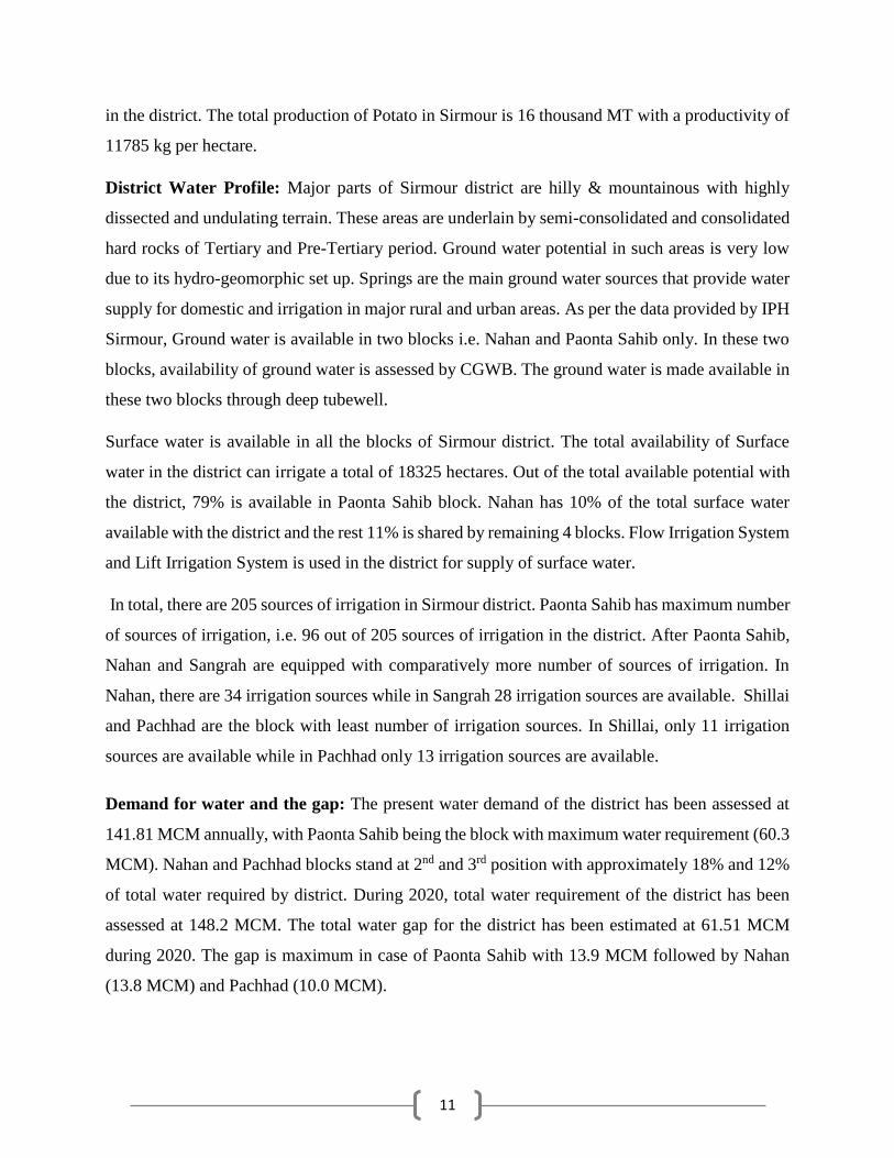
District Water Profile: Major parts of Sirmour district are hilly & mountainous with highly
dissected and undulating terrain. These areas are underlain by semi-consolidated and consolidated
hard rocks of Tertiary and Pre-Tertiary period. Ground water potential in such areas is very low
due to its hydro-geomorphic set up. Springs are the main ground water sources that provide water
supply for domestic and irrigation in major rural and urban areas. As per the data provided by IPH
Sirmour, Ground water is available in two blocks i.e. Nahan and Paonta Sahib only. In these two
blocks, availability of ground water is assessed by CGWB. The ground water is made available in
these two blocks through deep tubewell.
Surface water is available in all the blocks of Sirmour district. The total availability of Surface
water in the district can irrigate a total of 18325 hectares. Out of the total available potential with
the district, 79% is available in Paonta Sahib block. Nahan has 10% of the total surface water
available with the district and the rest 11% is shared by remaining 4 blocks. Flow Irrigation System
and Lift Irrigation System is used in the district for supply of surface water.
In total, there are 205 sources of irrigation in Sirmour district. Paonta Sahib has maximum number
of sources of irrigation, i.e. 96 out of 205 sources of irrigation in the district. After Paonta Sahib,
Nahan and Sangrah are equipped with comparatively more number of sources of irrigation. In
Nahan, there are 34 irrigation sources while in Sangrah 28 irrigation sources are available. Shillai
and Pachhad are the block with least number of irrigation sources. In Shillai, only 11 irrigation
sources are available while in Pachhad only 13 irrigation sources are available.
Demand for water and the gap: The present water demand of the district has been assessed at
141.81 MCM annually, with Paonta Sahib being the block with maximum water requirement (60.3
MCM). Nahan and Pachhad blocks stand at 2nd and 3rd position with approximately 18% and 12%
of total water required by district. During 2020, total water requirement of the district has been
assessed at 148.2 MCM. The total water gap for the district has been estimated at 61.51 MCM
during 2020. The gap is maximum in case of Paonta Sahib with 13.9 MCM followed by Nahan
(13.8 MCM) and Pachhad (10.0 MCM).

Proposed plan
Har Khet Ko Pani components is to be executed mainly by Irrigation and Public Health
Department. Har Khet Ko Pani component of PMKSY works out to be Rs. 73680.39 Lakh.
Besides, Agriculture and Horticulture department shall also execute some programme under Har
Khet Ko Pani Component. NABARD schemes shall also be executed by I&PH Department
covering Har Khet Ko Pani component. Per drop more crop (Micro irrigation) component will be
executed by Agriculture and Horticulture Departments. Per drop more crop (Supplementary water
management activities) shall be executed by Agriculture Department. Extension & training
component will be covered by ATMA and the component has been included in Per Drop More
Crop. Water shed component will be taken care of by the Rural Development Department. In
Sangrah block programme for convergence under MGNAREGA has also been proposed.
However, all the stakeholders need to have coordination among themselves to have the maximum
irrigation efficiency and to avoid duplicity. Maximum share of 73% amounting to Rs. 73680.39
Lakh is for Har Khet ko Pani followed by Per drop more crop about 17.08% (MI-8.43%, Sup.
Water Mgt- 8.31% and ATMA-0.33%). Watershed activities constitute 3.88% of the plan
amounting to Rs. 3668.04 lakh. The amount for convergence with MGNREGS is Rs. 1086.0 lakh.
Plan Component 2016-17 2017-18 2018-19 2019-20 Total
Accelerated Irrigation Benefit Programme 0.00 0.00 0.00 0.00 0.00
Har Khet Ko Pani 18664.39 19296.67 15957.19 19762.14 73680.39
Per drop more crop (Total) 4037.77 4037.77 4037.83 4037.83 16151.20
i) Micro irrigation 1994.52 1994.52 1994.55 1994.55 7978.14
ii) Supplementary water management activities 1964.99 1964.99 1965.02 1965.02 7860.02
iii) Extension & Training by ATMA 78.27 78.27 78.27 78.27 313.08
PMKSY Watershed 917.01 917.01 917.01 917.01 3668.04
Convergence with MGNREGS 271.50 271.50 271.50 271.50 1086.00
Total 23890.67 24522.95 21183.53 24988.48 94585.63

1
INTRODUCTION
Background
Preparation of decentralized area specific district planning process visualized in various plans took
concrete shape through the years and initiatives like specific guidelines on methodologies and
processes for preparation of district plans; framework for preparation of perspective plan, medium
term and annual plans by then planning commission in 1969 and the 73rd and 74th constitutional
amendments conferring constitutional status to Panchayats at district and sub district level; local
self-government in urban areas; constitution of district planning committee to consolidate the plans
prepared at Panchayats and municipalities and prepare a draft development plan for the whole
district.
The decentralized planning process was further strengthened through emphasis by planning
commission on preparation of district level plans and making it an integral part of the process of
preparation of the states 11th five year plan. The Planning commission issued guidelines in August
2006 for preparation of the district plans. The guidelines define the District Planning as ‘the
process of preparing an integrated plan for the local government sector in a district taking into
account the resources (natural, human and financial) available and covering the sectoral activities
and schemes assigned to the district level and below and those implemented through local
governments in a state. The document that embodies this statement of resources and their
allocation for various purposes is known as the District Plan”.
Government of India through a resolution in National Development Council on 29th May 2007
conceived a special Additional Central Assistance Scheme (ACAS) to address the slow growth of
agriculture and allied sectors by incentivizing states to draw up plans for their agriculture sectors
more comprehensively. The NDC resolution states "GoI will introduce a new Additional Central
Assistance Scheme to incentivize states to draw up plans for their agriculture sector more
comprehensively, taking agro-climatic conditions, natural resource issues and technology into
account, and integrating livestock, poultry and fisheries, etc. This will involve a new scheme for
Additional Central Assistance (ACA) to State Plans, administered by the Union Ministry of
Agriculture over and above its existing Centrally Sponsored Schemes, to supplement the State-

2
specific strategies including special schemes for beneficiaries of land reforms. The newly created
National Rainfed Area Authority will, on request, assist States in planning for rainfed areas".
The NDC in its resolution advised the states to prepare a comprehensive district agriculture plans
(C-DAP) that will fully utilize available resources and will include allied agriculture sectors.
Further, GOI issued a manual on preparation of comprehensive district agriculture plans to help
the states prepare C-DAP. As per these guidelines, the objective of district planning is ‘to design
an integrated and participatory action plan for the development of local area in general and
agriculture and allied sectors in particular’. The objectives of Comprehensive District Agriculture
Plan (C-DAP) are:
To prepare a Comprehensive District Agriculture Plan (C-DAP) through participatory
process involving various organisations and stakeholders.
To enable optimum utilisation of scarce natural, physical & financial resources.
To assess and plan for the infrastructure required to support the agriculture development.
To establish linkages with the required institutional support services, like credit,
technology transfer, ICT, research etc.
To evolve an action plan for achieving sustainable agricultural growth with food security
and cropping system that will improve farmers’ income.
The guidelines required the state/district authorities to (i) ensure that the agricultural plans are
prepared for the district and then integrated into the agricultural plans of the State based on the
agro-climatic conditions, availability of technology, trained manpower and natural resources; (ii)
local needs / crops / feed and fodder / animal husbandry / dairying / fisheries / priorities are
reflected in the plan; (iii) productivity gaps for important crops and livestock and fisheries are
reduced; and (iv) the returns to the farmers from these are maximized.
The latest move in the process of strengthening of decentralized planning process was the
Government of India guidelines issued in 2015 in the form of a template for the preparation of
District Irrigation Plan (DIP) and State Irrigation Plan (SIP) as part of the Pradhan Mantri Krishi
Sinchayee Yojana (PMKSY) program and made the preparation of DIP and SIP mandatory for the
states to receive funds from the program. The present report is a product of these long drawn efforts

3
of Government of India to strengthen the decentralized planning process in the country focusing
on the vital resource i.e., water.
Water is of vital importance for human & animal life, maintenance of ecological balance and
promotion of developmental activities. Considering its vital importance and ever increasing
demand for water, in the face of population growth, urbanization & industrialization and
considerations of climatic change, making water, an increasingly a scarce resource, available to
multiple uses, planning and management of this vital resources, utilization of water economically,
optimally and equitably assumes greater importance.
According to the 12th Five year Plan the water budget estimates of India by Ministry of Water
Resources suggests an availability of 1123 billion cubic meters (BCM) against a current estimated
demand of 710 BCM. The Standing Committee of the Ministry of Water Resources estimates that
this water demand will rise to 1093 BCM by 2025. Though the existing water availability in the
immediate future seems to be adequate, with the near constant supply of water resources in the
face of increasing demand on account of population growth, urbanisation and industrialization will
strain the water supply-demand balance.
The per capita water availability which stood at 5,177 cubic meters in 1951 was reduced to 1820
cubic meters in 2001 while the international prescribed limit is 1800 cubic meters. The projected
per capita availability of water is 1341 cubic meters in 2025 and 1140 cubic meters in 2050
suggesting shortage of water in the medium term1. Further, the all India water balance estimates
does not reflect the variations in water balance across time and space- certain areas having a
positive water balance and the others facing acute shortage. The problem is further accentuated by
water quality related issues.
With the abundant surface and ground water supply in the first five decades since independence,
more than 80 percent of the total available water resources were allocated for irrigation purposes
and the rest meeting the domestic and industrial demands. In a recent study2 on the demand for
1 Ministry of Water Resources (2011), Strategic Plan for Ministry of Water Resources, Government of India, New
Delhi. 2 Amarasinghe, U.A., Shah T., Turral, H. and Anand, B.K. 2007. India’s water future to 2025-2050:
Business-as-usual scenario and deviations. Research Report 123, International Water Management
Institute, Colombo.
4
water from agriculture, domestic and industrial uses in 2000, 2025 and 2050 seems to suggest that
domestic demand (34 BCM in 2000, 66 BCM in 2025 and 101 BCM in 2050) and industrial
demand (42 BCM in 2000, 92 BCM in 2025 and 161 BCM in 2050) for water will utilize the total
balance water available while agriculture demand for water will be (605 BCM in 2000, 675 BCM
in 2025 and 637 BCM in 2050). This change is partly because of the changing sectoral
contributions of India’s GDP and also partly because of dynamics of irrigation development in the
country where the initial expansion in area under irrigation is propelled by the availability of
abundant water resources and availability of good quality land. This is no longer the case in many
of the states where the availability of land and water are serious constraints for further expansion
of irrigation. Further, as per the erstwhile planning commission up to March 2012 out of 141
million hectares of net sown area in the country 114 (or 81%) million hectares is Irrigation
Potential Created (IPC) and 88 (or 62%) million hectares is Irrigation Potential Utilised (IPU)
leaving almost 20% of irrigated potential unutilized. This leaves 40 percent of the net sown area
in the country dependent on rainfall which makes farming a high risk and less productive.
The competing demands for water resources and the emerging issues and concerns were to be
addressed through certain basic principles and commonality in approaches in dealing with
planning, development and management of water resources3 under an Integrated Water Resource
Management framework. The main objectives of water resource management as delineated in
National Water Policy 2012 are:
a) Planning, development and management of water resources need to be governed by
common integrated perspective considering local, regional, State and national context,
having an environmentally sound basis, keeping in view the human, social and economic
needs.
b) Principle of equity and social justice must inform use and allocation of water.
c) Good governance through transparent informed decision making is crucial to the objectives
of equity, social justice and sustainability. Meaningful intensive participation, transparency
and accountability should guide decision making and regulation of water resources.
3 Ministry of Water Resources, National Water Policy, 2012, Government of India, New Delhi.
5
d) Water needs to be managed as a common pool community resource held, by the state, under
public trust doctrine to achieve food security, support livelihood, and ensure equitable and
sustainable development for all.
e) Water is essential for sustenance of eco-system, and therefore, minimum ecological needs
should be given due consideration.
f) Safe Water for drinking and sanitation should be considered as pre-emptive needs,
followed by high priority allocation for other basic domestic needs (including needs of
animals), achieving food security, supporting sustenance agriculture and minimum eco-
system needs. Available water, after meeting the above needs, should be allocated in a
manner to promote its conservation and efficient use.
g) All the elements of the water cycle, i.e., evapo-transpiration, precipitation, runoff, river,
lakes, soil moisture, and ground water, sea, etc., are interdependent and the basic
hydrological unit is the river basin, which should be considered as the basic hydrological
unit for planning.
h) Given the limits on enhancing the availability of utilizable water resources and increased
variability in supplies due to climate change, meeting the future needs will depend more
on demand management, and hence, this needs to be given priority, especially through (a)
evolving an agricultural system which economizes on water use and maximizes value from
water, and (b) bringing in maximum efficiency in use of water and avoiding wastages.
i) Water quality and quantity are interlinked and need to be managed in an integrated manner,
consistent with broader environmental management approaches inter-alia including the use
of economic incentives and penalties to reduce pollution and wastage.
j) The impact of climate change on water resources availability must be factored into water
management related decisions. Water using activities need to be regulated keeping in mind
the local geo climatic and hydrological situation.
Government of India launched Pradhan Mantri Krishi Sinchayee Yojana (PMKSY) to address the
constraints in providing assured irrigation as well as increasing efficiency and productivity of
current water use to bring more prosperity to the rural areas. Priorities of Government of India
were reflected in the Hon’ble President’s address to the joint Session of the Parliament of 16th Lok
Sabha where he indicated that “Each drop of water is precious. Government is committed to
giving high priority to water security. It will complete the long pending irrigation projects on

6
priority and launch the ‘Pradhan Mantri Krishi Sinchayee Yojana’ with the motto of ‘Har Khet
Ko Pani’. There is a need for seriously considering all options including linking of rivers, where
feasible; for ensuring optimal use of our water resources to prevent the recurrence of floods
and drought. By harnessing rain water through ‘Jal Sanchay’ and ‘Jal Sinchan’, we will
nurture water conservation and ground water recharge. Micro irrigation will be popularised to
ensure ‘Per drop-More crop”.
PMKSY has been approved with an indicative outlay of Rs.50,000 crore over a period of five years
from 2015-16 to 2019-20. The programme is an amalgamation of on-going schemes of Ministry
of Water Resources, River Development and Ganga Rejuvenation, Ministry of Agriculture &
Cooperation and Ministry of Rural Development. The existing schemes AIBP, CADWM, MI,
SWMA, Watershed & Convergence with MGNREGA were brought together under the umbrella
program of PMKSY. Further the scheme seeks convergence with scheme like Mahatma Gandhi
National Rural Employment Guarantee Scheme (MGNRES), Rashtriya Krishi Vikas Yojana
(RKVY), Jawaharlal Nehru National Solar Mission and Rural Electrification programmes
(JLNNSM&REP), Rural Infrastructure Development Fund (RIDF), Members of Parliament Local
Area Development Scheme (MPLAD), Members of Legislative Assembly Local Area
Development Fund (MLALAD), Local Body Funds (LBF), Working Plan of State Forest
Department (WPSFD) etc. The PMKSY will be implemented in an area development mode only
by adopting a decentralized state level planning and projectised execution structure that will allow
the state to draw up their own irrigation development plans based on DIPs and SIPs with a horizon
of 5-7 years. The program will be implemented as part of Rashtriya Krishi Vikas Yojana (RKVY)
with state agriculture department acting as the State Nodal Agency. However, the implementing
departments for the four components like AIBP, PMKSY (Har Khet Ko Pani), PMKSY (Per drop
more crop) and PMKSY (watershed development) will be decided by the respective program
ministry/department.
The funds under this program would be provided to the states as per the pattern of assistance of
Centrally Sponsored Schemes (CSS) decided by the Ministry of Finance and NITI Aayog. During
2015-16 the existing pattern of assistance of ongoing scheme was continued. An outlay of Rs.
50,000 crore has been approved for 2015-20. The financial assistance provided to the state
governments from this centrally sponsored scheme is subject to fulfillment of certain conditions.

7
Firstly, a state will become eligible to access PMKSY fund only if it has prepared the District
Irrigation Plans (DIP) and State Irrigation Plan (SIP), excepting for the initial year, and the
expenditure in water resource development for agriculture sector in the year under consideration
is not less than the baseline expenditure, which is defined as the average of the expenditure in
irrigation sector irrespective of the department in the state plan in three years prior to the year
under consideration. Secondly, States will be given additional weightage for levying charges on
water and electricity for irrigation purposes, so as to ensure sustainability of the programme.
Thirdly, interstate allocation of PMKSY fund will be decided based on
Share of percentage of unirrigated area in the state vis-à-vis national average including
prominence of areas classified under Desert Development Programme (DDP) and Drought
Prone Area Development Programme (DPAP)
Increase in percentage share of expenditure on water resource development for agriculture
sector in State Plan expenditure in the previous year over three years prior to it and
Improvement in irrigation efficiency in the state.
Vision
The overreaching vision of Pradhan Mantri Krishi Sinchayee Yojana (PMKSY) will be to ensure
access to some means of protective irrigation to all agricultural farms in the country, to produce
‘per drop more crop’, thus bringing much desired rural prosperity.
Objective
The objectives of the PMKSY are to:
a) Achieve convergence of investments in irrigation at the field level (preparation of district
level and, if required, sub district level water use plans).
b) Enhance the physical access of water on the farm and expand cultivable area under assured
irrigation (Har Khet ko Pani),
c) Integration of water source, distribution and its efficient use, to make best use of water
through appropriate technologies and practices.
d) Improve on-farm water use efficiency to reduce wastage and increase availability both in
duration and extent,

8
e) Enhance the adoption of precision-irrigation and other water saving technologies (More
crop per drop).
f) Enhance recharge of aquifers and introduce sustainable water conservation practices
g) Ensure the integrated development of rainfed areas using the watershed approach towards
soil and water conservation, regeneration of ground water, arresting runoff, providing
livelihood options and other NRM activities.
h) Promote extension activities relating to water harvesting, water management and crop
alignment for farmers and grass root level field functionaries.
i) Explore the feasibility of reusing treated municipal waste water for peri-urban agriculture,
and
j) Attract greater private investments in irrigation.
Strategy/approach
To achieve these objectives PMKSY adopted strategies that include
a) Creation of new water sources; repair, restoration and renovation of defunct water sources;
construction of water harvesting structures, secondary & micro storage, groundwater
development, enhancing potentials of traditional water bodies at village level like Jal
Mandir (Gujarat); Khatri, Kuhl (H.P.); Zabo (Nagaland); Eri, Ooranis (T.N.); Dongs
(Assam); Katas, Bandhas (Odisha and M.P.) etc.
b) Developing/augmenting distribution network where irrigation sources (both assured and
protective) are available or created;
c) Promotion of scientific moisture conservation and run off control measures to improve
ground water recharge so as to create opportunities for farmers to access recharged water
through shallow tube/dug wells;
d) Promoting efficient water conveyance and field application devices within the farm viz,
underground piping system, Drip & Sprinklers, pivots, rain-guns and other application
devices etc.;
e) Encouraging community irrigation through registered user groups/farmer producers’
organisations/ NGOs; and
f) Farmer oriented activities like capacity building, training and exposure visits,
demonstrations, farm schools, skill development in efficient water and crop management

9
practices (crop alignment) including large scale awareness on more crop per drop of water
through mass media campaign, exhibitions, field days, and extension activities through
short animation films etc.
Programme Components
PMKSY has following four components:
1. Accelerated Irrigation Benefit Programme (AIBP) to focus on faster completion of
ongoing Major and Medium Irrigation including National Projects.
2. PMKSY (Har Khet ko Pani): This component focuses on-
a) Creation of new water sources through Minor Irrigation (both surface and ground water)
b) Repair, restoration and renovation of water bodies; strengthening carrying capacity of
traditional water sources, construction rain water harvesting structures (Jal Sanchay);
c) Command area development, strengthening and creation of distribution network from
source to the farm;
d) Ground water development in the areas where it is abundant, so that sink is created to store
runoff/ flood water during peak rainy season.
e) Improvement in water management and distribution system for water bodies to take
advantage of the available source which is not tapped to its fullest capacity (deriving
benefits from low hanging fruits). At least 10% of the command area to be covered under
micro/precision irrigation.
f) Diversion of water from source of different location where it is plenty to nearby water
scarce areas, lift irrigation from water bodies/rivers at lower elevation to supplement
requirements beyond IWMP and MGNREGS irrespective of irrigation command.
g) Creating and rejuvenating traditional water storage systems like Khatri, Kuhl etc. at
feasible locations.
3. PMKSY (Per Drop More Crop)
a) Programme management, preparation of State/District Irrigation Plan, approval of annual
action plan, Monitoring etc.
10
b) Promoting efficient water conveyance and precision water application devices like drips,
sprinklers, pivots, rain-guns in the farm (Jal Sinchan);
c) Topping up of input cost particularly under civil construction beyond permissible limit
(40%), under MGNREGS for activities like lining inlet, outlet, silt traps, distribution
system etc.
d) Construction of micro irrigation structures to supplement source creation activities
including tube wells and dug wells (in areas where ground water is available and not under
semi critical/ critical/ over exploited category of development) which are not supported
under AIBP, PMKSY (Har Khet ko Pani), PMKSY (Watershed) and MGNREGS as per
block/district irrigation plan.
e) Secondary storage structures at tail end of canal system to store water when available in
abundance (rainy season) or from perennial sources like streams for use during dry periods
through effective on-farm water management;
f) Water lifting devices like diesel/ electric/ solar pumpsets including water carriage pipes,
underground piping system.
g) Extension activities for promotion of scientific moisture conservation and agronomic
measures including cropping alignment to maximise use of available water including
rainfall and minimise irrigation requirement (Jal Sarankchan);
h) Capacity building, training and awareness campaign including low cost publications, use
of pico projectors and low cost films for encouraging potential use water source through
technological, agronomic and management practices including community irrigation.
i) The extension workers will be empowered to disseminate relevant technologies under
PMKSY only after requisite training is provided to them especially in the area of promotion
of scientific moisture conservation and agronomic measures, improved/ innovative
distribution system like pipe and box outlet system, etc. Appropriate Domain Experts will
act as Master Trainers.
j) Information Communication Technology (ICT) interventions through NeGP-A to be made
use in the field of water use efficiency, precision irrigation technologies, on farm water
management, crop alignment etc. and also to do intensive monitoring of the Scheme.

11
4. PMKSY (Watershed Development)
a) Effective management of runoff water and improved soil & moisture conservation
activities such as ridge area treatment, drainage line treatment, rain water harvesting, in-
situ moisture conservation and other allied activities on watershed basis.
b) Converging with MGNREGS for creation of water source to full potential in identified
backward rainfed blocks including renovation of traditional water bodies
Rationale/ Justification
In reference to the status and need of irrigation, the water resource management including
irrigation related priorities was identified for Sirmour district by the peoples’ representatives of
district with support from administration and technical experts. For instance the reports of Strategic
Research and Extension Plan (SREP) prepared under ATMA program, Comprehensive District
Agriculture Plan (C-DAP) prepared as part of Rashtriya Krishi Vikas Yojana (RKVY), Potential
Linked Credit Plans (PLP) of NABARD and the Integrated District Development Plan etc.
identified number of irrigation related issues for Sirmour district including (i) promoting water use
efficiency through sprinkler and drip irrigation; (iii) promoting protected polyhouse cultivation to
minimize risk factors and enhance quality and productivity; (iv) Improvement of on-farm water
delivery and efficiency of existing irrigation systems; (v) promotion of soil conservation of arable
& non-arable land through engineering measures; (vi) creation of new water harvesting structures,
check dams, ponds, tanks, etc (vii) increase the forest cover in the district and (viii) land
improvement measures.
Methodology
During the course of preparation of District Irrigation Plan (DIP) the team visited Sirmour district
to collect data and have interaction with all the stakeholders. Methodology adopted to prepare DIP
is outlined in brief as under:
a) Collection of primary and secondary data from field from various sources including
published documents and websites.
b) Various meetings were held to obtain ground level realities and data from key
personnel/stakeholders through structured, unstructured interviews, focused group
discussions etc.

12
c) Meetings with various State Government departments and related institutions were held
d) Meeting through VC was also held with State Level authorities.
e) GIS maps of the area’s/clusters were studied to understand the land morphology,
topography of the district.
f) Focused group discussions and interaction with of agriculture officers, horticulture
officers, soil conservation officers, extension officers, rural development department,
animal husbandry department, irrigation officers both at blocks and district level for
identifying the key issues and focus areas of the region.
g) Discussion with NABARD officer of Sirmour district was also held during the visit.
h) Team members also participated in the State Level workshop and held active discussions
with GoI officers, State Level officers and scientists of various institutions
On the basis of detailed discussion and analysis of data, the team arrived at the projections of
various components of PMKSY and Department wise plan for four years from 2016-17 to 2019-
20 as detailed in the plan.

13
Chapter 1. General Information of the District
1.1 District Profile
Sirmour is the most south-eastern district of Himachal Pradesh. It shares its boundaries with
Haryana in the west and south and Uttarkhand in the east. The Latitude and Longitude of Sirmour
Himachal Pradesh is 30°22'30" to 31°01'20" North and 77° 01'12" to 77°49'40" East respectively.
The district is predominantly mountainous with deep valleys lying between Shivalik ranges of
varying elevations. The River Giri, a tributary of the river Yamuna, is the biggest river flowing in
the south-east direction, and it bisects the district in two parts, namely, the Trans- Giri area and
Cis-Giri area. Chur Dhar in the Trans-Giri area is the highest mountain peak of the district having
an altitude of 3,647 meters. The Cis-Giri area, comprises lower Shivalik ranges, and has an open
wide valley known as Kiar-da-dun.
Map 1.1: District Map of Sirmour

14
Table 1.1: District Profile Name of the District District Code Latitude Longitude
Sirmour 32 30°22'30'' to 31°01'20'' 77°01'12'' to 77°49'40''
Source: Census of India, Sirmour
The district was formerly a princely state bearing the same name. It remained princely state for
several centuries and the extent did not change since the year 1833 down to the present day. On its
merger, after independence, the erstwhile Sirmour state was reconstituted administratively into a
separate district of Himachal Pradesh by the Government of India, Ministry of States notification
No.1858, dated 15th April, 1948.
The economy of the district, despite rapid industrialization, is agriculture based and vegetables are
grown in abundance in the district. The climatic conditions are well suited for raising vegetables
like Potato, tomatoes, cauliflower, cabbage, beans, ginger, garlic, capsicum etc. all the year round.
The district also has a network of polyhouses for captive and off season vegetable cultivation.
Input and advisory services for vegetable cultivation are being provided by Department of
Agriculture and Krishi Vigyan Kendra. The district has two organized marketing yards wherein
sale of vegetables takes place. Lack of organized collective marketing in other markets, non-
availability of quality inputs such as seed, pesticides, etc. are major constraints which are affecting
vegetable cultivation in the district.
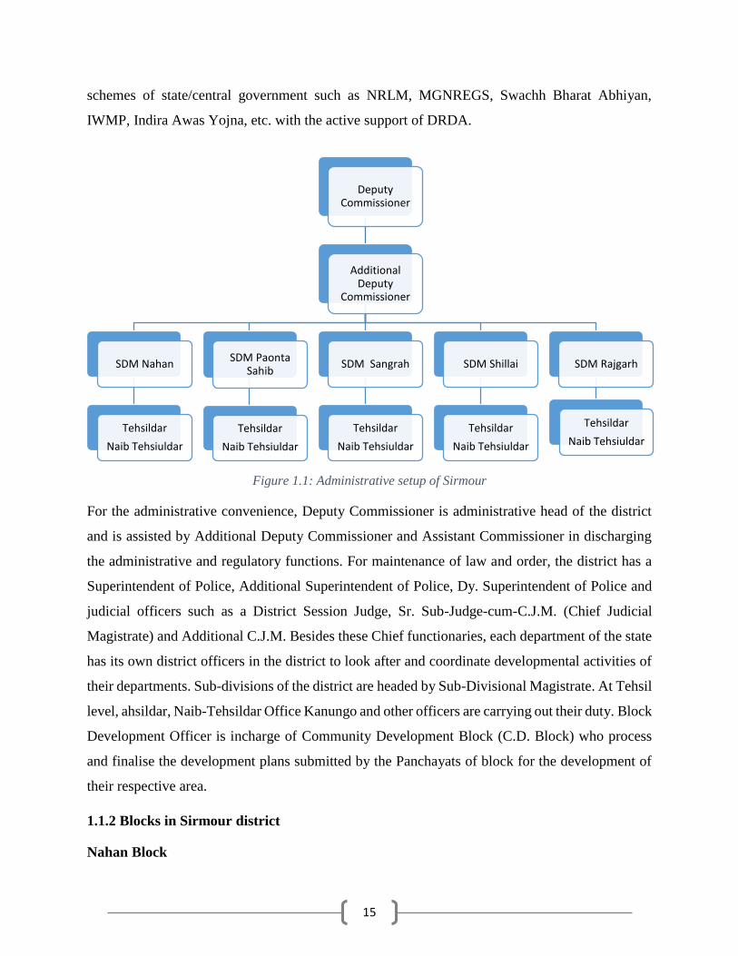
1.1.1 Administrative setup of Sirmour
Sirmour district has six Developmental Blocks, 228 Gram Panchayats and 968 inhabited villages.
Agriculture is the mainstay of the district economy with Wheat and Maize as lead crops. The
district also has two industrial estates located at Paonta Sahib and Kala Amb which are hub for
secondary and territory sector.
No of Sub-Division 5 (Nahan, Paonta Sahib, Rajgarh, Sangrah, Shillai)
No. of Tehsils 6 (Nahan, Paonta Sahib, Pachhad, Shillai, Sangrah, Rajgarh)
No. of Sub-tehsil 7 (Dadahu, Nohra, Kamrau, Ronhat, Narag, Pajhota, Haripurdhar)
No. of Development Blocks 6 (Nahan, Paonta Sahib, Pachhad, Shillai, Sangrah, Rajgarh)
No. of Panchayats 228
No. of Villages 968
There are 228 Gram Panchayats, Six Panchayat Samitis and One Zila Parishad in the district. PRI
in the district and their institutions are involved in implementation of numbers of developmental
15
schemes of state/central government such as NRLM, MGNREGS, Swachh Bharat Abhiyan,
IWMP, Indira Awas Yojna, etc. with the active support of DRDA.
Figure 1.1: Administrative setup of Sirmour
For the administrative convenience, Deputy Commissioner is administrative head of the district
and is assisted by Additional Deputy Commissioner and Assistant Commissioner in discharging
the administrative and regulatory functions. For maintenance of law and order, the district has a
Superintendent of Police, Additional Superintendent of Police, Dy. Superintendent of Police and
judicial officers such as a District Session Judge, Sr. Sub-Judge-cum-C.J.M. (Chief Judicial
Magistrate) and Additional C.J.M. Besides these Chief functionaries, each department of the state
has its own district officers in the district to look after and coordinate developmental activities of
their departments. Sub-divisions of the district are headed by Sub-Divisional Magistrate. At Tehsil
level, ahsildar, Naib-Tehsildar Office Kanungo and other officers are carrying out their duty. Block
Development Officer is incharge of Community Development Block (C.D. Block) who process
and finalise the development plans submitted by the Panchayats of block for the development of
their respective area.
1.1.2 Blocks in Sirmour district
Nahan Block
Deputy Commissioner
Additional Deputy
Commissioner
SDM Nahan
Tehsildar
Naib Tehsiuldar
SDM Paonta Sahib
Tehsildar
Naib Tehsiuldar
SDM Sangrah
Tehsildar
Naib Tehsiuldar
SDM Shillai
Tehsildar
Naib Tehsiuldar
SDM Rajgarh
Tehsildar
Naib Tehsiuldar
16
Nahan is headquarter of Sirmour district. The block is bounded by Paonta Sahib and Sangrah block
on the east side. The southern and western part of the block is bounded with Chandigarh and on
the north it is bounded by Pachhad block.
Nahan is a Block situated in Sirmaur district in Himachal Pradesh. Placed in rural region of
Himachal Pradesh, it is one among the 6 blocks of Sirmaur district. According to the administration
records, the block code of Nahan is 61. As per Census 2011, literacy ratio in Nahan block is 69%.
Among males the literacy rate is 76% while female literacy rate is 62%.
The number of employed person of Nahan block is 35891 while 36762 are non-working. And out
of 35891 working person 13634 peoples are totally reliant on farming.
Paonta Sahib Block
Paonta Sahib is a Block located in Sirmaur district in Himachal Pradesh. Located in rural region
of Himachal Pradesh, it is one among the 6 blocks of Sirmaur district. As per the government
register, the block number of Paonta Sahib is 62. As per Census 2011, literacy ratio in Paonta
Sahib block is 64%. Among males the literacy ratio is 72% while female literacy rate is 56%. The
number of employed individual of Paonta Sahib block is 74760 while 94922 are non-working. And
out of 74760 working people 19074 individuals are completely dependent on farming.
Pachhad Block
Pachhad is a Block placed in Sirmaur district in Himachal Pradesh. Located in rural region of
Himachal Pradesh, it is one among the 6 blocks of Sirmaur district. As per the administration
register, the block code of Pachhad is 60. As per Census 2011, literacy rate in Pachhad block is
76%. Among males the literacy ratio is 81% while female literacy rate is 70% as. The count of
occupied person of Pachhad block is 35352 while 18448 are un-employed. And out of 35352
employed people 20300 persons are completely reliant on farming.
Shillai Block
Shillai is a Block placed in Sirmaur district in Himachal Pradesh. Located in rural region of
Himachal Pradesh, it is one of the 6 blocks of Sirmaur district. As per the government register, the
block code of Shillai is 64. As per Census 2011, literacy rate in Shillai block is 57%. Among males

17
the literacy ratio is 64% while female literacy ratio is 50%. The number of occupied people of
Shillai block is 37545 yet 22684 are non-working. And out of 37545 occupied individual 18214
persons are totally reliant on agriculture.
Sangrah Block
Sangrah is a Block located in Sirmaur district in Himachal Pradesh. Situated in rural region of
Himachal Pradesh, it is one among the 6 blocks of Sirmaur district. As per the administration
records, the block number of Sangrah is 63. As per Census 2011, literacy rate in Sangrah block is
64%. Among males the literacy rate is 70% while female literacy rate is 58. The count of working
people of Sangrah block is 43871 still 26539 are un-employed. And out of 43871 occupied people
23905 individuals are fully dependent on cultivation.
Rajgarh Block
Rajgarh is a Block situated in Sirmaur district in Himachal Pradesh. Located in rural area of
Himachal Pradesh, it is one among the 6 blocks of Sirmaur district. As per the administration
records, the block code of Rajgarh is 59. As per Census 2011, literacy rate in Rajgarh block is
75%. Among males the literacy rate is 79% as whereas female literacy rate is 71%. The count of
employed individual of Rajgarh block is 32844 while 13072 are non-working. And out of 32844
occupied individual 20547 peoples are entirely dependent on cultivation.
1.1.3 Zila Parishad
The Zila Parishad elects its President, Vice President and Chairman of its committees from
amongst the elected members. The terms of these elected members is five years. A senior I.A.S.
Officer is assigned the functions of the Chief Executive Officer of the Zila Parishad who happens
to be the Deputy Commissioner of the district. The Parishad is also assisted by various departments
of the district. At the Block level, the Panchayat Samitis have an elected Chairman and Deputy
Chairman. The Block Development Officer works as Secretary to the Panchayat Samiti. The
Deputy Chief Executive Officer works as a Secretary of the General Body of the Zila Parishad.
Normally, the functions of Secretary are performed by either Additional Deputy Commissioner or
Additional District Magistrate.

18
1.1.4 Urban Local Bodies
The statutory Urban Local Bodies are Cantonments, Municipal Corporations, Municipal Councils
and Nagar Panchayats. The urban local bodies elect a councilor from each of the wards whose
term is five years. From among these elected councilor, Mayor and Deputy Mayor of the Municipal
Councils/ Nagar Panchayats are elected for a term of for five years. Apart from this, the Chairman
of various committees are also elected from amongst the elected councilors with a term of five
years. For day to day administration, the Executive Officer is responsible in a Municipal Council
and Nagar Panchayat. He works under the administrative control of the President of the Municipal
Council and Nagar Panchayat. In the Corporations, an I.A.S. or a senior H.A.S. officer is deputed
by the State Government as Municipal Commissioner who is responsible for day to day
administration and the executive authority lies in him.
1.2 Demography
As per 2011 census, the total population of the district is 5,29,855 out of which population of
female and male are 2,53,566 and 2,76,289 respectively. Sirmour district is the 5th smallest in
population in the state. District is predominantly rural and around 89.2% of the population resides
in rural area. Sirmour ranks 8th in terms of sex-ratio in the state i.e. 918 females per 1,000 males
as against 972 females per 1,000 males of state average. Compared to 2001 census, the decadal
growth in population of Sirmour has been 15.54%, i.e. 1.554% growth per annum. The district has
a literacy rate of 82.8%. The literacy rate of male and female are 89.53% and 75.93% respectively.
Table 1.2: Demography of Sirmour district Block No of
Villages
Covered*
Population
Male Female Children
Nahan 209 46283 42584 12685
Paonta 186 89378 80439 25048
Pachhad 262 24798 23030 5972
Rajgarh 140 22143 20942 5914
Sangrah 121 30546 29220 10644
Shillai 50 27034 23838 9357
Total 968 240182 220053 69620
Source: Census of India *Includes 13 wards in Nahan MC, 11 wards in Paonta MC and 7 wards of Rajgarh NP.

19
Figure 1.2: Demography of Sirmour
The population density of Sirmour district as recorded by 2011 census is 188 people per sq. km.
which is 16% increase in density as compared to 162 people per sq. km as per 2001 census.
Compared to the population density of the State (123 person per sq.km.), the current population
density of Sirmour is on higher side. Sirmour district administers 2,248 square kilometers of areas.
Table 1.3: Distribution of SC, ST and general population in the district Block SC Population ST Population General Population
Nahan 29405 6682 65465
Paonta 40378 4247 150240
Pachhad 20734 96 32970
Rajgarh 21594 144 27261
Sangrah 29990 63 40357
Shillai 18644 30 41555
Total 160745 11262 357848
Figure 1.3: Distribution of SC, ST and General population in the district
46283
89378
24798 2214330546 27034
42584
80439
23030 2094229220
23838
12685
25048
5972 591410644 9357
0
20000
40000
60000
80000
100000
Nahan Paonta Pachhad Rajgarh Sangrah Shillai
Male Female Children
2940540378
20734 2159429990
186446682 4247 96 144 63 30
65465
150240
32970 2726140357 41555
0
20000
40000
60000
80000
100000
120000
140000
160000
Nahan Paonta Pachhad Rajgarh Sangrah ShillaiSC Population ST Population General Population

20
Paonta Sahib is the most populated block of the district whereas Rajgarh has lowest population.
Same trend exists in population density of the blocks. Higher population of Paonta Sahib can be
attributed to industrial establishments and unprecedented urban and industrial development around
Paonta town. Sex ratio in all the development blocks is unfavorable (<1000) to females. It is
highest in Sangrah and lowest in Shillai.
Table 1.4: Distribution of SC, ST and general household in the district Block SC Household ST Household General Household
Nahan 4520 1111 15361
Paonta 6520 653 30000
Pachhad 4096 19 6434
Rajgarh 3877 26 5851
Sangrah 4753 9 6805
Shillai 2496 5 5672
Total 26262 1823 70123
Figure 1.4: Distribution of SC, ST and general households in the district
Total number of household in the district is 98,208 out of which 38% are in Paonta Sahib Block
and 21% are in Nahan block. The total number of SC and ST families in the district are 26,262 and
1823 respectively. In Sangrah block, the number of SC household is to the tune of 41% (of total
household in the block) while the same is 40% in Rajgarh and 39% in Pachhad. In case of ST
families, the percentage of ST household is maximum (5.3% of the total household of the block)
in Nahan block followed by 1.8% in Paonta Sahib and 0.3% in Rajgarh. The number of ST families
in Nahan is 1111 which is 61% of the total ST household in the district. In case of Paonta Sahib,
the number of ST household is 653 which is 36% of the total household in the block.
45206520
4096 3877 475324961111 653 19 26 9 5
15361
30000
6434 5851 6805 5672
0
5000
10000
15000
20000
25000
30000
35000
Nahan Paonta Pachhad Rajgarh Sangrah Shillai
SC Household ST Household General Household

21
1.3 Biomass and Livestock
According to District Agriculture Plan of Sirmour, milk production in the district has increased
from 44707 MT in 1990-91 to 72900 MT in 2006-07. In the total milk production, the share of
cow milk was about two third. The milk production at the state level has also increased from
572605 MT to 872011 MT. However, during 1990-91 the share of cow and buffalo milk in
Himachal Pradesh in the total milk production was around 45 per cent and 53 per cent respectively
which has changed to 53 per cent and 39 per cent during 2003. This huge change in the relative
contribution of cow and buffalo milk could be explained in terms of ongoing process of replacing
indigenous cows with improved ones and the spread of artificial insemination facilities in the rural
areas. As regards wool production in Sirmour, it has increased from 43.229 MT in 1990-91 to
358.3 MT in 2003. At state level, it has increased from 1452.1 MT to 1605.33 MT during the same
period. The production of meat in the district has decreased from 529.24 MT (during 1990-91) to
190.29 MT (during 2003) while at the state level it has decreased from 4049.00 MT to 2934.23
MT during the same period. The production of eggs has also decreased in the district (from 30.616
lakh to 25.78 lakh) while state level figure showed increase (from 531.7 lakh to 771.98 lakh) in
2003 compared to 1990-91.
Table 1.5: Population of small animals (livestock) in Sirmour Tahsil Small Animals
Poultry Pigs Goats Sheep
Dadahu 515 451 11785 443
Kamrau 1010 51 11924 1155
Nahan 1991 210 14770 213
Nohra 42 25 10402 2031
Pachhad 1380 7 17979 1248
Paonta Sahib 3374 227 14446 472
Rajgarh 1650 19 12355 1904
Renuka 131 3 27844 1728
Ronhat 0 153 6430 974
Shillai 783 68 16787 1145
Total (2012) 10876 1214 144722 11313
Total (2001) 67014 1746 138826 17758
Source: Livestock Census, GoHP

22
Table 1.6: Population of large animals (Livestock) in Sirmour Tahsil Large Animals Draft Animal
Indigenous Cow Hybrid Cow In descriptive
Buffalo
Dadahu 10737 2954 1149 49
Kamrau 18185 3918 1913 111
Nahan 21770 8024 6851 151
Nohra 12126 6763 907 316
Pachhad 28824 1407 3976 446
Paonta Sahib 26785 15079 22924 173
Rajgarh 29381 11806 2225 690
Renuka 34338 2725 1385 134
Ronhat 12998 1532 283 119
Shillai 17121 3652 1294 415
Total (2012) 212265 57860 42907 2604
Total (2001) 115113 32447 48612 3876
The district has seen an increase of approximately 14% in the total livestock population which was
recorded as 4,25,392 during Livestock census 2001. Compared to the data recorded during 2001
census, significant changes have occurred in the population of Indigenous and Hybrid Cows. In
case of Indigenous cows, the population has increased by 84.4% while in case of Hybrid cows, the
same has increased by 78.3%. The population of Poultry has shown decrease of 84%, while steep
fall in population of other animals have also been observed. The population of pig has increased
by 30.5%, Sheep by 36.3%, buffaloes by 12% and draft animals by 33%.

23
Figure 1.5: Change in population of animals in Sirmour
Out of 5,03,526 animals (including dogs and rabbits) in Sirmour district, 17% of the animals are
from Paonta Sahib, 14% from Renuka and 12% each from Rajgarh, Pachhad and Nahan Tehsil.
Cow accounts for 53.6% of the total animals (42.2% indigenous & 11.5% hybrid) followed by
Goats 28.7%. Apart from Cow and Goat, buffalo with a population of 42,907 (8.5%) mark their
presence in the district.
1.4 Agro-Ecology, Climate, Hydrology and Topography
Geographically the district can be divided into three parts (i) The Trans- Giri region (ii) Cis-Giri
region (iii) Plains of Kiar-da-dun or Dun Valley.
The Trans- Giri region consists of the wild mountains culminating into the Chur Peak which is
popularly called as Chur Chandni Ki Dhar (the hill of silver bangle). It has an altitude of 3,647
meters above the sea level. From this lofty mountain runs two ranges one in the north-west
direction called Dhar Taproli- Jadol, and other Dhar Nohra which runs in the south-east direction
towards Haripur Fort at an altitude of 2,677 meters above the mean sea level. There ranges separate
the district from the Nehru and Cheta Sub-tehsils and Chaupal tehsil of Shimla district. Two other
ranges run north-west called Dudham Dhar and south-west with many minor spurs from them
towards the east under the name of Dhar Kamrau. The Dhar Shalai runs parallel to the Dhar in the
northern side and both of them form the Valley of Nera River which ultimately joins the Tons
River.
67014
138826
17758
115113
32447
48612
387610876
144722
11313
212265
5786042907
26040
50000
100000
150000
200000
250000
Poultry Goats Sheeps Indigenous Cow Hybrid Cow In descriptiveBuffalo
Draft Animal2001 2012

24
The Trans-Giri region is intersected by three main ranges which run from north-west to south-
west. The first is the Sain Dhar which runs parallel to the Giri River. The second is the Dharthi
Dhar or what is called little range. Between these two Dhars flows river Jalal. The third is quite a
low range which runs from Kala Amb area of south of Nahan tehsil and forms an open valley with
Dharthi Dhar. In the western half of this range flows the Markanda River. Between eastern extreme
of this Dharthi range lies open wide valley known as Kiar-da-dun valley which borders the
Yamuna and Giri rivers in the east, and forms the boundary of the district with Uttar Pradesh. It
also touches western portion of Nahan tehsil. The flat valley is irrigated by Bata River which flows
from east to west originating from Dharthi ranges.
The greater part of the Sirmour district lies on strata of Tertiary age, with beds belonging to the
Carbonaceous System (Krol and Blaini groups) on the north-east. The lower Tertiary rocks are
particularly well developed. The Upper Tertiary, or Siwalik, Series is largely developed in the
neighborhood of Nahan, where the lower beds consist of great mass of sandstones, the Nahan
Groups. These are overlain by sandstones and conglomerates (Middle and Upper Siwalik)
containing a rich mammalian fauna of Pliocene age.
1.4.1 Climate and Rainfall
The district possesses a variety of climate varying according to elevation. Summar months are
exceedingly hot in Dun, and water is scarce. The hilly areas have a temperate climate though the
Dharthi range is hot. The Trans –Giri Tract, Pajota and Sain range areas are comparatively cold
even in summers. Snow falls regularly in winters in Trans-Giri areas whereas in Sain ranges it is
occasional, while in Dharthi ranges it is rarely noticed.
As per the data provided by department, winter season extends from Nov to February; summer
season from March to June followed by the monsoon period extending from July to September
end. Maximum precipitation in the form of rain occurs during July to September. Average annual
rainfall in the district is about 1527 mm, out of which 90% occurs during monsoon season. During
winter period rainfall also occurs in lower hills and valleys parts.
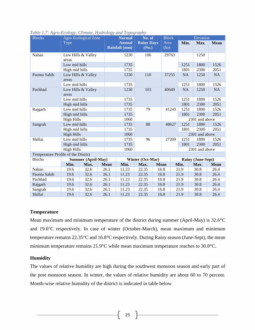
25
Table 1.7: Agro-Ecology, Climate, Hydrology and Topography Blocks Agro Ecological Zone
Type Normal
Annual
Rainfall (mm)
No. of
Rainy Days
(No.)
Block
Area
(ha)
Elevation
Min. Max. Mean
Nahan Low Hills & Valley
areas
1230 106 29763 1250
Low mid hills 1735 1251 1800 1526
High mid hills 1735 1801 2300 2051
Paonta Sahib Low Hills & Valley
areas
1230 110 37255 NA 1250 NA
Low mid hills 1735 1251 1800 1526
Pachhad Low Hills & Valley
areas
1230 103 40649 NA 1250 NA
Low mid hills 1735 1251 1800 1526
High mid hills 1735 1801 2300 2051
Rajgarh Low mid hills 1735 79 41243 1251 1800 1526
High mid hills 1735 1801 2300 2051
High Hills 1060 2301 and above
Sangrah Low mid hills 1735 88 48627 1251 1800 1526
High mid hills 1735 1801 2300 2051
High Hills 1060 2301 and above
Shillai Low mid hills 1735 96 27209 1251 1800 1526
High mid hills 1735 1801 2300 2051
High Hills 1060 2301 and above
Temperature Profile of the District
Blocks Summer (April-May) Winter (Oct-Mar) Rainy (June-Sept)
Min. Max. Mean Min. Max. Mean Min. Max. Mean
Nahan 19.6 32.6 26.1 11.23 22.35 16.8 21.9 30.8 26.4
Paonta Sahib 19.6 32.6 26.1 11.23 22.35 16.8 21.9 30.8 26.4
Pachhad 19.6 32.6 26.1 11.23 22.35 16.8 21.9 30.8 26.4
Rajgarh 19.6 32.6 26.1 11.23 22.35 16.8 21.9 30.8 26.4
Sangrah 19.6 32.6 26.1 11.23 22.35 16.8 21.9 30.8 26.4
Shillai 19.6 32.6 26.1 11.23 22.35 16.8 21.9 30.8 26.4
Temperature
Mean maximum and minimum temperature of the district during summer (April-May) is 32.6°C
and 19.6°C respectively. In case of winter (October-March), mean maximum and minimum
temperature remains 22.35°C and 16.8°C respectively. During Rainy season (June-Sept), the mean
minimum temperature remains 21.9°C while mean maximum temperature reaches to 30.8°C.
Humidity
The values of relative humidity are high during the southwest monsoon season and early part of
the post monsoon season. In winter, the values of relative humidity are about 60 to 70 percent.
Month-wise relative humidity of the district is indicated in table below

26
Table 1.8: Relative humidity in Sirmour during different months
Month Relative Humidity (%) Month Relative Humidity (%)
0830 IST 1730 IST 0830 IST 1730 IST
January 69 65 July 85 79
February 67 62 August 89 84
March 54 51 September 81 77
April 49 42 October 70 64
May 40 32 November 64 59
June 57 49 December 67 62
Annual 66 61 Source: Climatological Summaries of State, Series No. 15, GOI
Driest part of the year is summer when values of relative humidity are less than 50 percent. In
general values of relative humidity are high in the morning than in afternoon throughout the year.
Cloudiness
Skies are generally clear or lightly clouded in the summer and post monsoon season. It remains
heavily clouded to overcast in the southwest monsoon season. In winter, frequent cloud occurs.
Winds
Winds are generally light to moderate throughout the year. Winds are mainly southeasterly or
northwesterly throughout the year, with its frequency more southeasterly in the morning and
northwesterly in the evening except in the southwest monsoon season when winds are predominant
in the southeasterly direction.
Special Weather Phenomena
Thunderstorms occur in winter and summer seasons, its frequency is more in latter part of summer.
Occasionally thunderstorms in winter are accompanied by hail. Fog occurs in winter and early part
of southwest monsoon season.
1.4.2 Flora and Fauna
Mallotus philipinensis, Ardisia solonacea, Murraya koenigii, bauhunia spp, Carrisa spp, Flemengia
spp, Butea monosperma, Ziziphus jujuba, Carrisa spinarum, Woodfordia floribunda, Adhatoda
vasica, Dodonia viscose, Lantana camara, Aegle marmelos, Berberis lycum, Rubus niveus,
Rhododendron arboretum, Myrica spp., Pyrus peshia, Sapium insigne, Festuca agrostis,
Calamagrostis, Dactylis, Bromus, Danthonia, Themeda, Heteropogon, Chrysopogon, Potentilla
agrophylla, Rosa spp, Primula, Anemone, Gentiana, etc., are important plant species found in
canopy, middle and undergrowth of the forests.

27
The district, offering wide range in altitude i.e. from 300 meters to 3647 meters and climatic
situations, is endowed with variety of wild animals and birds. The thick wooded areas provide safe
habitat for the wildlife, though due to increased poaching and indiscriminate lopping of the forests,
there is decrease in the fauna in the district, and some of the species are almost at the verge of
extinction. The Musk Deer, Serow, Panther, Tragopan, and Monal are found in the highest altitude
of Chur Peak in Pajoga, Chursa and Nohra forests. Likewise, lower areas are inhabited with Black
Bear, Barking Deer, Sambhar, Wild Boar, Goral, Koklash, Kalij, Chakor, Patridge, Wolf, Red Fox,
Jackal, Mongoose, Monkey, Langoor and Red Jungle Fowl. Most commonly seen animal is
porcupine, which is found almost in the entire district. This animal mostly feeds on the forest
nurseries, walnut plant, chir and deodar. The Himalayan goat (Ghoral) is found in areas between
900 to 2700 metres elevation of the district. It is a stocky goat like animal which is found in groups
of 4 to 6 grazing on the hill side and in the forests.
Another interesting animal is barking-deer (Kakar) which is found in the chir and ban forests of
Sarahan, Rajgarh and Habban range. In the lower part of Sarahan, Renuka, Jamta and Rajgarh
ranges, pigs are found which generally live on the crop roots, rubber, insects and snakes etc. They
cause a considerable damage to the crops. The pigs are generally found in the herds of 2 to 15 or
even more. Monkeys of Rhesus, Maigna and Langoors are quite common in the entire district. In
the Habban, Rajgarh and Sarahan ranges, beautiful birds like monal are found. The Koklas are
found in the deodar and sometime in the fir forests and prefer moist wooded forests with under
growth. They are commonly found in parts of Habban, Rajgarh, Nohra and Sangrah ranges. The
black partridge are found upto 1800 metres elevation and frequent in the grassy and scrub peaks.
The hill partridge is found beyond chir forests mostly in ban and oak forests and occasionally in
deodar forests. Chakor is an another specie of the pigeon which is found generally between 1500
to 3000 metres elevation in areas of Rajgarh, Sangrah and Shillai ranges.
1.4.3 Fishery
Fishery plays an important role in the rural economy of the district by augmenting food supply,
generating employment and raising nutritional contents of food. There is abundance of fish in
rivers and perennial streams. The important species are Mahasheer, Rohu, Singhara, Baranguli,
Kali Macchi, Kala banas, Bhareli, Mrigal, and Bhunga. Fishery activities in district Sirmour
include riverine fisheries and aquaculture.

28
Department of Fisheries, Himachal Pradesh issues annual licence to the fishermen for fishing in
riverine stretches using cast nets. Main rivers & their tributaries flowing through the district are
Giri, Yamuna, Markanda, Roon Bata, Jalal, Nera & Tonnes. Although pisciculture is a non-
traditional activity, yet depletion of fish in rivers and increasing market demands have forced the
Government as well as farmers to develop the sector. There is a vast scope of fishery development
in the district. Paonta Sahib and to some extent areas of Rajgarh are suitable for fish culture. There
is also a good scope for running water fish culture in Shillai area.
1.5 Soil Profile
Sirmaur district presents an intricate mosaic of high mountain ranges, hills and valleys with altitude
ranging from 300 to 3647 m above MSL. There is general increase in elevation from south to north
and from east to west.
In general Trance Giri terrain exhibits highly rugged mountain terrain. In the areas underlain by
high hill ranges of Himalayas, the valleys are narrow and deep with steep slopes. The terrain is
moderately to highly dissect with steep slopes.
Paonta valley, trending NW-SE, have an area of about 230 sq.km and lies between the main
Himalayan ranges on the north and outer Shivalik hill range in the south. The Yamuna River that
forms the eastern district boundary with the State of Uttaranchal drains major part of Sirmaur
district. Tons, Giri, Bata are its major tributaries. Only a small area in the southeast is drained by
river Markanda of the Ghaggar river basin. Giri River practically bisects the district in to two parts,
namely Trans Giri area and Cis-Giri area. Paonta valley is drained by river Bata a tributary of
Yamuna.

29
Table 1.9: Soil Profile of the district
Block Soil Type
Major Soil Classes Area (ha)
Nah
an
Red Soils 2976
Sandy Soils 5955
Sandy Loams 17856
Others (Clay soil) 2976
Pao
nta
Black Soils 1863
Red Soils 1863
Sandy Soils 9314
Sandy Loams 22352
Others (Clay soil) 1863
Pac
hh
ad
Black Soils 2032
Red Soils 20325
Sandy Soils 4065
Sandy Loams 12195
Others (Clay soil) 2032
Source: Deputy Director Agriculture, Sirmour
Block Soil Type
Major Soil Classes Area (ha)
Raj
gar
h
Black Soils 2062
Red Soils 24750
Sandy Soils 4125
Sandy Loams 4125
Others (Clay soil) 6187
San
gra
h
Black Soils 7494
Red Soils 9992
Sandy Soils 12490
Sandy Loams 17486
Others (Clay soil) 2497 S
hil
lai
Black Soils 2588
Red Soils 7763
Sandy Soils 5175
Sandy Loams 7763
Others (Clay soil) 2588

30
Map 1.2: Soil map of Sirmour
In Nahan and Paonta Sahib Blocks, the maximum area falls under Sandy Loams category which
is 60% of the total area of these blocks. In case of Pachhad and Rajgarh, red soil is available to the
extent of 50% and 60% respectively. Most of the red soil falls under non-agricultural land. In case
of Sangrah and Shillai, Sandy Loam soil is available to the extent of 35% and 30% respectively.
Sandy Loam soil is suitable for most of the crops grown in the district. The major crop for which
this soil class is favorable are wheat, maize, capsicum, tomato, peas, French bean, ginger, garlic,
gram, lentil, sarso and toria.
1.6 Soil Erosion and Runoff Status
More than 80% of the area in the district is sloppy and prone to soil erosion. The problems and
interventions regarding land development have been highlighted in Table 1.6. Water scarcity, soil
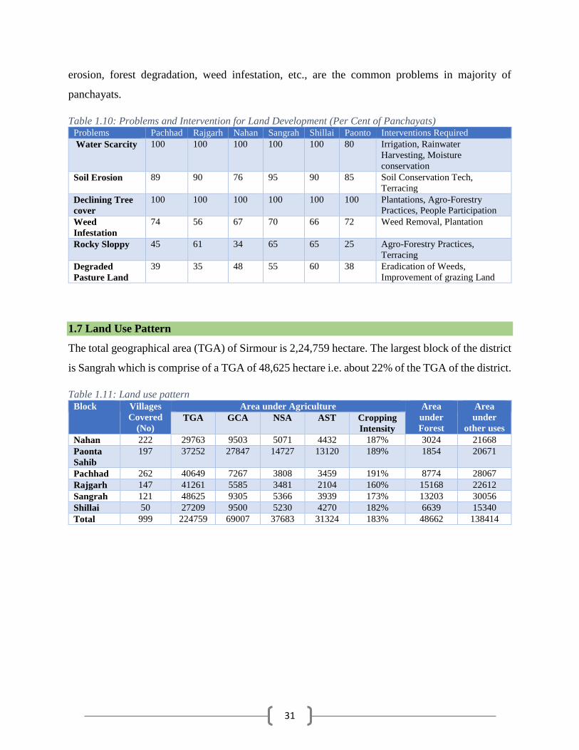
31
erosion, forest degradation, weed infestation, etc., are the common problems in majority of
panchayats.
Table 1.10: Problems and Intervention for Land Development (Per Cent of Panchayats) Problems Pachhad Rajgarh Nahan Sangrah Shillai Paonto Interventions Required
Water Scarcity 100 100 100 100 100 80 Irrigation, Rainwater
Harvesting, Moisture
conservation
Soil Erosion 89 90 76 95 90 85 Soil Conservation Tech,
Terracing
Declining Tree
cover
100 100 100 100 100 100 Plantations, Agro-Forestry
Practices, People Participation
Weed
Infestation
74 56 67 70 66 72 Weed Removal, Plantation
Rocky Sloppy 45 61 34 65 65 25 Agro-Forestry Practices,
Terracing
Degraded
Pasture Land
39 35 48 55 60 38 Eradication of Weeds,
Improvement of grazing Land
1.7 Land Use Pattern
The total geographical area (TGA) of Sirmour is 2,24,759 hectare. The largest block of the district
is Sangrah which is comprise of a TGA of 48,625 hectare i.e. about 22% of the TGA of the district.
Table 1.11: Land use pattern Block Villages
Covered
(No)
Area under Agriculture Area
under
Forest
Area
under
other uses TGA GCA NSA AST Cropping
Intensity
Nahan 222 29763 9503 5071 4432 187% 3024 21668
Paonta
Sahib
197 37252 27847 14727 13120 189% 1854 20671
Pachhad 262 40649 7267 3808 3459 191% 8774 28067
Rajgarh 147 41261 5585 3481 2104 160% 15168 22612
Sangrah 121 48625 9305 5366 3939 173% 13203 30056
Shillai 50 27209 9500 5230 4270 182% 6639 15340
Total 999 224759 69007 37683 31324 183% 48662 138414

32
Figure 1.6: Block wise total geographical area Source: Record maintained by Patwari, Sirmaur
TGA- Total Geographical Area, GCA- Gross Cropped Area, NSA- Net Sown Area, AST- Area Sown more
than once
The Gross Cropped Area of the district is 69,007 hectare out of which 27,847 hectare i.e. 40% of
the area falls in Paonta Sahib Block. Paonta Sahib Block also records for maximum net sown area
of 14,727 hectare i.e. 39% of the net sown area of the district. The cropping intensity in Paonta
Sahib block is 187% and ranks second in the district after Pachhad block where cropping intensity
is 191%. In other blocks of Sirmour, cropping intensity ranges from 173% to 187%. Cropping
intensity of the district is 183%.
13%
17%
18%18%
22%
12%
Nahan Paonta Sahib Pachhad Rajgarh Sangrah Shillai
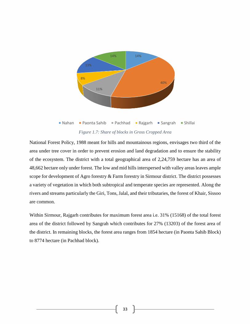
33
Figure 1.7: Share of blocks in Gross Cropped Area
National Forest Policy, 1988 meant for hills and mountainous regions, envisages two third of the
area under tree cover in order to prevent erosion and land degradation and to ensure the stability
of the ecosystem. The district with a total geographical area of 2,24,759 hectare has an area of
48,662 hectare only under forest. The low and mid hills interspersed with valley areas leaves ample
scope for development of Agro forestry & Farm forestry in Sirmour district. The district possesses
a variety of vegetation in which both subtropical and temperate species are represented. Along the
rivers and streams particularly the Giri, Tons, Jalal, and their tributaries, the forest of Khair, Sissoo
are common.
Within Sirmour, Rajgarh contributes for maximum forest area i.e. 31% (15168) of the total forest
area of the district followed by Sangrah which contributes for 27% (13203) of the forest area of
the district. In remaining blocks, the forest area ranges from 1854 hectare (in Paonta Sahib Block)
to 8774 hectare (in Pachhad block).
14%
40%
11%
8%
13%
14%
Nahan Paonta Sahib Pachhad Rajgarh Sangrah Shillai

34
Figure 1.8: Block-wise area under forest in comparison to Total Geographical Area
Map 1.3: LULC change of Sirmour (2016)
10.2%
5.0%
21.6%
36.8%
27.2%
24.4%
0.0%
5.0%
10.0%
15.0%
20.0%
25.0%
30.0%
35.0%
40.0%
Nahan Paonta Sahib Pachhad Rajgarh Sangrah Shillai

35
Map 1.4: LULC change of Sirmour (2000)
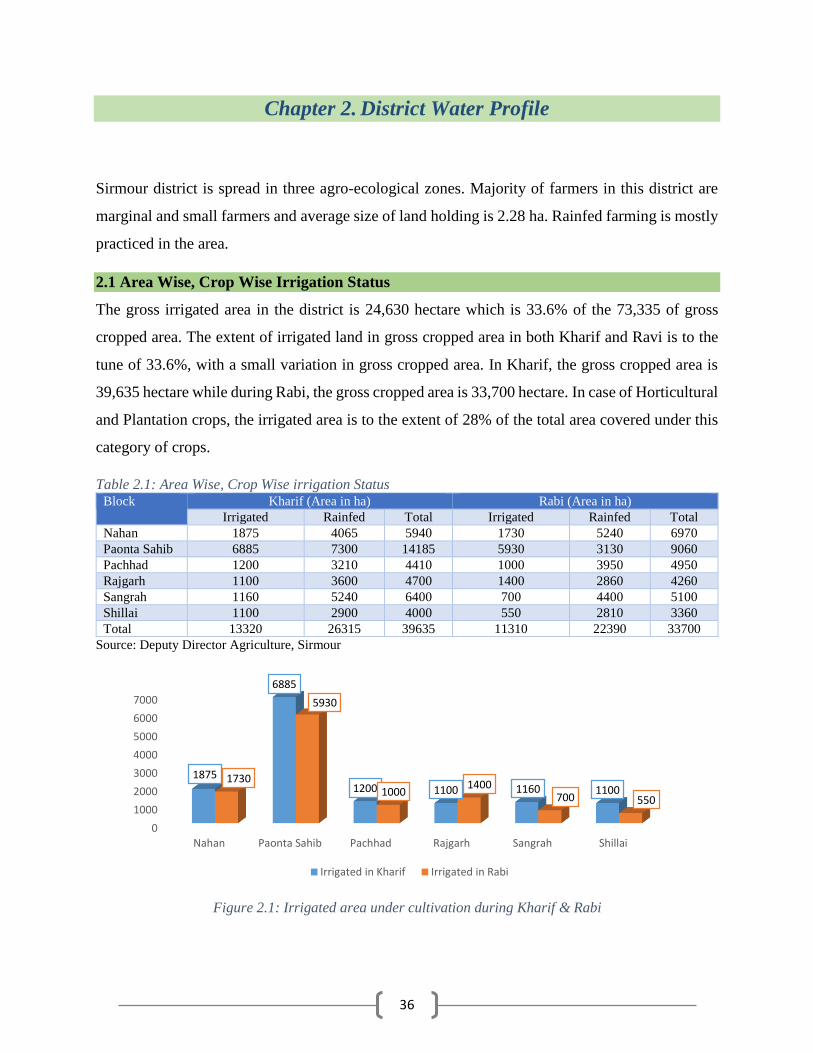
36
Chapter 2. District Water Profile
Sirmour district is spread in three agro-ecological zones. Majority of farmers in this district are
marginal and small farmers and average size of land holding is 2.28 ha. Rainfed farming is mostly
practiced in the area.
2.1 Area Wise, Crop Wise Irrigation Status
The gross irrigated area in the district is 24,630 hectare which is 33.6% of the 73,335 of gross
cropped area. The extent of irrigated land in gross cropped area in both Kharif and Ravi is to the
tune of 33.6%, with a small variation in gross cropped area. In Kharif, the gross cropped area is
39,635 hectare while during Rabi, the gross cropped area is 33,700 hectare. In case of Horticultural
and Plantation crops, the irrigated area is to the extent of 28% of the total area covered under this
category of crops.
Table 2.1: Area Wise, Crop Wise irrigation Status Block Kharif (Area in ha) Rabi (Area in ha)
Irrigated Rainfed Total Irrigated Rainfed Total
Nahan 1875 4065 5940 1730 5240 6970
Paonta Sahib 6885 7300 14185 5930 3130 9060
Pachhad 1200 3210 4410 1000 3950 4950
Rajgarh 1100 3600 4700 1400 2860 4260
Sangrah 1160 5240 6400 700 4400 5100
Shillai 1100 2900 4000 550 2810 3360
Total 13320 26315 39635 11310 22390 33700
Source: Deputy Director Agriculture, Sirmour
0
1000
2000
3000
4000
5000
6000
7000
Nahan Paonta Sahib Pachhad Rajgarh Sangrah Shillai
1875
6885
1200 1100 1160 11001730
5930
10001400
700 550
Irrigated in Kharif Irrigated in Rabi
Figure 2.1: Irrigated area under cultivation during Kharif & Rabi
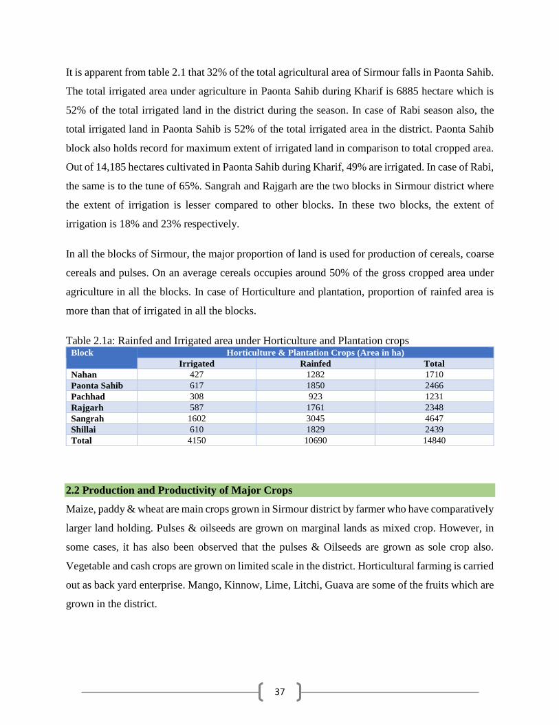
37
It is apparent from table 2.1 that 32% of the total agricultural area of Sirmour falls in Paonta Sahib.
The total irrigated area under agriculture in Paonta Sahib during Kharif is 6885 hectare which is
52% of the total irrigated land in the district during the season. In case of Rabi season also, the
total irrigated land in Paonta Sahib is 52% of the total irrigated area in the district. Paonta Sahib
block also holds record for maximum extent of irrigated land in comparison to total cropped area.
Out of 14,185 hectares cultivated in Paonta Sahib during Kharif, 49% are irrigated. In case of Rabi,
the same is to the tune of 65%. Sangrah and Rajgarh are the two blocks in Sirmour district where
the extent of irrigation is lesser compared to other blocks. In these two blocks, the extent of
irrigation is 18% and 23% respectively.
In all the blocks of Sirmour, the major proportion of land is used for production of cereals, coarse
cereals and pulses. On an average cereals occupies around 50% of the gross cropped area under
agriculture in all the blocks. In case of Horticulture and plantation, proportion of rainfed area is
more than that of irrigated in all the blocks.
Table 2.1a: Rainfed and Irrigated area under Horticulture and Plantation crops Block Horticulture & Plantation Crops (Area in ha)
Irrigated Rainfed Total
Nahan 427 1282 1710
Paonta Sahib 617 1850 2466
Pachhad 308 923 1231
Rajgarh 587 1761 2348
Sangrah 1602 3045 4647
Shillai 610 1829 2439
Total 4150 10690 14840
2.2 Production and Productivity of Major Crops
Maize, paddy & wheat are main crops grown in Sirmour district by farmer who have comparatively
larger land holding. Pulses & oilseeds are grown on marginal lands as mixed crop. However, in
some cases, it has also been observed that the pulses & Oilseeds are grown as sole crop also.
Vegetable and cash crops are grown on limited scale in the district. Horticultural farming is carried
out as back yard enterprise. Mango, Kinnow, Lime, Litchi, Guava are some of the fruits which are
grown in the district.
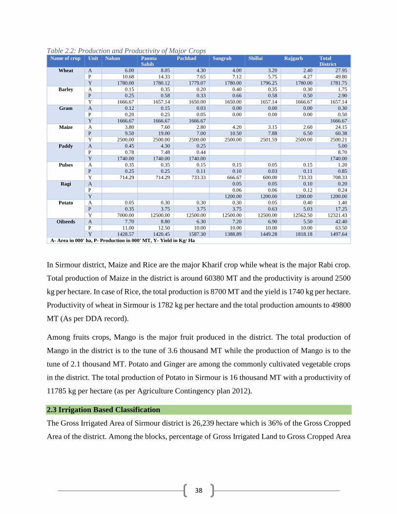
38
Table 2.2: Production and Productivity of Major Crops Name of crop Unit Nahan Paonta
Sahib Pachhad Sangrah Shillai Rajgarh Total
District
Wheat A 6.00 8.05 4.30 4.00 3.20 2.40 27.95
P 10.68 14.33 7.65 7.12 5.75 4.27 49.80
Y 1780.00 1780.12 1779.07 1780.00 1796.25 1780.00 1781.75
Barley A 0.15 0.35 0.20 0.40 0.35 0.30 1.75
P 0.25 0.58 0.33 0.66 0.58 0.50 2.90
Y 1666.67 1657.14 1650.00 1650.00 1657.14 1666.67 1657.14
Gram A 0.12 0.15 0.03 0.00 0.00 0.00 0.30
P 0.20 0.25 0.05 0.00 0.00 0.00 0.50
Y 1666.67 1666.67 1666.67 1666.67
Maize A 3.80 7.60 2.80 4.20 3.15 2.60 24.15
P 9.50 19.00 7.00 10.50 7.88 6.50 60.38
Y 2500.00 2500.00 2500.00 2500.00 2501.59 2500.00 2500.21
Paddy A 0.45 4.30 0.25 5.00
P 0.78 7.48 0.44 8.70
Y 1740.00 1740.00 1740.00 1740.00
Pulses A 0.35 0.35 0.15 0.15 0.05 0.15 1.20
P 0.25 0.25 0.11 0.10 0.03 0.11 0.85
Y 714.29 714.29 733.33 666.67 600.00 733.33 708.33
Ragi A 0.05 0.05 0.10 0.20
P 0.06 0.06 0.12 0.24
Y 1200.00 1200.00 1200.00 1200.00
Potato A 0.05 0.30 0.30 0.30 0.05 0.40 1.40
P 0.35 3.75 3.75 3.75 0.63 5.03 17.25
Y 7000.00 12500.00 12500.00 12500.00 12500.00 12562.50 12321.43
Oilseeds A 7.70 8.80 6.30 7.20 6.90 5.50 42.40
P 11.00 12.50 10.00 10.00 10.00 10.00 63.50
Y 1428.57 1420.45 1587.30 1388.89 1449.28 1818.18 1497.64
A- Area in 000' ha, P- Production in 000' MT, Y- Yield in Kg/ Ha
In Sirmour district, Maize and Rice are the major Kharif crop while wheat is the major Rabi crop.
Total production of Maize in the district is around 60380 MT and the productivity is around 2500
kg per hectare. In case of Rice, the total production is 8700 MT and the yield is 1740 kg per hectare.
Productivity of wheat in Sirmour is 1782 kg per hectare and the total production amounts to 49800
MT (As per DDA record).
Among fruits crops, Mango is the major fruit produced in the district. The total production of
Mango in the district is to the tune of 3.6 thousand MT while the production of Mango is to the
tune of 2.1 thousand MT. Potato and Ginger are among the commonly cultivated vegetable crops
in the district. The total production of Potato in Sirmour is 16 thousand MT with a productivity of
11785 kg per hectare (as per Agriculture Contingency plan 2012).
2.3 Irrigation Based Classification
The Gross Irrigated Area of Sirmour district is 26,239 hectare which is 36% of the Gross Cropped
Area of the district. Among the blocks, percentage of Gross Irrigated Land to Gross Cropped Area
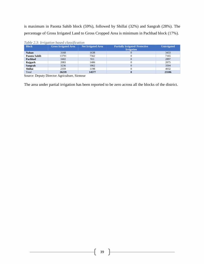
39
is maximum in Paonta Sahib block (59%), followed by Shillai (32%) and Sangrah (28%). The
percentage of Gross Irrigated Land to Gross Cropped Area is minimum in Pachhad block (17%).
Table 2.3: Irrigation based classification Block Gross Irrigated Area Net Irrigated Area Partially Irrigated/ Protective
Irrigation
Unirrigated
Nahan 3168 1638 0 3433
Paonta Sahib 13791 7562 0 7165
Pachhad 1602 911 0 2897
Rajgarh 2083 1406 0 2075
Sangrah 3236 1862 0 3504
Shillai 2359 1198 0 4032
Total 26239 14577 0 23106
Source: Deputy Director Agriculture, Sirmour
The area under partial irrigation has been reported to be zero across all the blocks of the district.

40
Chapter 3. Water Availability in Sirmour
Major parts of Sirmour district are hilly & mountainous with highly dissected and undulating
terrain. These areas are underlain by semi-consolidated and consolidated hard rocks of Tertiary
and Pre-Tertiary period. Ground water potential in such areas is very low due to its hydro-
geomorphic set up. Springs are the main ground water sources that provide water supply for
domestic and irrigation in major rural and urban areas.
3.1 Status of Water Availability
3.1.1 River and Khads (Tributaries)
The district is drained by a number of rivers, rivulets and streams, of these; river Giri is the biggest
river in the district which is tributary of river Yamuna.
The Giri- River Giri is the biggest river in the district which originates at Kupar Tibba in Jubbal
tehsil of Shimla district. It enters the Sirmour district at village Mariog from the north side of the
district. It flows for a distance of 84 kms in the district before merging with the Yamuna River at
Rampur Ghat. It drains out the maximum quantity of water of this district with the help of its
tributaries. It runs for some distance by forming boundary of the district with Solan district and
then takes a turn towards east dividing the district into two almost equal parts. The Rampur Giri
canal has been constructed which irrigates the land of Paonta valley. Important tributaries of Giri
are Jalal, Nait, Palar, Bajhethy, Terui, Kohal and Joggar.
The Tons- Another important river which forms the eastern border of the district is the river Tons.
The source of this river lies in the Jamnotri Mountain and after coursing through the territories of
Jaunsar area of Dehradun district, it enters the district near village Kot of Shalai tehsil separating
it from Jaunsar area. After flowing for about 80 kms, it joins the river Yamuna near Khodar Majri.
It is one of the most considerable of the mountain torrents. The principal tributaries of the Tons
are Bhangal, Neweli or Nera and Sainj. The current of this river is very swift and the course of the
river is full of stones.
The Yamuna- The river originates from the Yamnotri Glacier in the Himalayas lying in Uttarkashi
district of Uttrakhand it flows along the south eastern boundary of the district at village Khodar
Majri and after travelling a distance of about 22 kms it leaves the district at village Kaunch before
entering again into the state of Uttrakhand. Since this river flows at a lower level than the plateau
41
of the Kiar-da-dun, its water cannot be used for irrigating the area. The notable tributaries of the
river in the district are the Tons meeting it at Khodar Majri, the Giri joining it near Rampur Ghat
and the Bata mingling its water with it at Bata Sirmour.
The Jalal- This small, shallow and narrow river rises near village Bani below Nehi in tehsil
Pachhad and forms a dividing line between the Sain and the Dharthi ranges. It falls into the Giri
River at Dadahu losing its entity.
The Markanda- It rises at Baraban reserve forest in the hill of Katasan and passes below the
temple of Katasan Devi. After flowing for a distance of about 24 kms from south-east to south-
west in the district, it passes in to the Ambala district at Kala-Amb when it becomes more wide
and plain. It is joined by a streamlet named Salani at village Dewani. Area of Kala-amb,
Shambhuwala, Rukhri, Bir Bikrambag and the Khadar-Ka-Bag are irrigated by it and a few water
mills also run with the waters of this river. This river is also considered sacred.
The Bata- River Bata rises from Siori spring in the Dharthi range located in village Bagna of
Nahan tehsil. After taking an easterly direction, reverse to the course of Markanda and dividing
Kiar-da-dun valley into two parts, it joins the river Yamuna at Bata Sirmour losing its separate
entity. Dun area of the district is irrigated by its water. It is a perennial stream usually formidable.
The Ghaggar- This River rises near Lowasa in the district and flows in the westerly direction.
The whole of southern slope of the Dharthi Dhar upto Lowasa range drains out in this river. It
flows for about 13 km in Pachhad tehsil of the district before it enters the state of Haryana near
Prit Nagar. Before sufficient water is collected in this river, it crosses the limits of the district. It
has only two main tributaries viz., the Lah which runs throughout Ghinni tract and Deh which
drains out Ghar portion of the Ponwala Jagir. Near its source, and for a number of Kilometers
further on, it has a well-defined boulder-stream bed which is never dry.
Surface water is being tapped by Irrigation and Public Health Department by constructing lift
irrigation schemes (LIS) and flow irrigation schemes (FIS) i.e. kuhls. In Paonta Sahib block, canal
irrigation also exists. There are 5 canals namely Left Bank Canal, Rampur Giri Canal, Giri
Puruwala Canal, Right Bank Canal and Bata Majra Canal. LIS exists in all the blocks as also the
FIS.

42
3.1.2 Lakes and Tanks
The Renuka Lake which is regarded as the embodiment of Renuka Ji, the wife of sage Jamadagni
and mother of Parshurama, is a sacred place for the Hindus. This placid stretch of water is the
largest lake in Himachal Pradesh.
Table 3.1: Status of water availability Source Kharif crop
area (ha) Volume of
water (cum) Rabi
crop area
(ha)
Volume of
water(cum) Summer
crop
(ha)
Volume of
water
(cum)
Total Volume
of water
(cum)
1. Nahan Block
Surface Irrigation
Lift irrigation Diversion 847.12 67862 797.67 181917 175.28 3304 253083
F.I.S 23.5 1883 19.7 4493 4.65 88 6464
Ground Water
Deep Tubewell 20.00 1602 20.00 4561 4.24 80.00 6243
2. Pachhad Block
Surface Irrigation
Minor Irrigation Tank (FIS) 65.62 0.066 65.62 0.07 0.00 131.24 0.1329
F.I.S 65.62 5257 65.62 14965 13.90 262 20484
Ground Water Not available
3. Paonta Block
Surface Irrigation
Canal, Major & Medium
Irrigation )
3801.00 304498 3745.60 854222 1599.12 30143.00 1188863.00
Lift Irrigation Diversion 906.2 72596 889.41 202839 380.50 7172.00 282607
F.I.S 1351.01 108229 1289.48 294079 554.50 10452.00 412760
Ground Water
Deep Tubewell 425.25 34067 324.25 73948 150.00 2828.00 110843
4. Shillai Block
Surface Irrigation
Minor Irrigation Tank (FIS) 0.12 0.11 0.00 0.00 0.23
FIS 125.61 10063 112.31 25613 52.34 987.00 36663
Ground Water Not available
5. Sangrah Block
Surface Irrigation
Minor Irrigation (FIS) 135.84 10882 135.84 30980.00 339.60 6401.00 48263
Lift Irrigation/ Diversion 87.53 7012 87.53 19962 43.76 825.00 27799
Ground Water Not available
6. Rajgarh Block
Surface Irrigation
Minor Irrigation (FIS) 160.45 12854 160.45 36592 80.22 1512.00 50958
Lift Irrigation/ Diversion 122.66 9826 122.66 27974 61.33 1156.00 38956
Ground Water Not available
As per the data provided by IPH Sirmour, Ground water is available in two blocks i.e. Nahan and
Paonta Sahib only. In these two blocks, availability of ground water is assessed by CGWB. The
ground water is made available in these two blocks through deep tubewell. The availability of
ground water in the district has been discussed in para 3.2.
Surface water is available in all the blocks of Sirmour district. The total availability of Surface
water in the district can irrigate a total of 18325 hectares. Out of the total available potential with
the district, 79% is available in Paonta Sahib block. Nahan has 10% of the total surface water

43
available with the district and the rest 11% is shared by remaining 4 blocks. Flow Irrigation System
and Lift Irrigation System is used in the district for supply of surface water.
3.2 Status of Ground Water Availability
3.2.1 Hydrogeology
Geologically, the rock formations occupying the district range in age from pre-Cambrian to
Quaternary period. The generalized geological succession in the district is given below
Era Period Formation Lithology
Quaternary Recent to
Pleistocene
Alluvium/ valley
fills/ Older alluvium
Sand with pebble and clay & multiple cyclic sequence of
medium to coarse grained sand with pebble of sandstone and
lenses of clay
Pliocene- Siwalik Sandstone, shale, conglomerate,
Tertiary M-Miocene Group mudstone, clay , gravel and boulder beds
L-Miocene Kasauli/ Dags Grey, purple sandstone, Shale, nodular
Oligo- Eocen Hai/ Subathu clay, Shale, Limestone etc.
Pemo Karol/ Infra Limestone, Shale, red shale
Pre- Carboniferous Karol, Blainis Carbonaceous shale, slate, greywacke,
Tertiary Boulder beds Dolomitic limestone.
Group Devonian Jaunsar series Slates schist phyllite,
Pre-
Cambrian
Chail series Slates called Shimla slates
Achaean Jutogh series Quartzites, schist and limestones
Paonta valley is a narrow tectonic valley or dun and has fluvial and fluvioglacial sediments Hydro-
geologically, the unconsolidated and semi-consolidated/ consolidated rock formations form
aquifers in the district. Intergarnular pore spaces in the sedimentary formations and secondary
fissured porosity in hard rocks, topographical set up coupled with precipitation in the form of rain
and snow, mainly govern occurrence and movement of ground water. Porous alluvial formation
occurring in the valley area forms the most prolific aquifer system where as the sedimentary semi-
consolidated formations and hard rocks form aquifer of low yield prospect. Major parts of the
district are hilly & mountainous with highly dissected and undulating terrain. These areas are
underlain by semi-consolidated and consolidated hard rocks of Tertiary and pre-Tertiary period.
Ground water potential in such areas is very low due to its hydro-geomorphic set up.
.

44
Map 3.1: Hydrogeology map of Sirmour
Springs are the main ground water structures that provide water supply for domestic and irrigation
in major rural and urban areas. Springs are the major ground water sources of water supply in the
district. These springs are mainly gravity, contact or fracture type and springs located along major
thrust/ faults or structurally weak planes are high yielding. The springs, locally called Chasma,
have discharges varying from seepages to 15 litres per second. Bowries, a type of dug well, are
another structure constructed in the hill slopes to tap the seepages. Such Bowries are common and

45
observed in all the southern part of the district. During the last decade, state government have
drilled shallow bore wells fitted with hand-pumps to provide domestic water. These hand pumps
have average depth of 50-60 m and have low discharges of around 1 lps.
In valley area of Paonta Sahib, the ground water occurs in porous unconsolidated alluvial
formation (valley fills) comprising, sand, silt, gravel, cobbles/pebbles etc. Ground water occurs
both under phreatic & confined conditions. Wells and tube wells are the main ground water
abstraction structures. Ground water is being developed in the area by medium to deep tube wells,
dug wells, dug cum bored wells. Depth of water level shows wide variation from near surface to
more than 35 m bgl (below Ground Level). Yield of shallow aquifer is moderate with well
discharges up to 10 lps.
CGWB has drilled/constructed 11 exploratory wells in the valley area in the depth range of 90.00
to 163.00 m bgl. Static water level of the tube wells ranges from 2 m to 43.00 m bgl and discharge
ranges from 200 to 3220 lpm.
In Paonta valley area, there are 12-hydrograph network stations where depth of water level is
monitored four times a year and ground water quality once during pre-monsoon period. Depth of
water table shows wide variation. During pre-monsoon period (May 2012) it was between 3.76 &
43.98 m bgl, while during the post-monsoon period (Nov 2012) depth of water level was from 2.98
to 37.35 m bgl. Deeper water levels are observed mainly in northwestern part and along the
foothills. In major parts of the valley the depth of water level are less than 17.00 m bgl. (Fig 3.2 &
3.3).
Long-term water level fluctuation analysis for the period of May 2012 with respect to decadal
average of 2002 to 2011 indicates that fall in water level up to 2 m is observed in most part of the
valley. However, in isolated pockets in western and eastern part of Paonta valley rise of water level
up to 5 m is also observed (Fig 3.3).
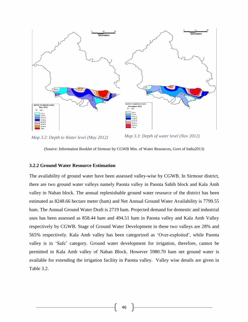
46
(Source: Information Booklet of Sirmour by CGWB Min. of Water Resources, Govt of India2013)
3.2.2 Ground Water Resource Estimation
The availability of ground water have been assessed valley-wise by CGWB. In Sirmour district,
there are two ground water valleys namely Paonta valley in Paonta Sahib block and Kala Amb
valley in Nahan block. The annual replenishable ground water resource of the district has been
estimated as 8248.66 hectare meter (ham) and Net Annual Ground Water Availability is 7799.55
ham. The Annual Ground Water Draft is 2719 ham. Projected demand for domestic and industrial
uses has been assessed as 858.44 ham and 494.51 ham in Paonta valley and Kala Amb Valley
respectively by CGWB. Stage of Ground Water Development in these two valleys are 28% and
565% respectively. Kala Amb valley has been categorized as ‘Over-exploited’, while Paonta
valley is in ‘Safe’ category. Ground water development for irrigation, therefore, cannot be
permitted in Kala Amb valley of Nahan Block. However 5980.70 ham net ground water is
available for extending the irrigation facility in Paonta valley. Valley wise details are given in
Table 3.2.
Map 3.2: Depth to Water level (May 2012)
Map 3.3: Depth of water level (Nov 2012)

47
Table 3.2: Status of ground water availability
Sl. Ground Water Resources (Paonta Valley) March 2011
i. Assessment Unit (Paonta Valley) 15627.00 hectare
ii. Existing gross ground water draft for all uses 2174.46 ham
iii. Total Annual Ground Water Recharge 8108.39 ham
iv. Natural Discharge during Non-Monsoon season 810.84 ham
v. Allocation for domestic and industrial requirement supply
up to next 25 years
858.44 ham
vi. Net ground water availability for future irrigation
development
5980.70 ham
vii. Stage of ground water development 26.66%
viii. Category of the assessment unit Safe
Ground Water Resources (Kala Amb Valley) March 2011
i. Assessment Unit (Kala Amb Valley) 250.00 hectare
ii. Existing gross ground water draft for all uses 545.32 ham
iii. Total Annual Ground Water Recharge 101.66 ham
iv. Natural Discharge during Non-Monsoon season 10.16 ham
v. Allocation for domestic and industrial requirement supply
up to next 25 years
494.51 ham
vi. Net ground water availability for future irrigation
development
0.00 ham
vii. Stage of ground water development 564.63%
viii. Category of the assessment unit Over Exploited
Map 3.5 depicts the ground water availability and user map of Sirmour district. The areas in blue
colour indicate soft rock aquifer areas which are suitable for dug well and tube wells. However, as
indicated above Kala Amb valley is overexploited and further ground water development is not
recommended.
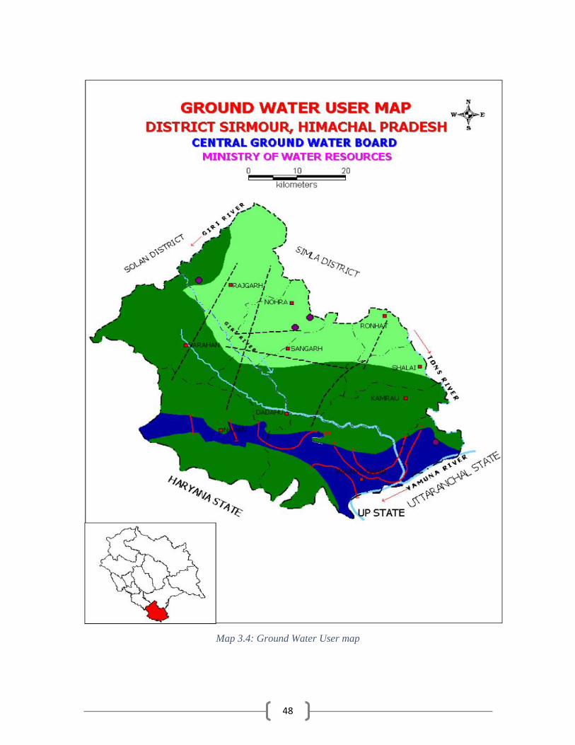
48
Map 3.4: Ground Water User map

49
3.3 Status of Command Area
There are five canals in Paonta Sahib Block. The canal and the command area (villages) covered
are as follows-
Canal Villages in Command Area
Lef
t B
an
k
Ca
na
l
Tokion, Kheri, Chandpur, Kotri, Bias, Gulabgarh, Toka Nagla, Ganguwala, Jamniwala, Bain Kuan,
Dharamkot, Patti Khara, Gondpur, Taruwala, Bherewala, Bhungrani, Shubhkhera, Ghunghlo,
Amarkot, Jawalapur, Kanshipur, Nihalgarh, Patti Natha Singh
Ra
mp
ur
Gir
i
Ca
na
l Ambwala, Rampur ghat, Kunja, Devi Nagar, Shubhkhera, Patti Heerpur Taruwala, Taruwala,
Badripur, Paonta Sahib, Shamsherpur, Bhuppur, Kedarpur, Dharamkot, Bhatanwali
50
Gir
i
Pu
ruw
ala
Ca
na
l Dobri, Puruwala, Khoronwala, Gorkhuwala, Manpur Deora, Shyampur
Rig
ht
Ba
nk
Ca
na
l
Tokion, Behrampur, Salamatpur, Sainwala, Mubarikpur, Majra, Fatehpur, Kiratpur, Bhagwanpur,
Malion, Jagatpur, Misserwala, Johron, Pipliwala, Amargarh, Puruwala Kanshipur, Puruwala
Santokhgarh, Surajpur, Patlion, Ghutanpur, Batamandi, Satiwala, Behral.
Ba
ta
Ma
jra
Ca
na
l Majra, Misserwala, Pipliwala, Amargarh, Puruwala Santokhgarh
Table 3.3: Status of command area Name of village Information of canal Command Information on the other services
Command
Total Area
TA
(1)
DA
(2)
UDA
(3)
TA
(4)
DA
(5)
UDA
(6)
DC
(2+5)
UDC
(3+6)
Left Bank Canal 1970 1423 547 0 0 0 1423 547
Rampur Giri Canal 810 300 510 0 0 0 300 510
Giri Puruwala Canal 531 300 231 0 0 0 300 231
Right Bank Canal 2920 1450 470 0 0 0 1450 470
Bata Majra Canal 130 0 130 0 0 0 0 130
TA- Total Area, DA- Developed Area, UDA- Undeveloped Area, DC- Developed Command, UDC- Undeveloped Command
The percentage developed command area of the total area is better in case of Left Bank Canal
(72%), Giripuruwala Canal (56%) and Right Bank Canal (50%). As reported by the IPH Sirmour,
100% of the command area of Bata Majra Canal is undeveloped.
3.4 Existing Type of Irrigation
In total, there are 205 sources of irrigation in Sirmour district. Paonta Sahib has maximum number
of sources of irrigation, i.e. 96 out of 205 sources of irrigation in the district. After Paonta Sahib,
Nahan and Sangrah are equipped with comparatively more number of sources of irrigation. In
Nahan, there are 34 irrigation sources while in Sangrah 28 irrigation sources are available. Shillai
and Pachhad are the block with least number of irrigation sources. In Shillai, only 11 irrigation
sources are available while in Pachhad only 13 irrigation sources are available.
In Sirmour district, there are 5 canals and all falls in Paonta valley only. These 5 canals are
Government owned canal. There are no community owned/ Private canal, community ponds or
individual private ponds in Sirmour district.

51
Table 3.4: Existing type of irrigation (Surface water)
Block Source of
irrigation
(Nos.)
Surface irrigation (1)
Canal based Tanks/Ponds/ Reservoir
Govt. canal Community/
Pvt. Canal
Community
Ponds
Individual/ Pvt.
Pond
Govt. Reservoir / Dams/
Spring Source/ Khad
1 2 3 4 5 6
Paonta Sahib 96 5 --- --- --- 1
Shillai 11 --- --- --- --- 11
Sangrah 28 --- --- --- --- 28
Rajgarh 23 --- --- --- --- 23
Nahan 34 --- --- --- --- 2
Pachhad 13 --- --- --- --- 13
Total 205 5 78
Block Ground Water (2)
Tube well Open well Bore well Other sources including
Traditional WHS (3)
Treated effluent
discharged from STP Govt.
Pvt. Community/ Govt.
Pvt. Govt. Pvt.
7 8 9 10 11 12 13 14
Paonta Sahib 31 --- --- --- --- --- --- ---
Shillai --- --- --- --- --- --- --- ---
Sangrah --- --- --- --- --- --- --- ---
Rajgarh --- --- --- --- --- --- --- ---
Nahan 2 --- --- --- --- --- --- ---
Pachhad --- --- --- --- --- --- --- ---
Total 33
Block Water extraction devices/ Lift Total
Electricity Pump (4) Diesel Pump (5) Others (6) Irrigation sources (1+2+3)
Water extracting units (4+5+6)
15 16 17
Paonta Sahib 48 --- --- 37 48
Shillai 0 --- 11 11 11
Sangrah 5 --- 23 28 28
Rajgarh 8 --- 15 23 23
Nahan 32 --- --- 4 32
Pachhad 1 --- --- 13 1
Total 94 49 116 143
Out of 78 available government reservoirs, only 1 is in Paonta Sahib. Maximum number of
government reservoirs are in Sangrah Block (28) and Rajgarh Block (23). In Nahan Block, only 2
Government reservoirs are available.
There are 33 Tube Wells in Sirmour district. All the tube wells in the district are government
owned. Out of total 33 tube wells, 31 are in Paonta Sahib and remaining 2 are in Nahan Block.
There are 143 water extraction devices/ lifts in Sirmour district of which 94 are electricity pumps
and 49 are from other category. Out of 94 electricity pumps, 48 are available in Paonta Sahib only.
Nahan block has 32 electricity pumps. In Shillai block, there are no electricity pump while in
Pachhad, there is only one electricity pump. Among the sources classified under ‘others’ category,
23 are in Sangrah, 15 in Rajgarh and 11 in Shillai block.

52
Chapter 4. Water Requirement /Demand
The earlier Chapters deal with the general profile, water profile and water availability of Sirmour
district. The present chapter deals with the current and projected (2020) demand of water for
various sectors. The demand for water has been assessed on the basis of data obtained from
different departments.
4.1 Domestic Water Demand
Data of Census 2011 and 2001 has been considered to arrive at the growth rate of population of
the district. As per Census 2011, the district has shown an annual growth rate of 1.554%. Table
4.1 below indicates the block-wise population of the district. Current and projected population has
been estimated assuming the same growth rate of 1.554% per annum.
Figure 4.1: Current and Projected Population in various blocks of Sirmour
It has been assumed that per capita daily water requirement of people residing in urban areas of
the district is 150 Litres and for population in rural areas, the daily per capita daily water
requirement is 70 Litres. Using the same norms domestic water supply demand has been worked
out and given in table 4.1 below.
102
195
54 49
7060
3
29 25
116
223
62 56
8169
4
33 29
0
50
100
150
200
250
Nahan PaontaSahib
Pachhad Rajgarh Sangrah Shillai Rajgarh (U) Nahan (U) Paonta (U)
Population in 2011 Projected Population in 2020

53
Table 4.1: Domestic Water Demand (MCM) Blocks Population in 2011 Existing Population Present Water
Requirement
Projected
Population in 2020
Annual Water
Requirement in 2020
Nahan 101552 107,864 2.756 116246 2.970
Paonta Sahib 194865 206,978 5.288 223060 5.699
Pachhad 53800 57,144 1.460 61584 1.573
Rajgarh 48999 52,045 1.330 56089 1.433
Sangrah 70410 74,787 1.911 80598 2.059
Shillai 60229 63,973 1.635 68944 1.762
Rajgarh (U) 3083 3,275 0.179 3529 0.193
Nahan (U) 28899 30,695 1.681 33080 1.811
Paonta (U) 25183 26,748 1.464 28827 1.578
Total 587020 623,509 17.704 671956 19.079
Figure 4.2: Present and projected water requirement in MCM
It can be inferred from the table that considering the growth rate of population of the district, the
quantity of water required in 2020 for domestic consumption shall be approximately 19.079 MCM
which is 1.375 MCM more than the present water requirement.
4.2 Crop Water Requirement
Maize-wheat, Paddy-Wheat, Maize-pulses-wheat, Maize-toria-wheat, Pulses (Mash) based,
oilseed (toria, sarson) based, vegetables (tomato, potato and garden peas), spices (ginger, garlic,
chilly, coriander), etc., are the important cropping pattern being followed in the district under
rainfed and irrigated system. In most of the cultivated land, double cropping season was followed.
Rabi season crop was mainly dependent upon timely rainfall in November and December months.
Analysis of Block-wise cropping pattern (Annexure-2.2) reveals that wheat, maize, paddy, and
barley are the cereals grown by farmers. Paddy, Maize and wheat collectively accounted for about
78% of area under agricultural crops, followed by vegetables which occupies 16% of the total area
0
1
2
3
4
5
6
Nahan PaontaSahib
Pachhad Rajgarh Sangrah Shillai Rajgarh(U)
Nahan (U) Paonta (U)
2.756
5.288
1.461.33
1.911 1.635
0.179
1.6811.464
2.97
5.699
1.573
1.433
2.0591.762
0.193
1.8111.578
Wat
er r
equ
irem
ent
in M
CM
Present Water Requirement (2015) Annual Water Requirement in 2020

54
during 2015-16. Paddy is mainly grown in Paonta Sahib while barley is cultivated more in hilly
areas. Among vegetables, tomato, potato and gree peas are important. Area under vegetables is
more in hilly blocks as they have advantage of producing off-season vegetables, which fetch better
returns. Mango, Apple, peach and kinnow are the main fruit crops of this district. Rajgarh has
taken lead in the fruit production and is known for its peaches and apples. Kinnows grown in
Paonta area have special place in the neighboring markets. This district is known as spice bowl of
the state. Recently cultivation of Ginger and garlic has also started in the district.
Area under different crops has been discussed in Chapter 2 (Table 2.2). Taking into account, the
water requirement (Table 4.2b), requirement of water for different crops have been worked out.
Existing water potential available (being utilized) has been assumed as the water used in irrigated
land.
Table 4.2: Crop Water Requirement in Million Cubic Meter Block Area sown
(Ha)
Irrigated
area (ha)
Crop Water
Demand
Water Potential
Required
Existing Water
Potential
Water Potential to
be created
Nahan 14620 4033 19.79 12.69 7.11 5.58
Paonta Sahib 25711 13432 49.85 12.28 37.57 -25.29
Pachhad 10591 2508 13.99 9.57 4.41 5.16
Rajgarh 11308 3087 13.46 9.29 4.16 5.13
Sangrah 16147 3462 9.57 13.46 3.59 9.87
Shillai 9799 2260 9.29 17.25 2.23 15.02
Total 88176 28781 97.08 43.83 53.25 40.76
Figure 4.3: Crop water requirement in MCM
It can be concluded from the table that in 5 blocks, a total water potential of 40.76 MCM is to be
created in the district to fulfill the requirement of crops. The crop wise water requirement has been
0
5
10
15
20
25
30
35
40
45
50
Nahan Paonta Sahib Pachhad Rajgarh Sangrah Shillai
19.79
49.85
13.99 13.469.57 9.29
7.11
37.57
4.41 4.16 3.59 2.235.58
0
5.16 5.13
9.87
15.02
Wat
er v
olu
me
in M
CM
Crop Water Demand Existing Water Potential Water Potential to be created

55
taken based upon discussion with Agronomists of Agriculture University as per practice prevailing
in the State which is as under:
Table 4.2b: Water requirement of crops in mm Crop Depth of each irrigation No. of watering Total water requirement
Paddy 50 12 600
Wheat 30 5 150
Maize 30 2 60
Vegetable Crops 30 6 180
Horticultural Crops 60
4.3 Livestock
The requirement of water for livestock of the district has been derived from last two livestock
census (2001 & 2012). The table below represents the animal wise water requirement as well as
total water requirement of the district for livestocks.
Table 4.3: Livestock water requirement Animal Population Water requirement (MCM)
2001 2012 Growth % (2001 to 2012) 2015 (E) 2020 (P) 2015 2020
Poultry 67014 10876 -8% 10876 10876 0.000992 0.00099
Pigs 1746 1214 -3% 1214 1214 0.002659 0.00266
Goats 138826 144722 0% 146398 149224 0.320612 0.32680
Sheeps 17758 11313 -3% 11313 11313 0.024775 0.02478
Indigenous Cow 115113 212265 8% 261123 361296 6.195140 8.57174
Hybrid Cow 32447 57860 7% 70219 95218 1.665949 2.25904
In descriptive Buffalo 48612 42907 -1% 42907 42907 1.017969 1.01797
Draft Animal 3876 2604 -3% 2604 2604 0.061780 0.06178
Total Animal 45392 483761 546654 674652 - -
Total Water Requirement 9.2899 12.266
Detailed sheet given in annexure 4.3 E- Estimated, P- Projected
The block wise water estimation for livestock is as follows;
Table 4.3a: Livestock water demand (in MCM) Block Total number of
livestock
Present water
demand
Water Demand in
(2020)
Existing water
potential
Water potential to be
created
Nahan 102848 1.986 2.622 1.986 0.636
Paonta Sahib 182124 3.516 4.643 3.516 1.126
Pachhad 51683 0.998 1.318 0.998 0.320
Rajgarh 47788 0.923 1.218 0.923 0.296
Sangrah 56671 1.094 1.445 1.094 0.351
Shillai 40043 0.773 1.021 0.773 0.248
Total 481157 9.290 12.266 9.290 2.976

56
Figure 4.4: Livestock water requirement in MCM
Based on the projected water requirement for livestock in 2020, the gap has been assessed. The
total potential which has to be created for livestock in 2020 is 2.976 MCM. This has been assessed
on the terms of the following:
Per capital daily water requirement for cows/buffaloes 65 litres, sheep/goats/pigs 6 litres
and Poultry 0.25 liters.
For projecting the water demand of livestock, growth rate as deduced from census has been
considered during calculations. In case of livestock with decreasing growth rate of
population, the present population has been considered. It is assumed that present water
requirement of livestock is met from existing water usage and hence existing potential is
equal to existing demand.
4.4 Industrial Water Requirement
Sirmour is house to some of the reputed Industrial units like Sun Pharma, Mankind Pharma,
Marico, Bajaj oil, Carlsberg Beer, Himalayan Mineral Water, Akorn inc, Blue Star, United
Biscuits, Pioneer Embroidery, Himalaya International Ltd, Tirupati Group etc. who have
established their manufacturing facilities in the District. During discussion with the officials of
District Industries Centre, it is gathered that the State Government has provided a budget of about
Rs. 3.63 Crores for 17 schemes which includes link roads around Industrial Areas, up gradation of
water supply schemes, repair and maintenance of roads and drainages etc. in Industrial Area of
0
0.5
1
1.5
2
2.5
3
3.5
4
4.5
5
Nahan Paonta Sahib Pachhad Rajgarh Sangrah Shillai
2.622
4.643
1.318 1.2181.445
1.021
1.986
3.516
0.998 0.9231.094
0.7730.636
1.126
0.32 0.296 0.351 0.248
Water Demand in (2020) Existing water potential Water potential to be created
57
Paonta Sahib and Kala Amb. Most of these works are nearing completion. HPSIDC is the
executing agency.
The requirement of water for industries has been calculated from data availed from District
Industries Centre, Sirmour. Only two industrial areas exist in the district, namely, Kala Amb and
Paonta Sahib. The industrial department has their own water supply system. Also, it was observed
that most of the industries have their own water supply arrangements. Table below indicates the
present and future water demand of these industrial areas.
Table 4.4: Industrial Water Demand in MCM Block Name of the
Industry
Current Water
Demand
Water Demand in
2020
Existing Water
Potential
Water Potential to be
created
Kala Amb (Nahan U) 0.575 0.750 0.575 0.175
Paonta (U) 0.176 0.194 0.176 0.018
Total 0.751 0.944 0.751 0.193
The current demand has been estimated to be 0.575 MCM for Kala Amb Industrial area and 0.176
MCM for Paonta Industrial area. Based on the discussion with DIC, it has been assessed that the
future water requirement can be considered 0.750 MCM and 0.194 MCM for Kala Amb and Paonta
respectively. The total potential to be created for industries is 0.193 MCM. Most of the water
supply to the industries is from ground water only. As stated in Chapter 3 para 3.2 while working
out the availability of ground water for irrigation, provision for ground water to meet out the
domestic and industrial demand has already been considered for the next 25 years, starting from
2013.
4.5 Water Demand for Power Generation
The district does not have any thermal/ nuclear power plant where water is consumed. However,
there is one hydro power plant on Giri River. Discussion with IPH department revealed that
sufficient flow is available throughout the year in Giri River which enters the district near
Yashwant Nagar. The energy of water is used for power generation and in downstream side is used
for irrigation in Paonta Sahib Block. There is no proposal for augmenting the power generation
capacity of the Giri Hydro Power Plant or construction of any other Hydro Power Plant in the
district. Hence the water requirement for power generation has been assumed constant. Since water
is not being consumed in Hydro Power generation, no water requirement for power generation is
the district is considered. Further I&PH Department has not proposed any Medium or Major
irrigation project upstream of Giri Hydel project and has assured that in future also if any project

58
shall be proposed in the upstream side, committed discharge to meet the water requirement of the
hydel power plant shall be taken into account.
Table 4.5: Water Demand for Power Generation Block/Electrical
Divisions
Power
Requirement
(MW)
Water Demand Water Demand in
2020
Existing Water Potential
Water Potential to be
created
Nahan NA NA NA NA NA
Paonta Sahib NA NA NA NA NA
Pachhad NA NA NA NA NA
Rajgarh NA NA NA NA NA
Sangrah NA NA NA NA NA
Shillai NA NA NA NA NA
Rajgarh (U) NA NA NA NA NA
Nahan (U) NA NA NA NA NA
Paonta (U) NA NA NA NA NA
Total NA NA NA NA NA
4.6 Total Water Demand of the district for various sectors
This sections presents the total water demand of the district and has been calculated by summing
up all major sectors consuming water. The current water demand has been indicated in Table 4.6(a)
and the projected water demand has been depicted in Table 4.6 (b).
Table 4.6a: Present Water Demand of the district for various sectors Blocks Demand from components (MCM) Total
Domestic Crop Livestock Industrial Power Generation
Nahan 4.40 19.79 2.0 0.6 0 26.79
Paonta 6.75 49.85 3.5 0.2 0 60.3
Pachhad 1.46 13.99 1.0 0 0 16.45
Rajgarh 1.51 13.46 0.9 0 0 15.87
Sangrah 1.91 9.57 0.0 0 0 11.48
Shillai 1.63 9.29 0.0 0 0 10.92
Total 17.70 115.95 7.4 0.8 0.0 141.81
The present water demand of the district has been assessed at 141.81 MCM annually, with Paonta
Sahib being the block with maximum water requirement (60.3 MCM). Nahan and Pachhad blocks
stand at 2nd and 3rd position with approximately 18% and 12% of total water required by district.
Table 4.6b: Total Water Demand of the district for various sectors (Projected for 2020) Blocks Demand from components (MCM)
Domestic Crop Livestock Industrial Power Generation Total
Nahan 4.8 19.8 2.6 0.8 0.0 27.9
Paonta Sahib 7.3 49.8 4.6 0.2 0.0 62.0
Pachhad 1.6 14.0 1.3 0.0 0.0 16.9
Rajgarh 1.6 13.5 1.2 0.0 0.0 16.3
Sangrah 2.1 9.6 1.4 0.0 0.0 13.1
Shillai 1.8 9.3 1.0 0.0 0.0 12.1
Total 19.1 115.9 12.3 0.9 0.0 148.2
During 2020, total water requirement of the district has been assessed at 148.2 MCM.

59
Figure 4.5: Current and projected water requirement of various sectors
4.7 Water Budget
While assessing the water being used from Surface sources and through Ground Water extraction,
following assumptions have been considered.
In Paonta Sahib, 30% of the water demand is met through Ground Water sources while in
Nahan Block, 10% of the requirement is met through Ground Water Sources.
In other blocks, the domestic water requirement and animal water requirement is met
mainly through ground water while Industrial and irrigation water requirement is met
through surface water sources.
Table 4.7: Water Budget (Volume in MCM) Name of
Blocks
Existing water availability/ Usage
(MCM)
Total
(MCM)
Water Demand (MCM) Water Gap (MCM)
Surface Water Ground Water Present Projected (2020) Present Projected (2020)
Nahan 12.69 1.41 14.1 26.8 27.9 12.7 13.8
Paonta 33.6 14.4 48.0 60.3 62.0 12.3 13.9
Pachhad 3.45 3.43 6.87 16.4 16.9 9.6 10.0
Rajgarh 5.03 1.57 6.59 15.9 16.3 9.3 9.7
Sangrah 2.91 3.69 6.59 11.5 13.1 4.9 6.5
Shillai 2.56 2.08 4.63 10.9 12.1 6.3 7.4
Total 60.24 26.57 86.8 141.8 148.2 55.0 61.4
The total water gap for the district has been estimated at 61.51 MCM during 2020. The gap is
maximum in case of Paonta Sahib with 13.9 MCM followed by Nahan (13.8 MCM) and Pachhad
(10.0 MCM).
17.7 19.1
115.95 115.9
7.4 12.30.8 0.9
0
20
40
60
80
100
120
140
Present Water Requirement (2015) Water requirement in 2020
Domestic Crop Livestock Industrial

60
Chapter 5. Strategic Action Plan for Irrigation in District under
PMKSY
All the parts of Sirmour is almost hilly except Paonta valley and another small Kala Amb Valley
lying in southern part of the district. Ground water exploitation has taken place in Kala Amb and
Paonta valleys. In Paonta Valley, there is still scope to exploit ground water, however, in Kala
Amb valley, the water potential has already been over exploited. Thus, no further ground water
development is technically feasible in Kala Amb Valley. In other parts of the district, hydro-
geologically, the unconsolidated and semi consolidated/consolidated rock formations form
aquifers. Intergranular pore spaces in the sedimentary formations and secondary fissured porosity
in hard rocks, topographical set up coupled with precipitation in the form of rain and snow, mainly
govern occurrence and movement of ground water. Porous alluvial formation occurring in the
valley area forms the most prolific aquifer system where as the sedimentary, semi-consolidated
formations and hard rocks form aquifer of low yield prospect. Major parts of the district are hilly
& mountainous with highly dissected and undulating terrain.
Springs are the main ground water sources that provide water supply for domestic and irrigation
in major rural and urban areas. These springs are mainly gravity, contact or fracture type and
springs located along major thrust/faults or structurally weak planes are high yielding. The springs,
locally called Chasma, have discharges varying from seepages to 15 litres per second. Bowries, a
type of dug well, is another structure constructed in the hill slopes to tap the seepages. Such
Bowries are common and observed mostly in southern part of the district. During the last decade,
State Government have drilled shallow bore wells fitted with hand-pumps to provide domestic
water. These hand pumps have depth up to 50-60m and have low discharges up to 1 lps.
The district is drained by a number of rivers, rivulets and streams, of these; river Giri is the biggest
river in the district which is a tributary of river Yamuna. The Yamuna River that forms the eastern
district boundary with the State of Uttaranchal drains major part of Sirmour district. Tons, Giri,
Bata are its major tributaries. Only a small area in the southeast is drained by river Markanda of
the Ghaggar river basin. Giri River practically bisects the district in to two parts, namely Trans
Giri area and Cis-Giri area. Paonta valley is drained by river Bata a tributary of Yamuna.

61
Surface water is being tapped by Irrigation and Public Health Department by constructing Lift
Irrigation Schemes (LIS) and Flow Irrigation Schemes (FIS) i.e. kuhls. In Paonta Sahib, canal
irrigation also exists. There are 5 canals namely Left Bank Canal, Rampur Giri Canal, Giri
Puruwala Canal, Right Bank Canal and Bata Majra Canal. LIS exists in all the blocks as also the
FIS.
Considering the requirement of the district and the potential which has to be created for growing
water demand, a strategic plan for four years i.e. from 2016-17 to 2019-20 has been prepared and
presented in this chapter.
5.5.1 Year wise total Plan of the district:
In Sirmour district, the total plan for four years works out to be Rs. 94585.63 lakh. It is observed
that maximum share of Rs. 66322.44 lakh (70.12%) is of Irrigation and Public Health Department
followed by Agriculture Department, Rs. 18660.08 lakh (19.73%) and Horticulture Department
Rs. 4848.12 lakh (5.13%). Rural Development Department’s plan for four years is Rs. 4754.04
lakh (5.03% of total outlay). While working out the plan, phasing of ongoing irrigation projects
has been considered. The quantum of NABARD’s RIDF plan is Rs. 1128.36 lakh (1.2%).
However, from the proposal of departments, eligible activities under RIDF will be covered as per
the funds requirement of the State. These projects are implemented by I&PH department. Capacity
building, extension and training is an important component of successful execution of the plan,
therefore, Rs. 313.08 lakh has been proposed in the plan from 2016-17 to 2019-20 and has been
included in the plan of Agriculture Department. Details of the plan are given in Annexure V.
Table 5.1: Block wise plan of the district
Sl. Department Year
Total 2016-17 2017-18 2018-19 2019-20
1 Block Nahan
a. Department of Agriculture 765.04 765.04 765.05 765.05 3060.18
b) Irrigation & Public Health 3570.79 3316.14 723.14 788.00 8398.07
c) Rural Development Department 195.59 195.59 195.59 195.59 782.36
d) Department of Horticulture 169.46 169.46 169.46 169.46 677.84
Total Nahan Block 4700.88 4446.23 1853.24 1918.1 12918.45
2 Block Paonta Sahib
a) Department of Agriculture 840.04 840.04 840.05 840.05 3360.18
b) Irrigation & Public Health 3108.26 5066.50 4296.60 4303.00 16774.36
c) Rural Development Department 173.56 173.56 173.56 173.56 694.24
e) Department of Horticulture 186.96 186.96 186.96 186.96 747.84
Total Paonta Sahib Block 4308.82 6267.06 5497.17 5503.57 21576.62
3 Block Pachhad
a) Department of Agriculture 765.04 765.04 765.05 765.05 3060.18

62
b) Irrigation & Public Health 3125.00 1430.00 2600.00 3267.00 10422.00
c) Rural Development Department 0.00
d) Department of Horticulture 193.92 193.92 193.92 193.92 775.68
Total Pachhad Block 4083.96 2388.96 3558.97 4225.97 14257.86
4 Block Rajgarh
a) Department of Agriculture 765.04 765.04 765.05 765.05 3060.18
b) Irrigation & Public Health 4039.17 4220.35 2988.19 1642.00 12889.71
c) Rural Development Department 168.76 168.76 168.76 168.76 675.04
d) Department of Horticulture 195.61 195.61 195.61 195.61 782.44
Total Rajgarh Block 5168.58 5349.76 4117.61 2771.42 17407.37
5 Block Sangrah
a) Department of Agriculture 765.04 765.04 765.05 765.05 3060.18
b) Irrigation & Public Health 1171.03 1818.86 1933.06 6150.84 11073.79
c) Rural Development Department 446.37 446.37 446.37 446.37 1785.48
d) Department of Horticulture 265.62 265.62 265.62 265.62 1062.48
Total Sangrah Block 2648.06 3295.89 3410.1 7627.88 16981.93
6 Block Shillai
a) Department of Agriculture 765.04 765.04 765.05 765.05 3060.18
b) Irrigation & Public Health 1811.25 1605.71 1576.70 1771.80 6765.46
c) Rural Development Department 204.23 204.23 204.23 204.23 816.92
d) Department of Horticulture 200.46 200.46 200.46 200.46 801.84
Total Shillai Block 2980.98 2775.44 2746.44 2941.54 11444.40
Grand Total of Sirmour District 23890.67 24522.95 21183.53 24988.48 94585.63
Proposal of Extension and Training by ATMA has been shown in Agriculture Department’s plan
Proposal of IPH department includes the sanctioned schemes phased under RIDF.
Table 5.2: Department wise, Year wise PMKSY Plan
Department 2016-17 2017-18 2018-19 2019-20 Total
Department of Agriculture 4664.63 4664.85 4665.30 4665.30 18660.08
Irrigation & Public Health 16825.50 17457.56 14117.69 17922.64 66323.39
Rural Development Department 1188.51 1188.51 1188.51 1188.51 4754.04
Department of Horticulture 1212.03 1212.03 1212.03 1212.03 4848.12
Total 23890.67 24522.95 21183.53 24988.48 94585.63
Figure 5.1: Year wise, department wise PMKSY Plan of Sirmour district (Rs .in Lakh)
0
5000
10000
15000
20000
2016-17 2017-18 2018-19 2019-20
Am
ou
nt
in R
s. L
akh
Agriculture Dept I& PH Dept Rural Dev. Dept Horticulture Dept

63
Figure 5.2: Stakeholders of PMKSY in Sirmour District
5.5.2 Component wise Plan
Table 5.3 shows component wise plan for 4 years starting from 2016-17 to 2019-20. Har Khet Ko
Pani components is to be executed mainly by Irrigation and Public Health Department. Har Khet
Ko Pani component of PMKSY works out to be Rs. 73680.39 Lakh. Besides, Agriculture and
Horticulture department shall also execute some programme under Har Khet Ko Pani Component.
NABARD schemes shall also be executed by I&PH Department covering Har Khet Ko Pani
component. Per drop more crop (Micro irrigation) component will be executed by Agriculture and
Horticulture Departments. Per drop more crop (Supplementary water management activities) shall
be executed by Agriculture Department. Extension & training component will be covered by
ATMA and the component has been included in Per Drop More Crop. Water shed component will
be taken care of by the Rural Development Department. In Sangrah block programme for
convergence under MGNAREGA has also been proposed. However, all the stakeholders need to
have coordination among themselves to have the maximum irrigation efficiency and to avoid
duplicity. Fig. 5.3 is the graphical representation of year wise various components of PMKSY.
Table 5.3: Component wise plan
Plan Component 2016-17 2017-18 2018-19 2019-20 Total
Accelerated Irrigation Benefit Programme 0.00 0.00 0.00 0.00 0.00
Har Khet Ko Pani 18664.39 19296.67 15957.19 19762.14 73680.39
Per drop more crop (Total) 4037.77 4037.77 4037.83 4037.83 16151.20
i) Micro irrigation 1994.52 1994.52 1994.55 1994.55 7978.14
ii) Supplementary water management activities 1964.99 1964.99 1965.02 1965.02 7860.02
iii) Extension & Training by ATMA 78.27 78.27 78.27 78.27 313.08
PMKSY Watershed 917.01 917.01 917.01 917.01 3668.04
Convergence with MGNREGS 271.50 271.50 271.50 271.50 1086.00
Total 23890.67 24522.95 21183.53 24988.48 94585.63
19.73%
70.12%
5.03% 5.13%
Agriculture Dept
I& PH Dept
Rural Dev. Dept
Horticulture Dept
64
Figure 5.3: Year wise component wise plan of Sirmour District (Amount Rs. in Lakh)
Fig 5.4 depicts share of different components in PMKSY Plan. It is observed that maximum share
of 73% amounting to Rs. 73680.39 Lakh. Is for Har Khet ko Pani followed by Per drop more crop
about 17.08% (MI-8.43%, Sup. Water Mgt- 8.31% and ATMA-0.33%). Watershed activities
constitute 3.88% of the plan amounting to Rs. 3668.04 lakh. The amount for convergence with
MGNREGS is Rs. 1086.0 lakh.
Figure 5.4: Share of different components of PMKSY
Action plan based on Member of Parliament Priority Schemes
The outlay proposed by Irrigation & Public Health Department includes the schemes which have been
proposed by Local MLAs. Table below presents the scheme proposed by local MLAs.
0
5000
10000
15000
20000
25000
2016-17 2017-18 2018-19 2019-20
Am
ou
nt
in R
s. L
akh
HKKP
PDMC MI
PDMC-SWMA
PDMC- Ext. &Trng
PMKSYWatershed
Convergencewith MGNREGS
77.90%
8.43%
8.31%
0.33%3.88% 1.15%
HKKP
PDMC MI
PDMC-SWMA
PDMC- Ext. & Trng
PMKSY Watershed
Convergence with MGNREGS
65
S.NO. Name of scheme as per new constituency after
delimitation. Constituency REMARKS
Status in
D.I.P
1 Multipurpose low height dam in river Roon at Burma
Papri, Andheri, Meerpur to provide irrigation facilities to
G.P. Burma Papri, G.P. Palion G.P. Trilokpur). Nahan
The DPR received from ENC office with observation vide letter No PI-
E(D)RIDF-XXI-2014-15 -999-1000 dt 10.6.2015 for amount to Rs.
1173.73 lacs. The DPR will be submitted after attending the observation
after 10.3.2016.
Included
2 Channlisation of River Markanda from reigin point upto
Kala Amb) substituted with ganesh ka bag
Nahan
The work of preparation of DPR has been awarded to M/S Sanvi Infract
Pvt. Ltd Solan vide T/O letter No 5552-56 dt 31.7.2014 . The conduct the
model study the Director CWPRS Pune has been requested vide T/O letter
No 5232-33 dt 28.7.2014 . To conduct the model study a payment of Rs.
1688410 has been made to CWPRS Pune vide draft No 133519 dt
19.8.2014. On receipt of model study report the project will be approved
from STAC and the DPR will be prepared.
Not
Included
3 C/O leftout work of 7 Nos. T/well in Paonta area
(Replaced as Channelisation of Bata River Phase-II) Paonta
Scheme approved under STAC & tender for preparation the DPR
(Outsource) awarded to the contractor vide T/O No.23444-48 dt.
22.1.2016.
Not
Included
4 Channelisation of Batta Tributries Salani & Kandawala
Khad and creating Dams for providing Irrigation Facility
.(Substitute vide L.No. dt 4-6-2014)
Nahan Scheme falls under 2NO Divisions Paonta and Nahan
Not
Included
5 Improvement of sources of irrigation scheme Jangla
Bhood, Pallion, Barma Papri & Andhri by constructing
dams on Roon Khad
Nahan DPR under observation and will be submitted shortly. By 10.3-2016 for
amounting to Rs 1173.73 lacs
Not
Included
6 C/O Rain water Harvesting strucre to be created for
irrigation Purpose on the catchment area of Roon khud of
Nahan constituecy(substitued on 4.6.2014) Nahan
The DPR received from ENC office with observation vide letter No PI-
E(D)RIDF-XXI-2014-15 -999-1000 dt 10.6.2015 for amount to Rs.
1173.73 lacs. The DPR will be submitted after attending the observation
after 10.3.2016.
Not
Included
7 Improvement of RT Bank Canal and Bata -Majra Canal
under Giri Irrigation Scheme (Paonta Block) vide L.No
PLG-FC (F)3-1/2013-14 Sirmour dt 25.3.2015
Paonta Under investigation
Not
Included
8 LIS Mainthappal, Nagal, Suketi,Moginand-III ,Khadri,
Manderva, Konthron, Meerpur Kotla Chundal, Bankala,
Shabhuwala. V.Lno 23-8-2014
Nahan DPR submitted to H/O vide SE letter No 11431-43 dt 12.11.2014 for Rs.
65.42 lacs.
Included
9 Remodelling and expansion of LIS Meerpur Kotla ,
Chudan, Khadri, Nagal Suketi. Nahan
DPR submitted to H/O vide SE letter No 11431-43 dt 12.11.2014 for Rs.
65.42 lacs.
Not
Included 10 Prov. Irrigation scheme to remaining vill. Of
Parduni,Rampur Sainwala, Dhoulakuan Panchayat
Through Tail water of Giri Power project (Paonta Div.)
Paonta DPR receved back with observations vide SE L.No. 11280-81 dt.
30.11.2015 for Rs.834.89 lacs. & will be submitted upto 15.2.2016
Not
Included
11 Augumenttion and Improvement of LIS of GP Kala Amb
(Nahan Division ). Nahan DPR under preparation
Not
Included 12 Augmentation & Remodelling of Irrigation Scheme of
Pardooni Panchayat in Tehsil Paonta Sahib Paonta DPR under preparation and will be resubmitted shortly by 15-5-2016
Not
Included 13 C/O of 20 Nos Tubewell under IPH Division Paonta
(Constituency Nahan) Nahan -----
Included

66
14 Chanalization of Devwala Khala and its adjoining Khads
(Nimbowala Khala, Chor Khala , Bhagtawala Khala,
Jheel Khala GP Haripur Khol (Paonta Division)
Nahan -----
Not
Included
15 C/O irrigation Scheme and development of water source
for area of Uttamwala Badawan (Nahan Division) Nahan -----
Not
Included 16 C/O 12 No. T/wells in Paonta area Replaced AS
Imp./replacement of T/well Ajiwala, Baliwala,
Bherewala, Sudanwana, Dhaulakuan, Jattonwala,
Khaddar & Jhanki.
Paonta DPR submitted to head office. Vide S.E. L. No 7188-89 dt 21.8.2014 for
Rs 622.44 lacs and under considration with NABARD
Not
Included
17 Channelisation of Mandi Khala G.P. Rampur
Bharapur.(Replaced as Channelisation of Giri River near
Giri Basti Rajban)
Paonta
Initially the separate DPR's for Channelisaton of Rajban & Nawada was
proposed & discussed with STAC meeting in 2010 & observations were
raised in the STAC meeting, in 2010 that combined DPR for both reaches
be prepared & study from CWPRS Pune be conducted & now after doing
the needful combined proposal was posed under STAC & approved
recently . The Tender (Outsource) awarded to the Contractor for
preparation of DPR vide T/O No. 23439-43 dt. 22.1.2016.
Not
Included
18 Channelisation of Konthri Khala G.P. Rampur Bharapur
(Replaced as Channelisation of Giri River near village
Nawada). Paonta
19 C/O 10 Nos T/well in Paonta area in leftout area of
various Panchayats (replaced as C/O T/well Puruwala-I
& II, Salwala-I & II, Tirgarhi Gurudwara, Manpur Deora-
IV, Upper Bhagani-II, Danda Fagar, Dandiwala & Nai
wala)
Paonta Sites are being investigated by the Senior Hydrologist GWO Una for
feasibility of T/wells vide T/O .No 23692-95 dt 27.1.2016
Not
Included
20 C/O 10 Nos T/well in Paonta area in leftout area of
various Panchayats (replaced as C/O T/well Sainwala-I &
II, Tokion, Nihalgarh Chaudhary Basti, Kundion,
Badripur Gujjar Basti, Toka Jhabha Basti, Bainkuan-II,
Kunja Matralion & Rampurghat etc.)
Paonta Sites are being investigated by the Senior Hydrologist GWO Una for
feasibility of T/wells vide T/O .No 23692-95 dt 27.1.2016
Not
Included
21 C/O 10 Nos T/well in Paonta constituency in Tehsil
Paonta Sahib Paonta
The Hon'ble MLA has been requested to substitute with Improvement of
existing T/well in Paonta area Vide this office No. 23684-87 dt 27.1.2016.
Not
Included 22 C/O 10 Nos T/well in Paonta constituency in Tehsil
Paonta Sahib Paonta
The Hon'ble MLA has been requested to substitute with Improvement of
existing T/well in Paonta area Vide this office No.23684-87 dt 27.1.2016.
Not
Included 23 10 Nos T/well in Paonta area for Irrigation
Paonta The Hon'ble MLA has been requested to substitute with Improvement of
existing T/well in Paonta area Vide this office No. 23688-91 dt 27.1.2016.
Not
Included 24 Aug. & Improvement of LIS Killaur
Paonta DPR received back with observations vide SE L/No. 11297-98 dt.
30.11.2015 for Rs. 69.22 lacs & will be re-submitted on 15.3.2016.
Not
Included 25 LIS to Vill. Nagheta, Bharli,taru,danda-Anj and group of
vill. G.P. Ngheta danda Kalaamb tehsil Paonta Paonta
DPR received back with observations vide SE L/No. 2317-18 dt.
23.5.2015 for Rs.13.98 Crore and will be submitted by 15.3.2016 & this
scheme also proposed under PMKSY.
Included
26 C/O 12 Nos T/Well To provide more facility to vill.
Pipaliwala, Puruwala, Johro, Patalion, Ganguwala,
Taruwala, Shubhkhera, Badaripur, Dharamkot
Paonta DPR submitted to Circle vide this office letter No. 23466-67
dt.23.1.2016 for Rs. 500.17 lacs
Included
27 Flood protection to Left Bank of Yamuna River &
adjoining rivers in Tehsil Paonta Sahib Distt. Sirmour Paonta
Tender for preparation of DPR awarded and DPR will be submitted
shortly.
Not
Included 28 Improvement of Rampur Giri canal & underground the
Canal in Paonta town Paonta Scheme under investigation
Not
Included

67
29 FIS Turni & Baga Bag Shillai Scheme under investigated and will be outsourced for preparing the DPR
Not
Included 30 FIS Shanga
Shillai DPR rejected by NABARD being less cost of Rs.16.30 lacs Not
Included 31 C/O LIS Hawana Birpa in G.P. Barwas in Tehsil Paonta
Sahib Shillai Scheme under investigated and will be outsourced for preparing the DPR
Included
32 LIS Pabbar Shillai Scheme under investigated and will be outsourced for preparing the DPR Included 33 C/O Irri.scheme Bella, Dimti,Siyasu,Parli, Forad & group
of vill. From tons nadi. Shillai Scheme under investigated and will be outsourced for preparing the DPR
Included
34 FiS Pandyat, Achhotti,Chatliyo & group of villages. Shillai Scheme under investigated and will be outsourced for preparing the DPR
Not
Included
35 Providing LIS to GP Bali Koti , Gwali and adjoinig vill. Shillai Scheme under investigation and will be outsourced for preparing the DPR Included 36 Providing LIS to Rangua, Pabbar, Guddi, Manpur Shrli,
Jamna, Juenal, Kando, Matla, Tana and adjoinig vill. Shillai Scheme under investigation and will be outsourced for preparing the DPR
Included
37 Improvement of various Irrigation Schemes in Shillai
constituency Shillai Scheme under investigated.
Not
Included 38 Providing Irrigation Scheme for Gram Panchayat Jaswa
Junlli,Panog, Aroli, Kotibonch,Naya Panjod, Hallan,Lozo
Manal and adjoinig villages
Shillai Scheme under investigated.
Not
Included
39 Irrigation in Ginighat area by check dam replaced as Imp.
Of FIS Chakron Bagga in GP Kathar tehsil Pachhad Pachhad. DPR under preparation
Not
Included
in DIP
40 C/O of LIS Redi Gusan in GP Thor Niwar Pachhad.
DPR prepared under AIBP in STAC meeting on dated 10/9/2014. And
now scheme proposed under PMKSY for Rs. 76.58 Lacs.
Included
41 C/O LIS Village Bhlag Bharan Pachhad.
DPR prepared under AIBP in STAC meeting on dated 10/9/2014. And
now scheme proposed under PMKSY for Rs. 76.58 Lacs.
Included
42 C/O LIS Badgla, Loharb, Shmloh Pachhad.
DPR prepared under AIBP in STAC meeting on dated 10/9/2014. And
now scheme proposed under PMKSY for Rs. 107.98 lacs.
Included
43 C/O LIS Tikker-Tikkeri, Kabag, Kanech, & adjoining
villages
Pachhad.
These villages are situated at different locations far away from each other
so these cannot be covered under one LIS. Therefore different DPR,s have
been prepared as under:-
Included
Providing LIS for village Dharoti: - DPR submitted to circle office vide
T/O NO. 4659-60 dt. 23.10.2013 for Rs 36.31 lacs (under AIBP)
Providing LIS to Adjoining villages: - DPR for Providing LIS to village
Badgla G.P Tikker in Tehsil Rajgarh in Distt. Sirmour (H.P) submitted to
Head office vide S.E No 13895-97 dt. 5.11.2013 for Rs 104.35 lacs
(underNABARD )
44 LIS Koti Padhog & all villages of GP Koti Padhog
villages Pachhad.
DPR prepared and considered under AIBP in STAC meeting on dated
10/9/2014. And now scheme proposed under PMKSY for Rs. 105.43 Lacs.
Included
45 LIS G.P. Drabli Daron Deveria and its adjointing villages
in tehsil Pachhad. Pachhad. under investigation
Included
46 LIS to Dhanchukhidya & adj. villages. Pachhad.
Scheme PROPOSED under PMKSYfor Rs. 125.00 lacs DPRunder
preparetion
Included
68
47 C/O check dam on Barmanu Khud in G.P. Jaman Ki Ser
for recharging of various LIS/ LWSS in G.P. Jaman Ki
Ser.
Pachhad. Substituted vide Advisor planning HP shimla -2, letter No PLG-FC(F)3-
1/2013-14 dated 14May 2015. under investigation
Not
Included
48 Remodeling of LIS Shalana under Rajgarh in Tehsil
Rajgarh Pachhad.
DPR retutren to EE Nohra vide T/O L.No 01 dt 1-3-2016 which will be
submitted shortly.
Not
Included 49 LIS from Paravi Khadd to vill. Shiria ,Ber, Sarot and
adjoining vill. Under IPH Sub Division Rajgarh. Pachhad.
Not
Included 50 C/O LIS to vill Kanog, Dhandrel and other gr. of vill of
Shilanji and adjoining area in Sub -Division Rajgarh. Pachhad.
Not
Included
51 Irrigation Scheme Neol Khala Kumatula GP Devna
Thanga
DPR prepared for Rs 31.86 lacs and considered under AIBP in STAC
meeting on dated 10/9/2014 and also proposed under PMKSY
Included
52 Multi villages Irrigation Scheme Sangrah
Submitted to C.E office vide S.E letter No. 1294-96 dt 22.12.2015 for
RS 667.70 lacs .and also proposed under PMKSY
Included
53 Rem. Of multi villages Sirgul Irrigation scheme Deva
Manal.
DPR Received back with obeservations from C.E (S/Z) vide letter No.
13928 dt 3-3-206 for RS 987.25 lacs .submitted shortly
Not
Included
54 LIS Paber Kuftoo GP Ser Tandula Scheme proposed under PMKSY for Rs. 202.21 Lacs. Included
55 C/O LIS Sathan and adjoining village in Sangna Sathan Scheme proposed under PMKSY for rRs. 42.45 Lacs. Included
56 C/O LIS Devna GP Devna Thanga -----
Not
Included 57 C/O LIS to vill of GP Bhawai
----- Not
Included
69
5.5.3 Block wise Plan
As Stated earlier major parts of Sirmour district are hilly & mountainous with highly dissected and
undulating terrain. These areas are underlain by semi-consolidated and consolidated hard rocks of
Tertiary and Pre-Tertiary period. Ground water potential in such areas is very low due to its hydro-
geomorphic set up. Springs are the main ground water sources that provide water supply for
domestic and irrigation in major rural and urban areas. There are only two blocks namely Nahan
and Paonta Sahib which are ground water worthy. However, in block Nahan Kala Amb valley is
already overexploited as per the latest ground water assessment attempted by the CGWB. Thus
further exploitation of ground water is not feasible in the block. Block wise PMKSY Plan is
discussed below:
i. Block Nahan
Nahan is headquarter of Sirmour district. The block is bounded by Paonta Sahib and Sangrah block
on the east side. The southern and western part of the block is bounded with Haryana and on the
north it is bounded by Pachhad block. It is all hilly except in the southern part a narrow Kala Amb
Valley, which does not offer scope for further ground water development. Programme for lift
irrigation, flow irrigation, water harvesting tanks, sprinklers, drip irrigation and watershed
development has been proposed in the block. Year wise plan is given in table 5.4. It is observed
that total plan for four years is Rs.12918.45 lakh. Fig. 5.5 depicts year wise and department wise
plan.
Table 5.4: Block Nahan
Name of Department Year
Total 2016-17 2017-18 2018-19 2019-20
Department of Agriculture 765.04 765.04 765.05 765.05 3060.18
Irrigation & Public Health Department 3570.79 3316.14 723.14 788.00 8398.07
Rural Development Department 195.59 195.59 195.59 195.59 782.36
Department of Horticulture 169.46 169.46 169.46 169.46 677.84
Total Nahan Block 4700.88 4446.23 1853.24 1918.1 12918.45

70
Figure 5.5: Year wise component wise plan of Nahan Block (Amt. Rs. in lakh)
It is evident from the figure above that maximum amount is proposed for first and second year
while in subsequent years the proposed outlay has decreased. Fig.5.6 below shows share of
stakeholders in Nahan block plan. It is observed that out of total plan of Rs.12018.45 lakh, major
share is of Irrigation and Public Health Department. It is amounting to Rs.8398.07 lakh,
constituting 65.01% of the block plan. Agriculture Department has a share of 23.69% in the plan.
Rural Development Department and Horticulture has a share of 6.06% and 5.25% respectively.
Figure 5.6: Stakeholders of PMKSY in Nahan Block
ii Paonta Sahib Block
Paonta Sahib block is situated in the eastern part of the district. Its eastern boundary is marked by
the Yamuna River. The river flows along the state boundary with Uttarakhand. It is having a valley
called Paonta valley. Paonta valley is a narrow tectonic valley or dun and has fluvial and
0.00
500.00
1000.00
1500.00
2000.00
2500.00
3000.00
3500.00
4000.00
2016-17 2017-18 2018-19 2019-20
Am
ou
nt
in R
s. L
akh
DoA IPH RDD DoH
23.69%
65.01%
6.06%
5.25%DoA
IPH
RDD
DoH

71
fluvioglacial sediments Hydro-geologically, the unconsolidated and semi-consolidated/
consolidated rock formations form aquifers in the district. Intergarnular pore spaces in the
sedimentary formations and secondary fissured porosity in hard rocks, topographical set up
coupled with precipitation in the form of rain, mainly govern occurrence and movement of ground
water. Porous alluvial formation occurring in the valley area forms the most prolific aquifer system
where as the sedimentary semi-consolidated formations and hard rocks form aquifer of low yield
prospect. Ground water assessment done by CGWB indicates that the Valley is falling in ‘safe’
category and further exploitation of ground water is feasible. Thus programme for installation of
tubewells, lift irrigation, flow irrigation, water harvesting tanks, sprinklers, drip irrigation and
watershed development has been proposed in the block. Year wise plan is given in table 5.5. It is
observed that total plan for four years is Rs.21576.62 lakh. Fig. 5.7 depicts year wise and
department wise plan.
Table 5.5: Block Paonta Sahib
Name of Department Year
Total 2016-17 2017-18 2018-19 2019-20
Department of Agriculture 840.04 840.04 840.05 840.05 3360.18
Irrigation & Public Health Department 3108.26 5066.50 4296.60 4303.00 16774.36
Rural Development Department 173.56 173.56 173.56 173.56 694.24
Department of Horticulture 186.96 186.96 186.96 186.96 747.84
Total Paonta Sahib Block 4308.82 6267.06 5497.17 5503.57 21576.62
Figure 5.7: Year wise component wise plan of Paonta Sahib Block (Rs. In lakh)
In case of Paonta Sahib block, the total plan outlay has been distributed throughout the plan period
for all the departments.
0.00
1000.00
2000.00
3000.00
4000.00
5000.00
6000.00
2016-17 2017-18 2018-19 2019-20
Am
ou
nt
in R
s. L
akh
DoA IPH RDD DoH
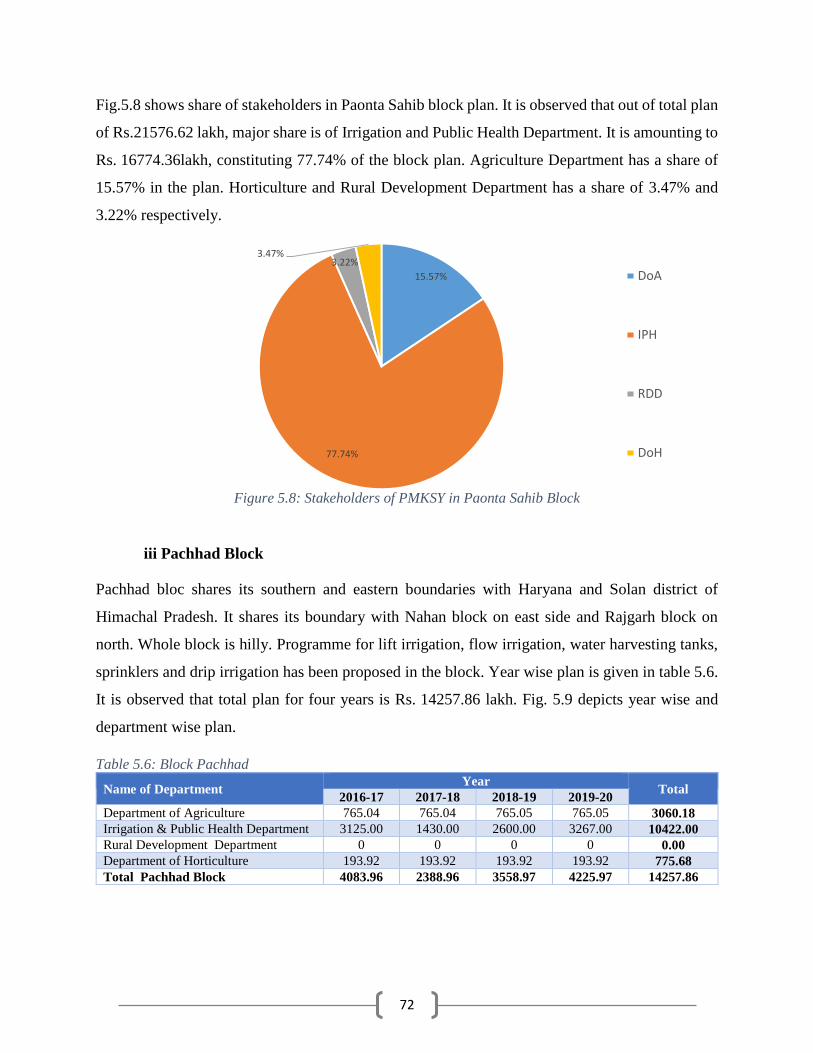
72
Fig.5.8 shows share of stakeholders in Paonta Sahib block plan. It is observed that out of total plan
of Rs.21576.62 lakh, major share is of Irrigation and Public Health Department. It is amounting to
Rs. 16774.36lakh, constituting 77.74% of the block plan. Agriculture Department has a share of
15.57% in the plan. Horticulture and Rural Development Department has a share of 3.47% and
3.22% respectively.
Figure 5.8: Stakeholders of PMKSY in Paonta Sahib Block
iii Pachhad Block
Pachhad bloc shares its southern and eastern boundaries with Haryana and Solan district of
Himachal Pradesh. It shares its boundary with Nahan block on east side and Rajgarh block on
north. Whole block is hilly. Programme for lift irrigation, flow irrigation, water harvesting tanks,
sprinklers and drip irrigation has been proposed in the block. Year wise plan is given in table 5.6.
It is observed that total plan for four years is Rs. 14257.86 lakh. Fig. 5.9 depicts year wise and
department wise plan.
Table 5.6: Block Pachhad
Name of Department Year
Total 2016-17 2017-18 2018-19 2019-20
Department of Agriculture 765.04 765.04 765.05 765.05 3060.18
Irrigation & Public Health Department 3125.00 1430.00 2600.00 3267.00 10422.00
Rural Development Department 0 0 0 0 0.00
Department of Horticulture 193.92 193.92 193.92 193.92 775.68
Total Pachhad Block 4083.96 2388.96 3558.97 4225.97 14257.86
15.57%
77.74%
3.22%3.47%
DoA
IPH
RDD
DoH

73
Figure 5.9: Year-wise and Department wise Plan for Block Pachhad (Rs. in lakh)
Fig.5.10 shows share of stakeholders in Pachhad block plan. It is observed that out of total plan of
Rs. 14257.86 lakh, major share is of Irrigation and Public Health Department. It is amounting to
Rs. 10422.00 lakh, constituting 73.1% of the block plan. Agriculture Department has a share of
21.46% in the plan. Horticulture has a share of 5.44% in the total plan of Pachhad Block.
Figure 5.10: Share of stakeholders in Pachhad block
0.00
500.00
1000.00
1500.00
2000.00
2500.00
3000.00
3500.00
2016-17 2017-18 2018-19 2019-20
Am
ount
in R
s L
akh
DoA IPH RDD DoH
21.46%
73.10%
0.00%5.44%
DoA
IPH
RDD
DoH
74
iv Rajgarh Block
Rajgarh block is the northern most block of the district. Its northern boundary is the district
boundary between Shimla and Sirmour district. It shares its western boundary with Sangrah Block.
Pachhad block is situated to its south and western boundary it shares with Solan district. The block
is hilly and Chur Dhar in the Trans-Giri area is the highest mountain peak of the district having an
altitude of 3,647 meters. Giri River which enters from Solan district passes through the block.
Major parts of the block are hilly & mountainous with highly dissected and undulating terrain.
These areas are underlain by semi-consolidated and consolidated hard rocks of Tertiary and pre-
Tertiary period. Ground water potential in such areas is very low due to its hydro-geomorphic set
up. Springs are the main ground water structures that provide water supply for domestic and
irrigation in major rural and urban areas. Springs are the major ground water sources of water
supply in the district. These springs are mainly gravity, contact or fracture type and springs located
along major thrust/faults or structurally weak planes are high yielding. The springs, locally called
Chasma, have discharges varying from seepages to 15 litres per second. Bowries, a type of dug
well, are another structure constructed in the hill slopes to tap the seepages. Such Bowries are
common and observed in all the southern part of the district. During the last decade, state
government have drilled shallow bore wells fitted with hand-pumps to provide domestic water.
These hand pumps have average depth of 50-60m and have low discharges of around 1 lps.
Programme for lift irrigation, flow irrigation, water harvesting tanks, sprinklers, drip irrigation and
watershed development has been proposed in the block. Year wise plan is given in table 5.6. It is
observed that total plan for four years is Rs. 17407.37 lakh. Fig. 5.11 depicts year wise and
department wise plan.
Table 5.7: Block Rajgarh
Name of Department Year
Total 2016-17 2017-18 2018-19 2019-20
Department of Agriculture 765.04 765.04 765.05 765.05 3060.18
Irrigation & Public Health Department 4039.17 4220.35 2988.19 1642.00 12889.71
Rural Development Department 168.76 168.76 168.76 168.76 675.04
Department of Horticulture 195.61 195.61 195.61 195.61 782.44
Total Rajgarh Block 5168.58 5349.76 4117.61 2771.42 17407.37
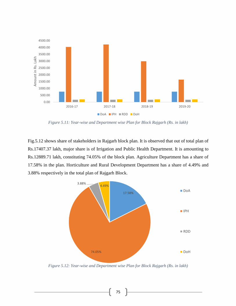
75
Figure 5.11: Year-wise and Department wise Plan for Block Rajgarh (Rs. in lakh)
Fig.5.12 shows share of stakeholders in Rajgarh block plan. It is observed that out of total plan of
Rs.17407.37 lakh, major share is of Irrigation and Public Health Department. It is amounting to
Rs.12889.71 lakh, constituting 74.05% of the block plan. Agriculture Department has a share of
17.58% in the plan. Horticulture and Rural Development Department has a share of 4.49% and
3.88% respectively in the total plan of Rajgarh Block.
Figure 5.12: Year-wise and Department wise Plan for Block Rajgarh (Rs. in lakh)
0.00
500.00
1000.00
1500.00
2000.00
2500.00
3000.00
3500.00
4000.00
4500.00
2016-17 2017-18 2018-19 2019-20
Am
ou
nt
in R
s. L
akh
DoA IPH RDD DoH
17.58%
74.05%
3.88%4.49%
DoA
IPH
RDD
DoH

76
v. Sangrah Block
Sangrah block is situated in the northern side of the district. Its northern boundary is the district
boundary between Shimla and Sirmour district. It shares its eastern boundary with Uttarakhand.
Pachhad and Nahan blocks are situated to its west. Two tehsils namely Renuka and Nohra are
falling in block Sangrah. Major parts of the block are hilly & mountainous with highly dissected
and undulating terrain underlain by semi-consolidated and consolidated hard rocks of Tertiary and
pre-Tertiary period. Ground water potential in such areas is very low due to its hydro-geomorphic
set up. Springs are the main ground water structures that provide water supply for domestic and
irrigation in major rural and urban areas. These springs are mainly gravity, contact or fracture type
and springs located along major thrust/faults or structurally weak planes are high yielding.
Programme for lift irrigation, flow irrigation, water harvesting tanks, sprinklers, drip irrigation and
watershed development has been proposed in the block. Year wise plan is given in table 5.8. It is
observed that total plan for four years is Rs. 16981.93 lakh. Fig. 5.13 depicts year wise and
department wise plan.
Table 5.8: Block Sangrah
Name of Department Year
Total 2016-17 2017-18 2018-19 2019-20
Department of Agriculture 765.04 765.04 765.05 765.05 3060.18
Irrigation & Public Health Department 1171.03 1818.86 1933.06 6150.84 11073.79
Rural Development Department 446.37 446.37 446.37 446.37 1785.48
Department of Horticulture 265.62 265.62 265.62 265.62 1062.48
Total Sangrah Block 2648.06 3295.89 3410.1 7627.88 16981.93
Figure 5.13: Year-wise and Department wise Plan for Block Sangrah (Rs. in lakh)
0.00
1000.00
2000.00
3000.00
4000.00
5000.00
6000.00
7000.00
2016-17 2017-18 2018-19 2019-20
Am
ou
nt
in R
s. L
akh
DoA IPH RDD DoH

77
Fig.5.14 shows share of stakeholders in Sangrah block plan. It is observed that out of total plan of
Rs. 16981.93 lakh, major share is of Irrigation and Public Health Department. It is amounting to
Rs. 11073.79 lakh, constituting 65.21% of the block plan. Agriculture Department has a share of
18.02% in the plan. Rural Development Department and Horticulture department has a share of
10.51% and 6.26% respectively in the total plan of Sangrah Block.
Figure 5.14: Share of stakeholders in Sangrah Block
vi. Shillai Block
Shillai block is situated in the northwestern part of the district. Its northern boundary is the district
boundary between Shimla and Sirmour district. It shares its eastern boundary with Uttarakhand.
Sangrah block is situated to its west. Paonta Sahib Block is situated to its south. Two tehsils namely
Ronhat and Shillai are falling in block Shillai. Major parts of the block are hilly & mountainous
with highly dissected and undulating terrain underlain by semi-consolidated and consolidated hard
rocks. Ground water potential in such areas is very low due to its hydro-geomorphic set up. Springs
are the main ground water structures that provide water supply for domestic and irrigation in major
rural and urban areas. Springs are the major ground water sources of water supply in the district.
These springs are mainly gravity, contact or fracture type and springs located along major
thrust/faults or structurally weak planes are high yielding. The springs, locally called Chasma,
have discharges varying from seepages to 15 litres per second. Bowries, a type of dug well, are
another structure constructed in the hill slopes to tap the seepages. Such Bowries are common and
18.02%
65.21%
10.51%
6.26%
DoA
IPH
RDD
DoH

78
observed in all the southern part of the district. Surface water from streams is being used for
irrigation through flow irrigation and lift irrigation schemes.
Programme for lift irrigation, flow irrigation, water harvesting tanks, sprinklers, drip irrigation and
watershed development has been proposed in the block. Year wise plan is given in table 5.10. It
is observed that total plan for four years is Rs. 11444.40 lakh. Fig. 5.15 depicts year wise and
department wise plan.
Table 5.9: Shillai Block
Department Year
Total 2015-16 2016-17 2017-18 2018-19
Department of Agriculture 765.04 765.04 765.05 765.05 3060.18
Irrigation & Public Health Department 1811.25 1605.71 1576.70 1771.80 6765.46
Rural Development Department 204.23 204.23 204.23 204.23 816.92
Department of Horticulture 200.46 200.46 200.46 200.46 801.84
Total Shillai Block 2980.98 2775.44 2746.44 2941.54 11444.40
Figure 5.15: Year wise and Department wise Plan for Block Shillai (Amt. Rs. in lakh)
Fig.5.16 shows share of stakeholders in Shillai block plan. It is observed that out of total plan of
Rs. 11444.4 lakh, major share is of Irrigation & Public Health Department amounting to Rs.
6765.46 lakh. It is 59.12% of the total block Plan. Agriculture Department plan is amounting to
Rs. 3060.18 lakh, constituting 26.74% of the block plan. Rural Development and Horticulture
departments have a share of 7.14% and 7.01% respectively.
0.00
200.00
400.00
600.00
800.00
1000.00
1200.00
1400.00
1600.00
1800.00
2000.00
2016-17 2017-18 2018-19 2019-20
Am
ou
nt
in R
s. L
akh
DoA IPH RDD DoH

79
Figure 5.16: Share of stakeholders in Shillai Block
5.3 Suggestions
For successful implementation of PMKSY plan it is suggested that:
All the stakeholders should convene meeting of Panchayat Samities and then finalise the
village plan and prepare DPR.
There should not be any duplicity of project.
The Department should supplement each other so that the maximum irrigation efficiency is
achieved.
Agriculture and Horticulture Department should take micro irrigation projects in the
command of minor irrigation projects which are either completed or likely to be completed
in near future.
All the irrigation projects should have a component of water conveyance so that the each
drop of water is judiciously utilized.
Where ever feasible, Solar Pumpsets should be installed.
All the structures planned should be geo tagged and marked on map, so that social
monitoring of the projects can be conducted. This will also avoid the duplicity.
Priority should be given to projects to minimize the gap in potential created and potential
utilized.
26.74%
59.12%
7.14%
7.01%
DoA
IPH
RDD
DoH
80
In Sirmour, many sites with low head LIS have already been exhausted. In such areas, higher
per hectare norms should be allowed.
Execution of the scheme should be expeditiously completed.
There should be smooth fund flow for timely completion of the project and to avoid cost
escalation.
5.6 Expected Outcome
As stated above in earlier Chapters gross cropped area of the district is 73395 ha. of which 24630
ha is irrigated. Thus there is a gap of 48765 ha (gross cropped area) which can be converted from
rainfed to area under assured irrigation. As the water requirement of crops for the existing cropping
pattern works out to be 97.08 MCM and if the gross cropped area is to be brought under irrigated
area, 40.76 MCM additional water is required. Though the water (surface and ground water) is
available in the district yet it will not be feasible to create irrigation potential to the extent of 100%
as the construction of irrigation project may not be economically viable even if it is technically
feasible. In hilly area due to tough terrain, high head, small and fragmented land holdings, per ha.
cost may be very high . Moreover it may not be feasible to develop all the sources within a short
spell of four years for which the plan is being prepared.
Keeping in view the above constraints a plan to develop irrigation potential of 29670 ha has been
proposed. It is proposed to create an irrigation potential by installing new lift irrigation ad Flow
irrigation schemes tapping surface water and installation of tubewells and borewells where ground
water is available. Besides water Harvesting structures have also been proposed to create an
irrigation potential harvesting rainwater as also spring water.
Potential of 12032 ha is proposed to be covered under PMKSY ‘Per drop more crop component’.
Sprinkler and drip irrigation schemes have been proposed under this programme. It is propose to
cover 10700 ha and 1332 ha under sprinkler and drip irrigation schemes respectively. On
completion of these projects, it is expected that an additional irrigation potential of approximately
6000 ha will be created due to saving of water. It is proposed to create 3505 Water Harvesting
Structures which will have a potential of 367425 cubic meter of water to irrigate around 490
hectare of land.
On completion of all the projects proposed under PMKSY 25491 ha of irrigation potential is likely
to be created in the district. On completion of the projects, it is expected that the yield of land

81
currently cultivated under rainfed system will be equal to the yield derived under irrigated land.
Hence, the increase in average yield will be from 39.72 qt per hectare to 45.87 qt per hectare. This
is likely to generate an additional annual income of about Rs 95 crore to the farmers of the district.
It is also expected that 156 lakh mandays of non-recurring employment and 10000 jobs annually
on recurring basis.

82
Annexure –V: Strategic Action Plan for irrigation in respect of District Sirmour under Pradhan Mantri Krishi Sinchayee Yojna (PMKSY)
Sl.
Concerned
Ministry/ Department
Component Activity Total Number/
Capacity (cum)
Command Area/
Irrigation Potential (Ha.)
Period of
Implementation
Fund requirement (in Rs. Lakh) for
2016-17 2017-18 2018-19 2019-20 Total
1 MoWR
AIBP
Major Irrigation
2 MoWR Medium Irrigation
Surface Minor Irrigation
Total
4 MoWR
Har Khet Ko
Pani
Lift Irrigation 172 11508.68 4 8216.97 7280.91 8064.88 9600.53 33163.29
Flow Irrigation 361 7858.75 4 2472.87 5235.15 2956.31 2157 12821.33
5 MoWR Ground Water develpoment 134 1716 4 2058.26 2271.5 2386.5 2373 9089.26
6 MoWR RRR of Water Bodies 244 4687 4 4977.4 3570 1610 4691.14 14848.54
7 MoWR Construction of field channels
7.1 MoWR Lined Field Channels
7.2 MoWR Unlined Field Channels
8 MoWR Micro-Irrigation 2230 1960 4 939.5 939.5 939.5 939.5 3758
Total 3141 27730.43 18665 19297.06 15957.19 19761.17 73680.42
9 MOA & FW-
DAC & FW
Per drop more crop (Micro
Irrigation)
DPAP Drip 1800 900
4 80.41 80.41 80.41 80.41 321.64
10 MOA & FW-DAC & FW
DPAP Sprinkler 2400 1200
4 192.12 192.12 192.12 192.12 768.48
11 MOA & FW-
DAC & FW Non- DPAP Drip 1080 432 4 297 297 297 297 1188
12 MOA & FW-DAC & FW
Non- DPAP Sprinkler 19000 9500 4 1425 1425 1425 1425 5700
PMDMC MI Total 1994.53 1994.53 1994.53 1994.53 7978.12
13 MOA & FW-
DAC & FW
Per drop more
crop Topping up of MGNREGA 0 0 4 0 0 0 0 0
14 MOA & FW-
DAC & FW
(Supplementary
water
management activities)
Drought Proofing through check Dams/Water
Harvesting Structures
4800 2400 4 900 900 900 900 3600
15 MOA & FW-DAC & FW
Secondary Storage Structure 2040 2040 4 765 765 765 765 3060
16 MOA & FW-DAC & FW
On Farm Development
(distribution pipe / raised
bed and furrow system etc.)
960000 1200 4 300 300 300 300 1200
PDMC SWMA Total 1965 1965 1965 1965 7860
Extension and Training
(ATMA) 78.24 78.24 78.30 78.30 313.08
PDMC Total 4037.77 4037.77 4037.83 4037.83 16151.2
17 DoLR-MoRD
PMKSY
Watershed
Newly created WHS
17 DoLR-MoRD Farm Ponds 405 22129 4 103.99725 103.99725 103.99725 103.99725 415.989
17 DoLR-MoRD Check Dams 332 7443 4 22.043 22.043 22.043 22.043 88.172
17 DoLR-MoRD Nallah Bunds 58 369 4 9.4 9.4 9.4 9.4 37.6
17 DoLR-MoRD Percolation Tank 173 6296 4 24.52 24.52 24.52 24.52 98.08

83
18 DoLR-MoRD Other Ground Water
Recharge structure 1021 13162 4 253.4885 253.4885 253.4885 253.4885 1013.954
18 DoLR-MoRD Fishery Ponds/cattle Ponds 1 125 4 0.5 0.5 0.5 0.5 2
18 DoLR-MoRD Renovated WHS
18 DoLR-MoRD Farm Ponds 14/2210 4 1.75 1.75 1.75 1.75 7
18 DoLR-MoRD Check Dams
18 DoLR-MoRD Nallah Bunds
18 DoLR-MoRD Percolation Tank
19 DoLR-MoRD Other Ground Water
Recharge structure 21/2250 4 2.5625 2.5625 2.5625 2.5625 10.25
19 DoLR-MoRD Fishery Ponds/cattle Ponds
Land Development 4 66.945 66.945 66.945 66.945 267.78
Administration, Capacity
Building & other expenses 431.80 431.80 431.80 431.80 1727.20
Watershed Total 917.007 917.007 917.007 917.007 3668.028
19 DoRD-MoRD
Convergence
with MGNREGA
Newly Created
19 DoRD-MoRD Water Conservation 0 0 0 0 0 0 0 0
19 DoRD-MoRD Water Harvesting 54/5935 Cum 531 4 57.25 57.25 57.25 57.25 229
19 DoRD-MoRD Creation of Irrigation canals
& Drains 124/150760 mtr 1190 4 214.25 214.25 214.25 214.25 857
19 DoRD-MoRD Providing Infrastructure for Irrigation
20 DoRD-MoRD Renovation
20 DoRD-MoRD Renovation of water bodies
including desilting:
20 DoRD-MoRD
Renovation & Maintenance
of Irrigation Canals & Drains
Convergence Total 271.5 271.5 271.5 271.5 1086
District Total 23891.28 24523.34 21183.53 24987.51 94585.63

84
Department wise/ Block wise/ Component wise Strategic Action Plan for irrigation in respect of District Sirmour under Pradhan Mantri Krishi Sinchayee Yojna (PMKSY)
Sl. Blocks Ministry Component Activity No./ Cap
(Cum)
CA/IP
(Ha)
Years Estimated cost (Rs. in lacs)
2016-17 2017-18 2018-19 2019-20 Total
Details of PMKSY programme to be implemented by Irrigation and Public Health Department
1 Nahan MoWR AIBP Major Irrigation
2 Rajgarh MoWR Medium Irrigation
3 Nahan MoWR Surface Minor Irrigation (Flow Irrigation)
Paonta
Pachhad
Sangrah
Shillai
Total
4 Nahan MoWR Har Khet ko pani
Lift Irrigation 33 1968.21 4 3352.29 1255.14 614.14 610.00 5831.57
Paonta 17 2072 4 1025.00 2340.00 1480.00 1700.00 6545.00
Pachhad 35 1936 4 350.00 1130.00 2400.00 3222.00 7102.00
Rajgarh 44 2845.47 4 2321.57 1035.60 1031.79 305.00 4693.96
Sangrah 26 1663.09 4 739.26 532.46 1542.25 3233.53 6047.50
Shillai 17 1023.91 4 428.85 987.71 996.70 530.00 2943.26
Total 172 11508.68 8216.97 7280.91 8064.88 9600.53 33163.29
5 Shillai Ground Water
Development 1 118 3 113.26 226.50 226.50 0.00 566.26
Paonta MoWR 133 1598 4 1945.00 2045.00 2160.00 2373.00 8523.00
Total 134 1716 2058.26 2271.50 2386.50 2373.00 9089.26
5a Nahan MoWR Flow Irrigation 11 232.48 4 218.50 101.00 109.00 178.00 606.50
Paonta 3 1357 1 25.00 245.00 220.10 130.00 620.10
Pachhad 2 58 2 0.00 100.00 0.00 45.00 145.00
Rajgarh 33 1891 4 517.60 1984.75 756.40 120.00 3378.75
Sangrah 24 925.27 4 431.77 1286.40 390.81 189.00 2297.98
Shillai 48 995 4 380.00 618.00 580.00 595.00 2173.00
Total 121 5458.75 1572.87 4335.15 2056.31 1257.00 9221.33
6 Nahan MoWR RRR of Water Bodies 27 496 1 0.00 1960.00 0.00 0.00 1960.00
Paonta 9 170 3 0.00 210.00 210.00 100.00 520.00
Pachhad 9 1270 3 2775.00 200.00 200.00 0.00 3175.00
Rajgarh 139 1693 4 1200.00 1200.00 1200.00 1217.00 4817.00
Sangrah 40 506 1 0.00 0.00 0.00 2727.34 2727.34
Shillai 20 552 2 1002.40 0.00 0.00 646.80 1649.20
Total 244 4687 4977.40 3570.00 1610.00 4691.14 14848.54
Grand Total Irrigation & Public Health Department 671 23370.43 16825.50 17457.56 14117.69 17921.67 66322.42
Details of PMKSY programme to be implemented by Agriculture Department
5a Nahan MoWR Har Khet ko
pani
Flow Irrigation 40 400 4 150 150 150 150 600
Paonta 40 400 4 150 150 150 150 600
Pachhad 40 400 4 150 150 150 150 600
Rajgarh 40 400 4 150 150 150 150 600
Sangrah 40 400 4 150 150 150 150 600
Shillai 40 400 4 150 150 150 150 600
Total 240 2400 900 900 900 900 3600
11 Nahan MOA &
FW-DAC&FW
Non-DPAP Drip 180 72 4 49.50 49.50 49.50 49.50 198.00
Paonta 180 72 4 49.50 49.50 49.50 49.50 198.00
Pachhad 180 72 4 49.50 49.50 49.50 49.50 198.00
Rajgarh 180 72 4 49.50 49.50 49.50 49.50 198.00
Sangrah 180 72 4 49.50 49.50 49.50 49.50 198.00
Shillai 180 72 4 49.50 49.50 49.50 49.50 198.00
Total 1080 432 297.00 297.00 297.00 297.00 1188.00
12 Nahan Non-DPAP Sprinkler 3000 1500 4 225.00 225.00 225.00 225.00 900.00
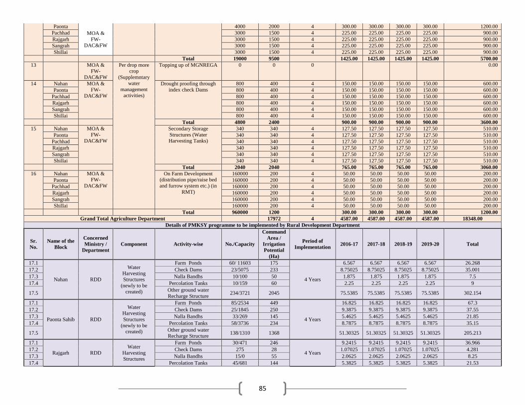
85
Paonta
MOA &
FW-
DAC&FW
4000 2000 4 300.00 300.00 300.00 300.00 1200.00
Pachhad 3000 1500 4 225.00 225.00 225.00 225.00 900.00
Rajgarh 3000 1500 4 225.00 225.00 225.00 225.00 900.00
Sangrah 3000 1500 4 225.00 225.00 225.00 225.00 900.00
Shillai 3000 1500 4 225.00 225.00 225.00 225.00 900.00
Total 19000 9500 1425.00 1425.00 1425.00 1425.00 5700.00
13 MOA &
FW-DAC&FW
Per drop more
crop (Supplemntary
water
management activities)
Topping up of MGNREGA 0 0 0 0.00
14 Nahan MOA &
FW-DAC&FW
Drought proofing through
index check Dams
800 400 4 150.00 150.00 150.00 150.00 600.00
Paonta 800 400 4 150.00 150.00 150.00 150.00 600.00
Pachhad 800 400 4 150.00 150.00 150.00 150.00 600.00
Rajgarh 800 400 4 150.00 150.00 150.00 150.00 600.00
Sangrah 800 400 4 150.00 150.00 150.00 150.00 600.00
Shillai 800 400 4 150.00 150.00 150.00 150.00 600.00
Total 4800 2400 900.00 900.00 900.00 900.00 3600.00
15 Nahan MOA &
FW-DAC&FW
Secondary Storage
Structures (Water Harvesting Tanks)
340 340 4 127.50 127.50 127.50 127.50 510.00
Paonta 340 340 4 127.50 127.50 127.50 127.50 510.00
Pachhad 340 340 4 127.50 127.50 127.50 127.50 510.00
Rajgarh 340 340 4 127.50 127.50 127.50 127.50 510.00
Sangrah 340 340 4 127.50 127.50 127.50 127.50 510.00
Shillai 340 340 4 127.50 127.50 127.50 127.50 510.00
Total 2040 2040 765.00 765.00 765.00 765.00 3060.00
16 Nahan MOA & FW-
DAC&FW
On Farm Development (distribution pipe/raise bed
and furrow system etc.) (in
RMT)
160000 200 4 50.00 50.00 50.00 50.00 200.00
Paonta 160000 200 4 50.00 50.00 50.00 50.00 200.00
Pachhad 160000 200 4 50.00 50.00 50.00 50.00 200.00
Rajgarh 160000 200 4 50.00 50.00 50.00 50.00 200.00
Sangrah 160000 200 4 50.00 50.00 50.00 50.00 200.00
Shillai 160000 200 4 50.00 50.00 50.00 50.00 200.00
Total 960000 1200 300.00 300.00 300.00 300.00 1200.00
Grand Total Agriculture Department 17972 4 4587.00 4587.00 4587.00 4587.00 18348.00
Details of PMKSY programme to be implemented by Rural Development Department
Sr.
No.
Name of the
Block
Concerned
Ministry /
Department
Component Activity-wise No./Capacity
Command
Area /
Irrigation
Potential
(Ha)
Period of
Implementation 2016-17 2017-18 2018-19 2019-20 Total
17.1
Nahan RDD
Water
Harvesting Structures
(newly to be
created)
Farm Ponds 60/ 11603 175
4 Years
6.567 6.567 6.567 6.567 26.268
17.2 Check Dams 23/5075 233 8.75025 8.75025 8.75025 8.75025 35.001
17.3 Nalla Bandhs 10/100 50 1.875 1.875 1.875 1.875 7.5
17.4 Percolation Tanks 10/159 60 2.25 2.25 2.25 2.25 9
17.5 Other ground water
Recharge Structure 234/3721 2045 75.5385 75.5385 75.5385 75.5385 302.154
17.1
Paonta Sahib RDD
Water Harvesting
Structures
(newly to be created)
Farm Ponds 85/2534 449
4 Years
16.825 16.825 16.825 16.825 67.3
17.2 Check Dams 25/1845 250 9.3875 9.3875 9.3875 9.3875 37.55
17.3 Nalla Bandhs 33/269 145 5.4625 5.4625 5.4625 5.4625 21.85
17.4 Percolation Tanks 58/3736 234 8.7875 8.7875 8.7875 8.7875 35.15
17.5 Other ground water Recharge Structure
138/1310 1368 51.30325 51.30325 51.30325 51.30325 205.213
17.1
Rajgarh RDD
Water
Harvesting Structures
Farm Ponds 30/471 246
4 Years
9.2415 9.2415 9.2415 9.2415 36.966
17.2 Check Dams 275 28 1.07025 1.07025 1.07025 1.07025 4.281
17.3 Nalla Bandhs 15/0 55 2.0625 2.0625 2.0625 2.0625 8.25
17.4 Percolation Tanks 45/681 144 5.3825 5.3825 5.3825 5.3825 21.53

86
17.5 (newly to be
created)
Other ground water
Recharge Structure 469/7035 1897 71.15225 71.15225 71.15225 71.15225 284.609
17.1
Sangrah RDD
Water
Harvesting Structures
(newly to be
created)
Farm Ponds 141/5741 1278
4 Years
47.92625 47.92625 47.92625 47.92625 191.705
17.2 Check Dams 2/173 20 0.7725 0.7725 0.7725 0.7725 3.09
17.4 Percolation Tanks 13/780 26 0.975 0.975 0.975 0.975 3.9
17.5 Other ground water
Recharge Structure 24/150 204 29.5945 29.5945 29.5945 29.5945 118.378
17.1
Shillai RDD
Water Harvesting
Structures
(newly to be created)
Farm Ponds 89/1780 445
4 Years
23.4375 23.4375 23.4375 23.4375 93.75
17.2 Check Dams 7/350 48 2.0625 2.0625 2.0625 2.0625 8.25
17.4 Percolation Tanks 47/940 157 7.125 7.125 7.125 7.125 28.5
17.5 Other ground water Recharge Structure
156/946 624 25.9 25.9 25.9 25.9 103.6
17.6 Fishry Ponds / Cattle Ponds 1/125 0 0.5 0.5 0.5 0.5 2
18 Block Department Component Activity-wise No. CA/IP
(Ha)
Years 2016-17 2017-18 2018-19 2019-20
Estimated Cost in Rs.
in Lac
18.5
Nahan RDD
Water
Harvesting Structures to be
Renovated
Other Ground Water Recharge Structure
10/150 28 1.0625 1.0625 1.0625 1.0625 4.25
18.7
(A)
Land
Development 240 8.98525 8.98525 8.98525 8.98525 35.941
18.7
(B)
Soil and Moisture
Conservation
168 6.297 6.297 6.297 6.297 25.188
18.7
(E) I & CB -
No./
Participant
Name of
Institute Yr
Estimated Cost in Rs.
in Lac
20/980 4 Years 6.3375 6.3375 6.3375 6.3375 25.35
18.7 (F)
- No./
Beneficiaries Yr
Estimated Cost in Rs. in Lac
Livelihood
85/659 (7
SHGs to be
formed)
4 Years 20.609 20.609 20.609 20.609 82.436
Production &
Micro
Enterprises
65/995 4 Years 21.8145 21.8145 21.8145 21.8145 87.258
Monitoring 4 Years 2.81025 2.81025 2.81025 2.81025 11.241
Evaluation 4 Years 2.67675 2.67675 2.67675 2.67675 10.707
Consolidation 4 Years 8.4525 8.4525 8.4525 8.4525 33.81
18.7
(K) Administration 4 Years 21.56575 21.56575 21.56575 21.56575 86.263
18
Paonta
Sahib RDD
Activity-wise No./Cap CA/IP
(Ha) Yr 2016-17 2017-18 2018-19 2019-20
Estimated Cost in Rs.
in Lac
18.5
Water
Harvesting
Structures to be Renovated
Other Ground Water
Recharge Structure 7/140 27 4 Years 1 1 1 1 4
18.7
(A)
Land
Development 262 9.82825 9.82825 9.82825 9.82825 39.313
18.7
(B)
Soil and
Moisture Conservation
2.45 2.45 2.45 2.45 9.8
18.7
(E) I & CB
- No./
Participant
Name of
Institute Yr
Estimated Cost in Rs.
in Lac
16/960 4 Years 3.82125 3.82125 3.82125 3.82125 15.285

87
Component - No./
Beneficiaries - Yr
Estimated Cost in Rs.
in Lac
18.7
(F) Livelihood 65/832 4 Years 18.3095 18.3095 18.3095 18.3095 73.238
18.7
(G)
Production & Micro
Enterprises
212/928 4 Years 18.294 18.294 18.294 18.294 73.176
18.7
(H) Monitoring 2.233 2.233 2.233 2.233 8.932
18.7
(I) Evaluation 2.15 2.15 2.15 2.15 8.6
18.7
(J) Consolidation 6.79 6.79 6.79 6.79 27.16
18.7
(K) Administration 16.917 16.917 16.917 16.917 67.668
18.1
Rajgarh RDD
Activity-wise No./Cap CA/IP
(Ha) Yr 2016-17 2017-18 2018-19 2019-20
Estimated Cost in Rs.
in Lac
Water
Harvesting
Structures to be Renovated
Farm Ponds Apr-60 16 4 Years 0.625 0.625 0.625 0.625 2.5
18.5 Other Ground Water
Recharge Structure Apr-60 4 Years 0.5 0.5 0.5 0.5 2
18.7
(A)
Land
Development 236 8.8715 8.8715 8.8715 8.8715 35.486
18.7
(B)
Soil and
Moisture Conservation
66 2.49375 2.49375 2.49375 2.49375 9.975
18.7 (E)
I & CB -
No./
Participant
Name of
Institute Yr
Estimated Cost in Rs.
in Lac
25/1235 4 Years 5.414 5.414 5.414 5.414 21.656
Component - No./
Beneficiaries SHG Yr
Estimated Cost in Rs.
in Lac
18.7
(F) Livelihood 55/1032 5 4 Years 16.4305 16.4305 16.4305 16.4305 65.722
18.7
(G)
Production &
Micro Enterprises
64/1228 4 Years 19.033 19.033 19.033 19.033 76.132
18.7
(H) Monitoring 4 Years 2.104 2.104 2.104 2.104 8.416
18.7
(I) Evaluation 4 Years 1.97625 1.97625 1.97625 1.97625 7.905
18.7 (J)
Consolidation 4 Years 6.355 6.355 6.355 6.355 25.42
18.7
(K) Administration 4 Years 16.0495 16.0495 16.0495 16.0495 64.198
18.1
Sangrah RDD
Component Activity-wise
No./
Capacity
(cum)
CA/P Yr 2016-17 2017-18 2018-19 2019-20 Estimated Cost in Rs.
in Lac
Water
Harvesting
Structures to be Renovated
Farm Ponds 10/250 30 4 Years 1.125 1.125 1.125 1.125 4.5
18.7
(A)
Land
Development 369 4 Years 13.825 13.825 13.825 13.825 55.3

88
18.7
(B)
Soil and
Moisture
Conservation 167 4 Years 6.25 6.25 6.25 6.25 25
18.7
(E) I & CB
- No./
Participant Name of
Institute Yr
Estimated Cost in Rs.
in Lac
23/2235 4 Years 6.18725 6.18725 6.18725 6.18725 24.749
Component - No./
Beneficiaries - Yr
Estimated Cost in Rs.
in Lac
18.7
(F) Livelihood 31/1126 4 Years 18.12575 18.12575 18.12575 18.12575 72.503
18.7
(G)
Production &
Micro
Enterprises
35/1258 4 Years 20.8525 20.8525 20.8525 20.8525 83.41
18.7
(H) Monitoring 4 Years 2.22875 2.22875 2.22875 2.22875 8.915
18.7
(I) Evaluation 4 Years 2.1 2.1 2.1 2.1 8.4
18.7
(J) Consolidation 4 Years 6.75 6.75 6.75 6.75 27
18.7
(K) Administration 4 Years 18.155 18.155 18.155 18.155 72.62
18
Shillai RDD
Component Activity-wise No./Cap CA/IP
(Ha) Yr 2016-17 2017-18 2018-19 2019-20
Estimated Cost in Rs.
in Lac
18.7
(A)
Land
Development 678 25.435 25.435 25.435 25.435 101.74
18.7
(B)
Soil and
Moisture
Conservation
1017 38.15275 38.15275 38.15275 38.15275 152.611
18.7
(E) I & CB
- No./
Participant Name of
Institute Yr
Estimated Cost in Rs.
in Lac
25/2613 4 Years 9.25125 9.25125 9.25125 9.25125 37.005
18.7
(F) Component -
No./ Beneficiaries
- Yr Estimated Cost in Rs.
in Lac
Livelihood 28/1236 4 Years 19.2525 19.2525 19.2525 19.2525 77.01
18.7
(G)
Production &
Micro
Enterprises
26/1527 4 Years 22.177 22.177 22.177 22.177 88.708
18.7
(H) Monitoring 4 Years 2.271 2.271 2.271 2.271 9.084
18.7
(I) Evaluation 4 Years 2.271 2.271 2.271 2.271 9.084
18.7
(J) Consolidation 4 Years 6.8125 6.8125 6.8125 6.8125 27.25
18.7
(K) Administration 4 Years 19.5795 19.5795 19.5795 19.5795 78.318
Total
17-
18
Nahan DolR-
MoRD
PMKSY
Watershed
Detail as above
4 195.59 195.59 195.59 195.59 782.36
Paonta 4 173.56 173.56 173.56 173.56 694.24
Shillai 4 204.23 204.23 204.23 204.23 816.92
Sangrah 4 174.87 174.87 174.87 174.87 699.48
Rajgarh 4 168.76 168.76 168.76 168.76 675.04
Pachhad 0 0 0 0 0
Total 917.01 917.01 917.01 917.01 3668.04
19 Sangrah DolR-
MoRD
Newly created
19.1 Water Conservation:

89
19.2 Convergence
with MGNREGA
Water harvesting 54/5935 Cum 531 4 57.25 57.25 57.25 57.25 229
19.3 Creation of Irrigation Canals and Drains:
124/150760 mtr
1190 4 214.25 214.25 214.25 214.25 857
Total 178 1721 271.5 271.5 271.5 271.5 1086
Grand Total Rural Development Department 1188.51 1188.51 1188.51 1188.51 4754.04
Details of PMKSY programme to be implemented by Horticulture Department
a Nahan MoWR Har khet ko pani
Community Water Tanks 10 nos./ 15000 cub.m.
Capacity
5 4 12.50 12.50 12.50 12.50 50.00
Paonta 10 nos./
15000 cub.m. Capacity
5 4 12.50 12.50 12.50 12.50 50.00
c Pachhad 40
nos./60000 cub.m.
Capacity
20 4 50.00 50.00 50.00 50.00 200.00
Rajgarh 40
nos./60000 cub.m.
Capacity
20 4 50.00 50.00 50.00 50.00 200.00
Sangrah 40 nos./ 60000 cub.m.
Capacity
20 4 50.00 50.00 50.00 50.00 200.00
Shillai 40 nos./
60000 cub.m. Capacity
20 4 50.00 50.00 50.00 50.00 200.00
Total 180 90 225 225 225 225 900
Nahan Water Tank 200 nos./ 10000 cub.m.
200 4 70.00 70.00 70.00 70.00 280.00
Paonta 70 nos./
3500 cub.m.
70 4 24.50 24.50 24.50 24.50 98.00
Pachhad 200 nos. /10000
cub.m.
200 4 70.00 70.00 70.00 70.00 280.00
Rajgarh 200 nos./
10000 cub.m.
200 4 70.00 70.00 70.00 70.00 280.00
Sangrah 400 nos./
0000 cub.m.
400 4 140.00 140.00 140.00 140.00 560.00
Shillai 200 nos./
10000 cub.m.
200 4 70.00 70.00 70.00 70.00 280.00
Total 1450 1270 444.50 444.50 444.50 444.50 1778.00
Nahan Borewell* 100 100 4 45.00 45.00 45.00 45.00 180.00
Paonta 240 240 4 108.00 108.00 108.00 108.00 432.00
Pachhad 60 60 4 27.00 27.00 27.00 27.00 108.00
Rajgarh 60 60 4 27.00 27.00 27.00 27.00 108.00
Sangrah 60 60 4 27.00 27.00 27.00 27.00 108.00
Shillai 80 80 4 36.00 36.00 36.00 36.00 144.00
Total 600 600 270 270 270 270 1080
Nahan MOA &
FW-DAC&FW
Per drop more
crop (Micro Irrigation)
Drip Irrigation (Citrus
Crops)
200 100 4 9.94 9.94 9.94 9.94 39.76
Paonta Drip Irrigation (Citrus Crops)
200 100 4 9.94 9.94 9.94 9.94 39.74
Pachhad Drip Irrigation (Plum,
Peach orchard)
300 150 4 14.90 14.90 14.90 14.90 59.60

90
Rajgarh Drip Irrigation (Apple
orchard)
400 200 4 16.60 16.60 16.60 16.60 66.38
Sangrah Drip Irrigation (Plum,
Peach orchard)
400 200 4 16.60 16.60 16.60 16.60 66.38
Shillai Drip Irrigation (Apple
Crops)
300 150 4 12.45 12.45 12.45 12.45 49.78
Total 1800 900 80.41 80.41 80.41 80.41 321.64
Nahan Sprinkler Irrigation 400 200 4 32.02 32.02 32.02 32.02 128.08
Paonta 400 200 4 32.02 32.02 32.02 32.02 128.08
Pachhad 400 200 4 32.02 32.02 32.02 32.02 128.08
Rajgarh 400 200 4 32.02 32.02 32.02 32.02 128.08
Sangrah 400 200 4 32.02 32.02 32.02 32.02 128.08
Shillai 400 200 4 32.02 32.02 32.02 32.02 128.08
Total 2400 1200 192.12 192.12 192.12 192.12 768.48
Grand Total Horticulture Department 6430 4060 4 1212.03 1212.03 1212.03 1212.03 4848.12
Other loan projects like NABARD
25 Nahan NABARD
Aided projects
Har khet ko
pani
RWH cum Check Dams
And LIS
3 287.85 3 43.56 87.14 87.14 0.00 217.84
Paonta T/Well 1 118 3 113.26 226.50 226.50 0.00 566.26
Shillai LIS 2 116.91 3 68.85 137.71 137.70 0.00 344.26
Grand Total NABARD RIDF 6 522.76 225.67 451.35 451.34 0.00 1128.36
Extension and Training -ATMA
9 to 16
Nahan MOA & FW-
DAC&FW
Per drop more crop(Micro
irrigation and
Supplementry water
Management
activities)
Training and Extension- ATMA
13.04 13.04 13.05 13.05 52.18
Paonta 13.04 13.04 13.05 13.05 52.18
Pachhad 13.04 13.04 13.05 13.05 52.18
Rajgarh 13.04 13.04 13.05 13.05 52.18
Sangrah 13.04 13.04 13.05 13.05 52.18
Shillai 13.04 13.04 13.05 13.05 52.18
Grand Total ATMA 78.24 78.24 78.30 78.30 313.08
Total PMKSY Plan of Sirmour District 7107.00 45925.19 24116.95 24974.69 21634.87 24987.51 94585.66
Block-Wise Strategic Action Plan For Per Drop More Crop - Supplementary Water Management Activities PMKSY of Sirmaur District as per MIS format of GOI.
Sl.
No
Name
of
Block
Component Activity
Total
Number
Pondage
Capacity
(Cum)
Command Area/
Irrigation Potential
(Hect.)
Period Of
Completion
Estt. Cost (Lac.)
1
Na
ha
n
Per Drop More Crop
Supplementary water
management Activities
Topping Up of MGNREGA 0 0 0.00 5 Years 0.00
Drought proofing through check dam /water
harvesting structure 800 200000 400.00 5Years 600.00
Secondary Storage Structure 340 6800 340.00 5Years 510.00
On Farm Development Distributions of
pipes Raised Beds & Furrow Systems 16000 200.00 5 years 200.00
Total 17140 206800 940.00 1310.00
2
Pa
on
ta
Per Drop More Crop
Supplementary water
management Activities
Topping Up of MGNREGA 0 0 0.00 0 0.00
Drought proofing through check dam /water
harvesting structure 800 200000 400.00 5Years 600.00
Secondary Storage Structure 340 680 340.00 5Years 510.00
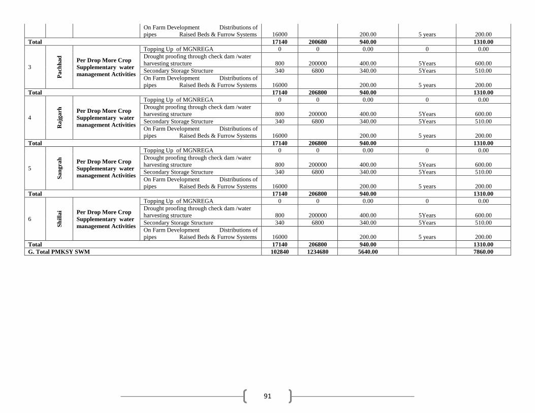
91
On Farm Development Distributions of
pipes Raised Beds & Furrow Systems 16000 200.00 5 years 200.00
Total 17140 200680 940.00 1310.00
3
Pa
chh
ad
Per Drop More Crop
Supplementary water
management Activities
Topping Up of MGNREGA 0 0 0.00 0 0.00
Drought proofing through check dam /water
harvesting structure 800 200000 400.00 5Years 600.00
Secondary Storage Structure 340 6800 340.00 5Years 510.00
On Farm Development Distributions of
pipes Raised Beds & Furrow Systems 16000 200.00 5 years 200.00
Total 17140 206800 940.00 1310.00
4
Ra
jga
rh
Per Drop More Crop
Supplementary water
management Activities
Topping Up of MGNREGA 0 0 0.00 0 0.00
Drought proofing through check dam /water
harvesting structure 800 200000 400.00 5Years 600.00
Secondary Storage Structure 340 6800 340.00 5Years 510.00
On Farm Development Distributions of
pipes Raised Beds & Furrow Systems 16000 200.00 5 years 200.00
Total 17140 206800 940.00 1310.00
5
Sa
ng
rah
Per Drop More Crop
Supplementary water
management Activities
Topping Up of MGNREGA 0 0 0.00 0 0.00
Drought proofing through check dam /water
harvesting structure 800 200000 400.00 5Years 600.00
Secondary Storage Structure 340 6800 340.00 5Years 510.00
On Farm Development Distributions of
pipes Raised Beds & Furrow Systems 16000 200.00 5 years 200.00
Total 17140 206800 940.00 1310.00
6
Sh
illa
i Per Drop More Crop
Supplementary water
management Activities
Topping Up of MGNREGA 0 0 0.00 0 0.00
Drought proofing through check dam /water
harvesting structure 800 200000 400.00 5Years 600.00
Secondary Storage Structure 340 6800 340.00 5Years 510.00
On Farm Development Distributions of
pipes Raised Beds & Furrow Systems 16000 200.00 5 years 200.00
Total 17140 206800 940.00 1310.00
G. Total PMKSY SWM 102840 1234680 5640.00 7860.00


