
DEVELOPMENT OF THE CARBONATE ISLANDKARST MODEL
JOAN R. MYLROIE AND JOHN E. MYLROIEDepartment of Geosciences, Mississippi State University, Mississippi State, MS 39762 USA, [email protected]
Abstract: The development of a comprehensive conceptual model for carbonate island
karst began in the Bahamas in the 1970s. The use, initially, of cave and karst models
created for the interior of continents, on rocks hundreds of millions of years old, was not
successful. Models developed in the 1980s for the Bahamas, that recognized the
youthfulness of the carbonate rock, the importance of fresh-water mixing with sea water,
and the complications introduced by glacioeustatic sea-level change produced the firstviable model, the flank margin cave model. This model explains the largest caves in
carbonate islands as being the result of mixing zone dissolution in the distal margin of the
fresh-water lens, under the flank of the enclosing land mass. The flank margin model,
taken from the Bahamas to Isla de Mona, Puerto Rico, in the early 1990s, provided the
first viable explanation for the very large caves there. Field work in the geologically-
complex Mariana Islands in the late 1990s resulted in the development of the Carbonate
Island Karst Model, or CIKM, which integrated the various components controlling
cave and karst development on carbonate islands. These components are: 1) Mixing offresh and salt water to create dissolutional aggressivity; 2) Movement of the fresh-water
lens, and hence the mixing environments, by 100+ m as a result of Quaternary
glacioeustasy; 3) The overprinting of glacioeustatic changes by local tectonic movements,
where present; 4) The unique behavior of eogenetic (diagenetically immature) carbonate
rocks; and 5) The classification of carbonate islands into simple, carbonate cover,
composite, and complex categories. Current research involves the use of flank margin
caves as predictors of past and present fresh-water lens configuration, the analysis of
flank margin cave morphology as a measure of the processes that create them, and theCIKM as an indicator of paleokarst distribution.
INTRODUCTION
This paper is designed to present to the National
Speleological Society reader an understanding of the
unique and unusual types of caves and karst that form in
tropical carbonate islands. It will also summarize how, for
the last 35 years, we have pursued island caves around the
world, and attempted to figure out why they are there, and
how they formed. Given that it has been 40 years since the
JCKS published an anniversary issue such as this one, the
time frame is about right to present a review article that
takes the reader through the development of ideas about
caves and karst on islands, and what we understand today.
The research began in the Bahamas, which as will be seen,
was fortuitous as they represent some of the simplest
carbonate islands that can be found anywhere. (We use the
term carbonate island, instead of limestone island, to take
note that the rocks we are dealing with contain three
carbonate minerals: calcite and aragonite which are
different forms (or polymorphs) of calcium carbonate,
CaCO3; and dolomite, a calcium-magnesium carbonate,
CaMg(CO3)2.)
We explored and mapped (crudely) our first island cave,
Hunt’s Cave on New Providence Island, Bahamas, while
on a tourist visit in 1971. As northeastern U.S. cavers, we
found the heat of the caves and the ever-present biota,
especially cockroaches, to be quite a shock (we came back
in 1990 and mapped it properly). In 1974 we accompanied
Art and Peg Palmer, of Oneonta State University, to
Bermuda at the invitation of Mike Queen (then at the
Bermuda Biological Station), to map caves and to examine
the unusual karst processes in operation. As it turned out,
Bermuda caves are somewhat unique, even among island
caves, and the team could not agree on how the caves were
forming. Beginning in 1976, we began making annual field
trips with James Carew, now at the College of Charleston,
and our students to the Bahamas, first to North Andros
Island in 1976, then to San Salvador Island from 1977 to
the present. The hook was set, and we have been captivated
and intrigued by island caves ever since. The research
began as a two steps forward, one step backward
experience as our ignorance of island karst processes
was slowly replaced by a growing appreciation for the
specialized environment we were observing.
EARLY RESEARCH
For over a decade we applied the models and theories of
cave development established by research on continental
caves to the caves of the Bahamas, and we had little luck in
J.R. Mylroie and J.E. Mylroie – Development of the carbonate island karst model. Journal of Cave and Karst Studies, v. 69, no. 1, p. 59–75.
Journal of Cave and Karst Studies, April 2007 N 59
understanding what was going on. In 1991, Palmer (1991)
described two major classifications of caves: epigenic caves
that are coupled to the surface hydrology, and commonly
have sinking streams, caves as turbulent flow conduits, and
springs. The second classification was hypogenic, meaning
that the cave formed by dissolution in the subsurface as
a result of mixing of waters of different chemistry; these
caves lack sinking stream inputs or conduits carrying
turbulent flow to discrete springs because they are
uncoupled from the surface hydrology. Our initial inves-
tigations treated the caves of the Bahamas as epigenic in
type, although the term hadn’t been published yet. We then
began to consider what was unique about the island setting,
and started to back away from continental theories. We
recognized that sea level controlled the position of the
fresh-water lens in islands, but we still were conceptually
tied to the idea of continental stream caves (Carew et al.,
1982; Mylroie, 1983; Mylroie and Carew, 1988a). Some of
these ideas, in hindsight, are quite amusing. We also
generated some papers, based on amino acid racemization
(AAR) dating of rocks in the Bahamas, that attempted to
portray cave development as occurring in very short
time periods (Mylroie and Carew, 1986a, 1986b, 1987). It
turns out that we were correct about the rapid cave
development, we just had the wrong time window in the
Quaternary because of the bad dates from the AAR work
(see Carew and Mylroie, 1997, for a discussion of the AAR
problem).
Palmer et al. (1977), drawing on the geochemical work
of Bogli (1964, in Bogli 1980) and Plummer (1975), had
advanced a theory that mixing of marine and fresh waters
under carbonate islands could create an environment of
enhanced dissolution, and so explain cave development on
Bermuda. In the late 1970s and early to mid 1980s, Bill
Back and his co-workers published a series of papers (Back
et al., 1986 and references therein) that used the mixing of
sea water and fresh water under carbonate coasts as
a way of explaining porosity and permeability develop-
ment, dolomitization, and coastline evolution in the
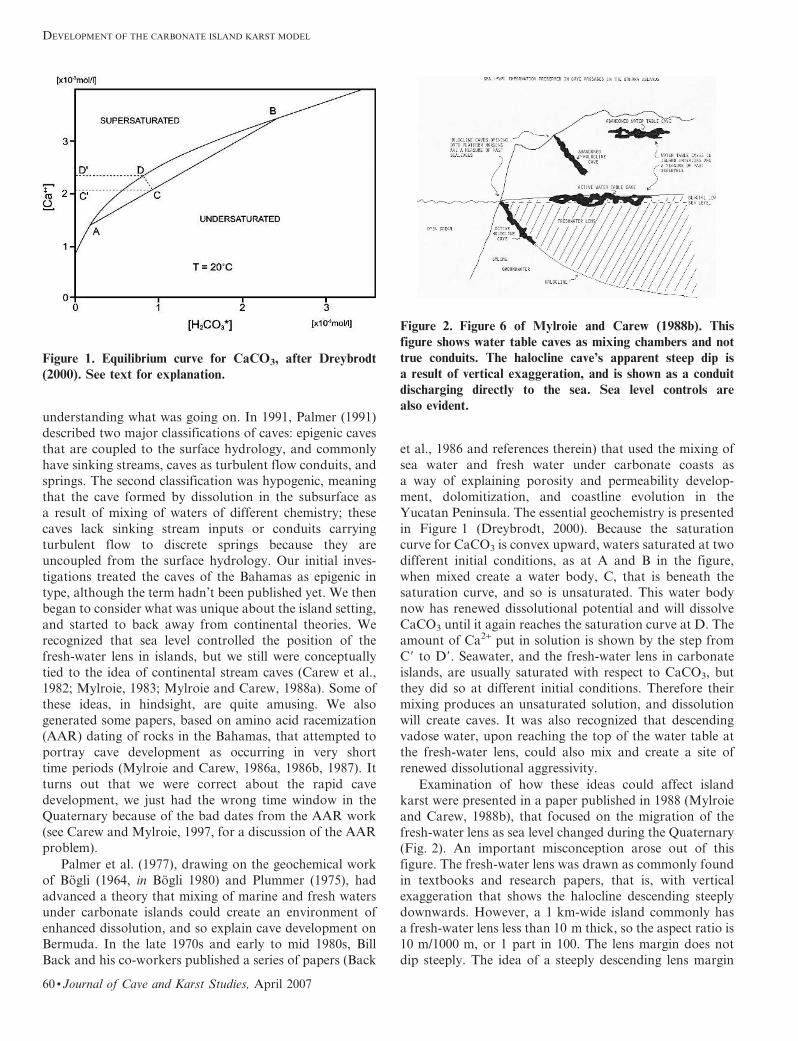
Yucatan Peninsula. The essential geochemistry is presented
in Figure 1 (Dreybrodt, 2000). Because the saturation
curve for CaCO3 is convex upward, waters saturated at two
different initial conditions, as at A and B in the figure,
when mixed create a water body, C, that is beneath the
saturation curve, and so is unsaturated. This water body
now has renewed dissolutional potential and will dissolve
CaCO3 until it again reaches the saturation curve at D. The
amount of Ca2+ put in solution is shown by the step from
C9 to D9. Seawater, and the fresh-water lens in carbonate
islands, are usually saturated with respect to CaCO3, but
they did so at different initial conditions. Therefore their
mixing produces an unsaturated solution, and dissolution
will create caves. It was also recognized that descending
vadose water, upon reaching the top of the water table at
the fresh-water lens, could also mix and create a site of
renewed dissolutional aggressivity.
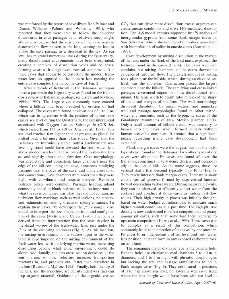
Examination of how these ideas could affect island
karst were presented in a paper published in 1988 (Mylroie
and Carew, 1988b), that focused on the migration of the
fresh-water lens as sea level changed during the Quaternary
(Fig. 2). An important misconception arose out of this
figure. The fresh-water lens was drawn as commonly found
in textbooks and research papers, that is, with vertical
exaggeration that shows the halocline descending steeply
downwards. However, a 1 km-wide island commonly has
a fresh-water lens less than 10 m thick, so the aspect ratio is
10 m/1000 m, or 1 part in 100. The lens margin does not
dip steeply. The idea of a steeply descending lens margin
Figure 1. Equilibrium curve for CaCO3, after Dreybrodt
(2000). See text for explanation.
Figure 2. Figure 6 of Mylroie and Carew (1988b). This
figure shows water table caves as mixing chambers and not
true conduits. The halocline cave’s apparent steep dip is
a result of vertical exaggeration, and is shown as a conduit
discharging directly to the sea. Sea level controls are
also evident.
DEVELOPMENT OF THE CARBONATE ISLAND KARST MODEL
60 N Journal of Cave and Karst Studies, April 2007
was reinforced by the report of cave divers Rob Palmer and
Dennis Williams (Palmer and Williams, 1984), who
reported that they were able to follow the halocline
downwards in cave passages at a relatively steep angle.
We now recognize that the existence of the cave passage
distorted the flow pattern in the lens, causing the lens to
utilize the cave passage as a short-cut to the sea. As sea
level has migrated numerous times during the Quaternary,
many dissolutional environments have been overprinted,
creating a complex of dissolution voids and collapses,
forming caves with a significant vertical component. It is
these caves that appear to be distorting the modern fresh-
water lens, as opposed to the modern lens creating the
entire cave complex (the halocline cave of Fig. 2).
After a decade of fieldwork in the Bahamas, we began
to see a pattern in the largest dry caves found on the islands
(for a review of Bahamian geology, see Carew and Mylroie,
1995a; 1997). The large caves commonly were entered
where a hillside had been breached by erosion or had
collapsed. The caves were found at elevations of 1 to 7 m,
which was in agreement with the position of at least one
earlier sea level during the Quaternary, the last interglacial
associated with Oxygen Isotope Substage 5e (OIS 5e),
which lasted from 131 to 119 ka (Chen et al., 1991). This
sea level reached 6 m higher than at present, as glacial ice
melted back a bit more than it has today. Given that the
Bahamas are tectonically stable, only a glacioeustatic sea-
level highstand could have elevated the fresh-water lens
above modern sea level, and so placed the fresh-water lens
at, and slightly above, that elevation. Cave morphology
was predictable and consistent: large chambers near the
edge of the hill containing the cave, numerous ramifying
passages near the back of the cave, and many cross-links
and connections. Cave chambers were wider than they were
high, with curvilinear and cuspate margins. Remnant
bedrock pillars were common. Passages heading inland
commonly ended in blank bedrock walls. As important as
what the caves contained was what they did not contain: no
turbulent flow markings such as wall scallops, no stream-
laid sediments, no sinking stream or spring entrances. To
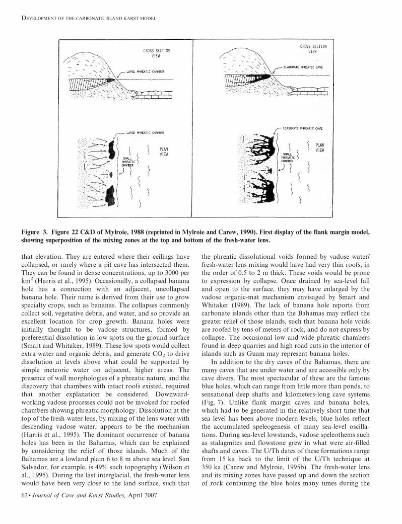
explain these caves, we developed the flank margin cave
model to interpret the size, shape, position and configura-
tion of the caves (Mylroie and Carew, 1990). The name is
derived from the interpretation that the caves develop in
the distal margin of the fresh-water lens, just under the
flank of the enclosing landmass (Fig. 3). At this location,
the mixing environment of the vadose input to the water
table is superimposed on the mixing environment of the
fresh-water lens with underlying marine water, increasing
dissolution beyond what either environment could do
alone. Additionally, the lens cross section decreases at the
lens margin, so flow velocities increase, transporting
reactants in, and products out, faster than elsewhere in
the lens (Raeisi and Mylroie, 1995). Finally, both the top of
the lens, and the halocline, are density interfaces that can
trap organic material. Oxidation of the organics creates
CO2 that can drive more dissolution; excess organics can
create anoxic conditions and drive H2S-mediated dissolu-
tion. The H2S model appears supported by 34S analysis of
intergranular gypsum from some flank margin caves on
San Salvador, which showed depletion values associated
with biomediation of sulfur in anoxic zones (Bottrell et al.,
1993).
Cave development by mixing dissolution in the margin
of the lens, under the flank of the land mass, explained the
features found in the caves (Fig. 4). The caves were not
conduits, but mixing chambers, so the caves showed no
evidence of turbulent flow. The greatest amount of mixing
took place near the hillside, which, during an elevated sea
level, was the shoreline. This action placed the largest
chambers near the hillside. The ramifying and cross-linked
passages represented migration of the dissolutional front
inland. The large width to height ratio mimicked the shape
of the distal margin of the lens. The wall morphology
displayed dissolution by mixed waters, and mimicked
wall and passage morphologies found in other mixed-
water environments, such as the hypogenic caves of the
Guadalupe Mountains of New Mexico (Palmer, 1991).
Only a small amount of hillside erosion was necessary to
breach into the caves, which formed initially without
human-accessible entrances. It seemed that a significant
puzzle regarding island cave development had been
explained.
Flank margin caves were the largest, but not the only,
type of cave found in the Bahamas. Two other types of dry
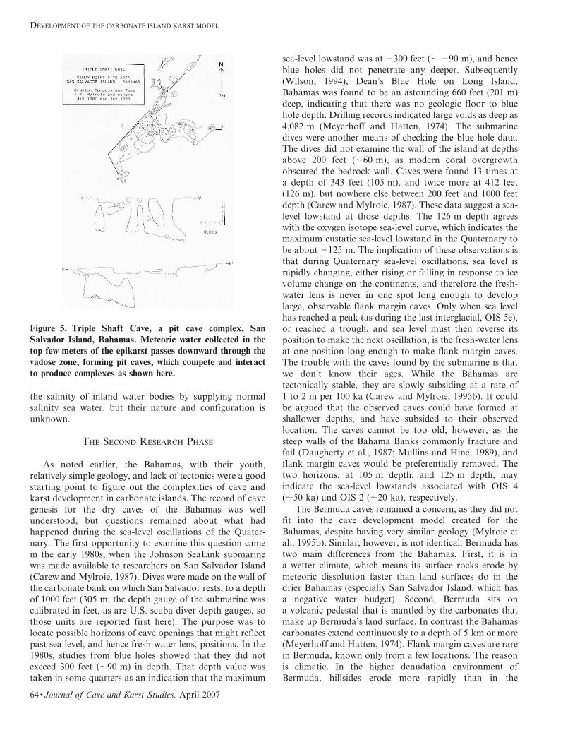
caves were abundant. Pit caves are found all over the
Bahamas, sometimes in very dense clusters, and occasion-
ally at the top of hills. As the name suggests, these are
vertical shafts that descend typically 5 to 10 m (Fig. 5).
They rarely intersect flank margin caves. Their walls show
classic vertical grooves formed by supercritical laminar
flow of descending vadose water. During major rain events,
they can be observed to efficiently collect water from the
epikarst and conduct it downwards as vadose fast-flow
routes. Their high density in places was initially thought,
based on water budget considerations, to indicate much
higher rainfall conditions at a past time. The high pit cave
density is now understood to reflect competition and piracy
among pit caves, such that some lose their recharge to
upstream competitors (Harris et al., 1995). These caves can
be complex as a result of this competition, which
commonly leads to intersection of pit caves by one another.
Pit caves form independently of sea level and fresh-water
lens position, and can form in any exposed carbonate rock
on an island.
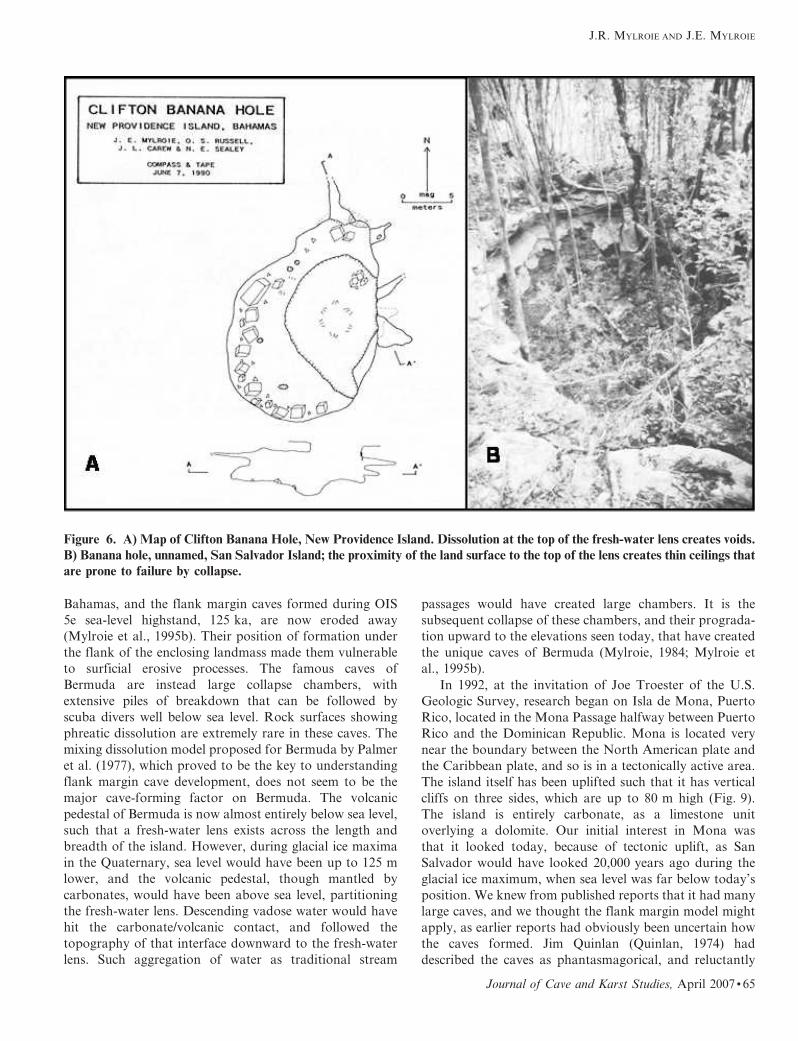
The remaining major dry cave type is the banana hole.
Banana holes are circular to oval chambers 5 to 10 m in
diameter, and 1 to 3 m high, with phreatic morphologies
but lacking the size and passage ramifications found in
flank margin caves (Fig. 6). They are located in positions
of 0 to 7 m above sea level, but laterally well away from
where the lens margin would have been with sea level at
J.R. MYLROIE AND J.E. MYLROIE
Journal of Cave and Karst Studies, April 2007 N 61
that elevation. They are entered where their ceilings have
collapsed, or rarely where a pit cave has intersected them.
They can be found in dense concentrations, up to 3000 per
km2 (Harris et al., 1995). Occasionally, a collapsed banana
hole has a connection with an adjacent, uncollapsed
banana hole. Their name is derived from their use to grow
specialty crops, such as bananas. The collapses commonly
collect soil, vegetative debris, and water, and so provide an
excellent location for crop growth. Banana holes were
initially thought to be vadose structures, formed by
preferential dissolution in low spots on the ground surface
(Smart and Whitaker, 1989). These low spots would collect
extra water and organic debris, and generate CO2 to drive
dissolution at levels above what could be supported by
simple meteoric water on adjacent, higher areas. The
presence of wall morphologies of a phreatic nature, and the
discovery that chambers with intact roofs existed, required
that another explanation be considered. Downward-
working vadose processes could not be invoked for roofed
chambers showing phreatic morphology. Dissolution at the
top of the fresh-water lens, by mixing of the lens water with
descending vadose water, appears to be the mechanism
(Harris et al., 1995). The dominant occurrence of banana
holes has been in the Bahamas, which can be explained
by considering the relief of those islands. Much of the
Bahamas are a lowland plain 6 to 8 m above sea level. San
Salvador, for example, is 49% such topography (Wilson et
al., 1995). During the last interglacial, the fresh-water lens
would have been very close to the land surface, such that
the phreatic dissolutional voids formed by vadose water/
fresh-water lens mixing would have had very thin roofs, in
the order of 0.5 to 2 m thick. These voids would be prone
to expression by collapse. Once drained by sea-level fall
and open to the surface, they may have enlarged by the
vadose organic-mat mechanism envisaged by Smart and
Whitaker (1989). The lack of banana hole reports from
carbonate islands other than the Bahamas may reflect the
greater relief of those islands, such that banana hole voids
are roofed by tens of meters of rock, and do not express by
collapse. The occasional low and wide phreatic chambers
found in deep quarries and high road cuts in the interior of
islands such as Guam may represent banana holes.
In addition to the dry caves of the Bahamas, there are
many caves that are under water and are accessible only by
cave divers. The most spectacular of these are the famous
blue holes, which can range from little more than ponds, to
sensational deep shafts and kilometers-long cave systems
(Fig. 7). Unlike flank margin caves and banana holes,
which had to be generated in the relatively short time that
sea level has been above modern levels, blue holes reflect
the accumulated speleogenesis of many sea-level oscilla-
tions. During sea-level lowstands, vadose speleothems such
as stalagmites and flowstone grew in what were air-filled
shafts and caves. The U/Th dates of these formations range
from 15 ka back to the limit of the U/Th technique at
350 ka (Carew and Mylroie, 1995b). The fresh-water lens
and its mixing zones have passed up and down the section
of rock containing the blue holes many times during the
Figure 3. Figure 22 C&D of Mylroie, 1988 (reprinted in Mylroie and Carew, 1990). First display of the flank margin model,
showing superposition of the mixing zones at the top and bottom of the fresh-water lens.
DEVELOPMENT OF THE CARBONATE ISLAND KARST MODEL
62 N Journal of Cave and Karst Studies, April 2007

Quaternary. The amount of over-printing by fresh-, mixed-
and salt-water environments, vadose conditions, and
collapse is immense. Because of the extensive use of blue
holes by recreational divers, in the late 1980s there was
confusion about what a blue hole was and how they should
be defined. After consulting with Bahamian blue hole
explorer Rob Palmer, cave scientist Pete Smart, and
Bahamas geographer Neil Sealey, the following definition
for blue holes was proposed (Mylroie et al., 1995a, p. 225):
‘‘subsurface voids that are developed in carbonate banks
and islands; are open to the earth’s surface; contain tidally-
influenced waters of fresh, marine, or mixed chemistry;
extend below sea level for a majority of their depth; and
may provide access to submerged cave passages.’’ As blue
holes can be found in island interiors, or in lagoons,
a further description was added: ‘‘ocean holes open directly
into the present marine environment and contain marine
water, usually with tidal flow; inland blue holes are isolated
by present topography from marine conditions, and open
directly onto the land surface or into an isolated pond or
lake, and contain tidally-influenced water of a variety of
chemistries from fresh to marine’’ (Mylroie et al., 1995a, p.
225). A different approach to defining and describing blue
holes can be found in Schwabe and Carew (2006). Blue
holes are polygenetic, forming by drowning of pit caves,
flank margin caves and banana holes; by progradational
collapse; by bank margin failure; and by marine flooding of
paleoconduits (Fig. 8). Blue holes are known to react to
tides, sometimes with strong currents, especially for ocean
holes. Smaller holes, found on inland water bodies in the
Bahamas, have been called lake drains (Mylroie et al.,
1995b). These are very cryptic features that help regulate
Figure 4. Salt Pond Cave, Long Island, Bahamas. A) Map of the cave, showing passage shape and configuration. B) Interior
of Salt Pond Cave, showing a long, tubular passage ending in a blank bedrock wall; the site of the dissolution front when sea
level fell at the end of the last interglacial sea-level highstand. C) Interior of Salt Pond Cave, demonstrating the great width
relative to height in flank margin caves, indicative of their formation in the thin distal margin of the fresh-water lens.
J.R. MYLROIE AND J.E. MYLROIE
Journal of Cave and Karst Studies, April 2007 N 63
the salinity of inland water bodies by supplying normal
salinity sea water, but their nature and configuration is
unknown.
THE SECOND RESEARCH PHASE
As noted earlier, the Bahamas, with their youth,
relatively simple geology, and lack of tectonics were a good
starting point to figure out the complexities of cave and
karst development in carbonate islands. The record of cave
genesis for the dry caves of the Bahamas was well
understood, but questions remained about what had
happened during the sea-level oscillations of the Quater-
nary. The first opportunity to examine this question camein the early 1980s, when the Johnson SeaLink submarine
was made available to researchers on San Salvador Island
(Carew and Mylroie, 1987). Dives were made on the wall of
the carbonate bank on which San Salvador rests, to a depth
of 1000 feet (305 m; the depth gauge of the submarine was
calibrated in feet, as are U.S. scuba diver depth gauges, so
those units are reported first here). The purpose was to
locate possible horizons of cave openings that might reflectpast sea level, and hence fresh-water lens, positions. In the
1980s, studies from blue holes showed that they did not
exceed 300 feet (,90 m) in depth. That depth value was
taken in some quarters as an indication that the maximum
sea-level lowstand was at 2300 feet (, 290 m), and hence
blue holes did not penetrate any deeper. Subsequently
(Wilson, 1994), Dean’s Blue Hole on Long Island,
Bahamas was found to be an astounding 660 feet (201 m)
deep, indicating that there was no geologic floor to blue
hole depth. Drilling records indicated large voids as deep as
4,082 m (Meyerhoff and Hatten, 1974). The submarine
dives were another means of checking the blue hole data.
The dives did not examine the wall of the island at depths
above 200 feet (,60 m), as modern coral overgrowth
obscured the bedrock wall. Caves were found 13 times at
a depth of 343 feet (105 m), and twice more at 412 feet
(126 m), but nowhere else between 200 feet and 1000 feet
depth (Carew and Mylroie, 1987). These data suggest a sea-
level lowstand at those depths. The 126 m depth agrees
with the oxygen isotope sea-level curve, which indicates the
maximum eustatic sea-level lowstand in the Quaternary to
be about 2125 m. The implication of these observations is
that during Quaternary sea-level oscillations, sea level is
rapidly changing, either rising or falling in response to ice
volume change on the continents, and therefore the fresh-
water lens is never in one spot long enough to develop
large, observable flank margin caves. Only when sea level
has reached a peak (as during the last interglacial, OIS 5e),
or reached a trough, and sea level must then reverse its
position to make the next oscillation, is the fresh-water lens
at one position long enough to make flank margin caves.
The trouble with the caves found by the submarine is that
we don’t know their ages. While the Bahamas are
tectonically stable, they are slowly subsiding at a rate of
1 to 2 m per 100 ka (Carew and Mylroie, 1995b). It could
be argued that the observed caves could have formed at
shallower depths, and have subsided to their observed
location. The caves cannot be too old, however, as the
steep walls of the Bahama Banks commonly fracture and
fail (Daugherty et al., 1987; Mullins and Hine, 1989), and
flank margin caves would be preferentially removed. The
two horizons, at 105 m depth, and 125 m depth, may
indicate the sea-level lowstands associated with OIS 4
(,50 ka) and OIS 2 (,20 ka), respectively.
The Bermuda caves remained a concern, as they did not
fit into the cave development model created for the
Bahamas, despite having very similar geology (Mylroie et
al., 1995b). Similar, however, is not identical. Bermuda has
two main differences from the Bahamas. First, it is in
a wetter climate, which means its surface rocks erode by
meteoric dissolution faster than land surfaces do in the
drier Bahamas (especially San Salvador Island, which has
a negative water budget). Second, Bermuda sits on
a volcanic pedestal that is mantled by the carbonates that
make up Bermuda’s land surface. In contrast the Bahamas
carbonates extend continuously to a depth of 5 km or more
(Meyerhoff and Hatten, 1974). Flank margin caves are rare
in Bermuda, known only from a few locations. The reason
is climatic. In the higher denudation environment of
Bermuda, hillsides erode more rapidly than in the
Figure 5. Triple Shaft Cave, a pit cave complex, San
Salvador Island, Bahamas. Meteoric water collected in the
top few meters of the epikarst passes downward through the
vadose zone, forming pit caves, which compete and interactto produce complexes as shown here.
DEVELOPMENT OF THE CARBONATE ISLAND KARST MODEL
64 N Journal of Cave and Karst Studies, April 2007
Bahamas, and the flank margin caves formed during OIS
5e sea-level highstand, 125 ka, are now eroded away
(Mylroie et al., 1995b). Their position of formation under
the flank of the enclosing landmass made them vulnerable
to surficial erosive processes. The famous caves of
Bermuda are instead large collapse chambers, with
extensive piles of breakdown that can be followed by
scuba divers well below sea level. Rock surfaces showing
phreatic dissolution are extremely rare in these caves. The
mixing dissolution model proposed for Bermuda by Palmer
et al. (1977), which proved to be the key to understanding
flank margin cave development, does not seem to be the
major cave-forming factor on Bermuda. The volcanic
pedestal of Bermuda is now almost entirely below sea level,
such that a fresh-water lens exists across the length and
breadth of the island. However, during glacial ice maxima
in the Quaternary, sea level would have been up to 125 m
lower, and the volcanic pedestal, though mantled by
carbonates, would have been above sea level, partitioning
the fresh-water lens. Descending vadose water would have
hit the carbonate/volcanic contact, and followed the
topography of that interface downward to the fresh-water
lens. Such aggregation of water as traditional stream
passages would have created large chambers. It is the
subsequent collapse of these chambers, and their prograda-
tion upward to the elevations seen today, that have created
the unique caves of Bermuda (Mylroie, 1984; Mylroie et
al., 1995b).
In 1992, at the invitation of Joe Troester of the U.S.
Geologic Survey, research began on Isla de Mona, Puerto
Rico, located in the Mona Passage halfway between Puerto
Rico and the Dominican Republic. Mona is located very
near the boundary between the North American plate and
the Caribbean plate, and so is in a tectonically active area.
The island itself has been uplifted such that it has vertical
cliffs on three sides, which are up to 80 m high (Fig. 9).
The island is entirely carbonate, as a limestone unit
overlying a dolomite. Our initial interest in Mona was
that it looked today, because of tectonic uplift, as San
Salvador would have looked 20,000 years ago during the
glacial ice maximum, when sea level was far below today’s
position. We knew from published reports that it had many
large caves, and we thought the flank margin model might
apply, as earlier reports had obviously been uncertain how
the caves formed. Jim Quinlan (Quinlan, 1974) had
described the caves as phantasmagorical, and reluctantly
Figure 6. A) Map of Clifton Banana Hole, New Providence Island. Dissolution at the top of the fresh-water lens creates voids.
B) Banana hole, unnamed, San Salvador Island; the proximity of the land surface to the top of the lens creates thin ceilings that
are prone to failure by collapse.
J.R. MYLROIE AND J.E. MYLROIE
Journal of Cave and Karst Studies, April 2007 N 65
placed them in the sea cave category, as he recognized that
the caves were not traditional turbulent-flow conduits.
Upon field examination, we determined the caves were
clearly flank margin caves (Frank et al., 1998), but at an
immense scale. The Lirio Cave System eventually mapped
out at 20 km, and wrapped around the curving edge of the
island (Fig. 10). The question then became why were the
caves so large? Caves of over 1 km of linear survey are
known in the Bahamas, but 20 km was astounding. The
answer lay in the age of the caves. Working with Bruce
Panuska, from our Geosciences Department (Panuska et
al., 1998), we established, based on paleomagnetic reversal
patterns in cave sediments and speleothems, that the caves
were at least 1.8 million years old. The caves had developed
in the Pliocene, before the onset of the high amplitude,
short wavelength sea-level oscillations that characterize the
Quaternary. Therefore sea level, and fresh-water lens
position, had been stable at a given horizon for a much
longer time than had been available in the younger rocks of
the Bahamas. This longer time of lens stability had allowed
extremely large flank margin caves to develop. Uplift then
had placed the caves far above the influence of Quaternary
sea-level change, effectively preserving the caves. The
Bahamas demonstrated that significant flank margin caves
could form in short time windows of approximately
10,000 years. Mona showed that once formed, such caves
could survive for more than a million years. Flank margin
caves are high-resolution, long-duration repositories of
speleological information.
The work in Bermuda and the Bahamas was summa-
rized in Mylroie et al. (1995b) and the Isla de Mona work
was summarized in Mylroie & Carew (1995) and in Frank
et al. (1998). One of the results of this early work was the
recognition that closed contour depressions (commonly
labeled in karst areas as sinkholes, uvalas, poljes, etc.) in
these young islands were primarily constructional. That is,
the depressions were the result of differential deposition of
the carbonate rock to create closed contour depressions
that drained by karst processes and therefore avoided
becoming lakes and ponds. In the Bahamas, the swales
between large carbonate eolian dunes had the appearance
of very large closed depressions covering thousands of
square meters. In other cases, the closed depression was
a former lagoon, developed during the 6 m sea-level
highstand of the last interglacial (OIS 5e), and now drained
because sea level is not as high as it was at 125 ka. Most
sinkholes in the 1 to 10 m diameter range found in the
Bahamas are cave collapses, the majority a result of banana
hole formation that was discussed earlier. The Bahamas
differ from continental karst not only in the caves, but also
in the depressions. Whereas most depressions, large and
small, in continents are the result of dissolutional processes
acting from the surface downward, in the Bahamas the
large depressions are constructional and the small ones are
collapse features from dissolution acting at a variety of
depths, in a hypogenic mode.
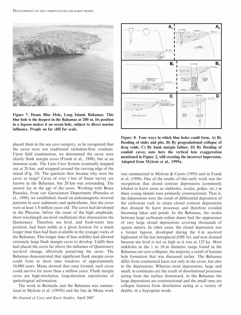
Figure 7. Deans Blue Hole, Long Island, Bahamas. This
blue hole is the deepest in the Bahamas at 200 m. Its position
in a lagoon makes it an ocean hole, subject to direct marine
influence. People on far cliff for scale.
Figure 8. Four ways in which blue holes could form. A) By
flooding of sinks and pits. B) By progradational collapse of
deep voids. C) By bank margin failure. D) By flooding ofconduit caves; note here the vertical lens exaggeration
mentioned in Figure 2, still creating the incorrect impression.
Adapted from Mylroie et al., 1995a.
DEVELOPMENT OF THE CARBONATE ISLAND KARST MODEL
66 N Journal of Cave and Karst Studies, April 2007

THE CURRENT RESEARCH PHASE
In 1997, John Mylroie was asked to present a keynote
address on ‘‘Land Use and Carbonate Island Karst’’ at the
Sixth Multidisciplinary Conference on Sinkholes and the
Engineering and Environmental Impacts of Karst held inSpringfield, Missouri in April of that year. The paper
published from that conference (Mylroie and Carew, 1997)
made the first attempt to view karst development on
carbonate islands as a result of a predictable hierarchy
(Fig. 11). The differences between some types of island
cave and karst development could be attributed to
interactions (or the lack thereof) of carbonate rocks with
non-carbonate rocks that are commonly found on manyislands. The announced presentation on carbonate island
karst induced John Jenson, of the Water and Energy
Resource Institute of the Western Pacific (now the Water
and Environmental Research Institute, or WERI) at the
University of Guam, to attend the conference to talk about
his karst land use problems in Guam. From that meeting
began a fruitful collaboration to investigate the tectonically
active, geologically complex carbonate islands of theMariana Archipelago.
Work in the Mariana Islands began on Guam in July
of 1998. As with Isla de Mona, the carbonate rocks in
the Marianas, while Cenozoic, were older than those of
the Bahamas, and tectonic uplift played an important
role. Unlike Isla de Mona, however, non-carbonate
rocks outcropped on the surface. These outcrops created
allogenic recharge, which upon reaching the contact with
carbonate rocks, formed sinking streams, stream caves, andcave springs; typical epigenic caves. Guam provided field
proof of the predicted third island category from Fig. 11C.
In the vicinity of non-carbonate outcrops, allogenic water
created caves similar to what can be found on continents.
In the carbonate outcrop at a distance from those non-
carbonate rocks, autogenic recharge controlled karst
development. And in the carbonate coastal areas, classic
flank margin cave development dominated. Isla de Mona,
while tectonically uplifted, did not show any evidence of
uplift in the last 125 ka (Frank et al., 1998). Guam and theother Mariana islands showed evidence of uplift through-
out the Quaternary and up to the present day (Dickenson,
1999). The Mariana Islands presented an island karst
environment of much greater complexity than had pre-
viously been studied. The field work, done in collaboration
with John Jenson and his students, resulted in the first
comprehensive interpretation of cave and karst develop-
ment on Guam (Mylroie et al., 2001). The M.Sc. thesisfrom the Guam work by Danko Taborosi (Taborosi, 2000)
instigated a series of publications addressing karren
formation (Taborosi et al., 2004), cave development and
distribution (Taborosi et al., 2005), and speleothem
formation (Taborosi, 2006) as part of a Ph.D. program
at Hokkaido University. The Marianas work continued on
to Saipan (Wexel et al., 2001), Aquijan (Stafford et al.,
2004), Tinian (Stafford et al., 2005), and Rota (Keel et al.,2006) islands, culminating in a review article of the caves
and karst of the Marianas Archipelago (Jenson et al.,
2006). The Saipan work (Jenson et al., 2002) resulted in
a modification of the island category hierarchy to include
a fourth category, the complex island, to represent
situations in which complex faulting, and syndeposition
of carbonates and volcaniclastics resulted in very complex
compartmentalization of the fresh-water lens. One of theunusual outcomes of such compartmentalization is pro-
tection of water resources from upconing and saltwater
intrusion during aquifer pumping. Another unexpected
Figure 9. Uplifted north side of Isla de Mona, Puerto Rico. Cliff is 70 m high, with flank margin caves visible at the top, along
the limestone/dolomite contact.
J.R. MYLROIE AND J.E. MYLROIE
Journal of Cave and Karst Studies, April 2007 N 67

outcome was the development of confined aquifers,
creating phreatic lift tubes to carry water out of the aquifer
compartment, as in Kalabera Cave, Saipan (Jenson et al.,
2006).
The island categories (Fig. 11) established in Mylroie
and Carew (1997), were modified in Mylroie et al. (2001) to
reflect advice from H. Len Vacher at the University of
South Florida (Mylroie and Vacher, 1999) that not all
carbonate islands showing non-carbonate outcrops had the
carbonate rocks as a rim, so the third category was
modified from carbonate-rimmed island to composite
island. That action, and the addition of the complex island
category resulted in the creation of a new, four panel figure
to express the island type hierarchy (Fig. 12).
Understanding of water flow dynamics in carbonate
islands had been pioneered by H. Len Vacher (e.g., Vacher,
1988). The key to that work was the recognition that
carbonate aquifers are unique in hydrology in that they are
capable of extensive self-modification through dissolu-
tional and depositional processes involving CaCO3. This
self-modification is extremely important in the young
carbonate rocks that make up carbonate islands today.
One of the unexpected outcomes of this work was that the
longer a fresh-water lens sat in a given section of young
carbonate rock, the more permeable the rock became. As
shown in Figure 2, the fresh-water lens exists because
a slope, or head, of water is needed to drive the meteoric
water collected at the water table to the island perimeter.
The less permeable the rock, the steeper the necessary slope
(as an analogy, consider a car on a slope; if the axles are
rusted, it takes a steep slope to move the car; if the axles are
greased, the car moves on a gentler slope). As the fresh-
water lens floats in a 1 to 40 ratio based on its density
difference with sea water (1.000 versus 1.025 g cm23), the
lens is 40 times as thick below sea level as it is above sea
level as a result of buoyancy. Therefore, as the lens
becomes more permeable by dissolution, its slope becomes
less, its elevation above sea level becomes less, so its
thickness becomes less. In the Bahamas, the thickest fresh
water lenses are found in the recent Holocene sands (Wallis
et al., 1991). While these sands have very high primary
porosity, that porosity is not organized into high perme-
ability, and the lens is relatively thick as water flow is not
efficient. In the adjacent, older Pleistocene rocks, which
may have seen two or more sea-level highstands and
associated fresh-water lens events, the permeability is
higher and the lens is thinner. Building on these studies,
Vacher and Mylroie (2002, p. 183) defined the term
eogenetic karst as ‘‘the land surface evolving on, and the
pore system developing in, rocks undergoing eogenetic,
meteoric diagenesis.’’ The term eogenetic was derived from
Choquette and Pray’s (1970, p. 215) studies of rock age and
diagenesis; they defined ‘‘the time of early burial as
eogenetic, the time of deeper burial as mesogenetic, and
the late stage of associated with erosion of long-buried
carbonates as telogenetic.’’ Most karst in continental
settings is the result of dissolutional processes acting on
telogenetic rocks, rocks that are diagenetically mature,
recystallized, and lack significant primary porosity. In
eogenetic karst, caves are created directly within the
eogenetic rocks, bypassing diagenetic maturation, uplift,
and telogenetic dissolution (Fig. 13).
The parameters that controlled the development of karst
on islands were initially outlined by Mylroie and Vacher
(1999) and codified as the Carbonate Island Karst Model, or
CIKM, which first appeared by that name after the initial
study of Guam (Mylroie and Jenson, 2000; Mylroie et al.,
2001). The CIKM has been tweaked and modified over the
years. The principles of the CIKM include:
1. Mixing of fresh and salt water at the boundaries of the
fresh water lens results in a localized area of
preferential porosity and permeability development.
Collection of organics at these boundaries may also
Figure 10. Map of the Lirio Cave Complex, Isla de Mona,
Puerto Rico. Note that the cave is maze-like, with largerchambers towards the coast; that the cave does not penetrate
very far inland but does wrap around the island coastline.
DEVELOPMENT OF THE CARBONATE ISLAND KARST MODEL
68 N Journal of Cave and Karst Studies, April 2007

enhance dissolution. The maximum dissolution occurs
at the lens margin, where the water table and haloclinemixing zones are superimposed.
2. Glacioeustacy has moved sea level, and thus the freshwater lens position, up and down more than 100 m
throughout the Quaternary.
3. Local tectonic movement can cause overprinting of
dissolutional and diagenetic features developed during
different glacioeustatic events.
4. The karst is eogenetic in that it has developed on rocks
that are young and have never been buried below the
zone of meteoric diagenesis.
5. Carbonate islands can be divided into four categories
based on basement/sea level relationships (Figs. 11
and 12).
A. Simple Carbonate Island—Only carbonate rocks
are present (Fig. 11A). Meteoric catchment is
Figure 11. First presentation of a karst classification of carbonate islands, from Mylroie and Carew (1997). The Bahamas fit
the (A) Category, Bermuda (at sea-level lowstands) fits the (B) Category, and Guam fits the (C) Category.
J.R. MYLROIE AND J.E. MYLROIE
Journal of Cave and Karst Studies, April 2007 N 69

entirely autogenic and flow within the fresh water
lens is controlled entirely by properties of the
carbonate rock. The Bahamas are examples of
simple carbonate islands.
B. Carbonate-Cover Island—Only carbonate rocks
are exposed at the surface and the catchment is
entirely autogenic (Fig. 11B). Non-carbonate
rocks exist under carbonate rocks and may
partition and influence flow within the lens,
including conduit flow at the contact. Bermuda,
at a sea-level lowstand, is an example of a carbon-
ate-cover island.
C. Composite Island—Both carbonate and non-
carbonate rocks are exposed at the surface
(Fig. 12), allowing for allogenic and autogenic
catchment. The lens is partitioned and conduit
cave systems can develop at the contact of the
carbonate and non-carbonate rocks. Barbados
and Guam are examples of composite islands.
D. Complex Island—Carbonate and non-carbonate
rocks are complexly interrelated by depositional
relationships and/or faulting (Fig. 12). Perching,
isolation, and confining of the fresh-water lens is
possible. Saipan is an example.
Vacher and Mylroie (2002) also differentiated between
island karst, and karst on islands. Island karst develops
under the influence of the CIKM. Karst on islands
develops in uplifted regions of island interiors, and behaves
much the same way as karst on continents at the same
latitude. The flank margin caves of Isla de Mona or the
Bahamas are examples of island karst. The cockpits of
Jamaica, or the mogotes of Puerto Rico, are examples of
karst on islands, as they are isolated from glacioeustasy
and fresh water/salt water mixing. They are similar to the
karst landforms of Belize, a tropical but continental
setting.
The karren (dissolutional sculpture at the centimeter to
meter scale) of carbonate islands differ from those found in
continental interiors of the mid to high latitudes, where
most karren research has been done. The jagged, pitted and
irregular karren of the coastal environment of tropical
carbonate islands is well known, and the classic study is by
Folk et al. (1973). That work, and many later works (e.g.,
Viles, 1988) ascribed the unique nature of this island karren
to marine spray, boring endolithic algae, and grazing by
gastropods, among other reasons. Folk et al. (1973) called
it phytokarst, based on the large degree to which the
endolithic algae had penetrated and permeated the rock
surface. Taborosi et al. (2004) were able to demonstrate
that the key factor was the eogenetic nature of the rock.
The lack of diagenetic maturity made all weathering
processes, organic and inorganic, responsive to the texture,
composition, porosity, and cementation of the allochems
(particles) that made up the young carbonates. Taborosi et
al. (2004) called such karst etching eogenetic karren.
Endolithic algae were able to colonize such weak and
porous rock in high abundance, which initiated the entire
organic aspect of karren development in the coastal
carbonates of tropical islands. Endolithic algae do not
colonize dense, recrystallized teleogenetic rocks to a similar
extent. On southern Guam, in the interior away from
CIKM effects, are limestone units ranging in age from
Figure 12. Updated karst classification of carbonate is-
lands, changing Figure 11C from carbonate-rimmed island to
composite island, and adding a new category, the complex
island, best represented by Saipan.
Figure 13. The evolution of eogenetic karst. Slanting solidlines are hydraulic conductivity, K, in m/day. Slanted dashed
lines are tube density (number of tubes per unit area, or N/A),
a measure of the degree of enlargement of the pore structure
(with a consequent decrease in pore number). Eogenetic karst
takes a short cut from the original depositional environment
to cave development without going through burial, massive
diagenesis, and uplift. After Vacher and Mylroie, 2002.
DEVELOPMENT OF THE CARBONATE ISLAND KARST MODEL
70 N Journal of Cave and Karst Studies, April 2007
Oligocene to Pliocene. Analysis of these rocks and their
karren showed that as diagenetic maturity increased, the
karren became less distinctive as eogenetic karren, and
resembled more closely the telogenetic karren of continen-
tal interiors (Taborosi et al., 2004).
FUTURE RESEARCH
The current state of affairs regarding island karst is very
promising. One of the interesting applied research areas is
the potential for island karst to be preserved as paleokarst
in the rock record, therefore becoming a host formineralization or hydrocarbons. As eogenetic carbonate
rocks are found proximal to their environment of de-
position, all that needs to happen to preserve those rocks,
and any included karst features, is for subsidence to lower
them and continued carbonate deposition to bury them. To
preserve an existing telogenetic conduit cave system in
a continental interior setting would require major adjust-
ment of plate tectonic motion, to depress the landmass and
allow burial to occur. While all this plate adjustment was
occurring over millions of years, the existing cave system
would need to avoid destruction by erosion. It is clear that
eogenetic karst is predisposed to preservation, and that
paleokarst in the rock record is most likely former
eogenetic karst.
To locate and assess paleokarst in the subsurface, it is
important to determine what to search for. Imagine a large
carbonate unit in the subsurface, a disk 100 m thick and10 km in diameter, once exposed at the earth’s surface and
subjected to karst processes, and now buried. If one
assumes telogenetic, conduit cave karst, then one looks for
voids extending from the center of the disk to the margin in
a few places, as conduit caves that drained the interior of
the feature. If one assumes that eogenetic mixing zone karst
was active, then one looks for dissolutional voids spaced
around the perimeter of the feature. There is a 90udifference in search strategy depending on which model is
chosen.
The unique pattern of flank margin caves has called
attention to how they develop. Unlike teleogenetic conduit
caves, for which a large and extensive data base exists, the
eogenetic island cave data base has been built from scratch
over the last three decades by a very small group of
workers. As a result, until recently the patterns that drive
eogenetic caves such as flank margin caves were not easily
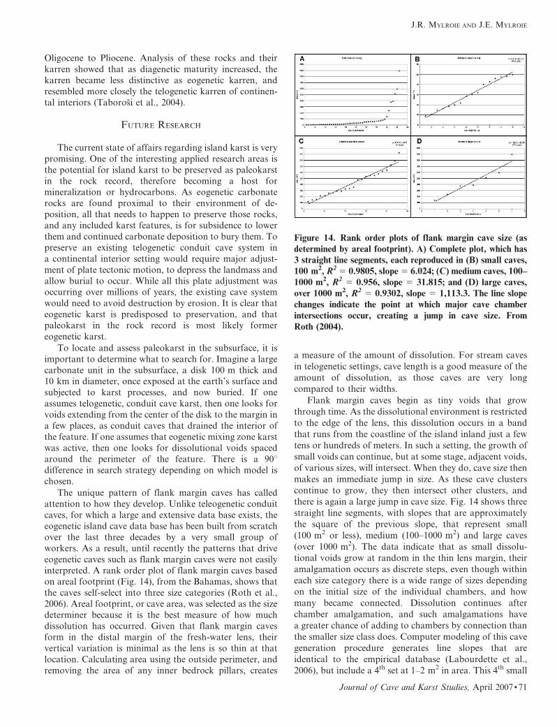
interpreted. A rank order plot of flank margin caves basedon areal footprint (Fig. 14), from the Bahamas, shows that
the caves self-select into three size categories (Roth et al.,
2006). Areal footprint, or cave area, was selected as the size
determiner because it is the best measure of how much
dissolution has occurred. Given that flank margin caves
form in the distal margin of the fresh-water lens, their
vertical variation is minimal as the lens is so thin at that
location. Calculating area using the outside perimeter, and
removing the area of any inner bedrock pillars, creates
a measure of the amount of dissolution. For stream caves
in telogenetic settings, cave length is a good measure of the
amount of dissolution, as those caves are very long
compared to their widths.
Flank margin caves begin as tiny voids that grow
through time. As the dissolutional environment is restricted
to the edge of the lens, this dissolution occurs in a band
that runs from the coastline of the island inland just a few
tens or hundreds of meters. In such a setting, the growth of
small voids can continue, but at some stage, adjacent voids,
of various sizes, will intersect. When they do, cave size then
makes an immediate jump in size. As these cave clusters
continue to grow, they then intersect other clusters, and
there is again a large jump in cave size. Fig. 14 shows three
straight line segments, with slopes that are approximately
the square of the previous slope, that represent small
(100 m2 or less), medium (100–1000 m2) and large caves
(over 1000 m2). The data indicate that as small dissolu-
tional voids grow at random in the thin lens margin, their
amalgamation occurs as discrete steps, even though within
each size category there is a wide range of sizes depending
on the initial size of the individual chambers, and how
many became connected. Dissolution continues after
chamber amalgamation, and such amalgamations have
a greater chance of adding to chambers by connection than
the smaller size class does. Computer modeling of this cave
generation procedure generates line slopes that are
identical to the empirical database (Labourdette et al.,
2006), but include a 4th set at 1–2 m2 in area. This 4th small
Figure 14. Rank order plots of flank margin cave size (as
determined by areal footprint). A) Complete plot, which has3 straight line segments, each reproduced in (B) small caves,
100 m2, R2 5 0.9805, slope 5 6.024; (C) medium caves, 100–
1000 m2, R2 5 0.956, slope 5 31.815; and (D) large caves,
over 1000 m2, R2 5 0.9302, slope 5 1,113.3. The line slope
changes indicate the point at which major cave chamber
intersections occur, creating a jump in cave size. From
Roth (2004).
J.R. MYLROIE AND J.E. MYLROIE
Journal of Cave and Karst Studies, April 2007 N 71
area group does not appear in the island data base as voids
that small are not mapped as caves.
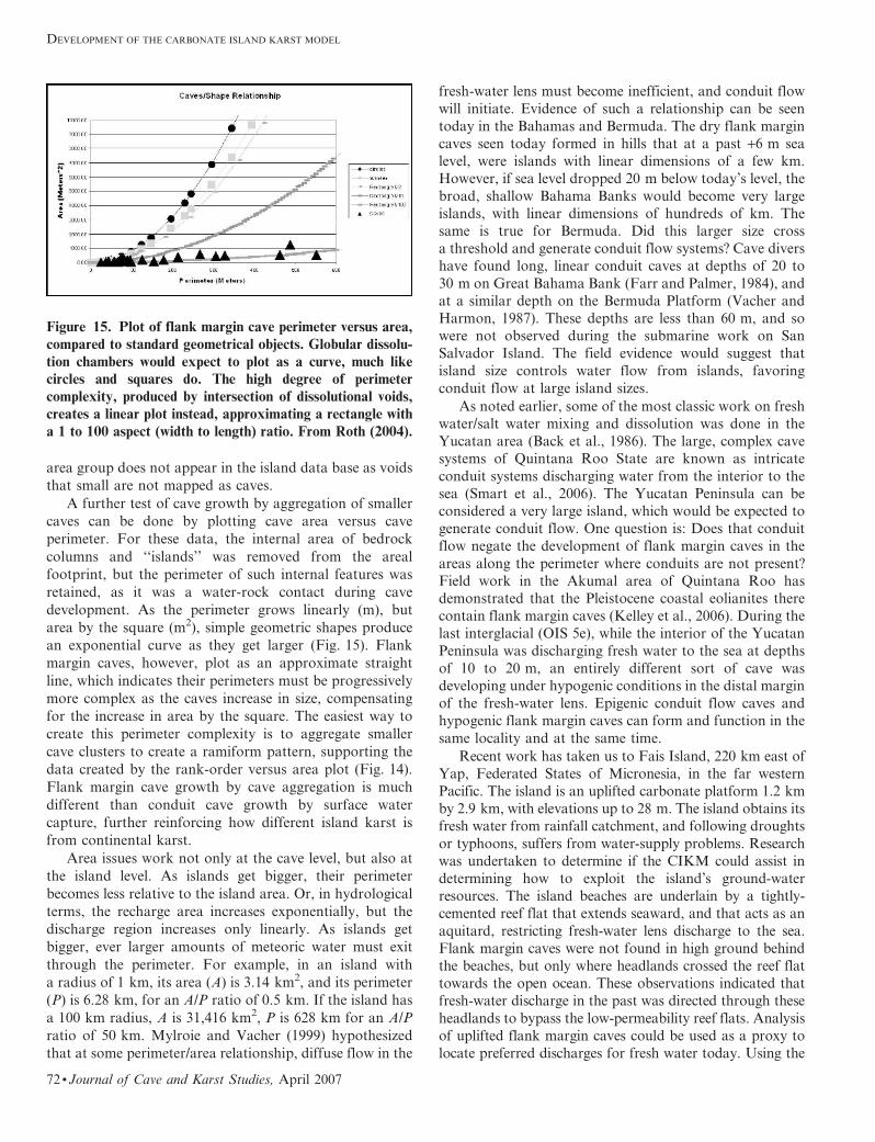
A further test of cave growth by aggregation of smaller
caves can be done by plotting cave area versus cave
perimeter. For these data, the internal area of bedrock
columns and ‘‘islands’’ was removed from the areal
footprint, but the perimeter of such internal features was
retained, as it was a water-rock contact during cave
development. As the perimeter grows linearly (m), but
area by the square (m2), simple geometric shapes produce
an exponential curve as they get larger (Fig. 15). Flank
margin caves, however, plot as an approximate straight
line, which indicates their perimeters must be progressively
more complex as the caves increase in size, compensating
for the increase in area by the square. The easiest way to
create this perimeter complexity is to aggregate smaller
cave clusters to create a ramiform pattern, supporting the
data created by the rank-order versus area plot (Fig. 14).
Flank margin cave growth by cave aggregation is much
different than conduit cave growth by surface water
capture, further reinforcing how different island karst is
from continental karst.
Area issues work not only at the cave level, but also at
the island level. As islands get bigger, their perimeter
becomes less relative to the island area. Or, in hydrological
terms, the recharge area increases exponentially, but the
discharge region increases only linearly. As islands get
bigger, ever larger amounts of meteoric water must exit
through the perimeter. For example, in an island with
a radius of 1 km, its area (A) is 3.14 km2, and its perimeter
(P) is 6.28 km, for an A/P ratio of 0.5 km. If the island has
a 100 km radius, A is 31,416 km2, P is 628 km for an A/P
ratio of 50 km. Mylroie and Vacher (1999) hypothesized
that at some perimeter/area relationship, diffuse flow in the
fresh-water lens must become inefficient, and conduit flow
will initiate. Evidence of such a relationship can be seen
today in the Bahamas and Bermuda. The dry flank margin
caves seen today formed in hills that at a past +6 m sea
level, were islands with linear dimensions of a few km.
However, if sea level dropped 20 m below today’s level, the
broad, shallow Bahama Banks would become very large
islands, with linear dimensions of hundreds of km. The
same is true for Bermuda. Did this larger size cross
a threshold and generate conduit flow systems? Cave divers
have found long, linear conduit caves at depths of 20 to
30 m on Great Bahama Bank (Farr and Palmer, 1984), and
at a similar depth on the Bermuda Platform (Vacher and
Harmon, 1987). These depths are less than 60 m, and so
were not observed during the submarine work on San
Salvador Island. The field evidence would suggest that
island size controls water flow from islands, favoring
conduit flow at large island sizes.
As noted earlier, some of the most classic work on fresh
water/salt water mixing and dissolution was done in the
Yucatan area (Back et al., 1986). The large, complex cave
systems of Quintana Roo State are known as intricate
conduit systems discharging water from the interior to the
sea (Smart et al., 2006). The Yucatan Peninsula can be
considered a very large island, which would be expected to
generate conduit flow. One question is: Does that conduit
flow negate the development of flank margin caves in the
areas along the perimeter where conduits are not present?
Field work in the Akumal area of Quintana Roo has
demonstrated that the Pleistocene coastal eolianites there
contain flank margin caves (Kelley et al., 2006). During the
last interglacial (OIS 5e), while the interior of the Yucatan
Peninsula was discharging fresh water to the sea at depths
of 10 to 20 m, an entirely different sort of cave was
developing under hypogenic conditions in the distal margin
of the fresh-water lens. Epigenic conduit flow caves and
hypogenic flank margin caves can form and function in the
same locality and at the same time.
Recent work has taken us to Fais Island, 220 km east of
Yap, Federated States of Micronesia, in the far western
Pacific. The island is an uplifted carbonate platform 1.2 km
by 2.9 km, with elevations up to 28 m. The island obtains its
fresh water from rainfall catchment, and following droughts
or typhoons, suffers from water-supply problems. Research
was undertaken to determine if the CIKM could assist in
determining how to exploit the island’s ground-water
resources. The island beaches are underlain by a tightly-
cemented reef flat that extends seaward, and that acts as an
aquitard, restricting fresh-water lens discharge to the sea.
Flank margin caves were not found in high ground behind
the beaches, but only where headlands crossed the reef flat
towards the open ocean. These observations indicated that
fresh-water discharge in the past was directed through these
headlands to bypass the low-permeability reef flats. Analysis
of uplifted flank margin caves could be used as a proxy to
locate preferred discharges for fresh water today. Using the
Figure 15. Plot of flank margin cave perimeter versus area,
compared to standard geometrical objects. Globular dissolu-
tion chambers would expect to plot as a curve, much likecircles and squares do. The high degree of perimeter
complexity, produced by intersection of dissolutional voids,
creates a linear plot instead, approximating a rectangle with
a 1 to 100 aspect (width to length) ratio. From Roth (2004).
DEVELOPMENT OF THE CARBONATE ISLAND KARST MODEL
72 N Journal of Cave and Karst Studies, April 2007

lowest negative tides of the year, it was found (Mylroie et al.,
2005) that ancient flank margin cave positions above modern
sea level identified existing fresh-water discharge sites. It was
also found that what was believed to be a blue hole or a large
cave collapse feature was actually a sand-filled embayment,
and a dug well from the Japanese occupation prior to WWII.
As with the Holocene sand aquifers of the Bahamas
discussed earlier, this sand-filled embayment had the largest
amount of fresh water. In this latter case, it was the ability of
the CIKM to successfully interpret a pseudokarst feature
that helped address the water problem.
SUMMARY
The development of the Carbonate Island Karst Model,
or CIKM, required four major accomplishments:
1) Intellectual separation from cave and karst develop-
ment models that had been produced in continental
settings, in telogenetic rocks assuming conduit (or
epigenic) flow.
2) Understanding the unique flow systems and geo-
chemistry of isolated carbonate island aquifers, and
applying those understandings to cave and karst
development.
3) Collection of a sufficiently large data base within each
island type to allow patterns to be expressed. In other
words, find, explore, and map a lot of caves.
4) Study of a wide variety of carbonate island types to
allow compare and contrast studies to be made. In
other words, go to a lot of islands, and find, explore,
and map a lot of caves.
The progression of the fieldwork from the simplest
environment, in the Bahamas, to progressively more
complex environments in Bermuda, Isla de Mona and the
Marianas allowed the CIKM to be built modularly,
expanding in a logical progression to accommodate each
successive complication. If we had started our work in the
Marianas, we may have well floundered for decades before
piecing the puzzle together.
Cave and karst science is like any other science:
discovery comes at unexpected times as a result of
persistence, preparation, an open mind, and a little bit of
luck. For the last 35 years we have traveled widely and
sought out islands and their caves. Initially it was enough
to find the caves. Then it was enough to map them. But
finally, it wasn’t enough until we understood why they were
there. We didn’t set out to become island cave and karst
experts, but it sure has been fun.
ACKNOWLDGMENTS
Over more than three decades, our lives and our science
have been uplifted by the many people who worked with us
in all the many islands. Art and Peg Palmer took us on our
first scientific island trip and for many years have provided
friendship and scientific insight that has helped us with our
work. Jim Carew has been the ultimate island partner and
buddy, working with us to construct geological and karst
models in the Bahamas that led to the foundation of ideas
that now guide our research. Joe Troester initiated the Isla
de Mona work, and was a champion of island karst. Len
Vacher has been a source of solid scientific expertise and
intellectual companionship that has kept us on task, aware
of reality, and full of the fun of doing science. John Jenson
swept us away to the Pacific, showed us what true
complexity can be in islands, and been a steadfast friend
and source of inspiration. Others who showed us how to
think about islands in scientific terms have been great
friends and colleagues: Mike Queen, Neil Sealey, Pete
Smart, Fiona Whitaker, and the late Rob Palmer. We thank
all the many students, graduate and undergraduate, who
labored and struggled to do the field work and explore ideas
about islands. We must thank Don Gerace, founder of the
Gerace Research Center (GRC) on San Salvador Island
(formally the Bahamian Field Station), who provided
encouragement, resources, friendship, and occasional disci-
pline and catapulted our career forward, along with Dan
Suchy, Kenny Buchan, and Vince Voegeli, GRC Executive
Directors. Murray State University and Mississippi State
University provided us with an academic home, resources,
and intellectual support to accommodate our research in
distant areas. Carol Wicks and an anonymous reviewer
provided helpful input. Finally, we thank the many
government agencies (domestic and foreign), public work-
ers, and private landowners in many countries and islands,
who assisted us with access, permits, resources, and
encouragement. The authors would also like to thank Marc
Ohms for the cartography that appears in Figure 10.
REFERENCES
Back, W., Hanshaw, B.B., Herman, J.S., and Van Driel, J.N., 1986,Differential dissolution of a Pleistocene reef in the ground-water mixing zone of coastal Yucatan, Mexico: Geology, v. 14,p. 137–140.
Bogli, A., 1964, Mischungskorrosion: Ein Beitrag zum Verkarstungprob-lem: Erkunde, v. 18, p. 83–92. As reported in Bogli, 1980, Karsthydrology and physical speleology: New York, Springer-Verlag,284 p.
Bottrell, S.H., Carew, J.L., and Mylroie, J.E., 1993, Bacterial sulphatereduction in flank margin environments: Evidence from sulphurisotopes, in White, B., ed., Proceedings of the 6th Symposium on theGeology of the Bahamas, Port Charlotte, Florida, Bahamian FieldStation, p. 17–21.
Carew, J.L., Mylroie, J.E., and Lively, R., 1982, Bahamian caves and sealevel changes: Bahamas Naturalist, v. 6, no. 2, p. 5–13.
Carew, J.L., and Mylroie, J.E., 1987, Submerged evidence of Pleistocenelow sea levels on San Salvador, Bahamas: Symposia for UnderseaResearch, NOAA, v. 2, no. 2, p. 167–175.
Carew, J.L., and Mylroie, J.E., 1995a, A stratigraphic and depositionalmodel for the Bahama Islands, in Curran, H.A., and White, B., eds.,Terrestrial and shallow marine geology of the Bahamas and Bermuda,Geological Society of America Special Paper 300, p. 5–31.
Carew, J.L., and Mylroie, J.E., 1995b, Quaternary tectonic stability of theBahamian archipelago: Evidence from fossil coral reefs and flankmargin caves: Quaternary Science Reviews, v. 14, p. 144–153.
J.R. MYLROIE AND J.E. MYLROIE
Journal of Cave and Karst Studies, April 2007 N 73

Carew, J.L., and Mylroie, J.E., 1997, Geology of the Bahamas. in Vacher,H.L., and Quinn, T.M., eds., Geology and hydrogeology of carbonateislands, Elsevier Science Publishers, p. 91–139.
Chen, J.H., Curran, H.A., White, B., and Wasserburg, G.J., 1991, Precise chro-nology of the last interglacial period: 234U-230Th data from fossil coralreefs in the Bahamas: Geological Society of America Bulletin, v. 103,p. 82–97.
Choquette, P.W., and Pray, L.C., 1970, Geologic nomenclature andclassification of porosity in sedimentary carbonates: AmericanAssociation of Petroleum Geologists Bulletin, v. 54, no. 2,p. 207–250.
Daugherty, D.R., Boardman, M.R., and Metzler, C.V., 1987, Character-istics and origins of joints and sedimentary dikes of the BahamaIslands, in Curran, H.A., ed., Proceedings of the Third Symposium onthe Geology of the Bahamas. Bahamian Field Station, San SalvadorIsland, Bahamas, p. 45–56.
Dickinson, W.R., 1999, Hydro-isostatic and tectonic influences onemergent Holocene paleoshorelines in the Mariana Islands, WesternPacific Ocean: Journal of Coastal Research, v. 16, no. 3, p. 735–746.
Dreybrodt, W., 2000, Equilibrium chemistry of karst water in limestoneterranes, in Klimchouk, A.B., Ford, D.C., Palmer, A.N., andDreybrodt, W., eds., Spelogenesis—Evolution of karst aquifers:National Speleological Society, Huntsville, Ala., p. 126–135.
Farr, M., and Palmer, R., 1984, The blue holes: Description and structure:Cave Science, v. 11, p. 9–22.
Folk, R.L., Roberts, H.H., and Moore, C.H., 1973, Black phytokarstfrom Hell, Cayman Islands, British West Indies: Geological Society ofAmerica Bulletin, v. 84, p. 2351–2360.
Frank, E.F., Mylroie, J., Troester, J., Alexander, Jr., E.C., and Carew,J.L., 1998, Karst development and speleologenesis, Isla de Mona,Puerto Rico: Journal of Cave and Karst Studies, v. 60, no. 2,p. 73–83.
Harris, J.G., Mylroie, J.E., and Carew, J.L., 1995, Banana holes: Uniquekarst features of the Bahamas: Carbonates and Evaporites, v. 10,no. 2, p. 215–224.
Jenson, J.W., Mylroie, J.E., Mylroie, J.R., and Wexel, C., 2002, Revisitingthe Carbonate Island Karst Model: Geological Society of AmericaAbstracts with Program, v. 34, no. 6, p. 226.
Jenson, J.W., Keel, T.M., Mylroie, J.R., Mylroie, J.E., Stafford, K.W.,Taborosi, D., and Wexel, C., 2006, Karst of the Mariana Islands: Theinteraction of tectonics, glacioeustasy and fresh-water/sea-watermixing in island carbonates: Geological Society of America SpecialPaper, v. 404, p. 129–138.
Keel, T.M., Jenson, J.W., Mylroie, J.E., Mylroie, J.R., Stafford, K.W.,and Camacho, R., 2006, The caves of Rota, Commonwealth of theNorthern Mariana Islands, in Davis, R.L., and Gamble, D.W., eds.,Proceedings of the 12th Symposium on the Geology of the Bahamasand Other Carbonate Regions, Gerace Research Center, SanSalvador, Bahamas, p. 76–87.
Kelley, K., Mylroie, J.E., Mylroie, J.R., Moore, C., Moore, P.J., Collins,L., Ersek, L., Lascu, I., Roth, M., Passion, R., and Shaw, C., 2006,Eolianites and karst development in the Mayan Riviera, Mexico, inDavis, R.L., and Gamble, D.W., eds., Proceedings of the 12th
Symposium on the Geology of the Bahamas and Other CarbonateRegions, Gerace Research Center, San Salvador, Bahamas, p. 88–99.
Labourdette, R., Lascu, I., and Mylroie, J.E., 2006, 3D Modeling of flankmargin caves: American Association of Petroleum Geologists AnnualConvention, Apr 9–12, Houston, Texas, USA.
Meyerhoff, A., and Hatten, C., 1974, Bahamas salient of North America:Tectonic framework, stratigraphy and petroleum potential: AmericanAssociation of Petroleum Geologists Bulletin, v. 58, p. 1201–1239.
Mullins, H.T., and Hine, A.C., 1989, Scalloped bank margins: Beginningof the end for carbonate platforms?: Geology, v. 17, p. 30–39.
Mylroie, J.E., 1983, Karst Geology and Pleistocene history of SanSalvador Island, Bahamas, in Gerace, D.T., ed., Proceedings of theFirst Symposium on the Geology of San Salvador Island, March 22–25, 1982, CCFL, Ft Lauderdale, Fla, p. 6–11.
Mylroie, J.E., 1984, Speleogenetic Contrast between the Bermuda andBahama Islands, in Teeter, J.W., ed., Proceedings of the SecondSymposium on the Geology of the Bahamas, CCFL, Ft. Lauderdale,Fla., p. 113–128.
Mylroie, J.E., and Carew, J.L., 1986a, Rapid karst denudation, SanSalvador, Bahamas: Association of American Geographers AnnualMeeting, Minneapolis, Minn., May 1986, Abstracts, p. 1.
Mylroie, J.E., and Carew, J.L., 1986b, Minimum Duration for Speleogen-esis: Proceedings of Ninth International Congress of Speleology,Barcelona, Spain, August 1986, v. 1, p. 249–251.
Mylroie, J.E., and Carew, J.L., 1987, Field Evidence of the minimum timefor speleogenesis: National Speleological Society Bulletin, v. 49,p. 67–72.
Mylroie, J.E., 1988, Karst of San Salvador, in Mylroie, J.E., ed., Fieldguide to the karst geology of San Salvador Island, Bahamas:Department of Geology and Geography, Mississippi State Universityand CCFL Bahamian Field Station, Ft. Lauderdale, Fla., p. 17–44.
Mylroie, J.E., and Carew, J.L., 1988a, Rapid karst denudation, SanSalvador, Bahamas: GEO2, v. 15, p. 14–16.
Mylroie, J.E., and Carew, J.L., 1988b, Solution conduits as indicators oflate Quaternary sea level position: Quaternary Science Reviews, v. 7,p. 55–64.
Mylroie, J.E., and Carew, J.L., 1990, The flank margin model fordissolution cave development in carbonate platforms: Earth SurfaceProcesses and Landforms, v. 15, p. 413–424.
Mylroie, J.E., and Carew, J.L., 1995, Karst development on carbonateislands, in Budd, D.A., Harris, P.M., and Saller, A., eds., Unconfor-mities and Porosity in Carbonate Strata: American Association ofPetroleum Geologists Memoir 63, p. 55–76.
Mylroie, J.E., and Carew, J.L., 1997, Land use and carbonate island karst,in Beck, B.F., and Stephenson, J.B., eds., The engineering geology andhydrogeology of karst terranes: Brookfield, A.A. Balkema, p. 3–12.
Mylroie, J.E., Carew, J.L., and Moore, A.I., 1995a, Blue holes: Definitionand genesis: Carbonates and Evaporites, v. 10, no. 2, p. 225–233.
Mylroie, J.E., Carew, J.L., and Vacher, H.L., 1995b, Karst developmentin the Bahamas and Bermuda, in Curran, H.A., and White, B., eds.,Terrestrial and shallow marine geology of the Bahamas and Bermuda,Geological Society of America Special Paper 300, p. 251–267.
Mylroie, J.E., and Vacher, H.L., 1999, A conceptual view of carbonateisland karst, in Palmer, A.N., Palmer, M.V., and Sasowsky, I.D., eds.,Charles Town, W. Va., Karst Waters Institute Special Publication #5,p. 48–57.
Mylroie, J., and Jenson, J., 2000, Guam and the carbonate island karstmodel, in Onac, B.P., and Tamas, T., eds., Karst studies andproblems: 2000 and Beyond, Proceedings of the Joint Meeting ofthe Friends of Karst, Theoretical and Applied Karstology, and IGCP448, Cluj-Napoca, Romania, p. 82–86.
Mylroie, J.E., Jenson, J.W., Taborosi, D., Jocson, J.M.U., Vann, D.T.,and Wexel, C., 2001, Karst features of Guam in terms of a generalmodel of carbonate island karst: Journal of Cave and Karst Studies,v. 63, no. 1, p. 9–22.
Mylroie, J.R., Mylroie, J.E., Jenson, J.W., and MacCracken, R.S., 2005,Fresh-water lens anisotropy and flank margin cave development, FaisIsland, FSM: Geological Society of America Abstracts with Pro-grams, v. 37, no. 7, p. 436.
Palmer, A.N., Palmer, M.V., and Queen, J.M., 1977, Geology and theorigin of caves in Bermuda, in Ford, T.D., ed., Proceedings of the 7thInternational Speleological Congress: Sheffield, British Cave ResearchAssociation, p. 336–338.
Palmer, A.N., 1991, Origin and morphology of limestone caves: Geo-logical Society of America Bulletin, v. 103, p. 1–25.
Palmer, R.J., and Williams, D., 1984, Cave development under AndrosIsland: Cave Science, v. 11, p. 50–52.
Panuska, B.C., Mylroie, J.M., Armentrout, D., and McFarlane, D., 1998,Magnetostratigraphy of Cueva del Aleman, Isla de Mona, PuertoRico and the species duration of Audubon’s Shearwater: Journal ofCave and Karst Studies, v. 60, no. 2, p. 96–100.
Plummer, L.N., 1975, Mixing of sea water with calcium carbonate groundwater, in Whitten, E.H.T., ed., Quantitative studies in geologicalsciences: Geological Society of America Memoir, v. 142, p. 219–236.
Quinlan, J.F., 1974, Preliminary exploration and evaluation of the cavesof Mona Island, including a description of origin, U.S. National ParkService, unpublished administrative report, on file with U.S. Geo-logical Survey, GSA Center, Guaynabo, P.R., 33 p.
Raeisi, E., and Mylroie, J.E., 1995, Hydrodynamic behavior of cavesformed in the fresh-water lens of carbonate islands: Carbonates andEvaporites, v. 10, no. 2, p. 207–214.
Roth, M.J., 2004, Inventory and geometric analysis of flank margin cavesof the Bahamas [M.S. thesis]: Mississippi State University, 117 p.[http://sun.library.msstate.edu/ETD-db/theses/available/etd-07062004-164930/unrestricted/monica.pdf].
DEVELOPMENT OF THE CARBONATE ISLAND KARST MODEL
74 N Journal of Cave and Karst Studies, April 2007

Roth, M.J., Mylroie, J.E., Mylroie, J.R., Ersek, V., Ersek, C.C., andCarew, J.L., 2006, Flank Margin Cave Inventory of the Bahamas, inDavis, R.L., and Gamble, D.W., eds., Proceedings of the 12th
Symposium on the Geology of the Bahamas and Other CarbonateRegions, Gerace Research Center, San Salvador, Bahamas,p. 153–161.
Schwabe, S.J., and Carew, J.E., 2006, Blue holes: An inappropriatemoniker for water-filled caves in the Bahamas, in Davis, R.L., andGamble, D.W., eds., Proceedings of the 12th Symposium on theGeology of the Bahamas and Other Carbonate Regions, p. 179–187.
Smart, P.L., and Whitaker, F., 1989, Controls on the Rate andDistribution of Carbonate Bedrock Solution in the Bahamas, inMylroie, J.E., ed., Proceedings of the Fourth Symposium on theGeology of the Bahamas, Bahamian Field Station, San SalvadorIsland, Bahamas, p. 313–321.
Smart, P.L., Beddows, P.A., Coke, J., Doerr, S., Smith, S., and Whitaker,F.F., 2006, Cave development on the Caribbean coast of the YucatanPeninsula, Quintana Roo, Mexico: Geological Society of AmericaSpecial Paper 404, p. 139.
Stafford, K.W., Mylroie, J.E., Taborosi, D., and Jenson, J.W., 2004,Eogenetic karst development on a small, tectonically active, carbonateisland: Aguijan, Mariana Islands: Cave and Karst Science, Transac-tions of the British Cave Research Association, v. 31, no. 3,p. 101–108.
Stafford, K.W., Mylroie, J.E., Taborosi, D., Jenson, J.W., and Mylroie,J.R., 2005, Karst development on Tinian, Commonwealth of theNorthern Mariana Islands: Controls on dissolution in relation to thecarbonate island karst model: Journal of Cave and Karst Studies,v. 67, no. 1, p. 14–27.
Taborosi, D., 2000, Karst features on Guam [M.S. thesis]: Mangilao,Guam, University of Guam, 324 p.
Taborosi, D., Jenson, J.W., and Mylroie, J.E., 2004, Karren features inisland karst: Guam, Mariana Islands: Zeitschrift fur Geomorphologie.N.F., v. 48, p. 369–389.
Taborosi, D., Jenson, J.W., and Mylroie, J.E., 2005, Karst features ofGuam, Mariana Islands: Micronesia, v. 38, no. 1, p. 17–46.
Taborosi, D., Mylroie, J.E., and Kirakawa, K., 2006, Stalactites ontropical cliffs: Remnants of breached caves or subaerial tufa deposits?:Zeitschrift fur Geomorphologie, v. 50, p. 117–139.
Vacher, H.L., and Harmon, R.S., 1987, Penrose Conference Field Guide toBermuda Geology., Southern Methodist University, Dallas, Texas, 48 p.
Vacher, H.L., 1988, Dupuit-Ghyben-Herzberg analysis of strip-islandlenses: Geological Society of America Bulletin, v. 100, p. 223–232.
Vacher, H.L., and Mylroie, J.E., 2002, Eogenetic karst from theperspective of an equivalent porous medium: Carbonates andEvaporites, v. 17, no. 2, p. 182–196.
Viles, H.A., 1988, Organisms and karst geomorphology, in Viles, H.A.,ed., Biogeomorphology: New York. Basil Blackwell, Ltd., p. 319–350.
Wallis, T.N., Vacher, H.L., and Stewart, M.T., 1991, Hydrogeology of thefreshwater lens beneath a Holocene strandplain, Great Exuma,Bahamas: Journal of Hydrology, v. 125, p. 93–100.
Wexel, C., Jenson, J.W., Mylroie, J.R., and Mylroie, J.E., 2001,Carbonate Island Karst of Saipan: Geological Society of AmericaAbstracts with Programs, v. 33, no. 6, p. A–6.
Wilson, W.L., 1994, Morphology and hydrology of the deepest knowncave in the Bahamas: Dean’s Blue Hole, Long Island, in Boardman,M.R., ed., Seventh Symposium on the Geology of the Bahamas,Bahamian Field Station, San Salvador Island, Bahamas, Abstract,p. 21.
Wilson, W.L., Mylroie, J.E., and Carew, J.L., 1995, Caves as a geologichazard: A quantitative analysis from San Salvador Island, Bahamas,in Beck, B.F., ed., Karst Geohazards, Brookfield, A.A. Balkema,p. 487–495.
J.R. MYLROIE AND J.E. MYLROIE
Journal of Cave and Karst Studies, April 2007 N 75


