
CuMo Exploration
Reclamation Plan
Prepared by:
415 S. 4th Street Boise, ID 83702(208) 342-3144
Exploration Project
Reclamation Plan
June 2011
Prepared for:
Mosquito Consolidated1616 West 3rd Avenue, Suite 100Vancouver, BC V6J 1K2
Project
Mosquito Consolidated Gold Mines Ltd.Avenue, Suite 100
Vancouver, BC V6J 1K2

1.0 INTRODUCTION ................................
1.1 PURPOSE AND SCOPE ................................
1.2 PROJECT BACKGROUND................................
1.3 FOREST SERVICE REQUIREME
2.0 ANTICIPATED IMPACTS ................................
2.1 CURRENT LAND USE................................
2.2 PROPOSED ROADS ................................
2.3 PROPOSED DRILL PAD SITES
2.4 ACREAGE AFFECTED BY SURFACE DISTURBANCE
2.5 TOPSOIL CONSERVATION
3.0 RECLAMATION................................
3.1 CHEMICALLY ANALYZING
3.2 RE-CONTOURING SUBSOIL
3.2.1 ROAD RECLAMATION
3.2.2 DRILL PAD RECLAMATIO
3.3 SPREADING RETAINED TOPSOIL OVER RECONTOU
3.4 APPLYING AMENDMENT T
3.5 PLANTING SEEDS REFLECTIVE OF THE AREA’S
3.6 MONITORING TO ASSESS
3.7 COMPARING VEGETATION
PRE-DISTURBANCE STATE................................
3.8 FINAL RELEASE OF THE AREA AND DECLARING I
4.0 PROPOSED SCHEDULE FOR RECLAMATION MEASUR
4.1 ANNUAL UPDATE STATEM
4.2 ACTIVITY COMMENCEMEN
5.0 REFERENCES ................................
CuMo Exploration Project
Reclamation Plan
Table of Contents................................................................................................
................................................................................................
................................................................................................
REMENTS................................................................................................
................................................................................................
................................................................................................
................................................................................................
ITES................................................................................................
SURFACE DISTURBANCE ................................................................
................................................................................................
................................................................................................
AND ASSESSING TOPSOIL FOR QUALITY ................................
CONTOURING SUBSOIL................................................................................................
ROAD RECLAMATION
DRILL PAD RECLAMATION
OPSOIL OVER RECONTOURED SUBSOIL ................................
APPLYING AMENDMENT TO ADDRESS SOIL DEFICIENCIES................................
CTIVE OF THE AREA’S PRE-DISTURBANCE FLORA ................................
GERMINATION AND INVASIVE PLANTS ................................
COMPARING VEGETATION OF PLANTED AREAS TO THAT OF NEARBY AREAS AND RECORDS OF
................................................................................................
AREA AND DECLARING IT SUCCESSFULLY RECLAIMED..........................
R RECLAMATION MEASURES..........................................................
ANNUAL UPDATE STATEMENT................................................................................................
ACTIVITY COMMENCEMENT STATEMENT ................................................................
........................................................................................................................
TOC Page i
CuMo Exploration Project
Reclamation Plan
.....................................................1
................................................... 1
................................................ 1
................................. 4
..........................................5
...................................................... 5
........................................................ 5
.......................................... 8
.......................................10
............................................10
.....................................................12
............................................12
..........................................13
13
14
...............................................15
.........................................................16
.................................16
.............................................20
AND RECORDS OF
.......................................................20
..........................21
..........................23
....................................24
..................................................24
........................25

TABLES
Table 1 – Seed Mixes ................................
Table 2 – Seed Diversity ................................
Table 3 – Approximate Phase 1 Seeding Acreages
Table 4 – Seed Collection Methods
Table 5 – Estimated Construction and Reclamation Schedule
FIGURES
Figure 1 – Project Vicinity Map ................................
Figure 2 – Typical New Temporary Road Cross
Figure 3 – General Road Layout................................
Figure 4 –Typical Drill Pad Layout ................................
Figure 5 – Moderate and Shallow Slope Recontouring
Figure 6 – Steep Slope Recontouring
Figure 7 – Potential Vegetation Groups (PVG) for Project Area
Figure 8 – Example Label ................................
APPENDICES
Appendix A Contact InformationAppendix B Best Management Practices
ACKNOWLEDGEMENTS
Forsgren Associates appreciates the contributionthis Reclamation Plan:
Michael Clancy - Conservation SeedinKathyrn Beall - US Forest Service Boise National Forest
CuMo Exploration Project
Reclamation Plan
................................................................................................................................
..............................................................................................................................
Approximate Phase 1 Seeding Acreages ................................................................
................................................................................................
Estimated Construction and Reclamation Schedule ................................................................
................................................................................................
Typical New Temporary Road Cross-section................................................................
................................................................................................
................................................................................................
Moderate and Shallow Slope Recontouring ................................................................
Recontouring................................................................................................
Potential Vegetation Groups (PVG) for Project Area ................................................................
............................................................................................................................
Contact InformationBest Management Practices
Forsgren Associates appreciates the contributions from the following people in preparation of
Conservation Seeding & Restoration, Inc.US Forest Service Boise National Forest
TOC Page ii
CuMo Exploration Project
Reclamation Plan
PAGE
..................................17
.............................. 17
.....................................................18
............................................18
...................................23
PAGE
..................................................... 3
................................................ 6
.................................................... 7
................................................. 9
..............................................13
..........................................14
.................................16
............................ 19
the following people in preparation of

1.0 INTRODUCTION
Mosquito Consolidated Gold Mines, Ltd. (Mosquito) will be conducting a variety of mineralexploration activities under the Plan of Operations (PoO) anticipated to be approved by theBoise National Forest Supervisor in June, 2011 for the CuMo project. As part of its approvedexploration activities, Mosquito will construct new drill pads and temporary roads. Under themitigation requirements of the Environmental Assessment (EA) (USDA, 2011) prepared for thisproject, the United States Forest Service (USFS) requires that Mosquito reclaiby its exploration activities as well as others from previous activities that were not initiated orconstructed by Mosquito.
1.1 Purpose and Scope
This Reclamation Plan describes specific procedures to reclaim those areas utilized orby exploration activities. Reclamation of disturbed areas will be completed in accordance withfederal [36 CFR§228.8 (g)] and state [Areas proposed for disturbance can be divided into theroads (existing and new), drill sites, and stream crossings. Provisions made for reclaiming thesecomponents are described in Section 3. As noted, this plan also includes reclamation of existingtemporary roads that were constructed before this project and which the USFS desires to bereclaimed as a condition of approving the PoO.
1.2 Project Background
The CuMo prospect was discovered by AMAX Exploration Inc. (AMAX) in 1963. AMAX and theirjoint venture partners, AMOCOof exploration beginning in 1968 and continuing through 1982. During this time AMAXdeveloped a number of exploration access roads. In 2005 Kobex Resources Ltd., of Vancouver,British Columbia, approached the USFS with a plan to drill 16 exploration holes at the CuMoproject site. They developed a Plan of Operation (PoO) that included drilling and using theexisting network of unauthorized roads. The USFS determined that the proposed action met therequirements of a Categorical Exclusion, category 3 as described in 36 CFR 220.6(e). The planwas approved and bonded. Kobex began operations in summer 2006.
In the fall of 2006, Mosquito assumed control of the CuMo program and Kobex’s bonded 2005PoO. They began exploration drilling in summer 2007. The USFS signed a decision memo for arequest to extend the 2005 PoO on June 22, 2009. This request extended the 2005 PoO throughNovember 2009. On February 14, 2007, Mosquito submitted a new PoO to the USFS. Tplan sought to modify and replace the 2005 PoO and proposed up to 13.3 miles of new,temporary road construction, continued use of existing permitted roads, and up to 122 drillpads. The plan was accepted in a letter from the USFS dated March 5, 200
CuMo Exploration Project
Reclamation Plan
Mines, Ltd. (Mosquito) will be conducting a variety of mineralexploration activities under the Plan of Operations (PoO) anticipated to be approved by theBoise National Forest Supervisor in June, 2011 for the CuMo project. As part of its approved
ion activities, Mosquito will construct new drill pads and temporary roads. Under themitigation requirements of the Environmental Assessment (EA) (USDA, 2011) prepared for thisproject, the United States Forest Service (USFS) requires that Mosquito reclaim areas disturbedby its exploration activities as well as others from previous activities that were not initiated or
This Reclamation Plan describes specific procedures to reclaim those areas utilized orby exploration activities. Reclamation of disturbed areas will be completed in accordance withfederal [36 CFR§228.8 (g)] and state [IDAPA 20.03.02 Section 060] regulations and requirements.Areas proposed for disturbance can be divided into the following categories: temporary accessroads (existing and new), drill sites, and stream crossings. Provisions made for reclaiming thesecomponents are described in Section 3. As noted, this plan also includes reclamation of existing
ere constructed before this project and which the USFS desires to bereclaimed as a condition of approving the PoO.
The CuMo prospect was discovered by AMAX Exploration Inc. (AMAX) in 1963. AMAX and theirjoint venture partners, AMOCO Minerals and Climax Molybdenum, completed multiple stagesof exploration beginning in 1968 and continuing through 1982. During this time AMAXdeveloped a number of exploration access roads. In 2005 Kobex Resources Ltd., of Vancouver,
oached the USFS with a plan to drill 16 exploration holes at the CuMoproject site. They developed a Plan of Operation (PoO) that included drilling and using theexisting network of unauthorized roads. The USFS determined that the proposed action met theequirements of a Categorical Exclusion, category 3 as described in 36 CFR 220.6(e). The plan
was approved and bonded. Kobex began operations in summer 2006.
In the fall of 2006, Mosquito assumed control of the CuMo program and Kobex’s bonded 2005ey began exploration drilling in summer 2007. The USFS signed a decision memo for a
request to extend the 2005 PoO on June 22, 2009. This request extended the 2005 PoO throughNovember 2009. On February 14, 2007, Mosquito submitted a new PoO to the USFS. Tplan sought to modify and replace the 2005 PoO and proposed up to 13.3 miles of new,temporary road construction, continued use of existing permitted roads, and up to 122 drillpads. The plan was accepted in a letter from the USFS dated March 5, 2007, with the stipulation
Page 1
CuMo Exploration Project
Reclamation Plan
Mines, Ltd. (Mosquito) will be conducting a variety of mineralexploration activities under the Plan of Operations (PoO) anticipated to be approved by theBoise National Forest Supervisor in June, 2011 for the CuMo project. As part of its approved
ion activities, Mosquito will construct new drill pads and temporary roads. Under themitigation requirements of the Environmental Assessment (EA) (USDA, 2011) prepared for this
m areas disturbedby its exploration activities as well as others from previous activities that were not initiated or
This Reclamation Plan describes specific procedures to reclaim those areas utilized or disturbedby exploration activities. Reclamation of disturbed areas will be completed in accordance with
regulations and requirements.following categories: temporary access
roads (existing and new), drill sites, and stream crossings. Provisions made for reclaiming thesecomponents are described in Section 3. As noted, this plan also includes reclamation of existing
ere constructed before this project and which the USFS desires to be
The CuMo prospect was discovered by AMAX Exploration Inc. (AMAX) in 1963. AMAX and theirMinerals and Climax Molybdenum, completed multiple stages
of exploration beginning in 1968 and continuing through 1982. During this time AMAXdeveloped a number of exploration access roads. In 2005 Kobex Resources Ltd., of Vancouver,
oached the USFS with a plan to drill 16 exploration holes at the CuMoproject site. They developed a Plan of Operation (PoO) that included drilling and using theexisting network of unauthorized roads. The USFS determined that the proposed action met theequirements of a Categorical Exclusion, category 3 as described in 36 CFR 220.6(e). The plan
In the fall of 2006, Mosquito assumed control of the CuMo program and Kobex’s bonded 2005ey began exploration drilling in summer 2007. The USFS signed a decision memo for a
request to extend the 2005 PoO on June 22, 2009. This request extended the 2005 PoO throughNovember 2009. On February 14, 2007, Mosquito submitted a new PoO to the USFS. The newplan sought to modify and replace the 2005 PoO and proposed up to 13.3 miles of new,temporary road construction, continued use of existing permitted roads, and up to 122 drill
7, with the stipulation

that an Environmental Assessment (EA) would be prepared by a third party contractor. The EAwas completed in 2011 analyzing three alternatives; A) Proposed Action, B) Reduced Roads, andC) No Action.
A Decision Notice and Finding of No Significant Impact was issued by the USFS on February 11,2011, based upon Alternative B, the Reduced Roads alternative. The EA and Decision Noticeincluded various mitigation measures and monitoring to be included as part of the project,including preparation of this Reclamation Plan.
The exploration project is located about 14 miles north of Idaho City in Boise County. A vicinitymap of the CuMo project area is shown in Figure 1.
Exploration activities under the approved PoOtemporary roads, and up to 137 new temporary drill pads. From the drill pads up to 259 drillholes will be drilled for exploration purposes. This exploration phase will not extend beyond 5years.
Concurrent reclamation is a requirement of the EA and Decision Notice. The EA allowsMosquito to keep 60-80 percent of the temporary roads open at one time. Mosquito willreclaim temporary roads and drill pads as roads and pads become unnecessary for explorationand to keep within the 60-80 percent threshold.
CuMo Exploration Project
Reclamation Plan
that an Environmental Assessment (EA) would be prepared by a third party contractor. The EAwas completed in 2011 analyzing three alternatives; A) Proposed Action, B) Reduced Roads, and
of No Significant Impact was issued by the USFS on February 11,2011, based upon Alternative B, the Reduced Roads alternative. The EA and Decision Noticeincluded various mitigation measures and monitoring to be included as part of the project,
reparation of this Reclamation Plan.
The exploration project is located about 14 miles north of Idaho City in Boise County. A vicinitymap of the CuMo project area is shown in Figure 1.
Exploration activities under the approved PoO include building up to 10.2 miles of newtemporary roads, and up to 137 new temporary drill pads. From the drill pads up to 259 drillholes will be drilled for exploration purposes. This exploration phase will not extend beyond 5
reclamation is a requirement of the EA and Decision Notice. The EA allows80 percent of the temporary roads open at one time. Mosquito will
reclaim temporary roads and drill pads as roads and pads become unnecessary for exploration80 percent threshold.
Page 2
CuMo Exploration Project
Reclamation Plan
that an Environmental Assessment (EA) would be prepared by a third party contractor. The EAwas completed in 2011 analyzing three alternatives; A) Proposed Action, B) Reduced Roads, and
of No Significant Impact was issued by the USFS on February 11,2011, based upon Alternative B, the Reduced Roads alternative. The EA and Decision Noticeincluded various mitigation measures and monitoring to be included as part of the project,
The exploration project is located about 14 miles north of Idaho City in Boise County. A vicinity
include building up to 10.2 miles of newtemporary roads, and up to 137 new temporary drill pads. From the drill pads up to 259 drillholes will be drilled for exploration purposes. This exploration phase will not extend beyond 5
reclamation is a requirement of the EA and Decision Notice. The EA allows80 percent of the temporary roads open at one time. Mosquito will
reclaim temporary roads and drill pads as roads and pads become unnecessary for exploration

CuMo Exploration Project
Reclamation Plan
Figure 1 – Project Vicinity Map
Project Site
Page 3
CuMo Exploration Project
Reclamation Plan

1.3 Forest Service Requirements
The 2003 Forest Plan for the Boise National Forest, as amended in 2010 (USDA, July 2003),describes management directions to guide Forest personnel in achieving desired outcomes andconditions for both land stewardship and public service. Management direction goals in theForest Plan call for appropriate mitigation and reclamation of environmental disturmineral exploration and development proposals.
The USFS does not have specific technical requirements related to reclamation plans. However,the USFS requires reclamation bonds for all proposed mineral activities that will potentiallycause significant surface disturbance and require reclamation (Forest Plan ManagementDirection MIST06). Bond calculations are performed by the Minerals Administrator and areintended to cover the estimated cost to perform reclamation work should Mosquito fail tbond will be collected and held by the Forest Service in order to ensure reclamation.
Guidelines used in the bond estimate to insure that the reclamation objectives have beenachieved include the following:
Structure demolition and debris handling
Road recontouring/reclaiming
Drill Pad recontouring/reclaiming
Sump reclamation
Seeding
Plugging open drill holes
Noxious weed monitoring
Road maintenance
Culvert maintenance
Additional standards and protocols developed herein address the mechanics of performing thereclamation work.
CuMo Exploration Project
Reclamation Plan
Forest Service Requirements
The 2003 Forest Plan for the Boise National Forest, as amended in 2010 (USDA, July 2003),management directions to guide Forest personnel in achieving desired outcomes and
conditions for both land stewardship and public service. Management direction goals in theForest Plan call for appropriate mitigation and reclamation of environmental disturmineral exploration and development proposals.
The USFS does not have specific technical requirements related to reclamation plans. However,the USFS requires reclamation bonds for all proposed mineral activities that will potentially
significant surface disturbance and require reclamation (Forest Plan ManagementDirection MIST06). Bond calculations are performed by the Minerals Administrator and areintended to cover the estimated cost to perform reclamation work should Mosquito fail tbond will be collected and held by the Forest Service in order to ensure reclamation.
Guidelines used in the bond estimate to insure that the reclamation objectives have been
Structure demolition and debris handling
/reclaiming
/reclaiming
oles (see Section 3.2.2.2)
Noxious weed monitoring
Additional standards and protocols developed herein address the mechanics of performing the
Page 4
CuMo Exploration Project
Reclamation Plan
The 2003 Forest Plan for the Boise National Forest, as amended in 2010 (USDA, July 2003),management directions to guide Forest personnel in achieving desired outcomes and
conditions for both land stewardship and public service. Management direction goals in theForest Plan call for appropriate mitigation and reclamation of environmental disturbance for all
The USFS does not have specific technical requirements related to reclamation plans. However,the USFS requires reclamation bonds for all proposed mineral activities that will potentially
significant surface disturbance and require reclamation (Forest Plan ManagementDirection MIST06). Bond calculations are performed by the Minerals Administrator and areintended to cover the estimated cost to perform reclamation work should Mosquito fail to. Thebond will be collected and held by the Forest Service in order to ensure reclamation.
Guidelines used in the bond estimate to insure that the reclamation objectives have been
Additional standards and protocols developed herein address the mechanics of performing the

2.0 ANTICIPATED IMPACTS
This section describes current land uses of the project area and describes proposed explorationactivities that will cause land disturbance. Prior to initiation of work and throughout theexploration project, Mosquito will implement specific measures to bequality, terrestrial and avian wildlife, aquatics, vegetation, and cultural resources in accordancewith the EA. Those activities are generally not included in this Reclamation Plan, but areaddressed under other provisions of the EA,
2.1 Current Land Use
Current land use reflects a mixture of mining activities, wildlife habitat, and recreational use.Recreation activities include trail and ATV riders, rally racers, upland game and bird hunters,anglers, and other dispersed recreation. During the fall the Project Area is used for bighunting, and during the winter for snowmobiling and backcountry skiing. Other uses includecattle and sheep grazing and logging.
The activity area supports a mix of uplandGroup (PVG) 2 (Warm, Dry DouglasPVG 7 (Warm, Dry Subalpine Fir), andactivity area. According to the EA, riparian areas are located along Grimes Creek and severalsmall drainages that bisect the modified Activity Area. Except for the riparian area along GrimesCreek, riparian areas are generally narrow (approximately 10portion of the modified Activity Area. As stated in the EA, riparian areas would not bemeasurably affected by proposed activities except at the limited number of proposed roadcrossings. The seed mixes utilized for revegetation of disturbed areas wiconsultation with USFS and are based on existing vegetation types. In discussion with the USFSMosquito will utilize the appropriate seed mix for each vegetation type when plantingdisturbed areas.
2.2 Proposed Roads
Under the requirements of the EA, Mosquito may construct up to 10.2 miles of temporaryaccess roads to provide access to drill pad sites. Mosquito will submit to the USFS for its reviewand approval, temporary road plans for each phase of the project. As Mosquito apcompletion of construction of the first phase of temporary roads, its need for additional roadswill be evaluated and if deemed necessary, additional temporary road plans will be submittedto USFS for review and approval prior to construction. Speconstruction will be proposed and decided upon in consultation with USFS.
New temporary roads constructed in accordance with USFS road standards and StormwaterBest Management Practices will be implemented in accordance with t
CuMo Exploration Project
Reclamation Plan
This section describes current land uses of the project area and describes proposed explorationactivities that will cause land disturbance. Prior to initiation of work and throughout theexploration project, Mosquito will implement specific measures to be protective of waterquality, terrestrial and avian wildlife, aquatics, vegetation, and cultural resources in accordancewith the EA. Those activities are generally not included in this Reclamation Plan, but areaddressed under other provisions of the EA, PoO, and supporting documents.
Current land use reflects a mixture of mining activities, wildlife habitat, and recreational use.Recreation activities include trail and ATV riders, rally racers, upland game and bird hunters,
other dispersed recreation. During the fall the Project Area is used for bighunting, and during the winter for snowmobiling and backcountry skiing. Other uses includecattle and sheep grazing and logging.
The activity area supports a mix of upland vegetation types including; Potential VegetationGroup (PVG) 2 (Warm, Dry Douglas-fir/Moist Ponderosa Pine), PVG 4 (Cool, Dry DouglasPVG 7 (Warm, Dry Subalpine Fir), and non-forested areas. PVGs 2 and 7 represent most of the
to the EA, riparian areas are located along Grimes Creek and severalsmall drainages that bisect the modified Activity Area. Except for the riparian area along GrimesCreek, riparian areas are generally narrow (approximately 10-25 feet wide), represent aportion of the modified Activity Area. As stated in the EA, riparian areas would not bemeasurably affected by proposed activities except at the limited number of proposed roadcrossings. The seed mixes utilized for revegetation of disturbed areas will be determined inconsultation with USFS and are based on existing vegetation types. In discussion with the USFSMosquito will utilize the appropriate seed mix for each vegetation type when planting
requirements of the EA, Mosquito may construct up to 10.2 miles of temporaryaccess roads to provide access to drill pad sites. Mosquito will submit to the USFS for its reviewand approval, temporary road plans for each phase of the project. As Mosquito apcompletion of construction of the first phase of temporary roads, its need for additional roadswill be evaluated and if deemed necessary, additional temporary road plans will be submittedto USFS for review and approval prior to construction. Specific equipment utilized forconstruction will be proposed and decided upon in consultation with USFS.
New temporary roads constructed in accordance with USFS road standards and StormwaterBest Management Practices will be implemented in accordance with the CuMo Exploration
Page 5
CuMo Exploration Project
Reclamation Plan
This section describes current land uses of the project area and describes proposed explorationactivities that will cause land disturbance. Prior to initiation of work and throughout the
protective of waterquality, terrestrial and avian wildlife, aquatics, vegetation, and cultural resources in accordancewith the EA. Those activities are generally not included in this Reclamation Plan, but are
Current land use reflects a mixture of mining activities, wildlife habitat, and recreational use.Recreation activities include trail and ATV riders, rally racers, upland game and bird hunters,
other dispersed recreation. During the fall the Project Area is used for big-gamehunting, and during the winter for snowmobiling and backcountry skiing. Other uses include
vegetation types including; Potential Vegetationfir/Moist Ponderosa Pine), PVG 4 (Cool, Dry Douglas-fir),
areas. PVGs 2 and 7 represent most of theto the EA, riparian areas are located along Grimes Creek and several
small drainages that bisect the modified Activity Area. Except for the riparian area along Grimes25 feet wide), represent a small
portion of the modified Activity Area. As stated in the EA, riparian areas would not bemeasurably affected by proposed activities except at the limited number of proposed road
ll be determined inconsultation with USFS and are based on existing vegetation types. In discussion with the USFSMosquito will utilize the appropriate seed mix for each vegetation type when planting
requirements of the EA, Mosquito may construct up to 10.2 miles of temporaryaccess roads to provide access to drill pad sites. Mosquito will submit to the USFS for its reviewand approval, temporary road plans for each phase of the project. As Mosquito approachescompletion of construction of the first phase of temporary roads, its need for additional roadswill be evaluated and if deemed necessary, additional temporary road plans will be submitted
cific equipment utilized for
New temporary roads constructed in accordance with USFS road standards and Stormwaterhe CuMo Exploration
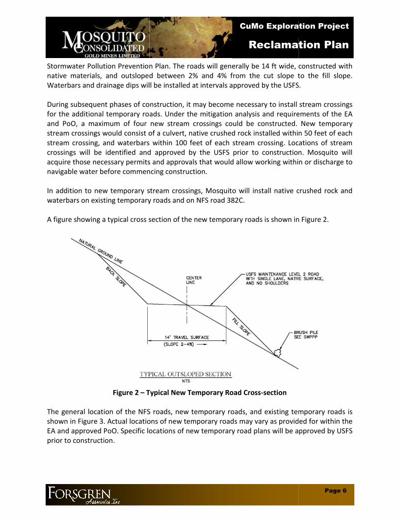
Stormwater Pollution Prevention Plan. The roads will generally be 14 ft wide, constructed withnative materials, and outsloped between 2% and 4% from the cut slope to the fill slopeWaterbars and drainage dips will be installed at inte
During subsequent phases of construction, it may become necessary to install stream crossingsfor the additional temporary roads. Under the mitigation analysis and requirements of the EAand PoO, a maximum of four new stream crstream crossings would consist of a culvert, native crushed rock installed within 50 feet of eachstream crossing, and waterbars within 100 feet of each stream crossing. Locations of streamcrossings will be identified and approved by the USFS prior to construction. Mosquito willacquire those necessary permits and approvals that would allow working within or discharge tonavigable water before commencing construction.
In addition to new temporary stream crossings, Mosquito will install native crushed rock andwaterbars on existing temporary roads and on NFS road 382C.
A figure showing a typical cross section of the new temporary roads is shown in Figure 2.
Figure 2 – Typical New Temporary Road Cross
The general location of the NFS roads, new temporary roads, and existing temporary roads isshown in Figure 3. Actual locations of new temporary roads may vary as provided for wiEA and approved PoO. Specific locations of new temporary road plans will be approved by USFSprior to construction.
CuMo Exploration Project
Reclamation Plan
Stormwater Pollution Prevention Plan. The roads will generally be 14 ft wide, constructed withnative materials, and outsloped between 2% and 4% from the cut slope to the fill slopeWaterbars and drainage dips will be installed at intervals approved by the USFS.
During subsequent phases of construction, it may become necessary to install stream crossingsfor the additional temporary roads. Under the mitigation analysis and requirements of the EAand PoO, a maximum of four new stream crossings could be constructed. New temporarystream crossings would consist of a culvert, native crushed rock installed within 50 feet of eachstream crossing, and waterbars within 100 feet of each stream crossing. Locations of stream
tified and approved by the USFS prior to construction. Mosquito willacquire those necessary permits and approvals that would allow working within or discharge tonavigable water before commencing construction.
In addition to new temporary stream crossings, Mosquito will install native crushed rock andwaterbars on existing temporary roads and on NFS road 382C.
A figure showing a typical cross section of the new temporary roads is shown in Figure 2.
Typical New Temporary Road Cross-section
The general location of the NFS roads, new temporary roads, and existing temporary roads isshown in Figure 3. Actual locations of new temporary roads may vary as provided for wiEA and approved PoO. Specific locations of new temporary road plans will be approved by USFS
Page 6
CuMo Exploration Project
Reclamation Plan
Stormwater Pollution Prevention Plan. The roads will generally be 14 ft wide, constructed withnative materials, and outsloped between 2% and 4% from the cut slope to the fill slope.
rvals approved by the USFS.
During subsequent phases of construction, it may become necessary to install stream crossingsfor the additional temporary roads. Under the mitigation analysis and requirements of the EA
ossings could be constructed. New temporarystream crossings would consist of a culvert, native crushed rock installed within 50 feet of eachstream crossing, and waterbars within 100 feet of each stream crossing. Locations of stream
tified and approved by the USFS prior to construction. Mosquito willacquire those necessary permits and approvals that would allow working within or discharge to
In addition to new temporary stream crossings, Mosquito will install native crushed rock and
A figure showing a typical cross section of the new temporary roads is shown in Figure 2.
The general location of the NFS roads, new temporary roads, and existing temporary roads isshown in Figure 3. Actual locations of new temporary roads may vary as provided for within theEA and approved PoO. Specific locations of new temporary road plans will be approved by USFS

LEGEND
PROJECT BOUNDARY
MAJOR COUNTOUR
MINOR CONTOUR
EXISTING USFS ROADS
NO
SC
AL
E
PROPOSED TEMPORARY ROADS UNDERALTERNATIVE B
EXISTING TEMPORARY ROADS
PR
OJ
EC
TN
O.:
SH
EE
TN
O.
Figu
re3
-Gen
eral
Roa
dLa
yout
Cum
oEx
plor
atio
nPr
ojec
t
1

2.3 Proposed Drill Pad Sites
Under requirements of the EA, Mosquito may construct up to 137 new drill pads. StormwaterBest Management Practices will be implemented in accordance with the CuMo ExplorationStormwater Pollution Prevention Plan. A typical drill pad willft wide with ends or sides contoured into the temporary access roads. Each drill pad will have acompartmentalized mud pit so that drill fluids will be retained onsite. Drill machines, lightlamps, spill kits, and ancillary tools and supplies will be kept at the drill pad locations. A servicepick-up truck will transport drillers, fuel, and daily drilling consumables during operations. Themud pits will generally be located on the drill pad site downgradient from drilling aallow drill fluids to flow into the pits. A typical drill pad configuration is shown in Figure 4.
CuMo Exploration Project
Reclamation Plan
Under requirements of the EA, Mosquito may construct up to 137 new drill pads. StormwaterBest Management Practices will be implemented in accordance with the CuMo ExplorationStormwater Pollution Prevention Plan. A typical drill pad will be approximately 60 ft long by 25ft wide with ends or sides contoured into the temporary access roads. Each drill pad will have acompartmentalized mud pit so that drill fluids will be retained onsite. Drill machines, light
y tools and supplies will be kept at the drill pad locations. A serviceup truck will transport drillers, fuel, and daily drilling consumables during operations. The
mud pits will generally be located on the drill pad site downgradient from drilling aallow drill fluids to flow into the pits. A typical drill pad configuration is shown in Figure 4.
Page 8
CuMo Exploration Project
Reclamation Plan
Under requirements of the EA, Mosquito may construct up to 137 new drill pads. StormwaterBest Management Practices will be implemented in accordance with the CuMo Exploration
be approximately 60 ft long by 25ft wide with ends or sides contoured into the temporary access roads. Each drill pad will have acompartmentalized mud pit so that drill fluids will be retained onsite. Drill machines, light
y tools and supplies will be kept at the drill pad locations. A serviceup truck will transport drillers, fuel, and daily drilling consumables during operations. The
mud pits will generally be located on the drill pad site downgradient from drilling activities toallow drill fluids to flow into the pits. A typical drill pad configuration is shown in Figure 4.

Figure
Notes:1. Figure represents a generalized
drill pad plan. Actual dimensionswill vary and will not exceed thoseshown.
2. “Oils” kept on-site include oil andgasoline for small equipment anddrill fluid additives. Oils will bestored in 5-gal or less containersand stored in a containment area toprevent accidental release to soil orto navigable waters.
3. Stormwater BMPs to beimplemented during construction.
4. Fresh water will be delivered to theMixing Tank by hose, pumped fromthe creek or stand pipe, or hauledin by truck.
CuMo Exploration Project
Reclamation Plan
Figure 4 –Typical Drill Pad Layout
and stored in a containment area toprevent accidental release to soil or
to theby hose, pumped from
Page 9
CuMo Exploration Project
Reclamation Plan

2.4 Acreage Affected by Surface Disturbance
This exploration project may involve construction of up to 10.2 miles of temporary access roadsand up to 137 drill pad sites. The EA notes that the temporary roads and drill pads would resultin a Detrimental Disturbance of up to 51.1disturbance throughout the entirety of the project will depend on accumulated data collectedduring preceding stages of exploration and the extent of future exploration. Mosquito will notexceed the length of temporary roads and number of drill pads evaluated as Alternative B in theFebruary 2011 Environmental Assessment
As a part of this Reclamation Plan, Mosquito also will reclaim existing temporary roads. Thoseroads are identified in Figure 3.
In collaboration with USFS, vegetation of areas slated for disturbance will be characterizedduring each phase of construction. Mosquito will utilize Potential Vegprovided by the USFS to overlay onto USFS approved road alignments and drill padThis will enable Mosquito to identify potential candidate species for reclamation and to plan forappropriate revegetation.
2.5 Topsoil Conservation
Topsoil is a critical component of our reclamation strategy because it is the critical mediumwhich each area’s pre-disturbance vegetation grew. For this reason, care will be taken toremove primarily topsoil and not “contaminate” it with subsoil. Once the topsoil is carefullyremoved, it will be stored in selected sites near the disturbed siteminimize its loss through erosion and storm water runoff.will be removed and transported with front loaders or graders.
Site specific topsoil depths will be identified prior to disturbance.identified in the field and stored outside of Riparian Conservation Areasof noxious weeds. Topsoil stockpiles will be managed per IDEQ’s Stockpile Management BestManagement Practice (BMP 9). A summary of stockpile management practices is includedbelow.
Stockpiles will be located a minimum of 50 feet away from concentrated flows ofstormwater, drainage courses, and inlets and outside of Riparian Conservation Areas.
Stockpiles will be protected from stormwater runsediment barrier such as berms, dikes, fiber rolls, silt fences, sandbags, or gravel bags.
If the stockpile is located in an area with high winds, wind erosion control practices willbe utilized.
Any bagged materials will be kept on pallets and under cover.
CuMo Exploration Project
Reclamation Plan
Surface Disturbance
This exploration project may involve construction of up to 10.2 miles of temporary access roadsand up to 137 drill pad sites. The EA notes that the temporary roads and drill pads would resultin a Detrimental Disturbance of up to 51.1 acres (USDA EA page 61). Total actual surfacedisturbance throughout the entirety of the project will depend on accumulated data collectedduring preceding stages of exploration and the extent of future exploration. Mosquito will not
temporary roads and number of drill pads evaluated as Alternative B in theFebruary 2011 Environmental Assessment.
As a part of this Reclamation Plan, Mosquito also will reclaim existing temporary roads. Those
ration with USFS, vegetation of areas slated for disturbance will be characterizedduring each phase of construction. Mosquito will utilize Potential Vegetation Group mappingprovided by the USFS to overlay onto USFS approved road alignments and drill padThis will enable Mosquito to identify potential candidate species for reclamation and to plan for
Topsoil is a critical component of our reclamation strategy because it is the critical mediumdisturbance vegetation grew. For this reason, care will be taken to
remove primarily topsoil and not “contaminate” it with subsoil. Once the topsoil is carefullyremoved, it will be stored in selected sites near the disturbed site and actively managed tominimize its loss through erosion and storm water runoff. Depending on site conditions, topsoilwill be removed and transported with front loaders or graders.
Site specific topsoil depths will be identified prior to disturbance. Topsoil stockpilesstored outside of Riparian Conservation Areas and in areas
. Topsoil stockpiles will be managed per IDEQ’s Stockpile Management BestManagement Practice (BMP 9). A summary of stockpile management practices is included
Stockpiles will be located a minimum of 50 feet away from concentrated flows ofer, drainage courses, and inlets and outside of Riparian Conservation Areas.
Stockpiles will be protected from stormwater run-on using a temporary perimetersediment barrier such as berms, dikes, fiber rolls, silt fences, sandbags, or gravel bags.
tockpile is located in an area with high winds, wind erosion control practices will
Any bagged materials will be kept on pallets and under cover.
Page 10
CuMo Exploration Project
Reclamation Plan
This exploration project may involve construction of up to 10.2 miles of temporary access roadsand up to 137 drill pad sites. The EA notes that the temporary roads and drill pads would result
acres (USDA EA page 61). Total actual surfacedisturbance throughout the entirety of the project will depend on accumulated data collectedduring preceding stages of exploration and the extent of future exploration. Mosquito will not
temporary roads and number of drill pads evaluated as Alternative B in the
As a part of this Reclamation Plan, Mosquito also will reclaim existing temporary roads. Those
ration with USFS, vegetation of areas slated for disturbance will be characterizedetation Group mapping
provided by the USFS to overlay onto USFS approved road alignments and drill pad locations.This will enable Mosquito to identify potential candidate species for reclamation and to plan for
Topsoil is a critical component of our reclamation strategy because it is the critical medium indisturbance vegetation grew. For this reason, care will be taken to
remove primarily topsoil and not “contaminate” it with subsoil. Once the topsoil is carefullyand actively managed to
Depending on site conditions, topsoil
Topsoil stockpiles will beand in areas “cleared”
. Topsoil stockpiles will be managed per IDEQ’s Stockpile Management BestManagement Practice (BMP 9). A summary of stockpile management practices is included
Stockpiles will be located a minimum of 50 feet away from concentrated flows ofer, drainage courses, and inlets and outside of Riparian Conservation Areas.
on using a temporary perimetersediment barrier such as berms, dikes, fiber rolls, silt fences, sandbags, or gravel bags.
tockpile is located in an area with high winds, wind erosion control practices will

During the rainy season, soil stockpiles will be covered or protected with soilstabilization measures and a temporary perimeter sediment barrier at all times.
During the non-rainy season, soil stockpiles will be covered or protected with atemporary perimeter sediment barrier prior to onset of precipitation.
The full BMP for stockpile management, including installation details, is included in Appendix Band in the CuMo Exploration Stormwater Pollution Prevention Plan. An electronic copy can befound on the Idaho Department of Environmental Quality website at:
http://www.deq.idaho.gov/water/ data_reports/storm_water/catalog/sec_2/bmps/9.pdf
CuMo Exploration Project
Reclamation Plan
During the rainy season, soil stockpiles will be covered or protected with soilsures and a temporary perimeter sediment barrier at all times.
rainy season, soil stockpiles will be covered or protected with atemporary perimeter sediment barrier prior to onset of precipitation.
The full BMP for stockpile management, including installation details, is included in Appendix Band in the CuMo Exploration Stormwater Pollution Prevention Plan. An electronic copy can befound on the Idaho Department of Environmental Quality website at:
http://www.deq.idaho.gov/water/ data_reports/storm_water/catalog/sec_2/bmps/9.pdf
Page 11
CuMo Exploration Project
Reclamation Plan
During the rainy season, soil stockpiles will be covered or protected with soilsures and a temporary perimeter sediment barrier at all times.
rainy season, soil stockpiles will be covered or protected with a
The full BMP for stockpile management, including installation details, is included in Appendix Band in the CuMo Exploration Stormwater Pollution Prevention Plan. An electronic copy can be
http://www.deq.idaho.gov/water/ data_reports/storm_water/catalog/sec_2/bmps/9.pdf

3.0 RECLAMATION
Mosquito has identified a series of actions to conform to reclamation measures in accordancewith the EA and PoO and to enhance the likelihood of reclamatactions are listed below and described in greater detail in subsequent sections.
Chemically analyzing and assessing topsoil quality.
Re-contouring subsoil.
Spreading retained topsoil over the re
Based on soil test results, amend soil to correct noted deficiencies and optimize it forgrowing reclamation plants.
Planting seeds reflective of the areas pre
Monitoring planted areas to assess germination of desired species and the need forremoving unwanted species (i.e., weeds).
Monitoring to determine the degree to which the vegetation of the planted areamatches the vegetation of the area prior to disturbance.
Once vegetation of the restored area is similar to the area’s prevegetation, the site is considered restored.
It should be noted that Lewisia Sacajaweanaand therefore the subject of additional measures to identify, avoid, monitor, reclaim and/ormitigate it. Our primary strategy related to this plant species is avoidance. That is, Mosquiwork closely with the USFS botanists and other resource specialists to locate and conduct itsactivities in order to avoid L. sacajaweanasacajaweana by the CuMo exploration project causes an approximate loss of 10% ospecific reclamation and/or mitigation measures will be utilized as identified in theSacajaweana Inventory/Monitoring Plan with Reclamation /Mitigation Examplesfor this project.
3.1 Chemically Analyzing and Assessing Topsoil
Mosquito will collect representative samples and have them analyzed by a reputable soiltesting lab using competent personnel, acceptable procedures, and calibrated analyticalequipment. The analyses will seek to identify soil deficiencies thaappropriate soil amendments. Soil deficiencies can range from infertility where crucial plantnutrients (e.g., nitrogen, phosphorus, or potassium) may be lacking to soil structure wherewater retention is suboptimal (e.g, a verthat might be added to alleviate such identified deficiencies include fertilizers to improvefertility, elemental sulfur to lower soil pH, and organic matter to improve moisture retention.
CuMo Exploration Project
Reclamation Plan
Mosquito has identified a series of actions to conform to reclamation measures in accordancewith the EA and PoO and to enhance the likelihood of reclamation success. Specific reclamationactions are listed below and described in greater detail in subsequent sections.
Chemically analyzing and assessing topsoil quality.
Spreading retained topsoil over the re-contoured subsoil.
n soil test results, amend soil to correct noted deficiencies and optimize it forgrowing reclamation plants.
Planting seeds reflective of the areas pre-disturbance flora.
Monitoring planted areas to assess germination of desired species and the need foremoving unwanted species (i.e., weeds).
Monitoring to determine the degree to which the vegetation of the planted areamatches the vegetation of the area prior to disturbance.
Once vegetation of the restored area is similar to the area’s prevegetation, the site is considered restored.
Lewisia Sacajaweana (Sacajawea’s Bitterroot) is a Forest Watch speciesand therefore the subject of additional measures to identify, avoid, monitor, reclaim and/ormitigate it. Our primary strategy related to this plant species is avoidance. That is, Mosqui
ly with the USFS botanists and other resource specialists to locate and conduct itsL. sacajaweana if possible. In the event that disturbance of
by the CuMo exploration project causes an approximate loss of 10% ospecific reclamation and/or mitigation measures will be utilized as identified in theSacajaweana Inventory/Monitoring Plan with Reclamation /Mitigation Examples
Chemically Analyzing and Assessing Topsoil for Quality
Mosquito will collect representative samples and have them analyzed by a reputable soiltesting lab using competent personnel, acceptable procedures, and calibrated analyticalequipment. The analyses will seek to identify soil deficiencies that may be rectified by addingappropriate soil amendments. Soil deficiencies can range from infertility where crucial plantnutrients (e.g., nitrogen, phosphorus, or potassium) may be lacking to soil structure wherewater retention is suboptimal (e.g, a very sandy soil with little organic matter). Amendmentsthat might be added to alleviate such identified deficiencies include fertilizers to improvefertility, elemental sulfur to lower soil pH, and organic matter to improve moisture retention.
Page 12
CuMo Exploration Project
Reclamation Plan
Mosquito has identified a series of actions to conform to reclamation measures in accordanceion success. Specific reclamation
n soil test results, amend soil to correct noted deficiencies and optimize it for
Monitoring planted areas to assess germination of desired species and the need for
Monitoring to determine the degree to which the vegetation of the planted area
Once vegetation of the restored area is similar to the area’s pre-disturbance
(Sacajawea’s Bitterroot) is a Forest Watch speciesand therefore the subject of additional measures to identify, avoid, monitor, reclaim and/ormitigate it. Our primary strategy related to this plant species is avoidance. That is, Mosquito will
ly with the USFS botanists and other resource specialists to locate and conduct itsif possible. In the event that disturbance of L.
by the CuMo exploration project causes an approximate loss of 10% of plants,specific reclamation and/or mitigation measures will be utilized as identified in the LewisiaSacajaweana Inventory/Monitoring Plan with Reclamation /Mitigation Examples plan prepared
Mosquito will collect representative samples and have them analyzed by a reputable soiltesting lab using competent personnel, acceptable procedures, and calibrated analytical
t may be rectified by addingappropriate soil amendments. Soil deficiencies can range from infertility where crucial plantnutrients (e.g., nitrogen, phosphorus, or potassium) may be lacking to soil structure where
y sandy soil with little organic matter). Amendmentsthat might be added to alleviate such identified deficiencies include fertilizers to improvefertility, elemental sulfur to lower soil pH, and organic matter to improve moisture retention.

3.2 Re-Contouring Subsoil
Re-contouring the subsoil involves reshaping the disturbed area to approximate the predisturbance land form and topography. Procedures for recontouring are described below:
3.2.1 Road ReclamationExploration roads, drill sites, and sumps will be backfilled and recontoured using a CAT345C excavator or other suitable sized excavator. Gates off the USFS Roads C382C andC397B will be removed and properly disposed of. Soil material that is placed in roduring construction will be replaced (backfilled) into the road cuts and on drill sites bythe excavator. To reduce the risk of sloughing,compacted with constructionin rough condition to hold seed and to optimize germination, and recontoured roadsand drill sites will be seeded.
3.2.1.1 Roads on Slopes Less than 20%Roads will be recontoured using a combination of partial recontouring andripping. The toe of cut and fill slopes will be smoothed and all disturbed areaswill be revegetated in accordance with this plan. Figure 5 shows approximaterecontouring for moderate and shallow slopes.
Figure 5 – Moderate and Shallow Slope Recontouring
3.2.1.2 Roads on Slopes Greater than 20%Reclamation of temporary roads on slopes greater than 20% will be backfilledand recontoured to the approximate original contodescribed in this plan. Figure 6 depicts approximate recontouring for roads onsteep slopes.
Existing Slope
CuMo Exploration Project
Reclamation Plan
contouring the subsoil involves reshaping the disturbed area to approximate the predisturbance land form and topography. Procedures for recontouring are described below:
Road ReclamationExploration roads, drill sites, and sumps will be backfilled and recontoured using a CAT345C excavator or other suitable sized excavator. Gates off the USFS Roads C382C andC397B will be removed and properly disposed of. Soil material that is placed in roduring construction will be replaced (backfilled) into the road cuts and on drill sites by
To reduce the risk of sloughing, soils will be placed in layerconstruction equipment. The final surface of backfilled sites will be left
in rough condition to hold seed and to optimize germination, and recontoured roadsand drill sites will be seeded.
Roads on Slopes Less than 20%Roads will be recontoured using a combination of partial recontouring and
e toe of cut and fill slopes will be smoothed and all disturbed areaswill be revegetated in accordance with this plan. Figure 5 shows approximaterecontouring for moderate and shallow slopes.
Moderate and Shallow Slope Recontouring
Roads on Slopes Greater than 20%Reclamation of temporary roads on slopes greater than 20% will be backfilledand recontoured to the approximate original contour and then revegetated asdescribed in this plan. Figure 6 depicts approximate recontouring for roads on
Temporary Road
Recontoured Slope
Page 13
CuMo Exploration Project
Reclamation Plan
contouring the subsoil involves reshaping the disturbed area to approximate the pre-disturbance land form and topography. Procedures for recontouring are described below:
Exploration roads, drill sites, and sumps will be backfilled and recontoured using a CAT345C excavator or other suitable sized excavator. Gates off the USFS Roads C382C andC397B will be removed and properly disposed of. Soil material that is placed in road fillduring construction will be replaced (backfilled) into the road cuts and on drill sites by
soils will be placed in layers andilled sites will be left
in rough condition to hold seed and to optimize germination, and recontoured roads
Roads will be recontoured using a combination of partial recontouring ande toe of cut and fill slopes will be smoothed and all disturbed areas
will be revegetated in accordance with this plan. Figure 5 shows approximate
Reclamation of temporary roads on slopes greater than 20% will be backfilledur and then revegetated as
described in this plan. Figure 6 depicts approximate recontouring for roads on

Figure
3.2.1.3 Stream CrossingsPlant species within the ordinary water line of tributaries of Grimes Creek whichare to be removed for the placement of culverts and crushed rock will bedocumented and photographed in order to facilitate subsequent reclamation.Native crushed rock, water bars, and culverts placed in stream crossings will beremoved and the ground revegetated and returned back to approximatedisturbance conditionconsultation with USFS resource specialists and m
In areas where Mosquito places native crushed rock and water bars adjacent toexisting culverts on USFS roads, that rock and those water bars will be left inplace per USFS direction
Before commencing operations, Mosquito will acquireapprovals, including 401 certifications, that would entail working within orpotential discharges to navigable water.
3.2.2 Drill Pad ReclamationEquipment, construction debris, all associated materials, and trash will be removed frothe site.
3.2.2.1 Mud Pit ReclamationMud pits will be allowed to dry and after a period of settling that will varydepending upon weather and ground conditions, the pits will be filled insubsoil stored from pit excavationcontour.
Existing
CuMo Exploration Project
Reclamation Plan
Figure 6 – Steep Slope Recontouring
Stream CrossingsPlant species within the ordinary water line of tributaries of Grimes Creek whichare to be removed for the placement of culverts and crushed rock will bedocumented and photographed in order to facilitate subsequent reclamation.Native crushed rock, water bars, and culverts placed in stream crossings will beremoved and the ground revegetated and returned back to approximatedisturbance condition. Crushed gravel disposal areas will be determined inconsultation with USFS resource specialists and may be off-site.
In areas where Mosquito places native crushed rock and water bars adjacent toexisting culverts on USFS roads, that rock and those water bars will be left in
direction.
Before commencing operations, Mosquito will acquire all necessary permits andapprovals, including 401 certifications, that would entail working within orpotential discharges to navigable water.
Drill Pad ReclamationEquipment, construction debris, all associated materials, and trash will be removed fro
Mud Pit ReclamationMud pits will be allowed to dry and after a period of settling that will varydepending upon weather and ground conditions, the pits will be filled in
stored from pit excavation and recontoured to approximate
Existing & Recontoured Slope
Temporary Road
Page 14
CuMo Exploration Project
Reclamation Plan
Plant species within the ordinary water line of tributaries of Grimes Creek whichare to be removed for the placement of culverts and crushed rock will bedocumented and photographed in order to facilitate subsequent reclamation.Native crushed rock, water bars, and culverts placed in stream crossings will beremoved and the ground revegetated and returned back to approximate its pre-
Crushed gravel disposal areas will be determined in
In areas where Mosquito places native crushed rock and water bars adjacent toexisting culverts on USFS roads, that rock and those water bars will be left in
all necessary permits andapprovals, including 401 certifications, that would entail working within or
Equipment, construction debris, all associated materials, and trash will be removed from
Mud pits will be allowed to dry and after a period of settling that will varydepending upon weather and ground conditions, the pits will be filled in with
approximate their original

3.2.2.2 Drill Hole Abandonment ProcedureExploration drill holes will be abandoned in compliance with applicable USFS andIdaho Department of Lands requirements (as well as Idaho Department of WaterResources, as applicable). In general, ecompletion of drilling and prior to demobilization of the drill rig from the hole. Itis Mosquito’s intent that no more thanHowever, in consultation with the Minerals Adminisrequest that more than four drill holes be allowed to remain open in order tofacilitate and shorten the overall exploration program. Standard procedures toabandon each drill hole will include the use of Super Plug, which is manufactuby M-I Swaco. Super Plug is a proprietary blend of bentonite, hydroxides, andsilicates designed to minimize environmental impacts in hole abandonmentapplications. It is a 100% inorganic additive that hydrates easily and setsefficiently. The Super Pldrill hole with a tremie pipe, which will be withdrawn as grout fills the drill hole.This technique will minimize or avoid air gaps as the drill hole is filled. The groutwill be tremmied tofrom 5 feet below ground surface to the surfacehole will be removed when its associated drill pad is reclaimed in accord withthis Reclamation Plan.
Exploration test holes are excluded from Idaho Drilling Permit(IDAPA 37.09.09 Rule 45 Subsection 045.03). Therefore, no Idaho Department ofWater Resources drilling permits or completion of authorizationforms will be necessary.
3.2.2.3 Drill Pad Site ContouringDill Pad sites on moderate to shallowcombination of partial recontouring and ripping. The toe of cut and fill slopes atthe edges of the drill pad will be smoothed. Drill pads sites on steep (greaterthan 20%) slopes will be recontoured by means of backfilliof the ground. To reduce the risk of sloughing, soils will be placed in layers andcompacted with construction equipment.in accordance with this plan.
3.3 Spreading Retained Topsoil Over
Once subsoil re-contouring is complete, retained topsoil will be spread evenly over the subsoilsurface in an effort to approximate preapplying it unevenly may subsequently resultminimize erosion from wind and storm water runoff will be employed as necessary.
CuMo Exploration Project
Reclamation Plan
Drill Hole Abandonment ProcedureExploration drill holes will be abandoned in compliance with applicable USFS andIdaho Department of Lands requirements (as well as Idaho Department of WaterResources, as applicable). In general, each drill hole will be abandoned uponcompletion of drilling and prior to demobilization of the drill rig from the hole. Itis Mosquito’s intent that no more than four drill holes remain open at one time.However, in consultation with the Minerals Administrator, Mosquito mayrequest that more than four drill holes be allowed to remain open in order tofacilitate and shorten the overall exploration program. Standard procedures toabandon each drill hole will include the use of Super Plug, which is manufactu
I Swaco. Super Plug is a proprietary blend of bentonite, hydroxides, andsilicates designed to minimize environmental impacts in hole abandonmentapplications. It is a 100% inorganic additive that hydrates easily and setsefficiently. The Super Plug additive will be introduced into the bottom of eachdrill hole with a tremie pipe, which will be withdrawn as grout fills the drill hole.This technique will minimize or avoid air gaps as the drill hole is filled. The groutwill be tremmied to 5 feet below ground surface. A concrete plug will befrom 5 feet below ground surface to the surface. Surface evidence of each
will be removed when its associated drill pad is reclaimed in accord withthis Reclamation Plan.
Exploration test holes are excluded from Idaho Drilling Permit(IDAPA 37.09.09 Rule 45 Subsection 045.03). Therefore, no Idaho Department ofWater Resources drilling permits or completion of authorizationforms will be necessary.
Drill Pad Site ContouringDill Pad sites on moderate to shallow slopes will be recontoured using acombination of partial recontouring and ripping. The toe of cut and fill slopes atthe edges of the drill pad will be smoothed. Drill pads sites on steep (greaterthan 20%) slopes will be recontoured by means of backfilling to the original slope
To reduce the risk of sloughing, soils will be placed in layers andcompacted with construction equipment. All disturbed areas will be revegetatedin accordance with this plan.
Spreading Retained Topsoil Over Recontoured Subsoil
contouring is complete, retained topsoil will be spread evenly over the subsoilsurface in an effort to approximate pre-disturbance conditions. Applying too little topsoil orapplying it unevenly may subsequently result in poor plant growth. Provisions to prevent orminimize erosion from wind and storm water runoff will be employed as necessary.
Page 15
CuMo Exploration Project
Reclamation Plan
Exploration drill holes will be abandoned in compliance with applicable USFS andIdaho Department of Lands requirements (as well as Idaho Department of Water
ach drill hole will be abandoned uponcompletion of drilling and prior to demobilization of the drill rig from the hole. It
holes remain open at one time.trator, Mosquito may
request that more than four drill holes be allowed to remain open in order tofacilitate and shorten the overall exploration program. Standard procedures toabandon each drill hole will include the use of Super Plug, which is manufactured
I Swaco. Super Plug is a proprietary blend of bentonite, hydroxides, andsilicates designed to minimize environmental impacts in hole abandonmentapplications. It is a 100% inorganic additive that hydrates easily and sets
introduced into the bottom of eachdrill hole with a tremie pipe, which will be withdrawn as grout fills the drill hole.This technique will minimize or avoid air gaps as the drill hole is filled. The grout
ground surface. A concrete plug will be placed. Surface evidence of each drill
will be removed when its associated drill pad is reclaimed in accord with
Exploration test holes are excluded from Idaho Drilling Permit Requirements(IDAPA 37.09.09 Rule 45 Subsection 045.03). Therefore, no Idaho Department ofWater Resources drilling permits or completion of authorization-to-abandon
econtoured using acombination of partial recontouring and ripping. The toe of cut and fill slopes atthe edges of the drill pad will be smoothed. Drill pads sites on steep (greater
ng to the original slopeTo reduce the risk of sloughing, soils will be placed in layers and
All disturbed areas will be revegetated
contouring is complete, retained topsoil will be spread evenly over the subsoildisturbance conditions. Applying too little topsoil or
in poor plant growth. Provisions to prevent orminimize erosion from wind and storm water runoff will be employed as necessary.

3.4 Applying Amendment To Address Soil Deficiencies
If soil analysis reveals soil deficiencies,resource specialists, to approximate local presolid granular, solid powder, or liquid form. Such amendments may be worked into the soilusing mechanical means such as disking or harrowing, but again, in consultation with USFSresource specialists.
3.5 Planting Seeds Reflective of the Area’s Pre
Seed mixes reflective of the floraof this reclamation strategy. The final seed mix will be decided upon in consultation with theDistrict Botanist. Seed and plant propagules will be reviewed and approved by USFS to verifyquality standards and provenance. Furthermore, the seed mix will be tested by the Idaho StateSeed Lab as source-identified seed. Figure 7, provided by the USFS botanist, denotes that fourPotential Vegetation Groups (PVG) fall within the project area, i.e., PHowever, all the drill sites and access roads requiring reclamation apparently fall within PVGs,#2 and #7.
Figure 7 – Potential Vegetation Groups (PVG) for Project Area
CuMo Exploration Project
Reclamation Plan
Applying Amendment To Address Soil Deficiencies
If soil analysis reveals soil deficiencies, amendments may be added, in consultation with USFSresource specialists, to approximate local pre-disturbance conditions. Amendments may be insolid granular, solid powder, or liquid form. Such amendments may be worked into the soil
such as disking or harrowing, but again, in consultation with USFS
Planting Seeds Reflective of the Area’s Pre-Disturbance Flora
Seed mixes reflective of the flora of the area in its pre-disturbance state will be a key elementThe final seed mix will be decided upon in consultation with the
District Botanist. Seed and plant propagules will be reviewed and approved by USFS to verifyity standards and provenance. Furthermore, the seed mix will be tested by the Idaho State
identified seed. Figure 7, provided by the USFS botanist, denotes that fourPotential Vegetation Groups (PVG) fall within the project area, i.e., PVG #2, #4, #7 and #8.However, all the drill sites and access roads requiring reclamation apparently fall within PVGs,
Potential Vegetation Groups (PVG) for Project Area
Page 16
CuMo Exploration Project
Reclamation Plan
amendments may be added, in consultation with USFSAmendments may be in
solid granular, solid powder, or liquid form. Such amendments may be worked into the soilsuch as disking or harrowing, but again, in consultation with USFS
disturbance state will be a key elementThe final seed mix will be decided upon in consultation with the
District Botanist. Seed and plant propagules will be reviewed and approved by USFS to verifyity standards and provenance. Furthermore, the seed mix will be tested by the Idaho State
identified seed. Figure 7, provided by the USFS botanist, denotes that fourVG #2, #4, #7 and #8.
However, all the drill sites and access roads requiring reclamation apparently fall within PVGs,
Potential Vegetation Groups (PVG) for Project Area

Potential seed diversity and percentages for the project are provided in Tables 1 and 2, whichhave been prepared in collaboration with the USFS district botanist.or seed procurement, inadequate suppliesdistrict botanist to determine an acceptable alternative mix.
Seed Mixes for Potential Vegetation Groups #2 and #7
PVG #2
Scientific Name Common NameCalamagrostis rubescens
Festuca idahoensis
Poa wheeleri Wheeler’s bluegrass
Amelanchier alnifolia Saskatoon serviceberry
Pinus ponderosa Ponderosa pine
Symphoricarpos albus Common snowberry
Rosa spp. Various native roses
Ribes cereum
Achillea millefolium Common yarrow
Arabis cobrensis Sagebrush rockcress
Penstemon wilcoxii Wilcox’s penstemon
Diversity of Seeds to be Collected for Potential Vegetation Groups #2 and #7
PVG #2
Common NamePinegrass
Idaho fescue
Wheeler’s bluegrass
Saskatoon serviceberry
Ponderosa pine
Common snowberry
Various native roses
Wax currant
Common yarrow
Sagebrush rockcress
Wilcox’s penstemon
The actual amount of required seed will be based on the total area disturbed during explorationand those existing temporary roads within the project boundary that will be reclaimed. The EAestimates that up to 69 acres of vegetation will be cleared as a rdrill pad construction (EA page 75, Table 9)significantly less than 69 acres. Exploration will be completed in phases with future activitiesbeing dependent upon results from previous phases. Because the extent of future phasesunknown at this time, the total amount of disturbed land is also unknown. As explorationproceeds and future phases are defined, the areas of disturbance and required amounts of
CuMo Exploration Project
Reclamation Plan
Potential seed diversity and percentages for the project are provided in Tables 1 and 2, whichhave been prepared in collaboration with the USFS district botanist. If, at the time of collectionor seed procurement, inadequate supplies are available, Mosquito will work with the USFSdistrict botanist to determine an acceptable alternative mix.
Table 1 – Seed MixesSeed Mixes for Potential Vegetation Groups #2 and #7
PVG #7
Common Name Scientific Name CommonPinegrass Psuedotsuga menziesii Rocky Mtn. Douglas fir
Idaho fescue Acer glabrum Rocky Mtn. maple
Wheeler’s bluegrass Amelanchier alnifolia Saskatoon serviceberry
Saskatoon serviceberry Prunus virginiana
Ponderosa pine Penstemon wilcoxii Wilcox’s penstemon
Common snowberry Bromus vulgaris Columbia brome
Various native roses Calamagrostis rubescens
Wax currant Arabis cobrensis Sagebrush rockcress
Common yarrow Achillea millefolium Common yarrow
Sagebrush rockcress
Wilcox’s penstemon
Table 2 – Seed DiversityDiversity of Seeds to be Collected for Potential Vegetation Groups #2 and #7
PVG #2 PVG #7
% of Total Common Name % of Total9.2 Rocky Mtn. Douglas fir 5.8
36.8 Rocky Mtn. maple 11.7
9.2 Saskatoon serviceberry 11.7
9.2 Chokecherry 17.5
4.6 Wilcox’s penstemon 2.9
9.2 Columbia brome 35.0
13.8 Pinegrass 11.7
4.6 Sagebrush rockcress 2.9
0.6 Common yarrow 0.7
0.6
2.3
The actual amount of required seed will be based on the total area disturbed during explorationand those existing temporary roads within the project boundary that will be reclaimed. The EAestimates that up to 69 acres of vegetation will be cleared as a result of temporary road and
(EA page 75, Table 9). However, the actual area disturbed may besignificantly less than 69 acres. Exploration will be completed in phases with future activitiesbeing dependent upon results from previous phases. Because the extent of future phases
time, the total amount of disturbed land is also unknown. As explorationproceeds and future phases are defined, the areas of disturbance and required amounts of
Page 17
CuMo Exploration Project
Reclamation Plan
Potential seed diversity and percentages for the project are provided in Tables 1 and 2, whichIf, at the time of collection
to will work with the USFS
Common NameRocky Mtn. Douglas fir
Rocky Mtn. maple
Saskatoon serviceberry
Chokecherry
Wilcox’s penstemon
Columbia brome
Pinegrass
Sagebrush rockcress
Common yarrow
Diversity of Seeds to be Collected for Potential Vegetation Groups #2 and #7
% of Total5.8
11.7
11.7
17.5
2.9
35.0
11.7
2.9
0.7
The actual amount of required seed will be based on the total area disturbed during explorationand those existing temporary roads within the project boundary that will be reclaimed. The EA
esult of temporary road andHowever, the actual area disturbed may be
significantly less than 69 acres. Exploration will be completed in phases with future activitiesbeing dependent upon results from previous phases. Because the extent of future phases is
time, the total amount of disturbed land is also unknown. As explorationproceeds and future phases are defined, the areas of disturbance and required amounts of

seed will be refined. Table 3 shows the approximate seeding acreages for the first phase ofactivity, including reclamation of existing temporary roads.
Table 3 –
Affected Area
Existing Temporary Access Roads
Stage 1 Temporary Access Roads
Existing Drill Pads
Stage 1 Drill Pads
Seed collection methods will be selected according to particular groups of plants. Table 4summarizes methods that may be employed for each plant group.
TablePlant Group
Grasses
Berries
Select forbs (e.g., Yarrow,Penstemon)
Trees
All collected seeds will be labeled to providestatus. An example label is shown in Figure 8. If seeds are supplied by a certified supplier,Mosquito will confirm that seed tags include species identity, origin and test status inaccordance with this Reclamation Plan. Mosquito will forward copies of Seed Analysis Reportsand certification tags to the USFS district botanist for review prior to planting.
CuMo Exploration Project
Reclamation Plan
seed will be refined. Table 3 shows the approximate seeding acreages for the first phase oftivity, including reclamation of existing temporary roads.
– Approximate Phase 1 Seeding Acreages
Miles orNumber of Drill Pads
Stage 1Disturbed Acres
Existing Temporary Access Roads 4.7 17.1
Temporary Access Roads 2.4 8.7
34 1.2
32 1.1
Total 28.1
Seed collection methods will be selected according to particular groups of plants. Table 4summarizes methods that may be employed for each plant group.
Table 4 – Seed Collection MethodsPlant Group Seed Collection Method
Grasses Flail
Berries Hand-collected
Select forbs (e.g., Yarrow,Penstemon)
Vacuum sucker
Trees Hand-collected
All collected seeds will be labeled to provide information on species identity, origin, and teststatus. An example label is shown in Figure 8. If seeds are supplied by a certified supplier,Mosquito will confirm that seed tags include species identity, origin and test status in
eclamation Plan. Mosquito will forward copies of Seed Analysis Reportsand certification tags to the USFS district botanist for review prior to planting.
Page 18
CuMo Exploration Project
Reclamation Plan
seed will be refined. Table 3 shows the approximate seeding acreages for the first phase of
Stage 1Disturbed Acres
Seed collection methods will be selected according to particular groups of plants. Table 4
information on species identity, origin, and teststatus. An example label is shown in Figure 8. If seeds are supplied by a certified supplier,Mosquito will confirm that seed tags include species identity, origin and test status in
eclamation Plan. Mosquito will forward copies of Seed Analysis Reports

Conservation Seeding and Restoration, Inc.
506 Center Street West
Kimberly, Idaho 83341
(208) 423-4835
Species
Galleta Grass
Sandberg Bluegrass
Indian Ricegrass
Bottlebrush Squirreltail
Thickspike Wheatgrass
Other Crop:
Weed Seed:
Bulk lbs:
Site Application(s):
Where drilling activities result in compaction of the soil, ripping, disking, or other means will beused in areas to be revegetated to eliminate compaction and to establish a suitable root zone inpreparation for planting.
Mosquito will use the services of Conservation Seeding and Restoration, Kimberley, Idaho, oranother similarly qualified contractor, to identify planting techniques to attain maximum seedgermination and plant survival. These techniques may include broadcast seeding, drop seeding,drill seeding, hydroseeding, andseeding methods do not result in adequate germination and reclamation, or if seedling plantingmay result in higher survival rates or quicker establishment times for cert
The following BMPs from the Idaho Department of Lands Best Management Practices forMining in Idaho guidance will be utilized for planting.
CuMo Exploration Project
Reclamation Plan
Conservation Seeding and Restoration, Inc.
PureSeed %
Total Viable Tested
25.53 89 10/12/2010
10.89 79 10/12/2010
38.63 79 10/12/2010
7.95 83 10/12/2010
9.68 96 10/12/2010
0.38HardSeed: 0.00
0.05Inert
Matter: 6.91 Lot # 11001
MIX 14546.49 PLS lbs: 36.00
Figure 8 – Example Label
Where drilling activities result in compaction of the soil, ripping, disking, or other means will beused in areas to be revegetated to eliminate compaction and to establish a suitable root zone in
of Conservation Seeding and Restoration, Kimberley, Idaho, oranother similarly qualified contractor, to identify planting techniques to attain maximum seedgermination and plant survival. These techniques may include broadcast seeding, drop seeding,
seeding, hydroseeding, and seedling planting. Seedling planting may be used if otherseeding methods do not result in adequate germination and reclamation, or if seedling plantingmay result in higher survival rates or quicker establishment times for certain species.
The following BMPs from the Idaho Department of Lands Best Management Practices forMining in Idaho guidance will be utilized for planting.
Page 19
CuMo Exploration Project
Reclamation Plan
Origin
10/12/2010 TX
10/12/2010 WA
10/12/2010 WA
10/12/2010 WA
10/12/2010 WA
Lot # 11001
MIX 145
Where drilling activities result in compaction of the soil, ripping, disking, or other means will beused in areas to be revegetated to eliminate compaction and to establish a suitable root zone in
of Conservation Seeding and Restoration, Kimberley, Idaho, oranother similarly qualified contractor, to identify planting techniques to attain maximum seedgermination and plant survival. These techniques may include broadcast seeding, drop seeding,
seedling planting. Seedling planting may be used if otherseeding methods do not result in adequate germination and reclamation, or if seedling planting
ain species.
The following BMPs from the Idaho Department of Lands Best Management Practices for

II.2 Seedbed PreparationII.3 General Planting and SeedingII.4 Broadcast SeedingII.5 Drill SeedingII.8 Fertilizer Use
Copies of these BMPs are included in Appendix B. Electronic copies can be found on the IdahoDepartment of Lands website at:
http://www.idl.idaho.gov/bureau/Minerals/bmp_manual1992/bmp1992ttl.pdf
3.6 Monitoring To Assess Germination An
Monitoring of each replanted area will be initiated in the first spring following planting. Thefocus of the first monitoring effort will be to assess germination success from the recentseeding, whether or not weeds are appearing, anderosion is apparent, actions will be taken to prevent or minimize further erosion.
3.7 Comparing Vegetation of Planted Areas to that of Nearby Areas and Records of PreDisturbance State
Mosquito, or a USFS-approved Moaccess roads annually, comparing each to an adjacent reference area as well as documentingtheir pre-disturbance status. Comparisons may include checks for similarity in speciescomposition and plant frequency and abundance. Quantitative plant cover data for frequencyand abundance will be collected using either a modified Daubenmire or point interceptmethod. For drill pads, all sites will be monitored for revegetation. For access roads,revegetation will be assessed approximately every ¼ mile. These periodic monitoring eventsshould help to verify that the plant community is self sustaining, i.e., plants are reproducing andincreasing in size and abundance. Lastly, these monitoring events willto document invasive species in the plant community. If found and in consultation with USFSresource specialist(s), appropriate measures will be taken to eliminate or limit growth of theseinvasive species.
Annual reports summarizing those areas monitored, comparisons to adjacent reference areasand records of pre-disturbance, and quantitative plant cover data will be provided to the USFSDistrict Botanist.
CuMo Exploration Project
Reclamation Plan
II.2 Seedbed PreparationII.3 General Planting and Seeding
Copies of these BMPs are included in Appendix B. Electronic copies can be found on the IdahoDepartment of Lands website at:
http://www.idl.idaho.gov/bureau/Minerals/bmp_manual1992/bmp1992ttl.pdf
Monitoring To Assess Germination And Invasive Plants
Monitoring of each replanted area will be initiated in the first spring following planting. Thefocus of the first monitoring effort will be to assess germination success from the recentseeding, whether or not weeds are appearing, and whether or not soils are stable. If soilerosion is apparent, actions will be taken to prevent or minimize further erosion.
Comparing Vegetation of Planted Areas to that of Nearby Areas and Records of Pre
approved Mosquito consultant, will monitor each drill pad location and allaccess roads annually, comparing each to an adjacent reference area as well as documenting
disturbance status. Comparisons may include checks for similarity in speciesd plant frequency and abundance. Quantitative plant cover data for frequency
and abundance will be collected using either a modified Daubenmire or point interceptmethod. For drill pads, all sites will be monitored for revegetation. For access roads,
etation will be assessed approximately every ¼ mile. These periodic monitoring eventsshould help to verify that the plant community is self sustaining, i.e., plants are reproducing andincreasing in size and abundance. Lastly, these monitoring events will include cursory reviewsto document invasive species in the plant community. If found and in consultation with USFSresource specialist(s), appropriate measures will be taken to eliminate or limit growth of these
ing those areas monitored, comparisons to adjacent reference areasdisturbance, and quantitative plant cover data will be provided to the USFS
Page 20
CuMo Exploration Project
Reclamation Plan
Copies of these BMPs are included in Appendix B. Electronic copies can be found on the Idaho
http://www.idl.idaho.gov/bureau/Minerals/bmp_manual1992/bmp1992ttl.pdf
Monitoring of each replanted area will be initiated in the first spring following planting. Thefocus of the first monitoring effort will be to assess germination success from the recent
whether or not soils are stable. If soilerosion is apparent, actions will be taken to prevent or minimize further erosion.
Comparing Vegetation of Planted Areas to that of Nearby Areas and Records of Pre-
squito consultant, will monitor each drill pad location and allaccess roads annually, comparing each to an adjacent reference area as well as documenting
disturbance status. Comparisons may include checks for similarity in speciesd plant frequency and abundance. Quantitative plant cover data for frequency
and abundance will be collected using either a modified Daubenmire or point interceptmethod. For drill pads, all sites will be monitored for revegetation. For access roads,
etation will be assessed approximately every ¼ mile. These periodic monitoring eventsshould help to verify that the plant community is self sustaining, i.e., plants are reproducing and
include cursory reviewsto document invasive species in the plant community. If found and in consultation with USFSresource specialist(s), appropriate measures will be taken to eliminate or limit growth of these
ing those areas monitored, comparisons to adjacent reference areasdisturbance, and quantitative plant cover data will be provided to the USFS

3.8 Final Release of the Area and Declaring It
Periodic monitoring and supporting data will keep the USFS District Botanist apprised of thearea’s reclamation status. Depending upon the success of reaching reclamation goals, Mosquitoand the USFS botanist will seek to conclude that active reclamation i
Project reclamation goals are:
Vegetation canopy cover on the area under reclamation shall be at least 75% of thatfor vegetation on an adjacent reference area or of pre
To assure comparable diversity, the arof the number of species present on an adjacent reference area. This 50% criteriongenerally will apply to each of the four vegetation classes:
1. Native grasses2. Native forbs3. Native shrubs4. Native trees
For those reclamation sites where any of these vegetation classes are absent in theadjacent reference area, establishment of that vegetation class will not be required. Inaddition, the following conditions will apply:
The canopy cover of invasive weeds on the aregreater than 10%.
Noxious weeds will be actively fought from areas being reclaimed.
Method for determining canopy cover (quantitative method):
Vegetation will be quantitatively measured in the area under reclamation and inadjacent reference area. For restored access roads, vegetation will be randomlysampled within the area under reclamation by establishing a 50the area. At least ten (10) sample points will be established at 5the 50-meter transect. Cover class data will be collected at each point using a 1 mframe with cover class percentages clearly marked along the edge of the plot frame.Transects will be established and data collected every ½ mile along restored accroads. For drill sites measuring roughly 60 feet long by 25 feet wide, vegetation will bemonitored by ten (10) random placements of a 1 mbe recorded.
Qualitative method for assessing reclamation at each drill si
Photographs will be taken annually at each reclamation site, in accordance withprotocols described in Technical Reference 1734pages 31-36 (BLM, 1999). For access roads, the photo point will be the
CuMo Exploration Project
Reclamation Plan
Final Release of the Area and Declaring It Successfully Reclaimed
Periodic monitoring and supporting data will keep the USFS District Botanist apprised of thearea’s reclamation status. Depending upon the success of reaching reclamation goals, Mosquitoand the USFS botanist will seek to conclude that active reclamation is no longer necessary.
Vegetation canopy cover on the area under reclamation shall be at least 75% of thatfor vegetation on an adjacent reference area or of pre-disturbance condition.
To assure comparable diversity, the area under reclamation shall have at least 50%of the number of species present on an adjacent reference area. This 50% criteriongenerally will apply to each of the four vegetation classes:
Native grasses
Native shrubs
reclamation sites where any of these vegetation classes are absent in theadjacent reference area, establishment of that vegetation class will not be required. Inaddition, the following conditions will apply:
The canopy cover of invasive weeds on the area under restoration shall be no
Noxious weeds will be actively fought from areas being reclaimed.
Method for determining canopy cover (quantitative method):
Vegetation will be quantitatively measured in the area under reclamation and inadjacent reference area. For restored access roads, vegetation will be randomlysampled within the area under reclamation by establishing a 50-meter transect withinthe area. At least ten (10) sample points will be established at 5-meter intervals alon
meter transect. Cover class data will be collected at each point using a 1 mframe with cover class percentages clearly marked along the edge of the plot frame.Transects will be established and data collected every ½ mile along restored accroads. For drill sites measuring roughly 60 feet long by 25 feet wide, vegetation will bemonitored by ten (10) random placements of a 1 m2 plot frame and cover class data will
Qualitative method for assessing reclamation at each drill site and access road:
Photographs will be taken annually at each reclamation site, in accordance withprotocols described in Technical Reference 1734-4, Sampling Vegetation Attributes
36 (BLM, 1999). For access roads, the photo point will be the starting endpoint
Page 21
CuMo Exploration Project
Reclamation Plan
Periodic monitoring and supporting data will keep the USFS District Botanist apprised of thearea’s reclamation status. Depending upon the success of reaching reclamation goals, Mosquito
s no longer necessary.
Vegetation canopy cover on the area under reclamation shall be at least 75% of thatdisturbance condition.
ea under reclamation shall have at least 50%of the number of species present on an adjacent reference area. This 50% criterion
reclamation sites where any of these vegetation classes are absent in theadjacent reference area, establishment of that vegetation class will not be required. In
a under restoration shall be no
Vegetation will be quantitatively measured in the area under reclamation and in anadjacent reference area. For restored access roads, vegetation will be randomly
meter transect withinmeter intervals along
meter transect. Cover class data will be collected at each point using a 1 m2 plotframe with cover class percentages clearly marked along the edge of the plot frame.Transects will be established and data collected every ½ mile along restored accessroads. For drill sites measuring roughly 60 feet long by 25 feet wide, vegetation will be
plot frame and cover class data will
Photographs will be taken annually at each reclamation site, in accordance with, Sampling Vegetation Attributes,
starting endpoint

of each 50-meter transect. For drill sites, the photo point will be the center of therestoration area. GPS coordinates will be recorded for each photo point.
CuMo Exploration Project
Reclamation Plan
meter transect. For drill sites, the photo point will be the center of therestoration area. GPS coordinates will be recorded for each photo point.
Page 22
CuMo Exploration Project
Reclamation Plan
meter transect. For drill sites, the photo point will be the center of therestoration area. GPS coordinates will be recorded for each photo point.

4.0 PROPOSED SCHEDULE FO
Mosquito anticipates concurrent road reclamation when roads become no longer necessary forthe exploration project. As roads are reclaimed, adjacent drill pads will be reclaimed as well.
Table 5 shows the estimatedproject. Temporary road and new drill pad construction shown under Year 1 are consistent withthe new temporary road plans submitted to USFS for review on April 26, 2011. Quantities oftemporary road and new drill pad constrwill likely change as exploration proceeds.
Table 5 – Estimated
Activity Units
Temporary Roads
Temporary Road Construction miles
Reclamation of TemporaryRoads
miles
Total Roads Opena miles
Percentage of open roadsb %
Drill Pads
New Drill Pad Constructionper year
each
Reclamation of New Drill Padsper year
each
Total Drill Pads Open each
Percentage of open drill padsb %
Stream CrossingsImplementation of BMPs atnew and existing streamcrossings
each
Removal and reclamation ofstream crossing BMPs
each
aIncludes 4.7 miles of existing temporary roadsbPercent open at end of operational yearcAmounts of temporary road and drill pad construction for years 2
Table 5 depicts the maximum miles of temporary roads and number of drill pads that could beapproved by the USFS over the maximum five year exploration timeframe. Asprogresses, Mosquito will collect and analyze data to forecast additional roads and drill pads.
CuMo Exploration Project
Reclamation Plan
PROPOSED SCHEDULE FOR RECLAMATION MEASURES
Mosquito anticipates concurrent road reclamation when roads become no longer necessary forthe exploration project. As roads are reclaimed, adjacent drill pads will be reclaimed as well.
construction and reclamation schedule for this explorationproject. Temporary road and new drill pad construction shown under Year 1 are consistent withthe new temporary road plans submitted to USFS for review on April 26, 2011. Quantities oftemporary road and new drill pad construction shown for subsequent years are estimates andwill likely change as exploration proceeds.
Estimated Construction and Reclamation Schedule
Units
Year
1 2 3 4 5 6
miles 2.40 2.00c 2.00 c 2.00 c 1.80 c -
miles - 0.05 0.05 1.25 1.80 6.00
miles 7.10 9.05 11.00 11.75 11.75 5.75
% 48% 61% 74% 79% 79% 39%
each 32 27c 26 c 26 c 26 c -
each - - - 16 24 49
each 32 59 85 95 97 48
% 23% 43% 62% 69% 71% 35%
each 11 2 1 1 1 -
each - - - - - 8
Includes 4.7 miles of existing temporary roadsPercent open at end of operational year
and drill pad construction for years 2-5 are shown as estimates only
Table 5 depicts the maximum miles of temporary roads and number of drill pads that could beapproved by the USFS over the maximum five year exploration timeframe. Asprogresses, Mosquito will collect and analyze data to forecast additional roads and drill pads.
Page 23
CuMo Exploration Project
Reclamation Plan
Mosquito anticipates concurrent road reclamation when roads become no longer necessary forthe exploration project. As roads are reclaimed, adjacent drill pads will be reclaimed as well.
n schedule for this explorationproject. Temporary road and new drill pad construction shown under Year 1 are consistent withthe new temporary road plans submitted to USFS for review on April 26, 2011. Quantities of
uction shown for subsequent years are estimates and
Total7
- 10.20
6.00 5.75 14.90
5.75 0.00
39% 0%
- 137
49 48 137
48 0
35% 0%
- 16
8 16
are shown as estimates only
Table 5 depicts the maximum miles of temporary roads and number of drill pads that could beapproved by the USFS over the maximum five year exploration timeframe. As explorationprogresses, Mosquito will collect and analyze data to forecast additional roads and drill pads.

Mosquito will coordinate with the USFS Minerals Administrator, District Ranger, and resourcespecialists as exploration and subsequent planning pro
4.1 Annual Update Statement
As additional temporary roads are deemed necessary (if any), Mosquito will submit proposedplans to the USFS Minerals Administrator andprior to desired temporary road constructionapprovals and all necessary permits are in place.
Mosquito will provide the USFS Minerals Administrator with an annual update statement. Inorder to apprise the Forest Service on actiseason (April 15th to December 15th) the annual update statement will include a summary ofactivities including a revised estimated reclamation schedule, similar to Table 5 and maps andfigures showing the following:
stream crossing BMPs installed on existing crossings;
stream crossing culverts and BMPs installed at new crossings;
temporary roads that have been constructed;
drill pad sites that have been constructed;
temporary roads and drill pads that have
The annual update statement will be provided to the Forest Service prior to commencement ofthe next year’s proposed activities.
4.2 Activity Commencement
Prior to commencement of activities in theAdministrator figures indicating proposedthe upcoming operating season.modified to indicate work that has been completedproposed for the upcoming seasontemporary road or drill pad location adjustments)
CuMo Exploration Project
Reclamation Plan
Mosquito will coordinate with the USFS Minerals Administrator, District Ranger, and resourcespecialists as exploration and subsequent planning progresses.
Annual Update Statement
As additional temporary roads are deemed necessary (if any), Mosquito will submit proposedplans to the USFS Minerals Administrator and Forest Engineer for review at least
road construction. Roads will not be constructed until USFSapprovals and all necessary permits are in place.
Mosquito will provide the USFS Minerals Administrator with an annual update statement. Inorder to apprise the Forest Service on activities that occurred during the previous operatingseason (April 15th to December 15th) the annual update statement will include a summary ofactivities including a revised estimated reclamation schedule, similar to Table 5 and maps and
stream crossing BMPs installed on existing crossings;
stream crossing culverts and BMPs installed at new crossings;
temporary roads that have been constructed;
drill pad sites that have been constructed;
temporary roads and drill pads that have been reclaimed;
The annual update statement will be provided to the Forest Service prior to commencement ofthe next year’s proposed activities.
Activity Commencement Statement
Prior to commencement of activities in the spring, Mosquito will submit to the USFS Mineralsindicating proposed construction of temporary roads and drill pads for
the upcoming operating season. The figure will be based on the USFS approved plans andmodified to indicate work that has been completed in the previous seasonproposed for the upcoming season and, if anticipated, any proposed changes
pad location adjustments).
Page 24
CuMo Exploration Project
Reclamation Plan
Mosquito will coordinate with the USFS Minerals Administrator, District Ranger, and resource
As additional temporary roads are deemed necessary (if any), Mosquito will submit proposedt least four weeks
Roads will not be constructed until USFS
Mosquito will provide the USFS Minerals Administrator with an annual update statement. Invities that occurred during the previous operating
season (April 15th to December 15th) the annual update statement will include a summary ofactivities including a revised estimated reclamation schedule, similar to Table 5 and maps and
The annual update statement will be provided to the Forest Service prior to commencement of
the USFS Mineralsof temporary roads and drill pads for
The figure will be based on the USFS approved plans andin the previous season, work that isany proposed changes in the plans (ie.

5.0 REFERENCES
Mosquito Consolidated Gold Mines, Limited (Mosquito).Activities on National Forest System Lands
United States Bureau of Land Management (BLM).Vegetation Attributes, pages 31-
United States Department of Agriculture (USDA) Forest Service.Resource Management Plant. Volumes 1 & 2 and Appendices
United States Department of Agriculture (USDA) Forest Service Intermountain Region.Environmental Assessment CuMo Exploration Project Boise National Forest Idaho City RangerDistrict Boise County, Idaho. 2011.
CuMo Exploration Project
Reclamation Plan
Mosquito Consolidated Gold Mines, Limited (Mosquito). Plan of Operations for DrillingActivities on National Forest System Lands – CuMo Minerals Exploration. 2007
Bureau of Land Management (BLM). Technical Reference 1734-36, 1999 Edition.
States Department of Agriculture (USDA) Forest Service. Boise National Forest andResource Management Plant. Volumes 1 & 2 and Appendices. 2003
United States Department of Agriculture (USDA) Forest Service Intermountain Region.Mo Exploration Project Boise National Forest Idaho City Ranger
2011.
Page 25
CuMo Exploration Project
Reclamation Plan
Plan of Operations for Drilling
Technical Reference 1734-4, Sampling
Boise National Forest and
United States Department of Agriculture (USDA) Forest Service Intermountain Region.Mo Exploration Project Boise National Forest Idaho City Ranger

CuMo Exploration Project
Reclamation Plan
Appendix A
Contact Information
Appendix
CuMo Exploration Project
Reclamation Plan
Appendix A
Contact Information

Mosquito Contact Information
Name Title
Shaun Dykes Exploration Manager
Mosquito ConsolidatedGold Mines, Ltd.
Nick Garshelis Senior Geologist/ProjectCoordinator
Mosquito ConsolidatedGold Mines, Ltd.
Reclamation Plan Preparer Contact Information
Name Title
John R. Moeller
Robyn Mattison
Program Manager and
Regulatory Liaison
Forsgren Associates
Project EngineerForsgren Associates, Inc.
Michael Clancy Natural ResourcesDepartment Manager
Conservation, Seeding &Restoration
U.S. Forest Service Contact Information
Name Title
Cecilia Seesholtz Forest Supervisor
Brad Campbell Minerals Administrator
Ruth Esperance District Ranger
Kathryn Beall District Botanist
Jeffrey Alexander BNF REHLM Staff (roadsengineer)
CuMo Exploration Project
Reclamation Plan
Contact Information
Telephone Address
Exploration Manager
Mosquito Consolidated
(604) 520-6511 1616 West 3rd
Avenue, Suite 100Vancouver, BC V6J 1
Senior Geologist/Project
Mosquito Consolidated
(208) 462-2197 (office)(208) 830-6397 (cell)
1069 Banks Lowman Road
Garden Valley, ID 83622
Reclamation Plan Preparer Contact Information
Telephone Address
Program Manager and
Regulatory Liaison
Associates
Forsgren Associates, Inc.
(208) 863-7343
(208) 342-3411
415 S. 4th St.Boise, ID 83702
415 S. 4th StreetBoise, ID 83702
Natural ResourcesDepartment Manager
Conservation, Seeding &
(208) 423-4835 506 Center Street WestKimberly, ID 83341
U.S. Forest Service Contact Information
Telephone Address
Forest Supervisor (208) 373-4100 1249 S. Vinnell WayBoise, ID 83709
Minerals Administrator (208) 373-4136 1249 S. Vinnell WayBoise, ID 83709
District Ranger
District Botanist (208) 392-3738
BNF REHLM Staff (roads (208) 373-4141 1249 S. Vinnell WayBoise, ID 83709
Appendix
CuMo Exploration Project
Reclamation Plan
Avenue, Suite 100Vancouver, BC V6J 1
1069 Banks Lowman Road
Garden Valley, ID 83622
415 S. 4th Street
506 Center Street WestKimberly, ID 83341
1249 S. Vinnell Way
1249 S. Vinnell Way
1249 S. Vinnell Way

CuMo Exploration Project
Reclamation Plan
Appendix B
Best Management Practices
Appendix
CuMo Exploration Project
Reclamation Plan
Appendix B
Management Practices


