
COLE GREEN WAYGREENSPACE ACTION PLAN (GAP)
2018 – 2023

Cole Green Way Greenspace Action Plan Page 2 of 502018-23
Hertfordshire County CouncilCounty HallPegs LaneHertfordSG13 8DN
Website: www.hertfordshire.gov.uk
E-mail: [email protected]
Telephone: 0300 123 4040

Cole Green Way Greenspace Action Plan Page 3 of 502018-23
AMENDMENTDATE
SECTION UPDATED DETAILS OFFICER

Cole Green Way Greenspace Action Plan Page 4 of 502018-23
CONTENTS
1. SITE SUMMARY ........................................................................................................... 5
2. SITE DESCRIPTION ..................................................................................................... 6
2.1 LOCATION MAP ........................................................................................................ 6
2.3 CONSTRAINTS MAP................................................................................................. 8
2.4 INTRODUCTION........................................................................................................ 9
2.5 STRATEGIC CONTEXT............................................................................................. 9
2.6 GEOGRAPHY, LANDSCAPE & DESIGNATIONS.................................................... 12
2.7 HISTORY & ARCHAEOLOGY.................................................................................. 12
2.8 HABITATS & WILDLIFE ........................................................................................... 14
2.9 ACCESS, FACILITIES & INFRASTRUCTURE......................................................... 15
2.10 COMMUNITY, MANAGEMENT & EVENTS ............................................................. 18
3. ANALYSIS AND EVALUATION ................................................................................... 21
3.1 A FUNCTIONAL MULTI-USER ROUTE ................................................................... 21
3.2 USER EXPERIENCE & PROMOTION ..................................................................... 27
3.3 FUNDING, IMPLEMENTATION & FINANCIAL SUSTAINABILITY ........................... 30
3.4 CONSERVATION & HERITAGE .............................................................................. 30
3.5 SAFETY & SECURITY............................................................................................. 35
3.6 COMMUNITY INVOLVEMENT................................................................................. 37
4. AIMS AND OBJECTIVES ............................................................................................ 38
5. ACTION PLANS........................................................................................................... 40
6. SPECIFICATIONS....................................................................................................... 50

Cole Green Way Greenspace Action Plan Page 5 of 502018-23
1. SITE SUMMARY
Site name Cole Green Way
Grid Reference TL264118 to TL317119
Owner s Hertfordshire County Council (TL275109 to TL317119)
Birchall Gardens LLP (TL264118 to TL275109)
Managers Hertfordshire County Council
Tarmac Limited
Size 9.8ha along 4.4km owned by Hertfordshire County Council
Full route length 6.2km
Designations Conservation Area
Metropolitan Green Belt
Local Wildlife Site
Vision Statement
To develop the Cole Green Way into an attractive, functional, multi-user route which is well-
used for active travel and recreation alike and rich in biodiversity and heritage.
This will be achieved through the following objectives:
To improve and maintain the Cole Green Way, as a core component of
Hertfordshire’s strategic non-motorised transport network.
To increase use of the Cole Green Way for both active travel and recreation.
To ensure financial sustainability of all management operations on site.
To protect and enhance the natural environment and heritage of the Cole Green
Way.
To ensure that users of the Cole Green Way feel safe and welcome at all times.
To develop and maintain an informed, involved and enthusiastic local community.
The Greenspace Action Plan (GAP) for the Cole Green Way sets out the management,
maintenance and development framework for the site over five years. It will focus on the
section of the Cole Green Way between Hertford and the A414 which is owned by
Hertfordshire County Council, and will also provide recommendations for the management of
the remainder of the route.
The GAP is reviewed annually in conjunction with any relevant bodies, so that any
outstanding tasks can be rescheduled as necessary.

Cole Green Way Greenspace Action Plan Page 6 of 502018-23
2. SITE DESCRIPTION2.1 LOCATION MAP

Cole Green Way Greenspace Action Plan Page 7 of 502018-23
2.2 SITE DESCRIPTION MAP

Cole Green Way Greenspace Action Plan Page 8 of 502018-23
2.3 CONSTRAINTS MAP

Cole Green Way Greenspace Action Plan Page 9 of 502018-23
2.4 INTRODUCTION
The Cole Green Way is a 6.2km non-motorised transport route following the former Hertford
to Welwyn Garden City branch line. It provides a valuable traffic-free connection between
Hertford and Welwyn Garden City for cyclists, horse riders and pedestrians, both for active
travel and for recreational use. It connects at both ends to links to the respective town
centres, and to a further traffic-free route between Hertford and Ware.
2.5 STRATEGIC CONTEXT
2.5.1 Active travel
The Cole Green Way should be viewed not as an isolated route but as part of a developing
and increasingly important network of strategic non-motorised public transport options.
The emerging Local Transport Plan 4 (LTP4) will place a much higher emphasis on active
travel than its predecessor LTP3, and is therefore strongly supportive of work to improve the
Cole Green Way and access to it. One of its four guiding principles will be modal shift and
encouraging active travel: ‘Achieving a modal shift in future years away from car use to
more sustainable modes such as public transport, walking and cycling will greatly support
delivery of the LTP objectives. The potential public health benefits of increased levels of
active travel indicate this should be a high priority, and a key feature of the future transport
system we are planning for.’
The development and promotion of the Cole Green Way as a route for active travel is
supported by two policies and two transport proposals in the consultation draft of LTP4:
Policy 1: Transport User Hierarchy which considers the needs of pedestrians and
cyclists before those of any other transport user group.
Policy 8: Active Travel - Cycling which aims to deliver a step change in cycling in
Hertfordshire through infrastructure improvements, higher prioritisation of cyclists and
promotion.
Cycle Infrastructure Improvement Towns – Welwyn Garden City and Hertford are
both identified as towns likely to have the most heavily used cycle routes in the
future.
Sustainable Travel Towns – Welwyn Garden City and Hertford are both identified
as targets for a comprehensive package of schemes and initiatives designed to
achieve a significant modal shift to non-car modes.
Pressure on the A414 corridor is already high, with frequent congestion through Hertford at
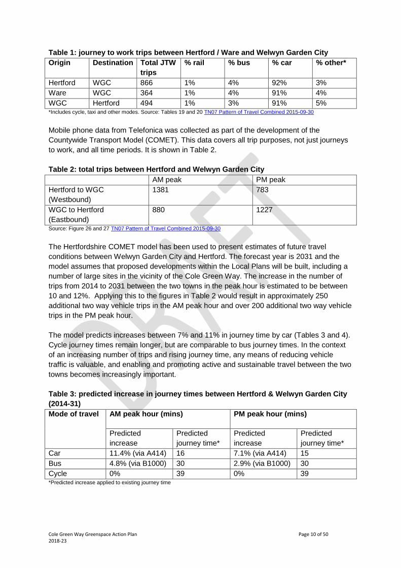
rush hours. Journey to work data taken from the 2011 census is shown in Table 1 and
shows that over 90% of usual work journeys between the towns are taken by car.
Cole Green Way Greenspace Action Plan Page 10 of 502018-23
Table 1: journey to work trips between Hertford / Ware and Welwyn Garden City
Origin Destination Total JTW
trips
% rail % bus % car % other*
Hertford WGC 866 1% 4% 92% 3%
Ware WGC 364 1% 4% 91% 4%
WGC Hertford 494 1% 3% 91% 5%*Includes cycle, taxi and other modes. Source: Tables 19 and 20 TN07 Pattern of Travel Combined 2015-09-30
Mobile phone data from Telefonica was collected as part of the development of the
Countywide Transport Model (COMET). This data covers all trip purposes, not just journeys
to work, and all time periods. It is shown in Table 2.
Table 2: total trips between Hertford and Welwyn Garden City
AM peak PM peak
Hertford to WGC
(Westbound)
1381 783
WGC to Hertford
(Eastbound)
880 1227
Source: Figure 26 and 27 TN07 Pattern of Travel Combined 2015-09-30
The Hertfordshire COMET model has been used to present estimates of future travel
conditions between Welwyn Garden City and Hertford. The forecast year is 2031 and the
model assumes that proposed developments within the Local Plans will be built, including a
number of large sites in the vicinity of the Cole Green Way. The increase in the number of
trips from 2014 to 2031 between the two towns in the peak hour is estimated to be between
10 and 12%. Applying this to the figures in Table 2 would result in approximately 250
additional two way vehicle trips in the AM peak hour and over 200 additional two way vehicle
trips in the PM peak hour.
The model predicts increases between 7% and 11% in journey time by car (Tables 3 and 4).
Cycle journey times remain longer, but are comparable to bus journey times. In the context
of an increasing number of trips and rising journey time, any means of reducing vehicle
traffic is valuable, and enabling and promoting active and sustainable travel between the two
towns becomes increasingly important.
Table 3: predicted increase in journey times between Hertford & Welwyn Garden City
(2014-31)
Mode of travel AM peak hour (mins) PM peak hour (mins)
Predicted
increase
Predicted
journey time*
Predicted
increase
Predicted
journey time*
Car 11.4% (via A414) 16 7.1% (via A414) 15
Bus 4.8% (via B1000) 30 2.9% (via B1000) 30
Cycle 0% 39 0% 39*Predicted increase applied to existing journey time

Cole Green Way Greenspace Action Plan Page 11 of 502018-23
Table 4 – predicted increase in journey times between Welwyn Garden City & Hertford
(2014-31)
Mode of travel AM peak hour (mins) PM peak hour (mins)
Predicted
increase
Predicted
journey time*
Predicted
increase
Predicted
journey time*
Car 7.2% (via A414) 15 6.5% (via A414) 16
Bus 5.5% (via B1000) 31 2.5% (via B1000) 27
Cycle 0% 33 0% 33*Predicted increase applied to existing journey time
2.5.2 Transport and health
The Hertfordshire Health and Wellbeing Strategy 2016-2020 includes an objective to: ‘seek
to increase the proportion of working age adults who are getting the recommended level of
physical activity and reduce levels of overweight and obesity.’ The recommendation for
adults is 150 minutes of moderate physical activity per week, but currently one in four adults
across Hertfordshire do less than 30 minutes moderate activity a week. Growth in active
travel and recreation will increase levels of physical activity, thereby improving health,
promoting mental wellbeing, improving quality of life and helping promote independence.
Public health provides a strong business case for investing in cycling and walking, which
offer excellent value for money, including by preventing the cost of ill health to society and
the public purse. It is estimated that overweight and obesity cost the county £404m per year
(Health and Wellbeing Strategy 2013-16). For more information see a briefing on the health
benefits of physical activity and active travel.
2.5.3 Air quality and climate change
Emissions from transport are a major source of air pollution, and poor air quality is also a
serious threat to health. In Hertfordshire, 514 deaths per year are thought to be attributable
to fine particulate air pollution (Public Health England). Any modal shift from car to active
travel will provide additional health and environmental benefits by reducing air pollution.
Increased use of the Cole Green Way offers particular potential to improve air quality.
Gascoyne Way in Hertford is one of 30 Air Quality Management Areas in Hertfordshire,
where national standards of air quality are not being met in relation to nitrogen dioxide.
Improvements to the Cole Green Way are noted as action RE11 in the East Herts Air Quality
Action Plan 2017/18 – 2019/20.
Reducing greenhouse gas emissions from transport is also essential if national targets are to
be met. Road use by each Hertfordshire resident produces 2.3 tonnes of carbon dioxide per
year, 6% higher than the East of England average (National Statistics, 2017).
2.5.4 Development proposals
The Cole Green Way will be a critical piece of strategic green infrastructure for
developments proposed in the emerging local plans for Welwyn Hatfield and East Herts,

Cole Green Way Greenspace Action Plan Page 12 of 502018-23
providing both an important link for active travel and a valuable resource for recreation and
biodiversity. Both plans are currently at the stage of independent examination by a
government planning inspector. Once agreed, the East Herts District Plan will cover the
period until 2033, and the Welwyn Hatfield Local Plan will operate until 2032. The most
significant potential development is Birchall Garden Suburb, which would have over 2500
homes both to the north and the south of the Cole Green Way.
2.6 GEOGRAPHY, LANDSCAPE & DESIGNATIONS
The entirety of the Cole Green Way lies within the Green Belt. It passes through the
Hertingfordbury Conservation Area and reaches the edge of the Hertford Conservation Area.
The HCC-owned section of the route is a Local Wildlife Site (58/006) and the route passes a
number of additional Local Wildlife Sites, shown on the constraints maps in 2.3:
Rolls and Blackthorn Woods (58/020 – ancient woodland)
Greater Captain’s and Howellpark Wood (58/015 – ancient woodland)
Cowper Arms Pit (58/011 – protected species)
Hazeldene Area, East Green (58/033 – protected species)
Meadow and River Lee by Leahoe Viaduct North-west (59/011 – grassland)
The route lies largely within the Cole Green and Hertingfordbury Settled Farmland
Landscape Character Area (LCA), reaching the Welwyn Fringes LCA in the west. This is a
mainly pastoral area of small, long-established hamlets, notably Cole Green, Letty Green,
Birch Green and Hertingfordbury. The urban influence of the larger towns of Welwyn Garden
City and Hertford is only apparent at the western and eastern fringes of this area. Despite
the presence of the A414 to the north, most of the area feels remote and tranquil.
As a wooded green corridor, the Cole Green Way is a significant feature traversing the
landscape. Between Hertingfordbury and Letty Green it follows the valley of a tributary of the
River Mimram, and it passes through cuttings and along embankments throughout the HCC-
owned section. This provides sections with the potential for open views and sections which
are naturally more enclosed, but it is currently dull and gloomy along much of the route;
indeed it is described as a ‘sepulchral alleyway’ in the Landscape Character Assessment.
The section managed by Tarmac Ltd is much more open, passing across a recently-
disturbed landscape. While the Cole Green Way does follow the route of the former railway
line, there is no remaining evidence of that line in the landscape.
2.7 HISTORY & ARCHAEOLOGY
The Cole Green Way follows the route of the Hertford North to Welwyn Garden City branch
of the Great Northern Railway. This opened in 1858, operated passenger traffic until 1951
and closed to all railway traffic in 1962.
There are a number of historic features along the route. Primary among these is the former
Cole Green Station, which is owned by HCC. Cole Green Station opened on 1st March 1858
and at its peak had two platforms, both containing timber waiting rooms with wide canopies,

Cole Green Way Greenspace Action Plan Page 13 of 502018-23
and a two storey brick station building incorporating the booking office and stationmaster’s
house. As a passenger station it served the villages of Cole Green and Letty Green, while
also containing a goods yard, coal yard, and cattle dock and pens. The station was busy
enough to support an adjacent pub called the Railway Tavern which survives today as the
Cowper Arms. Following closure of the branch line in 1962, the station gradually fell into
disrepair with the surrounding land taken over by scrub and secondary woodland. A detailed
history of this station, and of the Hertford North to Welwyn Garden City line as a whole, can
be found here.
Despite the passage of time, the station is still readily identifiable as such. Both platforms
have survived, with some original cast iron railings at the rear of each. Part of the northern
platform and the former station forecourt are used as a car park, and the goods yard is used
as a picnic area. The southern platform is now heavily overgrown with some brickwork from
the platform buildings remaining.
Figure 1. Map of Cole Green station from 1898 overlaid with modern site description.
At Hertingfordbury Station, the single platform and station building survive. The station
building has been heavily modified, and both this and the platform are now in private
ownership.
Former railway bridges carry the route over roads at St Marys Lane (Hertingfordbury Station
Railway Bridge), Birch Green (Birch Green Railway Bridge) and Station Road (Letty Green
Bridge). A former bridge at Staines Green has been filled in, and this is the only point at
which the Cole Green Way now crosses a road. The only historic bridge which crosses the

Cole Green Way Greenspace Action Plan Page 14 of 502018-23
Cole Green Way is Hertingfordbury Park Bridge, close to St. Joseph’s in the Park School,
which is disused and overgrown, but still a prominent feature on the route.
Figure 2. Hertingfordbury Park Bridge and Cole Green Station.
2.8 HABITATS & WILDLIFE
2.8.1 Habitats
The banks adjoining the old railway line have been naturally colonised by secondary
woodland and scrub since the closure of the railway and the cessation of regular, large scale
vegetation clearance. This now provides an important continuous linear wildlife corridor.
Tree and scrub species along the banks include oak, ash, sycamore, hawthorn, blackthorn
and field maple. There is some evidence of old hedgerows which have now developed into
mature scrub, for example close to the eastern end. Ash is particularly prominent towards
the eastern end, and it is likely that this area will be affected by Chalara dieback of ash
within the next decade.
In many places, the dense semi-mature woodland on the embankments and cuttings
prevents light from reaching the floor, and results in a poor, shade tolerant ground flora.
Narrow strips of grasses and wild flowers border the central track where sufficient light
reaches the ground. In a few places there are larger, more open areas of diverse grassland
with species such as cowslip, common bird’s-foot-trefoil, common knapweed and field
scabious. The Cole Green Way from Hertford to the A414 is a Local Wildlife Site as a result
of this grassland habitat.
Figure 3. Wooded and more open sections of the Cole Green Way, close to the Hertford end and close to the A414.

Cole Green Way Greenspace Action Plan Page 15 of 502018-23
2.8.2 Species
A HERC data search obtained shows that several protected species have been recorded
close to the Cole Green Way. However, few records are directly associated with the site.
Great crested newt has been recorded from three 1km squares crossed by the Cole Green
Way around Cole Green Station. Reptiles include slow worm, adder and grass snake.
Badgers have been recorded in numerous locations along the route and there may be setts
in the embankments or cuttings. Bats will also use the Cole Green Way as a corridor to feed
along, and mature trees have the potential to hold roosting bats. A variety of common birds
can be expected to nest in trees and scrub along the route.
The invertebrate fauna is also diverse, and includes a variety of common butterflies and a
colony of glow worms, which can be found close to Cole Green Station.
2.9 ACCESS, FACILITIES & INFRASTRUCTURE
2.9.1 Access, circulation and entrances
The Cole Green Way is not a designated Public Right of Way, but access is permitted for
walkers, cyclists and horse riders. It forms part of Sustrans National Cycle Network Route 61
between St Albans and Hoddesdon, providing an off-road link between Welwyn Garden City
and Hertford. At the Welwyn end it connects directly to the road network via Cole Green
Lane, and at the Hertford end there is a further short off-road section along Hertford
Footpath 055 then Hertford Byway 054 before the route reaches the road at West Street.
It is accessible from all the roads and rights of way which cross or meet the route:
Cole Green Lane
Hertingfordbury Footpath 014 towards Birchall Lane and A414
Hertingfordbury Footpath 028 towards A414
Hertingfordbury Bridleway 027 towards The Old Coach Road
Station Road (Cole Green Station)
Hertingfordbury Footpath 009 towards The Old Coach Road and Chapel Lane
Hertingfordbury Footpath 007 towards Birch Green and Chapel Lane
Birch Green
Hertingfordbury Footpath 004 towards Birch Green and Staines Green
Staines Green
St Mary’s Lane
Hertford Byway 056 towards St Mary’s Lane and West Street
Hertford Footpath 055 towards St Mary’s Lane and West Street
The Cole Green Way passes over old railway bridges at three of its four road crossings. At
Staines Green, the bridge has been lost and the route crosses the road, which is very quiet
and does not pose a significant danger to users of the Cole Green Way.

Cole Green Way Greenspace Action Plan Page 16 of 502018-23
2.9.2 Car parks and vehicular access
There are two car parks. The main car park on the platform of the former Cole Green Station
has space for around 8 vehicles. There is also space for three vehicles at St Mary’s Lane.
No motor vehicles are allowed on the Cole Green Way apart from contractors authorised by
the landowners. The main access for authorised vehicles to the HCC-owned section of the
Cole Green Way is at Cole Green Station, and the route can also be accessed from Staines
Green.
2.9.3 Path surface
The HCC-owned section of the route has an unbound or semi-bound aggregate surface,
which in many places is covered by organic material and can be very wet during the winter.
The wetter and muddier sections are generally associated with the cuttings, which are
darker, shadier and have more overhanging vegetation. The section between the Hertford
end and St Mary’s Lane is a good example of this. In contrast, the embankments are usually
lighter and drier. Two short sections close to the A414 have been resurfaced recently, and
the surface here is much less smooth, with large stones on the surface.
At the western end of HCC ownership, the route passes through an underpass under the
A414 which regularly floods in the winter. This and the section west of the A414 are surfaced
with tarmac.
2.9.4 Destinations accessible from the Cole Green Way
The primary destinations of the Cole Green Way are Welwyn Garden City and Hertford,
towns with populations of 48,000 and 26,000 respectively (2011 census) and major
employers such as Tesco and Hertfordshire County Council. The neighbouring settlements
of Hatfield (39,000) and Ware (19,000) can also be accessed by a combination of on- and
off-road routes. The nearest railway stations are Welwyn Garden City (two miles), Hertford
East (one mile) and Hertford North (one and a half miles).
The route also provides access to all the villages between Welwyn Garden City and
Hertford, including Cole Green, Letty Green, Birch Green and Hertingfordbury. The old Cole
Green Station, with a picnic area, a small woodland and the Cowper Arms nearby, is a
potentially popular but underutilised stopping point.
The primary recreational destination in the area is Panshanger Park. Two public footpaths
cross the A414, providing the potential for circular walks incorporating the Cole Green Way
and the network of permissive routes which cross the park. Woodland walks closer to the
Cole Green Way are possible at Maitland Wood, Greater Captain’s Wood and Rolls &
Blackthorn Woods. Hertford Town Football Club are based at the eastern end of the route.
There are a number of new developments planned in both Welwyn Garden City and
Hertford. The most significant of these in terms of size and impact on the Cole Green Way is
the development referred to as Birchall Garden Suburb, which would create over 2500 new
homes on either side of the section of the Cole Green Way managed by Tarmac Ltd. A new

Cole Green Way Greenspace Action Plan Page 17 of 502018-23
retirement community is proposed, subject to planning permission, for a former brickfields
site near the viaduct and adjacent to the Cole Green Way. This would become another
destination served by the route.
Figure 4. Destinations accessible from the Cole Green Way.
2.9.5 Furniture
There are six benches or seats along the route, along with several more around Cole Green
Station, where there are also picnic tables and two carved seats. There is a height barrier at
the entrance to Cole Green Station from Station Road, and a vehicle gate providing access
to the picnic area and the Cole Green Way. There is also a vehicle gate at the Hertford end
of the route, just west of the viaduct.
Ramps provide access to the Cole Green Way at each of the road crossing points. At some
points, for example St Mary’s Lane, these have shallow steps. At most access points from
rights of way there is either no access furniture or disused access furniture with a gap next to
it. The exceptions are steps which are used to access Hertford Byway 056 and
Hertingfordbury Footpath 004.
2.9.6 Signage, interpretation and leaflets
There are various fingerposts along the route – blue cycle route signs for the National Cycle
Network and connecting routes, Rights of Way signs and some additional routed wooden
signage. National Cycle Network route 61 is also signed in places with small blue markers
on fence posts.

Cole Green Way Greenspace Action Plan Page 18 of 502018-23
The main entrance points, at Cole Green Station, St Mary’s Lane and the Hertford end of the
route have large wooden ‘Cole Green Way’ entrance signs. At all entrance points in the
HCC-owned section there are small badges on posts labelling the route as the Cole Green
Way.
Historical interpretation boards are located at both ends of the Cole Green Way and at Cole
Green Station, where a wind-up interpretation panel is now broken.
A Cole Green Way leaflet was produced in 2005. This details the whole route, its history,
what to see and do along the route and contact details for the organisations involved with the
route. The Cole Green Way is also included on the Hertfordshire Cycling Map for Recreation
and Commuting.
2.9.7 Structures
There are six structures along the HCC-owned section of the Cole Green Way:
A414 underpass – carries the Cole Green Way, owned by HCC
Letty Green Bridge – carries the Cole Green Way, owned by HCC
Birch Green Bridge – carries the Cole Green Way, owned by HCC
St Mary’s Lane Bridge – carries the Cole Green Way, owned by HCC
Hertingfordbury Park Bridge – disused, owned by HCC
Hertford Viaduct – carries the mainline railway, owned by Network Rail
2.10 COMMUNITY, MANAGEMENT & EVENTS
The Cole Green Way has two landowners. The 4.4km section between the railway viaduct
close to Hertford Town Football Club and the A414 is owned and managed by HCC, and has
been used for active travel and recreation since the closure of the Hertford to Welwyn
Garden City railway in 1962.
The remaining 1.8km from the A414 to the edge of Welwyn Garden City at Cole Green Lane
is owned by Birchall Gardens LLP and managed by Tarmac Ltd. Vegetation management
along this section is carried out by HCC’s Rights of Way team, which does not currently
receive regular funding for this work. At the Hertford end, a 400m off road route links to West
Street, along a Byway Open to All Traffic. This section is largely in private ownership.
The route is split between East Hertfordshire and Welwyn Hatfield districts, and between
three town or parish councils: Hertford, Hertingfordbury and Essendon.

Cole Green Way Greenspace Action Plan Page 19 of 502018-23

Cole Green Way Greenspace Action Plan Page 20 of 502018-23
This is the first five year Greenspace Action Plan to be produced for the route, and has been
produced in consultation with relevant stakeholders, including:
British Driving Society
British Horse Society
Cycle Herts
East Herts Council
Essendon Parish Council
Hertford Town Council
Hertfordshire County Council
Hertfordshire & Middlesex Wildlife Trust
Hertingfordbury Parish Council
Ramblers Association
Sustrans
Tarmac Ltd
Welwyn Hatfield Borough Council
Neighbouring landowners and the local community
The Cole Green Way is a popular route, used by various user groups – for walking, running,
cycling and horse riding. To date there has only been small scale volunteer involvement in
its management, including very occasional tasks by practical conservation volunteers and
litter picking organised by local parish councils. No regular events are currently held on the
route.
Cole Green Way Greenspace Action Plan Page 21 of 502018-23
3. ANALYSIS AND EVALUATION
3.1 A FUNCTIONAL MULTI-USER ROUTE
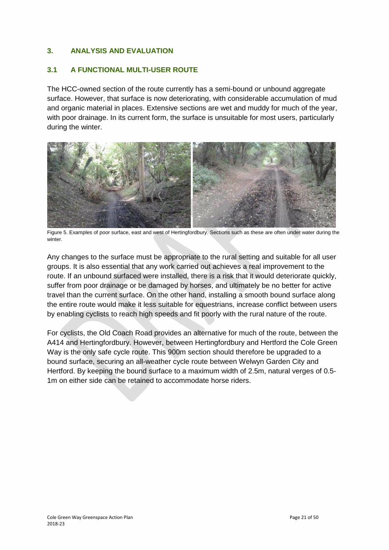
The HCC-owned section of the route currently has a semi-bound or unbound aggregate
surface. However, that surface is now deteriorating, with considerable accumulation of mud
and organic material in places. Extensive sections are wet and muddy for much of the year,
with poor drainage. In its current form, the surface is unsuitable for most users, particularly
during the winter.
Figure 5. Examples of poor surface, east and west of Hertingfordbury. Sections such as these are often under water during the
winter.
Any changes to the surface must be appropriate to the rural setting and suitable for all user
groups. It is also essential that any work carried out achieves a real improvement to the
route. If an unbound surfaced were installed, there is a risk that it would deteriorate quickly,
suffer from poor drainage or be damaged by horses, and ultimately be no better for active
travel than the current surface. On the other hand, installing a smooth bound surface along
the entire route would make it less suitable for equestrians, increase conflict between users
by enabling cyclists to reach high speeds and fit poorly with the rural nature of the route.
For cyclists, the Old Coach Road provides an alternative for much of the route, between the
A414 and Hertingfordbury. However, between Hertingfordbury and Hertford the Cole Green
Way is the only safe cycle route. This 900m section should therefore be upgraded to a
bound surface, securing an all-weather cycle route between Welwyn Garden City and
Hertford. By keeping the bound surface to a maximum width of 2.5m, natural verges of 0.5-
1m on either side can be retained to accommodate horse riders.

Cole Green Way Greenspace Action Plan Page 22 of 502018-23
Figure 6. Alternative all-weather route from A414 to Hertingfordbury via the Old Coach Road.
The remaining 3500m of the route should also be improved, by establishing a camber and
improving drainage, but a bound surface will not be installed. Here the preferred option
would be a durable self-binding surface which is not susceptible to damage by horses, with a
width of 2m. This combination of treatments is the best available balance between the needs
of the various user groups and should maintain the rural character of the Cole Green Way. A
complementary package of measures to improve the experience for cyclists along the Old
Coach Road should be implemented by the County Council.
Specific surface treatments along both sections should be chosen for maximum durability,
minimising long-term maintenance costs. Nevertheless, good maintenance will be essential
to maximise the lifespan and functionality of the surfaces – the surface should be inspected
annually and any problems addressed.
The section of the route managed by Tarmac Ltd has a relatively new tarmac surface with a
width of 2m along its length. A lack of grounds maintenance here causes tall vegetation to
fold over in places, reducing its functional width during the summer and making collisions
between users more likely. Cutting of the verges should take place regularly along this
section of the route throughout the spring, summer and autumn.

Cole Green Way Greenspace Action Plan Page 23 of 502018-23
Figure 7. The section managed by Tarmac Ltd is generally more open, but its width is reduced in places by tall vegetation.
As this section of the Cole Green Way is not constrained by the width of the former railway
cuttings and embankments, it would be desirable to widen the tarmac surface to the
optimum of at least 3m along its full length to allow for safe and functional shared use. This
will be particularly important in the context of the proposed Birchall Garden Suburb
development, which is likely to increase use of this section of the route considerably.
Improvements to drainage are required along the entirety of the HCC-owned section of the
route, and should be established in parallel with surfacing improvements. As the vast
majority of the route is straight and flat, the new surface should generally be constructed with
a minimum camber of 1:40 to ensure that it sheds water laterally. On any slopes, a cross fall
of a similar gradient may be appropriate, and on bends the path should always fall from the
outer edge to the inside. Where possible, the path should be constructed in a way that
ensures it is higher than the immediately adjacent ground on both sides, to prevent water
sitting on the path.
The main drainage structures should be French drains on both sides of the path. These are
trenches filled with stones which intercept surface water flows from either side of the path
and collect surface water from the path. As the Cole Green Way is largely flat, surface water
cannot easily run away, but can be encouraged to percolate gradually into the ground, rather
than running over or sitting on the surface. All drainage structures installed will require
regular routine maintenance in order to function effectively. This routine maintenance should
include an existing drain at the west end of the A414 underpass, which requires frequent
clearing to minimise the risk of flooding here.
Signage on the Cole Green Way and at its access points is currently sparse and provides
inconsistent and inaccurate distance measurements. Existing signage should be replaced
with new cycle route signage carrying a new Cole Green Way logo, and a sign should be
located on the Cole Green Way and at the start of the access route at every road junction.
These signs will generally show distances to two destinations, either Welwyn Garden City or
Hertford and the closest minor destination. Where appropriate, signs should also indicate
destinations which can be reached from the Cole Green Way, such as the Old Coach Road
and Panshanger Park. There should also be signage for public rights of way at each junction
with a right of way, showing destinations and distances.

Cole Green Way Greenspace Action Plan Page 24 of 502018-23
Figure 8. Inconsistent and misspelled National Cycle Network signage at the A414 and Staines Green.
It is equally important that the Cole Green Way is appropriately signed from off site,
particularly at the destinations identified in 2.9.4, and that any signage that includes the Cole
Green Way has the same branding. Wherever possible this should be achieved using
stickers rather than by replacing signs.
The access points to the Cole Green Way require updating to ensure all are fit for purpose
and provide easy and welcoming access for all users. In this and all other aspects, the route
should meet the standard set out by the Fieldfare Trust to enable access to the countryside
for disabled people. As noted in 3.5, the standard access furniture should be bollards,
removable where necessary, to prevent vehicular access. The several low wooden steps
across many of the entrances from roads should be removed and replaced with an even
slope, aiming for a maximum gradient of 10%. Wherever a slope exceeds 5%, it should also
include a level resting point for every 950mm of ascent. Any unnecessary access furniture
should be removed, including at public footpath crossing points where there are several
disused pieces of access furniture.
Access onto the Cole Green Way at the Hertford end is particularly difficult. A narrow and
uneven path links the beginning of the Cole Green Way to the car park of Hertford Town
Football Club. Improvements to the surface of this path should be sought in collaboration
with the landowners, recognising the importance of this route for equestrians and aiming to
achieve a split surface with parallel bound and unbound sections. This solution would require
additional width to be dedicated to the footpath.

Cole Green Way Greenspace Action Plan Page 25 of 502018-23
The car park is heavily potholed, with a smoother tarmac surface along the edge where
Hertford Byway 056 runs. This smoother section is often blocked by parked cars, forcing
cyclists to use the potholed section. A means of minimising parking on the byway section of
the car park should be developed, such as markings painted on the byway.
Figure 9. Entrance to the Cole Green Way at Hertingfordbury and Hertford Byway 056 approaching the Cole Green Way.
Regular routine maintenance of the route is important to ensure that it feels cared for and to
encourage regular use. This should include promptly removing any graffiti or fly tipping when
it is reported, carrying out regular litter picking particularly around Cole Green Station and
small scale vegetation management. The regular programme of vegetation cutting along the
margins of the HCC-owned section of the route should continue, to keep the full width of the
path and access points, as well as signage and furniture, free from encroaching vegetation
throughout the year. A path corridor which is at least 4m high and extends 1m to either side
of the track should be kept free of vegetation. Between Hertingfordbury and Hertford, the
accumulation of organic debris on the new bound surface should be prevented by annual
sweeping.
An issue with bagged dog waste has been identified at Cole Green Station. The County
Council are not able to take on the cost of emptying a dog bin here. The absence of a bin is
not an excuse to leave dog waste behind; it should be taken home as with any other form of
litter. A small notice should be included on interpretation boards encouraging visitors to do
this, like this example from Bencroft Wood.
Figure 10. Extract from interpretation board at Bencroft Wood.

Cole Green Way Greenspace Action Plan Page 26 of 502018-23

Cole Green Way Greenspace Action Plan Page 27 of 502018-23
3.2 USER EXPERIENCE & PROMOTION
The current user experience of the Cole Green Way is of a route which is functional and
attractive in places, but somewhat neglected. This feeling will be addressed to some extent
by improvements to the route itself described in 3.1 and by the woodland management
proposed in 3.5. The experience of users can be further enhanced by replacing furniture and
upgrading interpretation.
A starting point in better promoting the Cole Green Way would be to build its identity. This
could include a logo based on its railway heritage, similar to that already developed for the
Alban Way. The logo would be used on all signage, both on- and off-route, to make it very
clear to users when they are heading towards or following the Cole Green Way and develop
a recognisable and consistent image for all sections of the route, whether managed by HCC
or Tarmac Ltd. New attractive and welcoming signage should be installed at the main
entrances to replace existing signage, at the Hertford end, St Mary’s Lane and Cole Green
Station. At the Hertford end, the entrance sign should be moved to the edge of Hertford
Town FC car park, alongside the interpretation board, to greatly increase its visibility. An
additional entrance sign should also be installed at Cole Green Lane.
Figure 11. Entrance sign at the Hertford end of the Cole Green Way and branded cycle route signage on the Alban Way.
The existing leaflet for the Cole Green Way should be reviewed and updated with new
information on links and destinations, as well as the alternative route along the Old Coach
Road. It should be distributed as widely as possible, including to standard outlets like tourist
offices and libraries, as well as significant employers in Welwyn Garden City and Hertford.
The leaflet and other information about the Cole Green Way should also be made widely
available digitally, through sources such as the Hertfordshire County Council website and
the Parks Herts website. The Cole Green Way should also be promoted in the media and
through social media, particularly as the improvements associated with this plan are
implemented and celebrated.
Other than the two ends, the main entry point to the Cole Green Way is Cole Green Station.
This is currently a low key site, with a parking and picnic area in poor condition. Establishing
it as a recreational destination in its own right, in particular through the major heritage project
proposed in 3.4, would create an entirely new group of potential recreational users and help
improve local awareness of the Cole Green Way as a whole.

Cole Green Way Greenspace Action Plan Page 28 of 502018-23
There are wooden benches, seats and picnic tables spread widely along the route. These
are generally ageing and those around Cole Green Station are in particular need of
replacement. New furniture should be installed here following a consistent style, ideally as
part of the heritage project described in 3.4. New furniture should also be installed along the
route to provide a resting point every 300m. Existing benches and seats along the route
should be replaced in the same style when they come to the end of their functional life.
The three interpretation boards are also ageing, and the version at Cole Green Station has a
moving part which is broken. These should be updated with attractive new boards of a
customised design, perhaps similar to those recently installed on the Alban Way.
Interpretation should be retained in its current locations at each end of the route and at Cole
Green Station. These boards help new visitors understand the route and particularly its
historical significance.
Figure 12. Interpretation boards at Cole Green Station and on the Alban Way.
The small woodland at Cole Green Station should also be better promoted. While it contains
a number of informal paths, a clear circular route could be established with simple
waymarking from the car park to advertise it as a publicly accessible area.
It is vital that user numbers are monitored, before the start of any work, as it takes place and
in the years afterwards. This will provide valuable information on the impact both of the work
itself and of additional promotion of the route, informing future investment in similar
schemes.

Cole Green Way Greenspace Action Plan Page 29 of 502018-23
Cole Green Way Greenspace Action Plan Page 30 of 502018-23
3.3 FUNDING, IMPLEMENTATION & FINANCIAL SUSTAINABILITY
The actions set out in this plan are largely subject to external funding. Securing this funding
is central to achieving the goals of the plan and should therefore be a primary early focus. It
is expected that the work will be carried out in sections, based on several rounds of bids to
external funding sources. These sources could include:
S106 funds currently available from developments in Welwyn Garden City and
Hertford.
Direct contributions through the S106 or Community Infrastructure Levy process from
future developments in Welwyn Garden City and Hertford.
Grant funding, for example Heritage Lottery Fund, for a heritage project focused on
Cole Green Station or for access improvements.
Any investment, particularly in surfacing and drainage along the route, should include
provision for future maintenance, to ensure that the County Council does not incur additional
maintenance costs as a result of the work. Maintenance costs should also be taken into
account when considering the most cost-effective and appropriate surface for the route.
Where feasible, the costs of vegetation management along the route should be offset by the
sale of timber. This will not be sufficient to make such works cost neutral, but should reduce
the total cost of the work. Pre-planning tree works in larger sections creates a more
commercially viable product.
Enabling volunteers to contribute to the management of the Cole Green Way wherever
possible, as described in 3.6, will reduce the cost implications of a number of the actions
proposed. Tasks which are well-suited to volunteers include scrub management, hedgerow
restoration, installation of signage and furniture, small-scale construction such as
replacement of steps, and litter picking.
Timings set out in the action plans in section 5 are indicative and may be brought forward or
set back depending on the availability of funding.
3.4 CONSERVATION & HERITAGE
After 40 years’ use as an amenity space, Cole Green Station is now in need of revitalisation.
Dense surrounding woodland and scrub has grown to enclose much of the site, obscuring
and damaging surviving features such as the platforms and sections of iron railing. Due to its
dark and shady character and visual disconnection from the adjacent road and pub, it has
become a frequent spot for anti-social behaviour including fly-tipping and graffiti. Site
infrastructure including signage, surfacing, height barrier, bollards and picnic tables are
either redundant, poorly sited, or in dilapidated condition. This combination of negative
factors, partnered with a fundamentally flawed car park design which allows cars to park
hard up to the edge of the platform, has greatly reduced any sense of understanding or
potential for imagination that people can expect to feel when visiting a former railway station.

Cole Green Way Greenspace Action Plan Page 31 of 502018-23
Figure 13. Entrance to Cole Green Station and car park on the platform.
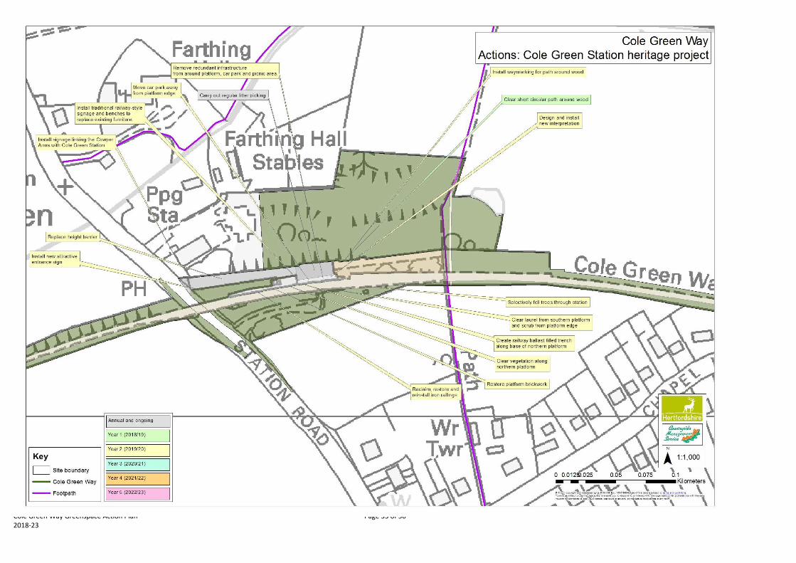
A project was developed in 2014 to restore the area around the station for both its heritage
and its recreational value, developing it as a key destination and entry point to the route for
cyclists and walkers. Initial discussions were held with the Heritage Lottery Fund, but no
grant application was submitted at that time. This project should now be reconsidered,
perhaps incorporating improvements to the Cole Green Way itself.
The project involved proposals to restore and improve the condition and setting of the
station’s northern platform in order to improve visitor experience and prevent further decline.
This would include relocating the car park back from the edge of the northern platform
alongside surface improvements and removal of redundant infrastructure. The platform
should be cleared of vegetation and a railway ballast-filled trench created along the front of
the wall to suppress further weed growth. Dense surrounding shrubs should be cut back,
focusing on laurel which grows along the southern platform, and trees selectively felled to re-
establish the light and open character of the former station and restore views for visitors. Iron
railings lost amongst the undergrowth should be reclaimed, restored and reinstalled as
boundary features and a place for visitors to lock up their bicycles. The southern platform
should be left with limited management such as removal of scrub from the platform edge
itself to help demonstrate reclamation by nature over time.
Figure 14. Trees growing from base of northern platform and iron railings within the scrub.
Local history groups and knowledgeable individuals could contribute to the recreation of
traditional benches and station signage to be installed along the restored platform, and
heritage enhancements of this kind could be used selectively along the whole of the Cole
Green Way. They would also be engaged to support the development of new interpretation
boards, both for the station and the remainder of the route. The existence of a good range of
historic photos of the station would also allow the development of digital interpretation based

Cole Green Way Greenspace Action Plan Page 32 of 502018-23
on the recreation of viewpoints using geo-referenced historic photos. The station’s links to
the community should also be strengthened, by restoring the visibility of links between the
site and the pub. A dedicated map showing actions around Cole Green Station can be found
in the action plan, section 5.
The primary conservation value of the Cole Green Way is as a wildlife corridor, and this
feature of the site should be maintained and enhanced. A proactive programme of rotational
woodland and vegetation management along the route would not only improve the user
experience and feeling of safety, but also contribute to the development and maintenance of
the secondary woodland and scrub habitats which predominate. Habitat management should
include glade creation and light thinning along the wooded sections, coppicing scrub where
this is the dominant habitat type, and restoring historic hedgerows where they are most
prominent. By maintaining or increasing light levels along the verges, this will also help
secure the floristically rich verges which prompted the designation of the Cole Green Way as
a Local Wildlife Site. Another priority is to prevent encroachment of trees and scrub onto the
route to maintain its functional width.
Woodland management is a higher priority at the eastern end of the route, particularly
between St Mary’s Lane and Hertford where the route is very dark and enclosed, and is not
required any further west than Cole Green Station. In contrast, coppicing scrub in order to
retain this valuable and attractive habitat and establish more open and sunny points along
the route is more important towards the western end, as little scrub remains east of Staines
Green.
All works carried out along the route should take into account the requirements of protected
and priority species, including bats, badgers and nesting birds. The colony of glow worms
around Cole Green Station is of particular interest. This should be surveyed in 2018 to
establish the extent and size of the colony and ensure that it is not disturbed by subsequent
work, with a follow-up survey scheduled to follow any work that does occur.
Non-native species are not especially prominent along the route. Those worthy of note and
which should be removed are several patches of laurel around Cole Green Station, and a
large Turkey oak close to the A414.
Cole Green Way Greenspace Action Plan Page 33 of 502018-23

Cole Green Way Greenspace Action Plan Page 34 of 502018-23
Cole Green Way Greenspace Action Plan Page 35 of 502018-23
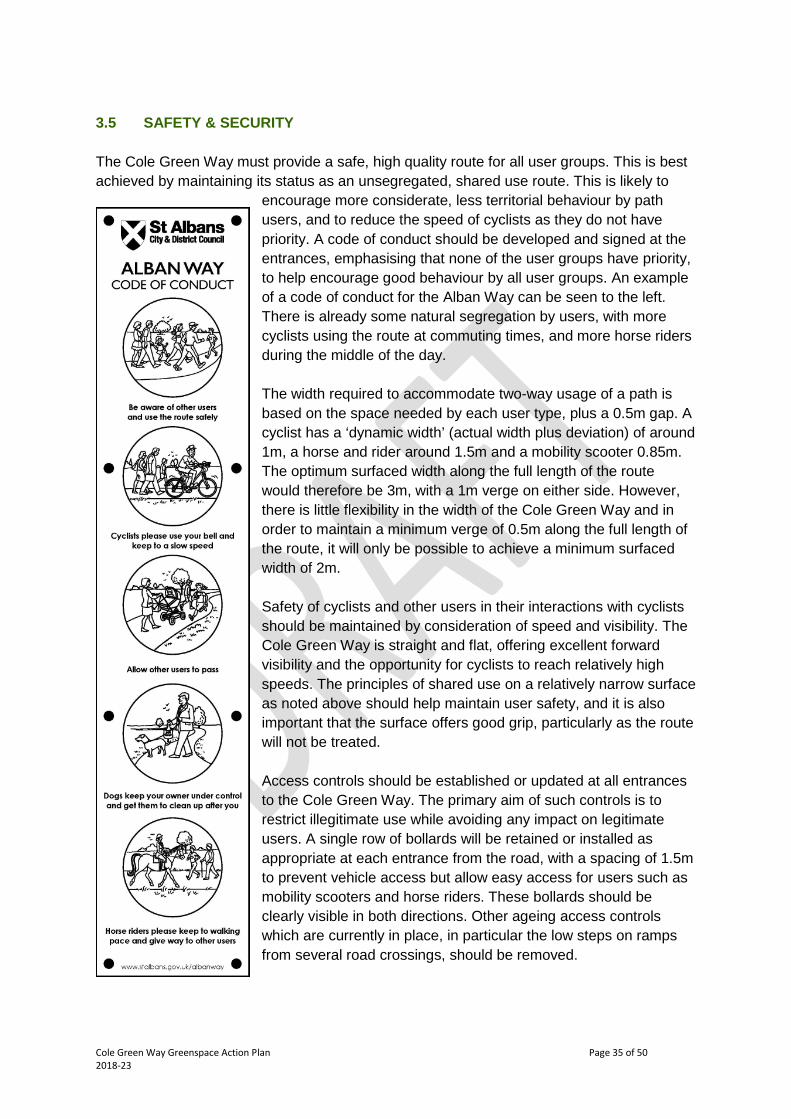
3.5 SAFETY & SECURITY
The Cole Green Way must provide a safe, high quality route for all user groups. This is best
achieved by maintaining its status as an unsegregated, shared use route. This is likely to
encourage more considerate, less territorial behaviour by path
users, and to reduce the speed of cyclists as they do not have
priority. A code of conduct should be developed and signed at the
entrances, emphasising that none of the user groups have priority,
to help encourage good behaviour by all user groups. An example
of a code of conduct for the Alban Way can be seen to the left.
There is already some natural segregation by users, with more
cyclists using the route at commuting times, and more horse riders
during the middle of the day.
The width required to accommodate two-way usage of a path is
based on the space needed by each user type, plus a 0.5m gap. A
cyclist has a ‘dynamic width’ (actual width plus deviation) of around
1m, a horse and rider around 1.5m and a mobility scooter 0.85m.
The optimum surfaced width along the full length of the route
would therefore be 3m, with a 1m verge on either side. However,
there is little flexibility in the width of the Cole Green Way and in
order to maintain a minimum verge of 0.5m along the full length of
the route, it will only be possible to achieve a minimum surfaced
width of 2m.
Safety of cyclists and other users in their interactions with cyclists
should be maintained by consideration of speed and visibility. The
Cole Green Way is straight and flat, offering excellent forward
visibility and the opportunity for cyclists to reach relatively high
speeds. The principles of shared use on a relatively narrow surface
as noted above should help maintain user safety, and it is also
important that the surface offers good grip, particularly as the route
will not be treated.
Access controls should be established or updated at all entrances
to the Cole Green Way. The primary aim of such controls is to
restrict illegitimate use while avoiding any impact on legitimate
users. A single row of bollards will be retained or installed as
appropriate at each entrance from the road, with a spacing of 1.5m
to prevent vehicle access but allow easy access for users such as
mobility scooters and horse riders. These bollards should be
clearly visible in both directions. Other ageing access controls
which are currently in place, in particular the low steps on ramps
from several road crossings, should be removed.

Cole Green Way Greenspace Action Plan Page 36 of 502018-23
Figure 15. Disused or unnecessary access controls close to Cole Green Station and at Cole Green Lane.
The Cole Green Way is not a public right of way and is not currently accessible to vehicles of
any kind. Given its importance for its existing users, both active travel and recreational,
whose requirements are the priority, it would not be appropriate to enable carriage drivers to
access the route. The restrictions on width noted above already have safety implications,
and these would only be exacerbated by allowing access to any form of vehicle.
It is very difficult to physically restrict motorbikes, which are no wider than legitimate users.
These should instead continue to be discouraged by signage and reported to the police
when observed. HCC does not have sufficient resources to regularly patrol the route, and
relies on the communities along the route to report any kind of misuse, either to the County
Council or to the police as appropriate.
Users can be given a greater feeling of security using high quality signage which provides
clear information on distances to entry and exit points, giving users confidence that they
would be able to leave the route in an emergency. Such signs should be placed on the main
route at all entrances from roads, signposting the next exit point in each direction, as well as
the main end points (Hertford and Welwyn Garden City).
A key point where some users may feel unsafe is the underpass under the A414. The
perception of the underpass could be improved by using it as a space for public art, in
conjunction with the potential new development to the west.
The Cole Green Way has become heavily shaded by overhanging trees, particularly where it
sits within former railway cuttings, and long sections are dark and shady. This causes the
route to feel enclosed, which can make users feel less safe and restrict potential views
across attractive open countryside. This is especially the case in the evenings and during the
winter months. However, it is a rural route, and the addition of any form of lighting would
detract from its character and have detrimental effects on some of its wildlife, for example
bats and glow worms. Lighting would also be expensive to install and maintain.
Carrying out vegetation and woodland management along the route will allow more light into
the path and create a more welcoming environment. This work will include glade creation
and thinning, to aid the development of the secondary woodland habitat, create pockets of
light for users to travel between and establish occasional viewpoints along the route. It would
be focused on the darker and more enclosed sections, particularly that between Hertford and
Hertingfordbury.
Cole Green Way Greenspace Action Plan Page 37 of 502018-23
The Cole Green Way is zoned as a medium risk area for tree safety by the County Council’s
Rural Estates team. Formal tree safety surveys are currently being carried out in high risk
areas, and whilst these are in progress no surveys are planned for medium risk areas. A six
monthly visual check of trees is carried out alongside other works, with a focus on potential
deterioration in ash trees. Reactive tree works are undertaken whenever a safety issue is
identified.
3.6 COMMUNITY INVOLVEMENT
Greater involvement of the local community in the management of the Cole Green Way has
started through the process of developing this plan. Two stages of community engagement
will enable stakeholders and local people to shape and influence the outcomes of the plan,
and should help build understanding and support for its objectives.
No formal Friends Group for the Cole Green Way is planned. Local practical conservation
volunteers should be engaged to work along the route where management objectives can be
achieved, for example to coppice shrubs and small trees or to install signage. There is a
particular interest in the local community in the heritage of Cole Green Station and the wider
route, and the potential to engage knowledgeable and enthusiastic people in the
development and implementation of the heritage project described in 3.4.
Local interest in the route should be further generated using Cole Green Station as a focal
point, particularly if a project to restore the heritage of the station goes ahead. Such a project
should include guided walks and talks both during the project and after its completion to give
people the opportunity to learn about the station’s history in greater depth.
While the County Council controls the majority of the route, to maximise the impact of this
plan and ensure that the full length of the route is in positive management it is vital that
Tarmac Ltd and other private landowners are engaged. Tarmac Ltd are supportive of the
process and prepared to consider recommendations which emerge from this plan. The short
off-road section at the Hertford end of the route follows public rights of way, and therefore
engagement with the multiple private landowners here to implement any relevant
recommendations should be agreed through the Rights of Way team in the County Council.
Works identified in the action plan below for land outside the control of the County Council
are recommendations only.

Cole Green Way Greenspace Action Plan Page 38 of 502018-23
4. AIMS AND OBJECTIVES
4.1 To improve and maintain the Cole Green Way, as a core component of
Hertfordshire’s strategic non-motorised transport network.
1A Improve the surface of the route to enable use throughout the year by all user
groups.
1B Improve drainage along the route.
1C Provide access points which are welcoming and suitable for all users.
1D Install appropriate and attractive signage to, from, along and at the entrances to the
route.
1E Establish links to the wider green infrastructure network, businesses and schools,
residential areas, public transport, shops, local amenities and local green spaces.
1F Manage and maintain the surface, signage and drainage of the route.
1G Remove graffiti and fly-tipping.
1H Carry out regular litter picking and small scale vegetation management.
1I Maintain regular vegetation cutting along the margins of the route.
4.2 To increase use of the Cole Green Way for both active travel and recreation.
2A Develop and implement a promotional strategy to increase awareness and usage of
the route.
2B Improve the visitor experience by providing appropriate and relevant interpretation.
2C Replace seats, benches and picnic tables in a consistent style.
2D Update the Cole Green Way leaflet and distribute it widely.
2E Develop appropriate branding for the Cole Green Way to build a recognisable and
consistent image for all sections of the route.
2F Establish Cole Green Station as a recreational destination and entry point to the
route.
2G Monitor user numbers to assess the impact of any improvements made.
4.3 To ensure financial sustainability of all management operations on site.
3A Ensure ongoing maintenance costs remain financially sustainable.
3B Support improvements to the route and reduce future revenue cost liability by
securing external capital investment.
3C Offset vegetation management costs through production and sale of timber where
feasible.
4.4 To protect and enhance the natural environment and heritage of the Cole Green
Way.
4A Restore and celebrate the historic features associated with the former Hertford to
Welwyn Garden City branch line along the route.
4B Undertake proactive rotational woodland and vegetation management along the
route to secure the future of high quality habitats and strengthen the continuity of
vegetation.
4C Work to enhance key habitats and secure priority species found along the route.

Cole Green Way Greenspace Action Plan Page 39 of 502018-23
4.5 To ensure that users of the Cole Green Way feel safe and welcome at all times.
5A Ensure that the Cole Green Way provides a safe, high quality route for all user
groups.
5B Respond proactively to any misuse of the site.
5C Carry out reactive tree works to address safety issues.
5D Plan targeted tree works to improve sight lines, establish views and increase light
levels along the route.
4.6 To develop and maintain an informed, involved and enthusiastic local community.
6A Engage the local community as widely as possible through the GAP development
process to build understanding and support for the plan, enabling them to shape
and influence the outcomes.
6B Enable the local community to contribute to the management of the Cole Green
Way in a structured and supported way and ensure all involved operate towards
achievement of the objectives of the GAP.
6C Work with Tarmac Ltd and other private landowners to ensure that the full length of
the route is in positive management.

Cole Green Way Greenspace Action Plan Page 40 of 502018-23
5. ACTION PLANS
ANNUAL AND REGULAR ACTIONS
ActionObj.Ref
When Responsibility Funding Est. Cost Spec. Ref Status
Clear leaves and mud from around drain atwest end of underpass
1F Sep HCC Rural EstatesSitemaintenancebudget
Sweep the surface between St Mary’s Laneand Hertford to remove organic debris
1FAnnualfrom Y2
HCC Highways
Carry out an annual inspection of surface,drainage and signage and identify anymaintenance requirements
1F Annual HCC Rural EstatesSitemaintenancebudget
Remove any graffiti or fly tipping whenreported
1G Ongoing HCC Rural EstatesSitemaintenancebudget
Carry out small scale vegetation managementas required
1H Ongoing HCC Rural EstatesSitemaintenancebudget
Carry out regular litter picking around ColeGreen Station
1H Ongoing HCC Rural EstatesSitemaintenancebudget
Continue regular vegetation cutting alongverges between the A414 and WGC
1I/6CApr-Octfrom Y2
Tarmac Ltd/HCCRoW
Maintain regular vegetation cutting alongverges in HCC management
1I Ongoing HCC Rural EstatesSitemaintenancebudget
Promote the Cole Green Way using socialmedia and promotional events/press releases
2A OngoingHCC RuralEstates/CMS
Officer time
Maintain seats and benches along route andreplace if necessary
2C Ongoing HCC Rural EstatesSitemaintenancebudget

Cole Green Way Greenspace Action Plan Page 41 of 502018-23
Seek external funding to implement GAP 3B OngoingHCC RuralEstates/CMS
External
Maintain ‘no motor vehicle’ signage at allmain entrances
5A Ongoing HCC Rural EstatesSitemaintenancebudget
Carry out reactive tree works to address anysafety issues
5C Ongoing HCC Rural EstatesSitemaintenancebudget
Engage volunteers where appropriate inpractical conservation and heritage projects
6B OngoingHCC RuralEstates/CMS
Volunteers

Cole Green Way Greenspace Action Plan Page 42 of 502018-23
YEAR 1 (2018-19)
ActionObj.Ref
When Responsibility Funding Est. Cost Spec. Ref Status
At Hertingfordbury footpath 007, removedisused stile to N of route
1C Apr-Sep HCC RoW/CMS RoW budget
At Hertingfordbury footpath 009, removedisused stiles to N and S of route
1C Apr-Sep HCC RoW/CMS RoW budget
Replace steps leading to Hertingfordburyfootpath 009
1C Apr-Sep HCC RoW/CMS RoW budget
Remove all disused and broken woodensignage and access furniture
1D Apr-SepHCC RuralEstates/CMS
Volunteers
Establish regular vegetation cutting alongverges between the A414 and WGC
1I/6C AprTarmac Ltd/HCCRoW
Design a new logo for the Cole Green Way 2E Apr-SepHCC RuralEstates/CMS
External
Clear circular path around Cole Green Stationwood
2F Oct-FebHCC RuralEstates/CMS
Volunteers
Install a cycle monitoring device 2G AprHCC Highways/Tarmac Ltd
Clear vegetation to expose disused bridge Wof St Mary’s Lane
4A/4B Oct-FebHCC RuralEstates/CMS
External
Coppice scrub in widely-spaced 25m blocksbetween A414 and Station Road
4BAnnual,Oct-Feb
HCC RuralEstates/CMS
Volunteers
Carry out glade creation and thinning withinsecondary woodland between St Mary’s Laneand Hertford
4B/5D Oct-FebHCC RuralEstates/CMS
External
Clear encroaching trees and scrub (pointsbetween St Mary’s Lane and Hertford)
4B Oct-FebHCC RuralEstates/CMS
External
Carry out glow worm survey 4C Jul CMS/volunteers Officer time/
Install shared use signage at all mainentrances
5A Apr-SepHCC RuralEstates/CMS
External

Cole Green Way Greenspace Action Plan Page 43 of 502018-23
YEAR 2 (2019-20)
ActionObj.Ref
When Responsibility Funding Est. Cost Spec. Ref Status
Install a new 2.5m wide bound surfacebetween St Mary’s Lane and Hertford
1A Apr-SepHCC RuralEstates/CMS
External
Install a new 2m wide bound surface betweenthe Cole Green Way and Hertford Town FC
1A/6C Apr-Sep
Privatelandowners/HCC Rural Estates/HCC RoW
External
Install French drains on both sides of the pathbetween St Mary’s Lane and Hertford
1B Apr-SepHCC RuralEstates/CMS
External
At Cole Green Lane, replace all existing accessfurniture with bollards
1C/5A/6C
Apr-Sep Tarmac Ltd/CMS External
At Cole Green Lane, install a new attractiveentrance sign
1C Apr-Sep Tarmac Ltd/CMS External
At Station Road, install a new attractiveentrance sign next to the road
1C/4A Apr-SepHCC RuralEstates/CMS
External
At Station Road, replace the height barrier atthe entrance to the car park
1C/4A Apr-SepHCC RuralEstates/CMS
External
At St Mary’s Lane, install a new attractiveentrance sign next to the road
1C Apr-SepHCC RuralEstates/CMS
External
At St Mary’s Lane, resurface and regradeentrance ramp to bound surface
1C Apr-SepHCC RuralEstates/CMS
External
At St Mary’s Lane, resurface parking bays tobound surface
1C Apr-SepHCC RuralEstates/CMS
External
At St Mary’s Lane, install bollards at base ofaccess ramp
1C/5A Apr-SepHCC RuralEstates/CMS
External
At Hertford Town FC, install a new attractiveentrance sign
1C Apr-SepPrivatelandowners/CMS
External
Improve online provision of information onthe Cole Green Way
2A Apr-SepHCC RuralEstates/CMS
Officer time
Design and install new interpretation at ColeGreen Lane
2B Apr-Sep Tarmac Ltd/CMS External
Cole Green Way Greenspace Action Plan Page 44 of 502018-23
Design and install new interpretation at ColeGreen Station
2B/4A Apr-SepHCC RuralEstates/CMS
External
Design and install new interpretation atHertford Town FC
2B Apr-SepPrivatelandowners/CMS
External
Install additional seats at 300m spacing alongwhole route
2C Oct-FebHCC RuralEstates/CMS
External
Redesign and reprint the Cole Green Wayleaflet
2D Apr-SepHCC RuralEstates/CMS
External
Distribute site leaflet as widely as possible 2D Oct-MarHCC RuralEstates/CMS
Officer time
Install waymarking around Cole Green Stationwood
2F Apr-SepHCC RuralEstates/CMS
External
Move car park back from edge of platform atCole Green Station
4A Apr-SepHCC RuralEstates/CMS
External
Remove redundant infrastructure fromaround platform, car park and picnic area
4A Apr-SepHCC RuralEstates/CMS
External
Clear vegetation along northern platform 4A Oct-FebHCC RuralEstates/CMS
External
Create railway ballast-filled trench along baseof northern platform
4A Oct-FebHCC RuralEstates/CMS
External
Restore platform brickwork 4A Oct-FebHCC RuralEstates/CMS
External
Clear laurel from southern platform and scrubfrom platform edge
4A Oct-FebHCC RuralEstates/CMS
External
Selectively fell trees through station torestore open character and improve views
4A Oct-FebHCC RuralEstates/CMS
External
Reclaim, restore and reinstall iron railings 4A Oct-FebHCC RuralEstates/CMS
External
Install traditional railway-style benches andsignage along the platform to replace existingfurniture
4A/2C Oct-FebHCC RuralEstates/CMS
External
Install signage linking Cole Green Station and 4A Apr-Sep HCC Rural External

Cole Green Way Greenspace Action Plan Page 45 of 502018-23
the Cowper Arms Estates/CMS
Restore historic hedgerow W of Cole GreenStation
4B Oct-FebHCC RuralEstates/CMS
Volunteers
Clear encroaching trees and scrub (pointsbetween Station Road and Staines Green)
4B Oct-FebHCC RuralEstates/CMS
External
Clear encroaching trees and scrub (pointsbetween Staines Green and St Mary’s Lane)
4B Oct-FebHCC RuralEstates/CMS
External

Cole Green Way Greenspace Action Plan Page 46 of 502018-23
YEAR 3 (2020-21)
ActionObj.Ref
When Responsibility Funding Est. Cost Spec. Ref Status
Widen the tarmac surface between WGC andthe A414 from 2m to 3m
1A/6C Apr-Sep Tarmac Ltd
Install a new 2m wide self-binding surfacebetween Birch Green and Staines Green
1A Apr-SepHCC RuralEstates/CMS
External
Install a new 2m wide self-binding surfacebetween Staines Green and St Mary’s Lane
1A Apr-SepHCC RuralEstates/CMS
External
Install French drains on both sides of the pathbetween Birch Green and Staines Green
1B Apr-SepHCC RuralEstates/CMS
External
Install French drains on both sides of the pathbetween Staines Green and St Mary’s Lane
1B Apr-SepHCC RuralEstates/CMS
External
At Staines Green (E side), resurface andregrade entrance ramp to smooth surface
1C Apr-SepHCC RuralEstates/CMS
External
At Birch Green, resurface and regradeentrance ramp to smooth surface
1C Apr-SepHCC RuralEstates/CMS
External
At Birch Green, install bollards at entrancefrom road
1C/5A Apr-SepHCC RuralEstates/CMS
External
Paint markings to indicate Hertford byway056 through Hertford Town FC car park
1C/6C Apr-SepPrivatelandowners /HCCRoW
External
Restore historic hedgerows E of A414 4B Oct-FebHCC RuralEstates/CMS
Volunteers

Cole Green Way Greenspace Action Plan Page 47 of 502018-23
YEAR 4 (2021-22)
ActionObj.Ref
When Responsibility Funding Est. Cost Spec. Ref Status
Install a new 2m wide self-binding surfacebetween Station Road and Birch Green
1A Apr-SepHCC RuralEstates/CMS
External
Install French drains on both sides of the pathbetween Station Road and Birch Green
1B Apr-SepHCC RuralEstates/CMS
External
Replace steps leading to Hertford byway 056 1C Apr-SepHCC RuralEstates/CMS
Volunteers
Replace NCN signage at Cole Green Lane 1D/5A Apr-Sep Tarmac Ltd/CMS External
Install RoW signage with destination anddistance at Hertingfordbury footpath 014
1D/5A Apr-Sep HCC RoW/CMS External
Install RoW signage with destination anddistance at Hertingfordbury footpath 028
1D/5A Apr-Sep HCC RoW/CMS External
Apply stickers with Cole Green Way logo tooff-site NCN signage in WGC
1D Apr-Sep CMS External
Replace NCN signage at Hertingfordburybridleway 027 and add sign to ‘Hertford viaOld Coach Road’
1D/5A Apr-SepHCC RuralEstates/CMS
External
Install RoW signage with destination anddistance at Hertingfordbury footpath 007
1D/5A Apr-Sep HCC RoW/CMS External
Install NCN signage at Birch Green on roadjunction and Cole Green Way
1D/5A Apr-SepHCC RuralEstates/CMS
External
Install RoW signage with destination anddistance at Hertingfordbury footpath 004
1D/5A Apr-Sep HCC RoW/CMS External
Install NCN signage at Station Road on roadjunction and Cole Green Way
1D/5A Apr-SepHCC RuralEstates/CMS
External
Install RoW signage with destination anddistance at Hertingfordbury footpath 009
1D/5A Apr-Sep HCC RoW/CMS External
Replace NCN signage at Staines Green 1D/5A Apr-SepHCC RuralEstates/CMS
External

Cole Green Way Greenspace Action Plan Page 48 of 502018-23
Install NCN signage at St Mary’s Lane and addsign to ‘Welwyn Garden City via Old CoachRoad’
1D/5A Apr-SepHCC RuralEstates/CMS
External
Install RoW signage with destination anddistance at St Mary’s Lane
1D/5A Apr-Sep HCC RoW/CMS External
Replace NCN signage at Hertford footpath055
1D/5A Apr-SepHCC RuralEstates/CMS
External
Replace NCN signage at West Street 1D/5A Apr-SepHCC RuralEstates/CMS
External
Apply stickers with Cole Green Way logo tooff-site NCN signage in Hertford
1D Apr-Sep CMS External
Carry out glade creation and thinning withinsecondary woodland between Birch Greenand Staines Green
4B/5D Oct-FebHCC RuralEstates/CMS
External
Coppice scrub in widely-spaced 25m blocksbetween Station Road and Birch Green
4B Oct-FebHCC RuralEstates/CMS
Volunteers
Carry out glade creation, thinning andremoval of overhanging branches at pointsbetween Staines Green and St Mary’s Lane
4B/5D Oct-FebHCC RuralEstates/CMS
External

Cole Green Way Greenspace Action Plan Page 49 of 502018-23
YEAR 5 (2022-23)
ActionObj.Ref
When Responsibility Funding Est. Cost Spec. Ref Status
Install a new 2m wide self-binding surfacebetween the A414 and Station Road
1A Apr-SepHCC RuralEstates/CMS
External
Install French drains on both sides of the pathbetween the A414 and Station Road
1B Apr-SepHCC RuralEstates/CMS
External
Thin secondary woodland W of Birch Green 4B/5D Oct-FebHCC RuralEstates/CMS
External
Re-coppice willows E of Birch Green 4B Oct-FebHCC RuralEstates/CMS
External
Remove overhanging branches from oaks Wof Staines Green
4B Oct-FebHCC RuralEstates/CMS
External
Coppice scrub in widely-spaced 25m blocksbetween Birch Green and Staines Green
4B Oct-FebHCC RuralEstates/CMS
Volunteers
Fell Turkey oak close to A414 4B Oct-FebHCC RuralEstates/CMS
External
Carry out glow worm survey 4C Jul CMS/volunteersOfficer time/volunteers
Create a public art installation in the A414underpass
5A Apr-SepHCC RuralEstates/CMS/Tarmac Ltd
External

Cole Green Way Greenspace Action Plan Page 50 of 502018-23
6. SPECIFICATIONS
To follow in final GAP.


