
3

107
In addition to protecting com-
munities from river flooding,
the Philadelphia District
managed a variety of projects
along the New Jersey and Delaware
coastlines. This type of work
mainly involved beach erosion
control, shoreline protection, navi-
gation improvements, and beach
replenishment. The district had
constructed coastal projects as
early as the 1910s, when it built
jetties at Cape May Inlet along
the New Jersey shore. However,
the district’s coastal work became
more prevalent in the 1990s and
2000s, after a series of storms con-
vinced New Jersey and Delaware
to undertake a more concerted
program of coastal protection. By
2008, the Philadelphia District’s
efforts on the Delaware and New
Jersey shores had become one of
the largest coastal programs in the
Corps, while making the district
one of the leading experts in the
United States on coastal engi-
neering and planning.
According to the Corps of
Engineers, shore protection projects
were any “projects which reduce
the damaging effects of coastal
flooding, wave impacts, or erosion
due to tides, surges, waves, or
shore material deficits resulting
from natural or human causes.”
They could involve the construc-
tion of several different features,
including groins (structures built
out from the seashore to reduce
longshore sediment transport) and
revetments, seawalls, bulkheads,
levees, and surge barriers. Shore
protection projects included beach
nourishment, either through sand
bypassing (transporting sand across
Coastal Engineering and Storm Risk Management
Facing page: Conducting shoreline
surveys concurrent with dredging
operations for beach nourishment at
Dewey Beach, Del.

108
C h a p t e r 3
an inlet, from a wider updrift
beach to the narrower downdrift
beach) or through the direct place-
ment of fill on eroding beaches.1
As Jeff Gebert, chief of the district’s
Coastal Planning Section explained,
“We’re keeping sand on the
beach . . . as well as high enough
dunes to keep storm water . . .
from flooding and damaging the
coastal community.” These kinds
of projects were funded through
the Construction General fund,
both for initial construction and for
periodic renourishment.2
As in the Corps in general,
the Philadelphia District’s initial
shoreline work was not for protec-
tion but was part of the agency’s
navigation mission. At various
inlets, the Corps provided main-
tenance dredging to ensure good
navigability and constructed jetties
to improve navigation. However,
jetties sometimes impeded the
transport of sand, thereby accel-
erating beach erosion. Therefore,
solving navigation problems in
the early part of the twentieth
century led to different problems
The seawall at Avalon, N.J., upgraded by
the district as part of the Townsends Inlet
to Cape May Inlet Coastal Storm Damage
Reduction Project

109
S t o r m R i s k M a n a g e m e n t
later on—problems that required
coastal planning and engineering
expertise.3 The district’s coastal
engineering work in the 1970s and
beyond continued to involve navi-
gation improvements.
Early Coastal Protection Projects
The Corps’ involvement in
coastal protection and beach
erosion prevention was a relatively
new responsibility. Beach erosion
control along the Atlantic Coast was
limited to isolated local initiatives
until the early 1900s. Municipalities
and private interests in New Jersey
began looking at the problem
in earnest after a series of hur-
ricanes and other tropical storms
battered the shore, all during a
period of unprecedented and rapid
growth in coastline development.
According to one source, various
parties implemented erosion control
in an uncoordinated way, “often
produc[ing] results that were
minimally effective and in some
cases, counterproductive.” As one
Corps report on coastal protection
noted, “It was soon realized that
the efforts of individual property
owners were incapable of coping
with the problem of coastal erosion
and that a broader-based approach
was necessary.” In 1930, Congress
passed an act authorizing the Corps
to work with state governments to
provide shore protection to com-
munities. Subsequent amendments
The Townsends Inlet to Cape May
Inlet Shore Protection Project included
seawall upgrades for two Jersey Shore
communities: Avalon, along Townsends
Inlet (top) and North Wildwood, along
Hereford Inlet (bottom)

110
C h a p t e r 3
established the cost sharing of
such projects as one-third federal
and two-thirds nonfederal, but
the River and Harbor Act of 1968
stated that beach restoration and
nourishment projects would be
funded 100 percent by the federal
government. Additional legislation
expanded the Corps’ jurisdic-
tion to work on private beaches
“where substantial public benefits
would result” and stated that
periodic nourishment would be
classified as construction projects.
As more hurricanes and tropical
storms affected the increasingly
developed eastern seaboard in the
1950s and 1960s, Congress passed
acts authorizing the Corps to con-
struct several coastal protection
projects.4 In addition, the Corps
received authority under Section
103 of the River and Harbor Act
of 1962 “to construct small shore
and beach restoration or protection
projects including periodic beach
nourishment” without specific
congressional approval, as long as
the total cost of a project did not
exceed $1 million.5
One of the first areas to which
the Philadelphia District turned
its newly expanded coastal protec-
tion attention was Delaware Bay.
This work resulted from a Corps-
wide study done in the late 1960s
and early 1970s at the direction
of Congress to develop “general
conceptual plans for needed shore
protection.” The Corps produced
this study in 1971; it said that, of
the nine regions investigated, “the
North Atlantic has the greatest
percentage of critical erosion,”6
and New Jersey was fifth out of the
ten states in that region for “miles
of critical erosion.” Accordingly,
in 1972, the House Committee on
Public Works issued a resolution
requesting that the Philadelphia
District review an earlier report on
Delaware Bay to “determin[e] the
advisability of providing improve-
ments for beach erosion control,
hurricane protection and related
purposes along the Delaware Bay
shore of New Jersey and the lower
portion of the Delaware River in
Salem, Cumberland, and Cape May
counties.”7
The Corps conducted the
review and additional examinations
of the issue in the 1970s, holding
public meetings in 1973 on where

111
S t o r m R i s k M a n a g e m e n t
The Atlantic coastline of Cape May, N.J., before
(above) and after (below) beach nourishment

112
C h a p t e r 3
erosion control was necessary and
what measures would best alleviate
the problem. At these hearings, and
in correspondence to the Corps and
to New Jersey’s congressional del-
egation, it was clear that residents
and businesses on the New Jersey
shoreline believed that protec-
tion was necessary. For example,
one citizen from Elsinboro, N.J.,
wrote, “We are losing shoreline at
an alarming rate and are in danger
of losing homes.”8 Yet when the
Corps issued its feasibility report
on beach erosion control and hurri-
cane protection along the Delaware
Bay shore in 1979, it stated that,
although there was “erosion
damage . . . at damage centers
along the river and bay in the
study area,” there were no “eco-
nomically feasible alternative plans
of improvement,” meaning that the
Corps could find no project with
a benefit-cost ratio that exceeded
1.0. The Corps thus recommended
that no new federal work be autho-
rized at that time, although it did
suggest that a study of erosion
problems at Pennsville, N.J., be
undertaken under the Continuing
Authorities Program.9
This study highlighted the
conundrum that some coastal
communities faced. Residents
might feel that coastal protection
was necessary, but if projects did
not meet or exceed the required
benefit-cost ratio, the Corps could
not implement them, regardless
of the needs of communities and
individuals. In addition, in the
eyes of many, using federal money
on coastal protection projects
was not an acceptable option,
because it benefited only a few
(those residing on the shore). “The
problem is we built too close to
the ocean,” one critic said. “Is the
solution putting all this sand end-
lessly in front of these structures
at taxpayers’ expense?” Those who
supported using federal dollars
for coastal projects countered that
coastal communities were tourist
havens for a variety of people and
that it was in the nation’s interest
to protect them.10 However,
because of the criticisms against
the Corps’ involvement, President
Bill Clinton’s administration con-
sidered removing the Corps from
beach erosion projects across the
United States and even proposed

113
S t o r m R i s k M a n a g e m e n t
in its fiscal year 1996 budget that
no other coastal erosion projects
be funded. Some members of
Congress, including Senator Bill
Bradley (D-N.J.), fought against
this proposal, and the adminis-
tration finally relented, allowing
projects to go forward.11
Certain guidelines determined
when the federal government
could become involved in beach
erosion control and coastal pro-
tection projects. According to the
National Oceanic and Atmospheric
Administration, these included
whether the beach was publicly
owned, whether the area had a
public access recreational compo-
nent, and whether the economic
return was sufficient, “measured
by the increase in national
economic development benefits.”
The federal government did
not participate in any projects
involving privately owned beaches
with no public recreational compo-
nent or projects that would protect
undeveloped private lands.12
Only a thin ribbon of beach separated
the Atlantic Ocean from the Boardwalk
prior to initial beachfill placement at
Atlantic City, N.J.
114
C h a p t e r 3
In addition, the Water
Resources Development Act of
1986 (WRDA-1986) contained
certain cost-sharing stipulations
for coastal protection projects.
According to that act, any beach
erosion control projects would be
designated as a flood control, non-
structural flood control, or other
purpose project, and costs would
be shared according to the des-
ignation. Flood control projects
required nonfederal interests to
contribute up to 50 percent of
the project costs, while nonfed-
eral partners had to provide 35
percent of nonstructural flood
control project costs. If a project
was designated as a hurricane and
storm damage reduction project
or as an environmental protec-
tion and restoration project, it
required 35 percent from non-
federal interests, while recreation
projects required 50 percent of
costs. The law also stated that the
cost of using dredged material
from federal navigation projects for
beach nourishment would be cost-
shared on a 50-50 basis.13 Because
of these cost-sharing requirements,
local interests became much more
involved in the development of
coastal protection projects. As
Jeff Gebert explained, requiring
nonfederal sponsors to provide
cash for projects created “a higher
level of involvement on the non-
federal side . . . to make sure that
the solution you come up with in
the project . . . fits better” and is
“more likely to be implemented.”14
However, one of the unresolved
questions in WRDA-86 was what to
do about periodic nourishment of
beaches. Generally, in most beach
erosion control projects, the Corps
needed to replace sand on beaches
at regular intervals, such as every
three or four years. Under most
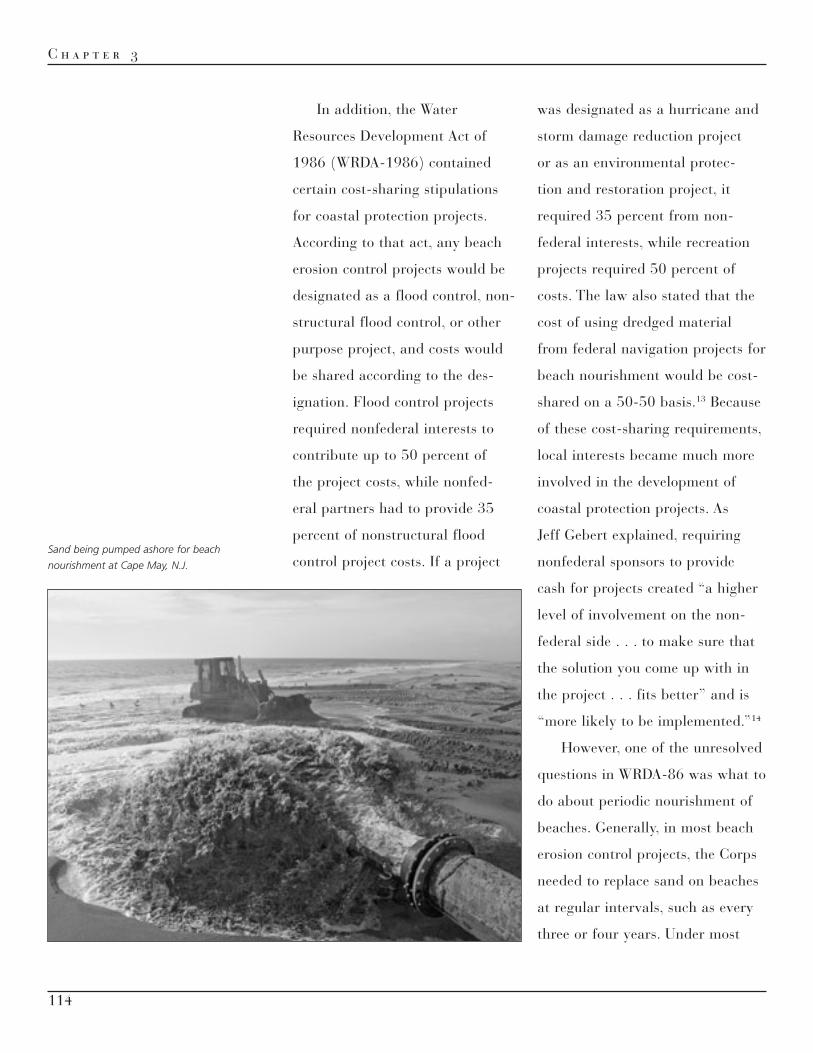
Sand being pumped ashore for beach
nourishment at Cape May, N.J.

115
S t o r m R i s k M a n a g e m e n t
coastal projects, the nonfederal
sponsor was responsible for the
operation, maintenance, repair,
and rehabilitation of the completed
project. Did periodic nourish-
ment fall into this category as
well? In 1992, Brig. Gen. Stanley
G. Genega, Director of the Corps’
Civil Works Program, issued a
memorandum stating that the
placement of additional sand on
beaches could be classified as con-
tinuing project construction and
should be cost-shared along the
same lines as general construction
(65 percent federal, 35 percent
nonfederal). As Acting Assistant
Secretary of the Army (Civil
Works) John H. Zirschky put it,
“Projects that are in this long-term
construction phase will continue as
Federal projects through the term
of the current agreements with
non-Federal sponsors.”15
As these new guidelines
were being established, Congress
directed the Philadelphia District
to initiate a new study addressing
both shores of Delaware Bay (as
opposed to the New Jersey-only
studies and previous separate
studies of the Delaware side).
On 1 October 1986, the House
Committee on Public Works and
Transportation passed a resolu-
tion requesting that the district
review “existing reports on com-
munities within the tidal portion
of the Delaware Bay” to develop
plans for coastal protection and “to
provide up-to-date information for
state and local management of this
coastal area.” The committee also
asked the district to decide whether
any previous recommendations for
the area should be modified.”16
Accordingly, the district produced a
reconnaissance report in 1991 that
“identified a number of problem
areas where erosion was negatively
impacting the adjacent shorelines.”
It recommended that feasibility
studies be conducted for projects
in some of these areas (but not all,
as some local communities were
not interested in sharing the cost
of additional studies), especially at
Broadkill Beach, Roosevelt Inlet/
Lewes Beach, and Mispillion Light
in Delaware, and at Cape May
Peninsula and Oakwood Beach
in New Jersey.17 The district con-
structed several projects at these
locations in the 1990s and 2000s.
116
C h a p t e r 3
Coastal Protection Projects in New Jersey
Meanwhile, Congress autho-
rized the Philadelphia District to
conduct a study of New Jersey’s
entire ocean shoreline to collect
data that would serve “as the
basis for actions and programs
to prevent the harmful effects
of shoreline erosion and storm
damage.” It also called specifi-
cally for “studies for beach erosion
control, hurricane protection and
related purposes . . . in areas iden-
tified as having potential for a
project, action or response which
is engineeringly, economically,
and environmentally feasible.”18
Because of the studies initiated by
the Philadelphia District at the
request of Congress in the 1986
and 1987 resolutions, the number
of coastal projects conducted by
the district increased greatly in
the 1990s. This followed a trend
in the Corps of Engineers as a
whole. According to one report, few
beach restoration projects occurred
in the 1980s “due to a lack of
water resource authorization.” The
1990s, however, saw “as many
projects completed in the 1990-93
period as there were during the
entire decade of the 80’s.”19
Another reason the
Philadelphia District saw its
coastal protection work grow
was that the state of New Jersey
became greatly interested in these
projects, largely because of two
storms that impacted the region.
Around Halloween in 1991, a
huge “nor’easter” hit the Atlantic
coast, causing high winds and
large waves along the coastline and
flooding several areas. In December
1992, another nor’easter pounded
the coast, causing “an astronomical
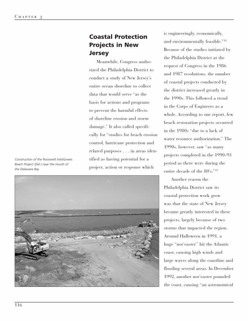
Construction of the Roosevelt Inlet/Lewes
Beach Project (Del.) near the mouth of
the Delaware Bay

117
S t o r m R i s k M a n a g e m e n t
high tide and rainfall, . . . flooding
of coastal marshes and some addi-
tional coastal washover.”20 Because
of the damages caused by these two
storms—both in monetary costs
and beach destruction—the state
of New Jersey passed legislation in
1992 establishing a shore protec-
tion fund using realty transfer fees.
According to the law, these moneys
could be used for “shore protection
projects associated with the protec-
tion, stabilization, restoration or
maintenance of the shore, including
monitoring studies and land acqui-
sition.” The state could also use
the funds to provide “the non-
federal share of any State-federal
project.”21 This allowed New
Jersey to partner with the Corps
on several beach erosion control
projects that the state wanted done.
As Gebert explained, “Before those
storms, the State of New Jersey
didn’t have a program where they
regularly set aside money every
year . . . for shore protection.” With
that funding, the state worked with
the Corps on several coastal pro-
tection projects.22
In the 1990s, the district began
a number of projects along the New
Jersey shoreline, some of which
were a part of the Delaware Bay
studies the Corps had performed
and some of which were in response
to additional needs identified by
the state. The first project to come
to fruition was at Cape May on
the southern tip of New Jersey, a
community “dominated by a resort
economy” and by “miles of ocean-
front beaches.”23 The Philadelphia
District had long-standing involve-
ment in beach erosion control in
this area. In 1907, Congress autho-
rized the Corps to construct two
4,400-foot-long jetties 850 feet
from each other to provide “a stable
inlet between Cape May Harbor
and the Atlantic Ocean.” Although
these jetties improved navigation,
they facilitated erosion down the
shore from the inlet, while creating
accumulation up the shore. In the
1990s, the Corps “determined that
76 percent of the shoreline erosion
in the Cape May Meadows area is
caused by the existing Federal nav-
igation works and the remaining
24 percent shoreline erosion is
caused by natural forces.” Local
and state interests had attempted
to stabilize the shoreline through

118
C h a p t e r 3
groin construction, but additional
measures were necessary.24
In the 1970s, the Philadelphia
District investigated implementing
a beach erosion control and storm
protection project from Cape May
Inlet to Lower Township, N.J. The
Water Resources Development Act
of 1976 authorized the Corps to
prepare a general design memo-
randum for the project, which
consisted of constructing new
groins along the coastline and
placing beachfill from Cape May
Inlet to Lower Township. The U.S.
Coast Guard had considerable
interest in the project because it
was losing land to beach erosion,
which threatened some of its
training operations.25
In the early 1980s, the Corps
completed the Phase I general
design memorandum for this
project, based largely on mitigating
the damage caused by the 1911
jetties; it called for new groins and
beachfill up to the existing 3rd
Street groin in the city of Cape
May, plus a deferred deposition
basin. The Corps began work in
1990 to add five hundred thousand
cubic yards of sand at Cape May,
completing initial beach construc-
tion in 1991. 26
Just a year after Cape May,
construction started on a second
major beach nourishment effort
along the Jersey shore. The Corps
had initially become involved in
the Great Egg Harbor Inlet and
Peck Beach Project in 1970, when
the House of Representatives
authorized the district to begin
a navigation and beach erosion
control project around Ocean
City. The state of New Jersey had
problems funding its share of the
project cost in the 1970s, but in
1983, it expressed interest in a
“scaled-down project.”27 Having
received authorization for this
under WRDA-86, the Philadelphia
District completed a general design
memorandum in 1989. The project
planned by the district called for
placing four million cubic yards of
beachfill along a point extending
from the Surf Road groin to
34th Street in Ocean City, using
835,000 cubic yards of sand to
repair erosion along the shore,
extending thirty-eight storm drain
outfall pipes, and providing beach
nourishment every three years.

119
S t o r m R i s k M a n a g e m e n t
The Corps characterized it as a
“$600 million, 50-year beachfill
project.”28
In September 1991, the state
of New Jersey and the Corps
concluded a local cooperation
agreement for the project, and
work began soon thereafter. When
Hurricane Felix hit the Atlantic
coast in August 1995, Philadelphia
District Engineer Lt. Col. Robert
Magnifico deemed the Ocean
City project a success, as it “per-
formed as designed. The event
didn’t destroy the integrity of the
project at all,” Magnifico said.
He characterized the project as
“epitomiz[ing] what ‘partnering’ is
all about.”29
In the 2000s, the district sup-
plemented this project with beach
erosion control work from Great
Egg Harbor Inlet to Townsends
Inlet, N.J. This project involved
placing beachfill from 34th Street
to 59th Street in Ocean City, as
well as nourishment of 403,000
cubic yards of sand every three
years “synchronized with the
existing Federal beachfill project
at Ocean City (Great Egg Harbor
Inlet to 34th Street).” The project’s The Cape May Inlet to Lower Township
Beach Nourishment Project

120
C h a p t e r 3
estimated cost was $33.6 million in
federal funding and $18.5 million
in nonfederal contributions.30
Aside from Cape May and
Ocean City, all the district’s sub-
sequent coastal storm damage
reduction projects along the Jersey
shore emerged from one com-
prehensive plan: the New Jersey
Shore Protection Study, the bulk
of which was conducted in the
1990s. Addressing the full length
of that state’s Atlantic coast-
line, it spun off a succession of
interim feasibility studies within
The Atlantic coastline of Ocean City, N.J., before
(above) and after (below) beach nourishment

121
S t o r m R i s k M a n a g e m e n t
Philadelphia District boundaries:
Manasquan Inlet to Barnegat Inlet,
Barnegat Inlet to Little Egg Inlet
(Long Beach Island), Brigantine
Island, Absecon Island, Great Egg
Harbor Inlet to Townsends Inlet,
Townsends Inlet to Cape May Inlet,
Hereford Inlet to Cape May Inlet,
and Lower Cape May Meadows
and Cape May Point. By 2008, all
but Hereford-Cape May had been
authorized for construction, and
the district had completed initial
beach nourishment for the central
portion of Long Beach Island (Surf
City and Ship Bottom), Brigantine
Beach, Atlantic City and Ventnor,
Avalon and Stone Harbor, and
Lower Cape May Meadows and
Cape May Point, as well as seawall
improvements at Avalon and North
Wildwood. (Harvey Cedars would
follow in 2010 as the second phase
on Long Beach Island.)31
The most visible among these
would be the Absecon Island
Project, as it included Atlantic
City—one of the preeminent
entertainment and resort centers
east of the Mississippi. Absecon
Island—which extends 8.1 miles
from Absecon Inlet to Great Egg
The Absecon Island Coastal Storm Risk
Reduction Project
Initial beach nourishment at
Brigantine, N.J.

122
C h a p t e r 3
Harbor Inlet and includes the com-
munities of Ventnor, Margate, and
Longport—had received much
attention from the Corps in the
twentieth century. In the 1920s,
Congress authorized a navigation
project for Absecon Inlet to estab-
lish an entrance channel twenty
feet deep by four hundred feet
wide. Congress also directed the
Corps to conduct beach erosion
control projects on Absecon Island
in 1954. This work involved
replacing damaged sheetwalls,
building the Brigantine Jetty, groin
construction, and widening of the
Absecon Inlet. In addition, the
Corps conducted periodic nour-
ishment on the island. However,
problems continued with beach
erosion and in 1976 Congress
authorized the district to proceed
with Phase I Design Memorandum
Stage of Advanced Engineering
and Design for Absecon Island
beach erosion. Congress reautho-
rized this project under WRDA-86.
After the Corps completed a cost-
sharing agreement for a feasibility
study with the state of New Jersey
in March 1993, it proceeded with
the preparation of that study.32
When the feasibility study was
concluded, it proposed constructing
a 200-foot-wide berm to an eleva-
tion of 8.5 feet NGVD (National
Geodetic Vertical Datum of 1929,
a geodetic vertical datum that
can establish a vertical reference
plane—elevation—relative to sea
level) and a dune with an elevation
of 16 feet NGVD at Atlantic City.
The Corps would also place beach-
fill and a 100-foot berm and dune
with an elevation of 14 feet NGVD
at Ventnor, Margate, and Longport.
Initial beachfill would consist of
7.1 million cubic yards of sand
deposited over 42,825 linear feet;
the Corps would also provide nour-
ishments of 1.7 million cubic yards
every three years. In addition,
the district would construct two
new bulkheads along the Absecon
Inlet where it fronted Atlantic
City to provide storm protection.33
Congress authorized this project in
the Water Resources Development
Act of 1996 (WRDA-1996),
estimating its total cost at $52
million.34
In July 2003, the Corps con-
cluded a project cooperation
agreement with the state of New

123
S t o r m R i s k M a n a g e m e n t
Jersey for construction, and the
initial beachfill construction began
in Atlantic City in December 2003
when 4.5 million cubic yards of
sand was pumped from Absecon
Inlet to the beach. Beachfill
construction at Ventnor was com-
pleted in June 2004. In 2008, the
Corps was still awaiting funding
to complete the second nourish-
ment cycle. However, the project
promised to provide a measure
of protection to Atlantic City and
Ventnor that was not there before.
Because of this, as one report
stated, the work “brought unprec-
edented local publicity—most
all positive—to the Corps’ shore
protection efforts along the Jersey
Shore.”35
In 1999, the Philadelphia
District developed another plan for
the Cape May peninsula, whereby
it would provide not only shore
protection but ecosystem restora-
tion as well. The Lower Cape May
Meadows Ecosystem Restoration
Project is discussed more fully in
Chapter Five, but the protective
features of the project included
the building of a protective berm
and dune system between the 3rd
Avenue terminal groin in Cape May
City and the Central Avenue groin
in Cape May Point. The Corps also
scheduled placing 650,000 cubic
yards of sand on the beach every
four years for the next fifty years,
using an offshore borrow site for
the sand. According to Gebert, this
was a significant project—before
Summer beachgoers at Cape May, in
view of the Cape May Point Lighthouse
Initial beach nourishment at Surf City
along New Jersey’s Long Beach Island

124
C h a p t e r 3
the district’s work in the 1990s,
there was no beach at Cape May.
“The City of Cape May had no
beach over most of the ocean
shoreline at Cape May City for 40
or 50 years before 1990,” Gebert
said. “They just had no sand.”
The district had to be conserva-
tive in its periodic nourishment
schedule to ensure that the beach
remained.36
Coastal Protection Projects in Delaware
New Jersey was not the only
location of beach erosion protection
projects; the Corps also performed
this work along the Delaware
coastline. Like New Jersey, the
state of Delaware had a history of
providing funding for this purpose;
as of 2001, newspapers estimated
that the state had spent $19
million to rebuild eroded beaches.
However, some communities were
still in need of shore protection,
and the state partnered with the
district to provide it. For example,
under Section 860 of WRDA-86,
Congress directed the Corps to
construct sand bypass facilities and
stone revetments at Indian River
Inlet in Delaware. Between 1938
and 1940, the Corps had con-
structed parallel jetties in the inlet
“to create a stable 500-ft-wide
inlet that provided a naviga-
tion pass for recreational boats.”
However, the construction of these
jetties led to “erosion of the unpro-
tected interior inlet shoreline.”37
In 1984, the Corps determined
that an environmentally and eco-
nomically feasible solution to the
erosion was to conduct “beach
nourishment utilizing a fixed
sand bypass plant” that would be
constructed on the south side of
the inlet. At the state’s request,
the fixed plant was replaced by
a semimobile jet pump system in
the plans. With this system, as a
district report explained, “Sand
would be removed from this
zone of accretion, transported by
pipeline north across the bridge
over the inlet, and deposited along
the 3500 foot section of beach
immediately north of the Inlet.”38
After gaining approval for this
project in WRDA-86, the district
completed installation in 1990.
Since then, the plants has been
operated and maintained by the

125
S t o r m R i s k M a n a g e m e n t
state of Delaware with federal
cost-sharing; it pumps an average
of a hundred thousand cubic
yards of material a year from the
south shore across the inlet to the
depleted north shore. According
to Gebert, this was the first time
the Philadelphia District had con-
ducted sand bypassing operations,
making it a landmark coastal
protection project.39 The district
and the state of Delaware received
an Outstanding Coastal Project
Award from the American Shore
and Beach Preservation Association
in 2001 for the sand bypassing
operation, because it “successfully
demonstrat[ed] ‘effective, long-
term, fixed-sand bypassing using
jet pump technology.’”40
One of the biggest shore pro-
tection efforts in Delaware began
in June 1988, when the Senate
Committee on Environment and
Public Works issued a resolution
requesting that the Corps review
an existing report on the Delaware
Coast to see if any shore and hur-
ricane protection projects were
feasible from Cape Henlopen to
The sand bypassing plant at Indian River
Inlet, Del., soon after construction
in 1989

126
C h a p t e r 3
Fenwick Island, Del. The Corps
had developed the existing report
in 1957, outlining shore protec-
tion plans for locations along both
Delaware Bay and the Atlantic
Ocean, including Kitts Hummock,
Slaughter Beach, Broadkill Beach,
Lewes Beach, Bethany Beach,
and a stretch of coastline from
Rehoboth Beach to the Indian
River Inlet. However, the Corps
had determined that the only eco-
nomically feasible projects were
those in the area from Rehoboth
Beach to Indian River Inlet.
Accordingly, Congress directed the
Corps in the River and Harbor Act
of 1958 to restore beaches along
that stretch of coastline and to
provide periodic nourishment.41
Two of the communities the
Corps envisioned protecting
under this project were Rehoboth
Beach and Dewey Beach. Located
in Sussex County in southern
Delaware, these adjacent towns
are popular recreation des-
tinations for residents of the
mid-Atlantic, especially from the
Washington-Baltimore area. The
Corps conducted hurricane protec-
tion and beach erosion prevention
studies in the 1960s, 1970s, and
1980s, but none of these projects
were implemented. The need
for such projects became more
pressing in the late 1980s when
Bethany Beach, South Bethany
Beach, and Fenwick Island (farther
Bethany Beach (top) and South Bethany
(bottom) show the effects of the 1992
nor’easter on Delaware’s Atlantic Coast

127
S t o r m R i s k M a n a g e m e n t
south than Rehoboth and Dewey,
but also in Sussex County) “experi-
enced a loss of shoreline protection
due to chronic erosion problems.”
These issues led Congress to pass
a resolution in 1988 asking the
Corps to revisit its studies on
this coastline. The Philadelphia
District, working with the
Delaware Department of Natural
Resources and Environmental
Control (DNREC), instituted fea-
sibility studies to determine which
coastal protection projects were
financially desirable. The first
study, which lasted from 1992 to
1995, dealt with Rehoboth Beach
and Dewey Beach; the second
(from 1995 to 1998) examined
Bethany Beach and South Bethany;
and the third (1997 to 2000) dealt
with Fenwick Island.42
In 1996, the Philadelphia
District issued its feasibility study
for Rehoboth Beach and Dewey
Beach, recommending, according to
one account, “the construction of
a 125-foot-wide berm and a dune
at Rehoboth Beach, a 150-foot-
wide berm and a dune at Dewey
Beach, and grass, dune fencing
and periodic beach nourishment at
both locations.”43 Congress autho-
rized this project in WRDA-1996.
According to this act, the project
involved “storm damage reduc-
tion and shoreline protection” at
Rehoboth Beach and Dewey Beach;
it would cost $9,423,000, with the
nonfederal sponsor contributing
$3,298,000. The project also would
provide periodic beach nourishment
for fifty years at an annual cost of
$282,000.44 The economic need
for the project seemed obvious; the
Federal Emergency Management
Agency (FEMA) issued a report
in June 2000 stating that the two
towns might lose an average of
three to four feet of beach each
year for the next sixty years. “If
the state were forced to buy and
Dredging and pumping operations for
beach nourishment contracts typically
continued round the clock

128
C h a p t e r 3
relocate oceanfront homes,” one
report stated, “costs could rise as
high as $300 million.”45
In December 2003, the Corps
entered into a project coopera-
tion agreement with DNREC to
construct the project at Rehoboth
Beach and Dewey Beach. This
agreement established the depart-
ment as the non-federal sponsor
of the project’s construction and
enabled the Corps to begin work
on the necessary measures. By
July 2005, the beachfill part of
the project had been completed,
and the placement of dune grass,
dune fencing, and crossovers had
occurred by January 2006. The
district estimated that periodic
nourishment would be needed on
the beaches “every three years
to ensure the integrity of the
design.”46
Meanwhile, between 1995 and
1998, the Corps examined shore
and hurricane protection measures
for Bethany Beach/South Bethany.
The district determined that the
project was feasible and developed
a plan to construct a 150-foot-
wide berm to an elevation of 7 feet
NAVD (North American Vertical
Datum of 1988, an updated
geodetic vertical datum that can be
referenced to the aforementioned
NGVD 29) and a dune to 16 feet
NAVD over a 2.8-mile distance.47
The district also proposed depos-
iting an initial beachfill of 3.5
million cubic yards and nourish-
ments of 480,000 cubic yards
every three years. Congress autho-
rized this project in the Water
Resources Development Act of
1999, estimating that it would cost
$22,205,000, of which the nonfed-
eral sponsor would pay $7,772,000.
Periodic nourishment would cost
$1,584,000 a year for fifty years.
On 26 July 2006, the Corps signed
Beachfill operations at Rehoboth
Beach, Del.

129
S t o r m R i s k M a n a g e m e n t
a project cooperation agreement
with DNREC, committing the latter
to serve as the project’s nonfederal
sponsor, and construction began.
Initial construction was completed
in June 2008.48
The final part of the Corps’
three-pronged approach to
southern Delaware coastline pro-
tection was work at Fenwick
Island. As mentioned earlier, the
Corps conducted a feasibility
study of that area from 1997 to
2000, recommending a project
involving the construction of a
200-foot-wide berm to an eleva-
tion of 7.7 feet NAVD and a dune
to 17.7 feet NAVD covering a
6,500-foot-long area extending
from the Maryland border to
Fenwick Island State Park. The
Corps recommended placement of
595,400 cubic yards of beachfill at
Fenwick Island, as well as nourish-
ment every four years. Congress
approved this project in the Water
Resources Development Act of
2000, estimating the total cost at
$5,633,000, with a nonfederal
share of $1,972,000. In 2004, the
Corps completed a project coop-
eration agreement with DNREC;
Construction of the Bethany Beach/
South Bethany Project

130
C h a p t e r 3
initial construction was completed
in November 2005.49
In view of the three major
shore protection projects the Corps
did for the state of Delaware in
the 2000s, Gebert considers that
decade as a “watershed” for the
state. From Delaware’s perspective,
protecting the shoreline—espe-
cially the resort areas of Rehoboth
Beach, Dewey Beach, Bethany
Beach/South Bethany, and Fenwick
Island—was of paramount impor-
tance, as it was to New Jersey. As
Gebert explained, coastal projects
were generally done for “coastal
communities with a significant
density of residential and business
and public infrastructure [that
was], for the most part, open to
the public.” The increase in the
district’s work in this area in the
1990s and 2000s expanded the
number of employees working
on coastal projects and gave the
district the reputation as one of the
Corps’ experts in coastal planning.
In fact, beginning in the 2000s,
the Corps had the Philadelphia
District conduct an annual course
for Corps planners on coastal engi-
neering and planning.50
Initial nourishment at Fenwick Island,
southernmost of three storm risk
reduction projects covering Delaware’s
Atlantic Coast

131
S t o r m R i s k M a n a g e m e n t
Inlet Navigation Improvement Projects
In addition to its beach erosion
control and shore protection
projects, the Philadelphia District
improved inlet navigation through
its coastal program, funded largely
from its operations and mainte-
nance account. Barnegat Inlet in
Ocean County, New Jersey, was one
area where the Corps performed
this type of work. The main link
connecting the Atlantic Ocean
and Barnegat Bay, Barnegat Inlet
separates Island Beach State Park
and Long Beach Island.51 According
to one source, the inlet had “a long
history of shifting. . . . Before it was
first stabilized in 1940, the inlet
was known to move as much as 40
feet a year.”52 As a Corps engineer
explained, “Fishermen could go out
one week, come back a week later
and the channel wasn’t in the same
place as when they left.”53
To deal with this problem,
Congress authorized the Corps to
take several measures as part of the
Barnegat Inlet, N.J., widely considered
one of the most treacherous inlets on the
Atlantic Coast before rehabilitation of the
south jetty was completed in 1991

132
C h a p t e r 3
federal navigation project autho-
rized in 1935. The Corps built a
groin by Barnegat Lighthouse on
the south side of the inlet, con-
structed a north jetty and a south
jetty and dredged a flood shoal
in 1939, and built a sand dike in
1943 “in an attempt to ‘train’ the
tidal flow to follow a straighter
path through the remaining
channel.” Sediment deposition in
the channel meant that the district
had to dredge the channel “on
an annual or semi-annual basis
between 1972 and 1981.”54 The
goal of the dredging and the rest of
the Corps’ work was to maintain
a channel 8 feet deep through
the inlet and 10 feet deep through
the outer bar, a channel of suitable
hydraulic characteristics extending
in a northwesterly direction from the
gorge in the inlet to Oyster Creek
channel and through the latter
channel to deep water in the bay,
and the maintenance of a channel
8 feet deep and 200 feet wide to
connect Barnegat Light Harbor with
the main inlet channel.55
In the 1960s and 1970s, the
Corps’ Waterways Experiment
Station conducted studies that
“concluded that the construction
of a new south jetty parallel to
the existing north jetty and a
90-[meter] wide, 3-[meter] deep
channel would provide inlet
and channel stability.”56 The
Philadelphia District conducted its
own study of whether any modi-
fications to the 1935 navigation
plan were warranted, determining
in 1974 that modifications should
occur along the lines outlined by
the Waterways Experiment Station.
Congress authorized preconstruc-
tion planning in 1976; in 1981,
the Corps issued a general design
memorandum that determined
that, in the words of District
Engineer Lt. Col. Roger Baldwin,
“the most significant problem . . .
was the instability and shoaling
of the Barnegat Inlet navigation
channel,” in large part because
the south jetty’s alignment did not
“properly confine the flow to any
specific channel” and because sand
brought in by ocean currents gen-
erally accumulated at the entrance
to the channel.57
In 1985, Congress autho-
rized the Corps to begin the
new construction, based on the
Corps’ determination of a design

133
S t o r m R i s k M a n a g e m e n t
deficiency associated with the
earlier project. Accordingly, when
the Corps signed a local coop-
eration agreement with the state
of New Jersey for the work in
May 1986, the federal share of
the cost was set proportionately
higher. This agreement stated that
the district would improve the
navigation channel in the inlet by
building a new south jetty and by
dredging “a 10 foot deep, 300 feet
wide navigation channel,” as well
as removing a shoal between the
proposed channel and the north
jetty and constructing “jetty sport
fishing facilities.”58 As the non-
federal sponsor, the state would
contribute 35.4 percent of the cost
of construction. After the passage
of WRDA-1986, the agreement was
amended so that the state would
provide “a cash contribution equal
to 10 percent of the total costs of
construction of general navigation
facilities” and up to 50 percent of
the cost of the recreation facili-
ties.59 With these agreements in
place, the Philadelphia District
oversaw the construction of the
new south jetty between 1987 and
1991. According to one report, part
of the work involved “angl[ing] the
rocks more to the south of the due
east direction that the old South
Jetty had pointed, to better funnel
the water flow.”60
In the years that followed, the
Philadelphia District continued to
dredge the inlet periodically and
to monitor project conditions. In
addition, it conducted a variety
of other work at Barnegat Inlet,
including protecting the Barnegat
Lighthouse when it discovered in
2000 that “underwater erosion
was threatening the base of the
lighthouse.” This $1.38 million
project involved “placing 160
stone-filled ‘mattresses’—each
four inches thick, six feet wide
The plan for Barnegat Inlet involved
construction of an entirely new south
jetty backfilled with sand dredged
from the inlet

134
C h a p t e r 3
and twenty feet long—in the
deepest part of the slope to shore
up the eroded rock.”61 In 2002,
the district completed the installa-
tion of an anti-erosional geotextile
fabric across the south jetty that
would act as a filter to prevent
sand loss. The Corps had discov-
ered that “water was working its
way through the jetty unimpeded,”
causing erosion behind and under-
neath the structure. With the fabric
in place, water would be able to
travel through without taking sand
with it.62
The innovative technology the
district used at Barnegat Inlet illus-
trated the importance of staying
abreast of new features in coastal
planning. Because of its work
on the New Jersey and Delaware
shorelines, the Philadelphia District
was often on the cutting edge of
these technologies. This was espe-
cially evident in the Corps’ work
at Manasquan Inlet, which divides
Improving erosion protection around
Barnegat Light

135
S t o r m R i s k M a n a g e m e n t
Monmouth and Ocean counties in
New Jersey and is “the northern-
most connection between the ocean
and the New Jersey Intracoastal
Waterway.” Between 1881 and
1883, and again in 1922, local
interests attempted to stabilize
the inlet, which tended to migrate
as much as a mile north of its
present location, by constructing
timber jetties. When these failed
to work, Congress authorized the
Corps in 1930 to construct two
parallel stone jetties four hundred
feet apart. Although these jetties
provided the necessary stabiliza-
tion, they experienced frequent
storm damage between 1935 and
1975, especially on the outer
ends, where stone would be dis-
lodged and displaced. In 1978,
the Philadelphia District came
up with an innovative solution to
protect the jetties and, by exten-
sion, the inlet.63 The district
proposed rehabilitating the jetties
using a slightly modified version
of dolosse, structures designed by
a South African coastline engineer
to combat erosion. Described by
one source as eleven-foot-high
“concrete jacks” weighing sixteen
tons and reinforced with steel, the
dolosse interlocked to form an
improved protective armor layer
around the jetties. Between 1980
and 1982, the district placed 1,343
dolosse around the north and south
jetties; this was the first time the
structures had been used on the
east coast of the United States.
The dolosse provided much-needed
protection, but between 1982 and
1997, about five of them were
damaged and others moved from
their original location. To provide
further protection, the Philadelphia
District placed forty CORE-LOC®
structures (developed by the U.S.
Army Engineer Research and
Manasquan Inlet, N.J., where “dolosse”
were first used on the Atlantic Coast

136
C h a p t e r 3
Development Center) at the heads
of the north and south jetties in
1997. Though similar to dolosse,
the CORE-LOCs had “three
‘flukes’ (opposing sets of legs)
instead of just two” and weighed
three more tons. “The extra fluke
helps strengthen the structure
against breakage,” a district article
noted, while “the extra weight
makes the coreloc less susceptible
to movement due to wave action.”
In the words of Philadelphia
District project manager Jerry
Jones, the CORE-LOCs interlocked
with the dolosse “in much the same
way that armor mail once worked
to protect a medieval knight.” Use
of the CORE-LOCs was another
example of the district’s ability to
innovate; this was the first time
they had been used in the United
States.64
* * * * * * *
Putting the dolosse into place at
Manasquan Inlet

137
S t o r m R i s k M a n a g e m e n t
Coastal projects were a large
part of the workload of the
Philadelphia District, whether they
involved beach erosion control
or navigation improvement. The
district conducted a number of
projects for the states of New Jersey
and Delaware between 1972 and
2008, projects that together con-
stituted one of the largest coastal
programs in the nation. The district
emerged from these projects as one
of the leading authorities in the
United States on coastal protection
and planning. Perhaps more
important, the projects provided
a previously unknown measure of
protection to coastal communities,
enhanced recreational opportunities
along the coastline, and improved
navigation of coastal inlets. Not
everyone agreed that the federal
government should foot the bill
to protect these communities, but
the district gained satisfaction
from what it accomplished techni-
cally in meeting a challenge from
Congress.
CORE-LOCs and dolosse working in
combination along Manasquan Inlet

C h a p t e r 3 — E n d n o t e s
138
1 Department of the Army, U.S. Army Corps of Engineers, “Hydraulic Design for Coastal Shore Protection Projects,” Engineering Regulation (ER) No. 1110-2-1407, 1, B-1 <http://140.194.76.129/publications/eng-regs> (16 April 2010) (hereafter referred to as ER 1110-2-1407).
2 Jeff Gebert interview by Joshua Pollarine, 19 October 2009, Philadelphia, Pennsylvania, transcript, 16–17, 29.
3 Gebert interview, 6–7. The Philadelphia District’s coastal planning work (whether for beach erosion control, hurricane protection, or navigation improvement) initially was done out of the Coastal and Special Studies Section of the Planning Branch in the Engineering Division. When the Planning Division was created in 1987, the Coastal Planning Section shifted to the Project Development Branch of the Planning Division. John Tunnell email to Jeff Gebert and Joshua Pollarine, 10 May 2010; copy in posses-sion of the authors.
4 Quotations in U.S. Army Corps of Engineers, Water Resources Support Center, Institute for Water Resources, Shoreline Protection and Beach Erosion Control Study: Final Report: An Analysis of the U.S. Army Corps of Engineers Shore Protection Program, IWR Report 96-PS-1 (Alexandria, Va.: U.S. Army Corps of Engineers, Water Resources Support Center, Institute for Water Resources, 1996), II-2 – II-6; see also Snyder and Guss, The District, 208–209.
5 U.S. Army Corps of Engineers, Philadelphia District, Small Projects Program (pamphlet) (Philadelphia: Philadelphia District, U.S. Army Corps of Engineers, n.d.), n.p.
6 Department of the Army, Philadelphia District, Corps of Engineers, “Survey Study, Beach Erosion Control and Hurricane Protection, Delaware Bay Shore, New Jersey, Plan of Survey,” June 1974, 3, File Del. Bay Shore, N.J. Work Sheets, Box 223, Philadelphia District-AR.
7 As cited in Department of the Army, Philadelphia District, Corps of Engineers, “Survey Study, Beach Erosion Control and Hurricane Protection, Delaware Bay Shore, New Jersey: Feasibility Report,” August 1979, 1 (hereafter referred to as Delaware Bay Shore Feasibility Report, 1979), File Delaware Bay Shore, New Jersey, “Final Feasibility Report,” Report and Inclosures [sic], Box 223, Philadelphia District-AR.
8 T. R. Hudson to Corps of Army Engineers, U.S. Department of the Army, 28 October 1976, File 1518-01 Delaware Bay Shore of N.J., Correspondence 1975-76-77, Box 223, Philadelphia District-AR.
9 Delaware Bay Shore Feasibility Report, 1979, 33.
10 Quotation in Anthony R. Wood, “New Jersey Expected to Get $20.7 Million for Beaches,” Philadelphia Inquirer, 14 October 2009; see also “In Defense of Jersey’s Shores,” Philadelphia Inquirer, 8 March 2000, online edition <http://marine.rutgers.edu/cool/education/coast09.html> (14 April 2010).
11 See “Navigation, Beachfill Projects Under New Scrutiny,” The Observer (July 1995): 3; John H. Zirschky, Acting Assistant Secretary of the Army (Civil Works), to Mr. Stan Tait, President, Florida Shore and Beach Preservation Association, n.d., Harry Shoudy’s Files, Office of History.
12 National Oceanic and Atmospheric Administration, Coastal Services Center, “Beach Nourishment: A Guide for Local Government Officials” <http://www.csc.noaa.gov/beachnourishment/html/human/law/history.htm> (16 April 2010).
13 Water Resources Development Act of 1986 (100 Stat. 4082); NOAA, “Beach Nourishment: A Guide for Local Government Officials.”
14 Gebert interview, 5–6.
15 Quotation in Zirschky to Tait, n.d.; see also Brigadier General Stanley G. Genega, Director of Civil Works, Memorandum for Major Subordinate Commands and District Commands, 17 November 1992, Harry Shoudy’s Files, Office of History.
16 As cited in Department of the Army, Philadelphia District, Corps of Engineers, “Delaware Bay Coastline, Delaware and New Jersey: Reconnaissance Report, August 1991,” 1, Box 246, Philadelphia District-AR.
17 Philadelphia District, “Delaware Bay Coastline,” 133–135. The Corps had previously completed beach erosion control projects at Broadkill Beach and Lewes Beach, but by the early 1990s, “the 10 year period for federal involvement in period nourishment [had] lapsed.” “Delaware Bay Coastline, New Jersey and Delaware, Reconnaissance Review Conference, 13 August 1992,” 1, File Del. Bay RRC, Slides w/ Green Slide Book, Box 247, Philadelphia District-AR.
18 Committee on Public Works and Transportation, U.S. House of Representatives, “Resolution: Coast of New Jersey, Erosion and Storm Effects Study, Docket No. 2294,” 10 December 1987, document provided by Jeff Gebert, Chief, Coastal Planning, Philadelphia District, Philadelphia, Pennsylvania.
19 ER 1110-2-1407, 1.
20 Quotation in Kelvin W. Ramsey, John H. Talley, and Darlene V. Wells, “Summary Report: The Coastal Storm of December 10-14, 1992, Delaware and Maryland,” State of Delaware Geological Survey Open File Report No. 37, February 1993, 22, document provided by Jeff Gebert; see also NOAA Satellite and Information Service, “The Perfect Storm: October 1991” <http://www.ncdc.noaa.gov/oa/satellite/satelliteseye/cyclones/pfctstorm91/pfctstorm.html> (16 April 2010); Gebert interview, 8.
21 Senate Budget and Appropriations Committee, Statement to Assembly No. 1676, State of New Jersey, 10 December 1998, document provided by Jeff Gebert.
22 Gebert interview, 8.
23 “Cape May County,” 195–196, File Delaware Bay Shore, Erosion Rater (George Hicks), Box 223, Philadelphia District-AR.
24 Quotations in Lieutenant General Joe N. Ballard, Chief of Engineers, to The Secretary of the Army, 5 April 1999, document provided by Jeff Gebert; see also “Appendix D, Study of Sand Bypassing Options at Cape May Inlet, New Jersey,” 31 January 1991, document provided by Jeff Gebert.
25 See U.S. Army Corps of Engineers, Philadelphia District, “Cape May Inlet to Lower Township, New Jersey: Phase I General Design Memorandum,” Draft, March 1980, document provided by Jeff Gebert; John E. Tunnell email to Jeffrey Gebert and Joshua Pollarine, 3 May 2010, copy in possession of the authors.
26 U.S. Army Corps of Engineers, Philadelphia District, “Cape May Inlet to Lower Township, New Jersey: Phase I General Design Memorandum,” Draft, March 1980, document provided by Jeff Gebert; John E. Tunnell email to Jeffrey Gebert and Joshua Pollarine, 3 May 2010, copy in possession of the authors; see also Ballard to The Secretary of the Army, 5 April 1999; “Nourishment Continues at Cape May,” The Observer (December 1992): 5; U.S. Army Corps of Engineers, Philadelphia District, “Project Factsheet: Cape May Inlet to Lower Township, N.J., January 2010” <http://www.Philadelphia District.usace.army.mil/ cePhiladelphia District-dp/projects/factsheets/NJ/4CG_CapeMayInlet_to_LowerTwp.pdf> (20 April 2010).
27 Unpublished Morgan Draft District History, 88–89.
28 Quotations in “Felix is No Match for Jersey Shore Partnership,” The Observer (September 1995): 10; see also “Ocean City Beach Replenishment Begins: City’s Ocean Front Gets a Facelift,” The Observer (November 1994): 3; Unpublished Morgan Draft District History, 88–89; “Local Cooperation Agreement Between the Department of the Army and the State of New Jersey for Construction of the Great Egg Harbor Inlet and Peck Beach, New Jersey Project,” 18 September 1991, document provided by Jeff Gebert; Gebert interview, 10.
29 Quotations in “Felix is No Match for Jersey Shore Partnership,” The Observer (September 1995): 10; see also “Ocean City Beach Replenishment Begins: City’s Ocean Front Gets a Facelift,” The Observer (November 1994): 3; Unpublished Morgan Draft District History, 88–89; “Local Cooperation Agreement Between the Department of the Army and the State of New Jersey for Construction of the Great Egg Harbor Inlet and Peck Beach, New Jersey Project,” 18 September 1991, document provided by Jeff Gebert; Gebert interview, 10.
30 Lieutenant General Carl A. Strock, Chief of Engineers, to The Secretary of the Army, 24 October 2006, document provided by Jeff Gebert.
31 Edward Voigt, Chief, Public & Legislative Affairs, Philadelphia District, personal communication with Joshua Pollarine, 4 April 2011.
32 House, New Jersey Shore Protection Study: Communication from the Acting Assistant Secretary (Civil Works), the Department of the Army, Transmitting a Report on a Storm Damage Reduction and Shoreline Protection Project for Brigantine Inlet to Great Egg Harbor Inlet, Absecon Island, New Jersey, Pursuant to Pub. L. 104-303, Sec. 101(b)(13), 105th Cong., 1st sess., 1997, H. Doc. 105-153, serial 14432, 15–16.
33 House, New Jersey Shore Protection, 187; “Brigantine Inlet to Great Egg Harbor Inlet, Shore Protection Project,” The Observer (October/November 2003): 9; Lieutenant

C h a p t e r 3 — E n d n o t e s
139
General Joe N. Ballard, Chief of Engineers, to The Secretary of the Army, 23 December 1996, document provided by Jeff Gebert.
34 Water Resources Development Act of 1996 (110 Stat. 3658).
35 Quotations in “Coastal Construction Moves Forward in N.J., Del.,” The Observer (Autumn 2004): 7; see also “Brigantine Inlet to Great Egg Harbor Inlet, Shore Protection Project,” 9; U.S. Army Corps of Engineers, Philadelphia District, “Project Factsheet: New Jersey Shore Protection, Brigantine Inlet to Great Egg Harbor Inlet, Absecon Island, N.J.,” March 2010 <http://www.Philadelphia District.usace.army.mil/cePhiladelphia District-dp/projects/factsheets/NJ/4CG_NJShore%20Protection_Absecon%20Island.pdf> (30 April 2010); “Project Cooperation Agreement Between the Department of the Army and the State of New Jersey Department of Environmental Protection, Brigantine Inlet to Great Egg Harbor Inlet, Absecon Island, NJ, Shore Protection Project,” 31 July 2003, document provided by Jeff Gebert.
36 Quotation in Gebert interview, 11; see also Ballard to The Secretary of the Army, 5 April 1999; “Nourishment Continues at Cape May,” The Observer (December 1992): 5; U.S. Army Corps of Engineers, Philadelphia District, “Project Factsheet: Cape May Inlet to Lower Township, N.J., January 2010” <http://www.Philadelphia District.usace.army.mil/cePhiladelphia District-dp/projects/factsheets/NJ/4CG_CapeMayInlet_to_LowerTwp.pdf> (20 April 2010). In addition to these projects, the Philadelphia District completed a variety of other coastal protection projects for the state of New Jersey in the 1990s and 2000s, including projects involving seawall construction at Avalon and Stone Harbor.
37 Quotations in The Committee on Tidal Hydraulics, “Indian River Inlet: An Evaluation by the Committee on Tidal Hydraulics,” July 1994, 6, document provided by Jeff Gebert; see also Water Resources Development Act of 1986 (100 Stat. 4082).
38 U.S. Army Corps of Engineers, Philadelphia District, “Atlantic Coast of Delaware: General Design Memorandum and Environmental Assessment,” July 1984, Syllabus, copy in Philadelphia District-Library.
39 Gebert interview, 6–7.
40 “Two District Projects Receive National Recognition,” The Observer (Summer 2001): 10. The article noted that the bypass operation was “now operated and main-tained by the Delaware Department of Natural Resources and Environmental Control”; Voigt personal communication.
41 House, Beach Nourishment Project: Communication from the Acting Assistant Secretary (Civil Works), the Department of the Army, Transmitting a Report on the Storm Damage Reduction and Shoreline Protection Project for Rehoboth Beach and Dewey Beach, Delaware, Pursuant to Section 101(b)(6) of the Water Resources Development Act of 1996, 105th Cong., 1st sess., 1997, H. Doc. 105-144, serial 14429, 9, 16-18 (hereafter referred to as Beach Nourishment Project); “Delaware Shore Plans Unveiled at Public Hearing,” The Observer (March 1996): 5; Lieutenant General Joe N. Ballard, Chief of Engineers, to The Secretary of the Army, 23 December 1996, document provided by Jeff Gebert; “Public Perspective,” The Observer (January/February 2001): 16; Voigt personal communication.
42 House, Beach Nourishment Project, 9; Voigt personal communication.
43 “Delaware Shore Plans Unveiled at Public Hearing,” 5.
44 Water Resources Development Act of 1996 (110 Stat. 3667).
45 “Public Perspective,” The Observer (January/February 2001): 16. This was a reprint of an article published in the Baltimore Sun on 18 February 2001.
46 Quotations in U.S. Army Corps of Engineers, Philadelphia District, “Project Factsheet: Delaware Coast from Cape Henlopen to Fenwick Island, Rehoboth Beach/Dewey Beach, DE,” January 2010 <http://www.Philadelphia District.usace.army.mil/cePhiladelphia District-dp/projects/factsheets/DE/4CG_DelCoast_Rehoboth%20Dewey.pdf> (27 April 2010); see also “Project Cooperation Agreement Between the Department of the Army and the Delaware Department of Natural Resources and Environmental Control for Construction of the Delaware Coast from Cape Henlopen to Fenwick Island, Delaware, Rehoboth Beach and Dewey Beach, Delaware Project,” 19 December 2003, document provided by Jeff Gebert.
47 In 1988, the NGVD was renamed North American Vertical Datum.
48 U.S. Army Corps of Engineers, Philadelphia District, “Project Factsheet: Delaware Coast from Cape Henlopen to Fenwick Island, Bethany Beach/South Bethany, DE,”
January 2010 < http://www.Philadelphia District.usace.army.mil/cePhiladelphia District-dp/projects/factsheets/DE/4CG_DelCoast_Bethany%20S%20Bethany.pdf> (28 April 2010); Water Resources Development Act of 1999 (113 Stat. 269); Lieutenant General Joe N. Ballard, Chief of Engineers, to The Secretary of the Army, 21 April 1999, document provided by Jeff Gebert; “Project Cooperation Agreement between the Department of the Army and the Delaware Department of Natural Resources and Environmental Control for Construction of the Delaware Coast from Cape Henlopen to Fenwick Island, Bethany Beach to South Bethany, Delaware, Hurricane and Storm Damage Reduction Project,” 26 July 2006, document provided by Jeff Gebert.
49 U.S. Army Corps of Engineers, Philadelphia District, “Project Factsheet: Delaware Coast from Cape Henlopen to Fenwick Island, Fenwick Island, DE,” January 2010 <http://www.Philadelphia District.usace.army.mil/cePhiladelphia District-dp/projects/factsheets/DE/4CG_DelCoast_Fenwick%20Island.pdf> (28 April 2010); Lieutenant General Robert B. Flowers to The Secretary of the Army, 29 December 2000, docu-ment provided by Jeff Gebert; Water Resources Development Act of 2000 (114 Stat. 2572); “Project Cooperation Agreement between the Department of the Army and the Delaware Department of Natural Resources and Environmental Control for Construction of the Delaware Coast from Cape Henlopen to Fenwick Island, Delaware Project,” 13 September 2004, document provided by Jeff Gebert.
50 Quotations in Gebert interview, 9, 29, 32-33; see also “Planning Associates Coastal Course,” 27 April-1 May 2009, Powerpoint presentation provided by Jeff Gebert.
51 William C. Seabergh, Mary A. Cialone, and John W. McCormick, “Inlet Modifications and the Dynamics of Barnegat Inlet, New Jersey,” Journal of Coastal Research 19 (2003): n.p., document provided by Jeff Gebert.
52 “‘Old Barney’ Gets New Lease on Life,” The Observer (January/February 2001): 4.
53 As cited in Maria Scandale, “Rock Steady: Jetty Stones Shored Up To Stem Erosion,” The Observer (September/October 2002): 15.
54 Seabergh, Cialone, and McCormick, “Inlet Modifications and the Dynamics of Barnegat Inlet, New Jersey,” n.p.
55 U.S. Army Corps of Engineers, Philadelphia District, “Project Factsheet: Barnegat Inlet, Ocean County, NJ,” January 2010 <http://www.Philadelphia District.usace.army.mil/cePhiladelphia District-dp/projects/factsheets/NJ/5OM_BarnegatInlet.pdf> (30 April 2010).
56 Seabergh, Cialone, and McCormick, “Inlet Modifications and the Dynamics of Barnegat Inlet, New Jersey,” n.p.
57 Quotations in U.S. Army Corps of Engineers, Philadelphia District, “Barnegat Inlet, Ocean County, New Jersey, Transcript, 26 August 1981 Public Meeting,” 3–5, copy in Philadelphia District-Library; see also U.S. Army Corps of Engineers, Philadelphia District, “Barnegat Inlet, Ocean County, New Jersey: Phase II, General Design Memorandum,” August 1984, Syllabus, copy in Philadelphia District-Library.
58 Quotations in “Agreement Between the Department of the Army and the State of New Jersey for Local Cooperation at Barnegat Inlet, Ocean County, New Jersey,” 19 May 1986, document provided by Jeff Gebert; see also Act of 15 August 1985 (99 Stat. 293); Voigt personal communication.
59 “Modification No. 1 to the Agreement Between the Department of the Army and the State of New Jersey for Local Cooperation at Barnegat Inlet, Ocean County, New Jersey,” 20 March 1987, document provided by Jeff Gebert.
60 Scandale, “Rock Steady,” 15.
61 “‘Old Barney’ Gets New Lease on Life,” 4.
62 “Jetty Work Almost Done, Summerlong Repairs Will Leave Sinkholes Fixed,” The Observer (July/August 2002): 17.
63 Quotation in Jeffrey A. Gebert and J. Michael Hemsley, “Monitoring of Jetty Rehabilitation at Manasquan Inlet, New Jersey,” Monitoring Completed Coastal Projects Program Miscellaneous Paper CERC-91-8, September 1991, 1-2, document provided by Jeff Gebert; see also Gebert interview, 13–14; “Manasquan Inlet History,” document provided by Jeff Gebert.
64 Quotations in “Another ‘First’ Set in Place at Manasquan Inlet,” The Observer (September/October 1997): 3; see also “Manasquan Inlet History”; Gebert interview, 13–14; Voigt personal communication.


