1
CHAPTER 4.1.9 GROUND WATER RESOURCES
DHARMAPURI DISTRICT
2
INDEX
CHAPTER PAGE NO.
INTRODUCTION 3
DHARMAPURI DISTRICT – ADMINISTRATIVE SETUP 3
1. HYDROGEOLOGY 3-7
2. GROUND WATER REGIME MONITORING 8-15
3. DYNAMIC GROUND WATER RESOURCES 15-24
4. GROUND WATER QUALITY ISSUES 24-25
5. GROUND WATER ISSUES AND CHALLENGES 25-26
6. GROUND WATER MANAGEMENT AND REGULATION 26-32
7. TOOLS AND METHODS 32-33
8. PERFORMANCE INDICATORS 33-36
9. REFORMS UNDERTAKEN/ BEING UNDERTAKEN
/ PROPOSED IF ANY
10. ROAD MAPS OF ACTIVITIES/TASKS PROPOSED
FOR BETTER GOVERNANCE WITH TIMELINES AND
AGENCIES RESPONSIBLE FOR EACH ACTIVITY
3
GROUND WATER REPORT OF DHARMAPURI DISTRICT
INRODUCTION :
In Tamil Nadu, the surface water resources are fully
utilized by various stake holders. The demand of water is increasing day by day. So,
groundwater resources play a vital role for additional demand by farmers and
Industries and domestic usage leads to rapid development of groundwater. About
63% of available groundwater resources are now being used. However, the
development is not uniform all over the State, and in certain districts of Tamil Nadu,
intensive groundwater development had led to declining water levels, increasing
trend of Over Exploited and Critical Firkas, saline water intrusion, etc.
ADMINISTRATIVE SET UP
Dharmapuri District with a geographical area of 9641.03
Sq.Kms. is located on the North Western corner of the Tamil Nadu State. It lies in
between North Latitude 11⁰47’00”and 12⁰53’00”and East Longitudes 77⁰28’00”and
78⁰45’00” falling in Survey of India topographical maps Nos.57L,58H, and 58E and
58I.
The Dharmapuri District comprises of 3 Revenue divisions, 10 Taluks, 18
Blocks,22 Firkas 1106 Revenue Villages.
Dharmapuri District is totally bifurcated into 22 Firkas
1. HYDROGELOGY (i) Major Geological formations:
Geology:
Geologically Dharmapuri District is covered by crystalline rocks of Archaean
age.
a) Crystalline rocks:
The entire district is underlain by hard crystalline rocks of Archaean age
comprising of various rock types such as Gneiss, Charnockite, etc., The Gneissic
type of crystalline formation is found in the north and north eastern part of the district.
Shoolagiri, Hosur, Denganikottai and Kelamangalam areas are covered by Granitic
4
Gneiss. Veppanapalli, Krishnagiri and parts of Kaveripaattinam areas are covered by
peninsular Gneiss. Bargur, part of Kariamangalam, Palacode, Pochampalli and
Uthangarai are covered by Biotite Gneiss. Part of Harur, Uthangarai and
Morappurareas are covered by foliated gneiss.
Charnockite occurs in the southern part of the district, covering part of
Palacode, part of Morappur, Pappireddipatti, part of Dharmapuri, Pennagaram and
Nallampalli. Quartzites are found in patches in Denganikottai block. Dolerite dykes
varying from few feet to few miles in length cut across the country rock in this district.
Alluvial deposits such as sand, silt, clay and gravels which are transported
sediments by the river Ponnaiyar and Chinnar are found on either side of the river
courses. These formations are overlying the hard rocks as a thin layer.
In Dharmapuri district, weathered thickness ranges from 8 m to 15 m bgl. And
jointed formation ranges from 15 m to 60 m in general. The strike direction is
generally North East – South west, dipping towards south east.
Drilling of bore holes:
The occurrence and movement of ground water in hard rock formations are
restricted to open system of fractures like fissures and joints in unweathered portion
and also the porous zones at weathered formations.
The State Ground and Surface Water Resources Data Center, during the
course of investigation, has drilled many bore holes of depth ranging from 30 m to
300 m spread over the entire district to find out the nature and behaviour of the sub
surface material. During the course of investigation, it is found that the bore wells
drilled in the lineament zones, fault zones and at the intersection of faults have
yielded more, ranging from 50 gpm to 250 gpm. In some of the bore wells drilled in
Alapatti and Theertham villages, over flow above ground level is noticed.
There is considerable diversity in the nature of formation even the short
distance. The bore hole drilled at Thumbalahalli Village PalacodeTaluk yields 100
gpm. The bore hole drilled by TWAD board in the village Annasagaram has fallen in
the lineament zone and the yield is more than 100 gpm. The yield of the borehole
5
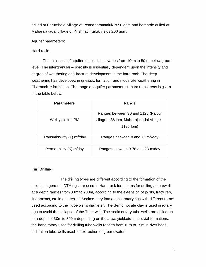
drilled at Perumbalai village of Pennagaramtaluk is 50 gpm and borehole drilled at
Maharajakadai village of Krishnagiritaluk yields 200 gpm.
Aquifer parameters:
Hard rock:
The thickness of aquifer in this district varies from 10 m to 50 m below ground
level. The intergranular – porosity is essentially dependent upon the intensity and
degree of weathering and fracture development in the hard rock. The deep
weathering has developed in gneissic formation and moderate weathering in
Charnockite formation. The range of aquifer parameters in hard rock areas is given
in the table below.
Parameters Range
Well yield in LPM
Ranges between 36 and 1125 (Paiyur
village – 36 lpm, Maharajakadai village –
1125 lpm)
Transmissivity (T) m2/day Ranges between 8 and 73 m2/day
Permeability (K) m/day Ranges between 0.78 and 23 m/day
(iii) Drilling:
The drilling types are different according to the formation of the
terrain. In general, DTH rigs are used in Hard rock formations for drilling a borewell
at a depth ranges from 30m to 200m, according to the extension of joints, fractures,
lineaments, etc in an area. In Sedimentary formations, rotary rigs with different rotors
used according to the Tube well’s diameter. The Bento novate clay is used in rotary
rigs to avoid the collapse of the Tube well. The sedimentary tube wells are drilled up
to a depth of 30m to 300m depending on the area, yield,etc. In alluvial formations,
the hand rotary used for drilling tube wells ranges from 10m to 15m.In river beds,
infiltration tube wells used for extraction of groundwater.

6
In Hard rock, the well designing is simple. The upper top soil and
highly weathered zone is cased with PVC pipe and the remaining weathered,
Fissured, Jointed portion is left as it is. In Villupuram District, the weathered zone
ranges from 1.0m to 12.0m. In Granitic gneiss area, the highly weathered portion will
be more up to 15m but in charnockite area, the weathered zone will extend up to
8.0m to 10.m only. In Sedimentary area, the well construction depends on the
occurrence of sand thickness in the referred area. The logger is also used in the
construction to identify the area of good quality of water.
2. GROUNDWATER REGIME MONITORING:
(i) Notes on existing water level scenario:
The water level is being monitored by State Ground & Surface Water
Resources Data Centre from 1971 onwards from a network of 1746 observation
wells (shallow open wells) located all over the State. The water level readings are
observed in the first week of every month by the field officers. In Dharmapuri District,
184 observation wells and 48 piezometers,totally 232 wells are monitoring on
Monthly basis. The Central Ground Water Board also monitors the water level from
900 numbers of wells spread all over the State. They observe water level four times
in a year. ( i.e January, May, August and November). The collected water level data
are uploaded in GWDES software and database is maintained regularly for analysing
the water level trend with rainfall. From the Monitoring network of wells, the selected
representative wells are taken for Resource Estimation computations.
In Dharmapuri District, during the pre monsoon, the water level generally in
declining trend ranges from G.L. to 15m. The depth of well below GroundLevel
12.0m are become dry during hot season like May, June, July. In the post monsoon,
the water level generally in upward trend due to rainfall and it may reach the Ground
Level also. The water level trend maps for pre and post monsoons are included as
Annexure- I & II.
(ii) Long term trend of water level:
The long term fluctuations of water levels range from G.L. to 14.0m in
many parts of the Dharmapuri District. The analysis reveals that the water level has
gone down in the north, west and central parts of the Dharmapuri District. The
7
inference taken from the annual fluctuation is due to lack of rainfall which in turn
affects the groundwater levels in phreatic aquifer. The seasonal fluctuation study
reveals that due to necessity for development of ground water for different sectored
needs and due to failure of monsoons, the water level has gone down. The
hydrograph of observation wells water level trend from 2005 to 2017 enclosed as
Annexure – III and water level trend from 2000 to 2017 of Piezometers enclosed as
Annexure – IV for Dharmapuri District.
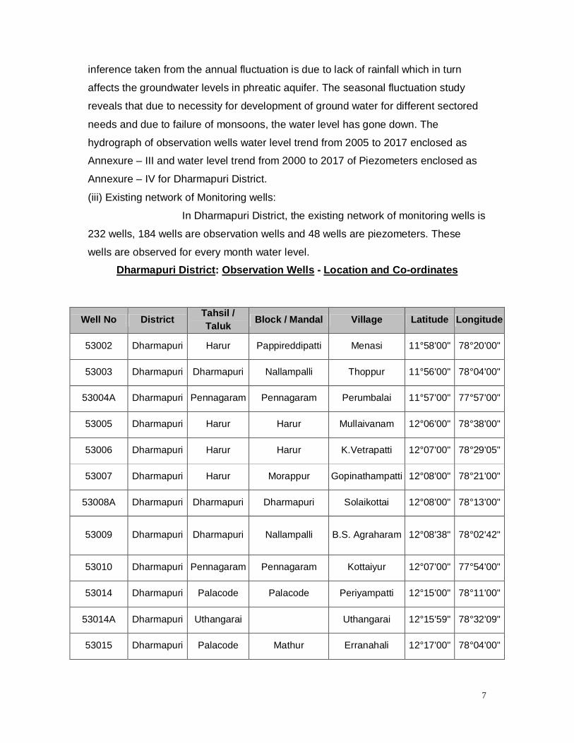
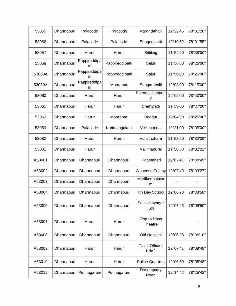
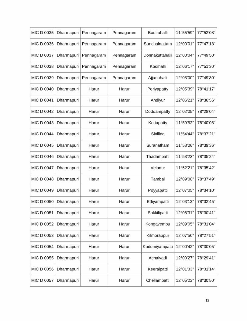
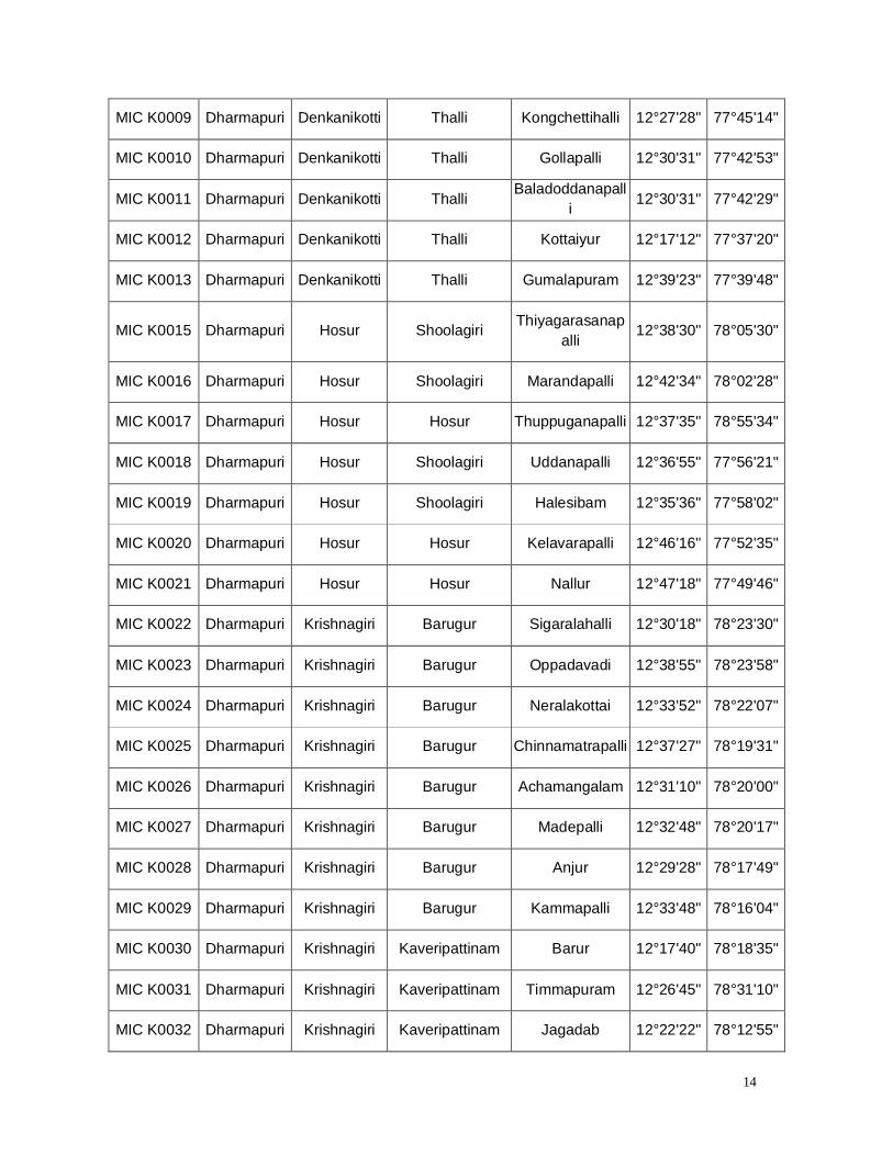
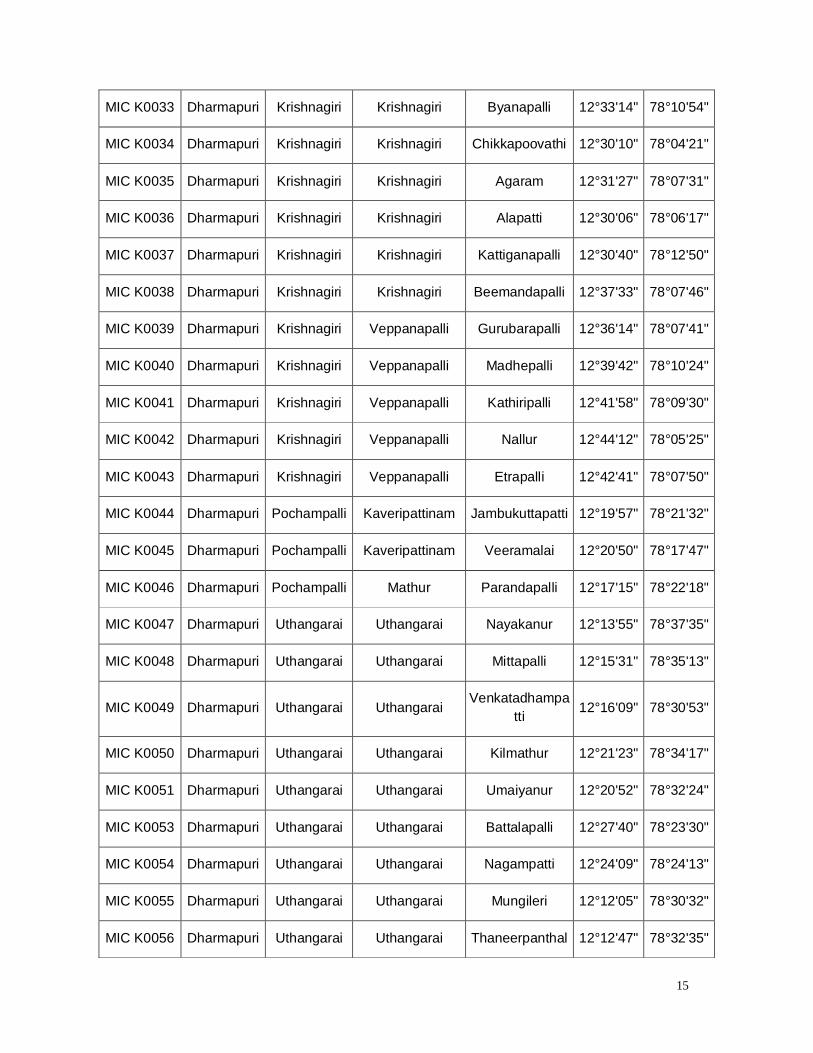
(iii) Existing network of Monitoring wells:
In Dharmapuri District, the existing network of monitoring wells is
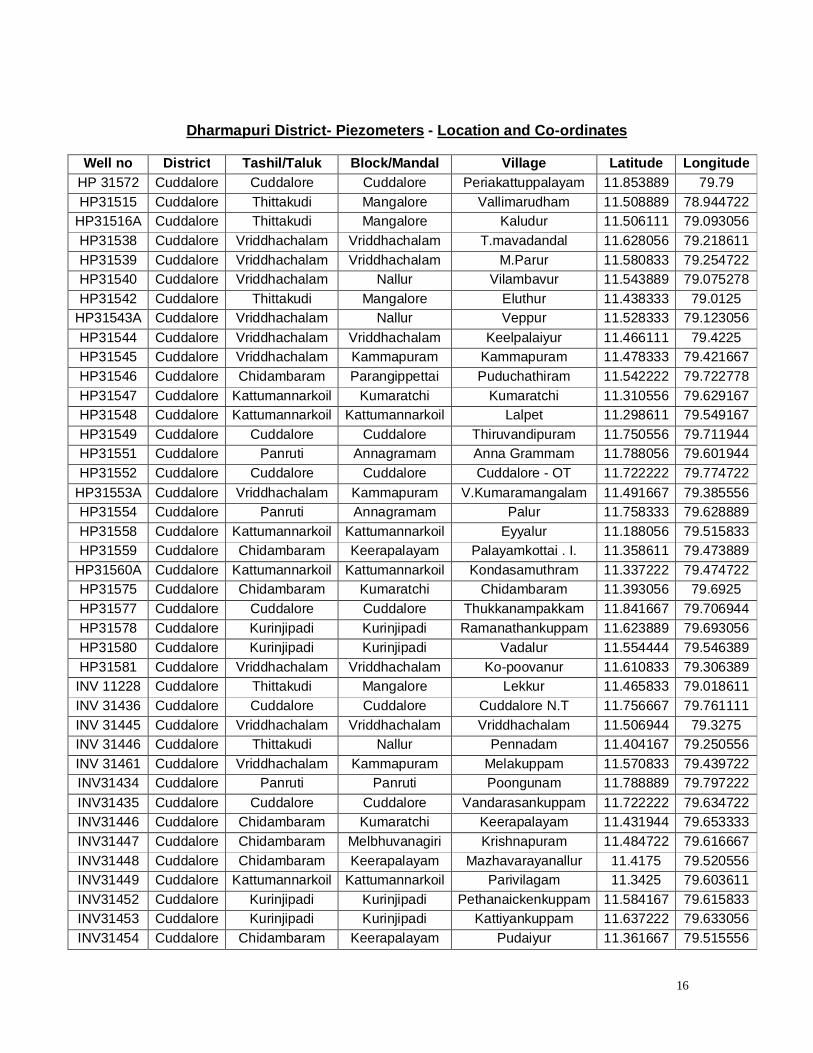
232 wells, 184 wells are observation wells and 48 wells are piezometers. These
wells are observed for every month water level.
Dharmapuri District: Observation Wells - Location and Co-ordinates
Well No District Tahsil / Taluk Block / Mandal Village Latitude Longitude
53002 Dharmapuri Harur Pappireddipatti Menasi 11°58'00" 78°20'00"
53003 Dharmapuri Dharmapuri Nallampalli Thoppur 11°56'00" 78°04'00"
53004A Dharmapuri Pennagaram Pennagaram Perumbalai 11°57'00" 77°57'00"
53005 Dharmapuri Harur Harur Mullaivanam 12°06'00" 78°38'00"
53006 Dharmapuri Harur Harur K.Vetrapatti 12°07'00" 78°29'05"
53007 Dharmapuri Harur Morappur Gopinathampatti 12°08'00" 78°21'00"
53008A Dharmapuri Dharmapuri Dharmapuri Solaikottai 12°08'00" 78°13'00"
53009 Dharmapuri Dharmapuri Nallampalli B.S. Agraharam 12°08'38" 78°02'42"
53010 Dharmapuri Pennagaram Pennagaram Kottaiyur 12°07'00" 77°54'00"
53014 Dharmapuri Palacode Palacode Periyampatti 12°15'00" 78°11'00"
53014A Dharmapuri Uthangarai Uthangarai 12°15'59" 78°32'09"
53015 Dharmapuri Palacode Mathur Erranahali 12°17'00" 78°04'00"

8
53019 Dharmapuri Palacode Karimangalam Periyathobbai 12°25'00" 78°02'00"
53031 Dharmapuri Pappireddipa
tti Pappireddipatti Pappireddipatty 11°54'30" 78°22'30"
53031A Dharmapuri Pappireddipatti Pappireddipatti Pappireddipatty 11°54'30" 78°22'30"
53031AY Dharmapuri Pappireddipatti
Pappireddipatti Pappireddipatty 11°54'30" 78°22'30"
53032 Dharmapuri Pappireddipatti
Pappireddipatti Bommidi 11°59'00" 78°50'30"
53033 Dharmapuri Harur Harur Kottapatti 11°59'00" 78°41'00"
53034 Dharmapuri Harur Harur Harur 12°03'45" 78°28'04"
53035 Dharmapuri Harur Morappur Morappur 12°07'00" 78°23'40"
53036 Dharmapuri Harur Pappireddipatti Kadathur 12°05'10" 78°17'30"
53036A Dharmapuri Pappireddipatti
Morappur Kadathur 12°05'10" 78°17'30"
53037 Dharmapuri Harur Morappur Kambainallur 12°12'00" 78°19'00"
53038 Dharmapuri Palacode Karimangalam Karimangalam 12°18'30" 78°12'30"
53047 Dharmapuri Dharmapuri Nallampalli Narthampatty 12°02'88" 78°07'58"
53048 Dharmapuri Dharmapuri Dharmapuri Kumarasamypettai 12°08'13" 78°09'10"
53049 Dharmapuri Palacode Karimangalam Pulikarai 12°13'45" 78°06'40"
53050 Dharmapuri Pennagaram Pennagaram Papparapatti 12°11'25" 78°02'40"
53050(Ay) Dharmapuri Pennagaram Pennagaram Papparapatti 12°11'25" 78°02'40"
53051A Dharmapuri Pennagaram Pennagaram Nagadasampatty
12°06'20" 77°59'40"
53052 Dharmapuri Pennagaram Pennagaram Pennagaram 12°07'30" 77°54'35"
53053 Dharmapuri Dharmapuri Dharmapuri Krishnapuram 12°12'35" 78°14'15"
53053A Dharmapuri Dharmapuri Dharmapuri Krishnapuram 12°12'12" 78°44'30"
53054 Dharmapuri Palacode Karimangalam Hanumanthapur
am 12°19'50" 78°09'20"
9
53055 Dharmapuri Palacode Palacode Marandahalli 12°22'45" 78°01'20"
53056 Dharmapuri Palacode Palacode Sengodipatti 12°19'52" 78°01'55"
53057 Dharmapuri Harur Harur Sittiling 11°54'00" 78°38'00"
53058 Dharmapuri Pappireddipa
tti Pappireddipatti Salur 11°56'00" 78°26'00"
53058A Dharmapuri Pappireddipatti Pappireddipatti Salur 11°56'00" 78°26'00"
53059A Dharmapuri Pappireddipa
tti Morappur Sungarahalli 12°03'00" 78°15'00"
53060 Dharmapuri Harur Harur Bairanaickanpatt
y 12°02'00" 78°40'00"
53061 Dharmapuri Harur Harur Chettipatti 11°59'00" 78°27'00"
53062 Dharmapuri Harur Morappur Beddur 12°04'00" 78°25'00"
53069 Dharmapuri Palacode Karimangalam Vellichandai 12°21'00" 78°05'00"
53080 Dharmapuri Harur Harur Valaithottam 11°58'50" 78°32'39"
53081 Dharmapuri Harur Vallimadurai 11°58'30" 78°32'22"
A53001 Dharmapuri Dharmapuri Dharmapuri Pidamaneri 12°07'41" 78°08'49"
A53002 Dharmapuri Dharmapuri Dharmapuri Weaver's Colony 12°07'49" 78°09'27"
A53003 Dharmapuri Dharmapuri Dharmapuri Madikonpalayam - -
A53004 Dharmapuri Dharmapuri Dharmapuri 7th Day School 12°06'20" 78°08'58"
A53005 Dharmapuri Dharmapuri Dharmapuri Salaivinayagar
Koil 12°07'43" 78°09'50"
A53007 Dharmapuri Harur Harur Opp.to Dass
Theatre - -
A53008 Dharmapuri Dharmapuri Dharmapuri Old Hospital 12°06'23" 78°08'10"
A53009 Dharmapuri Harur Harur Taluk Office (
Bdo ) 12°07'41" 78°09'48"
A53010 Dharmapuri Harur Harur Police Quarters 12°06'59" 78°08'48"
A53015 Dharmapuri Pennagaram Pennagaram Dasampatty
Road 12°14'42" 78°25'42"

10
A53016 Dharmapuri Pennagaram Pennagaram Vet. Hospital 12°19'19" 78°03'38"
A53017 Dharmapuri Pennagaram Pennagaram Harijan's Colony 13°00'0" 80°06'41"
A53018 Dharmapuri Pennagaram Pennagaram Taluk Office 12°07'49" 78°09'41"
A53019 Dharmapuri Palacode Palacode B.d.o,'s Office 12°08'00" 77°53'48"
A53020 Dharmapuri Palacode Palacode Hosur Road Bridge 12°44'03" 79°49'23"
A53021 Dharmapuri Palacode Palacode Vet. Hospital 12°08'59" 78°31'07"
A53028 Dharmapuri Denkanikotti Denkanikottai Sub-register
Office 12°31'32" 77°47'24"
A53032 Dharmapuri Hosur Hosur Hosur- Near Tank
12°43'47" 77°49'37"
MIC D 0001 Dharmapuri Dharmapuri Dharmapuri Konaginaickanh
alli 12°11'57" 78°11'15"
MIC D 0002 Dharmapuri Dharmapuri Dharmapuri K.naduhalli 12°12'22" 78°12'55"
MIC D 0003 Dharmapuri Dharmapuri Dharmapuri Pulithikarai 12°12'23" 78°16'13"
MIC D 0004 Dharmapuri Dharmapuri Dharmapuri Kondakarahalli 12°00'25" 78°13'55"
MIC D 0005 Dharmapuri Dharmapuri Dharmapuri Veppilaimutham
patti 11°58'52" 78°09'53"
MIC D 0006 Dharmapuri Dharmapuri Nallampalli Kammampatti 11°55'15" 77°57'15"
MIC D 0007 Dharmapuri Dharmapuri Nallampalli Bolanahalli 12°01'45" 78°03'43"
MIC D 0008 Dharmapuri Dharmapuri Nallampalli Maniyathahalli 12°00'05" 78°01'50"
MIC D 0009 Dharmapuri Dharmapuri Nallampalli Elagiri 12°02'00" 78°04'30"
MIC D 0010 Dharmapuri Dharmapuri Dharmapuri Adagapadi 12°08'45" 78°05'21"
MIC D 0011 Dharmapuri Dharmapuri Nallampalli Pangunattam 12°07'56" 78°01'05"
MIC D 0012 Dharmapuri Dharmapuri Nallampalli Errabaiyanahalli 12°05'51" 77°59'17"
MIC D 0013 Dharmapuri Dharmapuri Nallampalli Nagarkudal 12°05'05" 78°03'30"
11
MIC D 0014 Dharmapuri Palacode Palacode Buganahalli 12°11'30" 78°05'25"
MIC D 0015 Dharmapuri Palacode Karimangalam Naganampatti 12°16'50" 78°11'25"
MIC D 0016 Dharmapuri Palacode Karimangalam Bommahalli 12°18'26" 78°10'04"
MIC D 0017 Dharmapuri Palacode Karimangalam Baisuhalli 12°12'46" 78°11'22"
MIC D 0018 Dharmapuri Palacode Karimangalam Hanumanthapuram 12°19'09" 78°06'59"
MIC D 0019 Dharmapuri Palacode Palacode Chikkardanahalli 12°19'12" 78°05'00"
MIC D 0020 Dharmapuri Palacode Palacode P.Settihali 12°19'30" 78°03'05"
MIC D 0021 Dharmapuri Palacode Palacode Senganbasuvant
halav 12°22'31" 78°02'35"
MIC D 0022 Dharmapuri Palacode Palacode Selliyampatti 12°11'10" 78°07'45"
MIC D 0023 Dharmapuri Palacode Palacode Sirenahalli 12°18'08" 77°59'47"
MIC D 0024 Dharmapuri Palacode Palacode Belamaranahalli 12°20'50" 78°00'10"
MIC D 0025 Dharmapuri Palacode Palacode Chinnagoundan
ahalli 12°27'33" 77°59'57"
MIC D 0026 Dharmapuri Palacode Karimangalam Jittandahalli 12°29'08" 78°01'29"
MIC D 0027 Dharmapuri Palacode Palacode Panjapalli 12°29'30" 77°57'34"
MIC D 0028 Dharmapuri Palacode Karimangalam Nammandahalli 12°27'52" 77°58'05"
MIC D 0029 Dharmapuri Palacode Palacode Boppadi 12°17'15" 78°01'15"
MIC D 0030 Dharmapuri Pennagaram Pennagaram Panaikulam 12°13'45" 78°03'45"
MIC D 0031 Dharmapuri Pennagaram Pennagaram Kalappampadi 12°02'17" 77°57'06"
MIC D 0032 Dharmapuri Pennagaram Pennagaram Chinnampalli 12°00'39" 77°57'56"
MIC D 0033 Dharmapuri Pennagaram Pennagaram Sathyanathapur
am 12°06'27" 77°54'43"
MIC D 0034 Dharmapuri Pennagaram Pennagaram Gendanahalli 11°55'26" 77°55'12"
12
MIC D 0035 Dharmapuri Pennagaram Pennagaram Badirahalli 11°55'59" 77°52'08"
MIC D 0036 Dharmapuri Pennagaram Pennagaram Sunchalnattam 12°00'01" 77°47'18"
MIC D 0037 Dharmapuri Pennagaram Pennagaram Donnakuttahalli 12°00'04" 77°49'50"
MIC D 0038 Dharmapuri Pennagaram Pennagaram Kodihalli 12°06'17" 77°51'30"
MIC D 0039 Dharmapuri Pennagaram Pennagaram Ajjanahalli 12°03'00" 77°49'30"
MIC D 0040 Dharmapuri Harur Harur Periyapatty 12°05'39" 78°41'17"
MIC D 0041 Dharmapuri Harur Harur Andiyur 12°06'21" 78°36'56"
MIC D 0042 Dharmapuri Harur Harur Doddampatty 12°02'05" 78°28'04"
MIC D 0043 Dharmapuri Harur Harur Kottapatty 11°59'52" 78°40'05"
MIC D 0044 Dharmapuri Harur Harur Sittiling 11°54'44" 78°37'21"
MIC D 0045 Dharmapuri Harur Harur Suranatham 11°58'06" 78°39'36"
MIC D 0046 Dharmapuri Harur Harur Thadampatti 11°53'23" 78°35'24"
MIC D 0047 Dharmapuri Harur Harur Velanur 11°52'21" 78°35'42"
MIC D 0048 Dharmapuri Harur Harur Tambal 12°09'00" 78°37'49"
MIC D 0049 Dharmapuri Harur Harur Poyyapatti 12°07'05" 78°34'10"
MIC D 0050 Dharmapuri Harur Harur Ettiyampatti 12°03'13" 78°32'45"
MIC D 0051 Dharmapuri Harur Harur Sakkilipatti 12°08'31" 78°30'41"
MIC D 0052 Dharmapuri Harur Harur Kongavembu 12°09'05" 78°31'04"
MIC D 0053 Dharmapuri Harur Harur Kilmorappur 12°07'56" 78°27'51"
MIC D 0054 Dharmapuri Harur Harur Kudumiyampatti 12°00'42" 78°30'05"
MIC D 0055 Dharmapuri Harur Harur Achalvadi 12°00'27" 78°29'41"
MIC D 0056 Dharmapuri Harur Harur Keeraipatti 12°01'33" 78°31'14"
MIC D 0057 Dharmapuri Harur Harur Chellampatti 12°05'23" 78°30'50"

13
MIC D 0058 Dharmapuri Harur Morappur Agraharam 12°11'55" 78°22'21"
MIC D 0059 Dharmapuri Harur Morappur Navalai 12°10'22" 78°21'59"
MIC D 0060 Dharmapuri Harur Morappur Echampadi 12°13'11" 78°21'34"
MIC D 0061 Dharmapuri Harur Morappur Kambainallur 12°12'43" 78°19'44"
MIC D 0062 Dharmapuri Pappireddipatti Morappur Ramiyanahalli 12°02'18" 78°22'45"
MIC D 0063 Dharmapuri Pappireddipa
tti Morappur Tenkaraikottai 12°00'48" 78°23'46"
MIC D 0064 Dharmapuri Pappireddipatti
Morappur Buddireddipatti 12°04'19" 78°17'56"
MIC D 0065 Dharmapuri Pappireddipa
tti Morappur Kedagarahalli 12°04'53" 78°16'11"
MIC D 0066 Dharmapuri Pappireddipatti
Morappur Buddireddipatti 12°03'07" 78°18'12"
MIC D 0067 Dharmapuri Pappireddipatti
Pappireddipatti Alapuram 11°58'13" 78°23'44"
MIC D 0068 Dharmapuri Pappireddipatti Pappireddipatti Venkatasamudr
am 11°55'37" 78°21'02"
MIC D 0069 Dharmapuri Pappireddipa
tti Pappireddipatti Bairnattam 11°56'44" 78°17'58"
MIC D 0070 Dharmapuri Pappireddipa
tti Pappireddipatti Pattukonampatti 11°52'43" 78°22'01"
MIC D 0071 Dharmapuri Pappireddipatti Pappireddipatti Adigarapatti 11°56'13" 78°23'31"
MIC D 0072 Dharmapuri Pappireddipatti
Pappireddipatti Pudupatti 11°58'00" 78°24'58"
MIC K0001 Dharmapuri Denkanikotti Kelamangalam Biddireddy 12°38'58" 77°49'44"
MIC K0002 Dharmapuri Denkanikotti Thalli Vanamangalam 12°36'47" 77°45'43"
MIC K0003 Dharmapuri Denkanikotti Thalli Thallikothanur 12°34'41" 77°41'13"
MIC K0004 Dharmapuri Denkanikotti Thalli Marupalli 12°33'19" 77°38'34"
MIC K0005 Dharmapuri Denkanikotti Thalli Thalli 12°35'05" 77°39'45"
MIC K0006 Dharmapuri Denkanikotti Thalli Ballaplli 12°32'38" 77°42'41"
MIC K0007 Dharmapuri Denkanikotti Thalli Kakkadasam 12°34'04" 77°43'27"
MIC K0008 Dharmapuri Denkanikotti Thalli Anchetty 12°21'18" 77°42'54"
14
MIC K0009 Dharmapuri Denkanikotti Thalli Kongchettihalli 12°27'28" 77°45'14"
MIC K0010 Dharmapuri Denkanikotti Thalli Gollapalli 12°30'31" 77°42'53"
MIC K0011 Dharmapuri Denkanikotti Thalli Baladoddanapall
i 12°30'31" 77°42'29"
MIC K0012 Dharmapuri Denkanikotti Thalli Kottaiyur 12°17'12" 77°37'20"
MIC K0013 Dharmapuri Denkanikotti Thalli Gumalapuram 12°39'23" 77°39'48"
MIC K0015 Dharmapuri Hosur Shoolagiri Thiyagarasanapalli
12°38'30" 78°05'30"
MIC K0016 Dharmapuri Hosur Shoolagiri Marandapalli 12°42'34" 78°02'28"
MIC K0017 Dharmapuri Hosur Hosur Thuppuganapalli 12°37'35" 78°55'34"
MIC K0018 Dharmapuri Hosur Shoolagiri Uddanapalli 12°36'55" 77°56'21"
MIC K0019 Dharmapuri Hosur Shoolagiri Halesibam 12°35'36" 77°58'02"
MIC K0020 Dharmapuri Hosur Hosur Kelavarapalli 12°46'16" 77°52'35"
MIC K0021 Dharmapuri Hosur Hosur Nallur 12°47'18" 77°49'46"
MIC K0022 Dharmapuri Krishnagiri Barugur Sigaralahalli 12°30'18" 78°23'30"
MIC K0023 Dharmapuri Krishnagiri Barugur Oppadavadi 12°38'55" 78°23'58"
MIC K0024 Dharmapuri Krishnagiri Barugur Neralakottai 12°33'52" 78°22'07"
MIC K0025 Dharmapuri Krishnagiri Barugur Chinnamatrapalli 12°37'27" 78°19'31"
MIC K0026 Dharmapuri Krishnagiri Barugur Achamangalam 12°31'10" 78°20'00"
MIC K0027 Dharmapuri Krishnagiri Barugur Madepalli 12°32'48" 78°20'17"
MIC K0028 Dharmapuri Krishnagiri Barugur Anjur 12°29'28" 78°17'49"
MIC K0029 Dharmapuri Krishnagiri Barugur Kammapalli 12°33'48" 78°16'04"
MIC K0030 Dharmapuri Krishnagiri Kaveripattinam Barur 12°17'40" 78°18'35"
MIC K0031 Dharmapuri Krishnagiri Kaveripattinam Timmapuram 12°26'45" 78°31'10"
MIC K0032 Dharmapuri Krishnagiri Kaveripattinam Jagadab 12°22'22" 78°12'55"
15
MIC K0033 Dharmapuri Krishnagiri Krishnagiri Byanapalli 12°33'14" 78°10'54"
MIC K0034 Dharmapuri Krishnagiri Krishnagiri Chikkapoovathi 12°30'10" 78°04'21"
MIC K0035 Dharmapuri Krishnagiri Krishnagiri Agaram 12°31'27" 78°07'31"
MIC K0036 Dharmapuri Krishnagiri Krishnagiri Alapatti 12°30'06" 78°06'17"
MIC K0037 Dharmapuri Krishnagiri Krishnagiri Kattiganapalli 12°30'40" 78°12'50"
MIC K0038 Dharmapuri Krishnagiri Krishnagiri Beemandapalli 12°37'33" 78°07'46"
MIC K0039 Dharmapuri Krishnagiri Veppanapalli Gurubarapalli 12°36'14" 78°07'41"
MIC K0040 Dharmapuri Krishnagiri Veppanapalli Madhepalli 12°39'42" 78°10'24"
MIC K0041 Dharmapuri Krishnagiri Veppanapalli Kathiripalli 12°41'58" 78°09'30"
MIC K0042 Dharmapuri Krishnagiri Veppanapalli Nallur 12°44'12" 78°05'25"
MIC K0043 Dharmapuri Krishnagiri Veppanapalli Etrapalli 12°42'41" 78°07'50"
MIC K0044 Dharmapuri Pochampalli Kaveripattinam Jambukuttapatti 12°19'57" 78°21'32"
MIC K0045 Dharmapuri Pochampalli Kaveripattinam Veeramalai 12°20'50" 78°17'47"
MIC K0046 Dharmapuri Pochampalli Mathur Parandapalli 12°17'15" 78°22'18"
MIC K0047 Dharmapuri Uthangarai Uthangarai Nayakanur 12°13'55" 78°37'35"
MIC K0048 Dharmapuri Uthangarai Uthangarai Mittapalli 12°15'31" 78°35'13"
MIC K0049 Dharmapuri Uthangarai Uthangarai Venkatadhampa
tti 12°16'09" 78°30'53"
MIC K0050 Dharmapuri Uthangarai Uthangarai Kilmathur 12°21'23" 78°34'17"
MIC K0051 Dharmapuri Uthangarai Uthangarai Umaiyanur 12°20'52" 78°32'24"
MIC K0053 Dharmapuri Uthangarai Uthangarai Battalapalli 12°27'40" 78°23'30"
MIC K0054 Dharmapuri Uthangarai Uthangarai Nagampatti 12°24'09" 78°24'13"
MIC K0055 Dharmapuri Uthangarai Uthangarai Mungileri 12°12'05" 78°30'32"
MIC K0056 Dharmapuri Uthangarai Uthangarai Thaneerpanthal 12°12'47" 78°32'35"
16
Dharmapuri District- Piezometers - Location and Co-ordinates
Well no District Tashil/Taluk Block/Mandal Village Latitude Longitude HP 31572 Cuddalore Cuddalore Cuddalore Periakattuppalayam 11.853889 79.79 HP31515 Cuddalore Thittakudi Mangalore Vallimarudham 11.508889 78.944722
HP31516A Cuddalore Thittakudi Mangalore Kaludur 11.506111 79.093056 HP31538 Cuddalore Vriddhachalam Vriddhachalam T.mavadandal 11.628056 79.218611 HP31539 Cuddalore Vriddhachalam Vriddhachalam M.Parur 11.580833 79.254722 HP31540 Cuddalore Vriddhachalam Nallur Vilambavur 11.543889 79.075278 HP31542 Cuddalore Thittakudi Mangalore Eluthur 11.438333 79.0125
HP31543A Cuddalore Vriddhachalam Nallur Veppur 11.528333 79.123056 HP31544 Cuddalore Vriddhachalam Vriddhachalam Keelpalaiyur 11.466111 79.4225 HP31545 Cuddalore Vriddhachalam Kammapuram Kammapuram 11.478333 79.421667 HP31546 Cuddalore Chidambaram Parangippettai Puduchathiram 11.542222 79.722778 HP31547 Cuddalore Kattumannarkoil Kumaratchi Kumaratchi 11.310556 79.629167 HP31548 Cuddalore Kattumannarkoil Kattumannarkoil Lalpet 11.298611 79.549167 HP31549 Cuddalore Cuddalore Cuddalore Thiruvandipuram 11.750556 79.711944 HP31551 Cuddalore Panruti Annagramam Anna Grammam 11.788056 79.601944 HP31552 Cuddalore Cuddalore Cuddalore Cuddalore - OT 11.722222 79.774722
HP31553A Cuddalore Vriddhachalam Kammapuram V.Kumaramangalam 11.491667 79.385556 HP31554 Cuddalore Panruti Annagramam Palur 11.758333 79.628889 HP31558 Cuddalore Kattumannarkoil Kattumannarkoil Eyyalur 11.188056 79.515833 HP31559 Cuddalore Chidambaram Keerapalayam Palayamkottai . I. 11.358611 79.473889
HP31560A Cuddalore Kattumannarkoil Kattumannarkoil Kondasamuthram 11.337222 79.474722 HP31575 Cuddalore Chidambaram Kumaratchi Chidambaram 11.393056 79.6925 HP31577 Cuddalore Cuddalore Cuddalore Thukkanampakkam 11.841667 79.706944 HP31578 Cuddalore Kurinjipadi Kurinjipadi Ramanathankuppam 11.623889 79.693056 HP31580 Cuddalore Kurinjipadi Kurinjipadi Vadalur 11.554444 79.546389 HP31581 Cuddalore Vriddhachalam Vriddhachalam Ko-poovanur 11.610833 79.306389
INV 11228 Cuddalore Thittakudi Mangalore Lekkur 11.465833 79.018611 INV 31436 Cuddalore Cuddalore Cuddalore Cuddalore N.T 11.756667 79.761111 INV 31445 Cuddalore Vriddhachalam Vriddhachalam Vriddhachalam 11.506944 79.3275 INV 31446 Cuddalore Thittakudi Nallur Pennadam 11.404167 79.250556 INV 31461 Cuddalore Vriddhachalam Kammapuram Melakuppam 11.570833 79.439722 INV31434 Cuddalore Panruti Panruti Poongunam 11.788889 79.797222 INV31435 Cuddalore Cuddalore Cuddalore Vandarasankuppam 11.722222 79.634722 INV31446 Cuddalore Chidambaram Kumaratchi Keerapalayam 11.431944 79.653333 INV31447 Cuddalore Chidambaram Melbhuvanagiri Krishnapuram 11.484722 79.616667 INV31448 Cuddalore Chidambaram Keerapalayam Mazhavarayanallur 11.4175 79.520556 INV31449 Cuddalore Kattumannarkoil Kattumannarkoil Parivilagam 11.3425 79.603611 INV31452 Cuddalore Kurinjipadi Kurinjipadi Pethanaickenkuppam 11.584167 79.615833 INV31453 Cuddalore Kurinjipadi Kurinjipadi Kattiyankuppam 11.637222 79.633056 INV31454 Cuddalore Chidambaram Keerapalayam Pudaiyur 11.361667 79.515556

17
INV31455 Cuddalore Chidambaram Keerapalayam Koodalaiyathur 11.415278 79.470278 INV31456 Cuddalore Chidambaram Kumaratchi Thuniseramedu 11.376389 79.655278 INV31457 Cuddalore Chidambaram Melbhuvanagiri Kiliyanur 11.424722 79.590278 INV31462 Cuddalore Thittakudi Mangalore Alambadi 11.459444 79.061389 INV31463 Cuddalore Thittakudi Mangalore Vinayaganandal 11.518056 79.04
MWS 31582
Cuddalore Panruti Panruti Marungur 11.655 79.535278
MWS 31585 Cuddalore Panruti Panruti Thiruvamur 11.768056 79.478333
(iv) Data Constraints:
The following are constraints in collecting the water level data in the
field and validating the data are:
1) The water level data are collected on the monthly basis in the referred
observation wells and piezometers. The collected data is not sufficient quantity
for analyzing purpose due to drying of wells, Wells abounded by various
reasons, lack of selecting the alternate wells, lack of open wells available for
monitoring purpose due to increased usage of bore wells in the villages,
Panchayats, etc. In many villages, the water supply schemes implemented by
overhead tank supply or mini energised pumps and the existing open wells are
not used generally by the villagers and moreover, they filled with garbage.
2) The number of bore wells should be increased for monitoring purpose.
3) The site selection of new bore wells should be based on the Geological
methods.
4) Strengthening the network of monitoring wells by closing the gaps in the
network.
5) Maintenance cost should be allotted to maintain the bore wells on the periodical
basis to maintain the quality as well as yield.
6) Installation of Automatic water level recorders in the sensitive and more water
level fluctuation in the bore wells will helpful to monitor the extensive depletion of
groundwater areas.
7) Upgrading the measuring instruments will helpful to take accurate reading of
water levels in the field.
8) Upgrading the soft ware will helpful to minimize the errors and increasing the
accuracy of data.

18
9) Erecting the Telemetric water level recorders in the over exploited Firkas will
helpful to monitor the over extraction of groundwater.
10)Lack of manpower and transporting vehicles are also major problems for data
collection in the field in proper time.
3. DYNAMIC GROUND WATER RESOURCES:
The State Ground and Surface Water Resources Data Centre has
estimated the ground water resources of Tamil Nadu periodically in co-ordination
with the Central Ground Water Board, Government of India , Ministry of Water
Resources, Chennai, based on the Methodology evolved by the Ground Water
Resources Estimation Committee, 1997 (GEC 97).
Groundwater potential assessment is a dynamic one and not static.
While assessing an area, the following factors can be considered such as Geology,
Total Irrigated Area, Total Number of Wells used for Irrigation, Water Level Data for
the past five years, Average Rainfall, Total Recharge, Irrigation methods adopted in
the area, Cropping pattern details, Seepage factor, Specific yield, Geological
conditions prevailing in that area, Recharge through Artificial recharge structures,
etc.
Groundwater potential assessment proposal should be presented
for approval in the Central and State Level Working Group Committees and then,
presented for final approval in the Central Level Committee as well as State Level
Committees.
The Ground Water Potential Assessments as on January 1992 and January 1997 were done in the State, taking the Panchayat Union Block
as an Assessment Unit and the entire State was categorized as Dark, Grey and
White areas. The Blocks with more than 85% to 100% ground water development
(extraction) were categorized as “Dark Blocks” and the blocks with ground water
development between 65% to 85% were categorized as “Grey Blocks” and blocks
with less than 65% ground water development were categorized as “White Blocks”.
Subsequently, the Ground Water Potential Assessment was done as on March 2003 and as on March 2009. In these assessments, the

19
Panchayat Union Blocks in Tamil Nadu were categorized as Over-Exploited, Critical, Semi-Critical, Safe and Saline instead of Dark, Grey and White blocks.
The Blocks with more than 100% extraction were categorized as “Over Exploited
Blocks”, the blocks with 90% to 100% extraction as “Critical Blocks”, the blocks with
65% to 90% extraction as “Semi Critical Blocks”, the blocks with less than 65%
extraction as “Safe Blocks” and the bad quality blocks were categorized as “Saline
Blocks”. No schemes should be formulated in over exploited and critical blocks -
“Notified Blocks – A category – (Stage of Groundwater extraction is 90% and
above)”.
The re-estimation of groundwater resources in the State as on
March 2011 and as on March 2013 can be assessed in Micro Level basis. In these
assessments, the assessing unit is Firka ( Unit of Taluk) and categorized as Over-
Exploited, Critical, Semi-Critical, Safe, and Saline Firkas. As on March 2013
assessment, in the Dharmapuri District
Based on the Estimation of Ground Water Resources of Tamil
Nadu State as on March 2013, Out of 1139 Firkas in the State, 358 Firkas are
categorized as “Over Exploited Firkas”, 105 Firkas are categorized as “Critical
Firkas”, 212 Firkas are categorized as “Semi Critical Firkas”, 429 Firkas are
categorized as “Safe Firkas” and 35 Firkas are categorized as “Saline Firkas”.
When compared to last assessment as on March 2011, the “Over
Exploited Firkas” comes down from 374 to 358 Firkas, the “Critical Firkas” increased
from 48 to 105 Firkas, the “Semi Critical Firkas” comes down marginally from 235 to
212 Firkas, the “Safe Firkas” comes down marginally from 437 to 429 Firkas and the
“Saline Firkas” remains same as 35 Firkas. The alteration of Firkas are due to the
construction of Artificial Recharge structures such as Check Dams, Recharge Wells,
Recharge shafts, percolation ponds; etc was constructed in the “Over Exploited
Firkas” by various departments.
Methodology adopted for Estimation of Ground Water Potential :
The present methodology used for resources assessment is
known as Ground Water Resource Estimation Methodology - 1997 (GEC'97) .In
GEC'97, two approaches are recommended - water level fluctuation method and norms of rainfall infiltration method. The water level fluctuation method is based
20
on the concept of storage change due to differences between various input and
output components. Input refers to recharge from rainfall and other sources and
subsurface inflow into the unit of assessment. Output refers to ground water draft,
ground water evapotranspiration, base flow to streams and subsurface outflow from
the unit. Since the data on subsurface inflow / outflow are not readily available, it is
advantageous to adopt the unit for ground water assessment as basin / sub basin /
watershed, as the inflow / outflow across these boundaries may be taken as
negligible.
In each assessment unit, hilly areas having slope more than 20% are
deleted from the total area to get the area suitable for recharge. Further, areas
where the quality of ground water is beyond the usable limits should be identified
and handled separately. The remaining area after deleting the hilly area and
separating the area with poor ground water quality is to be delineated into command
and non-command areas. Ground water assessment in command and non-
command areas are done separately for monsoon and non-monsoon seasons.
The rainfall recharge during monsoon season computed by Water Level
Fluctuation (WLF) method is compared with recharge figures from Rainfall Infiltration
Factor (RIF) method. In case the difference between the two sets of data are more
than 20% then RIF figure is considered, otherwise monsoon recharge from WLF is
adopted. While adopting the rainfall recharge figures, weight age is to be given to
WLF method over adhoc norms method of RIF. Hence, wherever the difference
between RIF & WLF is more than 20%, data have to be scrutinized and corrected
accordingly.
During non-Monsoon season, rainfall recharge is computed by using
Rainfall infiltration Factor (RIF) method. Recharge from other sources is then added
to get total non-Monsoon recharge. In case of areas receiving less than 10% of the
annual rainfall during non-monsoon season, the rainfall recharge is ignored.
The total annual ground water recharge of the area is the sum-total
of monsoon and non-monsoon recharge. An allowance is kept for natural discharge
in the non-monsoon season by deducting 5 to 10 % of total annual ground water
recharge.
The balance ground water available accounts for existing ground
water withdrawal for various uses and potential for future development. This quantity
is termed as Net Ground Water Availability.
21
Net Ground Water Availability = Annual Ground Water Recharge - Natural discharge
during non-monsoon season.
GEC'97 methodology has recommended norms for various
parameters being used in ground water recharge estimation. These norms vary
depending upon water bearing formations and agroclimatic conditions. While norms
for specific yield and recharge from rainfall values are to be adopted within the
guidelines of GEC'97, in case of other parameters like seepage from canals, return
flow from irrigation, recharge from tanks & ponds, water conservation structures,
results of specific case studies may replace the adhoc norms.
The Gross yearly ground water draft is to be calculated for
Irrigation, Domestic and Industrial uses. The gross ground water draft would include
the ground water extraction from all existing ground water structures during monsoon
as well as during non-monsoon period. While the number of ground water structures
should preferably be based on latest well census, the average unit draft from
different types of structures should be based on specific studies or adhoc norms
given in GEC'97 report.
The stage of Ground water Development is defined by
Stage of Ground water = Existing Gross Ground water Draft for all uses X 100 Development (%) Net annual Ground Water Availability
The units of assessment are categorized for ground water development
based on two criteria – a) stage of ground water development and b) long-term trend
of pre and post monsoon water levels. Four categories are - Safe areas which have
ground water potential for development; Semi-critical areas where cautious ground
water development
is recommended; Critical areas; Over -exploited areas where there should be
intensive monitoring and evaluation and future ground water development be linked
with water conservation measures.
The criteria for categorization of assessment units are as follows:
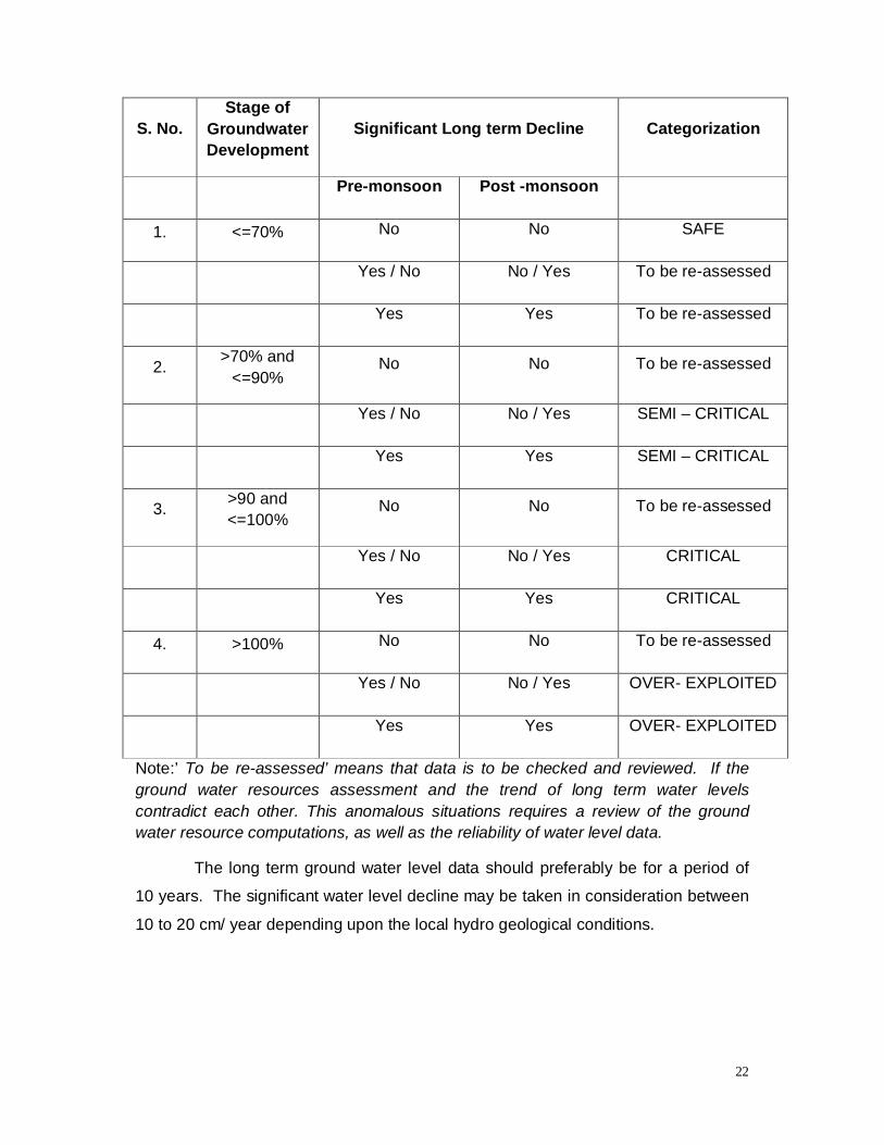
22
S. No. Stage of
Groundwater Development
Significant Long term Decline Categorization
Pre-monsoon Post -monsoon
1. <=70% No No SAFE
Yes / No No / Yes To be re-assessed
Yes Yes To be re-assessed
2. >70% and <=90%
No No To be re-assessed
Yes / No No / Yes SEMI – CRITICAL
Yes Yes SEMI – CRITICAL
3. >90 and <=100%
No No To be re-assessed
Yes / No No / Yes CRITICAL
Yes Yes CRITICAL
4. >100% No No To be re-assessed
Yes / No No / Yes OVER- EXPLOITED
Yes Yes OVER- EXPLOITED
Note:’ To be re-assessed’ means that data is to be checked and reviewed. If the ground water resources assessment and the trend of long term water levels contradict each other. This anomalous situations requires a review of the ground water resource computations, as well as the reliability of water level data.
The long term ground water level data should preferably be for a period of
10 years. The significant water level decline may be taken in consideration between
10 to 20 cm/ year depending upon the local hydro geological conditions.

23
Dynamic Ground Water Resources Estimation of TamilNadu As on March 2013 District Summary
( in ha.m )
DHARMAPURI DISTRICT
Sl.N
o ( D
istr
ict))
District Net Annual
Ground Water
Availability
Existing Gross
Ground Water
Draft for Irrigation
Existing Gross
Ground Water
Draft for domestic
and industrial
water supply
Existing Gross
Ground Water
Draft for All uses
(4+5)
Stage of Ground Water Development
{(6/3)*100} %
No of Over
Exploited Firkas
1 2 3 4 5 6 7 8
1 DHARMAPURI 36,669.66 45,262.44 1,903.07 47,165.51 129 14
Firka Wise Summary (in ha.m)
SI.No
Assessment Unit
(Firka)
Net Annual Ground Water
Availability
Existing Gross
Ground Water
Draft for Irrigation
Existing Gross
Ground Water
Draft for domestic
and industrial
water supply
Existing Gross
Ground Water
Draft for All uses
(4+5)
Stage of Ground Water
Development {(6/3)*100}
%
Category of the Firka
1 BOMMIDI 2,076.75 2,944.35 93.72 3,038.07 146 OVER EXPLOITED
2 DHARMAPURI 1,766.57 1,326.74 144.66 1,471.40 83 SEMI CRITICAL
3 HARUR 2,559.54 2,097.85 92.44 2,190.29 86 SEMI CRITICAL
4 INDUR 1,145.81 1,954.63 81.74 2,036.37 178 OVER EXPLOITED
5 KADATHUR 1,477.86 2,287.48 48.76 2,336.24 158 OVER EXPLOITED
6 KAMBAINALLUR 1,462.55 1,931.38 49.66 1,981.03 135 OVER EXPLOITED
7 KARIMANGALAM 1,822.48 3,836.10 89.36 3,925.46 215 OVER EXPLOITED

24
DHARMAPURI DISTRICT
SI.No
Assessment Unit
(Firka)
Net Annual Ground Water
Availability
Existing Gross
Ground Water
Draft for Irrigation
Existing Gross
Ground Water
Draft for domestic
and industrial
water supply
Existing Gross
Ground Water
Draft for All uses
(4+5)
Stage of Ground Water
Development {(6/3)*100}
%
Category of the Firka
8 KRISHNAPURAM 1,610.37 1,260.60 66.54 1,327.14 82 SEMI CRITICAL
9 MARANDAHALLI 1,254.49 2,373.80 53.56 2,427.36 193 OVER EXPLOITED
10 MORAPPUR 1,825.94 1,612.00 72.72 1,684.72 92 CRITICAL
11 NALLAMPALLI 1,053.62 882.65 90.31 972.96 92 CRITICAL
12 PALACODE 2,254.79 3,108.45 89.34 3,197.79 142 OVER EXPLOITED
13 PALAYAM 1,081.78 1,862.75 75.32 1,938.07 179 OVER EXPLOITED
14 PAPPARAPATTY 1,336.59 1,719.38 84.13 1,803.51 135 OVER EXPLOITED
15 PAPPIREDDIPATTY 1,924.14 1,633.24 141.16 1,774.40 92 CRITICAL
16 PENNAGARAM 1,228.23 1,983.00 75.01 2,058.01 168 OVER EXPLOITED
17 PERUMBALAI 551.14 1,077.80 45.37 1,123.16 204 OVER EXPLOITED
18 PULIKARAI 2,051.25 3,313.00 75.74 3,388.74 165 OVER EXPLOITED
19 SUNJALNATHAM 1,135.36 862.89 54.37 917.26 81 SEMI CRITICAL
20 THEERTHAMALAI 3,850.68 2,875.75 197.58 3,073.33 80 SEMI CRITICAL
21 THENKARAIKOTTAI 1,648.41 2,521.10 89.92 2,611.02 158 OVER EXPLOITED
22 VELLICHANDAI 1,551.30 1,797.53 91.66 1,889.19 122 OVER EXPLOITED
TOTAL 36,669.66 45,262.44 1,903.07 47,165.51 129
4. Groundwater quality issues:
The rainfall is the main source for the availability of water both in
surface and sub surface. The quantum of rainfall varies every year depending upon
the monsoon. However, the extraction of surface and sub surface water is increasing
year by year. It leads to environmental impact on the water sources like depletion of
water level, deterioration of water quality. It makes the demand for the quantification
of available water and also its quality for various purposes like agriculture, industries,
drinking and domestic purposes.

25
For the present assessment, the value of Total Dissolved Solids (TDS)
have been considered for demarcation of good / bad quality areas. For this purpose,
the TDS value of less than or equal to 2000 mg/l have been considered as good
quality and the value more than 2000 mg/l have been considered as bad quality
areas.
The presence of fluoride in natural Ground Water is having its merits and
demerits depending upon the concentration. Presence of fluoride <1.0 mg/l in
drinking water reduces dental diseases whereas higher level > 1.50 mg/l will affect
the health and causes dental fluoridise. Nitrate is noted significantly in Ground Water
due to use of chemical fertilizer for agriculture and other local pollution rocks and
soils are also contributing nitrate to Ground Water. Arsenic is another poisonous
heavy metal in Ground Water. The allowable limits for drinking purposes are 0.05
mg/l.
In Dharmapuri District, the quality of Ground Water generally ranges from
moderate to good quality both in the shallow dug well and bore wells except in &
around the Kazhuveli tank, where the water quality is poor due to seawater intrusion
in the lagoons during high tide seasons, the production of salt and Aquaculture
farming.
5. Groundwater issues and challenges:
The groundwater quantity and quality are to be highlighted and may be analyzed in terms of :
(i)Problems posed by nature:
In terms of Quantitative aspects, nowadays, rainfall may more within the short period of duration. Due to this aspect, recharge is less and runoff will be more. The availability of groundwater is less due to over extraction than recharge. The Percentage of OE/Critical Firkas increased due to this reason. Increasing the artificial recharge structures in the proper areas may avoid the depletion of groundwater especially in OE/Critical Firkas.
(ii) Problems caused by anthropogenic activities:
The problems caused due to intensive groundwater extraction, intensive surface water irrigation, intensive mining activities, growing urban complexes and industrial establishments will lead to drastic depletion in groundwater resources only. Proper alternative recharge structures must be established.
26
(iii) Problems caused by socio-economic condition:
The land holdings of farmers may be different from another. One farmer having more than 5 Acres has less expense than a farmer having one acre. The free electric supply to all farmers have chance to extract more groundwater. To avoid this, proper guidance will be given to the farmers for the usage of groundwater.
(iv) Administrative issues:
To control, regulate and manage the Ground Water Resources in the
State, there is no groundwater act, now in force. But, the Chennai Metropolitan Area Ground Water (Regulation) Act, 1987 is in force and it extends to Chennai
City and notified 302 revenue villages in Kanchipuram and Thiruvallur Districts, only.
The rest of Tamilnadu, G.O.(Ms).No.142, Public Works (R2) Department, dated: 23.07.2014 and G.O.(Ms).No.113, Public Works (R2) Dept , Dt:09.06.2016 are regulate and manage the groundwater resources. The
Government of Tamil Nadu had enacted the Tamil Nadu Ground Water
(Development and Management) Act, 2003. However, this Act was repealed on 14.09.2013, in order to enact a comprehensive law to develop and manage the
groundwater in the changed scenario in the State.
The pricing policy for groundwater users is also an important
strategy in controlling the illegal extraction of groundwater by taking from lorries,etc.
The unused dug wells and bore wells can be used as artificial recharge structures
will be good concept in recharging the ground water.
6. Groundwater Management and Regulations:
(i) Statute/Law/Policy/Regulations if any:
The Central Ground Water Authority has been constituted to
regulate, control, development and management of ground water resources for
whole country based on overall situation prevailing in India. But, the ground water
conditions are varying from State to State. Ground Water is a State subject and the State Government has every right to protect and regulate their own precious ground water resources according to the prevailing conditions in the State.

27
The Tamil Nadu Government had enacted “The Tamil Nadu Ground Water (Development and Management) Act, 2003” which was
subsequently repealed in 2013, so as to bring out an effective management Act
considering the present scenario. As an interim measure, for regulating the exploitation of ground water, the Government have issued G.O. (Ms) No.142,PWD dated 23.07.2014 for regulations for management of ground water for safe guarding the scarce groundwater resources in Tamil Nadu State. In the
absence of an Act, the Government executes this Government order to control,
regulate and manage the Ground Water Resources while taking into consideration of
the future of the State and its people.
The State Ground and Surface Water Resources Data Centre has estimated the Ground Water resources of Tamil Nadu State periodically in co-ordination with the Central Ground Water Board, Government of
India, SECR, Chennai, based on the Methodology evolved by Ground Water
Resources Estimation Committee, 1997 (GEC 97).
Accordingly, the Ground Water Potential Assessment done as on January 1992 and as on January 1997 on the basis of Panchayat Union Blocks as assessment units in Tamil Nadu and categorized as Dark, Grey and White areas. The Blocks with more than 85% to 100% ground water
development were categorized as “Dark Blocks” and the blocks with ground water
development between 65% to 85% were categorized as “Grey Blocks” and less than
65% ground water development were categorized as “White Blocks” and the
Government approved the categorisation and released as Government order and
G.O.No:326, PW (R2) Dept, dated: 23.11.1993. It was in effect up to the next
assessment done as on March 2003.
Subsequently, the Ground Water Potential Assessment done as on March 2003, categorized the blocks as Over Exploited, Critical,
Semi Critical, Safe, Saline instead of Dark, Grey and White blocks. The Blocks
with more than 100% were categorized as “Over Exploited Blocks”, the blocks in
between 90% to 100% as “Critical Blocks”, the blocks in between 65% to 90% as
“Semi Critical Blocks” and less than 65% as “Safe Blocks” and the bad quality blocks
were categorized as “Saline Blocks” and the same was approved by the Government
28
and released as G.O.No:51, PW (R2) Dept, dated: 11.02.2004. It was in effect up to
the next assessment done as on March 2009.
The Next Ground Water Potential Assessment
done as on March 2009, and the same was approved by the Government and
released as G.O.No:52,PW(R2) Dept, dated: 02.03.2012.
As per G.O.No.52,PW(R2) Dept, dated: 02.03.2012 and
G.O. (Ms) No.142,PW(R2)Dept dated 23.07.2014, the State Government have
authorized and empowered the Chief Engineer, State Ground and Surface Water
Resources Data Centre, Chennai for issuing permission or license or No Objection
Certificate/renewal for drawal and transportation of Ground Water based on the
hydro geological conditions to the New Industries, Packaged Drinking Water
Companies, Infrastructures and Mining projects, etc except the areas to which the
Chennai Metropolitan Area Ground Water (Regulation) Act,1987 extends.
Subsequently, the next Ground Water Resources Assessment of the State was completed as on March 2011 and taking Firka as
an assessment unit in the State of Tamil Nadu. Based on the above assessment,
the Government had approved and issued G.O.(Ms).No.113, Public Works (R2) Dept , Dt:09.06.2016 for categorisation of the Firkas in the State as Over Exploited,
Critical, Semi-Critical and Safe Firkas. All the Over Exploited and Critical Firkas are
notified as “A” Category (where the stage of ground water extraction is 90% and
Above) and all the Semi Critical and Safe Firkas are notified as “B” Category
(where the stage of ground water extraction is below 89%). In this Government
Order, the Government had directed that no Schemes should be formulated in the “A” Category Firkas and in “B” Category Firkas, all the Schemes should be formulated through State Ground and Surface Water Resources Data Centre by issuing No Objection Certificate for Ground Water Clearance.
The term “Schemes” excludes Energisation of Agricultural pump
sets by the Tamil Nadu Electricity Board. The present order may also exclude the
Ground Water drawal for a). Domestic purpose by individual household, b). Domestic
Infrastructure project (Housing), c).Government’s Drinking Water Supply Schemes
and d). non water based industries, (i.e.- the industries which do not require and use

29
water, either as raw material or for other processing). However, the domestic use of
water by this non water based industries will be permitted by the Chief Engineer /
State Ground and Surface Water Resources Data Centre based on hydro geological
conditions. (i.e. NOC from Chief Engineer, State Ground and Surface Water
Resources Data Centre, Water Resources Department, Chennai). The list of non
water based industries will be issued by the Industries Department of Government of
Tamil Nadu separately.
Appropriate rain water harvesting and Artificial recharge schemes
should be carried out in the categories viz , Over exploited , Critical , Semi Critical
and Safe blocks of Tamil Nadu. While carrying out the above schemes, priority
should be given to marginal quality and bad quality areas so as to avoid further
deterioration.
All the schemes and proposals based on Ground Water will have
to adhere to the Government orders and conditions. The Chief Engineer, State
Ground and Surface Water Resources Data Centre had received the Government
approval on Groundwater Assessment as on March 2011.
Regarding granting permission/ License for transportation of
ground water for water suppliers/ private water tankers for selling the water on
commercial basis, the State Ground and Surface Water Resources Data Centre,
Public Works Department is not issuing any No Objection Certificate.
The Chief Engineer, SG&SWRDC have empowered to issue the
NOC for drawal of Ground Water is up to 1 Million Gallons per day. Beyond this, the
firms should get an approval in Water Utilisation Committee for drawal of both
Surface and Ground Water resources in Tamil Nadu.
(ii) Suggestions for improvement of groundwater governance.
Groundwater is recognized as a common pool resource. The
use of groundwater by anybody should in no way cause adverse impacts on
realization of other person’s fundamental right to safe water for life. Access to
groundwater without any discrimination, equitable distribution, and sustainable
use considering the needs of future generations are considered. Right to water

30
for life is the first priority and then to agriculture, and eco system needs. The
precautionary principle and the polluter pay principle only to conserve and
recharge groundwater.
The responsibility of the State for ensuring every person’s
right to safe water even when water service is delegated to a private agency.
Groundwater is not amenable to ownership by the State, communities or persons
and the State is the public trustee of groundwater. It also deals elaborately on
groundwater protection and groundwater security plans.
The Groundwater Act should incorporate legal
pronouncement on groundwater such as the public, trust doctrine and recognition
of the right to groundwater. It addresses the deficiencies in the present legal
frame work in dealing with over exploitation and includes the improvements to the
control mechanism to ensure the qualitative and quantitative sustainability of
groundwater resources. It proposes to strengthen the regulating powers of
Panchayat and Municipal bodies related to Ground water in line with articles
243G and 243W of the constitution.
The Pricing of Ground Water for irrigation, Industrial and domestic
purposes and collecting fees by water users association should be left to the
State decision.
(iii) Institutions governing/managing/monitoring the resources and Institutional structure, gaps if any :
While framing the Groundwater Act, the recommendation for the
constitution of (1) Gram Panchayat Groundwater Sub-Committee, (2) Block
Panchayat Groundwater Management, (3) Ward Groundwater Committee, (4)
Municipal Water Management Committee, (5) District Ground Water Council and
(6) State Ground Water Advisory Council to control and manage Ground water
should be considered.
The constitution of aforesaid committees is completely based on administrative
boundaries such as village, block, ward, municipality, district etc. But, with
respect to water resources control and management issues and conflicts, the
boundary should be based on river basins to have efficient monitoring and
management of water resources. The Government of India, in all issues related

31
to water resources considered only the basin boundary concept. Hence, the
institutional frame work has to be revised so as to have the jurisdiction of the
committees with respect to basin / watershed concept. Further, Government of
India, MoWR, RD &GR advocates time and again integrated water resources
management. The above institutional frame work separately for groundwater is
not in line with that.
Further, it has also provided for many committees, viz., Gram Panchayat
Groundwater Sub-Committee, Village Water and Sanitation Committee, Ward
Committee, Municipal Committee, Block level Committee, District level
Committee and State level Committee. For managing surface water resource
water users association already exists. Too many committees at village / ward
level would jeopardize the very purpose of managing the Groundwater
resources efficiently and may invite lot of conflicts.
(iv) Areas of people/private participation if any: The participation of people or private parties in the groundwater management is not suggestible, acceptable one and more chances of making litigations in the society and has unnecessary law and order problems may arise.
7. Tools and Methods
(i) Water Level and quality measurements through wells, piezometers, DWLR with telemetry, ground water elevation.
In general, water levels in the observation wells and piezometers can be taken manually by measuring tape. This is the simple, cost effective, good accuracy and less maintenance method. Water Levels are observed above the Measuring point.
Monitoring water level in DWLR with telemetry is costly, high maintenance, good accuracy, get the data immediately on desktop, easy to analysis purpose.
The water quality generally is analysed in the Chemical Lab only by collecting water samples in Pre Monsoon and post Monsoon period in the field. Sometimes, instant kits are used for analyzing the TDS and Ph level in the water.
(ii) Metering water supply to confirm contribution from groundwater.

32
Metering the water supply is essential one to monitor the overall usage of groundwater by different sectors. Flow meter must be fixed in every extraction structure and it has to be monitored periodically by Government officials.
8. Performance Indicators:
(i) Bench Marks/ Norms/ Standards and deviation from the norms/bench marks/ standards currently.
The Ground Water resources of State periodically estimated in co-ordination with the Central Ground Water Board, Government of India, SECR, Chennai, based on the Norms evolved by Ground Water Resources Estimation Committee, 1997 (GEC 97).
The ground water potential assessment can be assessed based on the
bench marks such as Average Rainfall, Total recharged Area, Monthly Water Level
Data, Total no of wells in the area, Irrigation methods adopted, Cropping pattern
details, Geological conditions prevailing in that area, Specific yield, Seepage factor,
Constructed Artificial recharge structures, etc and various calculations methods, etc,
have to be considered.
Status of various Performance Indicators
(ii) Percentage of over exploited ,critical, Semi critical , Safe and Saline/Poor quality Firkas/area units
Trend of over exploited and critical Firkas to total Firkas as per pervious
assessment. ( 2009 Assessment Vs 2011 Assessment)
The Ground Water Potential Assessment as on March
2009, Out of 8 blocks in Dharmapuri District, 7 blocks are categorized as Over
Exploited and Critical blocks and remaining 1 blocks are categorized as Semi
Critical and Safe blocks.
The next Ground Water Resources Assessment of the State
was done as on March 2011 and taking Firka as an assessment unit. In
Dharmapuri District, totally 22 Firkas, 16 Firkas are categorized as Over
Exploited and critical and remaining 8 Firkas are categorized as Semi Critical
and Safe blocks.
Instead of taking Block as an assessment, Firka can be taken
as assessment unit is to concentrate the assessment in micro level. For Eg, a
block contains more than three to four Firkas. In this block, two Firkas may
33
have good groundwater potential than other two Firkas but it may to
categorize as Over Exploited. To avoid this, assessment done on the basis of
Firkas for the benefit of farmers to the implementation of schemes related to
Irrigation.
The percentage of over exploited and critical Firkas has been
increased by changing the concept from Block to Firka assessment. The total
percentage of over exploited and critical Blocks for 2009 Assessment is
87.5%, but, the total percentage of over exploited and critical Firkas as on
March 2011 Assessment is 72.72%, in the Dharmapuri District.
Trend of over exploited and critical Firkas to total Firkas as per latest assessment The percentage of over exploited and critical Firkas has been
decreased in 2013 latest assessment when compared to 2011 assessment. In
2011 assessment, out of 22 Firkas, the total percentage of over exploited and
critical Firkas is 72.72%, but, In 2013 assessment, out of 22 Firkas, it has
been come down marginally to 81.81%, in the Dharmapuri District.
Existing state of groundwater resources as compared to previous assessment ( 2013 Vs 2011 assessment).
Based on the Estimation of Ground Water Resources of
Tamil Nadu State as on March 2013, Out of 22 Firkas in the District, 14 Firkas
are categorized as “Over Exploited Firkas”, 4 Firkas are categorized as
“Critical Firkas”, 3 Firkas are categorized as “Semi Critical Firkas”, 5 Firkas
are categorized as “Safe Firkas”.
Based on the Estimation of Ground Water Resources of
Tamil Nadu State as on March 2011, Out of 22 Firkas in the District, 14 Firkas
are categorized as “Over Exploited Firkas”, 2 Firkas are categorized as
“Critical Firkas”, Nil Firkas are categorized as “Semi Critical Firkas”, 8 Firkas
are categorized as “Safe Firkas”.
When compared to last assessment as on March 2011, the
“Over Exploited Firkas” maintains the same as 14 Firkas, the “Critical Firkas”
increased from 2 to 4 Firkas, the “Semi Critical Firkas” increased marginally
from Nil to 3 Firkas, the “Safe Firkas” increased from 8 to 5 and the “Saline
Firkas” remains Nil Firkas. The alteration of Firkas are due to the construction
34
of Artificial Recharge structures such as Check Dams, Recharge Wells,
Recharge shafts, percolation ponds; etc was constructed in the “Over
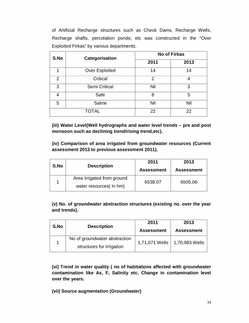
Exploited Firkas” by various departments.
S.No Categorisation No of Firkas
2011 2013
1 Over Exploited 14 14
2 Critical 2 4
3 Semi Critical Nil 3
4 Safe 8 5
5 Saline Nil Nil
TOTAL 22 22
(iii) Water Level(Well hydrographs and water level trends – pre and post monsoon such as declining trend/rising trend,etc). (iv) Comparison of area irrigated from groundwater resources (Current assessment 2013 to previous assessment 2011).
S.No Description 2011
Assessment
2013
Assessment
1 Area Irrigated from ground
water resources( In hm) 6538.07 6505.06
(v) No. of groundwater abstraction structures (existing no. over the year and trends).
S.No Description 2011
Assessment 2013
Assessment
1 No of groundwater abstraction
structures for Irrigation 1,71,071 Wells 1,70,983 Wells
(vi) Trend in water quality ( no of habitations affected with groundwater contamination like As, F, Salinity etc. Change in contamination level over the years. (vii) Source augmentation (Groundwater)

35
Area covered with infrastructure for recharging groundwater:
The proper artificial recharge structures has to be constructed based on local geological conditions in the areas of existing infrastructure for recharging groundwater according to their extraction needs.
GW recharge plan to combat adversaries: Groundwater recharge plans has to be strictly followed by with of implementing the groundwater laws to combat adversaries.
9. Reforms undertaken/being undertaken/proposed if any.
10. Road Map of activities/tasks proposed for better governance with timelines and agencies responsible for each task/activity.


