
1
CENTRAL SCHEME
OF
ETHEKWINI MUNICIPALITY

2
CONTENTS SECTION 1 ...................................................................................................................................................................... 5 1.1 TITLE ........................................................................................................................................................................ 5
1.2 RESPONSIBLE AUTHORITY .................................................................................................................................. 5
1.3 REFERENCE TO A MAP ......................................................................................................................................... 5
1.4 PURPOSE OF THE SCHEME.................................................................................................................................. 5
1.5 AREA OF THE SCHEME ......................................................................................................................................... 6
1.6 EFFECTIVE DATE OF THIS SCHEME ................................................................................................................... 6
1.7 AMENDMENT TO THE SCHEME ............................................................................................................................ 6
1.8 INSPECTION OF THE SCHEME ............................................................................................................................. 6
1.9 STATUS OF THE SCHEME ..................................................................................................................................... 6
1.10 RESERVATION OF LAND ..................................................................................................................................... 7
1.12 EXISTING USE RIGHTS ........................................................................................................................................ 8
1.13 EXEMPTIONS ........................................................................................................................................................ 9
1.13.1 GENERAL .......................................................................................................................................................... 9 1.13.2. ANCILLARY UNITS ............................................................................................................................................ 9 1.13.3. SHORT TERM ACCOMMODATION ESTABLISHMENT ................................................................................. 10 1.13.4. HOME BUSINESS ............................................................................................................................................ 11 1.13.5 TUCK SHOP/SPAZA SHOP .............................................................................................................................. 12 1.13.6 OFFICES IN THE VICINITY OF COMMERCIAL ZONES ............................................................................... 13 1.13.7 MEDICAL OFFICES ........................................................................................................................................... 13 1.13.8 HOME CARE FACILITY .................................................................................................................................... 14 1.13.9 TAVERNS .......................................................................................................................................................... 15 1.13.10 EARLY CHILD DEVELOPMENT CENTRES................................................................................................... 16 1.14 DECLARING, CLOSING OR DIVERTING OF STREETS ................................................................................... 17
1.15 APPLICATIONS ................................................................................................................................................... 18
1.16. ENTRY AND INSPECTION ................................................................................................................................. 18
1.17. SERVING OF NOTICES ...................................................................................................................................... 18
1.19. SIGNAGE, HOARDING AND ADVERTISEMENTS ........................................................................................... 18
1.20. DURBAN METROPOLITAN OPEN SPACE SYSTEM CONTROLLED AREA ................................................. 19
1.20.2 LIMITATIONS UPON DEVELOPMENT DUE TO LACK OF SERVICES, UNSUITABILITY OF LAND, ENVIRONMENTAL AND OTHER CAUSES. ................................................................................................... 19
1.21 COASTAL MANAGEMENT CONTROLLED AREA ............................................................................................ 19
1.22 CONSOLIDATION OF LAND............................................................................................................................... 21
1.23 SUBDIVISION OF LAND ..................................................................................................................................... 21
1.24 REZONING OF LAND .......................................................................................................................................... 21
1.25 SPECIAL CONSENT ............................................................................................................................................ 21
1.26 TITLE DEED CONDITIONS ................................................................................................................................. 21
1.27. CONTROLLED INTERFACE AREAS ................................................................................................................ 21
SECTION 2: DEFINITIONS 22 2.1 GENERAL DEFINITIONS .................................................................................................................................... 22 2.2 LAND USE DEFINITIONS ................................................................................................................................... 27 SECTION 3: SPACE ABOUT BUILDINGS 33 3.1 BUILDING LINES ................................................................................................................................................... 33
3.2 SIDE AND REAR SPACE ...................................................................................................................................... 34
SECTION 4: ERF CONTROL 36 MINIMUM FRONTAGE AND HATCHET ACCESS REQUIREMENTS ........................................................................ 38 SECTION 5: FLOOR AREA, COVERAGE AND HEIGHT 39 5.1. FLOOR AREA RATIO ........................................................................................................................................... 39
5.2 COVERAGE ........................................................................................................................................................... 39
5.3 HEIGHT .................................................................................................................................................................. 40
SECTION 6: RESERVATION OF LAND 42 SECTION 7: 46
3
ZONE: AIRPORT 46 ZONE: BRIDGE CITY 47 ZONE: BEACH 52 ZONE: CEMETERY 53 ZONE: CONSERVATION 54 ZONE: COMMUNITY FACILITY 57 ZONE: CRÈCHE 58 ZONE: CULTURAL & ENTERTAINMENT 59 ZONE: EDUCATION 1 60 ZONE: EDUCATION 2 61 ZONE: EDUCATION 3 62 ZONE: EXTRACTIVE INDUSTRY 63 ZONE: FUELLING AND SERVICE STATION 64 ZONE: GENERAL BUSINESS (CENTRAL) 65 ZONE: GENERAL BUSINESS 2 67 ZONE: GENERAL BUSINESS 3 68 ZONE: GENERAL COMMERCIAL 70 ZONE: GENERAL INDUSTRY 71 ZONE: GENERAL RESIDENTIAL 1 72 ZONE: GENERAL RESIDENTIAL 2 74 ZONE: GENERAL RESIDENTIAL 3 75 ZONE: GENERAL RESIDENTIAL 4 76 ZONE: GENERAL RESIDENTIAL 5 77 ZONE: HARBOUR 79 ZONE: HOTEL 80 ZONE: INDETERMINATE 81 ZONE: INSTITUTIONAL 1 82 ZONE: INSTITUTIONAL 2 83 ZONE: INSTITUTIONAL 3 85 ZONE: INSTITUTIONAL 4 86 ZONE: INTERMEDIATE RESIDENTIAL 87 ZONE: IPTN MIXED USE 1 88 ZONE: IPTN MIXED USE 2 89 ZONE: IPTN MIXED USE 3 91 ZONE: IPTN RESIDENTIAL 92 ZONE: IPTN TRANSPORT DEPOT 93 ZONE: TRANSPORT ORIENTED DEVELOPMENT 94 ZONE: LIGHT INDUSTRY 95 ZONE: LIMITED COMMERCIAL 96 ZONE: LOGISTICS 98 ZONE: MIXED USE 1 99 ZONE: MIXED USE 2 100 ZONE: MEDIUM DENSITY HOUSING 101 ZONE: NOXIOUS INDUSTRY 103 ZONE: OFFICE 104 ZONE: PRIVATE OPEN SPACE 105 ZONE: SPECIAL RESIDENTIAL 180 108 ZONE: SPECIAL RESIDENTIAL 400 109 ZONE: SPECIAL RESIDENTIAL 900 110 ZONE: SPECIAL RESIDENTIAL 1200 111 ZONE: SUBURBAN OFFICE 112 ZONE: TRANSPORT 113 ZONE: WORSHIP 114 SPECIAL ZONE 1: PARKING GARAGE - VICTORIA PARK 115 SPECIAL ZONE 2: GENERAL RESIDENTIAL AND PARKING ZONE 116 SPECIAL ZONE 3: CARAVAN AND ECO PARK 117 SPECIAL ZONE 4: PARKING ZONE 120 SPECIAL ZONE 5: GROUP HOUSING 121 SPECIAL ZONE 6: PHOENIX TOWN CENTRE 122 SPECIAL ZONE 7: NATAL NEWSPAPERS 130 SPECIAL ZONE 8: MARBLERAY SHOPPING 131 SPECIAL ZONE 9: ATHERTON 132 SPECIALZONE 10: GREYVILLE VILLAGE 133 SPECIAL ZONE 11: PIEDMONT PARK OFFICES 134 SPECIAL ZONE 12: CONVENTION CENTRE 135 SPECIAL ZONE 13: ST. IVES ROAD 136
4
SPECIAL ZONE 14: STONEBRIDGE 137 SPECIAL ZONE 15: UMGENI BUSINESS PARK 139 SPECIAL ZONE 16: RIVERHORSE VALLEY 139 SPECIAL ZONE 17: MOUNT MORIAH 144 SPECIAL ZONE 18: UMGENI RIVER BIRD AND ZOOLOGICAL PARK 146 SPECIAL ZONE 19: SMART EXCHANGE 147 SPECIAL ZONE 20: ANSTEY RD 148 SPECIAL ZONE 21: SHIRES QUARRY 150 SPECIAL ZONE 22: SUNCOAST 152 SPECIAL ZONE 23: BEREA ROAD 153 SPECIAL ZONE 24: POINT WATERFRONT 154 SPECIAL ZONE 25: GLADYS MAZIBUKO ROAD 159 SPECIAL ZONE 26: BROADWAY PRECINCT 161 SPECIAL ZONE 27:MONDI 164 SPECIAL ZONE 28: IRPTN MIXED USE RESIDENTIAL 165 SPECIAL ZONE 29 : THE BRICKWORKS 166 SPECIAL ZONE 30: GAINSBOROUGH DRIVE 168 SPECIAL ZONE 31: SPARKS/BRICKFIELD: HIGH STREET PRECINCT 2: MOSES KOTANE ROAD 169 SPECIAL ZONE 32: FILM STUDIOS, ANCILLARY ACTIVITIES AND RELATED BUSINESS 170 SPECIAL ZONE 33: UMLAZI STATION 171 SPECIAL ZONE 34: KWAMNYANDU 172 1. Development Aims ...................................................................................................................................... 172
2. Development Principles .............................................................................................................................. 172
3. Development Rights ........................................................................................................................................ 172 SPECIAL ZONE 34: KWAMNYANDU LAND USE TABLES 174 SPECIAL ZONE 34: KWAMNYANDU LAND USE TABLES 175 SPECIAL ZONE 34: KWAMNYANDU LAND USE TABLES 176 SECTION 8: PARKING AND LOADING STANDARDS 199 SECTION 9: DEVELOPMENT STANDARDS 212 9.1 BASE TELECOMMUNICATIONS TRANSCEIVER STATIONS (CELLULAR MASTS) .................................. 212 9.2 DESIGN OF A FUELLING AND SERVICE STATION ...................................................................................... 217 9.3 DESIGN AND LAYOUT FOR A MOBILE HOME PARK DEVELOPMENT ..................................................... 219 9.4 IMPORTANT BUILDINGS AND OBJECTS (see list at Annexure B) ............................................................ 220 9.5 DURBAN METROPOLITAN OPEN SPACE SYSTEM CONTROLLED AREA. .............................................. 220 9.6 COASTAL MANAGEMENT CONTROLLED AREA. ........................................................................................ 221 9.7 RENEWABLE ENERGY INSTALLATIONS ..................................................................................................... 221 SECTION 10: LIST OF AMENDMENTS 223 SECTION 11: APPENDICES 224 SECTION 12: ANNEXURES 229

5
SECTION 1
1.1 TITLE
1) This Scheme is established in terms of the eThekwini Municipality Land Use Management by-Law 2016, framed against the Spatial Planning Land Use Management Act, 2013, (Act No. 16 of 2013).
2) This scheme shall be known as the Central Scheme and applies to all erven within the jurisdiction of the Central Region of the Municipality over which a Scheme has been put in place as shown on the associated Scheme maps.
1.2 RESPONSIBLE AUTHORITY
The Municipality shall be the only authority responsible for enforcing and carrying into effect the provisions of
this Scheme.
1.3 REFERENCE TO A MAP
The Scheme Map shall comprise a series of maps reflecting all districts within the Central Region Area and the overlay mapping of the Durban Metropolitan Open Space System (D’MOSS).
1.4 PURPOSE OF THE SCHEME
1.4.1 The Central Scheme and Scheme Maps form part of the Land Use Management System that applies
to all Erven within the boundary of the Municipality (Central Region), over which a scheme has been
put into place.
1.4.2 The purpose of the Scheme is to: -
(i) Enable the comprehensive management of all Erven (both private and public sector) within the
Municipality, over which a scheme has been put into place;
(ii) Promote and implement the applicable planning and development legislation and principles as
adopted by the relevant national, provincial and municipal spheres of government from time to time;
(iii) Promote and implement the vision and strategies of the Integrated Development Plan in the
realisation of quality environments; and
(iv) Manage land-use rights, provide for facilitation over use rights, manage urban growth and
development, and manage conservation of the natural environment, in order to:
(a) achieve co-ordinated and harmonious development in a way that will efficiently promote public
safety, health, order, convenience and to protect the general welfare of the inhabitants of the
Municipality;
(b) promote integrated and sustainable development throughout the area of jurisdiction;
(c) promote sustainable environmental management, conserve and protect environmentally sensitive
areas; and
(d) promote all forms of development and growth through sound Planning Principles that would
6
support a mix of land-uses managed in an appropriate manner.
1.4.3. Any application submitted prior to the adoption of this Scheme shall be assessed and finalised under the provisions of such former Scheme regulations, except if the applicant has in writing informed the Municipality that he / she withdraws such application.
1.4.5. If any provision of this Scheme is deemed invalid by any court of law, such provision shall be severed
from this Scheme, but not affect the validity of the remaining provisions.
1.5 AREA OF THE SCHEME
The Central Scheme applies to all land within the jurisdiction of the Central Region of the Municipality as shown
on the associated Scheme Map ref CS/06/2019
1.6 EFFECTIVE DATE OF THIS SCHEME
The effective date for this scheme is 31 October 2019.
1.7 AMENDMENT TO THE SCHEME
In respect of any amendment of the scheme, the Municipality shall comply with Prevailing Planning legislation.
1.8 INSPECTION OF THE SCHEME
1.8.1 The Scheme (Regulations and Maps) are public documents and open for inspection by the general
public at any reasonable time.
1.8.2 A register of all applications and decisions on the Scheme Regulations and Maps shall be kept and
shall be available for inspection by any person or persons at any reasonable time.
1.9 STATUS OF THE SCHEME
1.9.1 A scheme is binding on the Municipality, all other persons and organs of state, except in the event of a conflict with the provisions of an integrated development plan that was adopted prior to the scheme or amendment to the scheme.
1.9.2 The provisions of the Integrated Development Plan will prevail over the provisions of a scheme in the event of a conflict with the provisions of an integrated plan that was adopted prior to the scheme or amendment to the scheme
1.9.3. The provisions of a scheme that were adopted prior to the adoption of an integrated development plan
prevail in the event of a conflict with the provisions of the integrated development plan. 1.9.4. A Municipality or any other organ of state may not approve a proposal to subdivide or consolidate land
that is in conflict with the provisions of a scheme. 1.9.5. An approval to subdivide or consolidate land that is in conflict with the provisions of a scheme is invalid. 1.9.6. Any part of a scheme that applied to land that has been incorporated into another Municipality in the
Province as a result of the redetermination of a Municipality boundary by the demarcation board in terms of the local government; Municipal Demarcation Act, 1998 (Act No. 27 of 1998), or any subsequent replacement legislation, must be treated as a scheme of the receiving Municipality.
1.9.7. A scheme replaces all town planning schemes within the area to which it applies. The legal status of
an existing building or structure that has been lawfully erected before the effective date of the adoption, replacement or amendment of a scheme in terms of current applicable Planning legislation is not affected by the adoption, replacement or amendment of the scheme.
1.9.8. Land that was being used lawfully before the effective date for the adoption, replacement or
amendment of a scheme contemplated in terms of current applicable legislation, for a purpose that does not conform to this scheme, may continue to be used for that purpose.

7
1.9.9. Any extension to buildings or structures on land contemplated in this sub-section must comply with the scheme.
1.9.10 An owner who believes that the Scheme contains an error in respect of their property may apply to
the Head: Development Planning, Environment and Management to correct the error. 1.9.11 An owner making an application contemplated in subsection (1.9.10) –
(i) must describe the nature of the error; (ii) bears the onus of proving the error and must provide written proof of the lawful land
development use rights; and (ii) must indicate the correct zoning.
1.9.12 Status of zoning map and exemption of the Municipality from liability for any error:
(i) The zoning map is the Municipalities’ record of the zoning of each erf; (ii) A zoning recorded in the zoning map is presumed to be the correct zoning unless proved
otherwise; (iii) A zoning ceases to exist on the day it lapses in terms of this Scheme, through amendment or
a previous zoning Scheme, even if the zoning map still records the use right as existing.
1.9.13 The Head: Development Planning, Environment and Management is exempt from liability for any damage which may be caused by –
(i) an error in the zoning map; or
(ii) an erroneous representation by the Head: Development Planning, Environment and
Management about a use right or the zoning of an erf.
1.10 RESERVATION OF LAND
1.10.1 The relevant areas of land shown on the Scheme Map as Reservations and listed in Section 6:
Reservation of Land may only be used for the purposes and under the conditions, set out therein.
1.10.2 Where reservations for purposes such as public open space, road, Provincial, National and Local
Government, essential services appear on an Erf, no person shall erect a building or execute any other
work on the reserved land save with the Special Consent of the Municipality after approval by the organ
of state concerned; provided that any existing land use or existing building may continue until such
time as the Municipality has acquired and transferred ownership of the land in terms of the provisions
of the Local Authorities Ordinance or any other similar law. In granting its Special Consent under this
clause the Municipality shall only permit uses that are of a temporary nature and it shall specify the
date on which consent shall expire.
1.11 USE OF LAND AND BUILDINGS
1.11.1 The types of buildings and land uses contemplated for this Scheme are defined in Section 2 of this
scheme.
1.11.2 The extent and location of the various zones shall be as set out on the adopted Scheme Maps. Within
each zone the defined buildings and land use activities contemplated are separated into three
categories:
i. Primary: Land may be used or buildings may be erected and used with a written authority of
the Municipality;

8
ii. Special Consent: Land may be used or buildings may be erected and used only with the
Special Consent of the Municipality;
iii. Precluded: Those buildings and land uses which are expressly prohibited.
1.11.3 In considering any application, the Municipality;
i) may impose whatever conditions it deems necessary
Provided that where the Municipality has imposed conditions in terms of (i) above, the applicant shall
have a right of Appeal to the relevant Appeals Authority.
1.11.4. In approving any application, the Municipality shall take into consideration the nature of the proposed use in relation to the character of the area and impose whatever conditions it considers necessary to protect the amenities of the neighbourhood, subject to the right of appeal as is contemplated in terms current applicable Planning legislation. Any proposed use or development shall conform to the uses listed in these clauses for each zone. In this regard attention is drawn to the offenses and penalties sections contemplated in terms of current applicable Planning legislation.
1.11.5 Any decision, order or authorization given by a Planning and Development Appeal Tribunal in terms
of the current applicable Planning legislation or any alternative Planning and Development Appeal Tribunal set up in terms of an amendment or subsequent replacement legislation, shall be deemed to be a valid authority granted by the Municipality, and as such, shall be construed as being in accordance with the duly adopted provisions of the scheme.
1.11.6. No person shall bring onto any property in a residential zone, or cause to allow present thereon any
heavy or extra heavy duty vehicles except for bona fide purposes of delivering or supplying goods or services to such premises. The keeping of not more than two (2) public motor vehicles or trade vehicles, not exceeding a gross tare mass of three (3) tons, may be allowed by obtaining a permit for overnight parking. The applicant will be required to submit a letter of motivation, the vehicle registration details and the street address where such vehicle will be parked overnight, for such above-mentioned permit. .
1.12 EXISTING USE RIGHTS
1.12.1 The building types shall be defined as set out in Section 2 of this Scheme. The extent and location of the various zones shall be as set out in the corresponding Central Scheme Map, Map Reference Number CS/06/2019.
1.12.2. An existing building or an existing use of land which is not in conformity with the provisions of this
Scheme relating to the erection and use of buildings and the use of land, may be maintained and may be used for their existing purposes, provided that such existing building or land use was approved in terms of the Scheme applicable to it prior to the adoption of this Scheme or if such existing building or use of land enjoyed an existing use right status at the date of the adoption of the Scheme applicable to it.
1.12.3 Any such non-conforming existing building or use of land may be increased on the Erf by an amount
not greater than 20 per cent of its total floor area or area as the case may be, at the said date of adoption, provided further, that the completed building or use is in conformity with the other provisions of the Scheme, relating to the zone in which such building or use is situated. Notwithstanding the provisions of this sub-clause, the above additional floor area or area allowance may be increased, provided that the prior written consent of the registered owner of each adjoining property, and such other properties as the Municipality may direct, has first been obtained. Where such written consent is not forthcoming, the applicant shall, in seeking the consent, be required to apply for Special Consent. Thereafter no further increases shall be permitted.
1.12.3. Any existing building may be demolished and replaced by a new building on the same Erf and the
existing use may continue in the new building provided, however, that the proposed new building shall contain no greater cubic content than the existing building and shall have no greater superficial area on the ground floor than the existing building and provided also that the new building is in conformity with the other provisions of the Scheme. Any such new building shall be commenced, at least to the extent of completing the foundations of the new buildings, within a period of 18 months after the date
9
upon which the demolition of the existing building is completed. Any failure to commence re-building within this period of 18 months shall be deemed to terminate the existing use right.
1.12.4. Any alteration or addition or change which materially alters the character of an existing building or use
of land shall automatically remove such building or use of land from the category of “existing building”
or “existing use”.
1.13 EXEMPTIONS
1.13.1 GENERAL
Nothing in the Scheme shall prohibit or restrict:
(i) The Winning of minerals, sand by underground or surface work without first obtaining Special Consent of the Municipality. (Sand-winning)
(i) The temporary use of any premises; provided that such use is restricted to not more than a total of 28 days in any one calendar year, and provided further that the written authority of the Municipality has been applied for and obtained. Such authority shall be granted by the Municipality, if it is satisfied that the amenities of the neighbourhood are not interfered with in any way, and may impose such conditions as it deems fit.
(ii) The use of a dwelling house as a boarding house for not more than four persons.
(iii) The installation of 5 limited pay-out machines which may be freely permitted on premises that are licensed to serve alcohol and where the playing of limited pay-out machines on the site will form a secondary activity to the main activity of the site. The installation of more than 5 machines (up to a maximum of 40 machines) will only be permitted where the zone permits a Place of Public Entertainment.
(iv) The use of a premises for the purposes of a Child Minder Service.
1.13.2. ANCILLARY UNITS
i) Intention of the Scheme
An Ancillary Unit shall have a gross permitted floor area not exceeding 80m²; provided that
verandahs and garages may be permitted over and above the permitted 80m² subject to
compliance with the provisions relating to coverage and floor area.
ii) The following shall apply when considering the establishment of an ancillary unit:
(a) There shall be no interleading doors between an ancillary unit and the main dwelling
house, provided that the Municipality may relax this provision, if there is a need for an
inter-leading door for health and safety reasons.
(b) In a multiple unit development, no Ancillary Unit/Units may be permitted. Where a site
is developed for a second dwelling house an ancillary unit may be permitted for each
dwelling house.
(c) The road or street access serving the Ancillary Unit shall be the same access which
serves the main dwelling, provided that the Municipality may, by reason of the same
access being impractical, or any other cogent reason, permit a road or street access
separate from that which serves the main dwelling house;
(d) An Ancillary Unit shall not be permitted to be separate in title from the main dwelling
house.

10
1.13.3. SHORT TERM ACCOMMODATION ESTABLISHMENT
i) Intention of the Scheme
The Intention of the Scheme is to allow the owner/occupier of a dwelling house to let a
maximum of ten bedrooms for accommodation purposes. The primary use of the erf shall
remain residential in nature and the Bed and Short Term Accommodation Establishment shall,
in the opinion of the Municipality, not negatively impact on the Neighbourhood. Short term
accommodation establishment includes a bed and breakfast establishment and online
accommodation bookings but excludes Student Accommodation and a Hotel.
ii) Nothing in this scheme shall prohibit or restrict the running of a short term accommodation
from a dwelling house provided that:
(a) the short term accommodation shall only be operated with the Special Consent of the
Municipality; provided that the Head: Development Planning Management and
Environment may waive compliance with the Special Consent procedure if the written
consent of the registered owner of each adjoining property and such other properties
as the Head: Development Planning Management and Environment may direct, is first
obtained and furnished to the Municipality;
(b) Uses incidental to the short term accommodation shall only be considered with the
Special Consent of the Municipality, and shall be limited to the exclusive use of the
patrons of the short term accommodation establishment.
(c) There shall at all times be either the owner or a manager or letting agent who shall be
responsible for the management of the establishment.
(d) The building shall, in the opinion of the Municipality, conform to the appearance and
definition of a dwelling house, so that upon the cessation of the use, the building shall
be capable of reverting to the use as a dwelling house;
(e) Parking for all guests shall be at one bay per room, and parking for the vehicles of the
manager or owner shall be provided on-site to the satisfaction of the Head: Development
Planning Management and Environment;
(f) No external advertising shall be permitted on the site other than a maximum of one
non-illuminated sign on each road frontage and each sign shall not exceed 0,20m2in
area. Any signage larger than 0,2 m2 will require an application to be made to the
signage department;
(g) After affording the applicant the opportunity of being heard, the Municipality may at
any time impose any further condition it deems reasonably necessary in order to
preserve the residential amenity of the area, or it may withdraw the Special Consent
if, in its opinion, the amenities of the neighborhood are being adversely affected by
the activities;
(g) If the use is discontinued for the period of 18 months, the dwelling house, insofar as it may
have been altered for that purpose, must be restored to its original state to the satisfaction
of the Head: Development Planning Management and Environment.”
iii) In considering such an application for Short Term Accommodation Establishment, the
Municipality shall take into consideration the following:-

11
(a) the scale of the operation in relation to the character of the area;
(b) the suitability of the premises concerned for the proposed use;
(c) the availability of on-site parking for motor vehicles; and
(d) any, other matters which would, in its opinion, interfere with the amenities of the
neighbourhood.
1.13.4. HOME BUSINESS
i) Intention of the Scheme
The Intention of the Scheme is to allow the owner/occupier of a Dwelling House to contribute
to the local economy of the Municipality. Land Uses that may be considered shall not in the
opinion of The Municipality negatively impact on the neighbourhood. Industrial uses such as
Panel Beating/Spray Painting/ Motor related uses as well as Engineering land uses such as
Burglar Guard Manufacture will not be allowed. For the purposes of a Home Business, a shop
is a prohibited land use. A home business is restricted to a single non impacting use.
ii) Nothing in this scheme shall prohibit or restrict the running of a Home Business from a dwelling
house provided that:
(a) The Home Business activity shall only be operated with the Special Consent of the
Municipality; provided that the Head: Development Planning Management and
Environment may waive compliance with the Special Consent procedure if the written
consent of the registered owner of each adjoining property and such other properties
as the Head: Development Planning Management and Environment may direct, is first
obtained and furnished to The Municipality;
(b) The area to be utilized for the Home Business shall not exceed 30% or a maximum
of 40m² (inclusive of storage areas, whichever is the lesser) of the existing area of
dwelling house existing on the Erf, and the predominant use shall remain residential;
(c) The dwelling house in which the Home Business is carried on must remain residential
in appearance and character, and must at all-time comply with the definition of
dwelling house;
(d) On–site parking and loading facilities shall be provided to the satisfaction of the Head:
Development Planning and Management;
(e) The hours of operation shall be to the satisfaction of the Head: Development Planning
Management and Environment, and shall be specified in the Special Consent granted;
(f) The Home Business must only be operated by a person who is the bona fide resident
in the dwelling house, and such person may not be assisted in the business by not
more than two people;
(g) No external advertising shall be permitted on the site except for one non-illuminated
sign on each road frontage, and each sign shall not exceed 0,20m2 in area. Any
signage larger than 0,2 m2 will require an application to be made to the signage
department;
(h) Storage of goods and equipment shall be within the area designated for that purpose
on the plan which is to accompany the application, detailing the area to be used for
the business as well as any portion of that area in which goods or equipment will be
stored;

12
(i) Only one light delivery vehicles may be used for the delivery to dispatch goods or
supplies;
(j) After affording the applicant the opportunity of being heard, the Municipality may at
any time impose any further condition it deems reasonably necessary in order to
preserve the residential amenity of the area, or it may withdraw the Consent if, in its
opinion, the amenities of the neighborhood are being adversely affected by the
activities of the business;
(k) If the use is discontinued for the period of 18 months, the dwelling house, insofar as it
may have been altered for that purpose, must be restored to its original state to the
satisfaction of the Head: Development Planning, Environment and Management.”
1.13.5 TUCK SHOP/SPAZA SHOP
i) Intention of the Scheme
The intention of the Scheme is to allow the owner/occupier of a dwelling house to sell goods
required for essential day to day needs of the neighborhood, in residential areas that are not
adequately serviced by such a facility. The sale of goods is to take place through a window,
doorway or hatchway only and shall not include a walk in shop. Such use shall not detract
from the residential character of the neighborhood, aesthetically or impact wise.
ii) Nothing in this scheme shall prohibit or restrict the running of a Tuck-shop/Spaza shop from a
dwelling house provided that:
(a) A Tuck-shop/Spaza shop activity shall only be operated with the Special Consent of
the Municipality; provided that the Head: Development Planning Management and
Environment may waive compliance with the Special Consent procedure if the written
consent of the registered owner of each adjoining property and such other properties
as the Head: Development Planning, Environment and Management may direct, is
first obtained and furnished to the Municipality;
(b) The area to be utilized for the Tuck-shop/Spaza Shop inclusive of storage areas shall
not exceed 20m² of the area of the dwelling house and the dwelling house must
remain residential in appearance and character, and must at all-time comply with the
definition of dwelling house,
(c) no external advertising shall be permitted on the Erf except for one non- illuminated
sign on each road frontage, and each sign shall not exceed 0,20m2 in area. Any
signage larger than 0,2 m2 will require an application to be made to the signage
department;
(d) Entertainment facilities shall not be permitted within a Tuck-shop;
(e) A Tuck-shop/Spaza shop shall not involve the sale of Alcohol or any other goods
which in the opinion of the Head: Development Planning and Environmental
Management are unnecessary for the day to day needs;
(f) A Tuck-shop/ Spaza shop must be operated in accordance with all relevant By-laws
and other legislation of the Municipality, particularly the Fire Regulations.
(g) The hours of operation shall be to the satisfaction of the Head: Development Planning,
Environment and Management;
(h) The storage of goods and equipment shall be within the area designated for that
purpose on the plan which is to accompany the application, detailing the area to be
used for the Tuck-Shop/ Spaza Shop as well as any portion of that area in which goods
or equipment will be stored;

13
(i) Only one light delivery vehicles may be used for the delivery to dispatch goods or
supplies;
(j) After affording the applicant the opportunity of being heard, the Municipality may at
any time impose any further condition it deems reasonable necessary in order to
preserve the residential amenity of the area, or it may withdraw the Special Consent
if, in its opinion, the amenities of the neighborhood are being adversely affected by
the activities of the business;
(k) The owner/occupier operating the Tuck-shop/Spaza shop may be assisted by not
more than one other person;
(l) In assessing any application, consideration shall be given to ensure that the location
of the Tuck-shop/Spaza shop does not compromise the principle of sound planning practice.
(m) If the use is discontinued for the period of 18 months, the dwelling house, insofar as it
may have been altered for that purpose, must be restored to its original state to the
satisfaction of the Head: Development Planning Management and Environment.”
1.13.6 OFFICES IN THE VICINITY OF COMMERCIAL ZONES
The Municipality may by Special Consent on any site situated contiguous to a site zoned commercial or where the major portion of the site is opposite such a site and separated there from by only a street and where the Municipality is satisfied that the development would enhance the amenity of the neighbourhood, authorise the erection of offices or the conversion to offices of the whole or any portion of a dwelling house, ancillary unit in any Special Residential, Multiple Unit Development or General Residential l, 2, 3 or 4 zone provided that the Municipality shall be satisfied that such office use will:-
(i) not prejudice the development of the commercial zone to which the site is contiguous or opposite; (ii) cater specifically for the needs of the neighbourhood; (iii) not unduly generate pedestrian traffic across any street to or from the commercial zone;
provided, further, that the Municipality may relax the requirements of provisos (i) to (iii) above where it is satisfied that the proposed development will:-
(a) Raise the environmental quality of a blighted area and thereby lead to the possible regeneration
of such area;
(b) Conserve a building which in the opinion of the Municipality is worthy of conservation. (c) The granting of approval in terms of this sub-section shall be subject to the following conditions:-
(i) the building shall be designed so as to harmonise with and in its external appearance, conform
to residential development existing or as contemplated in the zone in which it is situated; (ii) the property shall be laid out and maintained to the satisfaction of the Municipality; (iii) provision shall be made for the parking of vehicles in terms of Section 8 to the satisfaction of the
Municipality; (iv) goods shall not be displayed in the public view either in a window or otherwise.
1.13.7 MEDICAL OFFICES
(i) Intention of the scheme
The intention of the Scheme is to allow the owner/occupier of a dwelling house by special
consent authorise the erection of medical offices or the conversion of the whole or any portion
of a dwelling house for conducting the professions or occupations of a medical practitioner,
dentist, veterinarian, traditional healer and such other professions or occupations of a like or
allied nature. Such use shall not detract from the residential character of the neighborhood,
aesthetically or impact wise.
14
(ii) Nothing in this scheme shall prohibit or restrict the running of Medical Offices from a dwelling house provided that:
a) No medical offices or veterinary clinic may be permitted in a Special Residential zoned site
that is used for Multiple Unit Development purposes.
b) The building shall be designed so as to harmonise with and in its external appearance, conform to the residential development existing.
c) The following provision shall be made for parking: 1 parking space for every 20m2 of gross
office floor area. In addition provision shall be made for loading and off-loading, access and
egress to the satisfaction of the Head: Development Planning and Management. Provided
further that the surface material used to cover the parking area shall be to the satisfaction of
the Head: Development Planning, Environment and Management.
d) A minimum of 25 % of the site area, including the parking area, shall be landscaped and maintained to the satisfaction of the Head: Development Planning and Management.
e) Not more than six persons including practitioners and staff shall practice or be employed in
that portion of the premises to which the Municipality’s special consent relates.
f) No external advertising shall be permitted on the site other than a maximum of one non-illuminated sign on each road frontage and each sign shall not exceed 0,20m² in area. Any signage larger than 0,20m² will require an application to the signage department.
g) A veterinary clinic may include; the boarding of animals for short term care resulting from medical treatment only, a grooming parlour and a retail outlet restricted to the sale of veterinary and animal maintenance products considered ancillary to the veterinary practice.
h) Medical offices are for the provision of health services and may include laboratories associated therewith, but which do not provide overnight care or serve as a base for an ambulance service. Medical offices are operated by doctors, dentists, chiropractors, homeopaths, traditional healers, or such similar practitioners.
1.13.8 HOME CARE FACILITY
i) Intention of the Scheme:
The Intention of the Scheme is to allow the owner or occupier of the dwelling house in any residential zone to let a maximum of ten bedrooms for the purposes of accommodation for the aged, and may include a dedicated registered health care professional. The primary use of the site shall remain residential in nature and the Aged Home Care Facility shall, in the opinion of the Municipality, not negatively impact on the neighbourhood.
ii) Nothing in the scheme shall prohibit or restrict the running of an Aged Home Care Facility from
a dwelling house provided that:
(a) the Aged Home Care Facility shall only be operated with the Special Consent of the Municipality; provided that the Head: Development Planning Management and Environment may waive compliance with the formal Special Consent procedure if the written consent of the registered owner of each adjoining property and such other properties as the Head: Development Planning Management and Environment may direct, is first obtained and furnished to the Municipality;
(b) full compliance with the current Municipal Health Bylaws;
(c) An Aged Home Care Facility shall not consist of more than ten bedrooms for the use
by patrons of the Establishment;
(c) There shall at all times be either the owner or a manager who shall be responsible for the management of the establishment.
15
(d) The building shall, in the opinion of Municipality, conform to the appearance and definition of a dwelling house, so that upon the cessation of the use, the building shall be capable of reverting to the use as a dwelling house without the need for alteration;
(e) Parking for all patrons shall be one bay per room, and parking for the vehicles of the
owner/manager shall be provided on-site to the satisfaction of the Head: Development Planning Management and Environment;
(f) No external advertising shall be permitted on the site other than a maximum of one
non-illuminated sign on each road frontage and each sign shall not exceed 0,20m2 in area. Any signage larger than 0,2 m2 will require an application to be made to the signage department;
(g) After affording the applicant the opportunity of being heard, the Municipality may at
any time impose any further condition it deems reasonably necessary in order to preserve the residential amenity of the area, or it may withdraw the Special Consent if, in its opinion, the amenities of the neighborhood are being adversely affected by the activities;
(h) If the use is discontinued for the period of 18 months, the dwelling house, insofar as it
may have been altered for that purpose, must be restored to its original state to the satisfaction of the Head: Development Planning Management and Environment.”
iii) In considering such an application for a Aged Home Care Facility, the Municipality shall take
into consideration the following:-
(a) The scale of the operation in relation to the character of the area; (b) The suitability of the premises concerned for the proposed use; (c) The availability of on-site parking for motor vehicles; and
(d) any other matters which would, in its opinion, interfere with the amenities of the neighbourhood.
iv) The granting of such an application shall be subject to such terms and conditions as the
Municipality may deem proper, including the provision of adequate off-street parking for motor vehicles, the number of persons that may be accommodated on the premises and any other condition it considers necessary or proper in order to ensure that the amenities of the area are not interfered with, provided that if it is subsequently found that there is in fact an interference with the amenities of the neighborhood, the Municipality may impose further conditions after affording the owner an opportunity of being heard or call on the owner to cease the usage.
1.13.9 TAVERNS
i) Intention of the Scheme
The Intention of the Scheme is to allow the owner/occupier of a Dwelling House to operate a Tavern, and contribute to the Local Economy of the Municipality, while adhering to the objectives of Chapter 1 (Section 2) the National Liquor Act, 2003, National Norms and Standards of the National Liquor act, 2003, and Chapter 1 (Section 2) of the Kwazulu-Natal Liquor Licensing Act, 2010 (the Act), and/or any other subsequent applicable legislation. Land Uses that may be considered shall not in the opinion of the Municipality negatively impact on the neighbourhood. A Tavern is restricted to a single non-impacting use.
ii) Nothing in this scheme shall prohibit or restrict the running of a Tavern (hereinafter referred to as
“operation”) from a Dwelling House premises provided that:
(a) The operation is in full compliance with all of the conditions and recommendations contained within, a Liquor license, issued by the KwaZulu-Natal Liquor Authority, in terms the Kwazulu-Natal Liquor Licensing Act, 2010, and / or any other subsequent applicable legislation.
(b) The operation shall only be operated with the Special Consent of the Municipality; provided that
the Head: Development Planning Management and Environment may waive compliance with the Special Consent procedure if the written consent of the affected property owners, and such other

16
properties as the Head: Development Planning Management and Environment may direct, is first obtained and furnished to the Municipality
(c) The proposed operation shall not be located within a 500 metre radius of any religious or learning
institutions, as determined by the KwaZulu-Natal Liquor Authority. A site/area plan, indicating such institutions, must be submitted with the application.
(d) The proposed operation shall not be located within a 500 metre radius of other licensed operations
within a residential area, as determined by the KwaZulu-Natal Liquor Authority. A site/area plan, indicating other operations, shall be submitted with the application.
(e) With regards to items (c) and (d) above, a 250m radius may also be taken into consideration
depending on density of population and residences.
(f) Applications shall include a detailed security plan of the measures to be taken by the applicant in terms of providing security measures for both inside the proposed premises, as well as within the circumference of 5 metres outside the proposed premises, .
(g) Unless otherwise stipulated by applicable legislation, the hours of operation shall be limited to the
hours between 10:00 and 21:00 Monday to Saturday, and between 10:00 and 17:00 on a Sunday. (h) The operation, and all activities connected therewith, must be confined to the indicated operational
(Tavern) area and to remain separate of any main dwelling on site, inclusive of storage areas.
(i) Adequate facilities for refuse and waste disposal shall be provided, to the satisfaction of the eThekwini: Environmental Health Department
(j) The operation is not to be used for the bottling of liquor, or for the sale of liquor for consumption
off premises.
(k) The operation may include the consumption of non-alcoholic beverages and the preparation and consumption of food, but shall not include the sale of the aforesaid items for consumption off premises.
(l) On–site parking and loading facilities shall be provided, all to the satisfaction of the Head:
Development Planning and Management and Head: eThekwini Traffic Authority. (m) No external advertising shall be permitted on the site other than a maximum of one non-illuminated
sign on each road frontage and each sign shall not exceed 0.2 m² in area. Any signage larger than 0.2 m² will require an application to be made to the municipal signage department;
(n) Storage of goods and equipment shall be within the area designated for that purpose on the plan
which is to accompany the application for Consent, detailing the area to be used for the business as well as any portion of that area in which goods or equipment will be stored;
(o) After affording the applicant the opportunity of being heard, the Municipality may at any time
impose any further condition it deems reasonably necessary in order to preserve the residential amenity of the area, or it may withdraw the consent if, in its opinion, the amenities of the neighborhood are being adversely affected by the activities of the operation;
(p) If the use is discontinued for the period of 18 months, the original premises, insofar as it may have
been altered for that purpose, must be restored to its original state to the satisfaction of the Head: Development Planning Management and Environment.
(q) This scheme provision does not exempt the applicant from compliance with any other applicable legislation.
1.13.10 EARLY CHILD DEVELOPMENT CENTRES
i) Intention of the Scheme The Intention of the Scheme is to allow the owner/occupier of any Premises to operate Early Childhood Development Centres as supported by the Children’s Act 38 of 2005 (and supported by the National Integrated Early Childhood Development Policy of 2015), and any subsequent amendments to such legislation. Land Uses that may be considered, shall not in the opinion of the Municipality negatively

17
impact on the neighbourhood. For the purposes of an Early Child Development Centre, a shop is a prohibited land use, but a tuck-shop may be permitted. An Early Child Development Centre is restricted to a single non impacting use. ii) Nothing in this scheme shall prohibit or restrict the running of an Early Child Development Centre from any premises provided that:
a) Written proof of initial consultation and qualification as an Early Childhood Development service provider, or similar, from Department of Social Development is provided.
b) Full compliance with the municipalities Child Care Facilities By-Law of 2016 (or subsequent legislation) is adhered to.
c) A Health Compliance Certificate issued in terms of the municipalities Child Care Facilities By-
Law of 2016 (or subsequent Legislation) is provided.
d) The Early Child Development Centre activity shall only be operated with the Consent of the Municipality; provided that the Head: Development Planning Management and Environment may waive compliance with the Special Consent procedure if the written consent of the affected property owners, and such other properties as the Head: Development Planning Management and Environment may direct, is first obtained and furnished to the Municipality;
e) On–site parking and loading facilities shall be provided to the satisfaction of the Head:
Development Planning and Management;
f) No external advertising shall be permitted on the site other than a maximum of one non-illuminated sign on each road frontage and each sign shall not exceed 0.2 m² in area. Any signage larger than 0.2 m² will require an application to be made to the signage department;
g) Storage of goods and equipment shall be within the area designated for that purpose on the
plan which is to accompany the application for Consent, detailing the area to be used for the Early Child Development Centre as well as any portion of that area in which goods or equipment will be stored;
h) After affording the applicant the opportunity of being heard, the Municipality may at any time
impose any further condition it deems reasonably necessary in order to preserve the amenity of the area, or it may withdraw the consent if, in its opinion, the amenities of the neighborhood are being adversely affected by the activities of the Early Child Development Centre;
i) The hours of operation shall be to the satisfaction of the Head: Development Planning
Management and Environment, and shall be specified in the Special Consent granted;
If the use is discontinued for the period of 18 months, the dwelling house, insofar as it may have been altered for that purpose, must be restored to its original state to the satisfaction of the Head: Development Planning Management and Environment.”
1.14 DECLARING, CLOSING OR DIVERTING OF STREETS
1.14.1 All streets and roads shown on the Scheme Map and the widening of existing streets and roads shown
in red on the Scheme Map are to be new streets and roads, and shall become effective at dates to be
determined. All streets and roads shown in red hatch on the Scheme Map are to be closed at dates to
be determined.
1.14.2 Where the Municipality adopts an amendment to the Scheme which has the effect of altering the use
of an Erf in such a way that the development of the Erf concerned in terms of the amendment to the
scheme will create the need for the widening of any road or the creation of a new road, the Municipality
may require as a condition of the development of the Erf that the owner thereof provide free of any cost
and compensation a servitude over the Erf concerned for such road widening or new road in favour of
the Municipality.
1.14.3 The width extent and dimensions of the road widening or new road referred to shall be determined by
the Municipality and be subject to a detailed survey thereof.

18
1.14.4 Unless otherwise specified, wherever a road widening or proposed road is shown on the Scheme Map, the underlying zoning shall be the same as the Erf on which such road widening or proposed is located.
1.15 APPLICATIONS
1.15.1 At any time after the effective date no person shall:
(i) Erect a new building, or alter or add to an existing building or carry out any other proposed work,
or
(ii) develop or use any land, or use any building or structure for any purpose different from the
purpose for which it was being developed or used on such date, or
(iii) use any building or structure erected after such date for a purpose or in a manner different from
the purpose for which it was erected:-
until the applicant has first applied in writing to the Municipality for authority to do so and the
Municipality has granted its written authority thereto either with or without conditions;
a) Provided that any approval granted by the Municipality shall remain valid for a period in
accordance with the prevailing legislation; and
b) where any building or work referred to in any such Approval has not been substantially
commenced within the said period or where an appeal has been lodged, within a period
as specified in accordance with the prevailing legislation from the date of notification of
the outcome of such appeal, or where there has been an interruption in the development
of the building or land for a continuous period in accordance with the prevailing legislation,
the said Approval shall automatically be considered to have lapsed and building
operations or use of land shall not be commenced or recommenced unless a new
Approval has first been applied for and obtained.
1.16. ENTRY AND INSPECTION
1.16.1. The Municipality shall be entitled, through its duly authorised officers, to enter into and upon any
premises within its area of jurisdiction at any reasonable time for the purpose of carrying out any
inspection necessary for the proper administration and enforcement of the provisions of the scheme.
1.16.2. No person shall in any way hinder, obstruct or interfere with any duly authorised officer of the
Municipality in the execution of their duties and functions in terms of this Scheme, nor shall any person
cause or allow any hindrance, obstruction or interference with such officer.
1.17. SERVING OF NOTICES
1.17.1 Any notice required or authorized to be served in terms of the Scheme, shall be served in terms of the
current applicable Planning legislation
1.19. SIGNAGE, HOARDING AND ADVERTISEMENTS
1.19.1 No signage or advertisements shall be displayed or any hoarding permitted without the approval of the
Municipality. Any person proposing to erect any sign, advertisement or hoarding shall submit drawings
of such signage or advertisement or hoarding for approval. No hoarding or advertisement shall be
permitted which is likely to cause injury or affect the amenity of the neighbourhood. Nameplates not
exceeding 0.2m² in extent are not considered to fall under this heading. This Section does not apply to
casual advertisements for entertainment, property for sale, auctions to be held on the premises or
meetings, provided they are not, in the opinion of the Municipality, unduly ostentatious, and do not
interfere with pedestrian or vehicular access or visibility.
1.19.2 A plan indicating maximum, minimum and partial control areas for the entire jurisdiction of the
Municipality is administered by the Signage Department. All outdoor advertising shall be in accordance
with the South African Manual for Outdoor Advertising Control (SAMOAC) the Municipality’s signage
policy and associated plans.

19
1.20. DURBAN METROPOLITAN OPEN SPACE SYSTEM CONTROLLED AREA
1.20.1 The Durban Metropolitan Open Space System (D’MOSS) is a layer of the Scheme and enforceable by the Municipality in consultation with the Deputy Head: Environmental Planning and Climate Protection. The implementation of this layer shall be in terms of Sub-Section 9.5 of this Scheme.
1.20.2 LIMITATIONS UPON DEVELOPMENT DUE TO LACK OF SERVICES, UNSUITABILITY OF LAND, ENVIRONMENTAL AND OTHER CAUSES.
(a) No person shall within a Geotechnically advisory area (as defined in Section 2) develop any land,
or excavate or level any site, or remove any natural vegetation from, or erect any structure of any nature whatsoever or carry out any work upon such site without having obtained the prior approval of the Municipality in terms of this sub-section.
(b) No such approval shall be given unless the Municipality, after due examination, and subject to such conditions as he/she may specify, is satisfied that any such development, erection or other work referred to in paragraph (a) hereof can be carried out without danger to the site, or any adjoining site or any building thereon.
(c) For the purpose of any examination referred to in paragraph (b), the applicant shall, where required by the Municipality, submit such plans or other information as the Municipality may require. Without affecting the generality of the aforegoing, such plans may be required by the Municipality:-
(i) to be certified by a Land Surveyor or Consulting Engineer as being correct;
(ii) to show sections through the site over the area to be developed down the line of greatest slope, accurate to 50 millimetres and to scale of 1 : 100;
(iii) to show sections at intervals not exceeding 10 metres across the site or at such closer intervals as the Municipality may require.
(d) The conditions referred to in paragraph (b) hereof may be such as to:-
(i) restrict the form or nature of the building or structure;
(ii) limit the size and/or shape of the building or structure;
(iii) prescribe the form of foundations for the building or structure;
(iv) prescribe or restrict the materials of which the building or structure is to be constructed; (v) determine the siting of any building or structure and of any soakpits or other drainage works;
(vi) prohibit or control any excavation on the site, the construction of any roadways, paths and other
garden features;
(vii) prohibit or control the removal of any natural vegetation;
(viii) control any other aspects which the Municipality considers to be desirable.
(e) Notwithstanding anything contained in this sub-section the Municipality shall not be liable for any loss or damage which may occur to any building, structure or any property whether within a Geotechnically advisory area or otherwise arising out of any action by the Municipality in terms of this sub-section.
1.21 COASTAL MANAGEMENT CONTROLLED AREA
1.21.1 The Coastal Management controlled area is a layer of the Scheme established to manage the coastal zone in compliance with the National Environmental Management: Integrated Coastal Management (ICM) Act (Act 34 of 2008) and the eThekwini Municipality’s Coastal Management Bylaw 2018. This layer provides for the co-ordinated and integrated management of the coastal zone.
Furthermore, it aims to preserve, protect, extend and enhance the status of coastal public property as

20
being held in trust by the State on behalf of all South Africans, including future generations in terms of the duty of care enshrined in the Constitution. It also serves to ensure equitable access to the opportunities and benefits of coastal public property.
1.21.2 This Coastal Management Controlled Area serves as the Municipality’s Coastal Planning Scheme in terms of the ICM Act Section 57. This layer is enforceable by the Municipality in consultation with the Project Executive: Coastal Policy.
The implementation of this layer shall be in terms of Sub-Section 9.6 of this Scheme.
1.21.3 LIMITATIONS UPON DEVELOPMENT DUE TO COASTAL HAZARDS.
(a) No person shall within a Coastal Management Controlled Area develop any land, or excavate
or level any site, or remove any natural vegetation from, or erect any structure of any nature whatsoever or carry out any work upon such site without having obtained the prior approval of the Municipality in terms of this sub-section.
(b) No such approval shall be given unless the Municipality, after due examination, and subject to
such conditions as he/she may specify, is satisfied that any such development, erection or other work referred to in paragraph (a) above can be carried out in compliance with the ICM Act, Bylaws, Policies and any other laws.
(c) For the purpose of any examination referred to in paragraph (b), the applicant shall, where
required by the Municipality, to submit such plans or other information as the Municipality may require. Without affecting the generality of the aforegoing, such plans may be required by the Municipality:-
(i) to be certified by a Consulting Coastal Engineer as being correct; (ii) to show sections through the site over the area to be developed to the property
boundaries (iii) to show in the case of properties abutting the shoreline/sea, sections through the site and
continuing seaward down to the Low Water Mark (LWM); (iv) to show the position of the Coastal Management Line, as Gazetted by the MEC, on such
plans; (v) to comply with the eThekwini Municipality’s Policy on the minimisation of shadows on
beaches by providing a shadow study showing the impact of any building shadows that would be generated by the proposed building on public beach amenities;
(d) The conditions referred to in paragraph (b) hereof may be such as to:-
(i) restrict the form or nature of the building or structure; (ii) limit the size, position, height and/or shape of the building or structure; (iii) prescribe the form of foundations for the building or structure and/or sea protection
measures; (iv) prescribe or restrict the materials of which the building or structure is to be constructed; (v) determine the siting of any building or structure and of any soakpits, drainage works and
other services; (vi) prohibit or control any excavation on the site, the construction of any roadways, access
paths to the beach and other garden features; (vii) prohibit or control the removal of any natural vegetation; (viii) control any other aspects which the Municipality considers to be desirable.
(e) Notwithstanding anything contained in this sub-section the Municipality shall not be liable for
any loss or damage which may occur to any building, structure or any property whether within a Coastal Management Controlled Area or otherwise arising out of any action by the Municipality in terms of this sub-section and the ICM Act Section 100.

21
1.22 CONSOLIDATION OF LAND
Consolidation of land is where two or more Erven are combined together to form one new Erf, with boundaries
to be approved by the Surveyor-General and the new Erf is to be registered with the Registrar of Deeds. Any
person or organization could initiate a process to consolidate land in terms of the Prevailing legislation.
1.23 SUBDIVISION OF LAND
The sub-division of land is when an Erf is divided into more than one Erven. It requires new cadastral
boundaries which must be approved by the Surveyor-General, as well as the registration of newly created
Erven with the Registrar of Deeds. Any person or organization could initiate a process to subdivide land in
terms of the Prevailing legislation
1.24 REZONING OF LAND
Means a process whereby the current zoning as indicated on the Scheme Map and the corresponding controls relating thereto in the Scheme are amended in terms of the applicable legislation. In cases of a Rezoning, where the Minimum Subdivision indicated in Section 4: Erf Control and or Section 7: Development Facilitation Table is greater than the actual site size, further motivation, addressing any issues related to this aspect, may be requested at the discretion of the Head: Development Planning and Management.
1.25 SPECIAL CONSENT
1.25.1 The Special Consent of the Municipality is required when:
(i) the use that is proposed falls within the Special Consent column of the development facilitation
table of this scheme,
(ii) the use proposed is a Special Building,
(iii) the relaxation of space about buildings may be required,
(iv) a use that is proposed is a precluded use in terms of the development facilitation table or any
proposal that is in conflict with any provisions of the Scheme. It should be noted that the
Municipality is obliged to refuse such application.
(v) Whenever the Municipality grants its special consent for the use of land, the erection or use of a
building for a particular purpose or purposes, such land or building shall not be used for any other
purpose or be extended without the further special consent of the Municipality.
1.25.2 In considering any Special Consent application referred to in 1.25.1(i) above, the Municipality shall
take into consideration the impact of the proposed use on the surrounding area and may impose any
conditions it deems necessary to protect the amenities of the area.
1.26 TITLE DEED CONDITIONS
Any title deed conditions imposed upon any Erf shall prevail over the Scheme, provided that that an
application may be made for the removal of any title deed restrictions.
1.27. CONTROLLED INTERFACE AREAS
Preamble.
Controlled Interface Areas shall be identified on the map by a white circle in which is written the letter R in black, superimposed over a zone. The purpose of this sub-section is to:-
(a) identify portions of residential areas which are under pressure of encroachment by non-residential uses and have suffered a loss of residential amenity by virtue of their proximity to industrial and/or commercial uses or zones and/or major transportation routes;
22
(b) control the introduction of non-residential uses into the portions of the residential areas described in (a) so as to minimise the interference such uses may have on the amenities of those portions and the adjoining residential areas as they are when authority for those uses is sought or as contemplated by the Scheme;
(c) protect and promote the amenities of adjoining residential areas by confining the introduction of
non-residential uses to the portions of the residential areas described in (a); (d) enable land which is no longer suitable for residential use to be used more efficiently. This purpose can be achieved by demarcating areas (hereafter referred to as "Controlled Interface Areas") wherein non-residential uses may be authorised by Special Consent.
SECTION 2: DEFINITIONS
1.
2.
2.1 GENERAL DEFINITIONS
Access Strip: means a coterminous portion of Erf between its street boundary and that portion of Erf which is capable of containing in its boundaries a building or buildings and defining a line parallel to the side boundary, street boundary, right of way or road reservation, and which area on the Erf within which buildings may not be erected without the Special Consent of the Municipality. Activity Corridor: means an area of generally higher intensity urban use or land suitable for intensification, parallel to and on both sides of an activity spine, and includes any associated higher order transportation routes such as railway lines and through roads. Activity Spine: means a public street, incorporating an existing or planned public transport route, and adjacent land used or intended for mixed use development. Home Care Facility: means a dwelling house or ancillary unit that has been converted for the purpose of residential accommodation for the aged with a permanent manager on site and access to a dedicated registered health care professional. Registration with the Department of Social Welfare and other relevant departments is mandatory. Amenity: means a natural or created feature or aspect that enhances a particular property, place or area from the perspective of its aesthetic or social quality, or visual appeal, which makes it more attractive or satisfying to the human being. Ancillary Unit: means a self-contained inter leading group of rooms including not more than one kitchen designed for occupation by a single household or family with a total floor area not exceeding 80m². Antennae: means any form of transmitter intended for use to transmit or receive electronic communication signals, but shall exclude television receiving equipment with a diameter of 1.5 metres or less. Appeal Tribunal: Means a Planning Appeals Tribunal as established in terms current applicable Planning legislation. Approval: means the written approval of the Municipality. Balcony: means a floor projecting outside a building at a level higher than that of the ground floor, enclosed only by low walls or railings, or by main containing walls of rooms abutting such projecting floor, and includes

23
a roof, if any, over such floor and pillars supporting such roof. Basement: means the lowest part of any building which part is constructed with more than 50% of its volume below ground level. Ground level shall mean natural ground level, without any additional earthworks, as it existed prior to the conception of the building or development in question Short Term Accommodation Establishment: means a Dwelling House wherein a maximum of ten bedrooms may be used for the purpose of temporary accommodation of guests without impairing the amenity of the adjoining properties. Short Term Accommodation includes a Bed and Breakfast Establishment including online accommodation bookings but excludes Student Accommodation and a Hotel. Boat Launching Facility: means a place where boats or other water sport vessels are launched into water. Botanical Garden: means a park intended for the display of rare indigenous or exotic plants or trees. Boundary: means a line which defines the extent of an Erf and is indicated on a diagram registered in the Surveyor General’s office. Building: means Any structure of a movable or an immovable nature for whatever purpose used, including any tank (excluding underground tanks), swimming pool, or radio mast, telecommunications mast, and any wall, or close boarded fence more than 3 metres in height at any point, but excluding any open fence, post, steps, pier, fountain, fish pond, pergola, or other garden ornamentation. Building Line: a line parallel to a fixed distance from any street, public right of way, or road reserve. Bylaw: means the bylaws or regulations of the Municipality for the time being, inforce in the area of the Scheme. Canteen: means a building or part thereof, used for the preparation and serving of food and allied products, to all staff and students, which is ancillary to a business, educational establishment or other organization. Casino: within the meaning of Item 5 of Schedule 4A to the Constitution including, without derogating from the generality of the afore going, any premises in respect of which a Casino license is required in terms of the KwaZulu- Natal Gambling Act and includes a building in which gambling is permitted and may include ancillary facilities. Cellular Network Provider: means those companies who provide cellular network coverage. Child minder Service: means any undertaking involving the custody and care of a maximum of six (6) children apart from their parents during the whole or part of the day on all or any days of the week. Common Property: means that portion of the common land which is not covered by vehicular road reserves and parking areas, but may include walkways, whether grassed or hardened, and structures or buildings intended for recreational use of the occupants of the Erf to the satisfaction of the Municipality. Conference Facility: a building or portion of a building ancillary to the primary use of the site, used for conferences, seminars and meetings and may include offices for the administration of such centre. Conservation Reserve: means an area of land within which the conservation of the scenic beauty, indigenous fauna and flora, water courses, and other topographical features, places of historic or scientific interest and the like are of primary importance. Geotechnically Advisory Area: means any area demarcated upon the map by the overprinting of a red honeycomb pattern, where, by reasons of the topography, the unsuitability or instability of the soil or other like reasons, development or building may be prohibited, restricted, or permitted upon such conditions as may be specified having regard to the nature of the said area. Convenience Shop: means part of a building used in conjunction with a Fuelling and service Station used
24
primarily for the sale of convenience goods and which is subservient to that of a Fuelling and Service Station. Motor spares and accessories as well as promotional goods supplied by the oil companies may be sold, which shall include the convenience shop, storage areas associated therewith, refrigeration areas and food preparation areas. Coverage: means the proportion of an Erf covered by buildings with an impermeable roof, as seen vertically from the air measured from outer face of exterior walls, expressed as a percentage. Thus 25 % Coverage means that only one quarter of the Erf may be covered. Density: means the number of permitted dwelling units on an Erf. Density is expressed in terms of dwelling Units per hectare or unless otherwise stated. D’MOSS Controlled Area means any area demarcated upon the map by the overprinting of a green hatch pattern (or by a green layer on the GIS), where, by reasons of natural biodiversity, the existence of flora and fauna, topography, or the environmental goods and services provided or other like reasons, development or building may be prohibited, restricted or permitted upon such conditions as may be specified having regard to the nature of the said area. Domestic Staff Accommodation: means accommodation designed primarily for the housing of domestic staff, which may include not more than one kitchen, with a total floor area not exceeding 40 square meters in extent. Dwelling Unit: means a self-contained interleading group of rooms including not more than one kitchen designed for occupation by a single household or family and used and may include out buildings but excludes an ancillary unit/s. Dwelling Unit Curtilage: means a single defined area of land forming part of a Multiple Unit Development on which a dwelling is erected or is intended to be erected together with such private open areas and other areas as are reserved for the exclusive use of the occupants of the dwelling unit. Early Childhood Development Centre: means premises used as a partial care facility that provides, an early childhood programme, with an early learning and development focus for children from birth until the year before they enter Grade R/ formal school. Early childhood development means the process of emotional, cognitive, sensory, spiritual, moral, physical, social and communication development of children. Early childhood development services means services: a. Intended to promote early childhood development, and b. Provided by a person, other than a child’s parent or caregiver, on a regular basis to children up to school-going age. Environmental Impact Assessment: means a systematic process of identifying, assessing and reporting environmental impacts associated with an activity and includes Basic Assessment Reports (BAR) and S&EIR (Scoping and Environmental Impact Reports) – (Regulation 326 under Section 1 of the National Environmental Management Act, Act No. 107 of 1998 – revised April 2017). Effective Date: Means the date the Municipality adopts a resolution to prepare a Planning Scheme. Erf: means any piece of land registered as an erf, lot, plot or stand in a deeds registry, and includes a stand or lot forming part of a piece of land laid out as, but not proclaimed, a township, or a portion of such erf, stand or lot. Erf Area: means the area of an Erf less the area of any Public or private Right of Way, road servitude, new road reservation or road widening reservation to which the Erf may be subject, but shall include any registered servitude for overhead and/or underground services. Existing Use Rights: means in relation to any building or land, a continuous use of that building or land after the effective date for the purpose for which it was designed and lawfully authorised by the Municipality at that date.
25
Floor Area: means except as provided for in Section 5 is the sum of the roofed area of a building at each floor level and includes wall thickness but excludes:-
a) any basement used exclusively for the parking of motor vehicles and service installations; b) covered parking; c) in the case of fuelling and service stations, the areas covered by canopies; d) staircases, lift shafts/lift motor rooms; e) corridors that are open to the elements to at least one side; f) port cocheres; and g) balconies, verandahs, porches and similar type of structures that are roofed but open to the elements
on at least one side. Floor Area Ratio: means the ratio that determines the permissible floor area of an Erf expressed as a decimal. Frontage: means the length of the boundary of an Erf which fronts onto an existing or proposed road. Ground Floor: means the storey of a building or portion of a building on or nearest the mean finished ground level immediately surrounding the building, provided it is not a basement. Height: means the vertical measurement of a building or number of storeys permitted in a building unless otherwise prescribed. Home Business: means the operation of a single non-impacting occupational activity, in or in conjunction with a dwelling house by a bona fide residential occupant of that property. Provided that the dominant use of the property concerned shall remain for the living accommodation of the occupants, and the property complies with the requirements contained in the Scheme Clauses for a home business. For the purposes of this definition, a home business does not include a shop. Important Building/Object: means any building or object of architectural, historic or artistic interest which is listed in Annexure B and is indicated on the relevant maps by means of an asterisk Mezzanine: means any intermediate floor in a building, the area of which does not exceed 25% of the floor below it. Mobile Home: means any vehicle permanently fitted out for use by persons for living and sleeping purposes. Municipality: means the eThekwini Municipality. National Building Regulations: means the National Building Regulations and Building Standards Act, 1977, (Act No. 103 of 1977), as amended. Nuisance: Shall mean any conduct or behaviour as defined by eThekwini Municipality: Nuisances and Behaviour in Public Places By-law, 2015, or any other subsequent replacement legislation. Outbuilding: means a building ordinarily used in conjunction with a dwelling house/dwelling unit, for the garaging of private motor vehicles, a storeroom, private laundry and other such similar uses. Owner: Means the person registered in a deeds registry as the owner of land or who is the beneficial owner in law Panhandle Site: means a site with access being obtained via a handle-shaped access-way which shall not

26
be less than 3.0m in width for entire length. Parking Servitude: means premises owned by private persons, but subject to a public servitude allowing members of the public to park thereon. May permit limited retail, kiosks to accommodate uses such as a flower vendor and newspaper seller’s office which shall be ancillary to the parkade and caretaker accommodation and other uses generally related thereto. Photovoltaic Installations: refers to installations that convert light energy, normally from the sun, into electricity. Solar PV panels produce direct current when exposed to the sun which is later converted into alternating current (AC) using an inverter. Public Housing: means the establishment and maintenance of habitable, stable and sustainable public residential environments to ensure viable households and communities in areas allowing convenient access to economic opportunities, and to health, educational and social amenities in which all citizens and permanent residents of the Republic will, on a progressive basis, have access to- a. permanent residential structures with secure tenure, ensuring internal and external privacy and; b. providing adequate protection against the elements; and c. potable water, adequate sanitary facilities and domestic energy supply; Play Lots: Open space lands whose primary purpose is recreation. Township Economy: ‘township economy’ refers to the microeconomic and related activities taking place within areas broadly defined as ‘townships Private Open Area: means a usable area, exclusive of utility areas, driveways, and parking areas, which is open to the sky, and which is adjacent to and has direct access from a dwelling unit on a multi-unit development site, such private open area being reserved for the exclusive use of the occupants of the associated dwelling unit. Property Owners Association: means an incorporated association, which every property owner or occupier will automatically belong to and shall ascribe to and abide by the requirements and objectives of such association. Renewable Energy Installations: refer to installations that produce electricity from renewable sources such as the sun and wind. For the purposes of these guidelines, this refers to Solar Water Heaters, Photovoltaic (PV) Installations and Wind Turbines. Rear Space: means the area between a line parallel to the rear boundary. Scheme: means a land use management tool used by the Municipality to manage the development which occurs within its area of jurisdiction. It comprises a set of maps and associated regulations which guide and manage land use practices. Side Space: means the area between a line parallel to the side boundary. Solar Water heater: refers to installations that use solar energy to heat water. Storey(s): means that part of a building which is situated between two floors, or if there is no floor above it,
the underside of the ceiling. Such storey shall not exceed 4,5 metres for residential purposes and 5.5m for
non-residential purposes in height save that:
i) Spaces provided for lifts, elevators and similar rooms or architectural features and which are in
proportion to the building shall not constitute a storey or floor;
ii) in the event of a storey being higher than the height as indicated above, it shall be counted as two
storeys;
iii) the prescribed height per storey as indicated above may be relaxed, provided that the total combined
Height and number of all storeys prescribed in the Development Facilitation Table, is NOT exceeded..
iv) A mezzanine shall not count as a storey
v) A basement shall not count as a storey;

27
vi) A roof which may contain or support any room shall count as a storey.
Street Boundary: means that boundary of a property which is contiguous to a public street or public right of way or road reserve, whether existing, or for new street purposes. Tavern: means a premises adapted for the on-site consumption of liquor. It may include the consumption of non-alcoholic beverages and the preparation and consumption of food, but shall not include the sale of the aforesaid items for consumption off the premises. Such use must have been legalised by means of a Liquor License, issued in terms of the KwaZulu-Natal Liquor Licensing Act, 2010, or any other subsequent applicable legislation. Note: A shebeen is an illegal tavern. Tuckshop/Spaza Shop: means a portion of a dwelling house used for the sale of day to day convenience goods where goods are sold through a window, doorway or hatchway but does not include a walk in shop. Wind Farm: refers to a land use whereby multiple wind turbines are installed for the purposes of farming energy for resale. Wind Turbine: refers to an installation that uses the kinetic energy of the wind to generate electricity. Zone: means the area shown on the map by distinctive colouring, hatching, or edging, or in some other distinctive manner for the purpose of indicating the restrictions imposed by this Scheme on the erection and use of buildings or structures, or the use of land. These may also include overlay zones (management overlays) which will apply in addition to the base zone of a property. 2.2 LAND USE DEFINITIONS
Action Sports Bar: means premises used for the sale of alcohol and/or food for consumption on the premises and, live entertainment, or entertainment generated by television transmission, or by way of mechanical, electronic or electrical contrivances, instruments, apparatus or devices which are designed or used for the purpose of playing of any game or for the purpose of recreation or amusement, and the operation of which involves the payment of any valuable consideration, either by the insertion of a coin, token coin or disc therein or in an appliance attached thereto or in any other manner, or billiard saloon, or snooker room. Adult Premises: means premises used for the sale, hiring, display, or viewing of material of an adult nature. Agricultural Activity: means premises used for the intensive production in any form whatsoever, of poultry, game birds, livestock, vegetables, timber production, fruit, and allied products, and include any preparation or processing and/or sale of these commodities and may include an abattoir. Agricultural Land: means arable, meadow, or pasture land, market gardens, poultry farm, garden nursery, and may include amongst others, a greenhouse or hydroponics, horticulture, permaculture, orchards, and land used for the purpose of breeding , keeping or sale of domestic animals, poultry, bees or aquatic animals, ancillary residential buildings and includes any buildings connected therewith. Airport: means any defined area of land or water intended to be used either wholly or in part for the arrival, departure or surface movement of aircraft and includes any buildings, structures and equipment in any such area used in connection with the airport or its administration and includes air rights and car rental facilities. Arts & Crafts Workshop: means premises wherein the primary purpose is the production of arts and crafts, and may include the selling of such goods. The process carried on and the machinery installed is such that they do not cause nuisance to other properties or are detrimental to the amenities of the surroundings. Base Telecommunications Transmission Station: means any structure designed and used for the accommodation of equipment used in the transmitting or receiving of electronic communications signals and includes a telecommunications mast. Betting Depot: means premises used for the purpose of a Bookmaker’s premises or a Totalisator agency.

28
Boarding House: means a residential premises or part thereof in which long stay lodging is provided to five or more persons by the owner or operator who resides on the premises but excludes Student Accommodation. Builders Yard: means a premise which is used for the storage or sale of building material and equipment. Caravan Park: means any piece of land upon which three or more caravans are accommodated, or are intended to be accommodated, regardless of whether or not a charge is made for accommodation, but a caravan park shall not include a site for the sale, display, storage or disposal of caravans. Carwash: means premises fitted with equipment for the purpose of washing motor vehicles for gain, and may include a valet service. Cemetery/Crematorium: means premises designed for the inhumation of corpses and/or where the deceased are burned to ash, and include facilities for associated religious and administrative functions. Chalet Development: means a grouping of a number of Chalets on an Erf; a chalet meaning an attached/detached habitable building used for holiday accommodation. Conservation Area: means an area of land and/or water within which the conservation of the scenic beauty, indigenous flora and fauna, other naturally occurring material, water courses, topographical features and places of interest is of primary importance. Container Depot: means premises used for the handling and storage of large cargo-carrying containers destined to be loaded on to a container ship, truck, or rail carriage. Convention Centre: means premises used or adapted to be used for the conducting of conferences, seminars, gatherings, recreation, public entertainment, exhibitions and such other uses which are ancillary to or reasonably necessary for the use of the building as a convention centre. Correctional Facility: means premises for the confinement of people accused or convicted of a crime. Crèche: means any premises or portion thereof used for the care of seven (7) or more infants or young children during the day time absence of their parents or guardians. Direct Access Service Centre: means premises with direct access to a Provincial or National Road used or designed for a fuelling and service station and may include Restaurants/Fast food Outlet and a truck stop with overnight facilities. Display Area: means land set aside for the display and sale of machinery, articles and products that could not normally be displayed within a building. Dwelling House: means a building, with interleading rooms, constructed on an Erf, and used or adapted to be used as a residence for the accommodation of one household or family and may only include one kitchen, but may include outbuildings and an ancillary unit. (Which may be attached or detached from the dwelling house). Educational Establishment: means Premises used as a place of instruction and includes a hostel and
uses ancillary thereto.
Environmental Conservation Reserve: means publically owned land dedicated to the conservation and management of natural areas of land and/or water for the ecosystem goods and services that the areas provide and the biodiversity which they support. Escort Agency: means premises to be used for the making of the services of an escort, whether male or female, available to any other person. Exhibition Centre: means any building used or constructed or designed or adapted to be used for the

29
display of goods or for public entertainment and may include offices for the administration of such centre and other uses considered by the Deputy Head, Development Planning, Environment and Management to be ancillary to or reasonably necessary for the use of the building as an exhibition centre. Film studio: means land and buildings used for the making of films including studios, sound stages, outdoor sets, back lots, design, production and post – production facilities together with ancillary activities and related businesses. Flat: means a building or buildings with two (2) or more storeys comprising of self-contained dwelling units, each having a separate entrance and forming part of one or more storeys. Flea Market: means an occasional or periodic market where groups of individual sellers offer goods and services for sale to the public. Fuelling & Service Station: Premises used or designed for the sale of petroleum, oil, and other fuels and lubricants and accessories used in connection with motor vehicles, and includes an office and storeroom for use in connection therewith, together with facilities for the servicing and maintenance of motor vehicles, and may also include a Convenience Shop not exceeding 200m2 and a caretakers accommodation Funeral Parlour: means premises used for or intended to be used for the preparation and temporary storage of corpses, for their burial or cremation and may include uses ancillary thereto, but excludes a mortuary. Garden Nursery: means premises used for the purpose of growing, displaying and selling of plants and items incidental thereto, and includes the erection of buildings and structures ordinarily used therewith. Government/Municipal: means premises used by or on behalf of the Government or Municipality for the purpose of carrying out of government or municipal functions. Harbour Amenity Facility: means any defined area of water or land intended to be used either wholly or in part for the berthing, movement, departure, loading, unloading, repair and maintenance of shipping and includes any buildings, structures, equipment and water-borne vessels in any such area used in connection with the harbour or its administration and may include ancillary uses associated with the harbour. Health and Beauty Clinic: means premises used for cosmetic and holistic treatment for men and women. Health Studio: means premises used for the physical development and fitness of individuals for reward or pleasure, and includes a gym. Hotel: means a facility offering transient lodging accommodation to the general public and providing additional services such as restaurants, meeting rooms, entertainment and recreational facilities. Industry –Light: means an industry which can be carried out without causing nuisance to other properties or to the public. This may include; storage, warehouse, factory and the like. Industry-Extractive: means an industry which involves the extraction, quarrying, or removal of sand, gravel, clay, hard rock, stone or similar material from the land, and includes the treatment and storage of those materials, or the manufacture of products from those materials Industry-General: means any other industrial use which is not defined elsewhere in terms of this set of Definitions. Industry-Noxious: means any industry or trade that by reason of fumes, gases, vapours, dust, smell, noise, vibration, or other causes, is deemed by the Municipality to be likely to become dangerous or harmful to the health, welfare, and amenity of the public. Institution: means a, premises used use as a public or private institute including the administration thereof and a building designed for use as a hospital, home for the aged or for mentally or physically disabled people, nursing home, clinic, orphanage, crisis centre, or similar and includes other land-uses considered to be ordinarily incidental thereto.
30
Institution - Animal Welfare: Means premises primarily used for the protection, medical treatment and housing of animals on a short or medium term, including the buildings designed for the administration thereof and any land use considered to be ordinarily ancillary thereto, so as to ensure the sustainability of the primary use. Landfill: means a disposal site where solid waste, such as paper, glass and metal are buried between layers of dirt and other material in such a way so as to reduce contamination of the surrounding land. Laundry: means a laundry service or self-service which may include the ironing, drying or pressing of clothing and textile. Market: means premises used for the display and sale of goods from stalls by independent vendors. Mobile Home Park and Camping Ground: means land provided with adequate ablution and sanitary facilities with or without a communal kitchen, constructed with permanent materials arranged for the accommodation of a mobile home and, at the discretion of the Municipality, which are used primarily for temporary holiday dwelling units and tents, and provided also with permanent water points, approved refuse receptacles, and containing within the curtilage a sufficient open space for recreational purposes, and may include one dwelling house or flat for the use of a caretaker’s flat (limited to 100 m²). Mortuary: means premises where corpses are stored, exposed for identification, autopsies are performed but excludes a Funeral Parlour. Motor Display Area: means premises used for the display and sale of vehicles and may include ancillary uses related thereto, but excludes a Motor Garage Motor Garage: means premises used for the major servicing and repair of vehicles such as: the overhauling and testing of engines; the rebuilding and testing of engines; panel beating and spray painting. The following ancillary uses may also be included: display and sale of vehicles; washing, and cleaning of vehicles; and, the sale of motor spares and accessories. Motor Vehicle Test Centre: means premises used for the testing of vehicles for compliance with the Certificate of Roadworthiness. Motor Workshop: means premises used for the general repair and servicing of light motor vehicles, including auto-electrical repairs, the fitting and sale of fitted motor spares and accessories, auto valet services, storage, and may also include an office, storeroom and display and sale of vehicles, or of towing broken down motor vehicles and excludes a motor garage. Multiple Unit Development: means a group of two (2) or more attached/detached dwelling units, together with such outbuildings as are ordinarily associated thereto, each dwelling unit having access to a private open space and access to common land, the whole development having been designed as a harmonious entity. No ancillary unit shall be permitted in a multiple unit development. Museum: means premises in which objects illustrating art, history, science, and culture are displayed, and may include a workshop for the repair and restoration of these objects. Nature Based Tourism: means a low key outdoor recreation and participatory travel experience in a natural environment, which contributes to the sustainable use of that environment, and which produce economic opportunities that contribute to the long- term conservation of the ecosystem goods and services within that environment, thereby reinforcing the concept that conservation can bring meaningful benefits. This use does not necessarily require the provision of accommodation or other built infrastructure. Nature Reserve: means premises declared to supplement the system of national parks in South Africa; protect areas with significant natural features, species, habits or biotic communities; protect a particular site of scientific, cultural, historic, or archeological interest; provide for its long-term protection and the maintenance of its biodiversity; provide for a sustainable flow of natural products and services to meet community needs; enable a variety of traditional consumptive uses; or, provide for nature-based recreation and tourism opportunities (Protected Areas Bill).

31
Night Club: means premises wherein music is played and dancing occurs, and may include eventing, fashion shows and the selling of beverages and food for consumption within the premises. Noxious Industrial Building: means an industrial building used or constructed or designed or adapted to be used for the purpose of any trade, business or occupation which, by reason of fumes, gases, vapours, dust, smell, noise, vibration or other causes, is deemed by the Municipality to be or likely to become, injurious or a source of danger, nuisance, discomfort or annoyance to the neighbourhood. Office: means premises used for the administration of any business whether public or private. Office-Medical: means an establishment primarily engaged in the provision of health services, and may include laboratories associated therewith, but which does not provide overnight care or serve as a base for an ambulance service. Parkade: means premises used for the parking of motor vehicles for reward. Pet Grooming Parlour: means premises used for the grooming and boarding of household pets for commercial gain. Place of Public Entertainment: means premises used for public entertainment and includes but not restricted to an aquarium, a theatre, cinema, music hall, concert hall, amusement arcade, skating rink, race track, sports arena, commercial exhibition, hall, billiard room, fun fair and gaming (as defined by the KwaZulu-Natal Gaming and Betting Act No. 8 of 2010, or any other subsequent replacement act) but does not include a night club. Place of Public Worship: means premises used for public devotion and may include uses ancillary thereto. Private Open Space: means a premises used as a sports ground, playing field, or other open space of a school, club, firm, or private person. Public Open Space: means an open space or reserve owned by the Municipality which the public has a right to use and enjoy, and includes all ancillary facilities and buildings. Recycling Centre: means premises where the Municipality may at its discretion require to be screened, upon which used materials are separated and processed for shipment and for eventual re-use in new products. Reform School: means a school for the reception, care education and training of children sent thereto under the Criminal Procedure act or transferred thereto under the Child Care Act. Refuse Disposal: means premises used for the disposal of garden or domestic refuse. Restaurant/ Fast Food Outlet: means premises used for the selling or supplying of meals or refreshments for consumption on or off the premises. Retirement Centre: means a residential development intended for the accommodation or settlement substantially of persons upon their retirement, and which facilities shall be provided for a frail care Centre and place of communal activity. The Centre may include office buildings, medical consulting rooms, launderette, shops and restaurants, which in each case shall be restricted as required by the Municipality. Riding Stables: means a place or undertaking for the leasing of horses and/or riding instruction against payment, and includes the care and stabling of such horses. Sandwinning: means any operation or activity for the purpose of winning of sand on, in, or under the earth, water, or any residue deposit, whether by underground or open working or otherwise, and may include activities directly associated with the winning process. Scrap Yard: means premises used for the dismantling, stacking, sorting, storing, preparation of, and resale

32
of scrap materials. Shop: means premises used for retail or wholesale trade or business wherein the primary purpose is the selling of goods and services. Special Building: means any other type of building or use not specifically referred to in this set of definitions. Sports Academy: means land or buildings used or adapted to be used for the training of sports men and women on life skills or tertiary related education in the field of, but not exclusively sports. Sports and Recreation: means land or buildings used or adapted to be used for playing and practice fields and may include a stadium and indoor sports facilities with associated change rooms, clubhouse, pavilion, sporting academy, health studio and sports rehabilitation centre. Transport Depot: means premises used or intended to be used for the transfer of goods or persons from one vehicle to another vehicle for hire or reward, including management, maintenance, and repair of the vehicles used, and includes the garaging or parking of such vehicles associated with this use. Transport Use: means a premises for the operation of a public service for the transportation of goods (including liquids and gases) or passengers, as the case maybe, by rails, air, road, sea or pipeline, including the use of such premises as a harbour communication network, warehouse, container park, workshop, office or for the purposes of security services connected with the aforegoing. Truck Stop: means premises used primarily as a stopover facility for commercial vehicles. A Truck Stop may include facilities for the maintenance or repair of commercial vehicles, the dispensing of motor fuel or other petroleum products directly into motor vehicles, and the sale of accessories or equipment for trucks and similar commercial vehicles. A Truck Stop may also include overnight accommodation and restaurant facilities primarily for the use of truck crews. Utilities Facility: means premises used for the accommodation and maintenance of plant, equipment, materials, and horticultural requisites; and shall include buildings related to the supply of utility services such as a water reservoir, waterworks, sewage treatment plant, electrical substation, telephone exchange, and such other utilities as may be necessary for health, communication and sanitation. Veterinary Clinic: means premises where animals are provided with medical care and the boarding of animals is limited to short-term care resulting from medical treatment and may include an ancillary grooming parlour and a retail outlet restricted to the sale of veterinary and animal maintenance products. Warehouse: means premises used primarily for the storage of goods. Zoological Garden: means premises where fauna and flora are exhibited for public education and enjoyment or ancillary rehabilitation and may include other ancillary facilities.

33
SECTION 3: SPACE ABOUT BUILDINGS
3.1 BUILDING LINES
3.1.1 Except where otherwise stated, all erven shall be subject to a 7.5m building line.
3.1.2 Where a building line is laid down no building other than boundary/retaining walls, fences
(excluding wire mesh), pergolas or architectural and garden features not exceeding 3.0m in
height shall be erected between the building line and the street line. The construction of
boundary/retaining walls, fences (excluding wire mesh) in excess of three metres shall be
permitted subject to the Special Consent of Municipality being applied for and obtained. Such
Special Consent will only be required where the boundary/retaining wall or fence (excluding
wire mesh) is higher than 3.0m as seen from the affected neighbour’s property.
3.1.3 The Municipality may permit in any zone any building to be erected closer to any boundary than the distance specified in this clause if on account of the siting of existing buildings, the shape, size, levels, topography, environmentally sensitive areas, servitudes, the enforcement of this clause will, in the opinion of the Municipality, render the development of the Erf unreasonably difficult. In considering such applications the Municipality shall have due regard to any possible detrimental effects on adjoining properties and may impose conditions when considering the application. In the case of boundary/retaining walls, the municipality may consider safety and security reasons and the need to retain embankments for walls exceeding 3.0 metres in height.
3.1.4 Notwithstanding the aforegoing provision, the Municipality may exempt an applicant from
applying for Special Consent if it is satisfied that no interference with the amenities of the
neighbourhood, existing, or as contemplated by this Scheme, will result; provided that the
prior written consent of the registered owners of the adjoining properties which share a
common street frontage with the application site and the properties directly opposite, and
such other properties as the Municipality may direct, has first been obtained. Where such
written consent is not forthcoming, the applicant shall, in seeking the relaxation, be required
to apply for the Special Consent of the Municipality.
3.1.5 In cases where the location of service installations or structures for the accumulation of refuse
beyond the building line, is a requirement of the municipality, the Special Consent procedure
shall be waived.

34
3.1.6 Cognisance shall be taken in all cases of the building line restriction imposed in terms of the
National and or Provincial authority and in such circumstances the building line restriction
may not be relaxed by the Municipality without the consent of the National and or Provincial
Roads Authority.
3.1.7 Where road widening is proposed or where any road servitude exists on an Erf, the building
line restrictions is to take into account any such proposed road widening or road servitude,
meaning the building line restriction shall be measured from the inner edge of the proposed
road widening or road servitude.
3.1.8 Notwithstanding the provisions of this sub-section, the water edge of a swimming pool may
not be built closer than 1,0 metre to the street boundary; provided that an elevated swimming
pool shall observe the building line.
3.1.9 The building line shall be measured from the outside edge of the building‘s external walls or
roof support beams, provided that the roof overhang is equal to or less than 1, 0 metre. Where the roof overhang exceeds 1.0 metre in length and extends over the sides or rear space an application for relaxation will be required.
3.1.10 Where an Erf has two or more street frontages all other boundaries shall be treated as being
side boundaries where the provisions related to side spaces shall apply.
3.1.11 In cases where the location of service installations or structures for the accumulation of refuse
beyond the building line, is a requirement of the Municipality, no relaxation application is
required.
3.1.12 In cases where rain water harvesting tanks (not exceeding 5 000 litres in volume) is located beyond the building line, no relaxation application is required.
3.2 SIDE AND REAR SPACE
3.2.1 Except where otherwise stated no building shall be erected nearer than 2.0m to any side or
rear boundary on the Erf on which it is situated.
3.2.2 Where a side or rear space is laid down no building other than boundary/retaining walls, fences (this excluding wire mesh fences) pergolas or architectural and garden features shall be erected between the side or rear space and the boundary not exceeding 3.0m in height. The construction of boundary/retaining walls and fences in excess of three metres may be permitted subject to the Special Consent of Municipality being applied for and obtained. Such Special Consent will only be required where the boundary/retaining wall or fence excluding wire mesh is higher than three metres as seen from the affected neighbour’s property.
3.2.3 The Municipality may permit in any zone any building to be erected closer to any boundary
than the distance specified if on account of the siting of existing buildings, shape, size, levels, topography, environmentally sensitive areas, servitudes, the enforcement of this clause will, in the opinion of the Municipality, render the development of the Erf unreasonably difficult. In considering such application the Municipality shall have due regard to any possible detrimental effects on adjoining properties and may impose conditions when considering the application. In the case of boundary/retaining walls exceeding 3.0 metres in height, the municipality may consider safety and security reasons and the need to retain embankments.

35
3.2.4 Notwithstanding the aforegoing provisions, the Municipality may, in all zones exempt an
applicant from applying for Special Consent if it is satisfied that no interference with the
amenities of the neighbourhood, existing, or as contemplated by this scheme, will result;
provided that the prior written consent of the registered owner of the affected property, and
such other properties as the local authority may direct, has first been obtained. Where such
written consent is not forthcoming, the applicant shall, in seeking the relaxation, be required
to apply for the Municipality’s Special Consent.
3.2.5 In cases where the location of service installations beyond the side or rear space, is a requirement of the municipality, no relaxation application is required.
3.2.6 In cases where rain water harvesting tanks (not exceeding 5 000 litres in volume) is located beyond the side and rear space, no relaxation application is required.
3.2.6 Where two or more adjacent properties are joined by means of a notarial deed in restraint of
free alienation, the side space requirements applicable to the common boundaries between
such properties as set out above shall automatically lapse. This does not absolve any
developer from taking into account particular conditions of title applicable to the relevant
boundaries.
3.2.7 In the case of an Erf that has more than one street frontage, the rear space requirements
shall not apply and all boundaries, other than the street boundary, shall be subject to the side space requirements in terms of this Scheme.
3.2.8 In the case of an irregular shape:
a) Where the site has one street frontage, the rear space shall be determined by the boundary,
irrespective of its length, that is predominantly parallel with its street frontage, the determination of such rear space shall be at the discretion of the Municipality.
b) Where the site having two or more street frontages, no rear space shall apply, with all side
boundaries being determined as side spaces.
36
SECTION 4: ERF CONTROL
1 Unless where otherwise stated, no new subdivision in the zones referred to in Section 7: Development Facilitation Table shall have an area less than that specified in the said table.
2 The provisions of this Section shall not preclude the establishment of dwelling unit curtilages in a
Multiple Unit Development from being created and registered as subdivisions provided that:
a. The maximum number of residential subdivisions shall be in accordance with the density provisions for applicable zone and as provided for above.
b. The owners of the subdivisions shall become members of a duly constituted Home Owners Association, registered as a company with the Companies and Intellectual Property Commission (CIPC) and subscribe to its Memorandum of Incorporation and Rules.
c. The common land in a Multiple Unit Development, reserved for roads, open space and or community facilities and the like, including for the housing of infrastructure, shall be owned and managed by the Home Owners Association.
3 No erf in an Industrial zone shall be less than 900m² in extent. Provided that this requirement will not
preclude the creation of mini-subs or curtilages of lesser size within a comprehensive industrial park using building modules as the basis of the curtilages and provided that a Site Owners Association be formed, membership of which shall be mandatory to all site curtilage owners within a particular development.
4 In Special Residential zones the maximum number of dwelling units which may be obtained for the purpose of a Multiple Unit Development shall be calculated by dividing the registered surveyed developable area of the property concerned by the minimum Erf area as specified in the table above and Development and Facilitation Table. If the resulting fraction is 0.5 or greater, then the number of units may be rounded off to the next whole number.
5 In any other zone where Multiple Unit Development is permitted and where the resulting fraction is 0.5 or greater, then the number of Dwelling Units maybe rounded up to the next whole number.
6 If by the execution or proposed execution of public works, a part of an Erf will be materially separated
from the rest of the Erf, any part of such Erf may be subdivided provided that each portion of such Erf created by the subdivision is not less than 70% of the minimum area referred to in the relevant Development Facilitation Table.
7 Where an existing erf in a Residential zone has been reduced in area by the expropriation or
alienation of land for road widening or construction purposes and/or for open space purposes the
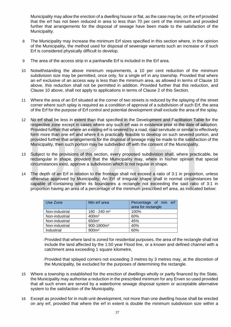
37
Municipality may allow the erection of a dwelling house or flat, as the case may be, on the erf provided that the erf has not been reduced in area to less than 70 per cent of the minimum and provided further that arrangements for the disposal of sewage have been made to the satisfaction of the Municipality.
8 The Municipality may increase the minimum Erf sizes specified in this section where, in the opinion
of the Municipality, the method used for disposal of sewerage warrants such an increase or if such Erf is considered physically difficult to develop.
9 The area of the access strip in a panhandle Erf is included in the Erf area.
10 Notwithstanding the above minimum requirements, a 10 per cent reduction of the minimum
subdivision size may be permitted, once only, for a single erf in any township. Provided that where an erf exclusive of an access way is less than the minimum area, as allowed in terms of Clause 10 above, this reduction shall not be permitted in addition. Provided further that this reduction, and Clause 10 above, shall not apply to applications in terms of Clause 2 of this Section.
11 Where the area of an Erf situated at the corner of two streets is reduced by the splaying of the street
corner where such splay is required as a condition of approval of a subdivision of such Erf, the area of the Erf for the purpose of Erf control and potential development shall exclude the area of the splay.
12 No erf shall be less in extent than that specified in the Development and Facilitation Table for the
respective zone except in cases where any such erf was in existence prior to the date of adoption. Provided further that where an existing erf is severed by a road, road servitude or similar to effectively form more than one erf and where it is practically feasible to develop on such severed portion, and provided further that arrangements for the disposal of sewage may be made to the satisfaction of the Municipality, then such portion may be subdivided off with the consent of the Municipality.
13 Subject to the provisions of this section, every proposed subdivision shall, where practicable, be
rectangular in shape, provided that the Municipality may, where in his/her opinion that special circumstances exist, approve a subdivision which is not regular in shape.
14 The depth of an Erf in relation to the frontage shall not exceed a ratio of 3:1 in proportion, unless
otherwise approved by Municipality. An Erf of irregular shape shall in normal circumstances be capable of containing within its boundaries a rectangle not exceeding the said ratio of 3:1 in proportion having an area of a percentage of the minimum prescribed erf area, as indicated below:
Use Zone Min erf area Percentage of min erf area for rectangle
Non-industrial 180 - 240 m² 100%
Non-industrial 400m² 60%
Non-industrial 650m² 45%
Non-industrial 900-1800m² 40%
Industrial 900m² 60%
- Provided that where land is zoned for residential purposes, the area of the rectangle shall not include the land affected by the 1:50 year Flood line, or a known and defined channel with a catchment area exceeding 1 square kilometre,
- Provided that splayed corners not exceeding 3 metres by 3 metres may, at the discretion of the Municipality, be excluded for the purposes of determining the rectangle.
15 Where a township is established for the erection of dwellings wholly or partly financed by the State,
the Municipality may authorise a reduction in the prescribed minimum for any Erven so used provided that all such erven are served by a waterborne sewage disposal system or acceptable alternative system to the satisfaction of the Municipality.
16 Except as provided for in multi-unit development, not more than one dwelling house shall be erected
on any erf, provided that where the erf in extent is double the minimum subdivision size within a
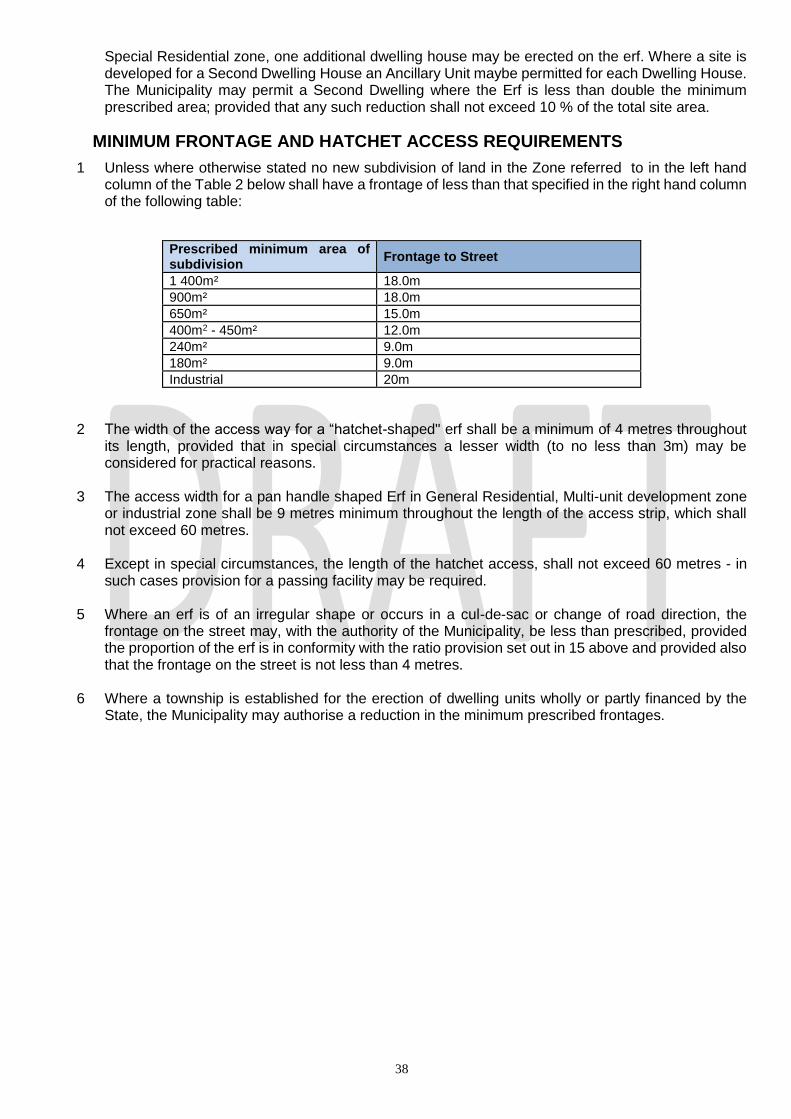
38
Special Residential zone, one additional dwelling house may be erected on the erf. Where a site is developed for a Second Dwelling House an Ancillary Unit maybe permitted for each Dwelling House. The Municipality may permit a Second Dwelling where the Erf is less than double the minimum prescribed area; provided that any such reduction shall not exceed 10 % of the total site area.
MINIMUM FRONTAGE AND HATCHET ACCESS REQUIREMENTS
1 Unless where otherwise stated no new subdivision of land in the Zone referred to in the left hand column of the Table 2 below shall have a frontage of less than that specified in the right hand column of the following table:
2 The width of the access way for a “hatchet-shaped" erf shall be a minimum of 4 metres throughout its length, provided that in special circumstances a lesser width (to no less than 3m) may be considered for practical reasons.
3 The access width for a pan handle shaped Erf in General Residential, Multi-unit development zone or industrial zone shall be 9 metres minimum throughout the length of the access strip, which shall not exceed 60 metres.
4 Except in special circumstances, the length of the hatchet access, shall not exceed 60 metres - in
such cases provision for a passing facility may be required.
5 Where an erf is of an irregular shape or occurs in a cul-de-sac or change of road direction, the frontage on the street may, with the authority of the Municipality, be less than prescribed, provided the proportion of the erf is in conformity with the ratio provision set out in 15 above and provided also that the frontage on the street is not less than 4 metres.
6 Where a township is established for the erection of dwelling units wholly or partly financed by the
State, the Municipality may authorise a reduction in the minimum prescribed frontages.
Prescribed minimum area of subdivision
Frontage to Street
1 400m² 18.0m
900m² 18.0m
650m² 15.0m
400m2 - 450m² 12.0m
240m² 9.0m
180m² 9.0m
Industrial 20m
39
SECTION 5: FLOOR AREA, COVERAGE AND
HEIGHT
5.1. FLOOR AREA RATIO
5.1.1 In calculating floor area of any development, the following shall be excluded:
(a) any basement used exclusively for the parking of motor vehicles and service installations; (b) private garages, carports and covered parking (c) in the case of fuelling and service stations, the areas covered by canopies; (d) staircases, lift shafts/lift motor rooms and service installations, other than on one floor; (e) corridors that are open to the elements on at least one side; (f) Porte cocheres; (g) Balconies, verandahs, porches and similar type of structures that are roofed but open to the
elements on at least one side. (h) ABLUTIONS for use by the public are provided within a shopping complex, either as a
separate building or as part of a building where access thereto is from a shopping mall,
arcade or the like or from a parking area or other open area accessible to the public;
5.1.2. In the case of the Parking Districts as provided for in sub-section 8.6 of this Scheme and not
withstanding any provisions of this Scheme:
i) In Parking District A, any parking provided shall be included as part of the Floor area
calculations applicable to the site;
ii) In Parking District B, any parking provided shall not be included as part of the floor area
calculations for a site within all zones; provided that in the case of General Business (Central)
Zone, parking provided shall be included as part of the floor area applicable to the site;
provided further that within the General Business (Central) Zone an amount representing not
more than 20% of the total permissible floor area shall not be taken into account where such
amount is intended to be used for the parking of motor vehicles; and In Parking District C any
parking provided shall not be included in the floor area calculations applicable to the site.
5.2 COVERAGE
5.2.1 In calculating the coverage of any development, the following shall be excluded:
(a) permeable carports;
40
(b) in the case of fuelling and service stations, the areas covered by canopies which provide
protection to the pump islands;
(c) pergolas;
(d) slatted timber decks;
(e) uncovered swimming pools; (within the natural or finished ground level)
(f) tennis courts;
(g) roof overhangs not exceeding 1.0 metre, provided that should roof overhangs exceed 1.0
metres, the full extent of the roof overhang shall be included into coverage;
(h) An awning providing protection at ground floor level, not greater than 40m2, ancillary to
a residential use; which does not adversely affect the amenities of the neighbourhood;
shall not be taken into account when calculating coverage. However, an awning providing
protection to an elevated patio, verandah, balcony or corridor, shall be taken into account
when calculating coverage;
(i) A carport (used for the garaging of motor vehicles), not greater than 40m2, ancillary to a
residential use, free of walls on two sides and does not adversely affect the amenities of
the neighbourhood, shall not be taken into account when calculating coverage.
5.2.2 Notwithstanding the requirements in respect of floor area and coverage, the Municipality may in special circumstances authorise by special consent the erection of a building of a greater floor area and/or coverage, if it is satisfied that such greater bulk will not result in any significant detriment to the amenities of the area and furthermore that the general intent of the floor area and coverage restrictions imposed within the particular zone is not being deliberately circumvented by such application.
5.2.3 Notwithstanding the provisions of this sub-subsection:
the Municipality may disregard any garage or portion of any other building which, whether by
reason of the topography of the site or not, is erected below the level of the ground, where it
considers that there will be no interference with the amenities of the area existing or as
contemplated by this Scheme; provided that such garage or portion of any other building is
covered over to its satisfaction;
5.3 HEIGHT
5.3.1 The maximum permitted height shall be provided for in Section 7: Development Facilitation
Tables of this Scheme. In calculating the height for any building.
(a) No part of any building on a site in a General Business (Central), General Residential 5,
Education 3 or Cultural and Entertainment Zones or on a site zoned for Government or
Municipal purposes situated on Sea View Street shall project above a line drawn at an angle
of 590 to the horizontal from a point at street level on the opposite boundary of any street
which the site upon which the building is situated has frontage; provided that the Municipality
may by Special Consent authorise a lift motor room or lift tower, an electricity transformer and
meter room, a mechanical ventilation or air-conditioning plant room, a water tank and any
architectural or structural feature of the building to project above the 590 angle line.
(b) In the case of any building on a corner site fronting onto streets of different widths, the line
referred to in paragraph (a) hereof, shall be drawn as aforesaid provided that in respect of the
first 30, 0 metres of the frontage along the narrower street, measured from the street corner,
the said line shall be drawn as if the width of such narrower street was that of the wider street.
(c) The provisions of paragraph (a) and (b) hereof shall not apply: -
41
(i) to that part of a building having frontage to a vehicular street which, from a height of 15,0
metres or less above street level, is set back for its full remaining height a distance not
less than 5,0 metres from any building line, or where there is no building line from the
boundary of any road reserve (existing or as contemplated in terms of this Scheme) to
which the building will have frontage provided that every such setback shall, unless the
Head: Development Planning, Environment and Management otherwise directs, extend
over the whole length of such frontage; to that portion of a building which fronts a non-
vehicular street to the extent that compliance with such provisions along any frontage to
a vehicular street is not affected;
(i) where the Municipality has agreed to the encroachment of a building above any street,
existing or as contemplated in terms of this Scheme, to such portion of such building and,
if the encroachment is to the full width of such street, to such portion of any building
directly facing the encroaching building on the opposite side of such street, as the
Municipality in its absolute discretion may determine; Provided that no such building may,
without the Special Consent of the Municipality be built to a height which exceeds 110.0m.
(d) For the purpose of this sub-section:-
(i) no street shall be regarded as being less than 9,0 metres, or more than 30,0 metres wide;
and
(ii) the street level shall be deemed to be the mean pavement level adjacent to the building
concerned.
By Special Consent:-
1. in the case of a zone referred to in (a) or (b) above, authorise on a sloping site the erection of a building which is more than three storeys in height if such building will at no point have more than two storeys in a vertical line or the erection of a building which is three storeys in height; provided that the Council may exempt an applicant from applying for special consent; provided further, that the prior written consent of the registered owner of each adjoining property and such other properties as the Council may direct, has first been obtained.
2. in the case of a zone referred to in (c) above, authorise the erection of a building more than three storeys in height.
3. in the case of a zone referred to in (d) above, authorize on a sloping site the erection of a building which is 3 storey’s in height; provided that the council may exempt an applicant from applying for special consent; provided further, that the prior written consent of the registered owner of each adjoining property and such other property as the council may direct has first been obtained.
5.3.2 Notwithstanding the requirements in respect of height, the Municipality may authorise by special consent the erection of a building of a greater height, if it is satisfied that such greater height will not result in any significant detriment to the amenities of the area, that such greater height is reasonable having regard to the topography and/or the uniqueness of the site and furthermore that the general intent of the height restriction imposed within the particular zone is not being deliberately circumvented by such application.
The floor area, coverage and height controls shall apply to the overall parent erf and not to the
individual curtilages within a multi-unit development unless specifically stated to the contrary. Unless otherwise agreed, the individual curtilages shall have a maximum floor area and coverage based on the mean per curtilage of that allowed for the overall development.
5.3.3 THE BEACH ZONE
(1) For the purposes of this Scheme, the Beach Zone shall include:

42
(i) All land which is zoned Beach in terms of this Scheme; (ii) The beach north of the southern bank of the Umgeni River; and (iii) The beaches of the Bluff and Merewent.
(2) The height requirements pertaining to the Beach District are provided under Section
7: Development Facilitation Table: Additional Development Parameters within the Beach Zone.
SECTION 6: RESERVATION OF LAND
1.
USE FOR WHICH LAND IS RESERVED
COLOUR NOTATION
REMARKS
New Roads/Widening Solid Red Proposed Reservations for New Roads and widening of existing roads as shown on the scheme map(s) shall become effective at dates to be determined.
Environmental Conservation Reserve
Dark Green with White Hatch
SCHEME INTENTION:
Publically owned land dedicated to the conservation and management of natural areas of land and/or water for the ecosystem services that the areas provide and the biodiversity which they support. 1. Within an Environmental Conservation Reserve, unless
with the prior written authorization from the Municipality in consultation with the Deputy Head: Environmental Planning and Climate Protection.
1.1 No earthworks, sand winning, mining, development or the erection of any structure, including but not restricted to buildings, fencing, swimming pools, wastewater and storm water infrastructure (including evapo-transpiration areas for on-site sanitation), roads, tracks, driveways, walking or cycling trails, or dams, shall be permitted;
1.2 No landscaping or planting of any vegetation, unless it is a requirement for the rehabilitation of the environment in terms of an approved management plan shall be permitted;
1.3 No harvesting, collecting, cutting, hunting or otherwise damaging of flora or fauna and soil and water resources, shall be permitted;
1.4 No vehicles, motorized or non-motorized, other than on established roads, driveways or tracks, shall be permitted.
1.5 No pets or other domestic animals shall be permitted. 1.6 No use of the land, by virtue of the activities of that use, which may be detrimental to the intentions of this Reservation, shall be permitted.
MARKET (former SZ50 and SZ54)
Black cross hatch with number
Within this zone the following conditions shall apply :- 1. The site shall not be used for any purpose other than a
market.

43
TBC 2. No buildings may be erected on the site other than those
considered by the Municipality to be ancillary to the use referred to in condition 1 above.
3. Off-street parking of vehicles shall be provided to the
satisfaction of the Municipality. 4. Vehicular and pedestrian ingress and egress shall be
provided to the satisfaction of the Municipality. 5 In the market situated in Chatsworth on Site 491 on Rem of
Erf 107 Chatsworth, the loading and off-loading of vehicles shall be carried out on the frontages to Chatscross Street and Fragrance Street only.
Mansel Road project The purpose of this zone is to provide parking bays for buses and taxis, ablution and overnight rest facilities for bus and taxi drivers and shopping areas, storage facilities and residential accommodation for traders. 1.the following shall be applicable to land to the east of Mansel Road described as Slater No. 16127, South S.A.R. No. 3 African and portion of Rem of S.A.R. Block WD. 2.The use of the land comprising these sites shall be limited to the following :- (a)the parking of buses and taxis; (b)shops, restaurants and residential accommodation; (c)ablution facilities, rest areas for bus and taxi drivers and storage facilities; (d)any use considered by the Municipality to be ancillary to the uses referred to in paragraphs (a), (b) and (c) or likely to encourage the use of the land comprising these for the purpose described above; (e) any other uses by special consent. 3. Building development shall not exceed 50% coverage of the entire Special 26/02/1998Zone nor 4 storeys in height. 4. Building line, side and rear space provisions shall be to the satisfaction of the Executive Director (Physical Environment); provided that in the case of the rear space adjacent to the boundary of these sites at its interface with the railway tracks, the space proposed shall be referred to the South African Rail Commuter Corporation for approval. 5. The provision of parking for buses and motor vehicles shall be to the satisfaction of the Executive Director (Physical Environment). 6. The land comprising these sites shall be landscaped to the satisfaction of the Executive Director (Physical Environment).
USE FOR WHICH LAND IS RESERVED
COLOUR NOTATION
REMARKS
Public Open Space
Dark Green
• Works as described in the Local Authorities Ordinance No. 25 of 1974, Sections 208 and 264, Sub-Sections (14-20) and 27 are permitted and may include public parks and gardens, recreational grounds, zoological gardens and similar such uses.
River Reserve
Light Blue
• This land is reserved to protect the riverine or water courses in areas immediately adjacent to the above and to minimize pollution and erosion but may be used for passive

44
recreation. All other uses are prohibited. The removal of soil and stones not permitted without the authority of the Municipality.
• The Municipality shall be permitted to install underground services.
Remove from table
Existing Roads White For the purposes of this Scheme:
Shall be reserved for street purposes.
Govt and Municipal Burnt sienna border
(1) Reserved for the use or erection of buildings or facilities of the various tiers of government.
(2) Appropriate provision shall be made for parking
depending on the type of facility.
Reserve Bank (Former SZ34) Black cross hatch with number TBC
The conditions applicable to this site shall be : (a) The land within this zone shall only be developed
for the purpose of the South African Reserve Bank. (b) The site area will be 1ha and will be square with the
southern boundary being the northern boundary of Commercial Road Extension and the western boundary being the eastern boundary of Aliwal Street Extension.
(c) 100% coverage will be permitted up to a maximum
height of 1m above the back of the footpath level and that above this podium the coverage will not exceed 75%.
(d) The height of the building shall not exceed 22m
above podium level in respect of occupiable volume and no portion of the building shall exceed a height of 25m above podium level.
(e) The P.A.R. shall not exceed 4,0.
PARKING GARAGE - CENTRAL PARK (former SZ 42)
Black cross hatch with number TBC
No building other than a Parkade shall be permitted 2. The roof of the Parkade shall be covered by such
depth of soil as will, in the opinion of the Director: Parks be adequate to ensure the use of the area for park and/or recreational purposes.
3. The height of the roof of the garage will be to the
approval of the Development Planning, Management and Environment.
4. The land above the Parkade shall be used for park
and recreational purposes.
TAXI Rank Grey with orange border
Acquisition or development to be negotiated with the owners.
Public Housing Reservation
Orange and yellow cross hatch
1. The purpose of this reservation is solely to allow all spheres of Government to deliver housing, within the Municipality’s jurisdiction.
2. The maximum density permitted is 250du/ha. 3. The Dwelling House/Dwelling Unit shall not be less
than 40m² in extent. 4. Every Dwelling House/Dwelling Unit shall enjoy the
right to contribute to the local economy without impacting on the next. In this regard opportunities for Home Business, Tuck Shop/Spaza Shop, taverns and Bed and Breakfast Establishments shall apply. All such ventures may be permitted by consent of the Municipality.
5. Social facilities shall be provided in accordance with
45
the National Housing Code 2009 together with the Municipality’s own Space Planner. Additional facilities may be called for where required.
6. The development is subject to all other relevant/remaining legislation.
7. Special attention must be given to environmental issues of recycling, planting, use of solar panels, orientation of buildings etc.
8. The building line and side and rear space requirement shall be dictated by Part XA of the National Building Regulations No. 103 of 1977, the Building lines, side and rear spaces are not required for internal subdivisional boundaries in a particular development.
PROCEDURE 1. All successful applicants will prepare a layout for the
Municipality’s consideration. 2. The application will be circulated to all service
providers within and external to the Municipality for comment.
3. This will shape a final layout. At this stage the internal task team will recommend to the Joint Advisory Committee (or any other subsequent committee) for a decision regarding the layout.
4. Building plans may then be submitted for the Municipality’s consideration.
5. An internal task team will monitor the performance of
the reservation and the delivery of housing and may
revise this reservation at any point through a
statutory process.
SPORTS AND RECREATION Light Green with dark Green bands
1. To provide, preserve, use land or buildings for Sports, recreation and stadiums and any other uses ancillary thereto.

46
SECTION 7:
DEVELOPMENT FACILITATION TABLES
ZONE: AIRPORT
SCHEME INTENTION: To provide for:
1. Public and private airport facilities which shall cater for the operation, administration and management of the Airport and
related facilities;
2. Commercial facilities and transient accommodation which cater for the needs of staff and passengers.
MAP COLOUR REFERENCE: Grey and White Bands MAP REFERENCE:
PRIMARY SPECIAL CONSENT PRECLUDED
• Restaurant / Fast Food Outlet
• Action Sports Bar
• Agricultural Land
• Airport
• Arts and Crafts Workshop
• Boarding House
• Car Wash
• Conference Facility
• Conservation Area
• Container Depot
• Crèche
• Display Area
• Educational Establishment
• Flea Market
• Fuelling and Service Station
• Garden Nursery
• Government and Municipal
• Health & Beauty Clinic
• Health Studio
• Hotel
• Industry – Light
• Institution
• Launderette
• Laundry
• Market
• Motor Display Area
• Motor Garage
• Motor Workshop
• Museum
• Nature Reserve
• Base Telecommunications Transmission station
• Betting Depot
• Funeral Parlour
• Industry – General
• Night Club
• Place of Public Entertainment
• Place of Public of Worship
• Recycling Centre
• Special Building
• Utilities Facility
• Any other use authorised in terms of Section 9.4
(Important Buildings and Objects)
• All other uses not
indicated in the Primary
and Special Consent
columns

47
• Office
• Office – Medical
• Parkade
• Pet Grooming Parlour
• Private Open Space
• Shop
• Transport Depot
• Warehouse
ADDITIONAL CONTROLS
1. Parking shall be to be the satisfaction of the Head: EThekwini Transport Authority
DEVELOPMENT PARAMETERS
SPACE ABOUT BUILDINGS DWELLING
UNITS PER
HECTARE
MINIMUM
SUBDIVISION
SIZE (m2)
HEIGHT COVERAGE
FLOOR
AREA
RATIO
BUILDING
LINE SIDE REAR
Not Applicable
ZONE: BRIDGE CITY LAST 4 AMENDMENTS:
09/12/2011 19/10/2018 22/10/2018 16/09/2019
SCHEME INTENTION: Bridge City is to become a dynamic, harmonious and well-balanced precinct of the highest aesthetic, landscape and urban design quality that promotes the notion of African Urbanism. The purpose of the zone is to establish an area which has a strong retail, commercial and residential mix-“Town Centre” with vibrant interactions between urban places (pedestrian lanes, urban squares and parks) and a “Business Estate” which can accommodate a range of contemporary non-impacting business and industrial activities set within a well landscaped environment.
PRECINCT PLAN REFERENCE
TOWN CENTRE (Upper Platform)
19861-BC-P-TC REV 03
BUSINESS ESTATE (Lower Platform)
19861-BC-P-BE REV 03
PRIMARY CONTROLS

48
1. GENERAL 1.1. The following development control principles will act as the critical guiding and managing mechanisms to ensure that the vision for Bridge City
is not jeopardized, but facilitated by: a. The use of defined, detailed Precinct Plans that provide certainty in terms of overall spatial frameworks and primary structuring elements,
broad land use categories, potential minimum and maximum heights and potential minimum and maximum floor area ratios (FAR) supported by the imposition of Urban Design Guidelines, such as Build to Lines, to which all sites must adhere.
b. The management of Development Rights in terms of a " Permitted Floor Area Bank". c. The use of a Design Review Panel to review all development proposals prior to Local Authority approval of Building Plans and to guide the
detailed development on a site by site basis. d. A site- specific Traffic management plan must be prepared, where deemed appropriate and necessary by the eThekwini Transport Authority
(ETA) and contain information such as Ingress, Egress, Loading, parking, vehicle turning radius etc. and upon request by ETA any other necessary site-specific transport requirement and shall be submitted for approval to the Head: eThekwini Transport Authority prior to any development occurring on site.
2. PERMITTED FLOOR AREA BANK 2.1. The total maximum Development Rights (bulk floor area) envisaged for Bridge City is 725 000m2. 2.2. The total amount of Development Rights will be held in a " Permitted Floor Area Bank " which is effectively controlled and managed by the
Effingham Development JV and in conjunction with the Local Authority. 2.3. The Local Authority and the Effingham Development JV shall maintain an accurate and up to date record of both the sale and use of
development rights in a proper and accessible manner, which shall be subject to annual audit by an independent body if deemed necessary by any of the parties.
2.4. The manner in which the Development Rights held in the " Permitted Floor Area Bank" will be sold/transferred/distributed and used will be in accordance with the Precinct Plans.
2.5. Any additional development rights sought, over and above the amount stipulated in 2.1 above, shall be subject to a full Planning Scheme Amendment.
3. PRECINCT PLANS 3.1. Notwithstanding what may be in the Scheme, Urban Design Guidelines, such as build-to-lines, build-within zones, primary and secondary
setbacks, Conceptual Primary Building Zones and Non-user Area’s will be set in the Precinct Plan and are subject to review by the Design Review Panel.
3.2. The Bridge City Zone will be divided into a number of Precincts as may be determined by the Effingham Development JV. 3.3. A Precinct Plan may be comprised of any number of sites. 3.4. The Precinct Plans must be submitted to the Local Authority Head: Development Planning and Management for approval. 3.5. The Precinct Plan shall include site specific details on each of the following, where relevant:
a. Land Use Categories and Controls b. List of sites within the Precinct c. Details of total maximum Development Rights potential d. Max Floor Area Ratios per site e. Max Heights per site f. Coverage details g. Parking provisions and requirements h. Urban Design Guidelines such as arcades, colonnades, building lines, build-to lines and build within zones. i. Indicative side and rear space provisions j. Road network k. Pedestrian streets/squares/spaces l. Indicative landscaping of streetscape m. Development Framework n. Identification of sites requiring specific architectural response o. Identification of important/sensitive features and/or landmarks p. Area’s identified for street trading, if applicable q. Area’s identified for bus/taxi rank and termini and ranking facilities, if applicable r. Area’s identified for public transport facilities, if applicable s. Area’s identified for parking, where applicable t. Areas identified for taxi stops, where applicable u. Indication of where additional details, investigations, approvals, are required v. Additional site-specific design/planting controls where applicable w. Linkages to adjacent/future precincts x. Other specific conditions and features determined through detailed precinct design
4. DESIGN REVIEW PANEL 4.1. A Design Review Panel will be established by the Primary Developer and will be responsible for the review and assessment of all
development proposals in a manner to be determined in consultation with the Development Planning and Management Unit. 4.2. Such review and assessment must lead to the recommendation for approval to the Local Authority, of the required Building Plans. 4.3. The Local Authority will be responsible for approving all Building Plans. The Local Authority will not approve any Building Plan unless it has
been recommended for approval by the Design Review Panel and provided that the relevant Precinct Plan has been approved by the Local Authority.
4.4. The recommendation of Building Plans by the Design Review Panel shall only occur once the purchaser / site developer has adhered to all requirements of this Zone.
5. TRANSPORT AUTHORITY REQUIREMENTS 5.1. Parking provisions are to be applied as follows:
Within the Town Centre (Upper Platform)
Nil minimum on-site requirement
Within the Business Estate (Lower Platform)
I. Mixed Use (any combination of “II” to “VI” below)
1.5 bays per 100m2 of usable building area
II. Commercial 2.5 bays per 100m2 of usable building area
III. Entertainment 3.0 bays per 100m2 of usable building area
IV. Government/ Municipal/ 1.0 bays per 100m2 of usable building area

49
/Institution
V. Light Industry 1.0 bays per 100m2
VI. Residential Dwelling/Flat 0.5 bays per unit
5.2. A nil minimum parking requirement has been established in the Town Centre, as an incentive for all sites highlighted on the attached plan-
reference SCP1. It is recommended that the purchaser consider the following when determining the parking requirement; loading / unloading, visitors’ parking and service / emergency vehicles.
6. ZONE CONTROLS 6.1. FAR
a. A minimum FAR for any site shall be as indicated on the relevant Precinct Plan as approved by the Head : Development Planning, Environment & Management from time to time.
b. Notwithstanding anything to the contrary in the Scheme, parking areas, basement (covered and uncovered) shall not be included in FAR and coverage calculations.
c. Notwithstanding anything to the contrary in the Scheme, awnings, canopies, arbours, colonnades, balconies, within the sidewalk area shall not be included in coverage and FAR calculations.
6.2. HEIGHT a. The height of any development within the Special Zone is as determined in the Precinct Plans. b. Height is calculated from the median natural ground level of the site to the top of the highest storey. c. A basement shall be included in the height envelope to the extent it exceeds the median height natural ground level of the site. d. Height in the Town Centre is unrestricted, however, should the overall Precinct exceed the prescribed Development Rights for Bridge
City then an application by the Effingham Development JV to amend the development rights must be submitted to the Head: Development Planning, Environment and Management.
e. Height in the Business estate is as per the Precinct Plan. f. In the case of the Business Estate, height may be increased by way of a Special Consent application motivated by the Design Review
Panel and subject to the approval by the Head: Development Planning, Environment and Management.
6.3. BUILDING LINES: a. All sites shall have a zero metre (0m) building line imposed on all sides however cognizance must be taken for DoT and mandatory
building lines on respective sites, as shown on the precinct plans.
6.4. SERVITUDES: a. All servitudes and descriptions are contained in respective Precinct Plans. b. Urban space servitude (Applies to erven 36, 54, 74 & 91 only): • Ownership shall be private or local authority. • Subject to piazza lane, landscaping, underground parking and right of way servitudes in favour of the management association. • Public services may only be constructed on public/private urban space sites with consent of the management association. • Pedestrian Bridges over public/private urban space sites may be constructed with the consent of the management association. • Access to emergency and light delivery vehicles only.
USE CATEGORY: TOWN CENTRE
USE CATEGORY INTENTION: The Town Centre is an area which has a strong retail, commercial and residential mix. The intention of this Use Category is to regulate the types of development that are to be located within the Town Centre.
PRIMARY SPECIAL CONSENT PRECLUDED
Action Sports Bar Adult Premises Arts and Craft Workshop Betting Depot Car Wash Convention Center Crèche (see additional control note 3 below) Educational Establishment Escort Agency Flat Flea Market Fueling and Service Station (see additional control note 4 below) Government/Municipal Health and Beauty Clinic Health Studio Hotel Institution Laundry Motor Display Area
Agricultural Land (see additional control note 5 below pertaining to small market garden allotments) BTTS* Special Building
Agricultural Activity Boarding House Builders Yard Cemetery Crematorium Chalet Development Conservation Area Container Depot Correctional Facility Direct Access Service Centre Display Area Dwelling House Forensic Science Laboratory Funeral Parlour Garden Nursery Industry: Extractive Industry: General Industry: General Industry: Light Industry: Noxious Landfill

50
Multiple Unit Development Museum Night Club Office Office: Medical Parkade Pet Grooming Parlor Place of Public Entertainment Place of Public Worship Private Open Space Public Open Space Restaurant/Fast Food Outlet Retirement Centre Shop Veterinary Clinic
Mobile Home Park and Camping Ground Mortuary Motor Garage Motor Vehicle Test Centre Motor Workshop Nature Based Recreation and Tourism Nature Reserve Recycling Centre Reform School Refuse Disposal Restricted Building Riding Stables Scrap Yard Transport Depot Truck Stop Warehouse Zoological Garden
ADDITIONAL CONTROLS
1. BTTS = Base Telecommunication Transmission Station 2. A nil minimum parking requirement will apply within the Town Centre-see reference plan SCP1. 3. A Crèche can serve as an ancillary use to a primary or special consent use subject to the discretion of the Head: Development
Planning, Environment and Management. 4. Fueling and Service Station* - A Fueling and Service Station will only be allowed on selective sites, as defined in the respective precinct
plans. 5. Market sites for urban agriculture will be permitted on selective sites within the Town Centre, as defined in the respective precinct plans. 6. Informal trading areas/zones will be permitted on selective sites within the Town Centre, as defined in the respective precinct plans. 7. All applications that are proposed for the Bridge City development will be subject to a review by the Design Review Panel i.e. includes
both primary and special consent applications.
DEVELOPMENT PARAMETERS
SPACE ABOUT BUILDINGS DWELLING UNITS PER HECTARE
MINIMUM ERF SIZE
HEIGHT IN STOREYS
COVERAGE
FLOOR
AREA RATIO BUILDING
LINE SIDE REAR
See Building Line note 6.3
N/A N/A Unrestricted 80% Building coverage
100% Basement coverage for
parking purposes only
Min FAR as per precinct plan.
No Restriction on max FAR.
USE CATEGORY: BUSINESS ESTATE
USE CATEGORY INTENTION: The Business Estate” can accommodate a range of contemporary non- impacting business and industrial activities set within a landscape environment. The intention of this Use Category is to regulate the types of development that are to be located within the Business Estate.
PRIMARY SPECIAL CONSENT PRECLUDED
Action Sports Bar Adult Premises Arts and Craft Workshop Betting Depot Builders Yard Car Wash Convention Centre Crèche (see additional control note 3 below) Educational Establishment Escort Agency Flat Flea Market
BTTS* Display Area Garden Nursery Museum Special Building
Agricultural Activity Agricultural Land Boarding House Cemetery/Crematorium Chalet Development Conservation Area Container Depot Correctional Facility Direct Access Service Centre Dwelling House Forensic Science Laboratory Fueling and Service Station
51
Funeral Parlour Government and Municipal Health and Beauty Clinic Health Studio Hotel Industry: Light Institution Laundry Mortuary Motor Display Area Motor Garage Motor Vehicle Test Centre Motor Workshop Multiple Unit Development Night Club Office Office: Medical Parkade Pet Grooming Parlour Place of Public Entertainment Place of Public Worship Private Open Space Public Open Space Recycling Centre (see additional control note 4 below) Restaurant/Fast food outlet Shop Veterinary Clinic Warehouse
Industry: Extractive Industry: General Industry: Noxious Landfill Mobile Home Park and Camping Ground Nature Based Recreation and Tourism Nature Reserve Reform School Refuse Disposal Restricted Building Retirement Centre Riding Stables Scrap Yard Transport Depot Truck Stop Zoological Garden
ADDITIONAL CONTROLS
1. BTTS = Base Telecommunication Transmission Station 2. Parking within the Business Estate Zone is as per item 5.1. Please see reference plan SCP1. 3. A Crèche can serve as an ancillary use to a primary or special consent use subject to the discretion of the Head: Development
Planning, Environment and Management. 4. A Recycling Centre can serve as an ancillary use to a primary or special consent use subject to the discretion of the Head: Development
Planning, Environment and Management. 5. Informal trading areas/zones will be permitted on selective sites within the Business Estate, as defined in the respective precinct plan. 6. All applications that are proposed for the Bridge City development will be subject to a review by the Design Review Panel i.e.
includes both primary and special consent applications.
DEVELOPMENT PARAMETERS
SPACE ABOUT BUILDINGS
DWELLING UNITS PER HECTARE
MINIMUM ERF SIZE
HEIGHT IN STOREYS
COVERAGE
FLOOR
AREA
RATIO BUILDING LINE
SIDE REAR
See Building Line note 6.3 N/A N/A
5 Storey
(21m height envelope)
100% max building
coverage
Min FAR as per precinct plan.
Max FAR 1.0 and1.5 See precinct plan

52
ZONE: BEACH
SCHEME INTENTION: To :--
• promote and use the sea shore in a sustainable manner and as part of broader coastal management,
• provide a mix of uses which permits recreational, pleasure, tourism and commercial activities, and
• preserve the open character of the beach zone through the appropriate use of scale and positioning of development.
MAP COLOUR REFERENCE: Orange Dots on White background MAP REFERENCE:
PRIMARY SPECIAL CONSENT PRECLUDED
• Action Sports Bar
• Beach Amenity Facility
• Garden Nursery
• Conservation Area
• Flea Market
• Government / Municipal
• Health Studio
• Museum
• Nature Reserve
• Nature-Based Tourism
• Place of Public Entertainment
• Restaurant / Fast Food outlet
• Shop
• Utilities Facility
• Zoological Garden
• Museum
• Base Telecommunications Transmission Station
• Conference Facility
• Mobile Home Park & Camping Ground
• Night Club
• Special Building
• Any other use authorised in terms of Section 9.4 (Important Buildings and Objects)
• All other uses not indicated in
the Primary and Special
Consent columns
ADDITIONAL CONTROLS - LAND USE
1. Parking shall be in accordance with Section 8 of this scheme.
DEVELOPMENT PARAMETERS
SPACE ABOUT BUILDINGS DWELLING UNITS PER HECTARE
MINIMUM
SUBDIVISION(m2) HEIGHT
PARKING COVERAGE
FLOOR
AREA
RATIO
BUILDING LINE
SIDE REAR
Nil Nil
To the discretion
of the Municipality
N/A N/A
Refer to additional
development parameters
below
Parking provided by
the Municipality
N/A N/A
ADDITIONAL CONTROL - DEVELOPMENT PARAMETERS
Height:
The following height provisions shall apply to the Beach Zone: (a) Notwithstanding the provisions of (a), (b) and (c) hereof, the following shall be permitted:
(i) Masts, poles or towers of a decorative or functional nature shall be permitted provided that they are not designed to be occupied and do not exceed a height of 50.0m above mean sea level; and
(ii) Lifeguard towers and ancillary facilities inclusive of ablutions and administrative offices. (b) The Municipality may authorise the erection of a building or structure to a greater height than stipulated in
above/below regulations, if it considers that the proposed building or structure will be so situated in relation to any existing building or structure, topography or established vegetation that there will be no additional adverse visual impact, or if the Municipality considers that the proposed building or structure will have an insignificant or minor visual impact and such building or structure will provide a useful public amenity. Provided that any such application shall be supported by an analysis of actual sea views in the area where the building is to be sited, with a graphic impression of the proposal illustrating the potential visual impact thereof.
(c) In respect of (c)(ii) and (e) above, the Municipality may at its discretion, require application for Special Consent in order that public comment may be obtained and taken into account.
(d) The two North beach restaurant buildings have fixed height limits based on a beach development, i.e. 12.9m and

53
12.4m respectively
ZONE: CEMETERY
SCHEME INTENTION: To provide and use land or buildings for private or public cemetery purposes and uses ordinarily ancillary thereto.
MAP COLOUR REFERENCE: Dark Green Cross- hatch MAP REFERENCE:
PRIMARY SPECIAL CONSENT PRECLUDED
• *Dwelling House
• Cemetery/Crematorium • Funeral Parlour
• Government / Municipal
• Place of Public Worship
• Base Telecommunications Transmission
Station
• Mortuary
• Museum
• Special Building
• Any other use authorised in terms of Section 9.4 (Important Buildings and Objects)
• All other uses not indicated in the Primary and
Special Consent columns
ADDITIONAL CONTROLS
All landscaping at the discretion of the eThekwini Municipality.
*A Dwelling House may be permitted to accommodate a manager, foreman, caretaker or security personnel.
DEVELOPMENT PARAMETERS
SPACE ABOUT BUILDINGS DWELLING UNITS PER HECTARE
MINIMUM SUBDIVISION
SIZE(m2) HEIGHT COVERAGE
FLOOR AREA RATIO
BUILDING LINE
SIDE SPACE
REAR SPACE
7.5m 3.0m (at the
discretion of the Head:DPEM)
4.5m (at the
discretion of the
Head:DPEM)
N/A To the discretion
of the Municipality 2 (previously
N/A) N/A N/A

54
ZONE: CONSERVATION
SCHEME INTENTION: A Conservation Zone is land (other than publicly owned land) dedicated to the conservation and management of natural areas of land and/or water for the ecosystem services that the areas provide and the biodiversity which they support and/or areas with scenic beauty, indigenous flora & fauna, water courses, topographical features and places of historic or scientific interest. MAP COLOUR REFERENCE: Pale Green with “CZ” in black bold MAP REFERENCE:
PRIMARY SPECIAL CONSENT PRECLUDED
Conservation Area
Nature Based Tourism
• All other uses not indicated in the Primary and Special
Consent columns
ADDITIONAL CONTROLS – LAND USE
Within a Conservation Zone, unless with the prior written approval from the Municipality after consultation with the Deputy Head: Environmental Planning and Climate Protection and within the principles encompassed within the Scheme Intention for this Zone-
1.1 No earthworks, development sand winning, mining or the erection of any structure, including but not restricted to buildings, fencing, swimming pools, wastewater and storm water infrastructure (including evapo-transpiration areas for on-site sanitation), roads, tracks, driveways, walking or cycling trails, or dams, shall be permitted.Any permanent structure may only be permitted on application to, and with the authority of the Municipality and in terms of any conditions which may be imposed.
1.2 No landscaping or planting of any vegetation shall be permitted, unless it is a requirement for the rehabilitation of the environment in terms of a management plan agreed with the Municipality.
1.3 No harvesting, collecting, cutting, hunting or otherwise damaging of flora or fauna and soil and water resources, shall be permitted, unless it is a requirement for the rehabilitation of the environment in terms of a management plan agreed with the Municipality.
1.4 The use of vehicles, motorised or non-motorised, shall be permitted with the written permission of the Municipality, in consultation with the Municipality’s
Environmental Planning and Climate Protection Department. 1.5 No domesticated animals shall be permitted unless written authority for their presence on a site zoned for Conservation purposes, has been granted 1.6 No use of the land which may, by virtue of the activities of that use, be contrary to the intentions of this Zone, shall be permitted. 2. Within a zone which flanks a Conservation Zone that forms part of the same parent erf, the area of the Conservation Zone portion may, by Special Consent, be taken
into account in calculating the total potential permitted in terms of floor area, coverage, height, and density, on the portion zoned for development, provided that: 2.1 this does not, in the view of the Municipality, compromise the overall development of the erf or interfere with the amenities of the area, existing or as contemplated by
the Scheme, and 2.2 a 25 metre non-building buffer to the Conservation Zone portion shall be observed where such clustering occurs. 2.3 the exclusions from developable area, such as land which is:- (i) oversteep, (ii) geo-technically unstable, (iii) subject to flooding, (iv) inaccessible, (v) affected by servitudes, or any other exclusions as determined by the Municipality, shall apply in determining the theoretical potential over the entire site. 3. The Municipality may, at its discretion and in consultation with the Deputy Head: Environmental Planning and Climate Protection, exempt an applicant from applying
for the Special Consent where: - 3.1 a 25 metre non-building buffer requirement is sought to be relaxed or dispensed with; 3.2 the transference of floor area, coverage, height and/or unit potential from a conservation zoned portion to a residential zoned portion of an erf is
sought; 3.3 a smaller erf size than the designated zone minimum erf size is sought in the non-conservation zone portion and may be permitted under certain circumstances
pertaining to that zone provided that the prior written consent of the registered owners of each adjoining and opposite properties to the site and such other properties as the Municipality, in consultation with the Deputy Head: Environmental Planning and Climate Protection, may direct, has first been obtained.
4. The uses related to Nature-Based Recreation and Tourism shall be at the discretion of the Municipality in consultation with the Deputy Head: Environmental Planning and Climate Protection provided that such uses shall not conflict with the intent of this zone, provided further that they may include hides, viewing platforms and visitor's centres used to enlighten the public of the attributes and benefits of the Conservation Zone.
DEVELOPMENT PARAMETERS
SPACE ABOUT
BUILDINGS
DWELLING UNITS PER HECTARE
MINIMUM SUBDIVISI
ON SIZE(m2)
HEIGHT COVERAGE FLOOR AREA RATIO
PARKING ADDITIONAL
DEVELOPMENT PARAMETERS
At the discretion of the
Municipality N/A N/A
1 storey except in the case of hides and viewing platforms.
12,5% for sites less than 1600m² in
extent and 200 m² for sites 1600 m² or greater in
extent
N/A
Parking to be provided on the adjacent
Zone in terms of
Section 8
N/A
55
ZONE: COMMERCIAL
SCHEME INTENTION: To provide, preserve, use land or buildings to accommodate a wide range of recreational, residential, shopping and business or economically related activities in such a way that the site contributes the creation of a harmonious well balanced zone
MAP REFERENCE: Blue
PRIMARY SPECIAL CONSENT PRECLUDED
• Action Sports Bar • Adult Premises
• Arts and Crafts Workshop
• Betting Depot
• Boarding House
• Car Wash
• Conference Facility
• Crèche
• Dwelling House
• Educational Establishment
• Escort Agency
• Flat
• Flea Market
• Funeral Parlour
• Garden Nursery
• Government/ Municipal
• Health & Beauty Clinic
• Health Studio
• Hotel
• Industrial - Light
• Institution
• Laundry
• Market
• Motor Display Area
• Motor Garage
• Motor Vehicle Test Centre
• Motor Workshop
• Museum
• Nature Reserve
• Night Club
• Office
• Offices - Medical
• Pet Grooming Parlour
• Place of Public Entertainment
• Place of Public Worship
• Restaurant/ Fast Food Outlet
• Shop
• Sports and Recreation
• Transport Depot
• Utilities Facility
• Veterinary Clinic
• Warehouse
• Zoological Garden
•Base Telecommunications Transmission Station • Builders Yard • Chalet Development • Fuelling and Service Station • Special Building
• All other uses not indicated in the Primary and Special Consent columns

56
ADDITIONAL CONTROLS
• Parking shall be in terms of Section 8 of this Scheme.
DEVELOPMENT PARAMETERS
SPACE ABOUT BUILDINGS DWELLING
UNITS PER
HECTARE
MINIMUM
SUBDIVISION HEIGHT
COVERAGE
FLOOR AREA
RATIO BUILDING LINE
SIDE & REAR
SPACE
Nil to all roads,
swimming pool 1.0
m, Abutting N2 = 15m
(N/A)
N/A)
900 m²
5
50 %
1.5
57
ZONE: COMMUNITY FACILITY
SCHEME INTENTION:
To provide, preserve, use land or buildings for civic and social requirements of the community in such a way that contributes to the creation of a harmonious and
well balanced environment.
MAP COLOUR REFERENCE: orange Cross Hatch MAP REFERENCE:
PRIMARY SPECIAL CONSENT PRECLUDED
• Convention Centre
• Crèche
• Dwelling House
• Educational Establishment
• Funeral Parlour
• Garden Nursery
• Government / Municipal
• Institution
• Museum
• Place of Public of Worship
• Private Open Space
• Public Open Space
• Retirement Centre
• Veterinary Clinic
• BTTS *
• Cemetery / Crematorium
• Mortuary
• Special Building
• All other uses not indicated in the Primary and
Special Consent columns
ADDITIONAL CONTROLS – LAND USE
1. All landscaping shall to the discretion of the Municipality.
2. BTTS shall mean Base Telecommunications Transmission Station.
3. A Dwelling House may be permitted to accommodate a caretaker, manager or security personnel.
DEVELOPMENT PARAMETERS
SPACE ABOUT
BUILDINGS
SIDE SPACE
REAR SPACE
DWELLING UNITS PER HECTARE
MINIMUM SUBDIVISION
SIZE(m2) HEIGHT COVERAGE
FLOOR AREA RATIO
1.0 m 1.0 m 1.0 m N/A To the
satisfaction of the Municipality
6 80 % N/A

58
ZONE: CRÈCHE
SCHEME INTENTION: To provide and use land or buildings for:
Early learning requirements of children and day time care of children.
Recreational facilities ancillary to an Educational Establishment MAP COLOUR REFERENCE: Orange Cross-hatch with the symbol “C” MAP REFERENCE:
PRIMARY SPECIAL CONSENT PRECLUDED
• Crèche • *Dwelling House • (Place of Worship when
ancillary to a Crèche)
• Base Telecommunications Transmission
Station
• Education Establishment
• Place of Public Worship
• Special Building
• Any other use authorised in terms of Section 9.4 (Important Buildings and Objects)
• All other uses not indicated in the Primary and
Special Consent columns
DEVELOPMENT PARAMETERS
SPACE ABOUT BUILDINGS DWELLING
UNITS PER
HECTARE
MINIMUM
SUBDIVISION
(m2)
HEIGHT COVERAGE FLOOR
AREA RATIO BUILDING
LINE SIDE REAR
7.5m N/A N/A N/A 400 2 storeys 40% N/A
ADDITIONAL CONTROLS
*A Dwelling House may be permitted when ancillary to a Crèche
The swimming pool shall comply with the safety requirements of the Head: Health.
Parking shall be in accordance with Section 8 of this scheme.
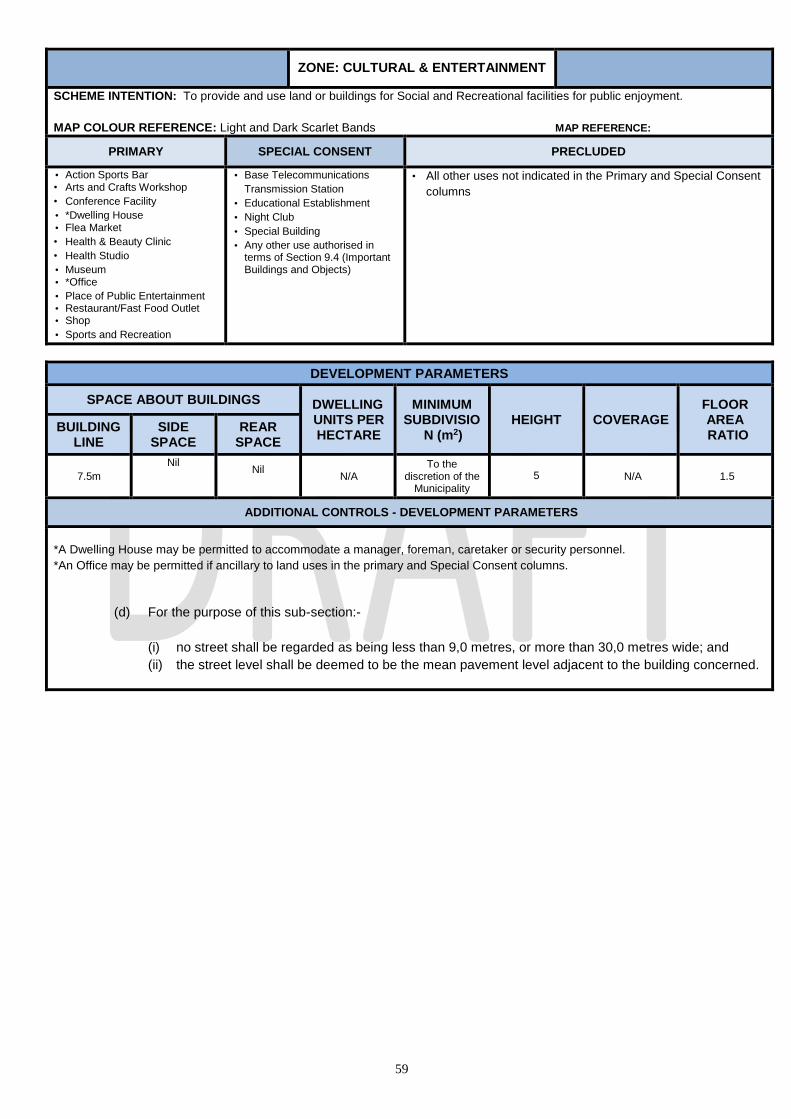
59
ZONE: CULTURAL & ENTERTAINMENT
SCHEME INTENTION: To provide and use land or buildings for Social and Recreational facilities for public enjoyment.
MAP COLOUR REFERENCE: Light and Dark Scarlet Bands MAP REFERENCE:
PRIMARY SPECIAL CONSENT PRECLUDED
• Action Sports Bar • Arts and Crafts Workshop
• Conference Facility
• *Dwelling House • Flea Market
• Health & Beauty Clinic
• Health Studio
• Museum • *Office
• Place of Public Entertainment • Restaurant/Fast Food Outlet • Shop
• Sports and Recreation
• Base Telecommunications
Transmission Station
• Educational Establishment
• Night Club
• Special Building
• Any other use authorised in terms of Section 9.4 (Important Buildings and Objects)
• All other uses not indicated in the Primary and Special Consent
columns
DEVELOPMENT PARAMETERS
SPACE ABOUT BUILDINGS DWELLING UNITS PER HECTARE
MINIMUM SUBDIVISIO
N (m2) HEIGHT COVERAGE
FLOOR AREA RATIO
BUILDING LINE
SIDE SPACE
REAR SPACE
7.5m
Nil
Nil
N/A
To the discretion of the
Municipality
5 N/A 1.5
ADDITIONAL CONTROLS - DEVELOPMENT PARAMETERS
*A Dwelling House may be permitted to accommodate a manager, foreman, caretaker or security personnel.
*An Office may be permitted if ancillary to land uses in the primary and Special Consent columns.
(d) For the purpose of this sub-section:-
(i) no street shall be regarded as being less than 9,0 metres, or more than 30,0 metres wide; and
(ii) the street level shall be deemed to be the mean pavement level adjacent to the building concerned.
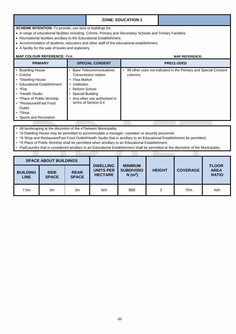
60
ZONE: EDUCATION 1
SCHEME INTENTION: To provide, use land or buildings for:
A range of educational facilities including, Crèche, Primary and Secondary Schools and Tertiary Facilities.
Recreational facilities ancillary to the Educational Establishment.
Accommodation of students, educators and other staff of the educational establishment.
A facility for the sale of books and stationery.
MAP COLOUR REFERENCE: Pink MAP REFERENCE:
PRIMARY SPECIAL CONSENT PRECLUDED
• Boarding House
• Crèche
• *Dwelling House
• Educational Establishment
• *Flat
• *Health Studio
• *Place of Public Worship
• *Restaurant/Fast Food
Outlet
• *Shop
• Sports and Recreation
• Base Telecommunications
Transmission station
• Flea Market
• Institution
• Reform School
• Special Building
• Any other use authorised in terms of Section 9.4
• All other uses not indicated in the Primary and Special Consent
columns
• All landscaping at the discretion of the eThekwini Municipality.
• *A Dwelling House may be permitted to accommodate a manager, caretaker or security personnel.
• *A Shop and Restaurant/Fast Food Outlet/Health Studio that is ancillary to an Educational Establishment be permitted.
• *A Place of Public Worship shall be permitted when ancillary to an Educational Establishment.
• Flat/Laundry that is considered ancillary to an Educational Establishment shall be permitted at the discretion of the Municipality.
SPACE ABOUT BUILDINGS
DWELLING UNITS PER HECTARE
MINIMUM SUBDIVISIO
N (m2) HEIGHT COVERAGE
FLOOR AREA RATIO
BUILDING LINE
SIDE
SPACE
REAR SPACE
7.5m 3m 3m N/A 900 3 75% N/A
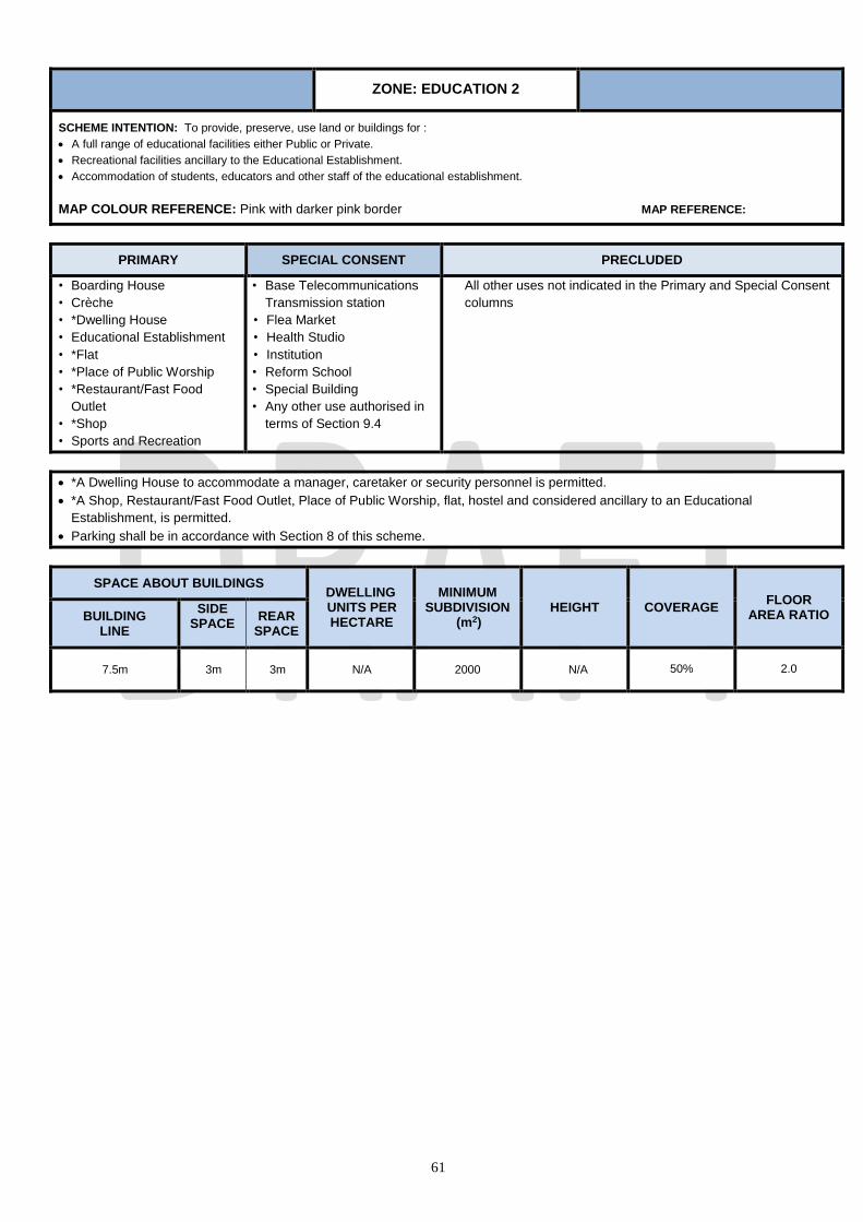
61
ZONE: EDUCATION 2
SCHEME INTENTION: To provide, preserve, use land or buildings for :
A full range of educational facilities either Public or Private.
Recreational facilities ancillary to the Educational Establishment.
Accommodation of students, educators and other staff of the educational establishment.
MAP COLOUR REFERENCE: Pink with darker pink border MAP REFERENCE:
PRIMARY SPECIAL CONSENT PRECLUDED
• Boarding House
• Crèche
• *Dwelling House
• Educational Establishment
• *Flat
• *Place of Public Worship
• *Restaurant/Fast Food
Outlet
• *Shop
• Sports and Recreation
• Base Telecommunications
Transmission station
• Flea Market
• Health Studio
• Institution
• Reform School
• Special Building
• Any other use authorised in
terms of Section 9.4
All other uses not indicated in the Primary and Special Consent
columns
*A Dwelling House to accommodate a manager, caretaker or security personnel is permitted.
*A Shop, Restaurant/Fast Food Outlet, Place of Public Worship, flat, hostel and considered ancillary to an Educational
Establishment, is permitted.
Parking shall be in accordance with Section 8 of this scheme.
SPACE ABOUT BUILDINGS DWELLING UNITS PER HECTARE
MINIMUM SUBDIVISION
(m2) HEIGHT COVERAGE
FLOOR AREA RATIO BUILDING
LINE
SIDE SPACE
REAR SPACE
7.5m 3m 3m N/A 2000 N/A 50% 2.0
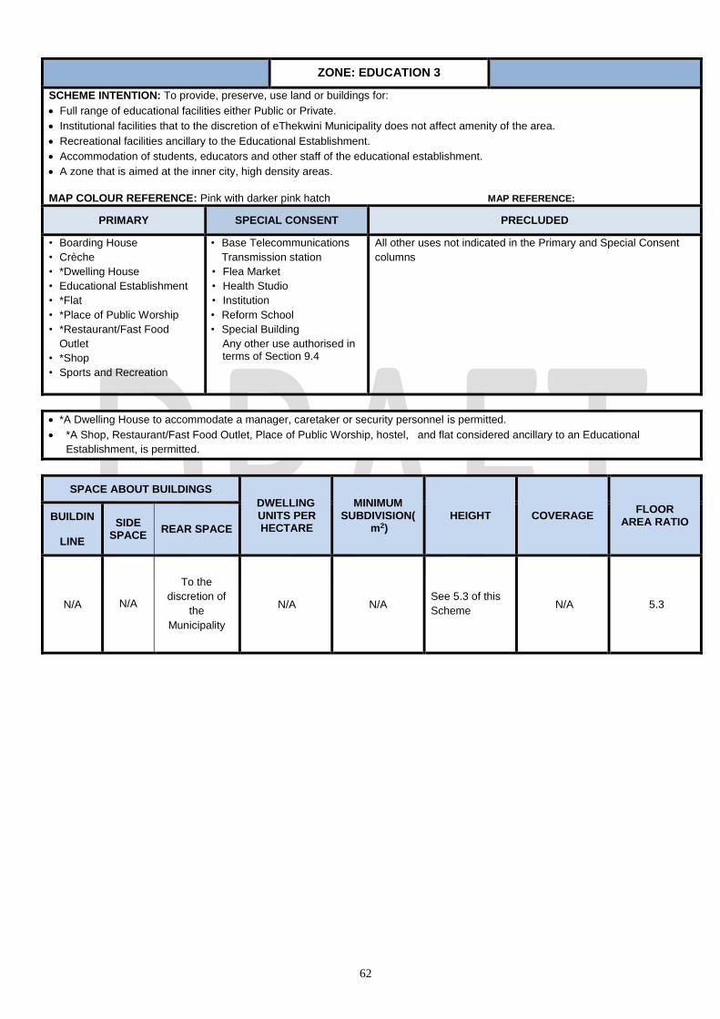
62
ZONE: EDUCATION 3
SCHEME INTENTION: To provide, preserve, use land or buildings for:
Full range of educational facilities either Public or Private.
Institutional facilities that to the discretion of eThekwini Municipality does not affect amenity of the area.
Recreational facilities ancillary to the Educational Establishment.
Accommodation of students, educators and other staff of the educational establishment.
A zone that is aimed at the inner city, high density areas.
MAP COLOUR REFERENCE: Pink with darker pink hatch MAP REFERENCE:
PRIMARY SPECIAL CONSENT PRECLUDED
• Boarding House
• Crèche
• *Dwelling House
• Educational Establishment
• *Flat
• *Place of Public Worship
• *Restaurant/Fast Food
Outlet
• *Shop
• Sports and Recreation
• Base Telecommunications
Transmission station
• Flea Market
• Health Studio
• Institution
• Reform School
• Special Building
Any other use authorised in terms of Section 9.4
All other uses not indicated in the Primary and Special Consent
columns
*A Dwelling House to accommodate a manager, caretaker or security personnel is permitted.
*A Shop, Restaurant/Fast Food Outlet, Place of Public Worship, hostel, and flat considered ancillary to an Educational
Establishment, is permitted.
SPACE ABOUT BUILDINGS
DWELLING UNITS PER HECTARE
MINIMUM SUBDIVISION(
m2)
HEIGHT
COVERAGE
FLOOR AREA RATIO
BUILDING
LINE
SIDE
SPACE
REAR SPACE
N/A N/A
To the
discretion of
the
Municipality
N/A N/A See 5.3 of this
Scheme N/A 5.3

63
ZONE: EXTRACTIVE INDUSTRY
SCHEME INTENTION: To provide, preserve, use land or buildings for:-
the accommodation of a range of industrial process, such as, mining, winning or quarrying of raw materials from the ground, including, gravel, sand, and
stone and includes buildings associated with such operations and crushing plant.
MAP COLOUR REFERENCE: Purple Cross-hatched MAP REFERENCE:
PRIMARY SPECIAL CONSENT PRECLUDED
*Dwelling House
*Office
Industry - Extractive
Sandwinning
Base Telecommunications Transmission Station
Special Building
Any use authorized in terms of Section 9.4
All other uses not indicated in the Primary and
Special Consent columns
ADDITIONAL CONTROLS – LAND USE
1. *A dwelling house and office may be permitted to accommodate a manager, foreman, caretaker or security personnel.
2. Parking shall be in accordance with Section 8 of this scheme.
SPACE ABOUT BUILDINGS DWELLING UNITS PER HECTARE
MINIMUM SUBDIVISION
(m2) HEIGHT COVERAGE
FLOOR AREA RATIO BUILDING
LINE SIDE AND
REAR SPACE
7.5 N/A N/A 900 25.0m N/A
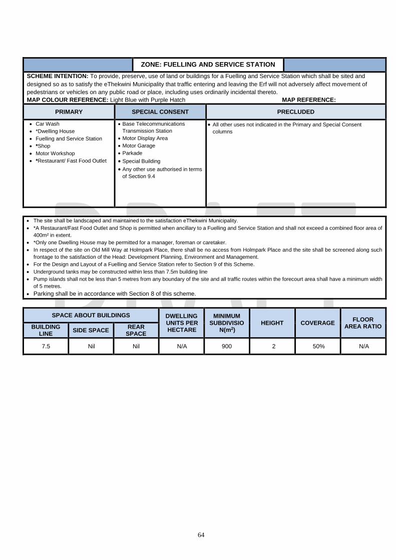
64
ZONE: FUELLING AND SERVICE STATION
SCHEME INTENTION: To provide, preserve, use of land or buildings for a Fuelling and Service Station which shall be sited and
designed so as to satisfy the eThekwini Municipality that traffic entering and leaving the Erf will not adversely affect movement of
pedestrians or vehicles on any public road or place, including uses ordinarily incidental thereto.
MAP COLOUR REFERENCE: Light Blue with Purple Hatch MAP REFERENCE:
PRIMARY SPECIAL CONSENT PRECLUDED
Car Wash
*Dwelling House
Fuelling and Service Station
*Shop
Motor Workshop
*Restaurant/ Fast Food Outlet
Base Telecommunications
Transmission Station
Motor Display Area
Motor Garage
Parkade
Special Building
Any other use authorised in terms
of Section 9.4
All other uses not indicated in the Primary and Special Consent
columns
The site shall be landscaped and maintained to the satisfaction eThekwini Municipality.
*A Restaurant/Fast Food Outlet and Shop is permitted when ancillary to a Fuelling and Service Station and shall not exceed a combined floor area of
400m² in extent.
*Only one Dwelling House may be permitted for a manager, foreman or caretaker.
In respect of the site on Old Mill Way at Holmpark Place, there shall be no access from Holmpark Place and the site shall be screened along such
frontage to the satisfaction of the Head: Development Planning, Environment and Management.
For the Design and Layout of a Fuelling and Service Station refer to Section 9 of this Scheme.
Underground tanks may be constructed within less than 7.5m building line
Pump islands shall not be less than 5 metres from any boundary of the site and all traffic routes within the forecourt area shall have a minimum width
of 5 metres.
Parking shall be in accordance with Section 8 of this scheme.
SPACE ABOUT BUILDINGS DWELLING UNITS PER HECTARE
MINIMUM SUBDIVISIO
N(m2) HEIGHT COVERAGE
FLOOR AREA RATIO BUILDING
LINE SIDE SPACE
REAR SPACE
7.5 Nil Nil N/A 900 2 50% N/A

65
ZONE: GENERAL BUSINESS (CENTRAL)
SCHEME INTENTION: To provide, preserve, use land or buildings for:
• Intense commercial and or business activities.
• Spatial Development and sustainable function of the Central Business District.
• This zone shall apply to the Durban Central Business area demarcated by Figure 1 of Section 8
•
MAP COLOUR REFERENCE: Dark Blue with White Hatch MAP REFERENCE:
PRIMARY SPECIAL CONSENT PRECLUDED
Action Sports Bar
Adult Premises
Arts and Crafts Workshop
Betting Depot
Boarding House
Car Wash
Conference Facility
Crèche
*Dwelling House
Educational Establishment
Escort Agency
*Flat
Flea Market
Funeral Parlour
Garden Nursery
Government/ Municipal
Health & Beauty Clinic
Health Studio
Hotel
Industrial - Light
Institution
Laundry
Market
Motor Display Area
Motor Garage
Motor Vehicle Test Centre
Motor Workshop
Museum
Nature Reserve
Night Club
Office
Offices - Medical
Pet Grooming Parlour
Place of Public Entertainment
Place of Public Worship
Restaurant/ Fast Food Outlet
Shop
Sports and Recreation
Transport Depot
Utilities Facility
Veterinary Clinic
Warehouse
Zoological Garden
Base Telecommunications
Transmission Station
Builders Yard
Cemetery/Crematorium
Correctional Facility
Fuelling and Service Station
Mortuary
*Parkade
Recycling Centre
Reform School
Retirement Centre
Special Building
Any other use authorised in
terms of Section 9.4 (Important
Buildings and Objects)
All other uses not indicated in
the Primary and Special
Consent columns
ADDITIONAL CONTROLS – DEVELOPMENT PARAMETERS
• *Dwelling House/Flat not permitted on the ground floor.
*Parkade:
1. Parking shall be read in conjunction with the Durban CBD Plan (see section 8.6 of this scheme);
2. Within the area indicated on Figure 5 CBD Durban, Parkade shall be permitted subject to the following restriction:
• the site shall have a minimum street frontage of 45.0m;
• there shall be minimum spacing between access point of 45.0m; and
• there shall be a maximum of 450 bays served by each access point.
3. Notwithstanding the provisions of Sub-section 8.5 within District B, bonus bulk shall be applicable and an amount representing not more than
20% of the total permissible floor area (PFA) shall not be taken into account where such amount is to be used for the parking of motor vehicles.
On Erf 11952 Durban a parkade shall be freely permitted.
For additional controls relating to floor area read in conjunction with parking, refer to sub-section 5.1.2 of this scheme.
1. HEIGHT
In calculating the height of any building the following shall be taken into account:
(a) No part of any building on a site in a General Business (Central) Zone shall project above a line drawn at an angle of 590 to the
horizontal from a point at street level on the opposite boundary of any street which the site upon which the building is situated has
frontage; provided that the Municipality may by Special Consent authorise a lift motor room or lift tower, an electricity transformer
and meter room, a mechanical ventilation or air-conditioning plant room, a water tank and any architectural or structural feature of
the building to project above the 590 angle line.
(b) In the case of any building on a corner site fronting onto streets of different widths, the line referred to in paragraph (a) hereof, shall

66
be drawn as aforesaid provided that in respect of the first 30, 0 metres of the frontage along the narrower street, measured from
the street corner, the said line shall be drawn as if the width of such narrower street was that of the wider street.
(c) The provisions of paragraph (a) and (b) hereof shall not apply: -
(i) to that part of a building having frontage to a vehicular street which, from a height of 15,0 metres or less above street level, is set back for its
full remaining height a distance not less than 5,0 metres from any building line, or where there is no building line from the boundary of any
road reserve (existing or as contemplated in terms of this Scheme) to which the building will have frontage provided that every such setback
shall, unless the Head: Development Planning, Environment and Management otherwise directs, extend over the whole length of such
frontage;
(ii) to that portion of a building which fronts a non-vehicular street to the extent that compliance with such provisions along any
frontage to a vehicular street is not affected;
(iii) where the Municipality has agreed to the encroachment of a building above any street, existing or as contemplated in terms
of this Scheme, to such portion of such building and, if the encroachment is to the full width of such street, to such portion of
any building directly facing the encroaching building on the opposite side of such street, as the Municipality in its absolute
discretion may determine;
provided that no such building may, without the Special Consent of the Municipality be built to a height which exceeds
110.0m.
(d) For the purpose of this sub-section:-
(i) no street shall be regarded as being less than 9,0 metres, or more than 30,0 metres wide; and
(ii) the street level shall be deemed to be the mean pavement level adjacent to the building concerned.
2. Parking shall be in accordance with Figure 1 of Section 8 of this scheme.
SPACE ABOUT BUILDINGS DWELLING
UNITS PER
HECTARE
MINIMUM SUBDIVISION
(m2) HEIGHT COVERAGE
FLOOR AREA RATIO BUILDING LINE
SIDE AND
REAR SPACE
Nil Nil N/A 240m2
59o angle from
opposite side of street
(max. width 30m) or
110m with a 5.0m
setback at 15.0m
N/A 8.0
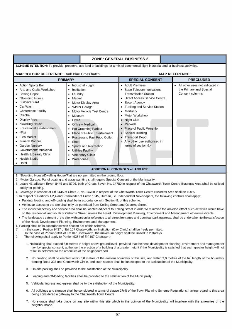
67
ZONE: GENERAL BUSINESS 2
SCHEME INTENTION: To provide, preserve, use land or buildings for a mix of commercial, light industrial and or business activities.
MAP COLOUR REFERENCE: Dark Blue Cross hatch MAP REFERENCE:
PRIMARY SPECIAL CONSENT PRECLUDED
Action Sports Bar
Arts and Crafts Workshop
Betting Depot
*Boarding House
Builder’s Yard
Car Wash
Conference Facility
Crèche
Display Area
*Dwelling House
Educational Establishment
*Flat
Flea Market
Funeral Parlour
Garden Nursery
Government/ Municipal
Health & Beauty Clinic
Health Studio
Hotel
Industrial - Light
Institution
Laundry
Market
Motor Display Area
*Motor Garage
Motor Vehicle Test Centre
Museum
Office
Office – Medical
Pet Grooming Parlour
Place of Public Entertainment
Restaurant/ Fast Food Outlet
Shop
Sports and Recreation
Utilities Facility
Veterinary Clinic
Warehouse
Adult Premises
Base Telecommunications
Transmission Station
Direct Access Service Centre
Escort Agency
Fuelling and Service Station
Mortuary
Motor Workshop
Night Club
Parkade
Place of Public Worship
Special Building
Transport Depot
• Any other use authorised in
terms of section 9.4
All other uses not indicated in
the Primary and Special
Consent columns
ADDITIONAL CONTROLS – LAND USE
1. *Boarding House/Dwelling House/Flat are not permitted on the ground floor.
2. *Motor Garage: Panel beating and spray painting shall require Special Consent of the Municipality.
3. Lease 41 adjacent Erven 8445 and 8796, both of Chats Seven No. 14780 in respect of the Chatsworth Town Centre Business Area shall be utilised
solely for parking.
4. Coverage in respect of Erf 8445 of Chats 7, No. 14780 in respect of the Chatsworth Town Centre Business Area shall be 100%.
5. In respect of Portions 1,2,4 and Remainder of Erven 1545, Durban, i.e. Independent Newspapers, the following controls shall apply:
Parking, loading and off-loading shall be in accordance with Section 8. of this scheme.
Vehicular access to the site shall only be permitted from Kolling Street and Osborne Street.
The industrial activity and service area shall be located adjacent to Kolling Street in order to minimise the adverse effect such activities would have
on the residential land south of Osborne Street, unless the Head : Development Planning, Environment and Management otherwise directs;
The landscape treatment of the site, with particular reference to all street frontages and open car parking areas, shall be undertaken to the satisfaction
of the Head: Development Planning, Environment and Management.
6. Parking shall be in accordance with section 8.6 of this scheme. 7. .In the case of Portion 9437 of Erf 107 Chatsworth, an Institution (Day Clinic) shall be freely permitted. 8. .In the case of Portion 9384 of Erf 107 Chatsworth, the maximum height shall be limited to 2 storeys. 9. The following shall apply to Portion 9384 of Erf 107 Chatsworth
1. No building shall exceed 8,0 metres in height above ground level ; provided that the head development planning, environment and management
may, by special consent, authorise the erection of a building of a greater height if the Municipality is satisfied that such greater height will not result in detriment to the amenities of the neighbourhood.
2. No building shall be erected within 5,0 metres of the eastern boundary of this site, and within 3,0 metres of the full length of the boundary
fronting Road 337 and Chatsworth Circle, and such spaces shall be landscaped to the satisfaction of the Municipality. 3. On-site parking shall be provided to the satisfaction of the Municipality. 4. Loading and off-loading facilities shall be provided to the satisfaction of the Municipality. 5. Vehicular ingress and egress shall be to the satisfaction of the Municipality. 6. All buildings and signage shall be considered in terms of clause 27(4) of the Town Planning Scheme Regulations, having regard to this area
being considered a gateway to the Chatsworth Town Centre. 7. No storage shall take place on any site within this site which in the opinion of the Municipality will interfere with the amenities of the
neighbourhood.

68
DEVELOPMENT PARAMETERS
SPACE ABOUT BUILDINGS DWELLING UNITS PER HECTARE
MINIMUM SUBDIVISION(m2
) HEIGHT COVERAGE
FLOOR AREA RATIO
BUILDING LINE
SIDE AND REAR SPACE
N/A 900
25 metres
N/A 2.0
N//A N/A
ZONE: GENERAL BUSINESS 3
SCHEME INTENTION: To provide, preserve, use land or buildings for mixed commercial and office activities.
MAP COLOUR REFERENCE: Dark Blue Cross bands MAP REFERENCE:
PRIMARY SPECIAL CONSENT PRECLUDED
Action Sports Bar
Adult Premises
Arts and Crafts Workshop
Betting Depot
Boarding House
Car Wash
Conference Facility
Crèche
Display Area
*Dwelling House
Educational Establishment
Escort Agency
*Flat
Flea Market
Funeral Parlour
Garden Nursery
Government/ Municipal
Health & Beauty Clinic
Health Studio
Hotel
Industrial - Light
Institution
Laundry
Market
Motor Display Area
*Motor Garage
Motor Vehicle Test Centre
Motor Workshop
Museum
Nature Reserve
Night Club
Office
Offices - Medical
*Parkade
Pet Grooming Parlour
Place of Public Entertainment
Place of Public Worship
Restaurant/ Fast Food Outlet
Shop
Sports and Recreation
Transport Depot
Utilities Facility
Veterinary Clinic
Warehouse
Zoological Garden
Base Telecommunications
Transmission Station
Builders Yard
Cemetery/Crematorium
Correctional Facility
Fuelling and Service Station
Mortuary
Recycling Centre
Reform School
Retirement Centre
Special Building
Any other use authorised in
terms of Section 9.4 (Important
Buildings and Objects)
All other uses not indicated in the
Primary and Special Consent
columns
ADDITIONAL CONTROLS
• *Dwelling House/Flat not permitted on the ground floor.
1. All areas shall be suitably landscaped and maintained to the satisfaction of the Municipality.
Parking:
2. Parking shall be read in conjunction with the Durban CBD Plan in terms of sub-section 8.6 of this scheme;
3. In the case of Kingsmead Office Park any application submitted to the Municipality for consideration shall have the prior approval of the Kingsmead
Office Park Lot Owner Association.
4. On the properties listed below, the conditions that follow shall apply:
• Remainder of Portion 14 of Erf 699, Brickfield - 281 Moses Kotane Road • Portion 28 of Erf 699, Brickfield - 277 Moses Kotane Road • Portion 11 of Erf 699, Brickfield - 265 Moses Kotane Road • Portion 10 of Erf 699, Brickfield - 263 Moses Kotane Road • Portion 7 of Erf 699, Brickfield - 253 Moses Kotane Road • Portion 26 of Erf 700, Brickfield - 249 Moses Kotane Road • Portion 25 of Erf 700, Brickfield - 241 Moses Kotane Road • Portion 24 of Erf 700, Brickfield - 235 Moses Kotane Road • Portion 23 of Erf 700, Brickfield - 233 Moses Kotane Road
Land use and buildings erected in these sites shall be for purposes in accordance with the provisions of this scheme applicable to a General Residential
2 zone, subject to the following conditions:-
(a) Reciprocal right of way servitude of not less than 17.0m in width shall be registered over all of the sites comprising this Zone. (b) The ground floor of a building on a site may be used for shopping purposes provided that :-
(i) the area used for shopping and for purposes ancillary to such shopping, shall not exceed 50% of the coverage permitted for that site; and
(ii) not less than three adjoining sites are used for shopping purposes at the same time. Any area used for shopping purposes in terms of this
condition shall not be taken into account when calculating the area which may be used for residential purposes in accordance with the controls
below.

69
(c) The building line for any part of any building used or to be used for shopping purposes shall be 17.0m of the street line. (d) (i) On-site parking shall be provided to the satisfaction of the Head: Development Planning, Environment and Management in the ratio of 2
bays for every residential unit and 3 bays for every 100m2 of gross shopping floor area.
(i) Access thereto shall be limited to one ingress and one egress point over the combined frontage of the sites being developed.
(ii) A low wall, with gaps, permitting only pedestrian access to the shopping development shall be erected between the ingress and egress points;
and
(iii) Loading facilities shall be provided to the satisfaction of the Head: Development Planning, Environment and Management.
The condition in (d)(i) above may be relaxed at the discretion of the Head: Development Planning, Environment and Management. (e) If it is intended to use a site for shopping purposes and that site adjoins another site being used for shopping purposes the owner of the site to be
used shall ensure, to the satisfaction of the Head: Development Planning, Environment and Management, that at all times persons wishing to
patronise the shops on any site within this zone have free and unrestricted :-
(i) vehicular and pedestrian access to and across his site to the other sites used for shopping; and
(ii) use of the parking provided for the shops on his site and the thoroughfare to that parking;
in order to ensure that the shopping within this Zone constitutes a single co-ordinated and integrated shopping complex.
DEVELOPMENT PARAMETERS
SPACE ABOUT BUILDINGS DWELLING UNITS PER HECTARE
MINIMUM SUBDIVISION(
m2) HEIGHT COVERAGE
FLOOR AREA RATIO
BUILDING LINE
SIDE AND REAR SPACE
N/A
240
7
80%
(open portion of site to be
suitably landscaped)
N/A
N/A N/A
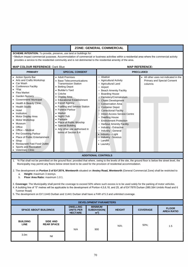
70
ZONE: GENERAL COMMERCIAL
SCHEME INTENTION: To provide, preserve, use land or buildings for:
• Medium impact commercial purposes. Accommodation of commercial or business activities within a residential area where the commercial activity
provides a service to the residential community and is not detrimental to the residential amenity of the area.
MAP COLOUR REFERENCE: Dark Blue MAP REFERENCE:
PRIMARY SPECIAL CONSENT PRECLUDED
Action Sports Bar
Arts and Crafts Workshop
Car Wash
Conference Facility
*Flat
Flea Market
Garden Nursery
Government/ Municipal
Health & Beauty Clinic
Health Studio
Hotel
Institution
Motor Display Area
Motor Workshop
Museum
Office
Office – Medical
Pet Grooming Parlour
Place of Public Entertainment
Shop
Restaurant/ Fast Food Outlet
Sports and Recreation
Veterinary Clinic
Adult Premises
Base Telecommunications Transmission Station
Betting Depot
Builder’s Yard
Crèche
Display Area
Educational Establishment
Escort Agency
Fuelling and Service Station
Funeral Parlour
Market
Night Club
Parkade
Place of Public Worship
Special Building
Any other use authorised in
terms of Section 9.4
• Abattoir
• Agricultural Activity
• Agricultural Land
• Airport
• Beach Amenity Facility
• Boarding House
• Cemetery/Crematorium
• Chalet Development
• Conservation Area
• Container Depot
• Correctional Facility
• Direct Access Service Centre
• Dwelling House
• Environment Protection
• Harbour Amenity Facility
• Industry - Extractive
• Industry - General
Industry – Light • Industry - Noxious
• Landfill
Laundry
All other uses not indicated in the
Primary and Special Consent
columns
ADDITIONAL CONTROLS
1. *A Flat shall not be permitted on the ground floor; provided that where, owing to the levels of the site, the ground floor is below the street level, the
Municipality may permit any floors below street level to be used for the provision of residential accommodation.
2. The development on Portion 3 of Erf 2074, Wentworth situated on Anstey Road, Wentworth (General Commercial Zone) shall be restricted to
a. Height: maximum 3 storeys.
b. Floor Area Ratio: maximum 1.0:1.
3. Coverage: The Municipality shall permit the coverage to exceed 50% where such excess is to be used solely for the parking of motor vehicles.
4. A building line of “0” metres will be applicable to the development of Portion 4,5,6,18, and 25, all of Erf 7878 Durban (580,584 Umbilo Road and 6
Tunmer Road)
5. The development on Erf 11443 Durban and 11441 Durban shall have a FAR of 5.3 and unlimited coverage.
DEVELOPMENT PARAMETERS
SPACE ABOUT BUILDINGS DWELLING UNITS PER HECTARE
MINIMUM SUBDIVISION(
m2) HEIGHT COVERAGE
FLOOR AREA RATIO
BUILDING LINE
SIDE AND REAR SPACE
N/A
900
N/A;
50%;
1.5
3.0m
Nil

71
ZONE: GENERAL INDUSTRY
SCHEME INTENTION: To provide, preserve, use land or buildings for:
Full range of industrial uses where the emphasis is on bulk and heavy industry and where due cognizance must be taken of environmental impacts.
Ensuring sustainable locations for uses which accommodate the requirements for industrial activities and minimize their impact on surrounding uses.
MAP COLOUR REFERENCE: Purple with Dark Purple horizontal Lines MAP REFERENCE:
PRIMARY SPECIAL CONSENT PRECLUDED
• Arts and Crafts Workshop
• Builder’s Yard
• Car Wash
• Display Area
• *Dwelling House
• Government / Municipal
• Industry – General
• Laundry
• Industry – Light
• Motor Display Area
• Motor Garage
• Motor Vehicle Test Centre
• Motor Workshop
• Recycling Centre
• Refuse Disposal
• Direct Access Service Centre
• Fuelling and Service Station
• Funeral Parlour
• Scrap Yard
• Transport Depot
• Truck Stop
• Utilities Facility
• Warehouse
• Action Sports Bar
• Adult Premises
• Base Telecommunications Transmission Station
• Betting Depot
• Cemetery/Crematorium
• Educational Establishment
• Garden Nursery
• Institution
• Mortuary
• Night Club
• Health Studio
• Agricultural Activity • *Office
• *Office – Medical
• Parkade
• Pet Grooming Parlour
• Place of Public Entertainment
• Place of Public of Worship
• Shop
• Restaurant / Fast Food Outlet
• Special Building
• Veterinary Clinic
• Museum
• Any other use authorised in terms of Section 9.4
• All other uses not indicated in the Primary
and Special Consent columns
ADDITIONAL CONTROLS
1. *A Dwelling House may be permitted to accommodate a manager, foreman, caretaker or security personnel.
2. *Offices and *Office-Medical used in conjunction with an industrial use shall be freely permitted.
3. In respect of Portion 1 of Erf 7057 Durban, situated at 56 Calais Road, Congella, a student accommodation use may be permitted with the special
consent of the Municipality.
SPACE ABOUT BUILDINGS DWELLING UNITS PER HECTARE
MINIMUM SUBDIVISION
HEIGHT COVERAGE FLOOR
AREA RATIO BUILDING LINE SIDE AND REAR SPACE
Nil Nil N/A 900 25M N/A N/A
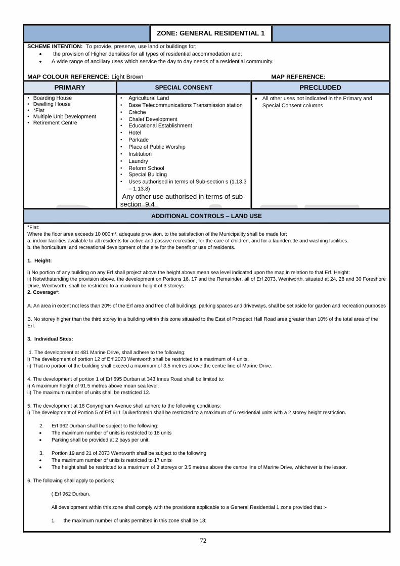
72
ZONE: GENERAL RESIDENTIAL 1
SCHEME INTENTION: To provide, preserve, use land or buildings for;
the provision of Higher densities for all types of residential accommodation and;
A wide range of ancillary uses which service the day to day needs of a residential community.
MAP COLOUR REFERENCE: Light Brown MAP REFERENCE:
PRIMARY SPECIAL CONSENT PRECLUDED
• Boarding House • Dwelling House • *Flat • Multiple Unit Development • Retirement Centre
• Agricultural Land
• Base Telecommunications Transmission station
• Crèche
• Chalet Development • Educational Establishment
• Hotel
• Parkade
• Place of Public Worship
• Institution
• Laundry
• Reform School • Special Building
• Uses authorised in terms of Sub-section s (1.13.3
– 1.13.8)
Any other use authorised in terms of sub-section 9.4
All other uses not indicated in the Primary and
Special Consent columns
ADDITIONAL CONTROLS – LAND USE
*Flat:
Where the floor area exceeds 10 000m², adequate provision, to the satisfaction of the Municipality shall be made for;
a. indoor facilities available to all residents for active and passive recreation, for the care of children, and for a launderette and washing facilities.
b. the horticultural and recreational development of the site for the benefit or use of residents.
1. Height: i) No portion of any building on any Erf shall project above the height above mean sea level indicated upon the map in relation to that Erf. Height:
ii) Notwithstanding the provision above, the development on Portions 16, 17 and the Remainder, all of Erf 2073, Wentworth, situated at 24, 28 and 30 Foreshore
Drive, Wentworth, shall be restricted to a maximum height of 3 storeys.
2. Coverage*:
A. An area in extent not less than 20% of the Erf area and free of all buildings, parking spaces and driveways, shall be set aside for garden and recreation purposes
B. No storey higher than the third storey in a building within this zone situated to the East of Prospect Hall Road area greater than 10% of the total area of the
Erf.
3. Individual Sites:
1. The development at 481 Marine Drive, shall adhere to the following:
i) The development of portion 12 of Erf 2073 Wentworth shall be restricted to a maximum of 4 units.
ii) That no portion of the building shall exceed a maximum of 3.5 metres above the centre line of Marine Drive.
4. The development of portion 1 of Erf 695 Durban at 343 Innes Road shall be limited to:
i) A maximum height of 91.5 metres above mean sea level;
ii) The maximum number of units shall be restricted 12.
5. The development at 18 Conyngham Avenue shall adhere to the following conditions:
i) The development of Portion 5 of Erf 611 Duikerfontein shall be restricted to a maximum of 6 residential units with a 2 storey height restriction.
2. Erf 962 Durban shall be subject to the following:
The maximum number of units is restricted to 18 units
Parking shall be provided at 2 bays per unit.
3. Portion 19 and 21 of 2073 Wentworth shall be subject to the following
The maximum number of units is restricted to 17 units
The height shall be restricted to a maximum of 3 storeys or 3.5 metres above the centre line of Marine Drive, whichever is the lessor.
6. The following shall apply to portions;
( Erf 962 Durban.
All development within this zone shall comply with the provisions applicable to a General Residential 1 zone provided that :-
1. the maximum number of units permitted in this zone shall be 18;

73
2. no building shall exceed a height of 105,75 metres above mean sea level;
3. (a) notwithstanding the provisions of Section 8, parking shall be provided at a rate of 2 undercover parking bays for each dwelling unit;
(b) Parking for visitors shall be provided to the satisfaction of the Head: EThekwini Traffic Authority
7. The following shall apply to portion 11 of 3174 Durban;
- The maximum number of dwelling units which may be permitted in this Special Zone shall be 18.
- No building shall exceed the height restrictions of 68,1 metres to 65,2 metres above mean sea level as depicted on Plan No. 1819.1163 and Drawing No. 96600-06B filed in the offices of the Executive Director (Physical Environment).
- The total floor area of all buildings on the property shall not be greater than that calculated in accordance with a plot area ratio of 0,80.
- The maximum coverage of all buildings shall not exceed 40% of the site.
- The boundary wall along the Currie Road boundary of the Special Zone, shall not exceed a height of 2,0 metres above natural ground level at any point along its length.
8. The development of Portion 50 of Erf 3191 Durban North, 108 Umhlanga Rocks Drive shall be limited to a maximum height of 3 storeys 9. The development at 38 Cartmel Road (Portion 5 of erf 4391 Reservoir Hills) shall be restricted to a maximum number of 16 units and a maximum
height of three (3) storeys. 10. The development of the Remainder of Erf 9430 of Durban shall be restricted to a maximum of six (6) residential units with a three (3) storey height
restriction 11. the development at 38 Station Ridge Road (Portion 1 of Erf 591 Duikerfontein) shall adhere to the following conditions:-
- The recommendations of the Traffic Impact Statement dated May 2015 to be complied with to the satisfaction of the Head : eThekwini Transport Authority
- The development shall not exceed 22 residential units and the height is restricted to two storeys, with the exception of residential building block “C” as depicted on the site development plan submitted with the application which may be part 3 storey with the ground floor for parking
12. The development of Portion 11 of Erf 700 Durban (323 Innes Road) shall be restricted to a maximum three (3) storey height restriction. 13. The development of situated at 6 Spencer Road (Ptn. 24 of Erf 4291 Reservoir Hills) and 427-435 Clare Road (Ptns. 25 and 26 respectively, both
of Erf 4291 Reservoir Hills) shall be restricted to a maximum height of four (4) storey’s.
DEVELOPMENT PARAMETERS
SPACE ABOUT BUILDINGS DWELLING UNITS
PER HECTARE
MINIMUM SUBDIVISION
(m2) HEIGHT COVERAGE
FLOOR AREA RATIO BUILDING
LINE SIDE AND
REAR SPACE
7.5m 3m
The maximum number of dwelling units
permissible on an Erf shall be determined by dividing the permissible
floor area by 90
900
N/A;
*Unless as indicated on the
Map
50%*
1.2

74
ZONE: GENERAL RESIDENTIAL 2
SCHEME INTENTION: To provide, preserve, use land or buildings for:-
Higher density on all types of residential accommodation.
A wide range of ancillary uses which service the day to day needs of a residential community.
MAP COLOUR REFERENCE: Dark Brown MAP REFERENCE:
PRIMARY SPECIAL CONSENT PRECLUDED
• Boarding House • Chalet Development • Dwelling House • *Flat • Multiple Unit Development • Retirement Centre
• Agricultural Land
• Base Telecommunications
Transmission station
• Crèche
• Educational Establishment
• Hotel
• Parkade
• Place of Public Worship
• Institution
• Laundry
• Reform School • Special Building
• Uses authorised in terms of
Sub-section s (1.13.3 – 1.13.8)
• Any other use authorised in
terms of sub-section 9.4
• All other uses not indicated in the Primary and Special Consent
columns
ADDITIONAL CONTROLS – LAND USE
1. *Flat:
Where the floor area exceeds 10 000m², adequate provision, to the satisfaction of the Municipality shall be made for;
a. indoor facilities available to all residents for active and passive recreation, for the care of children, and for the launderette and washing facilities.
b. the horticultural and recreational development of the site for the benefit or use of residents.
2. * Hotel;
In the Merewent, Chatsworth and Austerville South and North areas a Hotel may be erected without Special Consent on a site marked by the symbol
“H” in red.
3. Height:
i) No portion of any building on any Erf shall project above the height above mean sea level indicated upon the map in relation to that Erf.
4. Coverage:
A. An area in extent not less than 20% of the Erf area and free of all buildings, parking spaces and driveways, shall be set aside for garden and recreation
purposes
5. On the portions 115 of 690 Brickfield ;
All development within this zone shall comply with the provisions applicable to a General Residential 2 zone provided that :- 1. the maximum number of units permitted in this zone shall be 74; 2. no building shall exceed a height of 116 metres above mean sea level; provided that no building fronting the south eastern boundary of the site shall
exceed three storeys in height or 116 metres above mean sea level, whichever is the lesser; 3. no building shall be erected within 7,2 metres of the south eastern boundary of the site; 4. on-site parking shall be provided to the satisfaction of the Head: EThekwini Traffic Authority
On the property described as Lot 2599 of Mobeni No. 13538. Development of the land comprising this Site shall be based on a General Residential 2 zone; provided that :-
1. The development shall be restricted to a maximum of 232 units; 2. The height of any building within this site shall not exceed two storeys;
DEVELOPMENT PARAMETERS
SPACE ABOUT BUILDINGS DWELLING UNITS PER
HECTARE
MINIMUM SUBDIVISION
(m2) HEIGHT COVERAGE
FLOOR AREA RATIO
BUILDING LINE
SIDE AND REAR SPACE
The maximum number of dwelling units permissible on an
Erf shall be determined by dividing the permissible floor
area by 55, the resultant quotient being taken to the nearest unit or, if there is a fraction of one-half, the next
900
N/A;
*Unless as indicated on
the Map
50% 1.2
7.5m 3m

75
highest unit.
ZONE: GENERAL RESIDENTIAL 3
SCHEME INTENTION: To provide, preserve, use land or buildings for:-
Higher density on all types of residential accommodation.
A wide range of ancillary uses which service the day to day needs of a residential community.
MAP COLOUR REFERENCE: Brown with Lime vertical lines MAP REFERENCE:
PRIMARY SPECIAL CONSENT PRECLUDED
• Boarding House • Chalet Development • Dwelling House • *Flat • Multiple Unit Development • Retirement Centre
• Agricultural Land
• Base Telecommunications Transmission station
• Crèche
• Educational Establishment
• Hotel
• Parkade
• Place of Public Worship
• Institution
• Laundry
• Reform School • Special Building
• Uses authorised in terms of Sub-section s (1.13.3
– 1.13.8)
• Any other use authorised in terms of sub-section
9.4
• All other uses not indicated in the Primary and
Special Consent columns
ADDITIONAL CONTROLS
1. *Flat:
Where the floor area exceeds 15 000m², adequate provision, to the satisfaction of the Municipality shall be made for;
a. indoor facilities available to all residents for active and passive recreation, for the care of children, and for the launderette and washing facilities.
b. the horticultural and recreational development of the site for the benefit or use of residents.
2.* Hotel;
In the Merewent, Chatsworth and Austerville South and North areas a Hotel may be erected without Special Consent on a site marked by the symbol
“H” in red.
3
3.1 * Portion 19 of Erf 711 Brickfield shall be limited to a maximum of 45 Dwelling Units
3.2 no building shall exceed a height restriction of 142 metres above mean sea level or exceed 3 storeys in height, whichever is the lesser;
3.3 Vehicular ingress shall be from Mallinson Road and egress to Govinthu Place.
3.4 The building line to Mallinson Road shall not be less than 12 metres.
4. Height:
i) No portion of any building on any Erf shall project above the height above mean sea level indicated upon the map in relation to that Erf.
5. Coverage:
A. An area in extent not less than 20% of the Erf area and free of all buildings, parking spaces and driveways, shall be set aside for garden and recreation
purposes
DEVELOPMENT PARAMETERS
SPACE ABOUT BUILDINGS DWELLING UNITS PER
HECTARE
MINIMUM SUBDIVISIO
N(m2) HEIGHT COVERAGE
FLOOR AREA RATIO
BUILDING LINE
SIDE AND REAR SPACE
Net site area multiplied by 1.3 then divided by 55.
900
N/A;
*Unless as indicated on the
Map
40% 1.3
7.5m 3

76
ZONE: GENERAL RESIDENTIAL 4
SCHEME INTENTION: To provide, preserve, use land or buildings for high density of residential accommodation and a limited range of ancillary uses
which service the day to day needs of a residential community.
MAP COLOUR REFERENCE: Dark Brown with Light Brown Hatch MAP REFERENCE:
PRIMARY SPECIAL CONSENT PRECLUDED
• Boarding House • Chalet Development • Dwelling House • *Flat • Multiple Unit Development • Retirement Centre
• Agricultural Land
• Base Telecommunications Transmission station
• Crèche
• Educational Establishment
• Hotel
• Parkade
• Place of Public Worship
• Institution
• Laundry
• Reform School • Special Building
• Uses authorised in terms of Sub-section s (1.13.3
– 1.13.8)
• Any other use authorised in terms of sub-section 9.4
• All other uses not indicated in the Primary and
Special Consent columns
ADDITIONAL CONTROLS – LAND USE
1.*Flat:
Where the floor area exceeds 20 000m², adequate provision, to the satisfaction of the Municipality shall be made for;
a. indoor facilities available to all residents for active and passive recreation, for the care of children, and for the launderette and washing facilities.
b. the horticultural and recreational development of the site for the benefit or use of residents.
2.* Hotel;
In the Merewent, Chatsworth and Austerville South and North areas a Hotel may be erected without Special Consent on a site marked by the
symbol “H” in red.
Building lines for swimming pools shall be 1.0m; provided that such pool is screened to the satisfaction of the Municipality.
3. Height: i) No portion of any building on any Erf shall project above the height above mean sea level indicated upon the map in relation to that Erf.
4. Coverage:
A. An area in extent not less than 20% of the Erf area and free of all buildings, parking spaces and driveways, shall be set aside for garden and recreation
purposes.
DEVELOPMENT PARAMETERS
SPACE ABOUT BUILDINGS DWELLING UNITS PER
HECTARE
MINIMUM SUBDIVISIO
N(m2) HEIGHT COVERAGE
FLOOR AREA RATIO
BUILDING LINE
SIDE AND REAR SPACE
Net site area multiplied by 1.6 then divided by 90.
900
N/A;
*Unless as indicated on the
Map
40% 1.6
7.5m See Below

77
ZONE: GENERAL RESIDENTIAL 5
SCHEME INTENTION: To provide, preserve, or use land or buildings for higher density residential accommodation together with a wide range of
ancillary uses that complement the Beach front and Waterfront areas; and to promote tourist activities.
MAP COLOUR REFERENCE: Light Brown with Dark Brown hatch MAP REFERENCE:
PRIMARY SPECIAL CONSENT PRECLUDED
• *Flat • Boarding House • Chalet Development • Dwelling House • Hotel
• Health and Beauty clinic
• Multiple Unit Development • Restaurant/fast food outlet
• Retirement Centre
• Shop
• Agricultural Land
• Action Night Club
• Base Telecommunications Transmission
station
• Crèche
• Educational Establishment
• Night Club
• Parkade
• Health Studio
• Place of Public Worship
• Institution
• Laundry
• Reform School • Special Building
• Uses authorised in terms of Sub-section s
(1.13.3 – 1.13.8)
Any other use authorised in terms of sub-
section 9.4
All other uses not indicated in the Primary
and Special Consent columns
ADDITIONAL CONTROLS – LAND USE
1. *Laundry shall be permitted if ancillary to a Flat or Hotel, provided that it is within the building and for the servicing of the owners and or occupiers
living within the building.
2. Parking in this zone shall be in accordance with figure 1 of Section 8 of this Scheme. For areas outside that depicted in figure 1, parking shall be in
accordance with the rest of Section 8
HEIGHT
In calculating the height of any building the following shall be taken into account:
(a) No part of any building on a site in a General Residential 5 shall project above a line drawn at an angle of 590 to the horizontal from
a point at street level on the opposite boundary of any street which the site upon which the building is situated has frontage; provided
that the Municipality may by Special Consent authorise a lift motor room or lift tower, an electricity transformer and meter room, a
mechanical ventilation or air-conditioning plant room, a water tank and any architectural or structural feature of the building to project
above the 590 angle line.
(b) In the case of any building on a corner site fronting onto streets of different widths, the line referred to in paragraph (a) hereof, shall
be drawn as aforesaid provided that in respect of the first 30, 0 metres of the frontage along the narrower street, measured from the
street corner, the said line shall be drawn as if the width of such narrower street was that of the wider street.
(c) The provisions of paragraph (a) and (b) hereof shall not apply: -
(iv) to that part of a building having frontage to a vehicular street which, from a height of 15,0 metres or less above street level, is set back for its
full remaining height a distance not less than 5,0 metres from any building line, or where there is no building line from the boundary of any
road reserve (existing or as contemplated in terms of this Scheme) to which the building will have frontage provided that every such setback
shall, unless the Head: Development Planning, Environment and Management otherwise directs, extend over the whole length of such
frontage;
(v) to that portion of a building which fronts a non-vehicular street to the extent that compliance with such provisions along any
frontage to a vehicular street is not affected;
(vi) where the Municipality has agreed to the encroachment of a building above any street, existing or as contemplated in terms
of this Scheme, to such portion of such building and, if the encroachment is to the full width of such street, to such portion of
any building directly facing the encroaching building on the opposite side of such street, as the Municipality in its absolute
discretion may determine;
provided that no such building may, without the Special Consent of the Municipality be built to a height which exceeds 110.0m.
(d) For the purpose of this sub-section:-
(i) no street shall be regarded as being less than 9,0 metres, or more than 30,0 metres wide; and
(ii) the street level shall be deemed to be the mean pavement level adjacent to the building concerned.
1. Height: in respect of Portion 1 of Erf 2204 and Portion 1 of Erf 2230, both of Durban, situated at 317 Currie Road, the maximum height

78
for any building shall be 32.0m.
DEVELOPMENT PARAMETERS
SPACE ABOUT BUILDINGS DWELLING UNITS PER HECTARE
MINIMUM SUBDIVISION(m
2) HEIGHT COVERAGE
FLOOR AREA RATIO BUILDING LINE
SIDE AND REAR SPACE
Nil Nil N/A 900
59o from the opposite side of each street, (max width is 30.0m) or 110.0m with a 5.0m setback at 15.0m
100%
7.0

79
ZONE: HARBOUR
SCHEME INTENTION: To provide, preserve, use facilities or buildings for:-
• The storing, servicing, fuelling, berthing and securing of ships and/ or boats; and may include eating and retail facilities.
MAP COLOUR REFERENCE: Boarded Light Blue MAP REFERENCE:
PRIMARY SPECIAL CONSENT PRECLUDED
• Action Sports Bar
• Arts and Crafts Workshop
• Car Wash
• Container Depot
• Conference Facility
• Flea Market
• Fuelling and Service Station
• Government / Municipal
• Harbour Amenity Facility
• Industrial – General
• Industrial – Light
• Laundry
• Motor Garage
• Museum
• Nature Reserve
• Night Club
• Office
• Office – Medical
• Place of Public Entertainment
• Restaurant / Fast Food outlet
• Shop
• Warehouse
• Base Telecommunications Transmission station
• Educational Establishment
• Health & Beauty Clinic
• Health Studio
• Hotel
• Parkade
• Place of Public of Worship
• Motor Workshop
• Special Building
• Utilities Facility
• Any other use authorized In terms of Section 9.4
• All other uses not indicated in the Primary and Special
Consent columns
ADDITIONAL CONTROLS - DEVELOPMENT PARAMETERS
The Municipality may authorise the erection of a building of a greater height if it is satisfied that such greater height will not result in
detriment to the amenities of the area and:-
i) Such greater height is necessary having regard to the particular harbour processes which it is proposed to carry out on the
site
DEVELOPMENT PARAMETERS
SPACE ABOUT BUILDINGS DWELLING UNITS PER HECTARE
MINIMUM SUBDIVISION(
m2) HEIGHT COVERAGE
FLOOR AREA RATIO BUILDING
LINE SIDE AND
REAR SPACE
Nil N/A N/A To the
discretion of the Municipality
25 m
N/A
N/A

80
ZONE: HOTEL
SCHEME INTENTION: To provide, preserve, use land or buildings for higher density on all types of Hotel accommodation. A wide range of ancillary uses which service the day to day needs of a residential community. MAP COLOUR REFERENCE: Brown with black border
PRIMARY SPECIAL CONSENT PRECLUDED
Conservation area
Dwelling House
Chalet Development
Hotel
Laundry
Flat
Agricultural Activity
Agricultural Land
Arts and Crafts Workshop
Boarding House
BTTS
Crèche
Educational Establishment
Garden Nursery
Government/Municipal
Health & Beauty Clinic
Health Studio
Institution
Pet Grooming Parlour
Private Open Space
Place of Public Entertainment
Restaurant / Fast Food Outlet
Retirement Centre
Shop
Special Building
All other uses not indicated in the Primary and Special Consent columns
ADDITIONAL CONTROLS 1. BTTS shall mean Base Telecommunications Transmission Station. 2. Shop and restaurant areas are to be primarily for the use of guests, are to be of an ancillary nature and not obvious from the exterior
of the building. 3. For all residential buildings, provision is to be made for the landscaping and maintaining of the grounds to the satisfaction of the
Municipality, and not less than 25% of the site shall be set aside and maintained as a garden and play area, which must be kept free of parking space and driveways.
4. The maximum Coverage maybe increased by not more than 10% solely for the purpose of providing covered parking. 5. Accommodation for motor vehicles to be provided on the erf as per Section 8 6. Subject to the provisions of a sewage disposal system to the satisfaction of the Municipality. 7. On Erf 49 Durban, the controls relating to the floor area, height, site coverage, building line and side and rear spaces of buildings
erected in the zone adjacent to this zone shall apply to any buildings erected in this zone provided that where there is more than one such adjacent zone the regulations which provide for a lesser floor area, site coverage and height and those which require the greater building line and wider side and rear spaces shall be applicable; provided further that the Municipality may, on application being made to it, grant its special consent to such relaxation of these controls as it deems fit.
8. A minimum of 300 parking bays shall be provided for the Hotel development on Remainder of Portion 1 of Erf 1849 Wentworth 9. The following shall apply to Remainder of Portion 5 of Erf 41 Durban North: (see Appendix 1.1)
No building erected in this zone shall project above the height above mean sea level indicated on the map; provided that no building development undertaken after 21 April 1998 shall be permitted to exceed 40 metres above mean sea level.
The total floor area of buildings erected within this zone shall not exceed 14 437m5 as calculated in accordance with Section 5 of this Scheme.
The redevelopment of the hotel and ancillary structures shall comply with the building line as indicated on Plan No. 1819.1170 and on the diagram attached as Appendix 1.1.
DEVELOPMENT PARAMETERS
SPACE ABOUT BUILDINGS DWELLING UNITS PER HECTARE
MINIMUM SUBDIVISION
HEIGHT IN STOREYS
COVERAGE FLOOR
AREA RATIO
BUILDING LINE: FRONT
BUILDING LINE: SIDE AND REAR
1800 m²
To be no
higher than
the highest
flanking zone
without
seeking
special
consent
50 % 1.0
7.5m 3 m

81
ZONE: INDETERMINATE
SCHEME INTENTION: MAP COLOUR REFERENCE: MAP REFERENCE:
PRIMARY SPECIAL CONSENT PRECLUDED
Refer to additional controls below
ADDITIONAL CONTROLS
Dependant on land use - All buildings require special consent. Controls at the discretion of the HEAD: Development planning Environment and management. This zone applies to: - Remainder of Portion 1 of Erf 2 Duikerfontein - Remainder of Erf 10787 Durban. - The Portion of Indeterminate zone over the Grayville Race Course site. - In the case of Lease 1 on Portion 3 of Erf 3427 Durban, Lease Erf 1243 Durban, Lease Erf 1245 Durban, Lease Erf 1246
Durban , Lease Erf 1247 Durban, Lease Erf 1248 Durban, Lease Erf 1249 Durban and Lease Erf 1086 Durban (Greyville Racecourse) the use of the existing buildings which are the subject of Lease K829/1981L for the following uses, namely Convention Centre, Exhibition Centre, Office, Place of Public Entertainment, Place of Instruction, Restaurant or Totalisator Depot is permitted provided the Municipality reserves the right, if it subsequently finds that a particular use is causing an interference with the amenities of the neighbourhood and after affording the owner an opportunity of being heard, to impose conditions, or call for a consent application or call on the owner to cease the imposing usage.
DEVELOPMENT PARAMETERS
SPACE ABOUT BUILDINGS DWELLING UNITS PER HECTARE
MINIMUM SUBDIVISION(m2)
HEIGHT COVERAGE FLOOR AREA RATIO
BUILDING LINE
SIDE SPACE
REAR SPACE
7.5 N/A

82
ZONE: INSTITUTIONAL 1
SCHEME INTENTION: To provide, preserve, use land or buildings for :
• Institutions such as hospitals, nursing homes, sanatorium, clinic, convalescent home, orphanage, retirement centre, or other buildings used as a public or private institution
MAP COLOUR REFERENCE: Cross-hatched with Narrow Brown MAP REFERENCE:
PRIMARY SPECIAL CONSENT PRECLUDED
*Dwelling House
Institution
*Mortuary
Office
Office - Medical
*Pet Grooming Parlour
Retirement Centre
*Shop
Veterinary Clinic
Boarding House*
Agriculture Land
Base Telecommunications
Transmission station
Cemetery/Crematorium
Crèche
Educational Establishment
Flat
Garden Nursery
Health & Beauty Clinic
Place of Public Worship
Reform School
Special Building
Sports and Recreation
Any other use authorised in
terms of Section 9.4
All other uses not indicated in the Primary and Special
Consent columns
ADDITIONAL CONTROLS – LAND USE
1. *A Dwelling House may be permitted to accommodate a manager, foreman, caretaker or security personnel.
2. *A Mortuary that is ancillary to a Hospital may be permitted at the discretion of the Municipality.
3. * A Pet Grooming Parlour that is considered ancillary to a Veterinary Clinic may be permitted by the Special Consent of the
Municipality.
4. A boarding house shall be ancillary to hospital
5. *A shop ancillary to an Institution shall be permitted to the discretion of the Municipality.
6. The siting, size, design and layout shall be to the satisfaction of the Municipality.
7. Parking shall be in accordance with Section 8. of this scheme.
The following shall apply to Rem of Erf 4584 Reservoir Hills and all development within this zone shall comply with the provisions
applicable to an Institutional 1 Zone provided that :-
1. dormitories shall not exceed 2 000m²;
2. no building shall exceed a height of 16 metres above ground level or three storeys in height, whichever is the lesser;
3. on-site parking shall be provided to the satisfaction of the Head : eThekwini Traffic Authority;
4. a prayer hall shall not exceed 610m² and shall only be for the sole use of the patients and staff of RAUF; provided further that
it shall not be used for public worship;
5. a recreational hall shall not exceed 720m²;
6. staff residences shall not exceed 1350m²;
7. a dining hall and kitchen shall not exceed a combined total of 1600m²;
8. the administrative block and associated classrooms shall not exceed 400m²;
9. a media centre and associated classrooms shall not exceed 400m²;
DEVELOPMENT PARAMETERS
SPACE ABOUT BUILDINGS DWELLING UNITS PER HECTARE
MINIMUM SUBDIVISIO
N(m2) HEIGHT COVERAGE
FLOOR AREA RATIO BUILDING
LINE SIDE AND
REAR SPACE
7.5m
4.5m (previously regulations
said 3m, this should be
retained)
N/A 900 3 50% N/A

83
ZONE: INSTITUTIONAL 2
SCHEME INTENTION: To provide, preserve, use land or buildings for :
Institutions such as hospitals, nursing homes, sanatorium, clinic, convalescent home, orphanage, retirement centre, or other buildings used as a public or private institution
MAP COLOUR REFERENCE: Cross hatched with narrow and broad brown MAP REFERENCE:
PRIMARY SPECIAL CONSENT PRECLUDED
*Dwelling House
*Mortuary
*Pet Grooming Parlour
*Shop
Boarding House*
Educational Establishment
Institution
Office
Office - Medical
Retirement Centre
Veterinary Clinic
Agricultural Land
Base Telecommunications
Transmission station
Cemetery/Crematorium
Crèche
Flat
Garden Nursery
Health & Beauty Clinic
Place of Public Worship
Reform School
Special Building
Sports and Recreation
Any other use authorised in
terms of Section 9.4
All other uses not indicated in the Primary and Special
Consent columns
ADDITIONAL CONTROLS – LAND USE
1.*A Dwelling House may be permitted to accommodate a manager, foreman, caretaker or security personnel.
2. *A Mortuary that is ancillary to a Hospital may be permitted at the discretion of the Municipality.
3. * A Pet Grooming Parlour that is considered ancillary to a Veterinary Clinic may be permitted by the Special Consent of the
Municipality.
4. *A shop ancillary to an Institution shall be permitted to the discretion of the Municipality.
5. *An office may be restricted to the operation and administration of an institution.
6. The siting, size, design and layout shall be to the satisfaction of the Municipality.
7. In respect of erven 618 Rockford, rem of Portion 35 of Erf 22 No. 1543 and Portion 93 (of 35) of Erf 22 No. 1543, shopping is a
permitted use, but which shall not exceed a maximum gross floor area 5000sqm in total.
8. Parking shall be in accordance with Section 8 Of this scheme.
The following shall apply to Erf 618 Rockford, Remainder of Portion 35 of Erf 22 No.1543 and Portion 93 (of 35) of Erf 22 No. 1543 and the following conditions shall apply to any development of these sites; 1. The sites comprising these sites shall be consolidated or tied by notarial deed in restraint of free alienation. 2. The uses permitted within these sites shall be restricted to that of a hospital and shopping. 3. The total floor area of all buildings within these sites shall not be greater than that calculated in accordance with a plot area ratio of
0,75. 4. The maximum gross floor area of shopping within these sites shall not exceed 5 000m5 . 5. The maximum coverage of all buildings within these sites shall not exceed 50%. 6. The maximum height of any building or structure within these sites shall not exceed six storeys, provided that the Head: Development,
Planning Environment and Management, may require the submission of an environmental impact assessment in respect of any proposed building or structures which will exceed four storeys in height.
7. No part of any building shall be erected closer to a street boundary than 7,5 metres; provided that no part of any building shall be
erected closer than 2,0 metres to 1st Way and there shall be a space free of all buildings of not less than 3,0 metres or a width calculated on the basis of 1,2 metres per storey, whichever is the greater, from all boundaries of the site other than a street boundary, provided further that the Municipality may, by special consent, relax the requirements of this condition.
8. On-site parking shall be provided to the satisfaction of the Municipality. 9. Loading and off-loading facilities shall be provided to the satisfaction of the Municipality. 10. Vehicular ingress and egress shall be provided to the satisfaction of the Municipality.
DEVELOPMENT PARAMETERS
SPACE ABOUT BUILDINGS DWELLING MINIMUM HEIGHT COVERAGE FLOOR

84
BUILDING LINE
SIDE AND REAR SPACE
UNITS PER HECTARE
SUBDIVISION(m2)
AREA RATIO
7.5m
4.5m(previously regulations said 3m, this should
be retained)
N/A
To the
discretion of the
Municipality
N/A 50% 1.5

85
ZONE: INSTITUTIONAL 3
SCHEME INTENTION: To provide, preserve, use land or buildings for :
Institutions such as hospitals, nursing homes, sanatorium, clinic, convalescent home, orphanage, retirement centre, or other buildings
used as a public or private institution
MAP COLOUR REFERENCE: Cross-hatched with Narrow Brown MAP REFERENCE:
PRIMARY SPECIAL CONSENT PRECLUDED
*Dwelling House
*Mortuary
*Pet Grooming Parlour
*Shop
Boarding House*
Educational Establishment
Institution
Office
Office - Medical
Retirement Centre
Veterinary Clinic
Agriculture Land
Base Telecommunications
Transmission station
Cemetery/Crematorium
Crèche
Flat
Garden Nursery
Health & Beauty Clinic
Place of Public Worship
Reform School
Special Building
Sports and Recreation
Any other use authorised in
terms of Section 9.4
All other uses not indicated in the Primary and Special
Consent columns
ADDITIONAL CONTROLS – LAND USE
1. *A Dwelling House may be permitted to accommodate a manager, foreman, caretaker or security personnel.
2. *A Mortuary that is ancillary to a Hospital may be permitted at the discretion of the Municipality.
3. * A Pet Grooming Parlour that is considered ancillary to a Veterinary Clinic may be permitted by the Special Consent of the
Municipality.
4. *A shop ancillary to an Institution shall be permitted to the discretion of the Municipality.
5. *An office may be restricted to the operation and administration of an institution.
6. The siting, size, design and layout shall be to the satisfaction of the Municipality.
Parking shall be in accordance with Section 8 of this scheme.
*The controls below relating to building line, side and rear spaces, height, coverage, and floor area ratio, shall be that applicable to the adjoining or opposite residential zone or when no residential zone adjoins or is opposite, that which is applicable to the adjoining or opposite use zone.
In the case of more than one such zone adjoining or opposite the property, the controls applicable to the zone prescribing the lesser density shall apply; provided that the Municipality may authorise, by Special Consent, the controls applicable for the zone prescribing the higher density to be applied if it can be shown to the satisfaction of the Municipality that having regard to the topography of the site the proposed form of development will be in harmony with the scale and character of the surrounding developments and with the amenities of the neighbourhood.
DEVELOPMENT PARAMETERS
SPACE ABOUT BUILDINGS DWELLING UNITS PER HECTARE
MINIMUM SUBDIVISIO
N(m2) HEIGHT COVERAGE
FLOOR AREA RATIO BUILDING
LINE SIDE AND
REAR SPACE
*See Additional Controls
*See Additional Controls *See
Additional Controls
*See
Additional
Controls
*See Additional Controls
*See Additional Controls
*See Additional Controls

86
ZONE: INSTITUTIONAL 4
SCHEME INTENTION: To provide, preserve, use land or buildings for:
the protection, care, medical treatment and housing of animals on a short or medium term, including buildings designed for the
operation and administration thereof and any land use considered to be ordinarily ancillary thereto, so as to ensure the
sustainability of the primary use.
MAP COLOUR REFERENCE: broad blue outline with purple hatch MAP REFERENCE:
PRIMARY SPECIAL CONSENT PRECLUDED
Arts and Crafts Workshop
Conference Facility
*Dwelling House
Educational Establishment
Flea Market
Garden Nursery
Institution – Animal Welfare
Laundry
Mortuary
Museum
Nature-based Tourism
*Office
*Office - Medical
Pet Grooming Parlour
Restaurant / Fastfood Outlet
Riding Stables
*Shop
Veterinary Clinic
Warehouse
Zoological Garden
Agriculture Land
Base Telecommunications Transmission
Station
Boarding House
Cemetery/Crematorium
Special Building
Any other use authorised in terms of
clause 6bis
Any land use not mentioned in the
primary and special consent
columns.
ADDITIONAL LAND USE CONTROLS
1. All landscaping shall be at the discretion of the Municipality.
2. *A Dwelling House may be permitted to accommodate a manager, foreman, caretaker or security personnel.
3. *An Office / Office-medical building that is ancillary to an Institution–Animal Welfare may be permitted at the discretion of
the Municipality.
4. *A shop ancillary to any land-use in the “Institution 4” zone shall be permitted to the discretion of the Municipality.
5. The siting, size, design and layout shall be to the satisfaction of the Municipality.
DEVELOPMENT PARAMETERS
SPACE ABOUT BUILDINGS NO. OF
DWELLING
UNITS
PERMITTED
MINIMUM
SUBDIVISION
(m2)
HEIGHT
IN STOREYS COVERAGE
FLOOR
AREA
RATIO BUILDING
LINE
SIDE AND
REAR SPACE
7.5m 3.0m N/A N/A 2 N/A N/A

87
ZONE: INTERMEDIATE
RESIDENTIAL
SCHEME INTENTION: To provide, preserve, use land or buildings for a range of residential uses and ancillary uses. Protection of the quality and character of residential neighbourhood and the well-being of its residents limiting multiple uses of buildings to minimize adverse impact on the residential environment. MAP COLOUR REFERENCE: Orange
PRIMARY SPECIAL CONSENT PRECLUDED
Boarding House
Conservation area
Dwelling House
Multiple Unit Development
Flat
Retirement Centre
Agricultural Land
Boarding House
BTTS
Crèche
Chalet Development
Educational Establishment
Garden Nursery
Government/Municipal
Health & Beauty Clinic
Health Studio
Hotel
Laundry
Museum
Office
Place of Public Worship
Private Open Space
Retirement Centre
Special Building • Uses authorised in terms of Sub-section s
(1.13.3 – 1.13.8)
Any other use authorised in terms of sub-section 9.4
All other uses not indicated in the Primary and Special Consent columns
ADDITIONAL CONTROLS 1. All landscaping shall be to the discretion of the Municipality. 2. BTTS shall mean Base Telecommunications Transmission Station. 3. Accommodation for motor vehicles to be provided on the erf as per Section 8 4. Subject to the provisions of a sewage disposal system to the satisfaction of the Municipality.
DEVELOPMENT PARAMETERS
SPACE ABOUT BUILDINGS
DWELLING UNITS PER HECTARE
MINIMUM SUBDIVISION
HEIGHT IN STOREYS
COVERAGE FLOOR AREA RATIO
BUILDING LINE:
FRONT
BUILDING LINE:
SIDE AND REAR
7.5m
1.2m per storey (min. of
3.0m and 5.0m to the
rear) (should just be 3m like the GR zone it
mimics)
1 unit for every 90m²
240 4 50 1.2

88
ZONE: IPTN MIXED USE 1
SCHEME INTENTION: (applicable to the C3 Corridor
To provide, preserve, use land or buildings on properties within 400m of the IPTN Corridor for the purposes of development of
a number of formal and informal business opportunities and allows for the development of a range of complementary land
uses of a commercial, office, service, and residential nature.
MAP REFERENCE:
PRIMARY SPECIAL CONSENT PRECLUDED
Action Sports Bar
Arts and Crafts Workshop
Betting Depot
Boarding House
Conservation Area
Convention Centre
Crèche
Display Area
Educational Establishment
Flat *
Flea Market
Government/Municipal
Health & Beauty Clinic
Health Studio
Hotel
Laundry
Motor Display Area
Museum
Office
Office – Medical
Place of Public
Entertainment
Private Open Space
Public Open Space
Restaurant/ Fast Food
Outlet
Shop
Transport Depot
Adult Premises
Base
Telecommunications
Transmission station
Car Wash
Escort Agency
Fuelling and Service
Station
Funeral Parlour
Institution
Mortuary
Motor Workshop
Night Club
Parkade
Pet Grooming Parlour
Place of Public Worship
Special Building
Veterinary Clinic
Agricultural Activity
Agricultural Land
Builder’s Yard
Cemetery/. Crematorium
Chalet Development
Container Depot
Correctional Facility
Direct Access Service
Centre
Dwelling House
Forensic Science
Laboratory
Garden Nursery
Industry - Extractive
Industry – General
Industry – Light
Industry – Noxious
Landfill
Mobile Home Park &
Camping Ground
Motor Vehicle Test
Centre
Motor Garage
Multiple Unit
Development
Nature Reserve
Recycling Centre
Reform School
Refuse Disposal
Restricted Building
Retirement Centre
Riding Stables
Scrap Yard
Truck Stop
Warehouse
Zoological Garden
DEVELOPMENT PARAMETERS
ADDITIONAL CONTROLS
GENERAL:
1. Applicable to properties within 400m of the IPTN Corridor.
2. *Flat not permitted on the ground floor. 3. Parking provision to the satisfaction of Head: EThekwini Traffic Authority.
SPACE ABOUT BUILDINGS DWELLING UNITS PER HECTARE
MINIMUM ERF SIZE
HEIGHT IN
STOREYS
COVERAGE
FLOOR
AREA
RATIO BUILDING LINE SIDE REAR
nil nil 5.0m n/a n/a n/a n/a 5.0

89
ZONE: IPTN MIXED USE 2
SCHEME INTENTION:
To provide, preserve, use land or buildings on properties within 400m of the IPTN Corridor for the purposes of development
of a number of formal and informal business opportunities and allows for the development of a range of complementary land
uses of a commercial, office, service, and residential nature.
MAP REFERENCE:
PRIMARY SPECIAL CONSENT PRECLUDED
Action Sports Bar
Arts and Crafts Workshop
Betting Depot
Boarding House
Conservation Area
Convention Centre
Crèche
Display Area
Educational Establishment
Flat *
Flea Market
Government/Municipal
Health & Beauty Clinic
Health Studio
Hotel
Laundry
Motor Display Area
Museum
Office
Office – Medical
Place of Public Entertainment
Private Open Space
Public Open Space
Restaurant/ Fast Food Outlet
Shop
Transport Depot
Adult Premises
Base
Telecommunications
Transmission station
Car Wash
Escort Agency
Fuelling and Service
Station
Funeral Parlour
Institution
Mortuary
Motor Workshop
Night Club
Parkade
Pet Grooming Parlour
Place of Public
Worship
Special Building
Veterinary Clinic
Agricultural Activity
Agricultural Land
Builder’s Yard
Cemetery/.
Crematorium
Chalet Development
Container Depot
Correctional Facility
Direct Access
Service Centre
Dwelling House
Forensic Science
Laboratory
Garden Nursery
Industry - Extractive
Industry – General
Industry – Light
Industry – Noxious
Landfill
Mobile Home Park &
Camping Ground
Motor Vehicle Test
Centre
Motor Garage
Multiple Unit
Development
Nature Reserve
Recycling Centre
Reform School
Refuse Disposal
Restricted Building
Retirement Centre
Riding Stables
Scrap Yard
Truck Stop
Warehouse
Zoological Garden
DEVELOPMENT PARAMETERS
ADDITIONAL CONTROLS
GENERAL:
1. Applicable to properties within 400m of the IPTN Corridor.
2. *Flat not permitted on the ground floor. 3. Parking provision to the satisfaction of Head: EThekwini Traffic Authority. 4. 8 Stories shall only be permitted on corner sites.
SPACE ABOUT BUILDINGS DWELLING UNITS PER HECTARE
MINIMUM ERF SIZE
HEIGHT IN STOREYS
COVERAGE
FLOOR
AREA
RATIO BUILDING LINE SIDE REAR
nil nil 3.0m n/a n/a 6 – 8 n/a 3.0

90
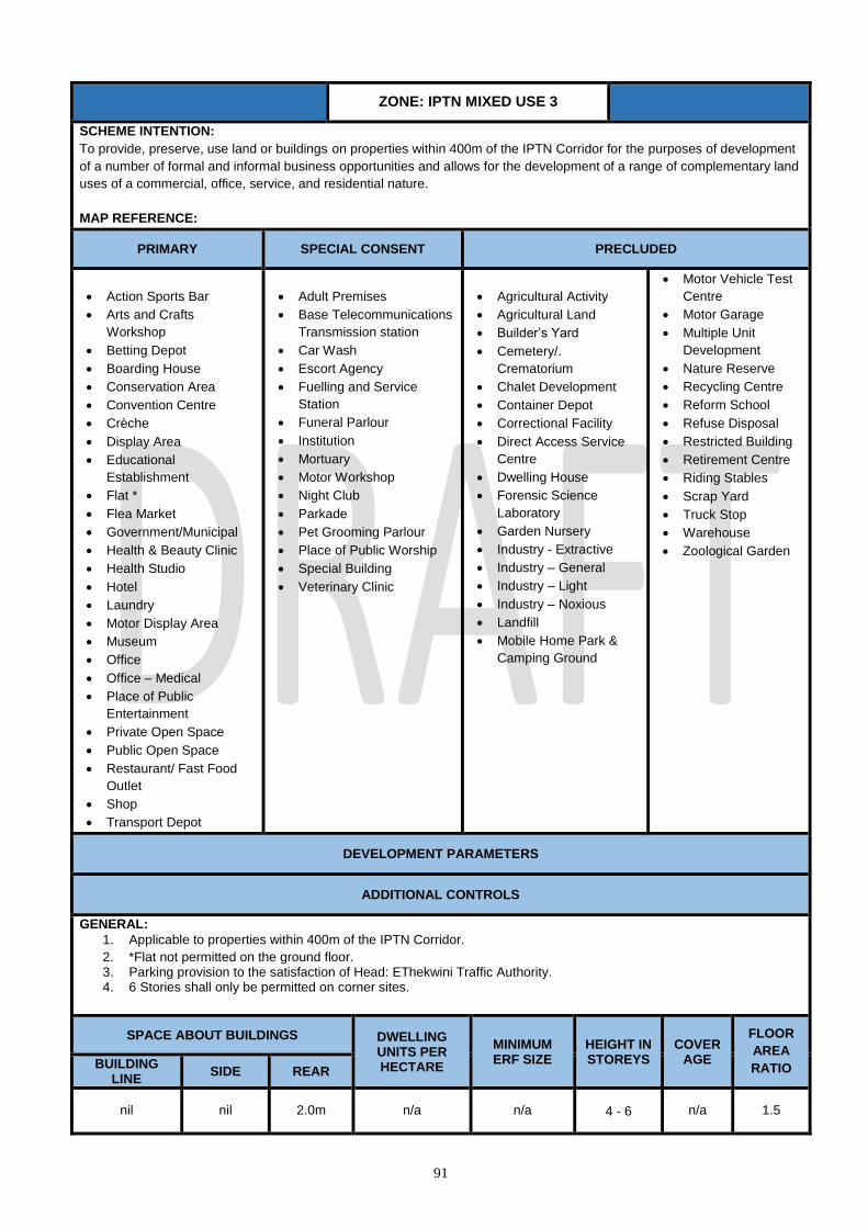
91
ZONE: IPTN MIXED USE 3
SCHEME INTENTION:
To provide, preserve, use land or buildings on properties within 400m of the IPTN Corridor for the purposes of development
of a number of formal and informal business opportunities and allows for the development of a range of complementary land
uses of a commercial, office, service, and residential nature.
MAP REFERENCE:
PRIMARY SPECIAL CONSENT PRECLUDED
Action Sports Bar
Arts and Crafts
Workshop
Betting Depot
Boarding House
Conservation Area
Convention Centre
Crèche
Display Area
Educational
Establishment
Flat *
Flea Market
Government/Municipal
Health & Beauty Clinic
Health Studio
Hotel
Laundry
Motor Display Area
Museum
Office
Office – Medical
Place of Public
Entertainment
Private Open Space
Public Open Space
Restaurant/ Fast Food
Outlet
Shop
Transport Depot
Adult Premises
Base Telecommunications
Transmission station
Car Wash
Escort Agency
Fuelling and Service
Station
Funeral Parlour
Institution
Mortuary
Motor Workshop
Night Club
Parkade
Pet Grooming Parlour
Place of Public Worship
Special Building
Veterinary Clinic
Agricultural Activity
Agricultural Land
Builder’s Yard
Cemetery/.
Crematorium
Chalet Development
Container Depot
Correctional Facility
Direct Access Service
Centre
Dwelling House
Forensic Science
Laboratory
Garden Nursery
Industry - Extractive
Industry – General
Industry – Light
Industry – Noxious
Landfill
Mobile Home Park &
Camping Ground
Motor Vehicle Test
Centre
Motor Garage
Multiple Unit
Development
Nature Reserve
Recycling Centre
Reform School
Refuse Disposal
Restricted Building
Retirement Centre
Riding Stables
Scrap Yard
Truck Stop
Warehouse
Zoological Garden
DEVELOPMENT PARAMETERS
ADDITIONAL CONTROLS
GENERAL:
1. Applicable to properties within 400m of the IPTN Corridor.
2. *Flat not permitted on the ground floor. 3. Parking provision to the satisfaction of Head: EThekwini Traffic Authority. 4. 6 Stories shall only be permitted on corner sites.
SPACE ABOUT BUILDINGS DWELLING UNITS PER HECTARE
MINIMUM ERF SIZE
HEIGHT IN STOREYS
COVERAGE
FLOOR
AREA
RATIO BUILDING LINE
SIDE REAR
nil nil 2.0m n/a n/a 4 - 6 n/a 1.5

92
ZONE: IPTN RESIDENTIAL
SCHEME INTENTION: To provide, preserve, use land or buildings for:
• Higher density on all types of residential accommodation.
• A wide range of ancillary uses which service the day to day needs of a residential community.
MAP REFERENCE:
PRIMARY SPECIAL CONSENT PRECLUDED
Dwelling House
Conservation Area
Flat
Hotel
Multiple Unit Development
Private Open Space
Public Open Space
Retirement Centre
Base Telecommunications
Transmission station
Boarding House
Chalet Development
Crèche
Educational Establishment
Health Studio
Health & Beauty Clinic
Laundry
Institution
Mobile Home Park & Camping
Ground
Office – Medical
Place of Public Worship
Restaurant/ Fast Food Outlet*
Shop*
Special Building
Veterinary Clinic
Action Sports Bar
Adult Premises
Agricultural Activity
Agricultural Land
Arts and Crafts
Workshop
Betting Depot
Builder’s Yard
Car Wash
Cemetery/ Crematorium
Container Depot
Convention Centre
Correctional Facility
Direct Access Service
Centre Display Area
Escort Agency
Flea Market
Forensic Science
Laboratory
Fuelling and Service
Station
Funeral Parlour
Garden Nursery
Government/Municipal
Industry: Extractive
Industry: General
Industry: Light
Industry: Noxious
Landfill
Mortuary
Motor Display Area
Motor Garage
Motor Vehicle Test
Centre
Motor Workshop
Museum
Nature Reserve
Night Club
Office
Parkade
Pet Grooming
Parlour
Place of Public
Entertainment
Recycling Centre
Reform School
Refuse Disposal
Restricted Building
Riding Stables
Scrap Yard
Transport Depot
Truck Stop
Warehouse
Zoological Garden
ADDITIONAL CONTROLS
GENERAL:
1. Applicable to properties within 400m of the IPTN Corridor.
2. Parking provision to the satisfaction of Head: EThekwini Traffic Authority.
3. *Shop restricted to ground floor only.
4. *Restaurant/Fast-food Outlet restricted to ground floor only.
SPACE ABOUT BUILDINGS DWELLING UNITS PER HECTARE
MINIMUM ERF SIZE
HEIGHT IN
STOREYS
COVERAGE
FLOOR
AREA
RATIO BUILDING LINE SIDE REAR
nil nil 5m n/a n/a 4 60% 2

93
ZONE: IPTN TRANSPORT DEPOT
SCHEME INTENTION: To provide, preserve, use land or buildings for:
The provision of land used for the purpose of parking buses and taxis and/or as a transport depot and associated parking for
the use of transportation and ancillary uses ordinarily associated thereto.
MAP REFERENCE:
PRIMARY SPECIAL CONSENT PRECLUDED
Transport Depot
Action Sports Bar
Betting Depot
Base Telecommunications
Transmission Station
Special Building
Health & Beauty Clinic
Health Studio
Office
Office – Medical
Restaurant/ Fast Food Outlet
Shop
Adult Premises
Agricultural Activity
Agricultural Land
Arts and Crafts Workshop
Boarding House
Builder’s Yard
Car Wash
Cemetery/ Crematorium
Chalet Development
Container Depot
Conservation Area
Convention Centre
Correctional Facility
Crèche
Direct Access Service Centre
Display Area
Dwelling House
Educational Establishment
Escort Agency
Flat
Flea Market
Funeral Parlour
Fuelling and Service Station
Garden Nursery
Government/Municipal
Hotel
Industry - Extractive
Industry – General
Industry – Light
Industry – Noxious
Institution
Landfill
Laundry
Mobile Home Park &
Camping
Ground
Mortuary
Motor Display Area
Motor Garage
Motor Vehicle Test Centre
Multiple Unit Development
Museum
Motor Workshop
Nature Reserve
Night Club
Parkade
Pet Grooming Parlour
Place of Public
Entertainment
Private Open Space
Public Open Space
Recycling Centre
Reform School
Refuse Disposal
Restricted Building
Retirement Centre
Riding Stables
Scrap Yard
Truck Stop
Veterinary Clinic
Warehouse
Zoological Garden
ADDITIONAL CONTROLS
GENERAL:
1. A mandatory minimum buffer of 30m and a maximum of 40m is required along the road frontage to facilitate a
desirable building interface to the depot.
2. Applicable to properties within 400m of the IPTN Corridor.
3. Parking provision to the satisfaction of Head: EThekwini Traffic Authority.
DEVELOPMENT PARAMETERS
SPACE ABOUT BUILDINGS DWELLING
UNITS PER
HECTARE
MINIMUM
ERF SIZE
HEIGHT IN
STOREYS
COVER
AGE
FLOOR
AREA
RATIO BUILDING
LINE SIDES REAR
As above 3m 3m n/a n/a 4 80% 1.0

94
ZONE: TRANSPORT ORIENTED
DEVELOPMENT
(Applicable to the C3 (Corridor) Land Use Strategy)
SCHEME INTENSION: A zone that make provision for the parking, drop off and collection of passengers by rail, public and
private bus services and mini bus taxis, as well as associated commercial and residential land uses. MAP REFERENCE:
PRIMARY SPECIAL CONSENT PRECLUDED
Action Sports Bar
Betting Depot
Car Wash
Display Area
Educational Establishment
Flat
Fuelling and Service Station
Government/Municipal
Laundry
Office
Office – Medical
Parkade
Restaurant/ Fast Food Outlet
Shop
Transport Depot
Adult Premises
Base Telecommunications
Transmission station
Institution
Health & Beauty Clinic
Health Studio
Hotel
Pet Grooming Parlour
Place of Public Worship
Place of Public
Entertainment
Special Building
Veterinary Clinic
Agricultural
Activity
Agricultural Land
Arts and Crafts
Workshop
Boarding House
Builder’s Yard
Cemetery/.
Crematorium
Chalet
Development
Dwelling House
Conservation
Area
Convention
Centre
Crèche
Container Depot
Correctional
Facility
Direct Access
Service Centre
Escort Agency
Funeral Parlour
Forensic Science
Laboratory
Flea Market
Garden Nursery
Industry -
Extractive
Industry –
General
Industry – Light
Industry –
Noxious
Landfill
Mobile Home
Park &
Camping
Ground
Motor Garage
Motor Display
Area
Motor
Workshop
Museum
Mortuary
Motor Vehicle
Test Centre
Multiple Unit
Development
Night Club
Nature Reserve
Recycling
Centre
Reform School
Refuse
Disposal
Restricted
Building
Retirement
Centre
Riding Stables
Private Open
Space
Public Open
Space
Scrap Yard
Truck Stop
Zoological Garden
Warehouse
DEVELOPMENT PARAMETERS
SPACE ABOUT BUILDINGS DWELLING UNITS PER HECTARE
MINIMUM ERF SIZE
HEIGHT IN STOREYS
COVERAGE
FLOOR
AREA
RATIO BUILDING
LINE SIDES REAR
nil nil nil n/a n/a 6 90% 2.5

95
ZONE: LIGHT INDUSTRY
SCHEME INTENTION: To provide, preserve, use land or buildings for:-
Low impact mix of industrial activities and services and may be an interface to high impact industrial areas or as independent entities.
Commercial activities such as factory shop, wholesale and shops are permitted at the discretion of the Municipality.
Extractive and noxious industrial activities are prohibited.
MAP COLOUR REFERENCE: Purple MAP REFERENCE:
PRIMARY SPECIAL CONSENT PRECLUDED
Arts and Crafts Workshop
Builder’s Yard
Car Wash
Container Depot
Display Area
*Dwelling House
Funeral Parlour
Garden Nursery
Government/Municipal
Industry - Light Laundry
Market
Motor Display Area
Motor Vehicle Test Centre
Motor Workshop
Recycling Centre
Veterinary Clinic
Warehouse
Action Sports Bar
Adult Premises
Agricultural Activity
Airport
Base Telecommunications Transmission station
Betting Depot
Cemetery
Crematorium
Conference Facility
Educational Establishment
Fuelling and Service Station
Health Studio
Industry - General
Institution
Landfill
Mortuary
Motor Garage
*Office
*Office – Medical
Night Club
Parkade
Pet Grooming Parlour
Place of Public Entertainment
Place of Public Worship
Refuse Disposal
Restaurant / Fast Food Outlet
Shop
Transport Depot
Truck Stop
Special Building
Utilities Facility
Any other use authorized in terms of Section 9.4
All other uses not indicated in the
Primary and Special Consent columns
ADDITIONAL CONTROLS
1. *A Dwelling House may be permitted to accommodate a manager, foreman, caretaker or security personnel.
2. *Offices and *Office-Medical used in conjunction with an industrial use shall be freely permitted.
3. 7.5m when opposite Residential and Public Open Space sites.
4. In respect of remainder of Portion 44 of Erf 1320 Durban, a Place of Public Entertainment relating to a Performing Art Centre, may be permitted with
the Special Consent of the Municipality.
5. In addition to the provisions of this zone, and in respect of and Erf 43 Avoca, Erf 44 Avoca, Erf 45 Avoca and Remainder of 3364 Durban North
situated in Prince Mhlangana Road, the following shall apply:
i) trucking and transport uses are prohibited;
ii) Light industrial uses with no impact shall be permitted;
iii) Any building on the site shall observe a 10 metre building line and 5 metre side spaces
iv) Any building on the site shall not exceed a height of 2 storeys and;
v) Any building on the site shall not exceed coverage 60%.
vi) In the case of Erf 43 Avoca, Erf 44 Avoca and Erf 45 Avoca situated in Prince Mhlangana Road, a 32 metres wide conservation servitude shall
be registered across the properties from the centre line of the stream.
DEVELOPMENT PARAMETERS
SPACE ABOUT BUILDINGS DWELLING UNITS
PER HECTARE
MINIMUM SUBDIVISION(
m2) HEIGHT COVERAGE
FLOOR AREA RATIO
BUILDING LINE SIDE AND
REAR SPACE N/A 900 25 metres N/A N/A
Nil and 7.5m see N/A
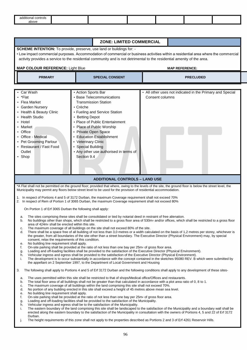
96
additional controls above
ZONE: LIMITED COMMERCIAL
SCHEME INTENTION: To provide, preserve, use land or buildings for: -
• Low impact commercial purposes. Accommodation of commercial or business activities within a residential area where the commercial
activity provides a service to the residential community and is not detrimental to the residential amenity of the area.
MAP COLOUR REFERENCE: Light Blue MAP REFERENCE:
PRIMARY SPECIAL CONSENT PRECLUDED
• Car Wash
• *Flat
• Flea Market
• Garden Nursery
• Health & Beauty Clinic
• Health Studio
• Hotel
• Market
• Office
• Office - Medical
• Pet Grooming Parlour
• Restaurant / Fast Food
Outlet
• Shop
• Action Sports Bar
• Base Telecommunications
Transmission Station
• Crèche
• Fueling and Service Station
• Betting Depot
• Place of Public Entertainment
• Place of Public Worship
• Private Open Space
• Education Establishment
• Veterinary Clinic
• Special Building
• Any other use authorised in terms of
Section 9.4
• All other uses not indicated in the Primary and Special
Consent columns
ADDITIONAL CONTROLS – LAND USE
*A Flat shall not be permitted on the ground floor; provided that where, owing to the levels of the site, the ground floor is below the street level, the Municipality may permit any floors below street level to be used for the provision of residential accommodation. 1. In respect of Portions 4 and 5 of 3172 Durban, the maximum Coverage requirement shall not exceed 70% 2. In respect of Rem of Portion 1 of 3065 Durban, the maximum Coverage requirement shall not exceed 80%
On Portion 1 of Erf 3065 Durban the following shall apply:
a. The sites comprising these sites shall be consolidated or tied by notarial deed in restraint of free alienation. b. No buildings other than shops, which shall be restricted to a gross floor area of 530m5 and/or offices, which shall be restricted to a gross floor
area of 424m5 shall be erected within this site. c. The maximum coverage of all buildings on the site shall not exceed 80% of the site. d. There shall be a space free of all building of not less than 3,0 metres or a width calculated on the basis of 1,2 metres per storey, whichever is
the greater, from all boundaries of the site other than a street boundary. The Executive Director (Physical Environment) may, by special consent, relax the requirements of this condition.
e. No building line requirement shall apply. f. On-site parking shall be provided at the ratio of not less than one bay per 25m5 of gross floor area. g. Loading and off-loading facilities shall be provided to the satisfaction of the Executive Director (Physical Environment). h. Vehicular ingress and egress shall be provided to the satisfaction of the Executive Director (Physical Environment). i. The development is to occur substantially in accordance with the concept contained in the sketches 95080 REV. B which were submitted by
the appellant on 2 September 1997, to the Department of Local Government and Housing 3. The following shall apply to Portions 4 and 5 of Erf 3172 Durban and the following conditions shall apply to any development of these sites-
a. The uses permitted within this site shall be restricted to that of shops/Medical office/Offices and restaurants. b. The total floor area of all buildings shall not be greater than that calculated in accordance with a plot area ratio of 0, 8 to 1. c. The maximum coverage of all buildings within the land comprising this site shall not exceed 70%. d. No portion of any building erected in this site shall exceed a height of 45 metres above mean sea level. e. No building line requirement shall apply. f. On-site parking shall be provided at the ratio of not less than one bay per 25m5 of gross floor area. g. Loading and off-loading facilities shall be provided to the satisfaction of the Municipality. h. Vehicular ingress and egress shall be to the satisfaction of the Municipality. i. The eastern boundary of the land comprising this site shall be landscaped to the satisfaction of the Municipality and a boundary wall shall be
erected along the eastern boundary to the satisfaction of the Municipality in consultation with the owners of Portions 4, 5 and 22 of Erf 3172 Durban.
j. The height requirements of this zone shall not apply to the properties described as Portions 2 and 3 of Erf 4261 Reservoir Hills.

97
4. Notwithstanding any other provisions of this scheme, the development of the Special Shopping (Limited Commercial) Zone situated at Wood Road,
Henley Road and Roland Chapman Drive shall adhere to the following :-
- The properties described as Rem. of Portion of Erf 844, Rem. of Portion 3 of Erf 844, Portion 4 (of 2) of Erf 844 and Portion 1 of Erf 844 all of
Sea View, be consolidated.
- Loading and unloading of delivery vehicles shall take place within a demarcated area and there shall be no stacking, parking or
loading/unloading of delivery vehicles on Henley Road.
- The signalisation of the intersection of Wood and Henley Roads, if required at some future date, shall be to the developers cost.
5. The development of Portion 3 of erf 113 Springfield situated at 1/3 Alpine Road is subject to a limitation on the coverage on the site, which may not
exceed 30%.
DEVELOPMENT PARAMETERS
SPACE ABOUT BUILDINGS
DWELLING UNITS PER HECTARE
MINIMUM
SUBDIVISION(m2
)
HEIGHT COVERAGE FLOOR
AREA RATIO BUILDING LINE
SIDE AND REAR SPACE
3.0m Nil N/A 450 2 50% N/A
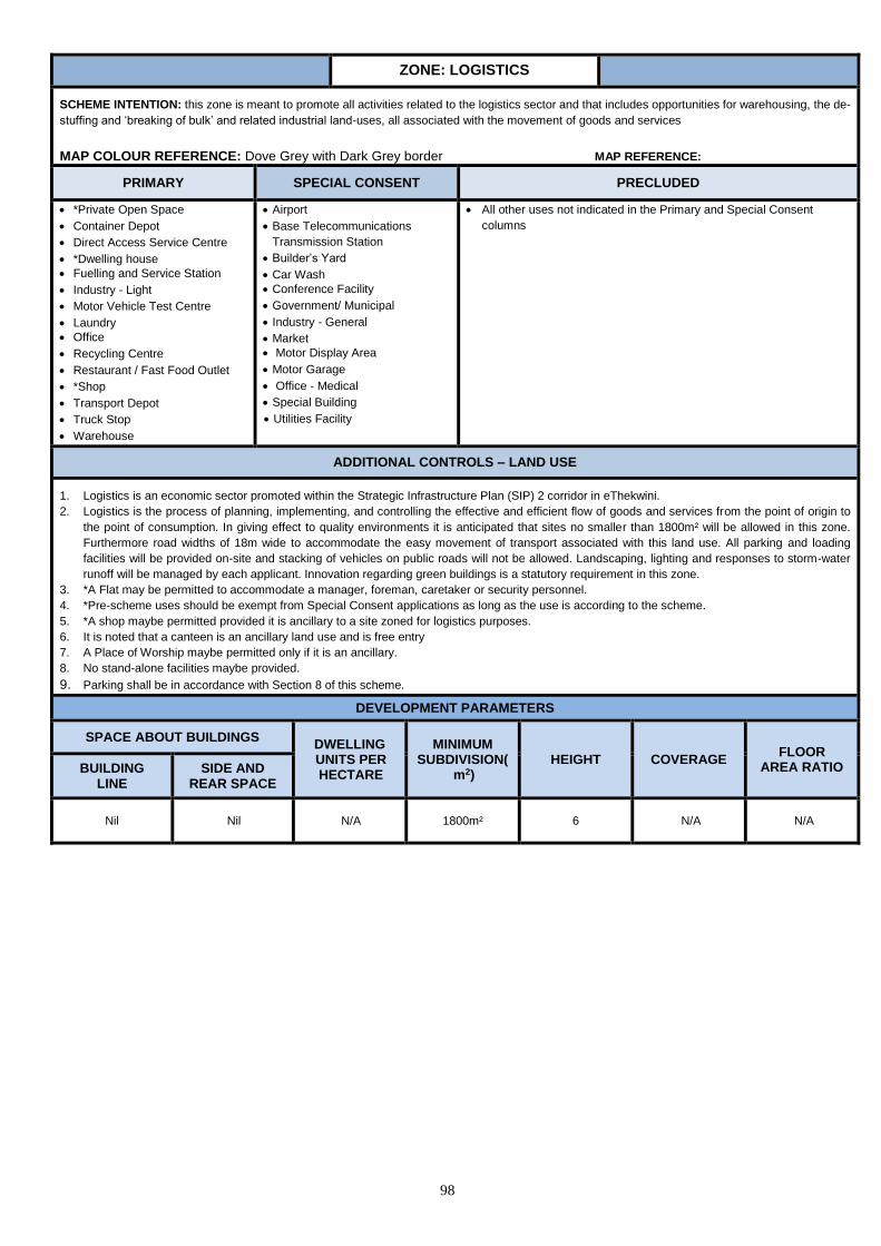
98
ZONE: LOGISTICS
SCHEME INTENTION: this zone is meant to promote all activities related to the logistics sector and that includes opportunities for warehousing, the de-
stuffing and ‘breaking of bulk’ and related industrial land-uses, all associated with the movement of goods and services
MAP COLOUR REFERENCE: Dove Grey with Dark Grey border MAP REFERENCE:
PRIMARY SPECIAL CONSENT PRECLUDED
*Private Open Space
Container Depot
Direct Access Service Centre
*Dwelling house
Fuelling and Service Station
Industry - Light
Motor Vehicle Test Centre
Laundry
Office
Recycling Centre
Restaurant / Fast Food Outlet
*Shop
Transport Depot
Truck Stop
Warehouse
Airport
Base Telecommunications
Transmission Station
Builder’s Yard
Car Wash
Conference Facility
Government/ Municipal
Industry - General
Market
Motor Display Area
Motor Garage
Office - Medical
Special Building
Utilities Facility
All other uses not indicated in the Primary and Special Consent
columns
ADDITIONAL CONTROLS – LAND USE
1. Logistics is an economic sector promoted within the Strategic Infrastructure Plan (SIP) 2 corridor in eThekwini.
2. Logistics is the process of planning, implementing, and controlling the effective and efficient flow of goods and services from the point of origin to
the point of consumption. In giving effect to quality environments it is anticipated that sites no smaller than 1800m² will be allowed in this zone.
Furthermore road widths of 18m wide to accommodate the easy movement of transport associated with this land use. All parking and loading
facilities will be provided on-site and stacking of vehicles on public roads will not be allowed. Landscaping, lighting and responses to storm-water
runoff will be managed by each applicant. Innovation regarding green buildings is a statutory requirement in this zone.
3. *A Flat may be permitted to accommodate a manager, foreman, caretaker or security personnel.
4. *Pre-scheme uses should be exempt from Special Consent applications as long as the use is according to the scheme.
5. *A shop maybe permitted provided it is ancillary to a site zoned for logistics purposes.
6. It is noted that a canteen is an ancillary land use and is free entry
7. A Place of Worship maybe permitted only if it is an ancillary.
8. No stand-alone facilities maybe provided.
9. Parking shall be in accordance with Section 8 of this scheme.
DEVELOPMENT PARAMETERS
SPACE ABOUT BUILDINGS DWELLING UNITS PER HECTARE
MINIMUM SUBDIVISION(
m2) HEIGHT COVERAGE
FLOOR AREA RATIO BUILDING
LINE SIDE AND
REAR SPACE
Nil
Nil N/A 1800m² 6 N/A N/A

99
ZONE: MIXED USE 1
SCHEME INTENTION: To provide, preserve, use land or buildings for:-
• Residential and Commercial activities that compliment or function alongside of each other. Mixed uses areas which would accommodate residential, office and commercial activities.
• Development appropriate to residential areas particularly Special Residential, Intermediate Residential and General Residential zone areas
MAP REFERENCE: Blue border with Yellow background and blue Cross Hatch MAP REFERENCE:
PRIMARY SPECIAL CONSENT PRECLUDED
• Arts and Crafts Workshop
• Boarding House
• Conference Facility
• Display Area
• Dwelling House
• *Flat
• Flea Market
• Garden Nursery
• Health & Beauty Clinic
• Health Studio
• Hotel
• Museum
• Offices
• Office - Medical
• Pet Grooming Parlour
• Restaurant/ Fast Food Outlet
• Shop
• Action Sports Bar
• Base Telecommunications
Transmission Station
• Betting Depot
• Car Wash
• Crèche
• Educational Establishment
• Fuelling and Service Station
• Government / Municipal
• Institution
• Market
• Motor Display Area
• Parkade
• Place of Public Entertainment
• Place of Public Worship
• Special Building
• Any other use authorised in
terms of Section 9.4
• All other uses not indicated in the Primary and Special Consent columns
ADDITIONAL CONTROLS – LAND USE
1. *Flats are not permitted on the ground floor.
2. Parking shall be in accordance with Section 8 of this Scheme.
In the case of Felix Dlamini Activity Precinct Zone :
1. Details of Primary, Special Consent and Precluded uses are in terms of the Precinct Plans for this zone.
2. Any uses authorized in terms of sub-section 9.4 shall be with the Special Consent of the Municipality.
3. Note: All erven as indicated on the precinct plans approved by the Municipality shall, on application to the Municipality be zoned in accordance
with this zone read in conjunction with the precinct plans.
In the case of Portion 25 of Erf 351 Brickfield the following shall apply:-
• The open portion of the site shall be suitably landscaped to the satisfaction of the Municipality.
• *Offices - portion of the site shall be suitably landscaped at the discretion of the Municipality. • *Flat – is restricted to a maximum floor area of 70% and such use shall not be permitted on ground floor. • *A Dwelling House may be permitted to accommodate a manager, caretaker or security personnel. • Open portion of the site shall be suitably landscaped to the satisfaction of the Municipality.
• Private garages detached from the main building or Carports may be erected closer to the side boundary than herein specified.
Details of development parameters are in terms of the precinct plans for this zone. 1. In the case of Portion 25 of Erf 351 Brickfield the following shall apply; Building Line: 7.5m Side and Rear Space: Residential and Office uses = 4.5m Dwelling units per hectare: N/A Minimum Erf size: 900m² Height: 5 storeys Coverage: 45% Floor Area Ratio: 1.7.
DEVELOPMENT PARAMETERS
SPACE ABOUT BUILDINGS DWELLING UNITS PER
HECTARE MINIMUM
SUBDIVISION (m2) HEIGHT
COVERAGE (%)
FLOOR AREA RATIO
BUILDING LINE SIDE AND
REAR SPACE
3.0m 3.0m Net site area divided 90. The figure reached rounded off to the nearest
whole 400 N/A 50 1.0 2
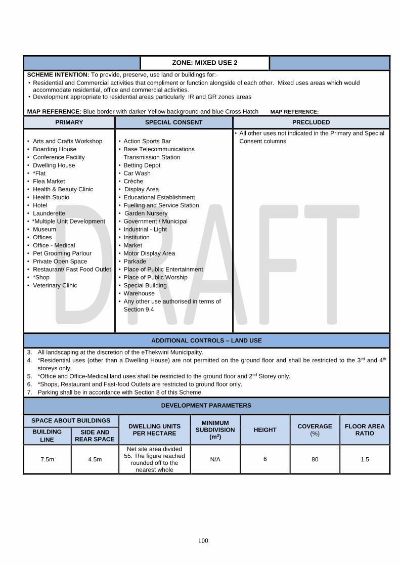
100
ZONE: MIXED USE 2
SCHEME INTENTION: To provide, preserve, use land or buildings for:-
• Residential and Commercial activities that compliment or function alongside of each other. Mixed uses areas which would accommodate residential, office and commercial activities.
• Development appropriate to residential areas particularly IR and GR zones areas
MAP REFERENCE: Blue border with darker Yellow background and blue Cross Hatch MAP REFERENCE:
PRIMARY SPECIAL CONSENT PRECLUDED
• Arts and Crafts Workshop
• Boarding House
• Conference Facility
• Dwelling House
• *Flat
• Flea Market
• Health & Beauty Clinic
• Health Studio
• Hotel
• Launderette
• *Multiple Unit Development
• Museum
• Offices
• Office - Medical
• Pet Grooming Parlour
• Private Open Space
• Restaurant/ Fast Food Outlet
• *Shop
• Veterinary Clinic
• Action Sports Bar
• Base Telecommunications
Transmission Station
• Betting Depot
• Car Wash
• Crèche
• Display Area
• Educational Establishment
• Fuelling and Service Station
• Garden Nursery
• Government / Municipal
• Industrial - Light
• Institution
• Market
• Motor Display Area
• Parkade
• Place of Public Entertainment
• Place of Public Worship
• Special Building
• Warehouse
• Any other use authorised in terms of
Section 9.4
• All other uses not indicated in the Primary and Special
Consent columns
ADDITIONAL CONTROLS – LAND USE
3. All landscaping at the discretion of the eThekwini Municipality.
4. *Residential uses (other than a Dwelling House) are not permitted on the ground floor and shall be restricted to the 3 rd and 4th
storeys only.
5. *Office and Office-Medical land uses shall be restricted to the ground floor and 2nd Storey only.
6. *Shops, Restaurant and Fast-food Outlets are restricted to ground floor only.
7. Parking shall be in accordance with Section 8 of this Scheme.
DEVELOPMENT PARAMETERS
SPACE ABOUT BUILDINGS DWELLING UNITS
PER HECTARE
MINIMUM SUBDIVISION
(m2) HEIGHT
COVERAGE
(%)
FLOOR AREA RATIO BUILDING
LINE
SIDE AND REAR SPACE
7.5m 4.5m
Net site area divided 55. The figure reached
rounded off to the nearest whole
N/A 6 80 1.5

101
ZONE: MEDIUM DENSITY HOUSING
SCHEME INTENTION: To provide, preserve, use land or buildings for Multiple unit developments. It is intended to promote the development of
attached and detached dwelling units as part of a larger planned residential development.
MAP COLOUR REFERENCE: Brown border with Orange background MAP REFERENCE:
PRIMARY SPECIAL CONSENT PRECLUDED
Dwelling house
Multiple Unit Development
Base Telecommunications Transmission
Station
• Crèche
Chalet Development
• Educational Establishment
*Institution
Mobile Home Park & Camping Ground
Place of Public Worship
Special Building
Any other use authorised in terms of
Section 9.4
All other uses not indicated in the Primary and Special
Consent columns
ADDITIONAL CONTROLS – LAND USE
1. Not less than 20% of the site shall be set aside and maintained for garden and recreation purposes, which must be kept free of buildings, parking
spaces and driveways, to the satisfaction of the Head: Development Planning, Environment and Management.
2. The siting, size, design and layout shall be to the satisfaction of the Head: Development Planning, Environment and Management.
3. The following controls shall apply to the property described as Erf 250 Bluff and the following conditions shall apply to any development of the land
comprising this Site:
The purpose for which land may be used or for which buildings may be erected and used: - dwelling house, ancillary unit and flat.
The maximum number of dwelling units permitted within this site shall be 15 and all buildings shall be positioned within the development area as depicted on Plan No.1039/01 dated 2002-02-15. (See Appendix 1.2)
An Environmental Management Plan shall be submitted to the Executive Director (Development & Planning) for approval prior to the development of the land comprising this site.
The building line to Netford Road shall not be less than 7,5 metres, provided this requirement may be relaxed with the special consent of the Municipality; provided further than an entrance gatehouse and refuse bin may be erected in advance of the 7,5 metre building line at the discretion of the Executive Director (Development & Planning).
No building shall be erected within 3,0 metres of the side and rear boundaries of the land comprising this site, provided that the side spaces shall be measured from the boundary of the property and shall disregard the 7,62 metre and 6,10 metre road servitudes on the south western and north-eastern boundaries respectively.
The maximum coverage for all buildings shall not exceed 40% of the development area as depicted on Plan No.1039/01 dated 2002-02-15.
No building within this site shall exceed 2 storeys in height.
On site parking shall be provided at not less than one parking bay for each dwelling unit and additional parking shall be provided for visitors at a ratio of one parking bay for every 3 dwelling units or part thereof.
Vehicular and pedestrian ingress and egress shall be to the satisfaction of the Executive Director (Development & Planning).
Stormwater drainage and sewage disposal shall be to the satisfaction of the Executive Director (Development & Planning).
4. The following controls shall apply to the property described as Erf 206 Starwood and the following conditions shall apply to the development of this Site.
Development of the land comprising this site shall comply with the provisions applicable to a General Residential 1 Zone provided that :-
Buildings erected within this Zone shall not be used for any purposes other than residential dwelling units and shall be restricted to a maximum of 12 units.
On-site parking shall be restricted to 12 bays at a rate of one parking bay per dwelling unit.
No vehicular access to the land comprising this site shall be taken off Phoenix Highway.
The Municipality may authorise on a sloping site the erection of a building 3 storeys in height, provided that such building has at no point more than two storeys in a vertical line.
*Institution: The minimum Erf size for an Institution shall be 900m2.
The Municipality may by Special Consent authorise on a sloping site the erection of a building which is more than 3 storeys in height if such building will at no point have more than 2 storeys in a vertical line or the erection of a building which is 3 storeys in height; provided that the Municipality may exempt an applicant from applying for Special Consent; provided further, that the prior written consent of the

102
registered owner of each adjoining property and such other properties as the Municipality may direct, has first been obtained.
Building lines, side and rear spaces for swimming pools shall be 1.0m; provided that such pool is screened to the satisfaction of the Municipality.
Private garages detached from the main building or Carports may be erected closer to the side boundary than herein specified.
5. The following additional uses may be permitted on Portion 4 and Rem. of Erf 229 Umgeni Park:
dwelling house, residential building, frail care facility, medical consulting rooms, offices, restaurant, shop, recreational facilities; provided that the medical consulting rooms, offices, restaurant, shop, recreational facilities are, in the opinion of the Municipality, ancillary to the primary use of the entire property for residential purposes, except in respect of Portion 4 of Erf 229 Umgeni Park on which land may be used or buildings may be erected and used for Frail Care Facility and Residential Buildings only
in addition, the following conditions shall apply:
The siting, size, design and layout of any of the medical consulting rooms, offices, restaurant, shop, and recreational facilities shall be to the satisfaction of the Head: Development Planning, environment and management
No subdivision shall have an area less than 240m2.
The maximum number of dwelling units shall be 224 (inclusive of the units within the Frail Care Centre).
The building line to Anthony and Hillbrow Roads shall be 7.5m.
An entrance gatehouse and refuse bin area may be erected in advance of the 7.5m building line at the discretion of the Municipality.
No building within the site shall exceed two storeys in height above ground level, except in respect of Portion 4 of Erf 229 Umgeni Park whereon no building shall exceed a height of 82 metres above mean sea level.
On-site parking shall be provided as follows:-
(a) in the case of residential development not less than one parking bay shall be provided for each dwelling unit and additional parking shall be provided for visitors at the ratio of one parking bay for every three dwelling units or part thereof; and
(b) in the case of the frail care facility and non-residential development not less than one parking bay for every 30m² of gross floor area of such frail care facility and non-residential development;
provided that the Municipality may at her discretion vary any of the requirements contained in (a) and (b) above.
DEVELOPMENT PARAMETERS
SPACE ABOUT BUILDINGS DWELLING UNITS PER
HECTARE
MINIMUM
SUBDIVISIO
N(m2)
HEIGHT COVERAGE
FLOOR AREA
RATIO
BUILDING
LINE SIDE REAR
5.0m 3.0m
3.0m
One dwelling unit for every
100m2 of net site area with
the resultant quotient being
taken to the nearest unit or
if there is a fraction of one
half, the next highest.
650m2 2 50% N/A

103
ZONE: NOXIOUS INDUSTRY
SCHEME INTENTION: To provide, use land or buildings for a full range of heavy and high impact industrial activities that produce fumes, gases, vapours,
dust, smell, noise, vibration or other causes and excludes any Extractive Industry that is deemed dangerous to the general public by the eThekwini
Municipality.
MAP COLOUR REFERENCE: Purple with dark Purple cross hatch MAP REFERENCE:
PRIMARY SPECIAL CONSENT PRECLUDED
• Agricultural Activity
• Builder’s Yard
• Container Depot
• Direct Access Service Centre
• Display Area
• *Dwelling House
• Fuelling and Service Station
• Government / Municipal
• Industry – General
• Industry – Light
• Industry – Noxious
• Laundry
• Mortuary
• Museum
• Motor Display Area
• Motor Garage
• Motor Vehicle Test Centre
• Motor Workshop
• Recycling Centre
• Scrap Yard
• Transport Depot
• Truck Stop
• Utilities Facility
• Warehouse
• Action Sports Bar
• Adult Premises
• Base Telecommunications Transmission
Station
• Betting Depot
• Car Wash
• Cemetery/Crematorium
• Funeral Parlour
• Health Studio
• Institution
• Landfill
• Night Club
• *Office
• *Office - Medical
• Parkade
• Pet Grooming Parlour
• Place of Public Entertainment
• Place of Public of Worship
• Refuse Disposal
• *Shop
• Special Building
• Veterinary Clinic
• Educational Establishment
• Harbour Amenity Facility
• Restaurant / Fast Food Outlet
• Any use authorized in terms of Section 9.4
• All other uses not indicated in the Primary
and Special Consent columns
ADDITIONAL CONTROLS – LAND USE
1. *A Dwelling House may be permitted to accommodate a manager, foreman, caretaker or security personnel.
2. *Offices and *Office-Medical used in conjunction with an industrial use shall be freely permitted.
3. 7.5m when opposite Residential and Public Open Space sites.
Education facility shall be related to the intent of the zone
Notwithstanding the provisions of height below, the Head: Development Planning and Management may authorise the erection of a building of a greater
height if it is satisfied that such greater height will not result in detriment to the amenities of the area and:-
i) Such greater height is necessary having regard to the particular industrial processes which it is proposed to carry out on the site; or
ii) Such greater height is reasonable having regard to the topography of the site;
DEVELOPMENT PARAMETERS
SPACE ABOUT BUILDINGS DWELLING UNITS PER HECTARE
MINIMUM ERFSIZE (m2)
HEIGHT COVERAGE FLOOR
AREA RATIO BUILDING LINE
SIDE AND REAR SPACE
Nil and 7.5m Nil N/A 1800 25 metres N/A N/A

104
ZONE: OFFICE
SCHEME INTENTION: To provide, use land or buildings for development of offices
MAP COLOUR REFERENCE: White with Blue cross hatch MAP REFERENCE:
PRIMARY SPECIAL CONSENT PRECLUDED
• Office
• Office - Medical
• *Restaurant / Fast Food
Outlet
• Base Telecommunications
Transmission station
• Boarding House
• Conference Facility
• *Crèche
• Hotel
• Institution
• Special Building
• All other uses not indicated in the Primary and Special Consent
columns
ADDITIONAL CONTROLS – LAND USE
1. 20% of the site shall be suitably landscaped to the satisfaction of the Municipality.
2. The Municipality may by Special Consent authorise a crèche for the use of the registered workers of a company.
3. *A dwelling unit limited to 100m2 may be provided to accommodate a manager, caretaker or security personnel.
4. Such dwelling unit in 3 above, shall not be permitted in the ground floor.
5. * Restaurant/ Fast Food Outlet that is ancillary to an office block may be permitted at the discretion of the Municipality.
6. Parking shall be in accordance with Section 8. of this scheme.
7. On Remainder of Portion 10 of Erf 40 Durban North the following shall apply:
No portion of any building erected in this site shall exceed a height of 47,8 metres above mean sea level;
The building lines shall not be less than 4,0 metres to Thames Place; and
No building shall be erected within 3,0 metres of the southern boundary of the site;
DEVELOPMENT PARAMETERS
SPACE ABOUT BUILDINGS DWELLING UNITS PER HECTARE
MINIMUM SUBDIVISION
(m2) HEIGHT COVERAGE
FLOOR AREA RATIO BUILDING
LINE SIDE AND SPACE
REAR SPACE
7.5m 3m N/A 900 2 storeys 40% 0.8

105
ZONE: PRIVATE OPEN SPACE
SCHEME INTENTION: To provide, preserve, use land or buildings for: -
Provision of active and passive recreational areas on privately owned land.
Generally to promote private recreation, enhance aesthetical appearance and promote the maintenance of functional open space
systems.
MAP COLOUR REFERENCE: Light Green MAP REFERENCE:
PRIMARY SPECIAL CONSENT PRECLUDED
*Dwelling House
Flea Market
Garden Nursery
Nature Reserve
Private Open Space
Riding Stables
Sports Academy
Garden Nursery
Museum
Nature-based Tourism
*Restaurant / Fast Food
Outlet
Sports and Recreation
Zoological Garden
Action Sports Bar
Agricultural Land
Base Telecommunications
Transmission station
Health & Beauty Clinic
Health Studio
Special Building
Arts and Crafts Workshop
Conservation Area
Recycling Centre
Any other use authorised in
terms of Section 9.4
All other uses not indicated in the Primary and Special Consent
columns
ADDITIONAL CONTROLS – LAND USE
*A dwelling unit may be permitted for a manager, caretaker or security personnel.
*Restaurant / Fast Food Outlet as ancillary to Private Open Space 8. Parking shall be in accordance with Section 8. of this scheme
DEVELOPMENT PARAMETERS
SPACE ABOUT BUILDINGS DWELLING
UNITS PER
HECTARE
MINIMUM SUBDIVISION(m2)
HEIGHT COVERAGE
FLOOR AREA
RATIO
BUILDING LINE
SIDE AND REAR SPACE
7.5m 3.0m N/A To the discretion of the Municipality
2 storeys 15% 0.15

106
ZONE: RESIDENTIAL MIXED USE
SCHEME INTENTION: To provide, preserve, use land or buildings for all manner of residential typologies and provides opportunity for a mixed range of services,
business and activities to cater for a broader community needs within a residential context. Industrial uses are not permitted.
MAP REFRENCE: PACS / 10 / 2013 COLOUR NOTATION: DarkYellow
PRIMARY
CONSENT
PRECLUDED
• Dwelling house • Flat • Multiple Unit Development • Boarding House • Shop • Restaurant/Fast Food outlet • Health and Beauty Clinic • Health Studio • Office
• Base Telecommunications Transmission Station • Crèche
• Place of Public Worship
• Car Wash
• Flea Market
• Educational Establishment
• Sports and Recreation
All other uses not indicated in the Primary and Special Consent columns
ADDITIONAL CONTROLS
1. Parking requirement:
• 1 bay per Dwelling House
• 1 bay for every two Dwelling Units where an Erf is developed for flat, town house or duplex purposes
• For Commercial/ Office purposes and any granted by Special Consent; 2 bays/ 100 square metres
2. All Parking and Loading facilities to the satisfaction of the Head: eThekwini Traffic Authority.
• Any Commercial/ office or special consent use development shall be located on the ground floor only and shall not exceed a maximum of
50% of the total floor area proposed.
• Parking may be relaxed at ETA’s discretion where there is a public parking garage within 200m or within transport nodal station.
• Note. Any activity described in this document but not defined in Appendix 9, shall be obtained from the remaining definitions contained in the
Central Scheme
DEVELOPMENT PARAMETERS
SPACE ABOUT BUILDINGS
DWELLING UNITS
PER HECTARE MINIMUM ERF SIZE
HEIGHT IN
STOREYS COVERAGE
FLOOR AREA
RATIO BUILDING LINE
SIDE AND REAR
3.0 m
Rear 3.0 m; side Nil
1 unit for every
40m2 of site area 400 m² 4 60 % 2.4

107
ZONE: RESIDENTIAL SMALL HOLDING
SCHEME INTENTION: To provide, preserve, use land or buildings for Agricultural productivity, residential small holding and uses ancillary to agricultural
activity are permitted at the discretion of the Municipality.
MAP REFRENCE: COLOUR NOTATION: Light Green
PRIMARY
CONSENT
PRECLUDED
• Agricultural Activity
• Agricultural Land
• Conservation Area • Dwelling House
• Garden Nursery
• Private Open Space
• Public Open Space
• Riding Stables
• Veterinary Clinic
• Arts and Crafts Workshop
• Base Telecommunications Transmission Station
• Boarding House
• Cemetery / Crematorium
• Chalet Development
• Crèche
• Educational Establishment
• Hotel
• Institution
• Mobile Home Park & Camping Ground
• Multiple Unit Development
• Nature Reserve
• Pet Grooming Parlour
• Place of Public of Worship
• Retirement Centre
• Special Building • Zoological Garden
All other uses not indicated in the Primary and Special Consent columns
ADDITIONAL CONTROLS
DEVELOPMENT PARAMETERS
SPACE ABOUT BUILDINGS
DWELLING UNITS
PER HECTARE MINIMUM ERF SIZE
HEIGHT IN
STOREYS COVERAGE
FLOOR AREA
RATIO BUILDING LINE
SIDE AND REAR
1.0 m 1.0 m 1.0 m N/A 2 20 %
To the
satisfaction of
the municipality

108
ZONE: SPECIAL RESIDENTIAL 180
SCHEME INTENTION: To provide, preserve, use land or buildings for:
• Single residential and multiple unit development and various building typologies.
• Protection of the quality and character of residential neighbourhood and the well-being of its residents.
• Limiting multiple uses of buildings to minimize adverse impact on the residential environment.
• Business that comply with residential amenity shall be at the discretion of the eThekwini Municipality (see Section 1.14 - Exemptions).
MAP COLOUR REFERENCE: Yellow MAP REFERENCE:
PRIMARY SPECIAL CONSENT PRECLUDED
Dwelling House
Multiple Unit Development
• Agriculture Land
• Base Telecommunications Transmission Station
• Boarding House
• Crèche
• *Health & Beauty Clinic
• Educational Establishment
• *Institution
• Place of Public Worship
• Retirement Centre
• Special Building
• Uses authorised in terms of Sub-section s (1.13.3 –
1.13.8)
• Any other use authorised in terms of Section 9.4
(Important Buildings and Objects)
• All other uses not indicated in the Primary
and Special Consent columns
ADDITIONAL CONTROLS – LAND USE
1. *Health and Beauty Clinic:
The principles of Home Business shall apply to the development of a Health and Beauty Clinic.
2. *Institution:
The minimum ERF size for an Institution shall be 900m2.
3. *Place of Public Worship
The minimum Erf size for a Place of Worship shall be 900m2.
DEVELOPMENT PARAMETERS
SPACE ABOUT BUILDINGS DWELLING UNITS PER HECTARE
MINIMUM SUBDIVISION(m2)
HEIGHT COVERAGE FLOOR
AREA RATIO
BUILDING LINE SIDE
AND REAR SPACE One dwelling unit
for every 180m² 180 m² 2 75 % N/A
1.0 m Aggregate of 2m

109
ZONE: SPECIAL RESIDENTIAL 400
SCHEME INTENTION: To provide, preserve, use land or buildings for:
• Single residential and multiple unit development and various building typologies.
• Protection of the quality and character of residential neighbourhood and the well-being of its residents.
• Limiting multiple uses of buildings to minimize adverse impact on the residential environment.
• Business that comply with residential amenity shall be at the discretion of the eThekwini Municipality (see Section 1.14 - Exemptions).
MAP COLOUR REFERENCE: Yellow with Orange dots MAP REFERENCE:
PRIMARY SPECIAL CONSENT PRECLUDED
Dwelling House
Multiple Unit Development
• Agriculture Land
• Base Telecommunications
Transmission Station
• Boarding House
• Crèche
• *Health & Beauty Clinic
• Educational Establishment
• *Institution
• Place of Public Worship
• *Retirement Centre
• Special Building
• Uses authorised in terms of Sub-section
s (1.13.3 – 1.13.8)
• Any other use authorised in terms of
Section 9.4 (Important Buildings and
Objects
• All other uses not indicated in the Primary
and Special Consent columns
ADDITIONAL CONTROLS – LAND USE
1. *Health and Beauty Clinic:
The principles of Home Business shall apply to the development of a Health and Beauty Clinic.
2. *Institution:
The minimum ERF size for an Institution shall be 900m2.
3. *Place of Public Worship:
The minimum Erf size for a Place of Worship shall be 900m2.
DEVELOPMENT PARAMETERS
SPACE ABOUT BUILDINGS DWELLING UNITS
PER HECTARE
MINIMUM
SUBDIVISION
(m2)
HEIGHT COVERAGE FLOOR
AREA RATIO
BUILDING LINE 3.0M
SIDE AND REAR SPACE
1.0M
One dwelling house for every 400m2.
400
2
50%
N/A

110
ZONE: SPECIAL RESIDENTIAL 900
SCHEME INTENTION: To provide, preserve, use land or buildings for:
• Single residential use in a form of a dwelling house and ancillary uses, and caters for multiple unit development and various building typologies.
• Protection of the quality and character of residential neighbourhood and the well-being of its residents.
• Limiting multiple uses of buildings to minimize adverse impact on the residential environment.
• Business that comply with residential amenity such as a Bed and Breakfast Establishment and Home Business at the discretion of the eThekwini
Municipality (see Section 1.14 - Exemptions).
MAP COLOUR REFERENCE: Yellow with Orange bands MAP REFERENCE:
PRIMARY SPECIAL CONSENT PRECLUDED
Dwelling House
Multiple Unit Development
• Agriculture Land
• Base Telecommunications
Transmission Station
• Boarding House
• Crèche
• *Health & Beauty Clinic
• Educational Establishment
• *Institution
• Place of Public Worship
• *Retirement Centre
• Special Building
• Uses authorised in terms of Sub-section
s (1.13.3 – 1.13.8)
• Any other use authorised in terms of
Section 9.4 (Important Buildings and
Objects)
• All other uses not indicated in the Primary
and Special Consent columns
ADDITIONAL CONTROLS – LAND USE
1. *Health and Beauty Clinic:
The principles of Home Business shall apply to the development of a Health and Beauty Clinic.
2. *Institution:
The minimum ERF size for an Institution shall be 900m2.
3. *Place of Public Worship:
The minimum Erf size for a Place of Worship shall be 900m2.
.
DEVELOPMENT PARAMETERS
SPACE ABOUT BUILDINGS DWELLING UNITS PER HECTARE
MINIMUM SUBDIVISION(
m2) HEIGHT COVERAGE
FLOOR AREA RATIO
BUILDING LINE SIDE
AND REAR SPACE One dwelling house for
every 900m2
900 2
50%
N/A
5.0m 2.0m
111
ZONE: SPECIAL RESIDENTIAL 1200
SCHEME INTENTION: To provide, preserve, use land or buildings for:
• Single residential use in a form of a dwelling house and ancillary uses, and caters for multiple unit development and various building typologies.
• Protection of the quality and character of residential neighbourhood and the well-being of its residents.
• Limiting multiple uses of buildings to minimize adverse impact on the residential environment.
• Business that comply with residential amenity such as a Bed and Breakfast Establishment and Home Business at the discretion of the eThekwini
Municipality (see Section 1.14 - Exemptions).
MAP COLOUR REFERENCE: Yellow with Orange cross hatch MAP REFERENCE:
PRIMARY SPECIAL CONSENT PRECLUDED
Dwelling House
Multiple Unit Development
• Agriculture Land
• Base Telecommunications Transmission
Station
• Boarding House
• Crèche
• *Health & Beauty Clinic
• Educational Establishment
• *Institution
• Place of Public Worship
• *Retirement Centre
• Special Building
• Uses authorised in terms of Sub-section
s (1.13.3 – 1.13.8)
• Any other use authorised in terms of
Section 9.4 (Important Buildings and
Objects)
• All other uses not indicated in the
Primary and Special Consent
columns
ADDITIONAL CONTROLS – LAND USE
1. *Health and Beauty Clinic:
The principles of Home Business shall apply to the development of a Health and Beauty Clinic.
2. *Institution:
The minimum ERF size for an Institution shall be 900m2.
3. *Place of Public Worship:
The minimum Erf size for a Place of Worship shall be 900m2.
DEVELOPMENT PARAMETERS
SPACE ABOUT BUILDINGS DWELLING UNITS
PER HECTARE
MINIMUM SUBDIVISION
(m2) HEIGHT COVERAGE
FLOOR AREA RATIO
BUILDING LINE SIDE
AND REAR SPACE One dwelling house for every 1200m2
1200
2
40%
N/A
5m 2.0m

112
ZONE: SUBURBAN OFFICE
SCHEME INTENTION: To provide, preserve, use land or buildings for Office uses that would not negatively impact on surrounding
residential developments and other uses that the Municipality deems to be non-impacting to the surrounding residential.
MAP COLOUR REFERENCE: Green background with Purple diagonal hatch MAP REFERENCE:
PRIMARY SPECIAL CONSENT PRECLUDED
• Dwelling House
• Office
• Office - Medical
• Base Telecommunications Transmission station
• Crèche
• Health & Beauty Clinic
• Special Building
• Any other use authorized in terms of Section 9.4 (Important
Buildings and Objects)
• All other uses not indicated in the
Primary and Special Consent
columns
ADDITIONAL CONTROLS
• All landscaping shall be at the discretion of the eThekwini Municipality.
• The building shall, in the opinion of the Municipality, always conform in its external appearance to the definition of dwelling house.
• Any alterations or additions affecting the exterior of the building that may alter the character of the building such that it no longer
resembles a dwelling house may only be allowed only with the prior Special Consent of the Municipality having been applied for and
obtained.
• A minimum of 25% of the site area to be set aside for landscaping.
• No building other than a surgery/medical consulting rooms shall be erected for use by general medical practitioners, medical
specialists, opticians and allied specialists, dentists and allied specialists and veterinarians and a facility for dispensing scheduled
substances; provided that a building erected on Erf 614 Rockford may also be used for the purpose of a pharmacy.
DEVELOPMENT PARAMETERS
SPACE ABOUT BUILDINGS DWELLING
UNIT
MINIMUM SUBDIVISION
(m2) HEIGHT COVERAGE
FLOOR AREA RATIO BUILDING
LINE SIDE
SPACE REAR
SPACE
5m 2.0m 2.0m n/a 900 2 storeys 50% 0.8
113
ZONE: TRANSPORT
SCHEME INTENTION: To provide, preserve, use land or buildings for Transport Uses, including, at the discretion of the eThekwini Municipality, uses ancillary to the transport uses of such premises that is directly related to or incidental to the service of the interests of the commuting public. Ancillary uses may include the use of such premises for offices, shops and recreational, business and residential purposes. MAP COLOUR REFERENCE: Olive green and mauve bands
PRIMARY CONSENT PRECLUDED
Government/Municipal
Transport Use
Action Sports bar
Adult Premises
Agricultural Activity
Agricultural Land
Airport
Animal facility
Arts and Crafts Workshop
Betting Depot
Boarding House
BTTS
Builder’s Yard
Car Wash
Cemetery/crematorium
Chalet Development
Conservation area
Container Depot
Convention Centre
Correctional Facility
Crèche
Direct Access Service Centre
Display Area
Dwelling House
Educational Establishment
Escort Agency
Flat
Flea Market
Fuelling and Service Station
Funeral Parlour
Garden Nursery
Health & Beauty Clinic
Health Studio
Hotel
Industry – Extractive
Industry – General
Industry – Light
Industry – Noxious
Landfill
Institution
Laundry
Mobile Home Park and Camping Ground
Mortuary
Motor Display Area
Motor Garage
Motor Garage
Motor Vehicle Test Centre
Motor Workshop
Multiple Unit Development
Museum
Nature Reserve
Night Club
Office
Office – Medical
Parkade
Pet Grooming Parlour
Place of Public Entertainment
Place of Public Worship
Recycling Centre
Reform School
Refuse Disposal
Restaurant / Fast Food Outlet
Restricted Building
Retirement Centre
Riding Stables
Scrap Yard
Shop
Special Building
Transport Depot
Truck Stop
Utilities Facility
Veterinary Clinic
Warehouse
Zoological Garden
All other uses not
indicated in the
Primary and Special
Consent columns
ADDITIONAL CONTROLS
1. All landscaping shall be to the discretion of the Municipality. 2. Notwithstanding the requirements of this Development Facilitation table, in cases where a Transport Orientated Development (TOD)
initiative/guideline/layer has been adopted, the Special Consent procedure may be waived for complying land uses. 3. All sites shall be rezoned where, in the opinion of the Municipality, the proposed land uses are:
- for non-transport and related ancillary uses and/or; - a significant departure (more than 20%) from the current approved use and/or; - to be established for a period exceeding ten (10) years.
4. Accommodation for parking and loading to be provided on the erf as per Section 8 5. BTTS shall mean Base Telecommunications Transmission Station.
DEVELOPMENT PARAMETERS
SPACE ABOUT BUILDINGS DWELLING UNITS PER HECTARE
MINIMUM SUBDIVISION
HEIGHT IN STOREYS
COVERAGE FLOOR
AREA RATIO BUILDING LINE
SIDE SPACE REAR SPACE
7.5 m 3.0 m N/A N/A
To be no higher
than the highest
flanking zone
without seeking
special consent
To be no higher
than the highest
flanking zone
without seeking
special consent
To be no higher
than the highest
flanking zone
without seeking
special consent

114
ZONE: WORSHIP
SCHEME INTENTION: To provide for and use land or buildings for:
• A church, mosque, temple, chapel or other place for practicing a faith or religion and ancillary uses ordinarily associated thereto. MAP COLOUR REFERENCE: Cross-hatched Red with the symbol “W” MAP REFERENCE:
PRIMARY CONSENT PRECLUDED
Crèche
*Dwelling House
Place of Public Worship
Base Telecommunications Transmission Station
*Flat
Garden Nursery
*Special Building
Any other use authorized in terms of Section 9.4
(Important Buildings and Objects)
• All other uses not indicated in the Primary and
Special Consent columns
ADDITIONAL CONTROLS
*A Dwelling House to accommodate a Priest residing on a Place of Public Worship may be permitted at the discretion of the Municipality.
The prayer facility on Erf 381 Brickfield, the prayer facility within the building shall not have any form of amplified calling to prayer. The broadcasting
room shall not utilise loudspeakers or musical equipment that may result in any dis-amenity
*A Flat that is considered ancillary to a Place of Public Worship and shall be limited to 2 storeys.
In the case of a symbolic architectural feature, the height shall not exceed 25 metres from natural ground level.
On the property described as Erf 381 Brickfield the following conditions shall apply to the development of this Site:-
1. Buildings erected within this site shall not be used for any purpose other than an Islamic Education Centre which may include the following
uses:- library, bookshop, dining room, caretakers quarters, lecture rooms, administrative offices, sporting facilities, boardroom and related offices, broadcasting room, conference facilities, prayer room and wash area.
2. The total floor area of all buildings within the site shall not be greater than that calculated in accordance with a plot area ratio of 1,2 to 1. 3. The maximum coverage of all buildings within the site shall not exceed 40%. 4. The building line shall not be less than 5,0 metres. 5. There shall be a space free of all buildings of not less than 3,0 metres or a width calculated on the basis of 1,2 metres per storey, whichever is
the greater, from all boundaries of the site other than a street boundary. 6. The maximum height of any building within the site shall not exceed three storeys. 7. On-site parking shall be provided to the satisfaction of the Municipality. 8. Vehicular and pedestrian ingress and egress shall be to the satisfaction of the Municipality. 9. Sheringham Road shall operate as a two-way road from its intersection with West Road for a distance of 70 metres. 10. The Municipality may, by special consent, relax the requirements of conditions 4 and 5 above. 11. The prayer facility within the building shall not have any form of amplified calling to prayer. 12. The broadcasting room shall not utilise loudspeakers or musical equipment that may result in any disamenity to adjoining property owners.
The development of the Place of Worship zone situated at 131 Kenneth Kuanda Road shall adhere to the following :-
- There shall be no loud hailer call to prayer at any time. - The development shall have separate ingress and egress points, ingress shall be located on the northern boundary of the site and egress shall
be on the southern boundary of the site, provided further that the parking bays in the basement shall be angled to 60 degrees to enforce the access arrangement.
- Access shall be restricted to a left-in and left-out arrangement. - The recommendation stipulated in the TIA dated 24 August 2012 as compiled by ARUP under report no. 213879 be adopted as part of this
application.
DEVELOPMENT PARAMETERS
SPACE ABOUT BUILDINGS DWELLING UNITS PER HECTARE
MINIMUM SUBDIVISION(
m2) HEIGHT COVERAGE
FLOOR AREA RATIO BUILDING
LINE SIDE AND
REAR SPACE
7.5m Nil N/A 900 N/A N/A N/A

115
SPECIAL ZONE 1: PARKING GARAGE - VICTORIA
PARK
SCHEME INTENTION: To provide, preserve, use land or buildings for a limited mix of land-uses, as listed below.
MAP COLOUR REFERENCE: Black cross hatch with zone number MAP REFERENCE:
PRIMARY SPECIAL CONSENT PRECLUDED
*Fuelling and Service Station
*Laundry
*Motor Workshop
*Office
*Office - Medical
Parkade
Private Open Space
*Shop
Base Telecommunications Transmission
Station
Betting Depot
Display Area
Health and Beauty Clinic
Health Studio
Industry - Light
Restaurant/Fast Food Outlet
Special Building
• All other uses not indicated in the
Primary and Special Consent
columns
ADDITIONAL CONTROLS – LAND USE
(1) No building other than a Parkade and ancillary uses shall be permitted in this Special Zone. (2) The ancillary uses referred to in (1) above shall be within the curtilage of the building and shall include only:-
(a) Shops and offices up to a maximum of 300m2 for the following purposes only:-
(i) *Laundry; (ii) *Office (restricted to a bank, a car hire limited to 20 Vehicles); (iii) *Office - Medical (restricted to the use of a Pharmacy);
e) *Shop is limited to that which markets car accessories only; and f) *Motor Workshop.
(b) *A Fuelling and Service Station having no direct frontage to existing streets, and to be used exclusively by bona fide
patrons of the parkade, and is limited to the sale of fuel, a lubrication bay and a Motor Workshop employing only one mechanic.
(3) After the construction of the parkade the developer shall cover the roof thereof by such depth of soil as will, in the opinion of the
Director: Parks, Recreation and Beaches, be adequate to ensure the use of the area for park and recreational purposes. (4) The height of the roof of the parkade shall be to the prior approval of the Head: Development Planning, Environment and
Management. (5) The land above the parkade shall be used for park and recreational purposes.
DEVELOPMENT PARAMETERS
SPACE ABOUT BUILDINGS DWELLING UNITS PER HECTARE
MINIMUM SUBDIVISION(m
2) HEIGHT COVERAGE
FLOOR AREA RATIO BUILDING
LINE SIDE AND
REAR SPACE
Nil NA To the satisfaction of the Head:
Development Planning, Environment and Management 4.0
116
SPECIAL ZONE 2: GENERAL
RESIDENTIAL AND PARKING ZONE
SCHEME INTENTION: To provide, preserve, use land or buildings for a limited mix of land-uses, as listed below.
MAP COLOUR REFERENCE: Black cross hatch with zone number MAP REFERENCE:
PRIMARY SPECIAL CONSENT PRECLUDED
Flat
Parkade
Hotel
Institution
Multi-Unit Development
Dwelling House
*Restaurant/Fast Food Outlet
Retirement Centre
*Shop
Action Sports Bar
Base Telecommunications Transmission
Station
Boarding House
Conservation Area
Education Establishment
Health and Beauty Clinic
Health Studio
Laundry
Mobile Home Park & Camping Ground
*Office
Parkade
Place of Public Worship
Private Open Space
Special Building
Any other use authorised in terms of Section 9.4
• All other uses not indicated in the Primary and
Special Consent columns
ADDITIONAL CONTROLS – LAND USE
The site shall be used only for general residential purposes in accordance with the provisions of this Scheme applicable to the General Residential 5, as modified to the extent indicated hereunder:- 1. In addition to the parking spaces required in respect of any flat or hotel erected on the erven within the area, 250 parking spaces
shall be provided within such building or on such land for the exclusive use by patrons of the cinema and the ice-dome existing on Erf 11 496, Durban, situated at 23 Sol Harris Crescent, North Beach.
2. The parking required in respect of (1) above shall be laid out and constructed and at all times maintained to the satisfaction of the
Head: Development Planning, Environment and Management and the points of ingress and egress to the parking facilities shall be subject to the approval of the Head: Development Planning, Environment and Management.
3. No access to or from the area shall be permitted along its frontage to Sylvester Ntuli Road.
DEVELOPMENT PARAMETERS
SPACE ABOUT BUILDINGS DWELLING UNITS PER HECTARE
MINIMUM SUBDIVISION
HEIGHT COVERAGE FLOOR AREA
RATIO BUILDING LINE
SIDE AND REAR SPACE
Nil Nil N/A N/A
59o from the
opposite side of
each street,
(max width is
30m) or 110m
with 5.0m
setback at
15.0m
N/A 5.3

117
SPECIAL ZONE 3: CARAVAN AND
ECO PARK
SCHEME INTENTION: To provide, preserve, use land or buildings for a limited mix of land-uses, as listed below.
Please refer to Diagram at Appendix 1.4 MAP COLOUR REFERENCE: Black cross hatch with zone number MAP REFERENCE:
A. Land Use Category: Hospitality Eco Cultural Village
PRIMARY SPECIAL CONSENT PRECLUDED
• Conservation Area
• Crèche
• Multiple Unit Development
• Laundry
• Private Open Space
• Recycling Centre
• Sport and Recreation
• Any other uses considered by the Head:
Development Planning, Environment and
Management, to be ancillary to the primary
uses.
• All other land uses
ADDITIONAL CONTROLS – LAND USE
• In addition to the above, land uses in respect of sub-section 1.14.2 - 1.14.3 of this scheme shall be permitted to the satisfaction of the Head:
Development Planning, Environment and Management.
DEVELOPMENT PARAMETERS
SPACE ABOUT BUILDINGS DWELLING UNITS
PER HECTARE AREA (m2) HEIGHT
COVERAGE (%)
FLOOR AREA RATIO BUILDING
LINE SIDE SPACE REAR SPACE
Building lines for the overall lease site to be 7.5m and
no other side or rear spaces shall apply. N/A N/A 2 33 0.4
ADDITIONAL CONTROLS - DEVELOPMENT PARAMETERS
• The maximum land developable area that may be developed is 13 514m2.
• Parking shall be provided at 1 parking bay per dwelling unit.
B. Land Use Category: Caravan Park
PRIMARY SPECIAL CONSENT PRECLUDED
• Conservation Area
• Mobile Home Park and Camping Ground
• Chalet Development
• Any other uses considered by the Head:
Development Planning, Environment and
Management, to be ancillary to the primary
uses.
• All other land uses
DEVELOPMENT PARAMETERS
SPACE ABOUT BUILDINGS DWELLING UNITS
PER HECTARE AREA (m2) HEIGHT
COVERAGE (%)
FLOOR AREA RATIO BUILDING
LINE SIDE SPACE REAR SPACE
Building lines for the overall lease site to be 7.5m and
no other side or rear spaces shall apply. N/A N/A 1 33 0.1
ADDITIONAL CONTROLS - DEVELOPMENT PARAMETERS
• The maximum land developable area that may be developed is 1 15 5m2.
• Parking shall be provided at 1 parking bay per camp site.
C. Land Use Category: Multiple Purpose Centre
PRIMARY SPECIAL CONSENT PRECLUDED

118
• Conservation Area
• *Conference Facility • Educational Establishment • Museum • Office
• Parkade • Place of Public Entertainment • Restaurant/Fast-food outlet • Shop
• Any other uses considered by the Head: Development Planning, Environment and Management, to be ancillary to the primary uses.
• All other land uses
DEVELOPMENT PARAMETERS
SPACE ABOUT BUILDINGS DWELLING UNITS
PER HECTARE AREA (m2)
HEIGHT IN STOREYS
COVERAGE (%)
FLOOR AREA RATIO
BUILDING LINE
SIDE SPACE REAR SPACE
Building lines for the overall lease site to be 7.5m and
no other side or rear spaces shall apply. N/A N/A 2 40 0.4
ADDITIONAL CONTROLS - DEVELOPMENT PARAMETERS
• The maximum floor area for the conference Facility shall not exceed an area of 200m2.
• The maximum land developable area that may be developed is 2 030m2.
• Parking shall be provided at 1 parking bay per camp site.
D. Land Use Category: Active Open Space
PRIMARY SPECIAL CONSENT PRECLUDED
• Conservation Area
• Private Open Space
• Shop
• Sport and Recreation
• Any other uses considered by the Head:
Development Planning, Environment and
Management, to be ancillary to the primary
uses.
• All other land uses
DEVELOPMENT PARAMETERS
SPACE ABOUT BUILDINGS DWELLING UNITS
PER HECTARE AREA (m2)
HEIGHT IN STOREYS
COVERAGE (%)
FLOOR AREA RATIO
BUILDING LINE
SIDE SPACE REAR SPACE
Building lines for the overall lease site to be 7.5m and
no other side or rear spaces shall apply. N/A N/A 1 25 0.05
ADDITIONAL CONTROLS - DEVELOPMENT PARAMETERS
• The maximum land developable area that may be developed is 595m2.
• Parking shall be provided at 4 parking bays per 100m2 (usable building area).
E. Land Use Category: General Residential
PRIMARY SPECIAL CONSENT PRECLUDED
• Boarding House • Chalet Development • Conservation Area • Dwelling House • Flat • Hotel • Institution
• Laundry • Multiple Unit Development • Private Open Space
• Retirement Centre
• Any other uses considered by the Head:
Development Planning, Environment and
Management, to be ancillary to the primary
uses.
• All other land uses
DEVELOPMENT PARAMETERS
SPACE ABOUT BUILDINGS DWELLING UNITS PER HECTARE
AREA (m2) HEIGHT IN STOREYS
COVERAGE (%)
FLOOR AREA RATIO BUILDING
LINE SIDE SPACE REAR SPACE
Building lines for the overall lease site to be 7.5m
and no other side or rear spaces shall apply. N/A N/A 3 50 1.0
ADDITIONAL CONTROLS - DEVELOPMENT PARAMETERS
• The maximum land developable area that may be developed is 1 019m2.
• Parking shall be provided at 0.25 parking bays per dwelling unit.

119
F. Land Use Category: Mixed Use
PRIMARY SPECIAL CONSENT PRECLUDED
• Arts and Crafts Workshop
• Conservation Area
• Conference Facility
• Crèche
• Educational Establishment
• Government/Municipal
• Laundry
• Office
• Place of Public Entertainment
• Private Open Space
• Restaurant/Fast-food outlet
• Shop
• Sport and Recreation
• Any other uses considered by the Head:
Development Planning, Environment and
Management, to be ancillary to the primary
uses.
• All other land uses
DEVELOPMENT PARAMETERS
SPACE ABOUT BUILDINGS DWELLING UNITS PER HECTARE
AREA (m2) HEIGHT IN STOREYS
COVERAGE (%)
FLOOR AREA RATIO BUILDING
LINE SIDE SPACE REAR SPACE
Building lines for the overall lease site to be 7.5m
and no other side or rear spaces shall apply. N/A N/A 3 50 1.0
ADDITIONAL CONTROLS - DEVELOPMENT PARAMETERS
• The maximum floor area for the conference facility shall not exceed an area of 200m2.
• The maximum land developable area that may be developed is 2 908m2.
• Parking shall be provided at 4 parking bays per 100m2 (usable building area).
Land Use Category: Indigenous Park
PRIMARY SPECIAL CONSENT PRECLUDED
• Conservation Area
• Nature Reserve
• Private Open Space
• Any other uses considered by the Head:
Development Planning, Environment and
Management, to be ancillary to the primary
uses.
• All other land uses
DEVELOPMENT PARAMETERS
SPACE ABOUT BUILDINGS DWELLING UNITS PER HECTARE
AREA (m2) HEIGHT IN STOREYS
COVERAGE (%)
FLOOR AREA RATIO BUILDING
LINE SIDE SPACE REAR SPACE
Building lines for the overall lease site to be 7.5m and
no other side or rear spaces shall apply. N/A N/A N/A N/A N/A
ADDITIONAL CONTROLS - DEVELOPMENT PARAMETERS
• Parking shall be provided as per section 8 of this scheme.

120
SPECIAL ZONE 4: PARKING ZONE
SCHEME INTENTION: To provide, preserve, use land or buildings for the sole purposes of a car parking area.
MAP COLOUR REFERENCE: Black cross hatch with zone number MAP REFERENCE:
PRIMARY SPECIAL CONSENT PRECLUDED
Car Park
See additional controls All other land uses
ADDITIONAL CONTROLS
The land shall be used solely as a car parking area and such land shall be fenced, hardened, drained, arranged, marked out and
means of ingress and egress established all to the satisfaction of the Head: eThekwini Traffic Authority; provided that the Municipality
may by Special Consent permit the erection of a building on such land for such purposes.
Notwithstanding the above, the special consent requirement does not apply to Erf 12702 Durban situated at 2 Kingsmead Way provided
the site is used for a Parkade as defined in this scheme and is used for the parking of vehicles only, provided that the Lot Owners
Association has endorsed all building plans and confirmed in writing a recommendation of approval to the Head : Development
Planning and Management
DEVELOPMENT PARAMETERS
SPACE ABOUT BUILDINGS DWELLING UNITS PER HECTARE
MINIMUM SUBDIVISION
(m2)
HEIGHT IN STOREYS
COVERAGE FLOOR
AREA RATIO BUILDING
LINE SIDE SPACE REAR SPACE
Not applicable

121
SPECIAL ZONE 5: GROUP
HOUSING
SCHEME INTENTION: To provide, preserve, use land or buildings for a limited mix of land-uses, as listed below.
MAP COLOUR REFERENCE: Black cross hatch with zone number MAP REFERENCE:
PRIMARY SPECIAL CONSENT PRECLUDED
Multiple Unit Development
Base Telecommunications Transmission
Station
Boarding House
Conservation Area
Crèche
Dwelling House
Educational Establishment
Health and Beauty Clinic
*Health Studio
Laundry
*Office
Place of Public Worship
Private Open Space
Retirement Centre
Special Building
Any other use authorised in terms of Section
9.4
• All other uses not indicated in the
Primary and Special Consent
columns
This special zone is specifically for the development of Multiple Unit Development under the jurisdiction of the West Riding Home
Owners Association, namely Erven 25-115 (of2) of the farm Riding;
Such Multiple Unit Development is for group housing purposes, in which only one dwelling house may be erected on any subdivision.
1. No building separate from a dwelling house may be erected on any subdivision unless in the opinion of the eThekwini Municipality,
such separate building will not be prejudicial to the amenity of the area in which case a separate building with a floor area not
exceeding 6m2 and limited to non-residential use may be permitted.
2. Before development may proceed, sketch plans showing the layout of an entire “Group Housing” area plus an indication of the
proposed buildings, shall be submitted for approval to the West Riding Home Owner Association and secondly to the eThekwini
Municipality;
3. No boundary walls shall be erected in advance of the building line except in accordance with the approved plans referred to above;
4. A playlot area shall be provided within such group housing area calculated on the basis of 4m2 per person of the population potential
of the group housing area.
DEVELOPMENT PARAMETERS
SPACE ABOUT BUILDINGS DWELLING UNITS PER HECTARE
MINIMUM SUBDIVISION
(m2)
HEIGHT IN STOREYS
COVERAGE FLOOR AREA
RATIO BUILDING LINE
SIDE SPACE
REAR SPACE
4.5m; Garage = 1.0m
Nil 2.0m N/A 180m2 N/A 50% 1.0

122
SPECIAL ZONE 6: PHOENIX TOWN
CENTRE
SCHEME INTENTION: To provide, preserve, use land or buildings for the purposes of the Phoenix Town Centre Business area. MAP COLOUR REFERENCE:
PRIMARY SPECIAL CONSENT PRECLUDED
As per conditions
below
Special Building
N/A
ADDITIONAL CONTROLS
1. SECTION 1 GENERAL
This section is applicable to all land within this Special Zone.
2. The provisions of these Regulations shall apply to land in this zone. 3. No person shall use, or cause or allow to be used any building or portion thereof for a use other than that for which it was
erected, unless the Municipality's consent has been obtained for the proposed new use and such alterations to the building as may be necessary have been authorised and carried out.
4. The Municipality may, in respect of any site in this zone which it is proposed to develop, determine the position and number
of vehicular and pedestrian points of access, and may, if it deems fit, prohibit pedestrian or vehicular access across any boundary or boundaries and require that a suitable fence or wall be erected to prevent such access; provided that, in the opinion of the Municipality, satisfactory alternative access is or can be made available.
5. (1) An application for a development or use which would conflict with any provision of these conditions shall be deemed
to be an application for the special consent of the Municipality and notice of intention to make such application shall be given in accordance with the provisions of Section 1.15 and 1.25 of this Scheme.
(2) The Municipality shall have discretion to approve such application, with or without conditions, only if it is satisfied that special circumstances of a town planning nature exist which warrant the granting of special consent to such application and that the granting of such consent will positively promote the objects of town planning relative to the development of this Special Zone. (3) Any applicant or any objector who is aggrieved by the decision of the Municipality in terms of this condition shall have a right of appeal to the relevant Planning Appeals Board.
6. (1) No profession or occupation may be carried on by any person in a room or flat in a residential building save in the
circumstances and subject to the provisions contained in this condition and subject, further, to the provisions of any other law.
(2) The Municipality may authorise by special consent, but subject to the provisions of sub-condition (3) hereof, the occupant of a room or flat in a residential building to carry on therein a profession or occupation, but no such authority shall entitle the occupant of a room or flat in a residential building to be assisted at such room or flat in connection with such profession or occupation by any partner or employee. (3) No special consent in terms of sub-condition (2) hereof shall be granted by the Municipality in respect of any profession or occupation which is likely to, and no profession or occupation for which such special consent has been granted shall be carried on so as to:-
(a) cause any interference with the amenities of the neighbourhood; or (b) cause or create any noise by office or other machinery, equipment or the like; or (c) involve, or result in:- (i) the use of any of the premises afore-mentioned or any part thereof as an industrial building or shop; or (ii) the display in the public view of goods whether in a window or otherwise; or (iii) the storage upon the site of any plant, materials or vehicles other than private motor vehicles and bicycles, or any
equipment other than surveying instruments or normal office equipment or any other thing which the Municipality, with due regard to the amenities, considers unsightly or undesirable.
7. (1) Notwithstanding any other provisions of this Scheme, the Municipality may authorise the temporary use of buildings, or land contrary to the provisions of these conditions for a period or periods which together do not total more than twenty-eight days in any one calendar year. The Municipality may, in granting such authority, impose such conditions as it thinks fit.

123
(2) The erection of a temporary building and the temporary use of land for a limited period not exceeding two years, where such building or use is ancillary to building or constructional works in progress on or adjoining the site, shall not be deemed to be a contravention of these conditions provided that the Municipality may:-
(a) extend the two year period and, in doing so, may impose any conditions that it thinks fit;
(b) where it is of the opinion that such temporary building or structure or temporary use interferes with the amenities
of the neighbourhood, require the removal of the building or the suspension or cessation of the temporary use. 8. Whenever the Municipality grants its special consent for the erection or use of a building for a particular purpose or
purposes, such building shall not be used for any other purpose or be extended without the further special consent of the Municipality.
9. The facilities to be provided for parking in terms of these conditions shall not be used for the purpose of exhibition, sale,
repair or maintenance of vehicles or for any purpose other than the parking of vehicles. 10. (1) Whenever off-street parking facilities are provided, the parking angle, aisle width and dimensions of parking spaces
(hereinafter in this condition referred to as bays) shall be in accordance with the dimensions specified in the first table and diagrammatic sketches in Section 11 of this Scheme and the radii and widths of ramps be in accordance with the dimensions specified in the second table in such Section 11.
(2) Bays parallel to the aisle shall be 2,5 metres wide and 4,9 metres long with a manoeuvring space of 2,5 metres in length
between each pair of bays. A minimum adjacent aisle width of 3 metres shall be provided for the purpose of gaining access to the bays.
(3) The bays shall be so arranged so as to enable a vehicle to be manoeuvred freely in and out of any bay in a single
movement.
(4) The parking layout shall be so designed that structural members, such as columns, beams, walls and other similar structures shall not obstruct the free manoeuvring of vehicles into and out of bays.
(5) No area used for the parking of a vehicle shall have a slope which is greater than 1 in 15. (6) The gradient of continuous ramps shall not exceed 1 in 7. (7) Vertical curves between the ramp and the street access and between the ramp and parking floors shall be provided with
a minimum radius of 30 metres. (8) Correct super-elevation shall be applied transversely across curved ramps, such super-elevation varying according to the
horizontal radius of the curve, subject in all cases to the super-elevation not exceeding 1 in 10. (9) The inside turning radius on continuous ramps shall not be less than 4,3 metres.
(10) The Head: Development Planning, Environment and Management may relax these provisions where he is satisfied that it
is impractical to meet prescribed standards on account of one or more of the following factors:-
(a) the shape of the site; (b) the shape of the building; (c) the position and location of structural members; (d) the locality and character of the building with particular reference to the likely economic status of the tenants;
provided that where for one or more of the above reasons:-
(i) the full prescribed width of a bay cannot be obtained, the reduction authorised shall not exceed 100 millimetres; (ii) the requirement of a 4,9 metre depth of bay cannot be met, the depth may be reduced to not less than 4,6
metres if the total number of bays 4,6 metres in depth does not exceed l0% of the total number of bays; (iii) the gradient of a ramp 1 in 7 cannot be achieved and a relaxation is granted, the gradient in no case shall be
steeper than 1 in 5.
11. (1) For the purpose of calculating the total permissible floor area in terms of this condition:-
(a) all wall thicknesses, corridors, balconies, verandahs and staircases shall be included; (b) any portion of the building which is below first floor level and which is shown on the plan as designed or intended
as a covered area for the deposit of daily refuse shall not be taken into account; (c) subject to the provisions of sub-conditions (2) hereof and any portion of a building which in terms of these conditions
is shown on the plan for the garaging of vehicles, shall not be taken into account; (d) an uncovered swimming pool situated entirely in the open and a lift motor room, an electricity transformer and meter

124
room and a mechanical ventilation and air-conditioning plant room shall not be taken into account; (e) where the conveniences for use by the public are provided within a shopping complex, either as a separate building
or as part of a building where access thereto is from a shopping mall, arcade or the like or from a parking area or other open area accessible to the public, then the floor area of such conveniences shall not be taken into account when calculating the total permissible floor area.
(2) Where the portion of a building which is shown for the purpose of garaging vehicles exceeds by more than 50% the
minimum requirements for parking of vehicles as prescribed by these conditions, Head: Development Planning, Environment and Management may require such excess or any portion thereof to be taken into account in calculating the permissible floor area.
SECTION 2 : DEVELOPMENT CONDITIONS AND DIAGRAMS
1. This special zone comprises the sites and reservations indicated on Plan A below and, in addition to the general
conditions applicable to this zone as set out in Section l hereof, all development and uses of such sites and reservations shall be in conformity with the relevant conditions and generally in accordance with the relevant development diagram hereinafter set out, provided that the Municipality may approve variations from such development diagram which in its opinion are of a minor or trivial nature.

125
SITE L
(a) Site Development Diagram
(b) The purposes for which the various floors in the building erected on this site may be used, are those set out in Column 1 opposite the relevant floor level in the following Table and subject to the prior special consent of the Municipality, those in Column 2 thereof. Uses for purposes not listed in the Table shall not be permitted except as provided for in condition 5 of Section 1 hereof.
TABLE
The building to be erected on this site shall cover the entire ground floor area of th e site and shall not exceed two floors above the arcade level.
(d) The total floor area of the building on the site shall not be greater than that calculated in accordance with a plot area
ratio of 3,0:1. (e) No building shall be erected so as to have display or similar windows or openings to the western service road adjoining
the site. (f) A colonnaded arcade is to be provided generally as shown on the site development diagram with a minimum of 4,0m
and is to be architecturally treated and harmoniously developed with the adjoining sites to the south to the satisfaction and approval of the Head: Development Planning, Environment and Management.
FLOOR
COLUMN 1
COLUMN 2
Parthenon Street level and Arcade level.
Shops, Restaurant and Bank.
Place of Public Entertainment, Totalisator Depot, Office, Industry-Light.
Upper level.
Cinema.
Shops, Restaurant, Institution, Offices, Industry-Light, Special Building or Uses.

126
(g) The building it is proposed to erect on this site shall be designed to ensure that it will be in conformity with a co-ordinated and harmonious development of this zone.
SITES M, N & O. (a) Site Development Diagram
(b) The purposes for which the various floors in the building erected on this site may be used, are those set out in Column 1
opposite the relevant floor level in the following Table and subject to the prior special consent of the Municipality, those in Column 2 thereof. Uses for purposes not listed in the Table shall not be permitted except as provided for in condition 5 of Section 1 hereof.
TABLE
FLOOR
COLUMN 1
COLUMN 2
Arcade.
Shops, Restaurant, Bank.
Place of Public Entertainment, Office, Industry-Light.
Upper.
Shops, Cinema, Theatre, Offices, Restaurant.
Industry-Light, Special Building or Uses, Institution.
(c) The building to be erected on this site shall cover the entire ground floor area of the site.
(d) The total floor area of the building on the site shall not be greater than that calculated in accordance with a plot area ratio
of 3,0:1.
(e) No building shall be erected so as to have display or similar windows or openings to the western service road adjoining
the site. (f) A feature colonaded arcade is to be provided generally as shown on the site development diagram with a minimum of
4,0m and is to be architecturally treated and harmoniously developed with the adjoining sites, to the north and south to the satisfaction of the Head: Development Planning, Environment and Management
(g) The building it is proposed to erect on this site shall be designed to ensure that it will be in conformity with a co-ordinated
and harmonious development of this zone.

127
SITE P
(a) Site Development Diagram
(b) The purposes for which the various floors in the building erected on this site may be used, are those set
out in Column 1 opposite the relevant floor level in the following Table and subject to the prior special consent of the Municipality,
those in Column 2 thereof. Uses for purposes not listed in the Table shall not be permitted except as provided for in condition 5 of Section 1 hereof.
TABLE
FLOOR
COLUMN 1
COLUMN 2
Ground.
Shops, Restaurant, Bank.
Place of Public Entertainment, Office, Industry-Light.
Upper.
Cinema.
Shops, Restaurant, Institution, Offices, Industry-Light, Special Building or Uses.
(c) The building to be erected on this site shall cover the entire ground floor area of the site and shall not exceed 2 floors
above the arcade level. (d) The total floor area of the building on the site shall not be greater than that calculated in accordance with a plot area ratio
of 2,0:1. (e) No building shall be erected so as to have display or similar windows or openings to the western service road adjoining
the site. (f) A feature colonaded arcade is to be provided generally as shown on the site development diagram with a minimum width
of 4,0m and is to be architecturally treated and harmoniously developed with the adjoining sites to the north to the satisfaction of the Head: Development Planning, Environment and Management.
(g) The building it is proposed to erect on this site shall be designed to ensure that it will be in conformity with a co-ordinated
and harmonious development of this zone.
SITE Q (a) Site Development Diagram

128
(b) The purposes for which the various floors in the building erected on this site may be used are those set out in Column 1
opposite the relevant floor level in the following Table and subject to the prior special consent of the Municipality, those in Column 2 thereof. Uses for purposes not listed in the Table shall not be permitted except as provided for in condition 5 of Section 1 hereof.
TABLE
FLOOR
COLUMN 1
COLUMN 2
Ground.
Shops, Restaurant, Bank, Buildings incidental to use of the open space.
Place of Public Entertainment, Place of Instruction, Creche, Service Industry, Special Building or Uses.
Upper.
Place of Instruction, Creche, Place of Assembly, Institution.
Shops, Special Building or Uses.
(c) The building to be erected on this site shall not cover more than 50% of the site. The portion of the site to be developed
shall be the northern portion fronting Pandora Street. (d) The total floor area of the building on the site shall not be greater than that calculated in accordance with a plot area ratio
of 1,0:1. (e) The building it is proposed to erect on this site shall be designed to ensure that it will be in conformity with a co-ordinated
and harmonious development of this zone. (f) Any arcade shall have a minimum width of 4,0m. (g) The portion of the site not covered with buildings shall be used only for private open space purposes ancillary to the
use of the building erected on the site and shall be landscaped to the satisfaction of the Head: Development Planning, Environment and
129
(a) The only purpose for which the site may be used for is a mosque and a carwash
(b) On-site parking shall be provided at the rear of the Mosque to the satisfaction of the Head: Development Planning, Environment and Management in the ratio of l bay per l6 members of the congregation which such Mosque is designed to accommodate.
(c) The building it is proposed to erect on this site shall be designed to ensure that it will be in conformity with a co-ordinated
and harmonious development of this zone.
(d) Building line to Pandora Street shall be 7,5 metres.
(e) The portion of the site not used for building or car parking shall be landscaped to the satisfaction of the Head: Development Planning, Environment and Management.
DEVELOPMENT PARAMETERS
SPACE ABOUT BUILDINGS
DWELLING UNITS PER HECTARE
MINIMUM SUBDIVISION
HEIGHT IN STOREYS
COVERAGE FLOOR
AREA RATIO
BUILDING
LINE
SIDE SPACE REAR SPACE
As per additio
nal control
s
As per additional controls
As per additional controls
As per additional controls
As per additional controls
As per additional controls
As per additional controls
As per additional controls
130
SPECIAL ZONE 7: NATAL
NEWSPAPERS
SCHEME INTENTION: In this zone the use of the land shall be limited to the printing and publishing of newspapers and to such ancillary uses associated therewith provided that:- MAP COLOUR REFERENCE: MAP REFERENCE:
PRIMARY SPECIAL CONSENT PRECLUDED
Industry light
Warehouse
office
N/A N/A
ADDITIONAL CONTROLS
1. Building line, side and rear space shall be to the satisfaction of the Head: Development Planning,
Management and Environment; 2. Vehicular access to the site shall only be permitted from Kolling Street and Osborne Street; 3. All parking provision shall be located within the site boundary and shall be as follows:- (a) 1 parking bay per 100m of industrial floor area and 1 parking bay per 30m5 for non-industrial floor area;
provided that Head: Development Planning, Management and Environment shall be entitled to relax these requirements; and
(b) such loading and off-loading facilities as the Ethekwini Traffic Authority might require; 4. The industrial activity and service area shall be located adjacent to Kolling Street in order to minimise the
adverse effect such activities would have on the residential land south of Osborne Street, unless the Head: Development Planning, Management and Environment otherwise directs;
5. The landscape treatment of the site, with particular reference to all street frontages and open car parking areas, shall be undertaken to the satisfaction of the Head: Development Planning, Management and Environment.
DEVELOPMENT PARAMETERS
SPACE ABOUT BUILDINGS DWELLING UNITS PER HECTARE
MINIMUM SUBDIVISION(m2)
HEIGHT COVERAGE FLOOR AREA RATIO
BUILDING LINE
SIDE SPACE
REAR SPACE
N/A N/A N/A N/A N/A 4 N/A 1.5
131
SPECIAL ZONE 8: MARBLERAY
SHOPPING
SCHEME INTENTION: To provide and use land or buildings for:- (i) a shopping centre which may, at the discretion of the Head: Development Planning Environment and Planning
, include offices and/or medical suites, and (ii) a petrol service station with ancillary workshop and motor vehicle showroom.
MAP COLOUR REFERENCE: MAP REFERENCE:
PRIMARY SPECIAL CONSENT PRECLUDED
See Additional Controls
See Additional Controls
See Additional Controls
ADDITIONAL CONTROLS
(a) This Special Zone shall be applicable to the property described as Rem of Portion 28 of Erf 401 Zeekoe, Remainder
of ERf 401 Vallei Zeekoe and Erf 401 Vallei Zeekoe. (b) No residential accommodation other than a caretaker's flat shall be permitted in this zone. (c) The regulations applicable to a Special Shopping zone and a Petrol Service Station zone, except as modified to the
extent indicated hereunder, shall apply in this zone:- (i) the total floor area of the shopping centre shall not be greater than 20 000m5 , as calculated in accordance with
clause 23(7) of the Town Planning Scheme Regulations, and of such total floor area, the lettable floor area shall not be greater than 15 000m5 ;
(ii) the total floor area of the petrol service station building including the workshop and motor vehicle showroom shall
not be greater than 1 100m5 as calculated in accordance with clause 23(7) of the Town Planning Scheme Regulations.
(d) The floor area of the shopping centre shall not be less than 90% of the floor area permitted in terms of (c) (i) above.
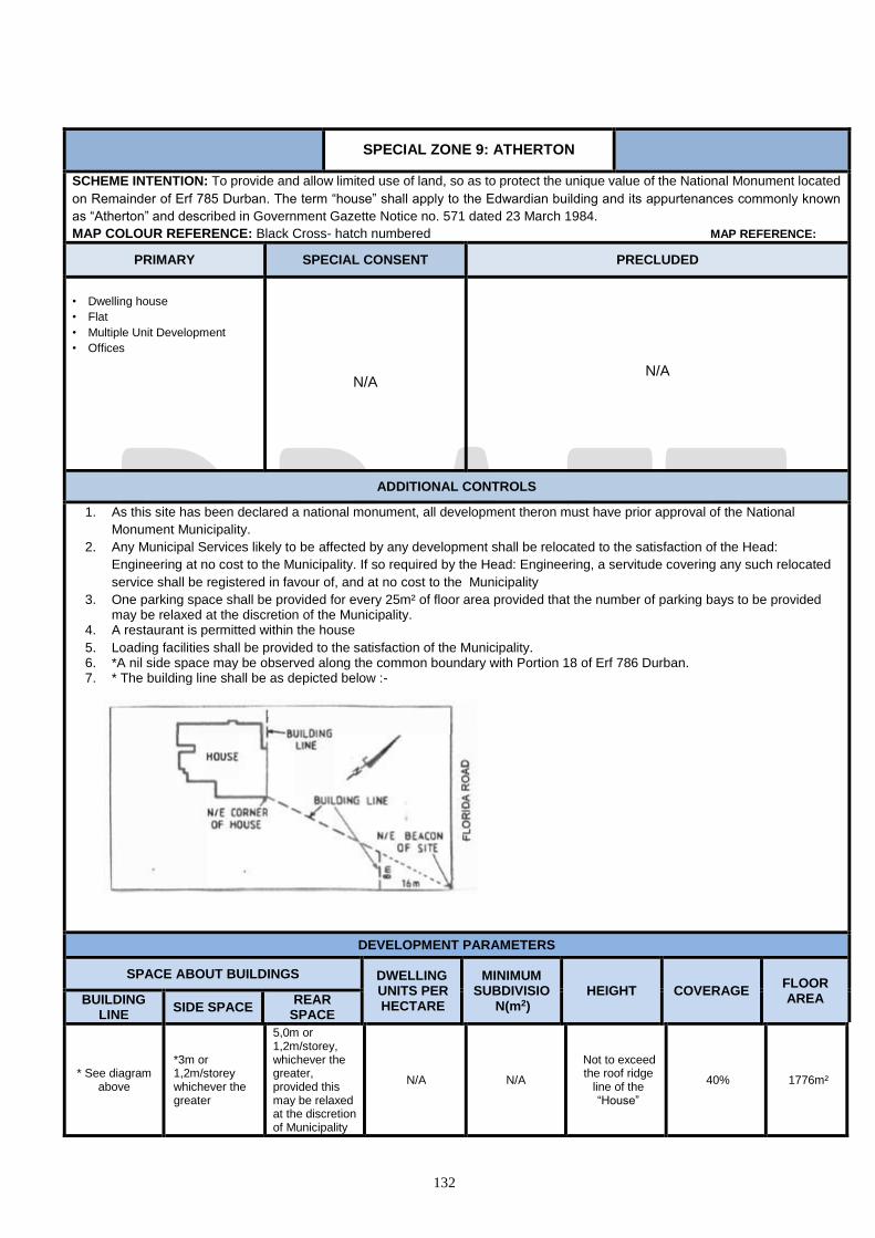
132
SPECIAL ZONE 9: ATHERTON
SCHEME INTENTION: To provide and allow limited use of land, so as to protect the unique value of the National Monument located
on Remainder of Erf 785 Durban. The term “house” shall apply to the Edwardian building and its appurtenances commonly known
as “Atherton” and described in Government Gazette Notice no. 571 dated 23 March 1984.
MAP COLOUR REFERENCE: Black Cross- hatch numbered MAP REFERENCE:
PRIMARY SPECIAL CONSENT PRECLUDED
• Dwelling house
• Flat
• Multiple Unit Development
• Offices
N/A
N/A
ADDITIONAL CONTROLS
1. As this site has been declared a national monument, all development theron must have prior approval of the National
Monument Municipality.
2. Any Municipal Services likely to be affected by any development shall be relocated to the satisfaction of the Head:
Engineering at no cost to the Municipality. If so required by the Head: Engineering, a servitude covering any such relocated
service shall be registered in favour of, and at no cost to the Municipality
3. One parking space shall be provided for every 25m² of floor area provided that the number of parking bays to be provided may be relaxed at the discretion of the Municipality.
4. A restaurant is permitted within the house
5. Loading facilities shall be provided to the satisfaction of the Municipality. 6. *A nil side space may be observed along the common boundary with Portion 18 of Erf 786 Durban. 7. * The building line shall be as depicted below :-
DEVELOPMENT PARAMETERS
SPACE ABOUT BUILDINGS DWELLING UNITS PER HECTARE
MINIMUM SUBDIVISIO
N(m2) HEIGHT COVERAGE
FLOOR AREA BUILDING
LINE SIDE SPACE
REAR SPACE
* See diagram above
*3m or 1,2m/storey whichever the greater
5,0m or 1,2m/storey, whichever the greater, provided this may be relaxed at the discretion of Municipality
N/A N/A
Not to exceed the roof ridge
line of the “House”
40% 1776m²
133
SPECIALZONE 10: GREYVILLE VILLAGE
SCHEME INTENTION: The purpose of this special zone is to provide a regulatory framework within which new development, appropriate to this
character, will be encouraged to retain the predominantly residential character of the area and to provide for the controlled introduction of mixed uses,
i.e. to permit small scale business activities which will assist economically in the upgrading of the area without unduly impacting on its residential
neighbourhood character. The architectural and townscape character of this area derives from its narrow lanes, small scale verandah cottages and low
garden walls.
MAP COLOUR REFERENCE: Black cross hatch with the zone number MAP REFERENCE:
PRIMARY SPECIAL CONSENT PRECLUDED
• Flat
• Dwelling house
• Any other land use considered by the Head: Development
Planning, Environment, and Management to be ancillary
to primary land uses
• All other land uses
ADDITIONAL CONTROLS
Special Zone 10: Greyville Village shall apply to the area bounded by First Avenue, Mathews Meyiwa, Lennox and Lilian Ngoyi Roads.
1. With the Special Consent of the Municipality, a business use may be combined with a residential use subject to the following conditions:-
(a) a portion of the accommodation on each site, to the satisfaction of the Head : Development Planning, Environment and Management, shall be
occupied as a dwelling unit. For the purposes of this special zone, a dwelling unit shall contain at least two bedrooms, a bathroom, a dining/living
room and a kitchen or kitchenette, with a minimum total floor area of 50m2; provided that Erven 48/49, 50/53 and 39 all of 1368, may be used
solely for business purposes;
(b) no external advertising shall be displayed on the site other than the name of the business or activity for which authority has been granted; provided
that no advertisement shall be displayed which in the opinion of the Head : Development Planning, Environment and Management will interfere
with the amenities of the neighbourhood and such advertisement shall not exceed 0.6m2 in area;
(c) no land or buildings may be used for the purpose of a bank, building society, other financial institutions, medical consulting rooms, with the
exception of land or building used for an Industry – Light purposes;
(d) the Head : Development Planning, Environment and Management may exempt an applicant from applying for Special Consent to conduct business
and residential uses on a property within the special zone, if he/she is satisfied that there will be no undue interference with the amenities of the
adjoining properties or those directly opposite the site.
2.
(a) One parking space shall be provided for each dwelling unit developed on a site and at least one parking space for each40m2 of floor area for
business purposes.
(b) The parking provision may be relaxed at the discretion of the Head: Development Planning, Environment and Management having regard to the
nature of the business use, the size and shape of the site and the position of buildings in existence on the site.
(c) Adequate provision shall be made for loading and unloading facilities to the satisfaction of the Head: Development Planning, Environment and
Management. 3. All building work undertaken on a site shall, in terms of its scale, architectural style and finishes, be in harmony with the existing character of the
area, to the satisfaction of the Head: Development Planning, Environment and Management; provided that contemporary interpretation or the use
of modern technology in new work shall not be precluded. 4. New front boundary walls shall:-
(a) not be constructed of precast concrete;
(b) not exceed 1.2m in height; provided that piers and railings attached to the wall for security shall be permitted provided further that, the combined
height of the wall and railing shall not exceed 2.0m;
(c) in their external appearance be designed and constructed in harmony with any building on the site and with the character of the area generally, to
the satisfaction of the Head : Development Planning, Environment and Management.
5. Coverage: Where an existing building is to be retained and a second building is to be erected, the maximum total coverage shall not exceed 60%. 6. The treatment of the open area of a site including landscaped and paved areas and driveways shall be to the satisfaction of the Head: Development
Planning, Environment and Management.
7. The Head : Development Planning, Environment and Management may relax or vary any of the aforementioned conditions where this can be shown
to be necessary in order to conserve an existing building on a site having either architectural, historic or artistic value and/or to accommodate
appropriate new development which will contribute to the upgrading of the land comprising the Zone.
DEVELOPMENT PARAMETERS
SPACE ABOUT BUILDINGS DWELLING UNITS
PER HECTARE
MINIMUM SUBDIVISIO
N(m2) HEIGHT COVERAGE
FLOOR AREA RATIO
BUILDING LINE
SIDE AND REAR SPACE
N/A N/A 1 per 200 400m2 2 50%; 0.8

134
SPECIAL ZONE 11: PIEDMONT
PARK OFFICES
SCHEME INTENTION: To provide, preserve, use land or buildings for development of distinct office area, as listed below.
MAP COLOUR REFERENCE: Black cross hatch with zone number MAP REFERENCE:
PRIMARY SPECIAL CONSENT PRECLUDED
Office
Any other land use considered by the Head:
Development Planning, Environment, and
Management to be ancillary to the primary land
use
• All other land uses
ADDITIONAL CONTROLS
1. Special Zone 13: Piedmont Park Offices apply to Erf 935, Brickfield, situated at 687 King Cetshwayo Highway, Durban.
2. No portion of a building shall be used for the purposes of a bank, building society, shop or industrial activity provided that portion of
one building may be used as a crèche, a shop (which shall not exceed 100m2 in extent) and a restaurant for the benefit of the
occupants of this special zone.
3. A caretaker’s flat may be constructed provided that no less than 1 car parking space shall be provided for the use by the occupants
of the flat.
4. Total development of this special zone shall not exceed 20 700m2 gross floor area and shall comprise of not more than 5 buildings,
one of which may have a gross floor area of not more than 7 500m2. The remaining gross floor area may be developed in 3 or 4
buildings provided that none of these buildings shall have a gross floor area in excess of 5 000m2 and no one storey thereof shall
exceed 1 500m2 gross floor area.
5. 5 storey buildings greater than 5 000m2 but not exceeding 7 500m2 in extent, shall be erected in the south-eastern quadrant of this
special zone.
6. On-site parking shall be provided at the rate of one space for every 25m2 of floor area of building (calculated in accordance with the
provisions of Section 8; provided that the Head: Development Planning, Environment and Management may at his/her discretion
vary these requirements.
7. Loading and off-loading facilities shall be provided in terms of section 8 of this scheme.
8. The land comprising this Zone shall be landscaped to the satisfaction of the Head: Development Planning, Environment and
Management.
9. The upgrading of the intersection of Piedmont Road and King Cetshwayo Highway shall be carried out subject to the following
conditions :-
(a) Prior to submission and approval of detailed building plans, the full layout and vertical profiles of all proposed roads, including
Piedmont Road where it borders this special zone up to and including its intersection with King Cetshwayo Highway shall be
submitted to the Head: Development Planning, Environment and Management for approval.
(b) The intersection referred to in (a) shall be upgraded to the satisfaction of the Head: Development Planning, Environment and
Management by and at the cost of the developers of this special zone.
(c) A 3.0m wide verge shall be provided on both sides of Piedmont Road to the satisfaction of the Head: Development Planning,
Environment and Management by and at the cost of the developers of this special zone.
(d) The vehicular carriageways shall be designed to the satisfaction of the Head: Development Planning, Environment and
Management. The design details shall be submitted for consideration when the Municipality is sought to develop the land
comprising this special zone.
10. In developing this special zone the developers shall comply with the Head: Development Planning, Environment and Management
standard flooding guideline entitled “Information to be provided in relation to the development of properties within the 1:50 Year
Flood Plain”.
11. In developing this special zone subdivision thereof would be considered provided the developers submit to the Land Use
Management Department a subdivisional layout plan which shall indicate the maximum gross floor area per subdivision.
12. No access to any subdivision shall be taken off King Cetshwayo Highway.
DEVELOPMENT PARAMETERS
SPACE ABOUT BUILDINGS MAX. NO. OF BUILDINGS
MINIMUM SUBDIVISION
(m2) HEIGHT IN STOREYS
COVERAGE (%)
GROSS FLOOR
AREA (GFA) BUILDING
LINE SIDE AND
REAR SPACE
N/A N/A 5 N/A
4 in the case of buildings < 5 000m2 in extent,
15% Maximum : 20 700m2 5 in the case of the
building > 5 000m2 but not > 7 500m2 in extent.
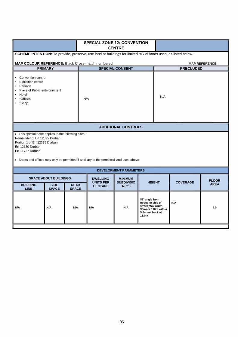
135
SPECIAL ZONE 12: CONVENTION
CENTRE
SCHEME INTENTION: To provide, preserve, use land or buildings for limited mix of lands uses, as listed below.
MAP COLOUR REFERENCE: Black Cross- hatch numbered MAP REFERENCE:
PRIMARY SPECIAL CONSENT PRECLUDED
• Convention centre
• Exhibition centre
• Parkade
• Place of Public entertainment
• Hotel
• *Offices
• *Shop
N/A N/A
ADDITIONAL CONTROLS
This special Zone applies to the following sites:
Remainder of Erf 12395 Durban
Portion 1 of Erf 12395 Durban
Erf 12380 Durban
Erf 11727 Durban
Shops and offices may only be permitted if ancillary to the permitted land uses above
DEVELOPMENT PARAMETERS
SPACE ABOUT BUILDINGS DWELLING UNITS PER HECTARE
MINIMUM SUBDIVISIO
N(m2) HEIGHT COVERAGE
FLOOR AREA BUILDING
LINE SIDE
SPACE REAR
SPACE
N/A N/A N/A N/A N/A
59˚ angle from opposite side of street(max width 30m) or 110m with a 5.0m set back at 15.0m
N/A
8.0

136
SPECIAL ZONE 13: ST. IVES ROAD
SCHEME INTENTION: To provide, preserve, use land or buildings for a limited mix of land-uses, as listed below.
MAP COLOUR REFERENCE: Black cross hatch with zone number MAP REFERENCE:
PRIMARY SPECIAL CONSENT PRECLUDED
• Boarding House
• Conservation Area
• Dwelling House
• Flat
• Multiple Unit Development
• Any other land use considered by the Head:
Development Planning, Environment, and
Management to be ancillary to the primary land
use
• All other land uses
ADDITIONAL CONTROLS
This special zone shall apply to the following properties situated at St. Ives Road / River Avenue / Wakesleigh Road which are to be consolidated in the event of the total number residential units exceeds 45:-
• Portion of Rem of Erf 516, Bellair • Remainder of Portion 26 of Erf 516, Bellair • Rem of 11 of Erf 517, Bellair • Portion 9 of Erf 531, Bellair • Portions 16-21 of 1 of Erf 531, Bellair
• Portion 3 of Erf 535, Bellair • Portions 1-8 of Erf 534, Bellair • Portions 20 and 21 of 9 of Erf 534, Bellair • Rem of 9 of Erf 534, Bellair • Portions 10-17 of Erf 534, Bellair
1. Should the properties that comprise this Zone not be consolidated then only one dwelling unit shall be constructed on each of the following properties:- • Portion 9 of Erf 531, Bellair • Portions 16 - 21 of 1 of Erf 531, Bellair • Portion 3 of Erf 535, Bellair • Portions 1 - 8 of Erf 534, Bellair • Portions 20 and 21 and Rem of 9, all of Erf 534, Bellair (which are to be Consolidated) • Portions 10 - 17 of Erf 534, Bellair • Rem of Erf 534, Bellair
2. Provided that a maximum of 9 multiple housing units may be constructed on Portion of Remainder of Erf 516, Bellair and a maximum
of 5 multiple housing units may be erected on each of Remainder of Portion 26 of Erf, 516 Bellair and Remainder of Portion 11 of Erf 517, Bellair.
1. On-site parking shall be provided in terms of Section 8. of this scheme.
2. Where development within this special zone does not exceed 45 residential units and the properties comprising this zone remain unconsolidated, there will be no requirement for any road infrastructure improvements to St. Ives Road, River Avenue and Wakesleigh Road.
3. However, where development within the Zone exceeds 45 residential units then the properties comprising this special zone shall be consolidated and the following road infrastructure improvements undertaken to the satisfaction of the of the Head : eThekwini Transport Authority and the Head : Engineering Services:- (a) The existing St. Ives Road intersection with Wakesleigh Road is to be closed and superseded by a new River Avenue/
Wakesleigh Road/ Reyburn Avenue intersection incorporating a 26.7m right turn refuge lane in Wakesleigh Road. (b) The re-alignment of St. Ives Road and River Avenue and the new intersection arrangements are shown on drawing No. 0707/2/A
dated 14th August, 2007 and attached to the traffic assessment report prepared by DJ Haliburton dated August, 2007 and referenced DJH Ref 0707.
8. The sensitive ecological area’s identified in the environmental basic assessment report prepared by McFerran and Associates for EIA No. DM/0095/007 shall remain undeveloped and shall be surveyed and protected by the registering of environmental conservation servitude there over.
DEVELOPMENT PARAMETERS
LAND USE
SPACE ABOUT BUILDINGS DWELLING UNITS
PER HECTARE
MINIMUM SUBDIVISI
ON(m2)
HEIGHT IN STOREYS
COVERAGE FLOOR
AREA RATIO
BUILDING LINE
SIDE AND REAR SPACE
Dwelling House
3.0m;
(2nd – 3rd storey = 1.7m)
1.0m;
(2nd – 3rd storey = 1.7m)
If properties not consolidate = 45 units; If properties
400 2 50% N/A

137
Flat 7.5m 4.5m consolidate = 430 units
900 4 1.0
SPECIAL ZONE 14: STONEBRIDGE
SCHEME INTENTION: To provide or use land or buildings for :-
A mixed use business area that will accommodate residential, office, commercial and recreational activities that is not detrimental to
the amenity of the area.
MAP COLOUR REFERENCE: Black cross hatch with zone number MAP REFERENCE:
PRIMARY SPECIAL CONSENT PRECLUDED
• Crèche
• Dwelling house
• Educational Establishment
• Flat
• Flea Market
• Garden Nursery
• Health and Beauty Clinic
• Health Studio
• Hotel
• Industry-Light
• Institution
• Office
• Office-Medical
• Place of Public Entertainment
• Pet Grooming Parlour
• Restaurant/Fast Food Outlet
• Shop
• Worship
• Betting Depot
• Fuelling and Service Station
• Motor Display Area
• Motor Workshop
• Special Building
All other uses
ADDITIONAL CONTROLS
*No subdivision or consolidation, other than the consolidation and re-subdivision of Erven 915, 916, and 917 within this Special Zone shall
have an area greater than 2000m².
*No portion of any building erected in this zone shall exceed 9,0 metres in height above natural ground level or ground level at the time
that an application for authority to erect a building is made, whichever is the lower.
The Municipality may by special consent relax the building line, side space, and rear space requirements
DEVELOPMENT PARAMETERS
SPACE ABOUT BUILDINGS DWELLING UNITS PER HECTARE
MINIMUM SUBDIVISI
ON(m2) HEIGHT COVERAGE
FLOOR AREA RATIO
BUILDING LINE
SIDE SPACE
REAR SPACE
3,0 m 3,0 m 5,0m N/A *900m² *9,0 metres 50% n/a
1. Parking shall be in accordance with Section 8 of this scheme.

138

139
SPECIAL ZONE 15: UMGENI BUSINESS
PARK
SCHEME INTENTION: To provide, preserve, use land or buildings for:-
A mixture of commercial, industrial, educational and residential uses that apply to the Business Park within the Umgeni Road
precinct.
MAP REFERENCE: MAP REFERENCE:
PRIMARY SPECIAL CONSENT PRECLUDED
• Crèche • Dwelling unit (excluding Portions 3, 4, 7 and 8 of
Erf 251 Springfield, except that one dwelling unit may be permitted on each site/leasehold to accommodate a manager, foreman, caretaker or security personnel)
• Hotel • Light Industrial • Offices • Place of Entertainment • Institution • Educational Establishment • Place of Worship • Flat (excluding Portions 3, 4, 7 and 8 of Erf 251
Springfield) • Restaurant • Shop
• Fuelling and Service Station
• All other uses not mentioned in the
Primary or precluded columns.
• General Industry
• Extractive Industry
• Noxious Industry
ADDITIONAL CONTROLS – LAND USE
1. The total floor area of all buildings on a site shall not be greater than that calculated in accordance with a plot area ratio of 4,0 to 1 excepting for Portions 3, 4, 7 and 8 of Erf 251 Springfield which shall have a maximum plot area ratio of 0,7 to 1 ; provided that the total floor area of all buildings or portions of buildings on a site which are designed or intended for non-residential use shall not be greater than that calculated in accordance with a plot area ratio of 2,0 to 1 excepting for Portions 3, 4, 7 and 8 of Erf 251 Springfield which shall have a maximum plot area ratio of 0,7 to1.
2. 100% coverage may be permitted excepting Portions 3, 4, 7 and 8 of Erf 251 Springfield which shall have a maximum permitted coverage
of 90%.
3. On-site parking for vehicles shall be provided as follows :-
(a) In the case of residential development not less than one parking space shall be provided for each dwelling unit and additional parking shall be provided for visitors at the ratio of one parking space for every three dwelling units or part thereof;
(b) in the case of shops and offices not less than one parking space shall be provided for every 30m5 of the gross floor area of such shops and offices; and
(c) in the case of industrial buildings not less than one parking space shall be provided for every 100m5 of gross floor area of such industrial buildings; provided that the Head: Development Planning, Environment and Management may at his discretion vary any of these requirements.
4. Loading and off-loading facilities shall be provided to the satisfaction of the Head: Development Planning, Environment and Management.
DEVELOPMENT PARAMETERS
SPACE ABOUT
BUILDINGS DWELLING UNITS
PER HECTARE
MINIMUM SUBDIVISION
(m2) HEIGHT
COVERAGE
(%)
FLOOR AREA RATIO BUILDING
LINE
SIDE AND REAR
SPACE
Nil 900m² 15 meters
SPECIAL ZONE 16: RIVERHORSE VALLEY
SCHEME INTENTION: To provide, preserve, use land or buildings for a limited mix of land-uses, as listed below.
MAP COLOUR REFERENCE: Black cross hatch with zone number MAP REFERENCE:
1. Zone No. 16: Riverhorse Valley shall apply to the following properties:-
The Final Development Concept Plan, Ref. RHVBE 09/FDCP/03-2017 indicates in broad terms the land use treatment of the Zone which may be
varied with the written consent of the Head: Development Planning and Management.
2. The following controls shall apply within the Industrial and Commercial Land use component depicted on the Final Development Concept Plan:-
PRIMARY SPECIAL CONSENT PRECLUDED
• Agricultural Activity
• Crèche
• Educational Establishment
• Flat
• Industrial - Light
• Laundry
• Office
• Parkade
• Place of Public Entertainment
• Private Open Space
• Restaurant / Fast-food Outlet
• Shop
• Transport Depot
• Betting Depot,
• Special Building
• Any other use authorised in terms of Section
9.4 (Important Buildings and Objects)
• All other land uses
ADDITIONAL CONTROLS – LAND USE
• No buildings within the Industrial and Commercial Land use component other than in Area A shall be beneficially occupied before the interchange
on the N2 Freeway to be constructed within this special zone is open to traffic.
DEVELOPMENT PARAMETERS
SPACE ABOUT BUILDINGS DWELLING UNITS PER HECTARE
MINIMUM ERF
SIZE (m2)
HEIGHT IN STOREYS
COVERAGE (%)
FLOOR AREA RATIO BUILDING LINE
SIDE AND REAR SPACE
Nil Nil N/A 900m2 25.0m N/A 2.0
ADDITIONAL CONTROLS – DEVELOPMENT PARAMETER
(a) Height: Where a portion of a subdivision is contiguous to or within 50.0m of any residential development abutting this Zone, the public open space
abutting the uMhlangane River, and the Hulett’s Bush public open space, no building or structure on that portion of a subdivision which lies within
50.0m shall exceed 12.0m above finished ground level in height, provided, further, that the Head: Development Planning, Environment and
Management in consultation with the Deputy Head: Environment may at his/her discretion relax this requirement.
(b) Building Line: No part of any building shall be erected within 10.0m of the street line on any subdivision which has a frontage to the N2 Freeway
or within 7.5m of the street line on any subdivision which has frontage to a street adjacent to residential development: provided, that the Head:
Development Planning, Environment and Management may, at his/ her discretion, relax this requirement; provided further that the approval of the
Provincial Road Engineer shall be obtained to relax the 10.0m building line to the N2 Freeway.
(c) Side and Rear Space: Where a subdivision is contiguous to the public open space abutting the uMhlangane River, and the Hulett’s Bush public
open space, and any residential development, no buildings, loading and unloading facilities or storage shall be permitted within 10.0m of such
boundary provided that the Head : Development Planning, Environment and Management in consultation with the Deputy Head : Environment may
relax this requirement; provided further, that these areas shall be landscaped to the satisfaction of the Head: Development Planning, Environment
and Management in consultation with the Deputy Head: Environment.
(d) Parking: shall be provided on-site at the ratio of one bay per 30m2 of the gross floor area of shops and offices; and one bay per 100m2 of the gross
floor area of industrial buildings and uses. In the case of any other use parking shall be provided to the satisfaction of the Head: Development
Planning, Environment and Management.

140
(e) Loading and off-loading facilities: shall be provided in terms of Section 8 of this scheme.
(f) The Head: Development Planning, Environment and Management may, at his/her discretion, vary any of the requirements set out in paragraphs
(d) and (e) above.
(g) There shall be no direct vehicular access from any subdivision to the Newlands East / KwaMashu Arterial Link Road, provided that the Head:
Development Planning, Environment and Management may relax this requirement.
(h) The interface area between the industrial and commercial land use component and adjacent residential areas shall be screened and landscaped to
the satisfaction of the Head: Development Planning, Environment and Management.
(i) The Industrial and Commercial Land use component in Area A depicted on the revised Final Development Concept Plan (Ref: RHVBE 09/FDCP/03-
2017) shall be developed for office and/ or shopping and/or warehousing purposes along its frontage to uMhlangane Road and to a depth of not
less than 15.0m from that frontage, provided that in the case of warehousing, the building shall be designed as to accommodate the office
component along it’s frontage to uMhlangane Road; provided further that the architectural style and finishes of any warehousing building erected
there-along shall be to the satisfaction of the Head: Development Planning, Environment and Management; provided further the frontage shall be
landscaped to the satisfaction of the Head: Development Planning, Environment and Management.
(j) The development of Portion 19 of Erf 2 of Duikerfontein, situated at 550 Prince Mhlangana Road shall be restricted to office use only.
a
(k) Access into and out of Portion 19 of Erf 2 Duikerfontein, situated at 550 Prince Mhlangana Road shall be off Prince Mhlangana Road to the
satisfaction of the Head: eThekwini Transport Authority.
3. The following controls shall apply within the Direct Access Motor Service Centre depicted on the Final
Development Concept Plan:-
PRIMARY SPECIAL CONSENT PRECLUDED
• Fuelling and Service Station
• Restaurant / Fast-food Outlet
• *Place of Public Entertainment
• Private Open Space
• Motor Display Area • Parkade • Special Building
• Any other use authorised in terms of Section
9.4 (Important Buildings and Objects)
• All other uses
ADDITIONAL CONTROLS
• *Place of Public Entertainment shall be ancillary uses to that of a Fuelling and Service Station.
• The site shall be landscaped to the satisfaction of the Head: Development Planning, Environment and Management.
DEVELOPMENT PARAMETERS
SPACE ABOUT BUILDINGS DWELLING UNITS PER HECTARE
MINIMUM ERF
SIZE (m2)
HEIGHT IN STOREYS
COVERAGE (%)
FLOOR AREA RATIO BUILDING LINE
SIDE AND REAR SPACE
see (b) below Nil 9 000m2 2 30%
(a) Height: 3 storeys may be permitted by the Special Consent of the Municipality on a sloping site.
(b) Building Line: the building line to the N2 Freeway and the Newlands East/KwaMashu Arterial Link Road shall be to the satisfaction of the
Provincial Roads Engineer;
(c) Parking shall be provided in terms of Section 8. of this scheme.
(d) The site shall be landscaped to the satisfaction of the Head: Development Planning, Environment and Management.
(e) In respect of a Fuelling and Service Station, the provisions of sub-section 9.2 of this scheme shall apply to this special zone; provided that access
from the N2 Freeway shall be in accordance with the Department of Transport’s guidelines for Direct Access Motor Service Centres.
4. The following controls shall apply within the Mixed Use Activity Node depicted on the Final Development Concept Plan:-
PRIMARY SPECIAL CONSENT PRECLUDED
• Agricultural Activity
• Crèche
• Dwelling House
• Educational Establishment
• Flat
• Hotel
• Industrial - Light
• Institution
• Laundry
• Multiple Unit Development
• Office
• Betting Depot
• Fuelling and Service Station
• Special Building
• Any other use authorised in terms of Section
9.4 (Important Buildings and Objects)
• All other uses

141
• Parkade
• Place of Public Entertainment
• Place of Public Worship
• Private Open Space
• Restaurant / Fast-food Outlet
• Shop
• Transport Depot
DEVELOPMENT PARAMETERS
SPACE ABOUT BUILDINGS DWELLING UNITS PER HECTARE
MINIMUM ERF
SIZE (m2)
HEIGHT IN STOREYS
COVERAGE FLOOR
AREA RATIO BUILDING LINE SIDE AND
REAR SPACE
Nil Nil N/A 240m2 4 75% 1.5
ADDITIONAL CONTROLS - DEVELOPMENT PARAMETERS
(a) Erf: the shape of any subdivision shall be to the satisfaction of the Head: Development Planning, Environment and Management.
(b) Floor Area Ratio: may be increased to 3.0 to 1; provided further that for every square metre of floor area in excess of the floor area ratio of 1.5
to 1, 50% thereof shall be used for residential purposes.
(c) Height: the Municipality may, by Special Consent, if it is satisfied that there will be no material interference with amenities of the neighbourhood,
existing or contemplated by the scheme, authorise a building which is more than 4 stories in height above ground level; provided further, that
where a Erf is contiguous to or within 50.0m of any residential development, or any public open space abutting uMhlangane River and the Hulett’s
Bush Open Space, no building or structure shall exceed 2 storeys above ground level, provided further, that architectural features may exceed
such height to the satisfaction of the Head: Development Planning, Environment and Management.
(d) Building Line: No part of any building shall be erected within 10.0m of the street line on any Erf which has a frontage to the N2 Freeway or within
7.5m of the street line on any subdivision which has a frontage to a street adjacent to residential development; provided that, the Head :
Development Planning, Environment and Management may, at his / her discretion, relax this requirement; provided further, that the approval of
the provincial Road Engineer shall be obtained to relax the 10.0m building line to the N2 Freeway.
(e) Side and Rear Space: Where a subdivision is contiguous to the public open space abutting the uMhlangane River, and the Hulett’s Bush public
open space, and any residential development, no buildings, loading and unloading facilities or storage shall be permitted within 10.0m of such
boundary; provided that the Head: Development Planning, Environment and Management, may at his / her discretion and in consultation with
the Deputy Head: Environment relax this requirement; provided further, that these area’s shall be landscaped to the satisfaction of the Head:
Development Planning, Environment and Management in consultation with the Deputy Head: Environment.
(f) Parking: shall be provided on-site at the ratio of one bay per dwelling unit in the case of residential development; one bay per 30m2 of gross floor
area of shops and offices; and one bay per 100m2 of gross floor area of industrial buildings and uses. In the case of any other use parking shall
be provided to the satisfaction of The Head: Development Planning, Environment and Management.
(g) Loading and off-loading facilities: shall be provided in terms of Section 8. of this scheme.
(h) The Head: Development Planning, Environment and Management may, at his / her discretion, vary any of the requirements set out in paragraphs
(f) and (g).
(i) There shall be no direct access from any subdivision to the Newlands East/KwaMashu Arterial Link Road; provided that the Head: Development
Planning and Management may relax this requirement.
(j) Where a residential use is proposed in addition to any other uses within a building, the residential use shall be located above the ground floor
storey.
5. The following controls shall apply within the Residential Component depicted on the Final Development Concept Plan:-
PRIMARY SPECIAL CONSENT PRECLUDED
• Agricultural Activity
• Dwelling House
• Educational Establishment
• Flat
• Multiple Unit Development
• Private Open Space
• Crèche
• Laundry
• Office
• Parkade
• Place of Public Worship
• Restaurant / Fast-food Outlet
• Shop
• Special Building
• Any other use authorised in terms of Section
9.4 (Important Buildings and Objects)
• All other uses
ADDITIONAL CONTROLS – LAND USE

142
(a) The residential occupant of a dwelling unit may conduct therein a profession, occupation or trade, provided that such profession, occupation or
trade does not, in the opinion of The Head: Development Planning, Environment and Management, cause an interference with the amenities of the
neighbourhood by reason of noise, vibration, smell, fumes, smoke, soot, ash, dust, grit or any other causes; provided further, that the principle use
of the site shall remain residential.
DEVELOPMENT PARAMETERS
SPACE ABOUT BUILDINGS DWELLING UNITS PER HECTARE
MINIMUM SUBDIVISION (m2)
HEIGHT IN STOREYS
COVERAGE FLOOR
AREA RATIO BUILDING LINE
SIDE AND REAR SPACE
Nil Nil N/A
Detached or a Semi-detached dwelling unit
= 100m2
Detached or a Semi-detached dwelling unit
= 3 75% N/A
Flat = 400m2 Flat = 4
ADDITIONAL CONTROLS - DEVELOPMENT PARAMETERS
(a) Erf Size: where a subdivision is contiguous to, or across a road from an existing residential zone, such Erf shall not be less than the area of any
Erf permitted in the existing residential zone; provided further, that the shape of any subdivision shall be to the satisfaction of the Head:
Development Planning and Management.
(b) Area B depicted on the Final Development Concept Plan shall be developed in accordance with the controls applicable to a Special Residential
400 zone.
(c) Building Line and Side and Rear Space: in the case of residential development abutting the Hulett’s Bush public open space where a 5.0m
rear space requirement shall apply; provided that, where an Erf is to be used for a purpose other than residential, the building line shall be 3.0m;
provided further, that the Head: Development Planning, Environment and Management may, at his / her discretion relax this requirement.
(d) Parking: shall be provided at the ratio of one parking space per dwelling unit; provided that the Head: Development Planning, Environment and
Management may, at his / her discretion vary this requirement.
(e) The residential occupant of a dwelling unit may conduct therein a profession, occupation or trade, provided that such profession, occupation or
trade does not, in the opinion of The Head : Development Planning and Management, cause an interference with the amenities of the
neighbourhood by reason of noise, vibration, smell, fumes, smoke, soot, ash, dust, grit or any other causes; provided, further, that the principle
use of the site shall remain residential.
6. The following controls shall apply within the Fuelling and Service Station land use component depicted on the Final Development Concept Plan as well as any Fuelling and Service Station granted by way of Special Consent within the Industrial / Commercial land use component:-
PRIMARY SPECIAL CONSENT PRECLUDED
• Fuelling and Service Station
• Restaurant / Fast-food Outlet
• *Place of Public Entertainment
• Private Open Space
• Parkade
• Motor Display Area
• Transport Depot
• Special Building • Any other use authorised in terms of Section
9.4 (Important Buildings and Objects)
• All other uses
DEVELOPMENT PARAMETERS
SPACE ABOUT BUILDINGS DWELLING UNITS PER HECTARE
MINIMUM SUBDIVISION
(m2)
HEIGHT IN STOREYS
COVERAGE FLOOR
AREA RATIO BUILDING LINE SIDE AND
REAR SPACE
Nil Nil N/A 3000m2 2 45% 0.45
(a) *Place of Public Entertainment shall be ancillary uses to that of a Fuelling and Service Station.
(b) Height: 3 storeys may be permitted by the Special Consent of the Municipality on a sloping site.
(c) Building Line: the building line to the Effingham/Avoca Link Road shall be to the satisfaction of the Head: Development Planning,
Environment and Management.
(d) Parking: shall be provided in terms of Section 8. of this scheme.
(e) The site shall be landscaped to the satisfaction of The Head: Development Planning, Environment and Management.
(f) In respect of a Fuelling and Service Station, the provisions of sub-section 9.2 of this scheme shall apply to this special zone.
(g) The subdivision containing the fuelling and service station shall not be less than in extent.
GENERAL CONTROLS

143
7. (a) The full layout and vertical profiles of all proposed roads including the proposed Newlands East / KwaMashu Arterial Link Road and the
interchange on the N2 Freeway shall be submitted to the Head: Development Planning, Environment and Management for approval and the
Municipality shall not authorise the erection of any building prior to that approval being given; provided that the proposed interchange on the
N2 Freeway shall also require the prior approval of the Department of Transport (DoT).
(b) The Newlands East/KwaMashu Arterial Link Road shall be constructed by and at the cost of the developer to the satisfaction of The Head:
Development Planning, Environment and Management.
(c) Neither Park Station Road nor Storm Road shall be connected directly to the Newlands East/KwaMashu Arterial Link Road.
(d) Effingham Road shall be connected to Prince Umhlangana Road to the satisfaction of the Head: eThekwini Transport Authority.
4. Any public open space depicted on the Final Development Concept Plan shall be used for either recreation or conservation purposes to the
satisfaction of The Head: Development Planning, Environment and Management.
5. Screening and landscaping of those sites which abut the N2 Freeway in Areas C, D and E shall be undertaken by and at the cost of the
developers in accordance with the visual impact assessment approved by The Head: Development Planning and Management and the Town and
Regional Planning Commission.
10. Development of the land comprising this Zone shall be in accordance with the conditions stipulated in the Environmental Impact Assessment
approval.
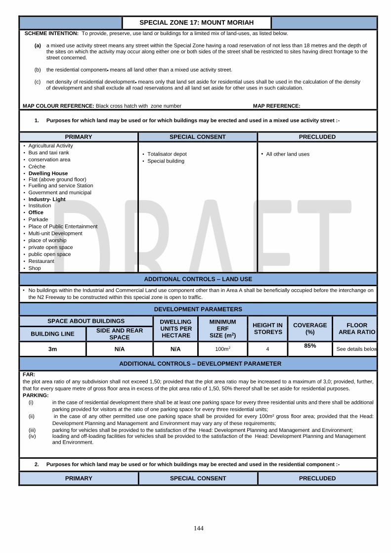
144
SPECIAL ZONE 17: MOUNT MORIAH
SCHEME INTENTION: To provide, preserve, use land or buildings for a limited mix of land-uses, as listed below.
(a) a mixed use activity street means any street within the Special Zone having a road reservation of not less than 18 metres and the depth of the sites on which the activity may occur along either one or both sides of the street shall be restricted to sites having direct frontage to the street concerned.
(b) the residential component@ means all land other than a mixed use activity street. (c) net density of residential development@ means only that land set aside for residential uses shall be used in the calculation of the density of development and shall exclude all road reservations and all land set aside for other uses in such calculation.
MAP COLOUR REFERENCE: Black cross hatch with zone number MAP REFERENCE:
1. Purposes for which land may be used or for which buildings may be erected and used in a mixed use activity street :-
PRIMARY SPECIAL CONSENT PRECLUDED
• Agricultural Activity
• Bus and taxi rank
• conservation area
• Crèche
• Dwelling House • Flat (above ground floor) • Fuelling and service Station
• Government and municipal
• Industry- Light
• Institution
• Office
• Parkade
• Place of Public Entertainment
• Multi-unit Development
• place of worship
• private open space
• public open space
• Restaurant
• Shop
• Totalisator depot
• Special building
• All other land uses
ADDITIONAL CONTROLS – LAND USE
• No buildings within the Industrial and Commercial Land use component other than in Area A shall be beneficially occupied before the interchange on
the N2 Freeway to be constructed within this special zone is open to traffic.
DEVELOPMENT PARAMETERS
SPACE ABOUT BUILDINGS DWELLING UNITS PER HECTARE
MINIMUM ERF
SIZE (m2)
HEIGHT IN STOREYS
COVERAGE (%)
FLOOR AREA RATIO BUILDING LINE
SIDE AND REAR SPACE
3m N/A N/A 100m2 4 85%
See details below
ADDITIONAL CONTROLS – DEVELOPMENT PARAMETER
FAR:
the plot area ratio of any subdivision shall not exceed 1,50; provided that the plot area ratio may be increased to a maximum of 3,0; provided, further,
that for every square metre of gross floor area in excess of the plot area ratio of 1,50, 50% thereof shall be set aside for residential purposes.
PARKING:
(i) in the case of residential development there shall be at least one parking space for every three residential units and there shall be additional
parking provided for visitors at the ratio of one parking space for every three residential units;
(ii) in the case of any other permitted use one parking space shall be provided for every 100m² gross floor area; provided that the Head:
Development Planning and Management and Environment may vary any of these requirements;
(iii) parking for vehicles shall be provided to the satisfaction of the Head: Development Planning and Management and Environment; (iv) loading and off-loading facilities for vehicles shall be provided to the satisfaction of the Head: Development Planning and Management
and Environment.
2. Purposes for which land may be used or for which buildings may be erected and used in the residential component :-
PRIMARY SPECIAL CONSENT PRECLUDED
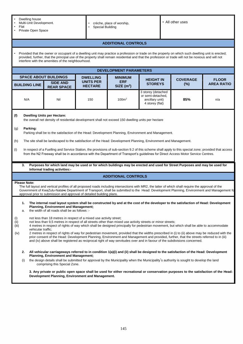
145
• Dwelling house • Multi-Unit Development. • Flat • Private Open Space
• crèche, place of worship, • Special Building
• All other uses
ADDITIONAL CONTROLS
• Provided that the owner or occupant of a dwelling unit may practice a profession or trade on the property on which such dwelling unit is erected;
provided, further, that the principal use of the property shall remain residential and that the profession or trade will not be noxious and will not interfere with the amenities of the neighbourhood.
DEVELOPMENT PARAMETERS
SPACE ABOUT BUILDINGS DWELLING UNITS PER HECTARE
MINIMUM ERF
SIZE (m2)
HEIGHT IN STOREYS
COVERAGE (%)
FLOOR AREA RATIO BUILDING LINE
SIDE AND REAR SPACE
N/A Nil 150 100m2
3 storey (detached or semi-detached,
ancillary unit) 4 storey (flat)
85% n/a
(f) Dwelling Units per Hectare:
the overall net density of residential development shall not exceed 150 dwelling units per hectare
(g) Parking:
Parking shall be to the satisfaction of the Head: Development Planning, Environment and Management.
(h) The site shall be landscaped to the satisfaction of the Head: Development Planning, Environment and Management.
(i) In respect of a Fuelling and Service Station, the provisions of sub-section 9.2 of this scheme shall apply to this special zone; provided that access
from the N2 Freeway shall be in accordance with the Department of Transport’s guidelines for Direct Access Motor Service Centres.
3. Purposes for which land may be used or for which buildings may be erected and used for Street Purposes and may be used for
Informal trading activities:-
ADDITIONAL CONTROLS
Please Note: The full layout and vertical profiles of all proposed roads including intersections with MR2, the latter of which shall require the approval of the Government of KwaZulu-Natal=s Department of Transport, shall be submitted to the Head: Development Planning, Environment and Management for approval prior to submission and approval of detailed building plans.
1. The internal road layout system shall be constructed by and at the cost of the developer to the satisfaction of Head: Development Planning, Environment and Management;
a. the width of all roads shall be as follows :- (i) not less than 18 metres in respect of a mixed use activity street; (ii) not less than 9,5 metres in respect of all streets other than mixed use activity streets or minor streets; (iii) 4 metres in respect of rights of way which shall be designed principally for pedestrian movement, but which shall be able to accommodate vehicular traffic; (iv) 2 metres in respect of rights of way for pedestrian movement, provided that the widths prescribed in (i) to (ii) above may be reduced with the
prior consent of the Head: Development Planning, Environment and Management and provided, further, that the streets referred to in (iii) and (iv) above shall be registered as reciprocal right of way servitudes over and in favour of the subdivisions concerned.
2. All vehicular carriageways referred to in condition 1(a)(i) and (ii) shall be designed to the satisfaction of the Head: Development Planning, Environment and Management;
(i) the design details shall be submitted for approval by the Municipality when the Municipality’s authority is sought to develop the land
comprising this Special Zone.
3. 3. Any private or public open space shall be used for either recreational or conservation purposes to the satisfaction of the Head:
Development Planning, Environment and Management.
4.

146
SPECIAL ZONE 18: UMGENI RIVER BIRD
AND ZOOLOGICAL PARK
SCHEME INTENTION: To provide, preserve, use land or buildings for a limited mix of land-uses, as listed below.
MAP COLOUR REFERENCE: Black cross hatch with zone number MAP REFERENCE:
PRIMARY SPECIAL CONSENT PRECLUDED
• *Conservation Area
• *Conference Facility
• Garden Nursery
• *Restaurant/ Fast Food
• *Shop
• *Zoological Garden
• Any use considered by the Head : DPEM to
be ancillary to the uses referred to in
paragraph 2(a) below or likely to encourage
the use of the land comprising this special
zone
• Any other land use considered by the Head:
Development Planning, Environment, and
Management to be ancillary to the primary land use
• All other uses
ADDITIONAL CONTROLS
Zone No. 16 shall apply to the following properties :- (a) Portion 4 of Erf 221, Durban North
(b) Portion 6 of Erf 221, Durban North
(c) Portion 46 of Erf 223, Durban North
(d) Portion 2 of Erf 224, Durban North
(e) Portion 4 of Erf 227, Durban North
The conditions applicable to this Zone shall be as follows :-
1. The sites described in (a) to (e) above shall be consolidated or tied by a notarial deed in restraint of free alienation in favour of the eThekwini
Municipality. 2. The use of the land comprising this Zone shall be limited to the following :-
(a) The Conservation Area and a Zoological Garden shall be restricted to the keeping of the following :-
(i) birds;
(ii) butterflies;
(iii) mammals, excluding any species that the KwaZulu Natal Parks Board considers potentially dangerous to humans;
(iv) any other type of animal by Special Consent;
provided that all species shall be housed in enclosures, the nature of which shall be to the satisfaction of the Head : Development Planning,
Environment and Management. (b) *Shop shall be for the sale of curios and souvenirs; however, such shop shall not exceed a maximum floor area of 100m2.
(c) *Conference Facility for the use of conference / function room, which shall not exceed a gross floor area of 100m2.
(d) Garden Nursery
(e) Refreshment kiosk
(f) *Restaurant/ Fast-food Outlet which may be designed and sited to the satisfaction of the Head: Development Planning, Environment and
Management. Such Restaurant/ Fast-food Outlet shall not exceed a gross floor area of 500m2.
3. Onsite parking shall be in terms of Section 8. of this scheme. 4. Points of ingress and egress shall be provided to the satisfaction of the Head: Development Planning, Environment and Management.
6. The land comprising this special zone shall be landscaped to the satisfaction of the Head: Development Planning, Environment and Management.
DEVELOPMENT PARAMETERS
SPACE ABOUT BUILDINGS DWELLING UNITS PER HECTARE
MINIMUM SUBDIVISIO
N (m2)
HEIGHT IN STOREYS
COVERAGE FLOOR AREA BUILDING
LINE SIDE AND
REAR SPACE
N/A N/A N/A N/A
No buildings other than
the bird / animal
enclosures shall exceed
2 storeys in height N/A
• Shop = 100m2
• Conference Facility =
100m2
• Restaurant not to
exceed a gross floor
area of 500m2
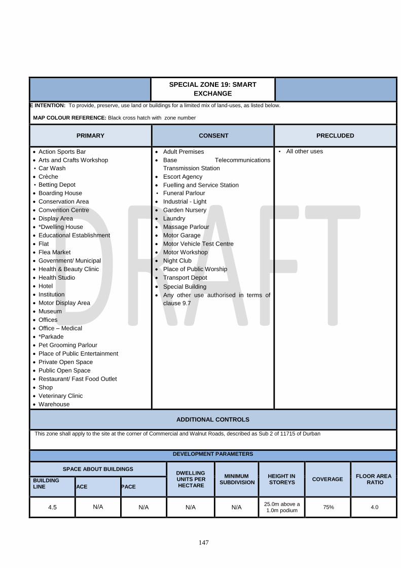
147
SPECIAL ZONE 19: SMART
EXCHANGE
SCHEME INTENTION: To provide, preserve, use land or buildings for a limited mix of land-uses, as listed below.
MAP COLOUR REFERENCE: Black cross hatch with zone number
PRIMARY
CONSENT PRECLUDED
Action Sports Bar
Arts and Crafts Workshop
• Car Wash
Crèche
• Betting Depot
Boarding House
Conservation Area
Convention Centre
Display Area
*Dwelling House
Educational Establishment
Flat
Flea Market
Government/ Municipal
Health & Beauty Clinic
Health Studio
Hotel
Institution
Motor Display Area
Museum
Offices
Office – Medical
*Parkade
Pet Grooming Parlour
Place of Public Entertainment
Private Open Space
Public Open Space
Restaurant/ Fast Food Outlet
Shop
Veterinary Clinic
Warehouse
Adult Premises
Base Telecommunications
Transmission Station
Escort Agency
Fuelling and Service Station
• Funeral Parlour
Industrial - Light
Garden Nursery
Laundry
Massage Parlour
Motor Garage
Motor Vehicle Test Centre
Motor Workshop
Night Club
Place of Public Worship
Transport Depot
Special Building
Any other use authorised in terms of
clause 9.7
• All other uses
ADDITIONAL CONTROLS
This zone shall apply to the site at the corner of Commercial and Walnut Roads, described as Sub 2 of 11715 of Durban
DEVELOPMENT PARAMETERS
SPACE ABOUT BUILDINGS DWELLING UNITS PER HECTARE
MINIMUM SUBDIVISION
HEIGHT IN STOREYS
COVERAGE FLOOR AREA
RATIO BUILDING LINE
SIDE SPACE REAR SPACE
4.5 N/A N/A N/A N/A 25.0m above a 1.0m podium 75% 4.0

148
SPECIAL ZONE 20: ANSTEY RD
SCHEME INTENTION: To provide, preserve of use land for higher density residential, including wide range of ancillary uses which serve
the day to day needs of a residential community
MAP COLOUR REFERENCE: Black Cross- hatch numbered MAP REFERENCE:
PRIMARY SPECIAL CONSENT PRECLUDED
• Boarding house
• Chalet Development
• Dwelling house
• Flat
• Hotel
• Launderette
• Multiple Unit Development
• Retirement center
Agricultural land
Base
telecommunications
transmission station
Crèche
Education establishment
Health and beauty clinic
Health Studio
Hotel
Parkade
Place of public worship
Special Building
Shop
All other uses
ADDITIONAL CONTROLS
1. The following shall apply to Rem of Lot 2074 and Sub 20 of Lot 2073 both of Wentworth.
(a) the development shall be restricted to a maximum of 63 units;
(b) the height of any building shall not exceed a maximum of three storeys;
(c) no portion of any building shall exceed a height of 3,5m above the centre line of Marine Drive;
(d) no portion of any building shall exceed a height of 12,5m above the centre-line of Anstey Road and Foreshore Drive;
(e) a right turn facility of at least 15m in length to accommodate 3 vehicles and a minimum taper of 1:2 shall be provided at the access
point on Anstey Road;
(f) the existing trees along Marine Drive and within the site shall be retained or replaced to the satisfaction of the Executive Director
(Physical Environment).
2. The following shall apply to Rem of Portion 3 of Erf 2076 Wentworth :-
b) The development shall be restricted to a maximum of 8 units.
c) The height of any building shall not exceed a maximum of three storeys.
d) No portion of any building shall exceed a height of 3,5m above the centre line of
Marine Drive.
e) The existing tree’s along Marine Drive and within the site shall be retained or replaced to the satisfaction of the Head: Development Planning,
Environment & Management.
f) The applicant shall comply by submitting an Environmental Impact Assessment (EIA).
DEVELOPMENT PARAMETERS
SPACE ABOUT BUILDINGS DWELLING UNITS PER HECTARE
MINIMUM SUBDIVISI
ON(m2) HEIGHT COVERAGE
FLOOR AREA BUILDING
LINE SIDE
SPACE REAR
SPACE
7.5m
3m or 1,2m/storey whichever the greater
5m or 1.2m per floor to a max of 15m
The maximum number of
dwelling units permissible on an Erf shall be determined by
dividing the permissible
floor area by 90
900m2 *3 storeys 50% 1.2

149
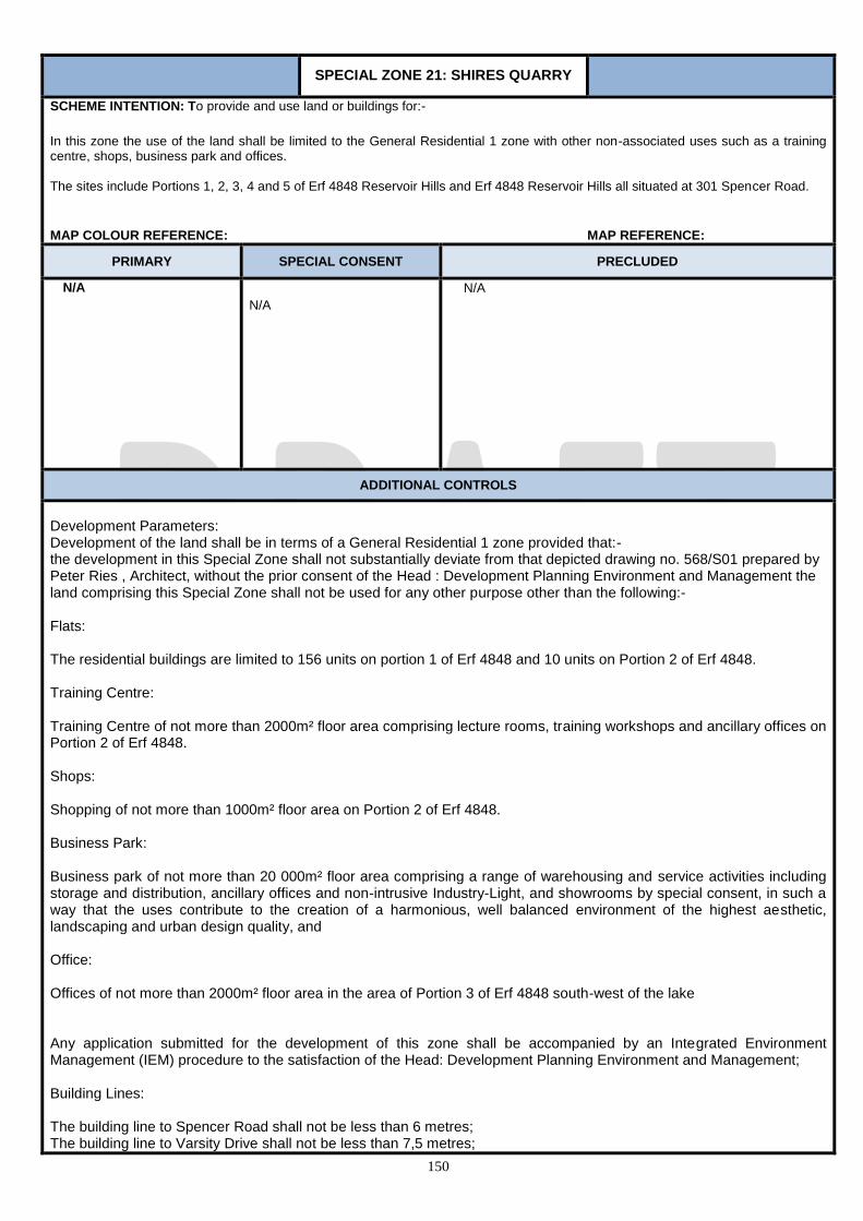
150
SPECIAL ZONE 21: SHIRES QUARRY
SCHEME INTENTION: To provide and use land or buildings for:-
In this zone the use of the land shall be limited to the General Residential 1 zone with other non-associated uses such as a training centre, shops, business park and offices. The sites include Portions 1, 2, 3, 4 and 5 of Erf 4848 Reservoir Hills and Erf 4848 Reservoir Hills all situated at 301 Spencer Road.
MAP COLOUR REFERENCE: MAP REFERENCE:
PRIMARY SPECIAL CONSENT PRECLUDED
N/A
N/A
N/A
ADDITIONAL CONTROLS
Development Parameters: Development of the land shall be in terms of a General Residential 1 zone provided that:- the development in this Special Zone shall not substantially deviate from that depicted drawing no. 568/S01 prepared by Peter Ries , Architect, without the prior consent of the Head : Development Planning Environment and Management the land comprising this Special Zone shall not be used for any other purpose other than the following:- Flats: The residential buildings are limited to 156 units on portion 1 of Erf 4848 and 10 units on Portion 2 of Erf 4848. Training Centre: Training Centre of not more than 2000m² floor area comprising lecture rooms, training workshops and ancillary offices on Portion 2 of Erf 4848. Shops: Shopping of not more than 1000m² floor area on Portion 2 of Erf 4848. Business Park: Business park of not more than 20 000m² floor area comprising a range of warehousing and service activities including storage and distribution, ancillary offices and non-intrusive Industry-Light, and showrooms by special consent, in such a way that the uses contribute to the creation of a harmonious, well balanced environment of the highest aesthetic, landscaping and urban design quality, and Office: Offices of not more than 2000m² floor area in the area of Portion 3 of Erf 4848 south-west of the lake Any application submitted for the development of this zone shall be accompanied by an Integrated Environment Management (IEM) procedure to the satisfaction of the Head: Development Planning Environment and Management; Building Lines: The building line to Spencer Road shall not be less than 6 metres; The building line to Varsity Drive shall not be less than 7,5 metres;
151
Side Spaces: There shall be a space free of all buildings of not less than 3 metres or a width calculated on the basis of 1,2 metres for the ground floor storey plus an additional 1,2 metres for each additional storey, whichever is the greater, on all boundaries of the site with the exception of the building lines mentioned above; The Municipality may, by Special Consent, relax the requirements above. Height: No building on Portion 1 shall exceed five storeys in height, no building on Portion 2 or Portion 3 shall exceed three storeys in height. Parking and Loading Requirements: On-site parking shall be provided for the residential development at a ratio of at least one parking bay per unit, for the shopping development at a ratio of five parking bays per 100m5 gross floor area, for the Training Centre at a ratio of one bay per 150m² gross floor area, for the Office and Business Park use at the ratio of 4 bays per 100m² for offices and 1 bay per 150m² for all other uses, to the satisfaction of the Head: Development Planning Environment and Management. Loading and off-loading facilities shall be provided to the satisfaction of the Head : Development Planning and Management; the uses referred to in condition above shall not be authorized if the following requirements have not been met to the satisfaction of the Head : Development Planning Environment and Management; At the development stage, the developer shall submit a Traffic Impact Assessment report to the Head: eThekwini Transport Authority and shall comply with the conditions of approval thereof; The total cost of the construction work resultant from the Traffic Impact Assessment shall be borne by the developer of this Special Zone, and shall be designed to the satisfaction of the Head : eThekwini Transport Authority and shall be submitted for consideration when the Municipality’s authority is sought to develop the land comprising this Special Zone; The existing access to Lot 22 to be accommodated.
DEVELOPMENT PARAMETERS
SPACE ABOUT BUILDINGS DWELLING UNITS PER HECTARE
MINIMUM SUBDIVISIO
N(m2) HEIGHT COVERAGE
FLOOR AREA RATIO BUILDING
LINE SIDE SPACE
REAR SPACE
40%
1.0 (Unless otherwise
stated)

152
SPECIAL ZONE 22: SUNCOAST
SCHEME INTENTION: To provide a range of uses and the potential development rights necessary to enable the site to be used as a
landmark Casino and resort complex on the beachfront.
MAP COLOUR REFERENCE: Black cross hatch with zone number MAP REFERENCE:
PRIMARY SPECIAL CONSENT PRECLUDED
• Action Sports Bar
• Arts and Crafts Workshop
• Beach Amenity Facility
• Betting Depot
• Conference Facility
• Casino*
• Flat
• Health and Beauty Clinic
• Health Studio
• Hotel
• Museum
• Night Club
• Office
• Office - Medical
• Parkade
• Place of Public Entertainment
• Restaurant / Fast Food Outlet
• Shop
• Base Telecommunications Transmission
station
• Place of Public Worship
• Special Building
All other uses.
ADDITIONAL CONTROLS
this special zone shall apply to the land depicted on Plan No. 1829.910 and the following conditions shall apply to any development of this special zone:- 1. Parking, Loading and off-loading facilities shall be provided in terms of Section 8. of this scheme. 2. Vehicular and pedestrian ingress and egress shall be provided to the satisfaction of the Head: Development Planning, Environment and Management. 3. The land comprising this Zone shall be landscaped to the satisfaction of the Head: Development Planning, Environment and Management. 4. *”Casino” shall mean usage as defined by the KwaZulu-Natal Gaming and Betting Act No. 8 of 2010, or any other subsequent replacement act.
DEVELOPMENT PARAMETERS
SPACE ABOUT BUILDINGS DWELLING UNITS PER HECTARE
MINIMUM SUBDIVISIO
N (m2)
HEIGHT IN STOREYS
COVERAGE FLOOR
AREA RATIO BUILDING LINE
SIDE AND REAR SPACE
To the satisfaction of the Head: Development Planning, Environment and Management.
Not to exceed 110m above mean
sea level
To the satisfaction of the Head: Development
Planning, Environment and Management
2.0

153
SPECIAL ZONE 23: BEREA ROAD
SCHEME INTENTION: To provide, preserve, use land or buildings for the Berea Road Special Zone area.
PRIMARY CONSENT PRECLUDED
Dwelling House
Flat
Institution
Office
Crèche
Industry-light
Conservation area
Educational establishment
Place of Public of Worship
Betting Depot
Restaurant / Fast Food outlet
Special Building
All other uses
ADDITIONAL CONTROLS
Special Zone No. 87 : Berea Road shall apply to the following properties:-
Rem of Portion 6 of Erf 5008 Durban Portion 7 (of 1) of Erf 5009 Durban Portion 6 (of 2) of Erf 5009 Durban Portion 3 of Erf 5010 Durban Portion 6 (of 2) of Erf 5010 Durban Portion 5 of Erf 5007 Durban Portion 2 of Erf 5006 Durban Portion 6 of Erf 5007 Durban Portion 3 of Erf 5006 Durban Portion 7 of Erf 5007 Durban Portion 4 of Erf 5006 Durban Erf 5005 Durban Erf 5004 Durban Portion 17 of Erf 5001 Durban Portion 50 of Erf 5001 Durban Portion 4 of Erf 5001 Durban Portion 3 of Erf 5001 Durban Rem of Portion 2 of Erf 5001 Durban
2. The building line and side and rear space requirements may be relaxed at the discretion of the Head Development Planning, environment
Management. 3. On-site parking for office use within this Special Zone shall be provided at a ratio of one space per 25m5 of floor area of the building being utilised
for such purpose with no provision for relaxation. Parking for any other use permitted within this Special Zone shall be to the satisfaction of the Head Development Planning, environment Management.
4. Loading and off-loading facilities shall be provided to the satisfaction of the EThekwini transport Authority. Ingress and egress arrangements shall
be to the satisfaction of the EThekwini transport Authority.
DEVELOPMENT PARAMETERS
SPACE ABOUT BUILDINGS
DWELLING UNITS PER HECTARE MINIMUM
SUBDIVISION HEIGHT
IN STOREYS COVERAGE
FLOOR AREA RATIO BUILDING
LINE SIDE SPACE REAR SPACE
7.5m 3m
The maximum number of dwelling units permissible on an Erf shall be
determined by dividing the permissible floor area by 90 (for Erf Control
900
N/A;
*Unless as indicated on the
Map
50%;
1.2

154
SPECIAL ZONE 24: POINT WATERFRONT
SCHEME INTENTION: To provide, preserve, use land or buildings to accommodate a wide range of recreational, entertainment,
residential, shopping, business, commercial, community, service industrial and related activities and any other activities that would
ordinarily be accommodated within a city environment, in such a way that the uses contribute towards the creation of a dynamic,
harmonious and well balanced city precinct of the highest aesthetic, landscaping and urban design quality that promotes the notion of
African urbanism.
The Vision for the development of the Point Waterfront is contained within the Development Framework Plan entitled “The Point-Durban,
Revised Development Framework Plan”, as amended and approved by the Head: Development Planning, Environment and
Management from time-to-time.
The vision is based on the following development principles:
a. The creation and promotion of an urban quality of life b. Ensuring the maintenance of a human scale c. The creation of a pedestrian friendly environment d. The creation of a legible urban environment e. The maintenance of a clean, well-managed and safe environment f. An emphasis on mixed-use developments g. The ability to provide for a Site / Block integration in an appropriate manner
The Design and Review Panel established by the Primary Developer in terms of the Zone must ensure that the above vision and principles and the intentions of the approved Development Framework Plan are met in all development proposals and recommendations.
MAP COLOUR REFERENCE: TBA MAP REFERENCE:
Glossary of Terms and Definitions
1.1 Unless where described below, or otherwise described/provided for in Section A or Section B above, the definitions of the Scheme will apply.
1.2 Primary Developer refers to the Durban Point Development Company as the entity entering into agreement with the Municipality and which is responsible for the administration, planning and detailed design of the POINT WATERFRONT and its development.
1.3 Local Authority refers to the eThekwini Municipality and is the competent authority under which the Primary Developer discharges its development undertakings, duties and responsibilities
1.4 Development Rights refers to bulk floor area and all development parameters ascribed to a Lot in terms of the Development Framework.
1.5 Lot Owners' Association (LOA) refers to the Association set up by the Primary Developer (in which the Primary Developer shall retain an ongoing interest) to which every lot owner and occupier shall belong, and by which Association's objectives and requirements such members shall be bound.
1.6 Design Review Panel refers to a body set up by the Primary Developer, to assess the plans required in terms of this zone and to assess all development proposals by secondary developers prior to the submission of Building Plans to the Local Authority for approval.
1.7 Permitted Floor Area Bank is a term referring to the pool of development rights (bulk floor area) which is allocated by the Primary Developer within the ambit defined by this zone.
1.8 Primary Floor Area Rights refers to the total approved bulk floor area rights which are available to the Primary Developer. 1.9 Scheme refers to the Durban Scheme. 1.10 Special Zone Area refers to the properties that are included within this Special Zone 24: Point Waterfront. 1.11 Storey(s): Means that part of a building which is situated between two floors, or if there is no floor above it, the underside of
the ceiling. Such storey shall not exceed 4.5m in height for residential and 5.5m in height for other uses, save that: i) Spaces provided for lifts, elevators and similar rooms or architectural features and which are in proportion to the building shall not constitute a storey or floor; ii) In the event of a storey being higher than the height as indicated above, it shall be counted as two storeys; iii) A mezzanine shall not count as a storey; iv) A basement shall not count as a storey; v) A roof which may contain or support any room shall count as a storey.
1.12 Floor Area Ratio refers directly to Plot Area Ratio as utilised within the Durban Scheme.

155
PRIMARY SPECIAL CONSENT PRECLUDED
• Action Sports Bar
• Arts and Craft Workshop
• Beach Amenity Facility
• Boarding House
• Boat Launching Site
• Harbor amenity facility
• Convention Centre
• Conference Facility
• Crèche
• Dive Charter
• Dwelling House
• Educational Establishment
• Flat
• Government and Municipal
• Health and Beauty Clinic
• Health studio
• Hotel
• Industry - Light
• Institution
• Laundry
• Museum
• Multiple Unit Development
• Office
• Office - Medical
• Parkade
• Place of Public
Entertainment
• Place of Public Worship
• Private Open Space
• Public Open Space
• Restaurant / Fast-food
Outlet
• Retirement Centre
• Shop
• Sports and Recreation
• Utilities Facility
• Base Telecommunications Transmission station
• Any other land use considered by the Head:
Development Planning, Environment, and
Management to be ancillary to the primary land use
•
ADDITIONAL CONTROLS
2. Land Use and Development
2.1 Side walk cafes shall be permitted within this Special Zone 2.2 Land use and Development within the Special Zone 21: Point Waterfront will be managed through a package of plans and a
maximum permitted development floor area. This approach is intended to achieve flexibility in the implementation of the scheme.
3. The Package Of Plans and Delegations will consist of: 3.1 A Development Framework Plan prepared by the Primary Developer and amended from time-to-time. 3.2 Precinct Plans for each of the precincts as identified in the Development Framework Plan, prepared by the Primary
Developer and amended from time-to-time. 3.3 Building Plans approved in terms of the National Building Regulations and/or relevant legislation. 3.4 The Development Framework Plan and Precinct Plans and any amendments thereto will be approved by, or in a manner
determined by, the Head: Development Planning Environment and Management.
4. Management of Development Rights – Maximum Permitted Floor Area Bank 4.1 The management of Development Rights is in terms of a "Permitted Floor Area Bank" and the vesting of all of the
Development Rights contained in the Permitted Floor Area Bank with the Primary Developer, through whom and by whom, within the provision of this Special Zone, all rights are allocated.
4.2 The maximum permitted development floor area within the boundary of Special Zone 21: Point Waterfront will be 750,000m2. 4.3 However, within this maximum, development will be limited to a maximum floor area of 650,000m2 until such time as an

156
additional link into the area has been implemented. 4.4 An amendment to increase the maximum permissible floor area of 750,000 m2 will require a scheme amendment in terms of
the relevant Planning Legislation. 4.5 The maximum Floor Area Rights include the rights that have been allocated to uShaka Marine World i.e. 40,000m2 for retail,
recreation, or entertainment or office purposes. Any additional Development Rights desired by uShaka must be acquired from the Primary Developer.
4.6 The total amount of Development Rights will be held in a "Permitted Floor Area Bank" which is effectively controlled and managed by the Primary Developer, in conjunction with the Local Authority.
4.7 The manner in which the Development Rights held in the Permitted Floor Area Bank will be sold / transferred / distributed and used shall be in accordance with the approved Development Framework Plan.
4.8 The Primary Developer shall be responsible for maintaining an accurate record of the "drawdown" of Rights from the Permitted Floor Area Bank. The Primary Developer must submit audited, quarterly reports on the status of Rights within the Permitted Floor Area Bank. The Local Authority may retain its own record as a reference.
4.9 Each building Plan Submitted to the Municipality must stipulate in the area schedule an accurate record of the current permissible Floor area as per the permitted floor area bank.
5. Sidewalk and Canal Servitudes 5.1 The sidewalks and canals within the POINT WATERFRONT may be owned by the Local Authority, but in line with the principles
on which the POINT WATERFRONT is developed, the Lot Owners Association, subject to separate written agreement with the Local Authority, will have a "User Right" over the sidewalks and canals through the mechanism of "Sidewalk" and "Canal" Servitudes or any other mechanism that may be agreed to by the Local Authority and with the relevant conditions that will be agreed to by the Local Authority.
5.2 The intention is to enable the sidewalks and canals to become places of vibrant activity and where the public and private realms 'blur" together. It is however essential that the activities, maintenance, cleansing and security if these spaces be carefully and thoroughly managed. These management tasks would be the responsibility of the LOA.
6. Design Review Panel and Development Manual 6.1 A Design Review Panel will be established by the Primary Developer and will be responsible for the review and assessment
of all development proposals by Secondary Developers in a manner to be determined by the Primary Developer. 6.2 The Local Authority will not approve any Building Plan of Secondary Developers unless it has been recommended for approval
by the Design Review Panel and provided that the relevant Precinct Plan has been approved by the Local Authority in the manner described in Section B.
6.3 The recommendation of Building Plans by the Design Review Panel shall only occur once the purchaser/site developer has adhered to all requirements of the zone and the Precinct Plans.
6.4 The composition, function and responsibilities will be detailed by the Primary Developer but must include Local Authority representation.
6.5 A Development Manual will be formulated by the Primary Developer for secondary developers which will guide developers in terms of the Point Waterfront's vision and principles, as well as, in terms of architectural requirements and controls. This will be concerned with "good practice" and the need to ensure that suitable, facilitative oriented documentation is available for investors and will be used together with the DFP and Precinct Plans to guide the Design and Review Panel in making recommendations on building plans prior to submission to the Local Authority for approval.
7. Consolidation and Sub-division 7.1 Nothing within the Scheme or this zone shall prohibit the consolidation and/or subdivision of blocks within the Development
Framework provided that the overall traffic network is not jeopardised
8. Floor Area Ratio 8.1 Floor Area is managed in terms of the Development Rights Bank as per clause 6. 8.2 Site by site floor area ratios may be suggested in the Precinct Plans as approved by the Head: Development Planning,
Environment & Management and amended from time-to-time and managed by the primary developer.
9. Land Use Distribution 9.1 The land use mix within the Special Zone Area will not be limited, however the mix of uses across the whole zone should
accord with the ratio used in the Transportation Study (Iliso June 2015), and shall be managed and recorded by the Primary Developer as part of the Development Rights Bank i.e. the maximum floor area of any use should be
Residential (including Holiday Homes) 63%
Office (including medical offices and financial institutions)16%
Retail (including restaurants and entertainment) 8%
Hotel (including all usual ancillary hotel uses) 13% 9.2 These figures may vary up or down by 20% without affecting the traffic distribution. Any further deviation (i.e. beyond 20%) is
subject to a revised Traffic Impact Assessment and approval by the Head ETA and the Head: Development Planning, Environment and Management.
10. Parking and Loading 10.1 Private parking will be provided on site for the residential and hotel uses and would generally not be available for use by others
even when the bay is not in use. 10.2 Public parking would normally be provided at on site public areas or offsite Parkades and are available for use by the general
public. Land uses for which this is applicable include offices, retail and entertainment. Some level of access control would be employed for these areas for commercial and/or security reasons.
10.3 The parking requirements 10.4 for any other use or activity that does not fall within the categories listed below shall be determined according to the Scheme
or as per the Head: Development Planning, Environment and Management if the Scheme does not provide for any specific type of activity.

157
10.5 Public parking will be provided and managed by the Local Authority on Lot 6.2 within a Parkade to be constructed, as well as on street and in a designated area/s under the promenade. This will include parking requirements for uShaka.
10.6 Acknowledging that the development of the Point Waterfront is based on a mix of land uses, a pedestrian friendly environment and promotes the use of public transport, parking shall be provided at the following ratios:
Land Use Exclusive Use Parking Ratios Shared Parking Ratios
1 or 2 Bedroom unit 1.5 bays per unit
3 Bedroom unit 1.75 bays per unit
4 Bedrooms and above 2 bays per unit
Entertainment* 5.95 bays per 100m2 GLA
Hotel 1.0 bay per room
Office 3.4 bays per 100m2 GLA
Retail 4.25 bays per 100m2 GLA
* Entertainment is defined as follows:-
Casino and related uses, i.e. restaurants, cinemas, night clubs and places of amusements, etc.
Place of Public Entertainment including games arcades, indoor go-carts, ten-pin bowling, snooker halls, etc.
Place of entertainment including, cinemas, theatres, etc.
Restaurants, mainly a La Carte, family restaurant chains but excluding fast food outlets.
10.7 To calculate the parking requirements for mixed use buildings follow the method below:
Determine the actual floor areas and unit numbers for each individual land use type within each mixed use area.
Apply the parking ratios in 14.5 above to all land uses.
Apply the time related percentage accumulation factors as per the table below to each of the shared land use types (entertainment, office, retail) for both weekend and weekday scenarios.
Sum the individual land-use parking bay numbers for each time period to establish the peak parking requirement for shared land uses.
Hour 0f Day
Office % Retail % Entertainment%
Weekday
Saturday
Weekday
Saturday
Weekday Saturday
06:00 3 - - - -2.51e+36 -
07:00 20 20 8 3 -
08:00 63 60 18 10 -
09:00 93 80 42 30 -
10:00 100 80 68 45 -
11:00 100 100 87 73 -
12:00 90 100 97 85 30
13:00 90 80 100 95 70
14:00 97 60 97 100 70
15:00 93 40 95 100 70
16:00 77 40 87 90 70
17:00 47 20 79 75 70
18:00 23 20 82 65 80
19:00 7 20 89 60 90
20:00 7 20 87 55 100
21:00 3 - 61 40 100
22:00 3 - 32 38 100
23:00 - - 13 13 80
24:00 - - - - 70
10.8 Loading shall be provided is accordance with the Durban Planning Scheme.
11. Calculating Floor Area 11.1 For the purposes of calculating the total permissible floor area in the Special Zone, the following shall be taken into account:- 11.2 All wall thicknesses, closed balconies, closed verandas, closed corridors and closed staircases shall be included. 11.3 Awnings, canopies, arbours, colonnades, balconies, within the sidewalk area shall not be included. 11.4 Any portion of the building which is below first floor level and which is shown on the plan as designed or intended as a covered
area for the deposit of daily refuse shall not be taken into account. 11.5 Parking areas (covered and uncovered) shall not be included in FAR and coverage calculations. 11.6 The floor area of all outbuildings shall be taken into account. 11.7 An uncovered swimming pool situated entirely in the open and a lift motor room, an electronic transformer and meter room and
a mechanical ventilation and air-conditioning plant room shall not be taken into account 11.8 Where the conveniences for use by the public are provided within a shopping complex, either as a separate building or as part
of a building where access thereto is from a shopping mall, arcade or the like or from a parking area or other open area accessible to the public, then the floor area of such conveniences shall not be taken into account when calculating the total permissible floor area.
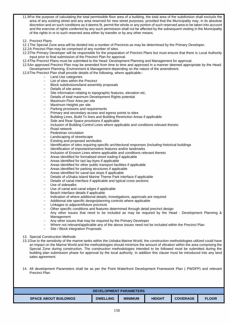
158
11.9 For the purpose of calculating the total permissible floor area of a building, the total area of the subdivision shall exclude the area of any existing street and any area reserved for new street purposes; provided that the Municipality may, in its absolute discretion and on such conditions as it deems fit, permit the whole or any portion of such reserved area to be taken into account and the exercise of rights conferred by any such permission shall not be affected by the subsequent vesting in the Municipality of the rights in or to such reserved area either by transfer or by any other means.
12. Precinct Plans 12.1 The Special Zone area will be divided into a number of Precincts as may be determined by the Primary Developer. 12.2 A Precinct Plan may be comprised of any number of sites. 12.3 The Primary Developer will be responsible for the preparation of Precinct Plans but must ensure that there is Local Authority
input prior to final submission of the Precinct Plan for approval. 12.4 The Precinct Plans must be submitted to the Head: Development Planning and Management for approval. 12.5 An approved Precinct Plan may be amended from time to time and approved in a manner deemed appropriate by the Head:
Development Planning, Environment & Management depending on the nature of the amendment. 12.6 The Precinct Plan shall provide details of the following, where applicable:-
Land Use categories List of sites within the Precinct Block subdivisions/land assembly proposals Details of site areas Site information relating to topographic features, elevation etc. Details of total maximum Development Rights potential Maximum Floor Area per site Maximum Heights per site Parking provisions and requirements Primary and secondary access and egress points to sites Building Lines, Build To lines and Building Restriction Areas if applicable Side and Rear Space provisions if applicable Inclusion of Building Control Lines where applicable and conditions relevant thereto Road network Pedestrian circulation Landscaping of streetscape Existing and proposed servitudes Identification of sites requiring specific architectural responses (including historical buildings Identification of important/sensitive features and/or landmarks Inclusion of Erosion Lines where applicable and conditions relevant thereto Areas identified for formalised street trading if applicable Areas identified for taxi lay-byes if applicable Areas identified for other public transport facilities if applicable Areas identified for parking structures if applicable Areas identified for canal taxi stops if applicable Details of uShaka Island Marine Theme Park interface if applicable Details of canal interface if applicable and typical cross sections Use of sidewalks Use of canal and canal edges if applicable Beach interface details if applicable Indication of where additional details, investigations, approvals are required Additional site specific design/planning controls where applicable Linkages to adjacent/future precincts Other specific conditions and features determined through detail precinct design Any other issues that need to be included as may be required by the Head : Development Planning &
Management Any other issues that may be required by the Primary Developer Where not relevant/applicable any of the above issues need not be included within the Precinct Plan Site / Block integration Proposals
13. Special Construction Methods 13.1 Due to the sensitivity of the marine tanks within the Ushaka Marine World, the construction methodologies utilized could have
an impact on the Marine World and the methodologies should minimize the amount of vibration within the area comprising the Special Zone during construction. The construction methodologies intended to be followed must be submitted during the building plan submission phase for approval by the local authority. In addition this clause must be introduced into any land sales agreement.
14. All development Parameters shall be as per the Point Waterfront Development Framework Plan ( PWDFP) and relevant
Precinct Plan
DEVELOPMENT PARAMETERS
SPACE ABOUT BUILDINGS DWELLING MINIMUM HEIGHT COVERAGE FLOOR
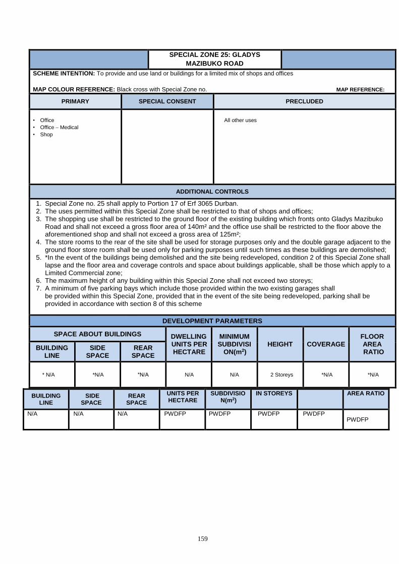
159
BUILDING LINE
SIDE SPACE
REAR SPACE
UNITS PER HECTARE
SUBDIVISION(m2)
IN STOREYS AREA RATIO
N/A N/A N/A PWDFP PWDFP PWDFP PWDFP PWDFP
SPECIAL ZONE 25: GLADYS
MAZIBUKO ROAD
SCHEME INTENTION: To provide and use land or buildings for a limited mix of shops and offices
MAP COLOUR REFERENCE: Black cross with Special Zone no. MAP REFERENCE:
PRIMARY SPECIAL CONSENT PRECLUDED
• Office
• Office – Medical
• Shop
All other uses
ADDITIONAL CONTROLS
1. Special Zone no. 25 shall apply to Portion 17 of Erf 3065 Durban. 2. The uses permitted within this Special Zone shall be restricted to that of shops and offices; 3. The shopping use shall be restricted to the ground floor of the existing building which fronts onto Gladys Mazibuko
Road and shall not exceed a gross floor area of 140m² and the office use shall be restricted to the floor above the aforementioned shop and shall not exceed a gross area of 125m²;
4. The store rooms to the rear of the site shall be used for storage purposes only and the double garage adjacent to the ground floor store room shall be used only for parking purposes until such times as these buildings are demolished;
5. *In the event of the buildings being demolished and the site being redeveloped, condition 2 of this Special Zone shall lapse and the floor area and coverage controls and space about buildings applicable, shall be those which apply to a Limited Commercial zone;
6. The maximum height of any building within this Special Zone shall not exceed two storeys; 7. A minimum of five parking bays which include those provided within the two existing garages shall
be provided within this Special Zone, provided that in the event of the site being redeveloped, parking shall be provided in accordance with section 8 of this scheme
DEVELOPMENT PARAMETERS
SPACE ABOUT BUILDINGS DWELLING UNITS PER HECTARE
MINIMUM SUBDIVISI
ON(m2) HEIGHT COVERAGE
FLOOR AREA RATIO
BUILDING LINE
SIDE SPACE
REAR SPACE
* N/A *N/A *N/A N/A N/A 2 Storeys *N/A *N/A

160

161
SPECIAL ZONE 26: BROADWAY PRECINCT
SCHEME INTENTION: To provide, preserve, use land or buildings for a limited mix of land-uses, as listed below. The purpose of this zone is to
promote and manage residential, business and office uses in close proximity to or integrated with each other within the Broadway Precinct to
reinforce its status as a neighbourhood shopping and convenience node.
MAP COLOUR REFERENCE: Black cross hatch with zone number MAP REFERENCE:
1. This special zone shall apply to the following properties:- Erven 1791-1798, 1826-1827, 1830-1831, 1834-1845, 1848-1849,1879-1904, 1917-1926, 1929-1943, 1973, 1976-1991, 1994-1995, 1998, 2020-2021, 2023-2028, 2030-2031, all of Durban North.
2. The Broadway Precinct drawing hereunder forms an integral component of the Zone and indicates the broad land use treatment thereof. This special zone comprises 3 land use components, i.e. Commercial, Residential Office Conversion and Redevelopment, Residential Office Conservation.
2.1 Land Use Component 1: Commercial Erven : 1793, 1884-1885, 1887-1896, 1898-1899, 1922-1923, 1926, 1929-1937 and 1939, all of Durban North. Intention : A retail and office area which may comprise a mix of residential, retail, offices, restaurants and by Special Consent entertainment
uses.
PRIMARY SPECIAL CONSENT PRECLUDED
*Flat
*Shops
Car Wash
Health & Beauty Clinic
Health Studio
Office
Office - Medical
Pet Grooming Parlour
Restaurant/ Fast Food
Outlet
Action Sports Bar
Base Telecommunications
Transmission Station
Place of Public Entertainment
Education Establishment
• Fuelling and Service Station
Flea Market
Night Club
Special Building
Any other use authorised in
terms of Section 9.4
• All other uses
ADDITIONAL CONTROLS
1. *The controls in accordance with that applicable to a Limited Commercial Zone shall apply. 2. A three storey height may be permitted on a sloping site by Special Consent 3. The Commercial Component of Erf 1793 Durban North will be limited to a maximum 140m² retail floor space and 600m²
storage/warehouse
DEVELOPMENT PARAMETERS
SPACE ABOUT BUILDINGS DWELLING UNITS PER HECTARE
MINIMUM SUBDIVISION(
m2)
HEIGHT IN STOREYS
COVERAGE FLOOR AREA BUILDING
LINE SIDE AND
REAR SPACE
3.0m Nil N/A 450 2 50% N/A
3.2 Land Use Component 2 : Residential Office Conversion and Redevelopment Erven : 1794,1834, 1835, 1839 to1841, 1881, 1886, 1897, 1902, 1919, 1925, 1938, 1940, 1980 to 1982, 1986 and 1987, 2026 all of Durban
North. . Intention: A residential area where offices may be permitted through the conversion of existing buildings or through redevelopment provided that neighbourhood amenity is not materially impacted on.
PRIMARY SPECIAL CONSENT PRECLUDED
• Dwelling House
• Multiple Unit Development
• Office
• Office - Medical
• Base Telecommunications Transmission Station
• Crèche
• Health & Beauty Clinic
• Educational Establishment
• Institution
• Place of Public Worship
• Special Building
All other uses

162
ADDITIONAL CONTROLS
3.2.1 Floor Area Ratio: where a dwelling unit is to be converted or redeveloped for suburban office purposes, then the floor area ratio for office
purposes shall not exceed 0.5 to 1. 3.2.2 On sloping ground, 3 storeys shall be permitted, provided that such building at no point exceeds more than 2 storeys in a vertical line. 3.2.3 Signage, Hoarding and Advertising shall be in accordance with sub-section 1.20 of this scheme. 3.2.4 Parking shall be provided on-site at the ratio of one bay per 25m2 of offices and in the case of any other use, parking shall be provided in
terms of section 8. of this scheme. Such parking shall be screened and constructed of pervious material to the satisfaction of the Head:
EThekwini traffic authority. 3.2.5 All properties converted or redeveloped for office use within this component shall be landscaped to the satisfaction of the Municipality.
DEVELOPMENT PARAMETERS
SPACE ABOUT BUILDINGS DWELLING UNITS PER HECTARE
MINIMUM SUBDIVISION(
m2)
HEIGHT IN STOREYS
COVERAGE FLOOR AREA BUILDING
LINE SIDE SPACE
REAR SPACE
7.5m 2m One dwelling
house for every 900m2
900 2
(see 3.2.2 above)
40% 0.8
(see 3.2.1 above)
3.3 Land Use Component 3: Residential Office Conservation
Erven : 1791, 1792,1795 to 1798, 1826, 1827, 1830, 1831, 1836 to1838, 1842 to 1845, 1848, 1849,1879, 1880, 1882, 1883, 1900, 1901,
1903, 1904, 1917, 1918, 1920, 1921, 1924, 1941 to 1943, 1973, 1976 to 1979, 1983 to 1985, 1988 to 1991, 1994, 1995, 1998, 2020, 2021, 2023 to 2028, 2030 and 2031.
Intention: A residential area where non-intrusive offices may, in addition, be permitted through the conservation and conversion of existing buildings
whilst still protecting the neighbourhood amenity.
PRIMARY SPECIAL CONSENT PRECLUDED
Dwelling House
Multiple Unit Development
Office
Office - Medical
• Base Telecommunications Transmission Station • Health & Beauty Clinic • Educational Establishment • Institution • Place of Public Worship • Special Building
• All other uses
ADDITIONAL CONTROLS
1.3.1 Floor Area Ratio: where a dwelling unit is to be converted for suburban office purposes, then the floor area ratio for office purposes shall not exceed 0.3 to 1.
1.3.2 Signage, Hoarding and Advertising shall be in accordance with sub-section 1.20 of this scheme.
1.3.3 The Municipality may authorise on a sloping site the erection of a building which is more than 3 storeys in height if such building will at no
point have more than 2 storeys in a vertical line or the erection of a building which is 3 storeys in height. 1.3.4 Parking shall be provided on-site at the ratio of one bay per 25m2 of offices and in the case of any other use, parking shall be provided in
terms of section 8. of this scheme. The parking shall be screened and constructed of pervious material to the satisfaction of the duly
authorised official of the Municipality. 3.3.6 In the case of any alteration or renovation of any residential dwelling and/or ancillary outbuilding within this component, such alteration and/or
renovation shall retain the appearance of a residential dwelling to the satisfaction of the Head: Development Planning, Environment and
Management.
DEVELOPMENT PARAMETERS
SPACE ABOUT BUILDINGS DWELLING UNITS PER HECTARE
MINIMUM SUBDIVISION
(m2)
HEIGHT IN STOREYS
COVERAGE FLOOR AREA BUILDING
LINE SIDE SPACE
REAR SPACE
7.5m 2M One dwelling
house for every 900m2
900m2 2;
(see 3.3.3) 40%
0.8 (see 3.2.1 in
additional controls)

163
Fig. 3 – Broadway Precinct
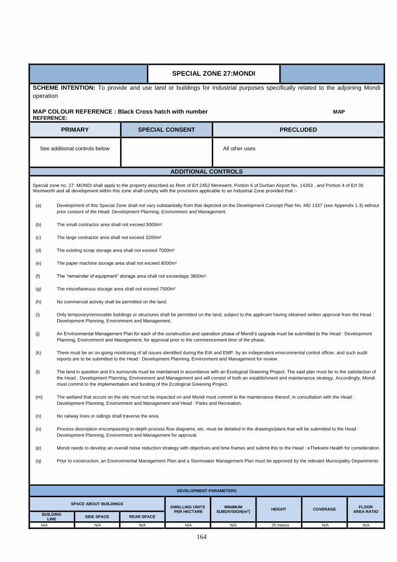
164
SPECIAL ZONE 27:MONDI
SCHEME INTENTION: To provide and use land or buildings for Industrial purposes specifically related to the adjoining Mondi
operation
MAP COLOUR REFERENCE : Black Cross hatch with number MAP REFERENCE:
PRIMARY SPECIAL CONSENT PRECLUDED
See additional controls below
All other uses
ADDITIONAL CONTROLS
Special zone no. 27: MONDI shall apply to the property described as Rem of Erf 2452 Merewent, Portion 6 of Durban Airport No. 14263 , and Portion 4 of Erf 35 Wentworth and all development within this zone shall comply with the provisions applicable to an Industrial Zone provided that :-
(a) Development of this Special Zone shall not vary substantially from that depicted on the Development Concept Plan No. MD 1337 (see Appendix 1.3) without
prior consent of the Head: Development Planning, Environment and Management.
(b) The small contractor area shall not exceed 5000m².
(c) The large contractor area shall not exceed 3200m²
(d) The existing scrap storage area shall not exceed 7000m²
(e) The paper machine storage area shall not exceed 8000m²
(f) The “remainder of equipment” storage area shall not exceedapp 3800m².
(g) The miscellaneous storage area shall not exceed 7500m²
(h) No commercial activity shall be permitted on the land.
(i) Only temporary/removable buildings or structures shall be permitted on the land, subject to the applicant having obtained written approval from the Head :
Development Planning, Environment and Management.
(j) An Environmental Management Plan for each of the construction and operation phase of Mondi’s upgrade must be submitted to the Head : Development
Planning, Environment and Management, for approval prior to the commencement time of the phase.
(k) There must be an on-going monitoring of all issues identified during the EIA and EMP, by an independent environmental control officer, and such audit
reports are to be submitted to the Head : Development Planning, Environment and Management for review.
(l) The land in question and it’s surrounds must be maintained in accordance with an Ecological Greening Project. The said plan must be to the satisfaction of
the Head : Development Planning, Environment and Management and will consist of both an establishment and maintenance strategy. Accordingly, Mondi
must commit to the implementation and funding of the Ecological Greening Project.
(m) The wetland that occurs on the site must not be impacted on and Mondi must commit to the maintenance thereof, in consultation with the Head :
Development Planning, Environment and Management and Head : Parks and Recreation.
(n) No railway lines or sidings shall traverse the area.
(o) Process description encompassing in-depth process flow diagrams, etc. must be detailed in the drawings/plans that will be submitted to the Head :
Development Planning, Environment and Management for approval.
(p) Mondi needs to develop an overall noise reduction strategy with objectives and time frames and submit this to the Head : eThekwini Health for consideration.
(q) Prior to construction, an Environmental Management Plan and a Stormwater Management Plan must be approved by the relevant Municipality Departments
DEVELOPMENT PARAMETERS
SPACE ABOUT BUILDINGS DWELLING UNITS
PER HECTARE MINIMUM
SUBDIVISION(m2) HEIGHT COVERAGE
FLOOR AREA RATIO
BUILDING LINE
SIDE SPACE REAR SPACE
N/A N/A N/A N/A N/A 25 metres N/A N/A.

165
SPECIAL ZONE 28: IRPTN MIXED USE
RESIDENTIAL
SCHEME INTENTION: To provide and use land or buildings for a mix of Residential, office and shops, in close proximity to Transportation corridors, in order to service the needs of a community MAP COLOUR REFERENCE: to be determined MAP REFERENCE:
PRIMARY SPECIAL CONSENT PRECLUDED
Dwelling house Flat Multiple Unit Development Office Office – Medical Private Open Space Restaurant/Fast Food Outlet
Hotel Educational Establishment Parkade Worship, Institution, Crèche, Fuelling and Service Station Special Building
All other uses
ADDITIONAL CONTROLS
Parking Provision : 1) Offices 2.5 bays/100m² of useable building area 2) Retail, restaurant, and similar commercial uses 2.5 bays/100m² of useable building area 3) Government & Municipal, Offices, Institutional 1.0 bays/100m² 4) Residential 1.0bays/100m² 5) All other uses shall be to the satisfaction of the Municipality Application may be made to the Municipality to reduce the total number of parking bays for any use subject to the applicant providing a suitable motivation for such reduction based on certain factors including, but not limited to; target market of potential users/ buyers, availability of on-street parking bays adjacent to the site, availability of any public bays in any central parking pool that may be reasonably accessible to the site and relevant precedent subject to the satisfaction of the eThekwini Transport Authority.
DEVELOPMENT PARAMETERS
SPACE ABOUT BUILDINGS DWELLING UNITS PER HECTARE
MINIMUM SUBDIVISION(m2)
HEIGHT COVERAGE FLOOR AREA RATIO
BUILDING LINE
SIDE SPACE
REAR SPACE
N/A N/A N/A N/A 900m² 12 Storeys N/A 3,5
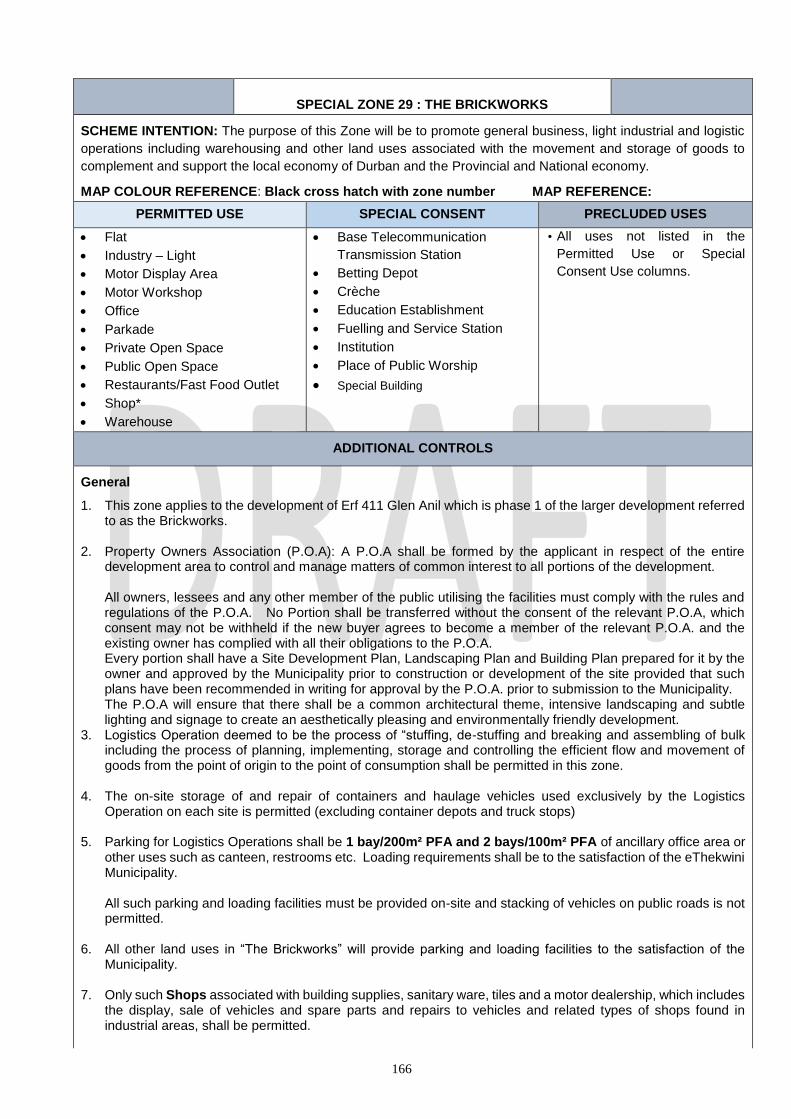
166
SPECIAL ZONE 29 : THE BRICKWORKS
SCHEME INTENTION: The purpose of this Zone will be to promote general business, light industrial and logistic
operations including warehousing and other land uses associated with the movement and storage of goods to
complement and support the local economy of Durban and the Provincial and National economy.
MAP COLOUR REFERENCE: Black cross hatch with zone number MAP REFERENCE:
PERMITTED USE SPECIAL CONSENT PRECLUDED USES
Flat
Industry – Light
Motor Display Area
Motor Workshop
Office
Parkade
Private Open Space
Public Open Space
Restaurants/Fast Food Outlet
Shop*
Warehouse
Base Telecommunication
Transmission Station
Betting Depot
Crèche
Education Establishment
Fuelling and Service Station
Institution
Place of Public Worship
Special Building
• All uses not listed in the
Permitted Use or Special
Consent Use columns.
ADDITIONAL CONTROLS
General
1. This zone applies to the development of Erf 411 Glen Anil which is phase 1 of the larger development referred to as the Brickworks.
2. Property Owners Association (P.O.A): A P.O.A shall be formed by the applicant in respect of the entire development area to control and manage matters of common interest to all portions of the development.
All owners, lessees and any other member of the public utilising the facilities must comply with the rules and regulations of the P.O.A. No Portion shall be transferred without the consent of the relevant P.O.A, which consent may not be withheld if the new buyer agrees to become a member of the relevant P.O.A. and the existing owner has complied with all their obligations to the P.O.A. Every portion shall have a Site Development Plan, Landscaping Plan and Building Plan prepared for it by the owner and approved by the Municipality prior to construction or development of the site provided that such plans have been recommended in writing for approval by the P.O.A. prior to submission to the Municipality. The P.O.A will ensure that there shall be a common architectural theme, intensive landscaping and subtle lighting and signage to create an aesthetically pleasing and environmentally friendly development.
3. Logistics Operation deemed to be the process of “stuffing, de-stuffing and breaking and assembling of bulk including the process of planning, implementing, storage and controlling the efficient flow and movement of goods from the point of origin to the point of consumption shall be permitted in this zone.
4. The on-site storage of and repair of containers and haulage vehicles used exclusively by the Logistics Operation on each site is permitted (excluding container depots and truck stops)
5. Parking for Logistics Operations shall be 1 bay/200m² PFA and 2 bays/100m² PFA of ancillary office area or
other uses such as canteen, restrooms etc. Loading requirements shall be to the satisfaction of the eThekwini Municipality.
All such parking and loading facilities must be provided on-site and stacking of vehicles on public roads is not permitted.
6. All other land uses in “The Brickworks” will provide parking and loading facilities to the satisfaction of the
Municipality.
7. Only such Shops associated with building supplies, sanitary ware, tiles and a motor dealership, which includes the display, sale of vehicles and spare parts and repairs to vehicles and related types of shops found in industrial areas, shall be permitted.

167
8. The total PFA shall not exceed 185 000m² (based on an average FAR of 0.6 of the net developable area of each site). The P.O.A. shall maintain a record of the PFA proposal on all buildings recommended by it for approval by the Municipality which cumulative record of the approved PFA must be submitted together with each building plan recommended for approval by the P.O.A. to enable the Municipality to ensure that not more than 185 000m² PFA is approved. No individual site shall exceed a FAR of 1.2.
9. PFA of 185 000m² shall not be exceeded without the P.O.A. first having gained the approval of the Municipality
with such approval being at the discretion of the Municipality.
10. *Flat shall be limited to one caretakers flat or unit on each portion.
11. Development shall not deviate from plan no. 1618/WD7 dated 05 June 2017 without the approval of the Municipality.
12. All aspects of the Environmental Authorisation ref. 1618/WD7 dated 05 June 2017 and any subsequent
amendments and the Environmental Management Plan shall be adhered to
DEVELOPMENT PARAMETERS
SPACE ABOUT BUILDINGS DWELLING
UNITS PER
HECTARE
MINIMUM
SUBDIVISION
HEIGHT IN
STOREYS
COVERAGE FLOOR
AREA
RATIO BUILDING
LINE
SIDE & REAR
SPACE
5.0m 5m Not
applicable 1800m² 6m N/A N/A
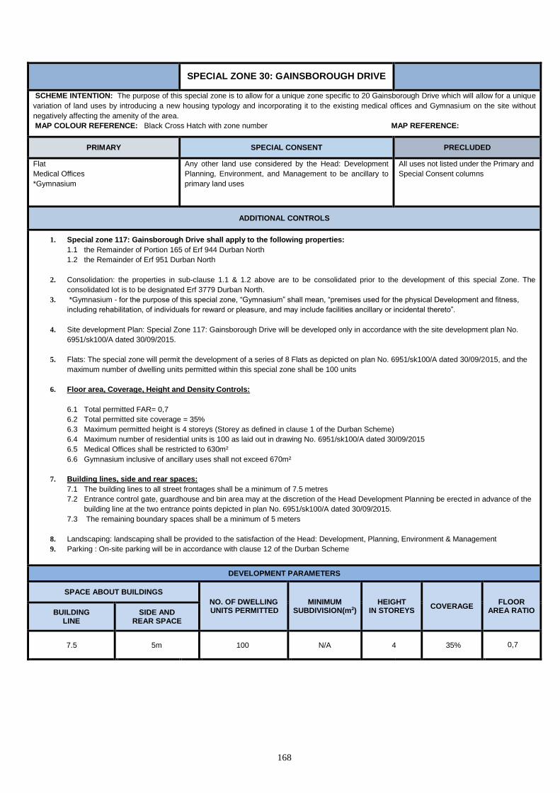
168
SPECIAL ZONE 30: GAINSBOROUGH DRIVE
SCHEME INTENTION: The purpose of this special zone is to allow for a unique zone specific to 20 Gainsborough Drive which will allow for a unique
variation of land uses by introducing a new housing typology and incorporating it to the existing medical offices and Gymnasium on the site without
negatively affecting the amenity of the area.
MAP COLOUR REFERENCE: Black Cross Hatch with zone number MAP REFERENCE:
PRIMARY SPECIAL CONSENT PRECLUDED
Flat
Medical Offices
*Gymnasium
Any other land use considered by the Head: Development
Planning, Environment, and Management to be ancillary to
primary land uses
All uses not listed under the Primary and
Special Consent columns
ADDITIONAL CONTROLS
1. Special zone 117: Gainsborough Drive shall apply to the following properties:
1.1 the Remainder of Portion 165 of Erf 944 Durban North
1.2 the Remainder of Erf 951 Durban North
2. Consolidation: the properties in sub-clause 1.1 & 1.2 above are to be consolidated prior to the development of this special Zone. The
consolidated lot is to be designated Erf 3779 Durban North.
3. *Gymnasium - for the purpose of this special zone, “Gymnasium” shall mean, “premises used for the physical Development and fitness,
including rehabilitation, of individuals for reward or pleasure, and may include facilities ancillary or incidental thereto”.
4. Site development Plan: Special Zone 117: Gainsborough Drive will be developed only in accordance with the site development plan No.
6951/sk100/A dated 30/09/2015.
5. Flats: The special zone will permit the development of a series of 8 Flats as depicted on plan No. 6951/sk100/A dated 30/09/2015, and the
maximum number of dwelling units permitted within this special zone shall be 100 units
6. Floor area, Coverage, Height and Density Controls:
6.1 Total permitted FAR= 0,7
6.2 Total permitted site coverage = 35%
6.3 Maximum permitted height is 4 storeys (Storey as defined in clause 1 of the Durban Scheme)
6.4 Maximum number of residential units is 100 as laid out in drawing No. 6951/sk100/A dated 30/09/2015
6.5 Medical Offices shall be restricted to 630m²
6.6 Gymnasium inclusive of ancillary uses shall not exceed 670m²
7. Building lines, side and rear spaces:
7.1 The building lines to all street frontages shall be a minimum of 7.5 metres
7.2 Entrance control gate, guardhouse and bin area may at the discretion of the Head Development Planning be erected in advance of the
building line at the two entrance points depicted in plan No. 6951/sk100/A dated 30/09/2015.
7.3 The remaining boundary spaces shall be a minimum of 5 meters
8. Landscaping: landscaping shall be provided to the satisfaction of the Head: Development, Planning, Environment & Management
9. Parking : On-site parking will be in accordance with clause 12 of the Durban Scheme
DEVELOPMENT PARAMETERS
SPACE ABOUT BUILDINGS
NO. OF DWELLING UNITS PERMITTED
MINIMUM SUBDIVISION(m2)
HEIGHT IN STOREYS
COVERAGE FLOOR
AREA RATIO BUILDING LINE
SIDE AND REAR SPACE
7.5 5m 100 N/A 4 35% 0,7
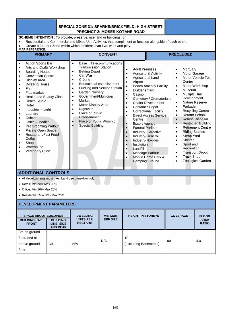
169
SPECIAL ZONE 31: SPARKS/BRICKFIELD: HIGH STREET
PRECINCT 2: MOSES KOTANE ROAD
SCHEME INTENTION : To provide, preserve, use land or buildings for:
Residential and Commercial and Mixed Use Activities that compliment or function alongside of each other.
Create a 24 hour Zone within which residents can live, work and play. MAP REFERENCE:
PRIMARY CONSENT PRECLUDED
Action Sports Bar
Arts and Crafts Workshop
Boarding House
Convention Centre
Display Area
Dwelling House
Flat
Flea market
Health and Beauty Clinic
Health Studio
Hotel
Industrial – Light
Laundry
Offices
Office – Medical
Pet Grooming Parlour
Private Open Space
Restaurant/Fast Food Outlet
Shop
Warehouse
Veterinary Clinic
Base Telecommunications Transmission Station
Betting Depot • Car Wash
Crèche
Educational establishment
Fuelling and Service Station
Garden Nursery
Government/Municipal
Market
Motor Display Area
Nightclub
Place of Public Entertainment
Place of Public Worship
Special Building
Adult Premises
Agricultural Activity
Agricultural Land
Airport
Beach Amenity Facility
Builder’s Yard
Casino
Cemetery / Crematorium
Chalet Development
Container Depot
Correctional Facility
Direct Access Service Centre
Escort Agency
Funeral Parlour
Industry-Extractive
Industry-General
Industry-Noxious
Institution
Landfill
Massage Parlour
Mobile Home Park & Camping Ground
Mortuary
Motor Garage
Motor Vehicle Test Centre
Motor Workshop
Museum
Multiple Unit Development
Nature Reserve
Parkade
Recycling Centre
Reform School
Refuse Disposal
Restricted Building
Retirement Centre
Riding Stables
Scrap Yard
Shelter
Sport and Recreation
Transport Depot
Truck Shop
Zoological Garden
ADDITIONAL CONTROLS All developments must meet Land use breakdown of;
Retail: Min 20% Max 30%
Office: Min 10% Max 20%
Residential: Min 50% Max 70%
DEVELOPMENT PARAMETERS
SPACE ABOUT BUILDINGS DWELLING UNITS PER HECTARE
MINIMUM ERF SIZE
HEIGHT IN STOREYS COVERAGE FLOOR AREA RATIO
BUILDING LINE: FRONT
BUILDING LINE: SIDE AND REAR
3m on ground
floor/ and nil
above ground
floor
NIL
N/A N/A
10
(excluding Basements) 80 4.0

170
SPECIAL ZONE 32: FILM STUDIOS, ANCILLARY ACTIVITIES
AND RELATED BUSINESS
SCHEME INTENTION: The purpose of this zone is to establish an international standard, mixed use, landmark development anchored by the Durban Film Studios and consisting of a wide range of uses related to the film industry, together with recreational, entertainment, residential, shopping, and commercial and other related activities. The intention is also to create a key tourism destination which accords with the strategic planning of the Municipality, especially for tourism and recreation purposes. The zone provides \for a variety of uses consisting primarily of film studios and film related uses, hotel, entertainment, residential, restaurant, educational, office and retail uses as well as arts and crafts and commercial workshops. MAP REFERENCE:
PRIMARY CONSENT PRECLUDED
Action Sports Bar
Arts and Crafts Workshop
Botanical Garden
Convention Centre
Conservation area
Display Area
Dwelling House
Educational Establishment
Exhibition Centre
Film Studio
Flat
Flea Market
Health & Beauty Clinic
Hotel
Market
Multiple Unit Development
Museum
Nature based tourism
Night Club
Office
Office – Medical
Parkade
Place of Public Entertainment
Public Open space
Private Open Space
Restaurant / Fast Food Outlet
Shop
Sports Academy
Sports and Recreation
Betting Depot
BTTS(Base Telecommunications Transmission Station)
Crèche
Car Wash
Environmental Conservation reserve
Fuelling and Service Station
Garden Nursery
Government/Municipal
Health Studio
Industry - Service
Institution
Laundry
Motor Display Area
Motor Workshop
Pet Grooming Parlour
Place of Public Worship
Retirement Centre
Special Building
Zoological Garden
Adult Premises
Agricultural Activity
Agricultural Land
Airport
Boarding House
Builder’s Yard
Direct Access Service Centre
Container Depot
Caravan Park
Cemetery/Crematorium
Chalet Development
Correctional Facility
Escort Agency
Funeral Parlour
Harbour Amenity Facility
Industry – Extractive
Industry – General
Industry - Light
Industry – Noxious
Landfill
Mobile Home Park & Camping Ground
Mortuary
Motor Vehicle Test Centre
Motor Garage
Nature Reserve
Recycling Centre
Reform School
Refuse Disposal
Riding Stables
Sand-winning
Scrap Yard
Storage Warehouse
Transport Depot
Truck Stop
Utilities Facility
Veterinary Clinic
Warehouse
ADDITIONAL CONTROLS
Prior to the preparation of any Site Development Plans within this zone, a Site Framework Plan is to be prepared and submitted for the approval of the Head: Development Planning and Environmental Management .showing the intended distribution of uses and development rights across the full extent of the zone. The Site Framework Plan shall also indicate the intended positioning of proposed ingress and egress points, connection points with the external environment including to neighbouring sites and public transport systems to address integration, the arrangement of parking as well as the proposed vehicular and pedestrian internal circulation routes across the zone. The site Framework Plan is intended to provide the context within which a Site Development Plan will be considered.
Prior to the development of any site making up the special zone, a Site Development Plan setting out the full details of the phasing, uses, bulk, height, coverage, access, ingress, internal circulation, parking and landscaping on that site is to be submitted for the approval of the Head : Development Planning and Environmental Management. Site Development Plans may be amended further on application to the Municipality for approval by the Head: Development Planning and Environmental Management.
The total floor area for the development within the Special Zone shall not exceed 665 000 m².
The applicant is to keep a detailed account of the use of floor area and other development rights across the Special Zone and no building plan shall be approved unless it is submitted with a full accounting of the distribution of the allowable Floor Area and other rights within the Special Zone and its various precincts to the satisfaction of the Head: Development Planning and Environmental Management.
The provision and distribution of parking is to be to the satisfaction; of the Head: Development Planning and Environmental Management, with detailed parking arrangements forming part of the Site Development Plans for each property within the zone.
DEVELOPMENT PARAMETERS
SPACE ABOUT BUILDINGS DWELLING UNITS PER HECTARE
MINIMUM ERF SIZE
HEIGHT IN STOREYS COVERAGE FLOOR AREA RATIO
BUILDING LINE: FRONT
BUILDING LINE: SIDE AND REAR

171
7.5m N/A N/A N/A 55
75% N/A
SPECIAL ZONE 33: UMLAZI STATION
SCHEME INTENTION: The purpose of this zone is to establish a mixed use zone, together with recreational, entertainment, residential, shopping, and commercial and other related activities. MAP REFERENCE:
PRIMARY CONSENT PRECLUDED
Action Sports Bar
Arts and Crafts Workshop
Betting Depot
Car Wash
Convention Centre
Conservation area
Display Area
Dwelling House
Educational Establishment
Flat
Flea Market
Health & Beauty Clinic
Hotel
Institution
Market
Multiple Unit Development
Museum
Office
Office – Medical
Parkade
Place of Public Entertainment
Public Open space
Private Open Space
Restaurant / Fast Food Outlet
Shop
Sports Academy
Sports and Recreation
Transport Depot
Utilities Facility
Base Telecommunications Transmission Station
Crèche
Fuelling and Service Station
Garden Nursery
Government/Municipal
Place of Public Worship
Retirement Centre
Special Building
All uses not listed under the Primary and
Special Consent columns
Development Controls:
Height:
5 storeys
FAR:
1
Coverage
50 %
Building Line
7.5 m
Parking
Commercial (office and retail): 4 bays / 100 m²
Mixed Use: Parking and Loading to the satisfaction of the Municipality.
Residential: 1 bay per Dwelling Unit
Special Zone: Parking and Loading to the satisfaction of the Municipality.

172
SPECIAL ZONE 34: KWAMNYANDU
SCHEME INTENTION: The purpose of this zone is to establish a mixed use zone, together with recreational, entertainment, residential, shopping, and commercial and other related activities. MAP REFERENCE:
1. Development Aims
The key aims of the KwaMnyandu Nodal Development are to:
i. Transform the apartheid created dysfunctional environment into a vibrant one with balanced distribution of social and economic opportunities.
ii. Create convenience and opportunity. iii. Move away from the stand-alone single-use commercial developments that are developed in isolation from the broader residential,
recreational and social needs of local communities
2. Development Principles
The key principles applicable to the KwaMnyandu Development include:
i. Urban Greening such as efficient building designs maximizing the use of natural and local materials, use of natural light, solar heating, proper waste management focusing on reusing, reducing and recycling of waste, improving accessibility to opportunities to reduce travel times and encouraging use of public transport to reduce carbon emissions.
ii. Crime Prevention through Environmental Design (CPTED): improving surveillance and creating defensive spaces through appropriate design of buildings, walkways and public spaces.
iii. Transit Oriented Development (TOD): Maximizing use of public transport. Reliance on trains, buses and minibus taxis will be promoted
through appropriate design of new developments in relation the existing KwaMnyandu Train Station and provision of drop off or parking facilities for buses and mini bus taxis.
iv. Outdoor recreation: making the most of Durban’s warm climate by creating and supporting environments that encourage physical
exercise and outdoor recreational activities. This principle can be achieved by utilizing existing facilities within Umlazi Sports Hub and providing supporting uses including street café’s, sports bars and fan parks.
v. Pedestrian friendly environment: designing at a human scale and ensuring safe pedestrian links throughout the node
vi. Mixed Use development: Improving variety, convenience and integration by encouraging a complex and coordinated mix of retail,
commercial, office, entertainment, recreational and residential activities.
vii. Green, Clean and Safe (GCS): This principle forms part of both design and operational considerations. At design stage it is achieved through application of greening and CPTED principles and at operation stage it would be achieved through the declaration of the node as a management zone and formalizing a partnership between the Municipality and property owners with the aim of improving service levels.
3. Development Rights
3.1 The total development rights envisaged for this zone is 192 350m2 allocated as follows and subject to the Precinct Plan as
contemplated.
Maximum Offices: 17 865 m2
Maximum Retail: 65 630 m2
Maximum Residential: 79 555 m2
3.2 The Taxi Rank has not been included in the total development rights, which is maximum 8000 m2 on the ground floor only and shall be subject to the approval of the eThekwini Transport Authority.
4. Site Development, Landscaping And Building Plans
4.1 Every site shall have a Site development Plan and Landscape Plan prepared for it by the Lot Owner prior to any construction on
the site and development on the site shall be in accordance with such plans.
4.2 A Minimum landscaping ratio has been set out in all individual sites see Density Matrix Table.
4.3 The Municipality will be responsible for approving all site development plans, landscaping plans and building plans.

173

174
SPECIAL ZONE 34: KWAMNYANDU LAND USE TABLES
SITES 1 and 12 – STADIUM
PRIMARY
CONSENT
PRECLUDED
Place of Public Entertainment
Private Open Space
Public Open Space
Recreation Ground
Restaurant/ Fast Food Outlet
Shop
Sports Academy
Sports and Recreation
Office
B TTS•
Educational Establishment
Museum
Place of Public Worship
Special Building
Land Uses not listed as Primary and Consent
• BTTS: Base Telecommunications Transmission Station
SITES 2, 6, 13, 15, 17 and 18 - RESIDENTIAL
PRIMARY
CONSENT
PRECLUDED
Flat
Private Open Space
B TTS•
Crèche
Special Building
Land Uses not listed as Primary and Consent
• BTTS: Base Telecommunications Transmission Station
Additional Controls:
Access: Site 6 shall have no access to the M30. A line of no access shall be shown on the plans.

175
SPECIAL ZONE 34: KWAMNYANDU LAND USE TABLES
SITES 3, 4, 8, 14, and 16 – STATION ZONE
PRIMARY
CONSENT
PRECLUDED
Arts and Crafts Workshop
Betting Depot
Flat
Hotel
Institution
Market
Office – Medical
Office
Place of Public Entertainment
Private Open Space
Public Open Space
Restaurant/ Fast Food Outlet
Shop
Transport Depot
Utilities Facility
B TTS•
Crèche
Educational Establishment
Place of Public Assembly
Place of Public Worship
Special Building
Land Uses not listed as Primary and Consent
• BTTS: Base Telecommunications Transmission Station
Additional Controls:
Access: Sites 3 and 4 shall have no access to the M30. A line of no access shall be shown on the plans.
SITES 5 and 19 – MIXED USE 2
PRIMARY
CONSENT
PRECLUDED
Car Wash
Dwelling House
Flat
Fast Food Outlet
Informal Trading Area
Office
Place of Public Entertainment
Restaurant/ Fast Food Outlet
Shop
B TTS •
Special Building
Land Uses not listed as Primary and Consent
• BTTS: Base Telecommunications Transmission Station
Additional Controls:
Access: Site 5 shall have no access to the M30. A line of no access shall be shown on the plans.

176
SPECIAL ZONE 34: KWAMNYANDU LAND USE TABLES
SITES 7, 9 and 10 - MIXED USE 1
PRIMARY
CONSENT
PRECLUDED
Dwelling House
Office – Medical
Office
Private Open Space
Restaurant/Fast Food Outlet
Shop
B TTS•
Crèche
Educational Establishment
Special Building
Land Uses not listed as Primary and Consent
• BTTS: Base Telecommunications Transmission Station
Additional Controls:
Access: Sites 7 and 9 shall have no access to the M30. A line of no access shall be shown on the plans.
SITE 11 – PUBLIC OPEN SPACE
PRIMARY
CONSENT
PRECLUDED
Public Open Space
B TTS•
Land Uses not listed as Primary and Consent
• BTTS: Base Telecommunications Transmission Station
SITE 20 - RESIDENTIAL
PRIMARY
CONSENT
PRECLUDED
Dwelling House
B TTS•
Boarding House
Crèche
Land Uses not listed as Primary and Consent
• BTTS: Base Telecommunications Transmission Station
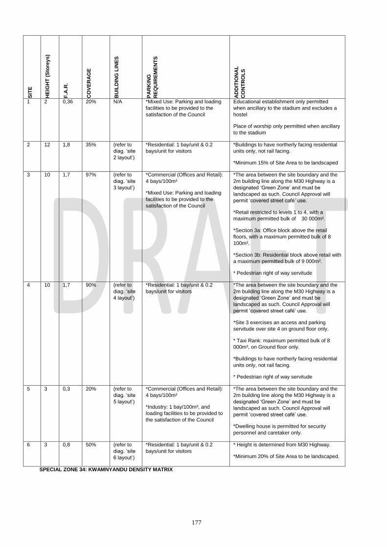
177
SPECIAL ZONE 34: KWAMNYANDU DENSITY MATRIX
SIT
E
HE
IGH
T (
Sto
reys)
F.A
.R.
CO
VE
RA
GE
BU
ILD
ING
LIN
ES
PA
RK
ING
RE
QU
IRE
ME
NT
S
AD
DIT
ION
AL
CO
NT
RO
LS
1
2 0,36 20% N/A
*Mixed Use: Parking and loading
facilities to be provided to the
satisfaction of the Council
Educational establishment only permitted
when ancillary to the stadium and excludes a
hostel
Place of worship only permitted when ancillary
to the stadium
2
12 1,8
35%
(refer to
diag. ‘site
2 layout’)
*Residential: 1 bay/unit & 0.2
bays/unit for visitors
*Buildings to have northerly facing residential
units only, not rail facing.
*Minimum 15% of Site Area to be landscaped
3
10 1,7
97%
(refer to
diag. ‘site
3 layout’)
*Commercial (Offices and Retail):
4 bays/100m²
*Mixed Use: Parking and loading
facilities to be provided to the
satisfaction of the Council
*The area between the site boundary and the
2m building line along the M30 Highway is a
designated ‘Green Zone’ and must be
landscaped as such. Council Approval will
permit ‘covered street café’ use.
*Retail restricted to levels 1 to 4, with a
maximum permitted bulk of 30 000m².
*Section 3a: Office block above the retail
floors, with a maximum permitted bulk of 8
100m².
*Section 3b: Residential block above retail with
a maximum permitted bulk of 9 000m².
* Pedestrian right of way servitude
4
10 1,7
90%
(refer to
diag. ‘site
4 layout’)
*Residential: 1 bay/unit & 0.2
bays/unit for visitors
*The area between the site boundary and the
2m building line along the M30 Highway is a
designated ‘Green Zone’ and must be
landscaped as such. Council Approval will
permit ‘covered street café’ use.
*Site 3 exercises an access and parking
servitude over site 4 on ground floor only.
* Taxi Rank: maximum permitted bulk of 8
000m², on Ground floor only.
*Buildings to have northerly facing residential
units only, not rail facing.
* Pedestrian right of way servitude
5
3 0,3
20%
(refer to
diag. ‘site
5 layout’)
*Commercial (Offices and Retail):
4 bays/100m²
*Industry: 1 bay/100m², and
loading facilities to be provided to
the satisfaction of the Council
*The area between the site boundary and the
2m building line along the M30 Highway is a
designated ‘Green Zone’ and must be
landscaped as such. Council Approval will
permit ‘covered street café’ use.
*Dwelling house is permitted for security
personnel and caretaker only.
6
3 0,8
50%
(refer to
diag. ‘site
6 layout’)
*Residential: 1 bay/unit & 0.2
bays/unit for visitors
* Height is determined from M30 Highway.
*Minimum 20% of Site Area to be landscaped.

178
SPECIAL ZONE 34: KWAMNYANDU DENSITY MATRIX

179
SPECIAL ZONE 34: KWAMNYANDU DENSITY MATRIX
SIT
E
HE
IGH
T (
Sto
reys)
F.A
.R.
CO
VE
RA
GE
BU
ILD
ING
LIN
ES
PA
RK
ING
RE
QU
IRE
ME
NT
S
AD
DIT
ION
AL
CO
NT
RO
LS
7
10 2.0
100%
(refer to
diag. ‘site
7 layout’)
*Commercial (Offices and Retail):
4 bays/100m²
*Crèche: To the satisfaction of the
council
* Height is determined from M30 Highway.
* 100% coverage denotes covered parking
only, and a build to line restriction, as shown
on site 7 layout, is imposed for structure
above.
*Retail permitted only up to and including
bridge level – this level to link to retail level
across the M30 Highway, allow for traffic
clearance below on M30 Highway.
8
1
*fro
m
floor
slab
1.0
100%
N/A *Special Zone: Parking and
loading facilities to be provided off
site, to the satisfaction of the
Council.
*Bridge to link site 3 and 7 structures, and this
will determine the length.
9
7 1.0
70%
N/A *Residential: 1 bay/unit & 0.2
bays/unit for visitors
*Commercial (Offices and Retail):
4 bays/100m²
*Creche: To the satisfaction of the
Council
* Height is determined from M30 Highway
Level.
*Only ground level residential permitted.
10
7 1,6
60%
(refer to
diag. ‘site
10 layout’)
*Residential: 1 bay/unit & 0.2
bays/unit for visitors
*Commercial (Offices and Retail):
4 bays/100m²
*Creche: To the satisfaction of the
Council
*Minimum 20% of Site Area to be landscaped.
11
2 0,03
or
455m²
(which
ever is
the
lesser)
2,6% or
400m²
(whichev
er is the
lesser)
(refer to
diag. ‘site
11 layout’)
*Mixed Use: Parking and loading
facilities to be provided to the
satisfaction of the Council
* Max. Heights, F.A.R., Coverage and Building
Lines apply to permanent structures/buildings.
*All and any facilities including children’s
playground, sport courts, ablutions, buildings,
access and parking not to exceed a footprint of
1800m², as per R.O.D.
12
8 0,036 20%
(refer to
diag. ‘site
12 layout’)
*Mixed Use: Parking and loading
facilities to be provided to the
satisfaction of the Council
* Max. Heights, F.A.R., Coverage and Building
Lines apply to building structures, not to
courts, playing fields etc.

180
SPECIAL ZONE 34: KWAMNYANDU SITE DIAGRAMS
SIT
E
HE
IGH
T (
Sto
reys)
F.A
.R.
CO
VE
RA
GE
BU
ILD
ING
LIN
ES
PA
RK
ING
RE
QU
IRE
ME
NT
S
AD
DIT
ION
AL
CO
NT
RO
LS
13
8 0,6
20%
(refer to
diag. ‘site
13 layout’)
*Residential: 1 bay/unit & 0.2
bays/unit for visitors
*Minimum 10% of Site Area to be landscaped.
* Conservation Reserve is part of the site
14
1 0,5
100%
(refer to
diag. ‘site
14 layout’)
*Special Zone: Parking and
loading facilities to be provided to
the satisfaction of the Council.
*Retail maximum permitted bulk of 4 300m².
15
12 1,5
40%
(refer to
diag. ‘site
15 layout’)
*Residential: 1 bay/unit & 0.2
bays/unit for visitors
*Minimum 20% of Site Area to be landscaped /
planted.
16
10 1,5
70%
(refer to
diag. ‘site
16 layout’)
*Commercial (Offices and Retail):
4 bays/100m²
*Mixed Use: Parking and loading
facilities to be provided to the
satisfaction of the Council
*Retail restricted to levels 1 to 4, with a
maximum permitted bulk of 17 400m².
*Section 16a: Office block permitted above
retail floors, with a maximum permitted bulk of
8 100m².
17
12 1,5
50%
(refer to
diag. ‘site
17 layout’)
*Residential: 1 bay/unit & 0.2
bays/unit for visitors
*Minimum 20% of Site Area to be landscaped.
18 12 1,5
50%
(refer to
diag. ‘site
18 layout’)
*Residential: 1 bay/unit & 0.2
bays/unit for visitors
*Minimum 20% of Site Area to be landscaped.
19 3 0,16 25% (refer to
diag. ‘site
19 layout’)
*Commercial (Offices and Retail):
4 bays/100m²
*Industry: 1 bay/100m², and
loading facilities to be provided to
the satisfaction of the Council
*Minimum 10% of Site Area to be landscaped.
20 2 60% Front – 1m
Side and
rear – 3m
1 bay per dwelling house *Minimum erf size of 180m2
*special consent required for a building in
excess of 2 storeys

181
SPECIAL ZONE 34: KWAMNYANDU SITE DIAGRAMS

182
SPECIAL ZONE 34: KWAMNYANDU SITE DIAGRAMS

183
SPECIAL ZONE 34: KWAMNYANDU SITE DIAGRAMS

184
SPECIAL ZONE 34: KWAMNYANDU SITE DIAGRAMS

185
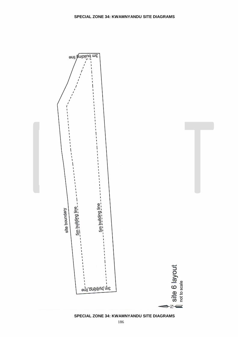
186
SPECIAL ZONE 34: KWAMNYANDU SITE DIAGRAMS
SPECIAL ZONE 34: KWAMNYANDU SITE DIAGRAMS

187
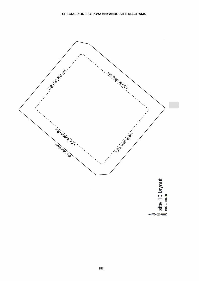
188
SPECIAL ZONE 34: KWAMNYANDU SITE DIAGRAMS

189
SPECIAL ZONE 34: KWAMNYANDU SITE DIAGRAMS

190
SPECIAL ZONE 34: KWAMNYANDU SITE DIAGRAMS

191
SPECIAL ZONE 34: KWAMNYANDU SITE DIAGRAMS
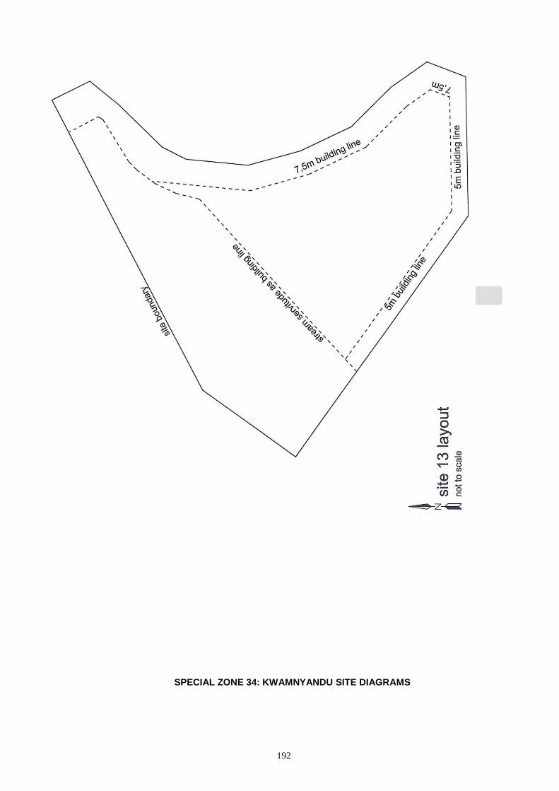
192
SPECIAL ZONE 34: KWAMNYANDU SITE DIAGRAMS
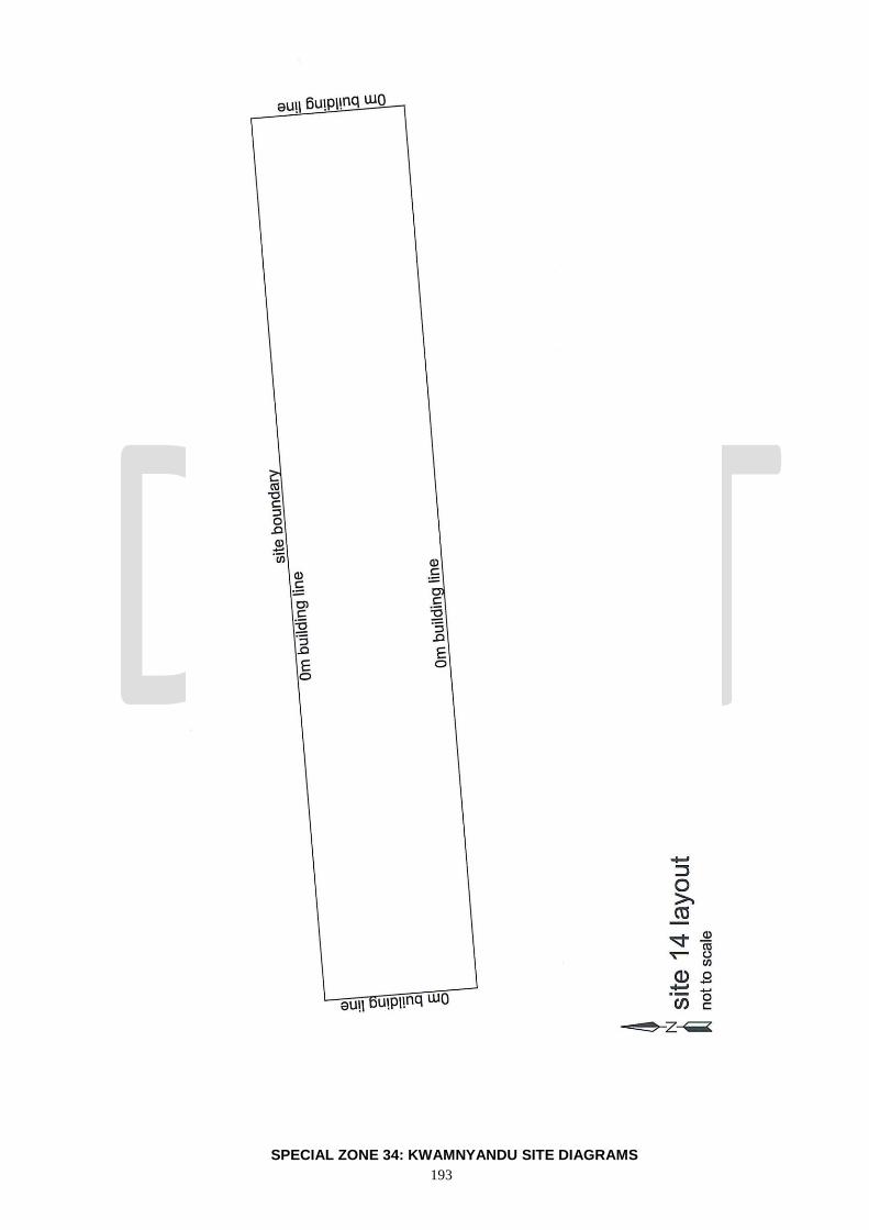
193
SPECIAL ZONE 34: KWAMNYANDU SITE DIAGRAMS

194

195
SPECIAL ZONE 34: KWAMNYANDU SITE DIAGRAMS

196
SPECIAL ZONE 34: KWAMNYANDU SITE DIAGRAMS
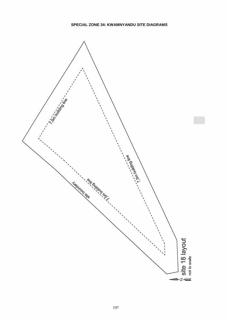
197
SPECIAL ZONE 34: KWAMNYANDU SITE DIAGRAMS
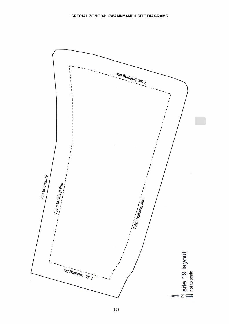
198
SPECIAL ZONE 34: KWAMNYANDU SITE DIAGRAMS
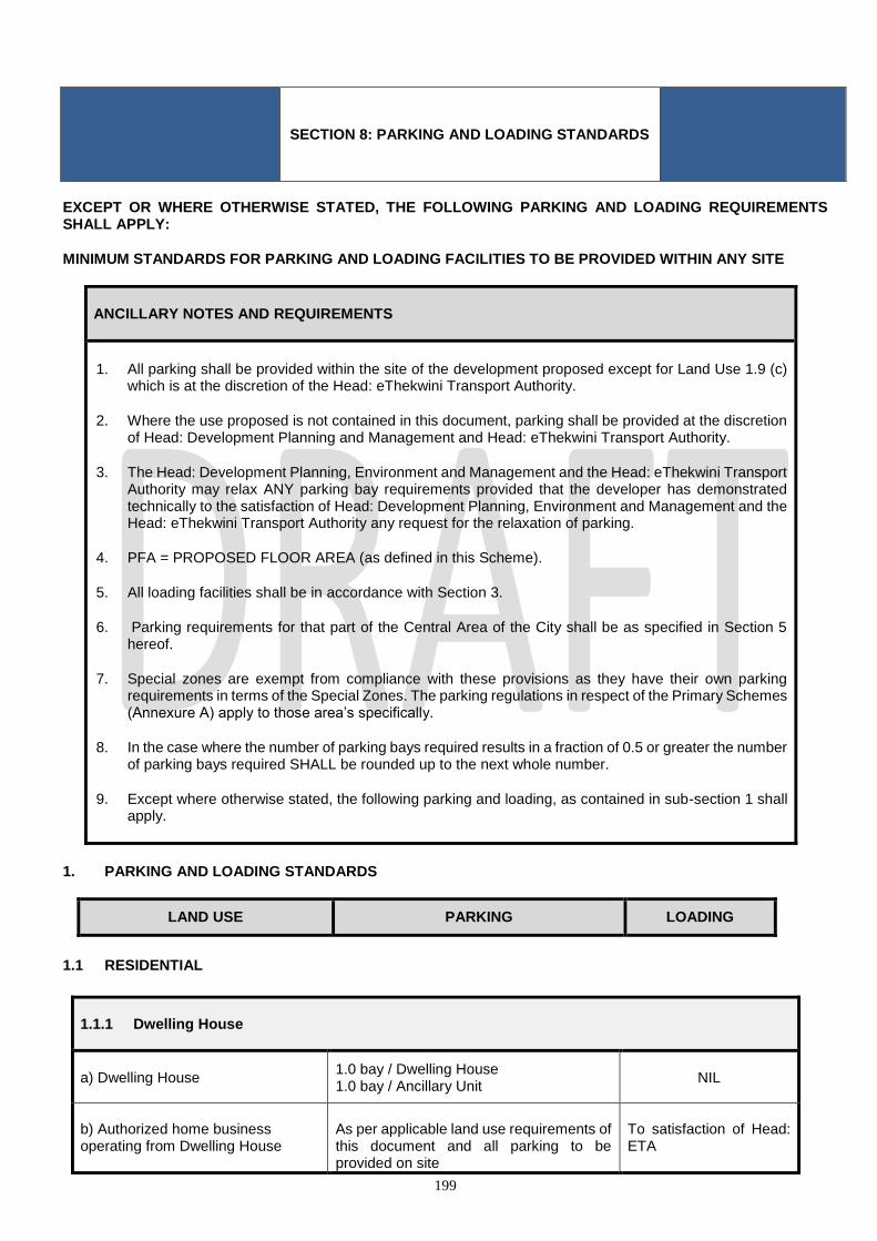
199
SECTION 8: PARKING AND LOADING STANDARDS
EXCEPT OR WHERE OTHERWISE STATED, THE FOLLOWING PARKING AND LOADING REQUIREMENTS SHALL APPLY:
MINIMUM STANDARDS FOR PARKING AND LOADING FACILITIES TO BE PROVIDED WITHIN ANY SITE
ANCILLARY NOTES AND REQUIREMENTS
1. All parking shall be provided within the site of the development proposed except for Land Use 1.9 (c) which is at the discretion of the Head: eThekwini Transport Authority.
2. Where the use proposed is not contained in this document, parking shall be provided at the discretion of Head: Development Planning and Management and Head: eThekwini Transport Authority.
3. The Head: Development Planning, Environment and Management and the Head: eThekwini Transport Authority may relax ANY parking bay requirements provided that the developer has demonstrated technically to the satisfaction of Head: Development Planning, Environment and Management and the Head: eThekwini Transport Authority any request for the relaxation of parking.
4. PFA = PROPOSED FLOOR AREA (as defined in this Scheme).
5. All loading facilities shall be in accordance with Section 3.
6. Parking requirements for that part of the Central Area of the City shall be as specified in Section 5 hereof.
7. Special zones are exempt from compliance with these provisions as they have their own parking requirements in terms of the Special Zones. The parking regulations in respect of the Primary Schemes (Annexure A) apply to those area’s specifically.
8. In the case where the number of parking bays required results in a fraction of 0.5 or greater the number of parking bays required SHALL be rounded up to the next whole number.
9. Except where otherwise stated, the following parking and loading, as contained in sub-section 1 shall apply.
1. PARKING AND LOADING STANDARDS
LAND USE PARKING LOADING
1.1 RESIDENTIAL
1.1.1 Dwelling House
a) Dwelling House 1.0 bay / Dwelling House 1.0 bay / Ancillary Unit
NIL
b) Authorized home business operating from Dwelling House
As per applicable land use requirements of this document and all parking to be provided on site
To satisfaction of Head: ETA
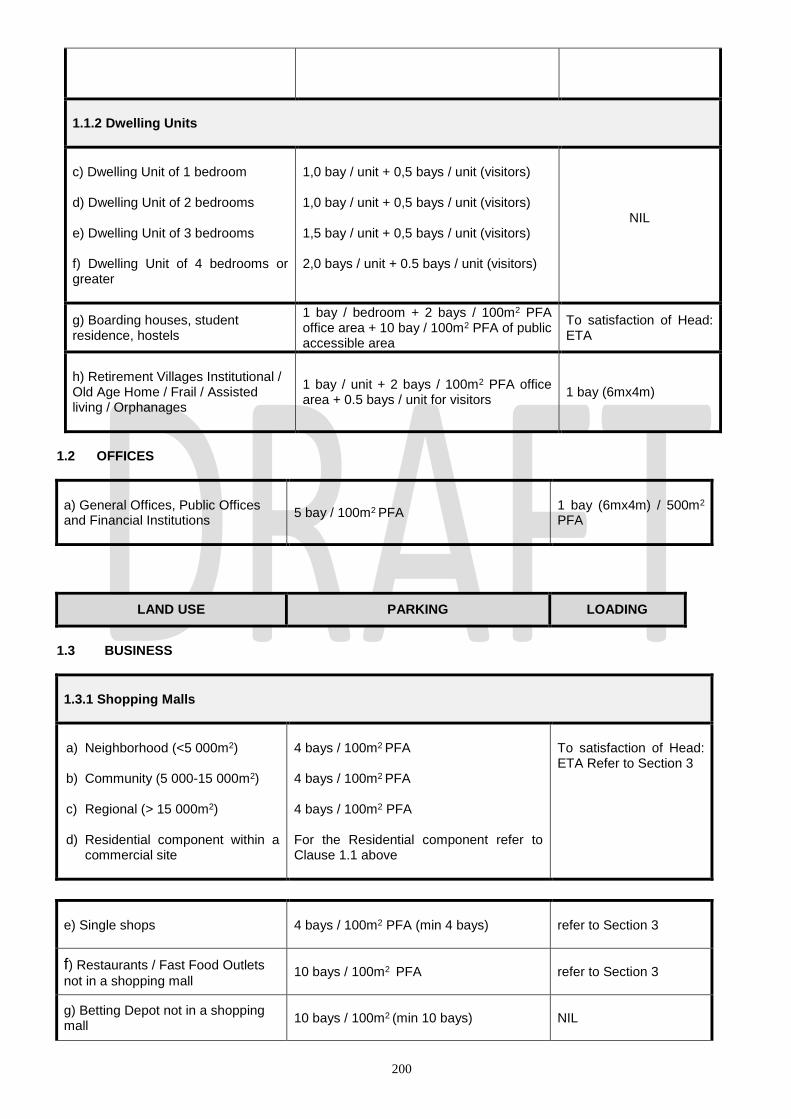
200
1.1.2 Dwelling Units
c) Dwelling Unit of 1 bedroom d) Dwelling Unit of 2 bedrooms e) Dwelling Unit of 3 bedrooms f) Dwelling Unit of 4 bedrooms or greater
1,0 bay / unit + 0,5 bays / unit (visitors) 1,0 bay / unit + 0,5 bays / unit (visitors) 1,5 bay / unit + 0,5 bays / unit (visitors) 2,0 bays / unit + 0.5 bays / unit (visitors)
NIL
g) Boarding houses, student residence, hostels
1 bay / bedroom + 2 bays / 100m2 PFA office area + 10 bay / 100m2 PFA of public accessible area
To satisfaction of Head: ETA
h) Retirement Villages Institutional / Old Age Home / Frail / Assisted living / Orphanages
1 bay / unit + 2 bays / 100m2 PFA office area + 0.5 bays / unit for visitors
1 bay (6mx4m)
1.2 OFFICES
a) General Offices, Public Offices and Financial Institutions
5 bay / 100m2 PFA 1 bay (6mx4m) / 500m2
PFA
LAND USE PARKING LOADING
1.3 BUSINESS
1.3.1 Shopping Malls
a) Neighborhood (<5 000m2) b) Community (5 000-15 000m2) c) Regional (> 15 000m2) d) Residential component within a
commercial site
4 bays / 100m2 PFA 4 bays / 100m2 PFA 4 bays / 100m2 PFA For the Residential component refer to Clause 1.1 above
To satisfaction of Head: ETA Refer to Section 3
e) Single shops 4 bays / 100m2 PFA (min 4 bays) refer to Section 3
f) Restaurants / Fast Food Outlets
not in a shopping mall 10 bays / 100m2 PFA
refer to Section 3
g) Betting Depot not in a shopping mall
10 bays / 100m2 (min 10 bays) NIL

201
h) Funeral Parlour 5 bays / 100m2 PFA (min 5 bays) 1 bay (6m x 4m)
1.4 MEDICAL
a) Consulting rooms 6 bays / 100m2 PFA (min. 6 bays) 1 bay (6mx4m)
b) Hospitals, Clinics, Medical Centers
1 bay / bed + 2 bays / 100m2 PFA office area + 6 bays / 100m2 PFA of consulting area
To satisfaction of Head: ETA
c) Veterinary Practice
2 bays / 100m2 PFA office area + 6 bays / 100m2 PFA of consulting area
To satisfaction of Head: ETA
LAND USE PARKING LOADING
1.5 INDUSTRIAL
a) Manufacturing
1 bay / 100m2 PFA (min 3 bays) + 2 bays / 100m2 PFA office area
Refer to Section 3
b) Warehousing
1 bay / 100m2 PFA (min 3 bays) + 2 bays / 100m2 PFA office area
Refer to Section 3
c) Dairies, Bakeries and Laundries
1 bay / 100m2 PFA + 2 bays / 100m2 office area
Refer to Section 3
d) Storage Yards
1 bay / 100 m2 PFA + 2 bays / 100m2 office area
Refer to Section 3
e) Multi-unit manufacturing / warehouse / factory
1 bay / 100m² PFA (min 3 bays/unit) + 2 bays / 100m2 PFA office area
Refer to Section 3
1.6 FUELING AND SERVICE STATION
a) Fueling and Service Station
2 bays / 100m2 PFA office area (min. 3 bays)
1 bay (17m x 4.3m) per station
b) Workshop Area 4 bays / working bay NIL
c) Sales (Automotive industry
products)
6 bays / 100m2 PFA (min. 2 bays) NIL
d) Convenience Shop ( excl. fast
food / food preparation outlets)
6 bays / 100m2 PFA (min.10 bays) 1 bay (9mx3m)

202
e) Restaurant / Fast Food Outlet 10 bays / 100 m2 PFA (min 6 bays) 1 bay (9mx3m)
f) Car wash (within fuelling and
service station)
4 bays / working bay NIL
LAND USE PARKING LOADING
1.7 PLACE OF WORSHIP
a) Main Auditorium 20 bays / 100m2 PFA (min. 20 bays) NIL
b) Priests House (manse) 1 bay / unit NIL
c) Special Building To satisfaction of Head: ETA Discretion of Head: ETA
1.8 EDUCATION
a) Nursery School / Crèche
1 bay / 6 children and 1 bay / office plus on-site drop off facility to satisfaction of Head: ETA
NIL
b) Primary School
2 bays / classroom or office plus on-site drop off facility to satisfaction of Head: ETA
NIL
c) Secondary School
2 bays / classroom or office plus on site drop off facility to satisfaction of Head: ETA
NIL
d) Colleges/ Universities/ Technikons, etc.
1 bay / 4 students + 1 bay / classroom and office plus drop off facility to satisfaction of Head: ETA
To satisfaction of Head: ETA
e) Other educational institution To satisfaction of Head: ETA
To satisfaction of Head: ETA

203
LAND USE PARKING LOADING
1.9 SPORT AND RECREATION
a) Community Centre 20 bays / 100m2 PFA (min.30 bays) 1 bay (6mx4m)
b) Halls 20 bays / 100m2 PFA (min 30 bays) 1 bay (6mx4m)
c) Sport Stadium (see note 1) 1 bay / 4 seats 1 bay (6mx4m)
d) Swimming Pools 1 bay / 4 seats (min.30 bays) 1 bay (6mx4m)
e) Libraries and Museums 20 bays / 100 m2 PFA (min. 30 bays) 1 bay (6mx4m)
f) Health studio / Gym
10 bays / 100m2 Public Accessible Area + 2 / 100m2 office area
1 bay (6mx4m)
g) Sport Field- Community facility 1 bay/4 seats (min. 30 bays) 1 bay (6mx4m)
1.10 TOURISM HOSPITALITY AND CONFERENCE
a) Convention Centre
Greater of 2 bays / 3 seats or 20 bays / 100m2 + 2 bays / 100m2 of office area
1 bay (6mx4m)
b) Hotel
2 bays / 3 rooms + 2 bays / 100m2 of office area + 10 bays / 100m2 PFA ancillary uses
1bay (9mx4m)

204
LAND USE PARKING LOADING
1.11 MOTOR DEALERSHIP
a) Motor Display Area 2 bays / 100m2 PFA 1 bay (17mx4.3m)
b) Workshop Area 4 bays / work-bay 1 bay (6mx4m)
c) Spares and Sales Area 5 bays / 100m2 PFA 1 bay (6mx4m)
d) Office Area 2 bays / 100m2 PFA NIL
1.12 CAR WASH
a) Car Wash 4 bays / work bay 1 bay (6mx4m)
b) Ancillary Office Area 2 bays / 100m2 PFA NIL
1.13 WORKSHOPS-VEHICLE REPAIRS AND FITMENT CENTRES
a) Workshops
4 bays / work bay + 2 bays / 100m2 PFA office area
1 bay (6mx4m)
b) Panel beating
4 bays / work bay + 2 bays / 100m2 PFA office / ancillary area
1 bay (9m x 4m)
1.14 FLEA MARKET
a) Trading area Parking at discretion of Head: ETA 1 bay (9mx3m)
1.15 ENTERTAINMENT
a) Night Club / Sports bars 10 bays / 100m2 PFA 1 bay (6mx4m)
b) Cinemas and Theatres (isolated) 1 bay / 4 seats (min 30 bays) 1 bay (6mx4m)
2. MULTI-UNIT MANUFACTURING/FACTORY/WAREHOUSING DEVELOPMENTS 2.1. Loading

205
2.1.1. Site Area < 2000m2
Factory Size
Abs. Minimum
< 300 m2 1 bay 6m x 4m/ factory OR 1 bay 9m x 3m / 2 factories + 1 bay 9m x 3m communal
>300 m2 1 bay 9m x 3m factory + 1 bay 9 m x 3m communal
PFA< 1500 m2
Factory Size
Abs. Minimum
< 300 m2 1 bay 6m x 4m / factory OR 1 bay 9m x 3m / 2 factory + 1 WB50 communal / 1500 m² PFA
>300 m2 1 bay 9m x 3m / factory + 1 WB50 communal/ 1500 m² PFA
PFA≥1500 m2
2.1.2 Site area ≥ 2000 m2
Factory Size
Abs. Minimum
< 300 m2 1 bay 6m x 4m / factory OR 1 bay 9m x 3m / 2 factories + 1 WB50 communal / 1500m² PFA
>300 m2 1 bay 9m x 3m / factory + 1 WB50 communal / 1500m² PFA

206
3. LOADING REQUIREMENTS 3.1. Bay Sizes
! WB50 - 17.0m x 4.3m ! Single Unit (SU) - 9.0m x 3.0m ! Bakkie - 6.0m x 4.0m
3.2. Type of Vehicle: 3.3. No. of Bays
o WB50 is required for every 1500 m² of PFA o SU is required for PFA < 1500 m² o The number of bays and type of vehicle are dependant on the site area, development proposed
and the proposed floor area (PFA). Example:
SA > 2000 m² SA < 2000 m²
FA (m²) WB50 SU WB50 SU
1000 1 - - 1
2000 1 1 1 1
2900 1 1 1 1
4000 2 (1) 1 (2) 2 (1) 1 (2)
6000 4 (3) [2] - (1) [2] 4 (3) [2] - (1) [2]
3.4. The Head: eThekwini Transport Authority may relax the loading bay requirement upon consideration of
circumstances peculiar to the development. 3.5. The maximum gradient of ramps/driveways to loading areas must be 10%. 3.6. The minimum height clearance for loading area’s shall be 4.50m. 3.7. All loading bays shall be provided within the site of the development proposed.
Floor Area

207
4. SCHEDULE OF GUIDING RULES FOR OFF-STREET PARKING FACILITIES
4.1 ALL DIMENSIONS IN METRES
PARKING AGLE
BAY WIDTH AISLE WIDTH
PERPENDICULAR DEPTH OF BAYS PARALLEL WIDTH OF BAYS
NO OVERHANG KERB OVERHANG
TWO-WAY TRAFFIC
90º 2,4 2,5 2,6 2,7 2,8 2,9 3,0
7,1 6,7 6,4 6,1 5,8 5,6 5,5 4,9 4.4
2,4 2,5 2,6 2,7 2,8 2,9 3,0
ONE-WAY TRAFFIC
0º
80º
70º
60º
50º
45º
2,4 2,5 2,6 2,7 2,8 2,9 3,0
2,4 2,5 2,6 2,7 2,8 2,9 3,0
2,4 2,5 2,6 2,7 2,8 2,9 3,0
2,4 2,5 2,6 2,7 2,8 2,9 3,0
2,4 2,5 2,6 2,7 2,8 2,9 3,0
2,4 2,5 2,6 2,7 2,8 2,9 3,0
6,7 6,3 5,9 5,5 5,1 4,7 4,3
5,9 5,5 5,1 4,7 4,3 3,9 3,5
4,5 4,1 3,7 3,2 3,0 3,0 3,0
3,4 3,2 3,0 3,0 3,0 3,0 3,0
3,0 3,0 3,0 3,0 3,0 3,0 3,0
3,0 3,0 3,0 3,0 3,0 3,0 3,0
4,9
5,3
5,4
5,5
5,3
5,2
4,4
4,7
4,8
4.8
4,7
4,6
2,4 2,5 2,6 2,7 2,8 2,9 3,0
2,44 2,54 2,64 2,74 2,84 2,94 3,05
2,55 2,66 2,77 2,88 2,98 3,09 3,19
2,77 2,89 3,00 3,12 3,23 3,35 3,46
3,13 3,26 3,39 3,53 3,66 3,79 3,92
3,39 3,54 3,58 3,82 3,96 4,10 4,24

208
4.2 Ramp Dimensions
INSIDE RADIUS
ONE-WAY TWO-WAY
RAMP WIDTH
OUTSIDE RADIUS
RAMP WIDTH OUTSIDE RADIUS
INSIDE LANE WIDTH
DIVIDING LINE RADIUS
3,0 4,0 5,0 6,0 7,0 8,0
4,1 4,0 3,9 3,8 3,7 3,7
7,1 8,0 8,9 9,8 10,7 11,7
6,6 6,5 6,3 6,1 6,0 5,9
9,6 10,5 11,3 12,1 13,0 13,9
3,5 3,4 3,3 3,2 3,1 3,0
6,5 7,4 8,3 9,2
10,1 11,0
4.3 Parallel parking bays should be 2,5m wide and 4,9m long with a manoeuvring bay 2,5m in length between each pair of bays. A minimum adjacent aisle width of 3m should be provided for gaining access. (see 8.6.15. below)
4.4 Vehicles must be parked in such a way that each vehicle can be freely moved in and out of its parking bay in a single manoeuvre.
4.5 The parking layout should be so designed that structural members such as columns, beams, walls, etc shall not obstruct the free manoeuvring of vehicles into and out of parking bays.
4.6 In awkward situations or in cases where other particular factors arise, the requirement of 4.9m depth of parking bay may be relaxed down to a minimum of 4,6m provided that the number of 4,6m bays does not exceed 10% of the total parking bays provided.
4.7 The gradient of continuous ramps should not exceed 1 : 7 provided however that for short sections, and in special circumstances, this gradient may be steepened but in no case should it be steeper than 1 : 5. Ramps to loading areas shall be maximum 10%.
4.8 Vertical curves between the ramps and the street access and between the ramps and parking floors should be provided with a minimum radius of 30m.
4.9 Correct super-elevation should be applied transversely across curved ramps, such super- elevation varying according to the horizontal radius of the curve, subject, in all cases, to the super-elevation not exceeding 1 : 10.
4.10 The inside turning radius on continuous ramps shall not be less than 4,3m.
4.11 The maximum gradient across a parking area is 1:15
4.12 The width of one-way driveways, ramps and entrances shall be a minimum of 3m. The width of two-way driveways and ramps shall be a minimum of 5m and a maximum of 9m. For a two-way driveway or ramp serving 6 or less parking bays, a 3m width may be allowed. A minimum 1,2m sidewalk must be provided along at least one side of the driveway or ramp. Minimum distance between physical obstructions for one-way driveways and ramps and two-way driveways and ramps must be 5m and 7m respectively. 4.13 Entrance widths shall be minimum 6m except for residential uses with less than 6 parking bays. A minimum of one access (ingress and egress) point must be provided for every 400 parking bays. The minimum height clearance for parking areas shall be 2,5m.
4.14 The Head: eThekwini Transport Authority may relax the provision of the Guiding Rules for Off-Street Parking in those cases where it is difficult or impractical to meet the required standards on account of one or more of the following factors:-
(a) The shape of the site. (b) There exists an approved building of significance. (c) The locality and character of the proposed development.

209
Fig.4: General Layouts
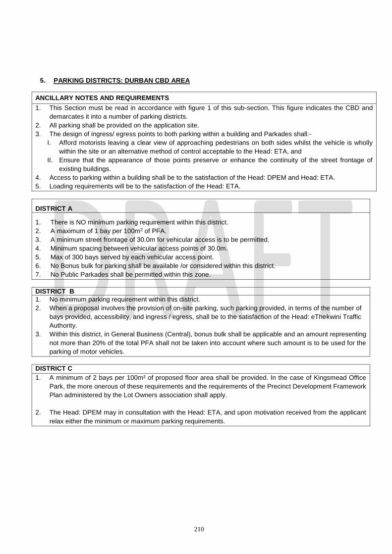
210
5. PARKING DISTRICTS: DURBAN CBD AREA
ANCILLARY NOTES AND REQUIREMENTS
1. This Section must be read in accordance with figure 1 of this sub-section. This figure indicates the CBD and
demarcates it into a number of parking districts.
2. All parking shall be provided on the application site.
3. The design of ingress/ egress points to both parking within a building and Parkades shall:-
I. Afford motorists leaving a clear view of approaching pedestrians on both sides whilst the vehicle is wholly
within the site or an alternative method of control acceptable to the Head: ETA, and
II. Ensure that the appearance of those points preserve or enhance the continuity of the street frontage of
existing buildings.
4. Access to parking within a building shall be to the satisfaction of the Head: DPEM and Head: ETA.
5. Loading requirements will be to the satisfaction of the Head: ETA.
DISTRICT A
1. There is NO minimum parking requirement within this district.
2. A maximum of 1 bay per 100m2 of PFA.
3. A minimum street frontage of 30.0m for vehicular access is to be permitted.
4. Minimum spacing between vehicular access points of 30.0m.
5. Max of 300 bays served by each vehicular access point.
6. No Bonus bulk for parking shall be available /or considered within this district.
7. No Public Parkades shall be permitted within this zone.
DISTRICT B
1. No minimum parking requirement within this district.
2. When a proposal involves the provision of on-site parking, such parking provided, in terms of the number of
bays provided, accessibility, and ingress / egress, shall be to the satisfaction of the Head: eThekwini Traffic
Authority.
3. Within this district, in General Business (Central), bonus bulk shall be applicable and an amount representing
not more than 20% of the total PFA shall not be taken into account where such amount is to be used for the
parking of motor vehicles.
DISTRICT C
1. A minimum of 2 bays per 100m² of proposed floor area shall be provided. In the case of Kingsmead Office
Park, the more onerous of these requirements and the requirements of the Precinct Development Framework
Plan administered by the Lot Owners association shall apply.
2. The Head: DPEM may in consultation with the Head: ETA, and upon motivation received from the applicant
relax either the minimum or maximum parking requirements.

211
FIGURE 1: PARKING DISTRICTS - CBD

212
SECTION 9: DEVELOPMENT STANDARDS
9.1 BASE TELECOMMUNICATIONS TRANSCEIVER STATIONS (CELLULAR MASTS)
9.1.1 INTENTION OF THE SCHEME (i) The Municipality, in considering proposals for the location of Base Telecommunications Transmission
Stations, shall be mindful of the need for the development of an effective and efficient communications system within the eThekwini Municipal area. In this regard, The Municipality shall give fair consideration to the requirements of the Service Providers to develop an effective and efficient communications system, and to the protection of the community in which such installations are to occur.
(ii) The installation of a Base Telecommunications Transmission Stations shall be undertaken in such a
manner that their impact upon the environment is minimized. The Base Telecommunications Transmission Station shall be as unobtrusive as possible through the choice of materials, color, depth of silhouette, height, and design which shall complement the aesthetics of the surrounding built and natural environment thereby minimizing the impact upon the environment.
(iii) In considering the appropriate location of a Base Telecommunications Transmission Station, the
applicant should be conscious of sites of historic, cultural and architectural importance. Cognisance must also be taken of the impacts installations may have upon open spaces, coastal regions and prominent ridges
9.1.2 Locational Provisions (i) Due consideration must be given to the impact of Base Telecommunications Transmission
Station on other developments and natural features, whether existing or contemplated by the Scheme and their location in relation to view corridors.
(ii) In the selection of a site for Base Telecommunications Transmission Station, consideration shall be given to the locational context of the proposed installation in respect of aesthetic suitability and environmental intrusion.
(iii) Antennae shall be installed on existing structures or existing masts.
(iv) The principle of multiple use of telecommunications masts by all network providers, shall applied
provided that a motivation for exemption from sharing may only be considered on the following basis:
(a) that no existing Base Telecommunications Transmission Station or suitable alternative
structures are located within the geographic antenna placement area required to the meet the applicant’s requirements;
(b) that the existing Base Telecommunications Transmission Station is not of sufficient height or structural strength to meet the applicant’s engineering requirements;
(c) that consideration shall be given to alternative sites where the cumulative RF emissions would
exceed the maximum levels permitted should additional transmission be attached to a mast or where the RF exclusion zone cannot be achieved;
(c) that there will be electromagnetic interference resulting from more than one antenna positioned
213
on a single telecommunications mast.
(v) Permission to share an existing Base Telecommunications Transmission Station shall not be unreasonably withheld by the owner of that Base Telecommunications Transmission Station.
(vi) Every applicant seeking to locate a new Base Telecommunications Transmission Station or modify
such Base Telecommunications Transmission Station, shall provide the Municipality with an inventory of the existing Base Telecommunications Transmission Station inclusive of the sites for which authority is being sought, within a 1000 metre radius of the Erf on which it is intended to erect a Base Telecommunications Transmission station.
(vii) When a cellular mast requires replacement, it shall be replaced with a mast designed to accommodate
multiple carriers.
(viii) No Base Telecommunications Transmission Station shall be erected on an Erf, which in the opinion of Municipality, has been identified as containing a building or structure of architectural, cultural, historic, or artistic importance, nor in an area set aside for conservation purposes, whether natural, physical or social, provided that the Municipality may, by Consent, relax this provision if it can be shown that the erection of a Base Telecommunications Transmission Station, shall not detract from the architectural, cultural, historic, artistic, natural, physical or social value of the site.
(ix) Where possible, the equipment room forming part of the Base Telecommunications Transmission
Station shall be sited to the rear of an Erf.
9.1.3 Visual Attributes
(i) Visual amenity and visual aspects relating to the Base Telecommunications Transmission Station shall be at the discretion of the Municipality.
(ii) Consideration shall be given to the context of the Erf in relation to its surrounding environment when
determining the height of the mast and selecting the type of camouflage appropriate to the area.
(iii) A rooftop antenna used as a Cellular Mast shall not protrude more than 6.00 metres above the highest point of the building or structure onto which it is erected, provided that the Municipality may, by Special Consent, relax this requirement. For the purposes of this sub-clause, lift motor rooms, air-conditioning plant and equipment rooms above the uppermost slab or roof of the building, shall be regarded as being the highest point of the building.
(iv) All forms of visible lighting on telecommunications masts shall be reduced to the minimum requirements for security as laid down by the South African Civil Aviation Authority with due regard for adjacent land uses.
(v) No advertising shall be permitted on telecommunications masts, provided that where an antenna is to
be installed on existing or proposed advertising structures, such advertising shall be to the satisfaction of the Municipality.
(vi) The equipment room shall be screened in such a manner that it shall be inconspicuous from public
view by using landscaping or materials and colors consistent with the surrounding environment. All screening shall in any event be to the satisfaction of the Municipality.
9.1.4 Safety
(i) The cellular network provider or network providers shall at all times comply with the requirements of
the Department of National Health and the International Commission on Non-Ionizing Radiation Protection with respect to safety standards.
(ii) The application for the installation of a Base Telecommunications Transmission Station shall be
accompanied by a notice of appointment of a certified engineer approved by the Municipality.
214
(iii) Reasonable measures shall be taken to restrict access to rooftop installations, other than for
maintenance purposes.
(iv) Every cellular network provider shall, on an annual basis, submit a report in which the applicant demonstrates that, where authority has been granted by the Municipality, there is full compliance with the standards as determined by the International Commission on Non-Ionizing Radiation Protection.
(v) All telecommunications masts shall comply with the standards as laid down by the South African Civil
Aviation Authority.
(vi) Access to the Base Telecommunications Transmission Station installation shall be controlled to the satisfaction of the Municipality.
(vii) In addition to 9.1.2 (vi) above every must be accompanied with an International Commission on Non-
Ionizing Radiation Protection affidavit, confirming compliance the World Health Organization and International Commission on Non-Ionizing Radiation Protection standards for emissions.
9.1.5 Environmental Issues
(i) Applications for Base Telecommunications Transmission Stations within sensitive areas, as
determined by the National Environmental Management Act No. 107 of 1998 and the Environmental Conservation Act No. 73 of 1989, as amended from time to time, are required to follow the procedure as laid down in the Environmental Impact Assessment Regulations.
(ii) Where necessary, an Environmental Management Plan providing guidelines relative to Erf preparation,
the construction phase and maintenance of the Base Telecommunications Transmission Station, inclusive of mitigating impacts on all facets of the environment, including the biophysical and social environment shall be submitted as part of the application to erect a Base Telecommunications Transmission Station.
(iii) The applicant shall ensure that the Erf and areas around the Erf disturbed by construction are
rehabilitated appropriately and to the satisfaction of the Municipality.
(iv) The cellular network provider or network providers shall decommission and remove a Base Telecommunications Transmission Station should:
(a) the Base Telecommunications Transmission Station constitutes a danger to persons or
property as determined by the Municipality;
(b) the Base Telecommunications Transmission Station becomes redundant in the event of changing technology;
(c) the Base Telecommunications Transmission Station is not operated for a period exceeding 18 months; and
(d) any other similar circumstances rendering the Base Telecommunications Transmission Station redundant.
(v) The site shall be restored to its original condition and to the satisfaction of the Municipality.
(vi) Where there are two or more cellular network providers using a single mast, this provision shall not become effective until all cellular providers cease using the mast.
(vii) The site and Base Telecommunications Transmission Station shall be maintained to the satisfaction
of the Municipality.

215
9.1.6 Planning Approval Procedure:
(i) An application for the erection of and use of land for a Base Telecommunications Transmission Station shall be made in accordance with the requirements of the National Building Regulations and Standards Act No. 103 of 1977, the Town Planning Ordinance and the provisions of this Scheme. The submission of an application shall be preceded by consultation between the applicant or its agent and the Municipality in order to facilitate the processing of the application in an efficient and effective manner.
(ii) An application for the erection of a telecommunications mast and associated equipment and antenna
shall be accompanied by the following documents:
(a) An application form and the prescribed fee.
(b) The prescribed number of copies of plans, of which two are in color, indicating the location of the structure within the Erf, all existing structures on the Erf, adjoining properties and their associated structures, the elevation of the proposed structure, elevation of the proposed structure in relation to surrounding properties within a 50 metre radius and any services present, proposed security measures for controlling access to the Erf concerned (particularly the fencing of the base station) and landscaping.
(c) A locality plan indicating the location of existing telecommunications masts within a radius of 1 000 metres from the position of the proposed mast.
(d) All copies of plans shall be drawn at an appropriate and legible scale.
(e) A radio plan indicating the Coverage achieved within a 1 000 metre radius of the Erf.
(f) A copy of the Record of Decision relating to the application from the Department of Agriculture and Environmental Affairs, failing which an environmental scoping report, or a letter of exemption from the Department of Agriculture and Environmental Affairs.
(g) A certificate of approval from the South African Civil Aviation Authority.
(h) In the case where multiple uses cannot be achieved, a letter of motivation, engineers reports and or photographs giving reasons for the inability to co-late.
(i) A letter of consent from the registered owner of the property granting consent for the application
to be submitted to the Municipality.
(j) Title Deeds where legislation requires their submission.
(k) Photographs which present an indication of the impact of the proposed structure as viewed from key points around the Erf.
An application in terms of sub-clause 9.1.6 (ii) is deemed to be an application submitted in terms of the applicable legislation, which requires the Consent of the Municipality.
(iii) An application for the installation of telecommunication equipment and antennae on an approved
building or structure shall be accompanied by the following documents:
(a) An application form and the prescribed fee.
(b) The prescribed number of copies of a plan, of which two are in color, indicating the location of the equipment and antennae within the site, existing structure on the site, adjoining properties and their associated structures, the elevation of the structure, any services present, proposed

216
security measures for controlling access to the equipment, antennae and landscaping to the satisfaction of the Municipality.
(c) A copy of the Record of Decision relating to the application site from the Department of Agriculture and Environmental Affairs, failing which an environmental scoping report, or letter of exemption from the Department of Agriculture and Environmental Affairs.
(d) A letter of consent from the owner of the property granting consent for the application to be
submitted to the Municipality.
(e) In the case of land to be leased from the Municipality, a copy of a letter of consent from the relevant Department.
(f) Photographs which present an indication of the impact of the proposed structure as viewed
from key points around the Erf.
(g) Title Deeds where legislation requires their submission.
An application submitted in terms of sub-clause 9.1.6 (iii) is deemed to be an application submitted in terms of the applicable legislation.
(iv) An application for the increase in height of an approved telecommunication mast or for antenna erected
at a greater height than the height that has been previously approved, or for an increase in the footprint of the Base Telecommunications Transmission Station shall require:
(a) In the case of a mast, a Consent application as set out in sub-clause 9.1.6 (ii) hereof; and
(b) In the case of antennae, the submission of a Building Plan application as set out in sub-clause
9.1.6 (iii) hereof.
(v) The replacement of telecommunication masts, equipment and antennae on approved structures, shall be deemed to be regarded as maintenance and provided that there is no material change to the telecommunications mast, equipment and antennae on approved structures, no application shall be required.
9.1.7 GENERAL REQUIREMENTS FOR THE SCOPING REPORT TO ERECT BASE
TELECOMMUNICATIONS TRANCMISSION STATIONS (CELLULAR MASTS)
9.1.7.1 APPLICANTS DETAILS:
(i) Name; (ii) Postal Address; (iii) Physical Address; (iv) Service Provider Name; (v) Service Provider Postal Address.
9.1.7.2 PROJECT DESCRIPTION:
(i) Details of the proposed structure, including ancillary uses; (ii) Physical address of the property; (iii) Property Description; (iv) Site “code name”.
9.1.7.3 SITE DESCRIPTION:
(i) General description of the biophysical environment (land form, flora and fauna) on the Erf and
surroundings (including the location of Red Data Species, the percentage and description of indigenous vegetation on the Erf);

217
(ii) Description of specific environment elements that will be affected by the activity and description of these impacts;
(iii) Description of mitigating measures to be implemented; (iv) Description of alternatives where these were considered and motivation for the preferred option.
9.1.7.4 PUBLIC CONSULTATION:
(i) Indicate how the proposal will be advertised (ii) Record any other public scoping undertaken (notification to adjacent owners, public meetings, etc) if
done prior to the submission of the application. (iii) Record of any public comments received from interested and affected parties.
9.1.7.5 COMPLIANCE WITH GENENRAL EXEMPTION:
(i) State whether the Erf affects or may affect any sensitive area as described in the General Exemption letter received from the Department of Agriculture and Environmental Affairs;
(ii) State whether the structure is to be constructed in terms of the General Exemption or, if application in terms of Regulation is required.
9.1.7.6 MAPPING:
(i) Erf layout plan indicating the location of the proposed infrastructure in relation to all existing
infrastructure and large trees and buildings within a 50 metre radius;
(ii) Erf location plan indicating the surrounding land uses. NOTE:
(a) In addition to the above, the standard Environmental Management Plan for construction and operation of the Erf, as described in the Letter of Exemption, must be submitted for approval. (b) The abovementioned documents must be submitted to the Municipality as part of the
application. (a) Applicants are to ensure proposed structures are in accordance to South African Civil Aviation
requirements.
9.2 DESIGN OF A FUELLING AND SERVICE STATION
9.2.1 The layout of a Fuelling and Service Station including the siting of pumps, buildings and vehicular ingress
or egress shall be to the satisfaction of The Municipality.
9.2.2 A Fuelling and Service Station having direct vehicular access to a major arterial road and or proposed
arterial road shall not be permitted, unless approved in specific terms by the Municipality.
9.2.3 The following pre-requisites and conditions shall be observed whenever it is proposed to erect a new, or
extend an existing Fuelling and Service Station:-
(i) No vehicular entrance and exit to a Fuelling and Service Station shall be within 150.0 metres of a
freeway interchange, 60.0 metres from an intersection with a which road in the opinion of the
Municipality is a major road or 20.0 metres from an intersection with any other road, unless
approved in specific terms by the Municipality.
(ii) The frontage of a Fuelling and Service Station Erf shall not be less than 36.0 metres in length,
unless approved in specific terms by the Municipality and the number, with and siting of all vehicular
218
access points across such frontage and the minimum distances between such points shall conform
to and be within the limits.
(iii) Dwarf walls or permanent structures to the satisfaction of the Municipality shall be erected on the
street frontage of the Erf so as to confine the movement of vehicles into or out of the Fuelling and
Service Station to authorized ingress and egress points.
(iv) No Fuelling and Service Station shall be established upon an Erf unless, in the opinion of The
Municipality, it has adequate depth so as to enable all activities to be carried on clear of the street
or road. Filler points for underground tanks shall be positioned so as to make it possible for tanker
vehicles to stand wholly within the curtilage of the Erf when re-charging the tanks and for such
vehicles to enter or leave the Erf in a forward direction.
(v) No pump island shall be less than 5.0 metres from any boundary of the Erf and all traffic routes
within the forecourt shall have a minimum width of 5.0 metres.
(vi) A Fuelling and Service Station shall have a minimum distance of clear visibility of 120 metres in
both directions along any road onto which traffic is discharged from the forecourt measured from a
height of 1,37 metres above the road at the exit point to an object 1,37 metres; provided that where
a street is provided into two or more road ways by means of a physical barrier, then the above
visibility shall only relate to the direction of approach along the road way adjoining the forecourt to
the Fuelling and Service Station.
(vii) A Fuelling and Service Station shall not be sited on a street having a gradient at any point within
120 metres of any access point to the Fuelling and Service Station steeper than 1 in 7, and access
ramps from the street shall not be steeper than 1 in 7 with vertical curves of at least 30 metres
radius at the top and bottom of ramps.
(viii) Any Fuelling and Service Station shall be sited and designed so as to satisfy the Municipality that
traffic entering and leaving the Erf will not adversely affect movement of pedestrians or vehicles on
any heavily trafficked road or place.
(ix) In view of the interference with amenity which Fuelling and Service Stations in predominantly
residential areas are likely to give rise, by virtues of such matters as fume, odours, noise, conjection
of traffic unusually long hours of operation and so on, an application for a Fuelling and Service
Station in such an area shall only be granted if the applicant is able to establish that such a facility
is necessary in order to meet the needs of the residents of the area.
(x) The argument based on the solo-site system that all brands of fuel shall be available within any
particular area shall not be taken into account when considering applications for the establishment
of Fuelling and Service Stations.
9.2.4 The Municipality may relax any of the requirements of sub-section 9.2.3 other than the requirements
prescribed in paragraphs ii, iii and viii if it is satisfied that no interference with the amenities of the
neighbourhood existing or as contemplated of the Scheme will result or that the development in
accordance with such requirements will be less harmonious with adjoining properties than would be the
case if the requirements were relaxed; provided that no relaxation shall be granted so as to permit a
vehicular access point having a width along the street frontage of the site of less than 3 metres or not
more than 9 metres.
9.2.5 Where Special Consent authorizing the sale of motor vehicles at a fuelling and Service Station is granted,
it shall be subject to the condition that all such vehicles are displayed for sale or stored pending sale,
only in showrooms and /or on those portions of the site, the situation and layout of which have been
approved by the Municipality.
9.2.6 Where a Fuelling and Service Station has been established on part of the site other than one zoned for
a Fuelling and Service Station purposes, the use of the remainder of the site for any permitted uses shall
219
be subject to such conditions as the Municipality may consider necessary in order to obviate conflict
between vehicles using the Fuelling and Service Station and pedestrians and other vehicles using the
remainder of the site.
9.3 DESIGN AND LAYOUT FOR A MOBILE HOME PARK DEVELOPMENT
9.3.1 The written authority of the Municipality for the establishment of a Mobile Home Park Development shall only
be given if the design and layout is in accordance with the standard laid down in the code of practice for Mobile
Homes published by the South African Bureau of Standards (publication SABS 0130-1976). The minimum
number of homes to be sited in a Mobile Home Park Erf may in certain circumstances be less than fifty (50) in
number, where topography, vegetation availability of services or the use of adjoining recreational facilities in
the same ownership may in the opinion of the Municipality, warrant a lesser number.
9.3.2 The applicant shall submit the following for approval:
(a) A detailed plan for the proposed Mobile Home Park development to a scale of not less than 1:500 showing
where applicable:
(a) the full extent thereof;
(b) any existing buildings thereon, their details of construction and proposed use;
(c) 1.0m contour and all major topographical features;
(d) any servitudes and building line restrictions; and
(e) the proposed layout and landscaping of the Mobile Home Park development; the road and footpath
system; reticulation systems for water, sewage, stormwater drainage and electricity; street and other
lighting; the Mobile Home stands with their areas and dimensions and areas which are reserved for:
- community facilities showing proposed buildings for various activities;
- recreational purposes showing their types and extent;
- administration and other specified purposes; and
- any other features which may be relevant or required by the Municipality; provided that a series
of plans to the same scale indicating the required details may be submitted in place of a single
detailed plan.
(ii) A site plan to a scale of not smaller than 1:1000 showing:
(a) the proposed Mobile Home Park development, 2m contours and all existing and proposed buildings
thereon;
(b) all adjoining roads, streets and rights of way; and
(c) any other documents which the Municipality may reasonably require.
9.3.3 Where, in the opinion of the Municipality, a road within a Mobile Home Park development should serve the
public, the Municipality may require that the road be registered as a public road, provided that for the purpose
of the Coverage calculation, the area of the public road shall be included in the gross site area.
9.3.4 A turning space shall be provided to the satisfaction of the Municipality at end of every cul-del-sac.
9.3.5 The minimum width of a road carriageway within a Mobile Home Park development shall be 3.0m where the
carriageway is one-way and 5.5m where the carriageway is two-way.
9.3.6 Each Mobile Home stand shall have a minimum area of 450m2.
9.3.7 Not more than 30% of the Mobile Home stand shall be covered by the home and any accessory structure.
220
9.3.8 A minimum of 10% of the usable area of the Mobile Park development shall be allocated for usable common
open space and, where required by the Municipality, shall include a separate fenced-off area for children.
9.4 IMPORTANT BUILDINGS AND OBJECTS (see list at Annexure B)
Recognising the unique value of the architectural and historical heritage of the city, the Municipality has
prepared a comprehensive list of places and buildings which are important for their architectural, historical or
artistic contribution to the general environment. The Municipality wishes to control the demolition and
development of the identified items to ensure their proper conservation, and is desirous of providing
encouragement and incentives through the relaxation of any provisions of the town planning scheme by Special
Consent, where such relaxations are in keeping with the conservation objectives.
9.4.1 (a) No person shall demolish all or part of an Important Building without the prior written approval of
the Municipality.
(b) No person shall alter or redecorate any Important Object which is listed in Annexure B without the
prior written approval of the Municipality.
9.4.2 Notwithstanding any other provision of this scheme, the Municipality may, by Special Consent, relax
any provision of this scheme in respect of the site upon which an Important Building or Object stands
and the Important Building or Object itself provided that it can be shown to the Municipality’s satisfaction
that such relaxation is necessary and will :-
(a) ensure the conservation of either the architectural, historic or artistic value of the Important
Building or Object.
(b) not reduce the architectural, historic or artistic value of the Important Building or Object; and
(c) not unduly interfere with the amenities of the neighbourhood existing or as contemplated by the
scheme,
Provided further, that the Municipality’s authority and not its Special Consent shall be required where
the proposed relaxation does not involve a change in use and will affect the adjoining property only and
the written consent of the registered owner of such adjoining property has been obtained.
9.5 DURBAN METROPOLITAN OPEN SPACE SYSTEM CONTROLLED AREA.
(a) Without the prior written approval of the Municipality, no person shall within a D’MOSS Controlled Area
(i) develop, excavate or level any land; or
(ii) remove any natural vegetation; or
(iii) erect any structure of any nature whatsoever; or
(iv) dump on; or
(v) carry out any work.
(b) No such approval shall be given unless, after due examination the Municipality is satisfied that any such development, erection or other work referred to in paragraph (a) hereof can be carried out without degrading, destroying, or negatively impacting on the integrity of the biodiversity and/or environmental services found or generated within the D’MOSS Controlled Area .
(c) (i) For the purpose of any examination referred to in paragraph (b), the applicant shall,
221
where required by the Municipality, submit such plans or other supporting documentation as the Municipality may require.
(ii) Without affecting the generality of the aforegoing, such plans and supporting documentation may be required by the Municipality to be certified as being correct by an appropriately recognized or registered Environmental Consultant.
(d) The Municipality may impose conditions in terms of its approval and these may include, but
may not be restricted to:- (i) restricting the form or nature of the building or structure; (ii) limiting the size and/or shape of the building or structure; (iii) prescribing or restricting the materials of which the building or structure is to be
constructed; (iv) determining the siting of any building or structure and of any soakpits or other drainage
works; (vi) prohibiting or controlling any excavation , the construction of any roadways, paths and
other garden features; (vii) prohibiting or controlling the removal of any natural vegetation; (viii) controlling any other aspects which the Deputy Head: Environmental Planning and
Climate Protection considers to be necessary.
(e) In any approval or any conditions as may be specified by the Municipality above, the applicant
shall enjoy a right of appeal to the relevant Appeal Authority in terms of Provincial or National
Planning legislation.
9.6 COASTAL MANAGEMENT CONTROLLED AREA.
9.6.1 Without the prior written approval of the Municipality, no person shall within the Coastal
Management Controlled Area:-
a) develop, excavate or level any erf; or
b) remove any natural vegetation from any erf; or
c) erect any structure of any nature whatsoever on any erf; or
d) dump on or in any erf; or
e) carry out any work or undertake any activity upon any erf which may compromise the intention of the Coastal Management controlled area as stated in the definition.
9.6.2 No such approval shall be given unless, after due examination by the Municipality and subject
to such conditions as may be specified by the Project Executive: Coastal Policy, the Municipality is satisfied that any such development, erection or other work referred to in paragraph (9.6.1) hereof can be carried out in compliance with the Integrated Coastal Management Act, Coastal Management By-laws, policies and any other legislation.
9.6.3 For the purposes of any examination referred to in Paragraph (9.6.2) hereof,
The applicant shall, where required by the Municipality, submit such plans or other supporting documentation as the Municipality may require.
Without affecting the generality of the aforegoing, such plans and supporting documentation may be required by the Municipality to be certified as being correct by an appropriately recognised or registered Professional Coastal Engineer.
9.7 RENEWABLE ENERGY INSTALLATIONS
(i) Intention of the Scheme The Municipality, in considering proposals for the location Renewable Energy Installations, shall be mindful of
the need for a reduction on the reliance on Fossil fuels as a National prerogative. The installation of Renewable
Energy Installations shall be undertaken in such a manner that their impact upon the environment is minimized.
The Renewable Energy Installation shall be as unobtrusive as possible thorough the choice of materials,
colour, depth of silhouette and design which shall complement the aesthetics of the surrounding built and
natural environment thereby minimizing the impact upon the environment.

222
An installation shall only be considered by the Municipality once all Environmental (in terms of National
Environmental Management Act, Act 107 of 1998 and relevant Environmental Regulations) and Heritage
approvals (in terms of KwaZulu-Natal Heritage Act, Act No 4 of 2008) are in place.
(ii) Nothing in this scheme shall prohibit or restrict the following renewable energy installations provided that:
For Freestanding Solar Water Heaters or Photovoltaic (PV) Installations
(a) A solar water heater or Photovoltaic installation located on an erf but not attached to a building, other than through the necessary plumbing and/or cabling, that is no more than 3 metres in height shall be treated as ancillary to the land use on the site. Subject to this condition, no Planning Application is required other than a building plan.
(b) The location of the solar water heater or Photovoltaic installation must comply with all building lines, side space and rear space requirements of the relevant Scheme. Any encroachments will require an application to relax the building line, side space or rear space.
(c) If the free standing installation is more than 3 metres in height above finished ground level, then an application for Special Consent is required. The Head: Development Planning, Environment and Management may waive compliance with the full Special Consent procedure if the written consent of the registered owner of each adjoining property and such other properties as the Head: Development Planning Environment and Management may direct, is first obtained and furnished to the Municipality.
(d) The application for Special Consent must address visual impact on surrounding residents or occupants.
For Solar Water Heater and Photovoltaic installations attached to a roof
(a) A Solar Water Heater or Photovoltaic installation attached to the roof of a building, with no stand higher than 1,5 meters above the roof line, shall be treated as ancillary to the land use and no planning application shall be required other than a building plan, subject to it being flush with the roof.
(b) Installations requiring the construction of stands for the installation higher than 1,5m above the roof line shall be permitted only by application for Special Consent. The Head: Development Planning, Environment and Management may waive compliance with the Special Consent procedure if the written consent of the registered owner of each adjoining property and such other properties as the Head: Development Planning Environment and Management may direct, is first obtained and furnished to the Municipality.
(c) The application for Special Consent must address visual impact on surrounding residents or occupants.
For Wind Turbines
(a) All wind turbines, including a wind farm, shall be permitted only by a full Special Consent application.
(b) The swept area of any standalone or attached wind turbine blade must be no more than 7.1 square metres (3 metres in diameter).
(c) The distance between ground level and the lowest part of any free standing wind turbine blade must not be less than 3.5 metres.
(d) The swept area of any free-standing wind turbine blade shall at no point extend over or beyond the boundary line of the site upon which it is to be erected.
(e) No part of a wind turbine (including blades) may encroach into the building line, rear space or side space of a lot as determined by the Scheme. If an encroachment is anticipated this must be addressed in the Special Consent application.
(f) Should a wind turbine exceed the height restrictions of the erf, the Special Consent application

223
must address relaxing the height restrictions with respect to the wind turbine only.
SECTION 10: LIST OF
AMENDMENTS

224
SECTION 11: APPENDICES
11.1 Appendix 1: Diagrams 11.1.1 Appendix 1.1 – 10 Kenneth Kaunda Road, Athlone, Durban North (Development Facilitation Table for “Hotel” – see Additional Control – 9)

225
11.1.2 Appendix 1.2: 44 Netford Road, Bluff (Development Facilitation Table for “Medium Density Housing” – see Additional Control 3)

226
Scale: 1:750
11.1.3 Appendix 1.3 – (For Additional Controls section of Development Facilitation Table for “Special

227
Zone 27”)

228
11.1.4 Appendix 1.4 – (For Additional Controls section of Development Facilitation Table for “Special Zone 3”)

229
SECTION 12: ANNEXURES
12.1. Annexure A: Important Buildings and Objects list 12.2. Annexure B: C3 (Corridor) Land Use Strategy

230
C3 (Corridor) Land Use Strategy The C3 Corridor runs from the northern suburbs of the City – in particular Bridge City; to that of the Inner West – Pinetown and Outer West regions. It is a piece of transport infrastructure that allows people who live in the northern part of the city to access employment opportunities along the Corridor. It is a piece of transport infrastructure that is modelled on Transit Orientated Development- a concept that is promoted by National Treasury in an attempt to ensure and promote sustainability.
It must be noted that it is common cause for infrastructure to follow planning; however in this instance- planning has followed the installation of infrastructure. The IPTN zones are a strategic intervention that are supportive of the C3 transport orientated corridor, their objectives to include the following strategy:- ● Promoting infill and densification ● Encouraging development and redevelopment ● Directing employment, mixed use development and higher density ● Developing and strengthening transit orientated development along a major road component ● Creating employment opportunities through development and redevelopment ● Encourages the use of non-motorised transport ● Translation into an implementation plan for delivery Where any property that is designated as such in this Scheme, the development or use of any land in such zones shall be subject to the provisions of such special conditions as may be prescribed in the Development Facilitation Tables of such zones, and read in conjunction with Plan No. LU_STRAT_RADI_OCT 2017, as may be amended from time to time. Parking Parking within the 400m concentric circles as depicted on Plan No. LU_STRAT_RADI_OCT 2017, inclusive of the Bridge City Zone notwithstanding its provisions, is not required but is dependent on the developer. Parking for the remaining IPTN zones shall be in accordance with the provisions of Section 8 of the Scheme, provided further, that in respect of the area located between the 400m and 800m concentric circles, that the Head: Development Planning Environment and Management may at his discretion and on receipt of convincing supporting reasons, relax the provisions of Section 8. All other provisions of the Durban Scheme may need the Special Consent of the Municipality that relate to other clauses within this Scheme. Reference is made to the ‘C3 Integrated Development Corridor Plan’ created by Iyer: Planning Urban Design Architecture, 2017.


