

The premium on city-centre parking led this housing co-operative to build an underground carpark and use income as cross-subsidy for higher scheme development standards. What littleparking that is provided for residents invents a variation of on-street.
View from north-west corner of the perimeter block towards allocated bays.
Date 2001
Developers Coin Street Community Builders
Architects Haworth Tompkins
Building form 3 and 4 storey orthogonal block with landscaped internal square
Dwelling types townhouses, maisonettes and flats
Density 90 homes to the hectare
Parking 41%
Iroko Housing Co-operative, Coin Street, London SE1
38
Description
Coin Street on London's South Bank is a benchmark for community-ledaffordable housing. So first impressionsof the co-operative's most recentresidential development surprise withmodest parking provision for residentsin 59 mostly large houses, but anunderground car park for thosecommuting to South Bank.
But it is part of a grand plan. The three-side perimeter block has a landscapedsquare with a 260-space car parkbeneath operated by NCP. This doesnot offer free car parking spaces orconcessionary rates to residents.Instead, the income from the car parkcross subsidises the entire freeholdowned by Coin Street CommunityBuilders. It paid for generous spacestandards and specification, and nowmaintains a high-quality public realm on the roads linking the development to other blocks which puts other streetswithin the local authority to shame.
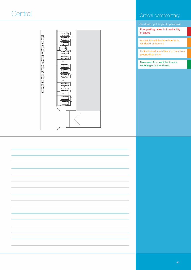
This pleasant street environmentaccommodates two simple controlledparking solutions on the two quieterstreets enveloping the perimeter block.Arranged in two and three bays to the
west, and in end-to-end layby style tothe east, the parking zones are definedby changes of colour, texture, andmaterial. Granite setts separate theprecast concrete paviors leading todwelling entrances, and buff bondedgravel defines the walkways betweenstraightforward blacktop hardstandingsfor unallocated but controlled spaces. On the west side of the site, exposed
aggregate plinths with reconstitutedstone copings and metal railings areintegrated with elaborately detailedbinstores. These bin stores are used on the north side of the block to definepublic and private realm, and againhere they articulate a hierarchy ofpedestrian routes, one between binstore and house more private than theother between car and carriageway.
A

Blank ground floors limit surveillance and depend on upper storeys. Pedestrians face a choice between private or more public route past cars.
39 English Partnerships
Iroko Housing Co-operative, Coin Street, London SE1A On street: right angled to pavement
Inner courtyard over NCP underground. Details make space private but obscure surveillance.
Cross-reference
See also pages 47, 79 and 117
Notes
40
Critical commentaryCentral
Poor parking ratios limit availability of space
Access to vehicles from homes isrestricted by barriers
Limited visual surveillance of cars fromground-floor units
Movement from vehicles to carsencourages active streets
On street: right angled to pavement

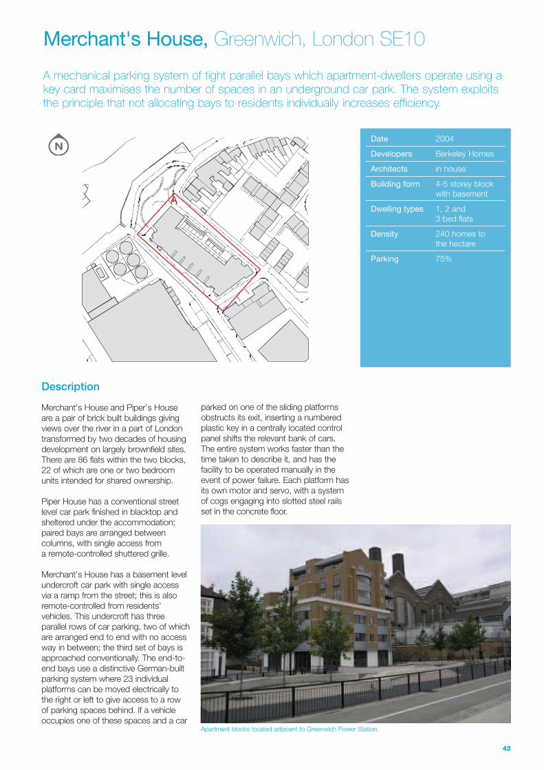
A mechanical parking system of tight parallel bays which apartment-dwellers operate using akey card maximises the number of spaces in an underground car park. The system exploitsthe principle that not allocating bays to residents individually increases efficiency.
Apartment blocks located adjacent to Greenwich Power Station.
Date 2004
Developers Berkeley Homes
Architects in house
Building form 4-5 storey block with basement
Dwelling types 1, 2 and 3 bed flats
Density 240 homes tothe hectare
Parking 75%
Merchant's House, Greenwich, London SE10
42
Description
Merchant's House and Piper's House are a pair of brick built buildings givingviews over the river in a part of Londontransformed by two decades of housingdevelopment on largely brownfield sites.There are 86 flats within the two blocks,22 of which are one or two bedroomunits intended for shared ownership.
Piper House has a conventional streetlevel car park finished in blacktop andsheltered under the accommodation;paired bays are arranged betweencolumns, with single access from a remote-controlled shuttered grille.
Merchant's House has a basement levelundercroft car park with single access via a ramp from the street; this is alsoremote-controlled from residents'vehicles. This undercroft has threeparallel rows of car parking, two of whichare arranged end to end with no accessway in between; the third set of bays isapproached conventionally. The end-to-end bays use a distinctive German-builtparking system where 23 individualplatforms can be moved electrically tothe right or left to give access to a row of parking spaces behind. If a vehicleoccupies one of these spaces and a car
parked on one of the sliding platformsobstructs its exit, inserting a numberedplastic key in a centrally located controlpanel shifts the relevant bank of cars.The entire system works faster than thetime taken to describe it, and has thefacility to be operated manually in theevent of power failure. Each platform hasits own motor and servo, with a systemof cogs engaging into slotted steel railsset in the concrete floor.
A
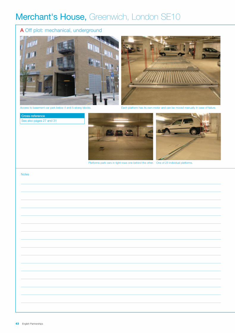
Access to basement car park below 4 and 5-storey blocks. Each platform has its own motor and can be moved manually in case of failure.
43 English Partnerships
Merchant's House, Greenwich, London SE10A Off plot: mechanical, underground
Platforms park cars in tight rows one behind the other. One of 23 individual platforms.
Cross-reference
See also pages 27 and 31
Notes
44
Critical commentaryCentral
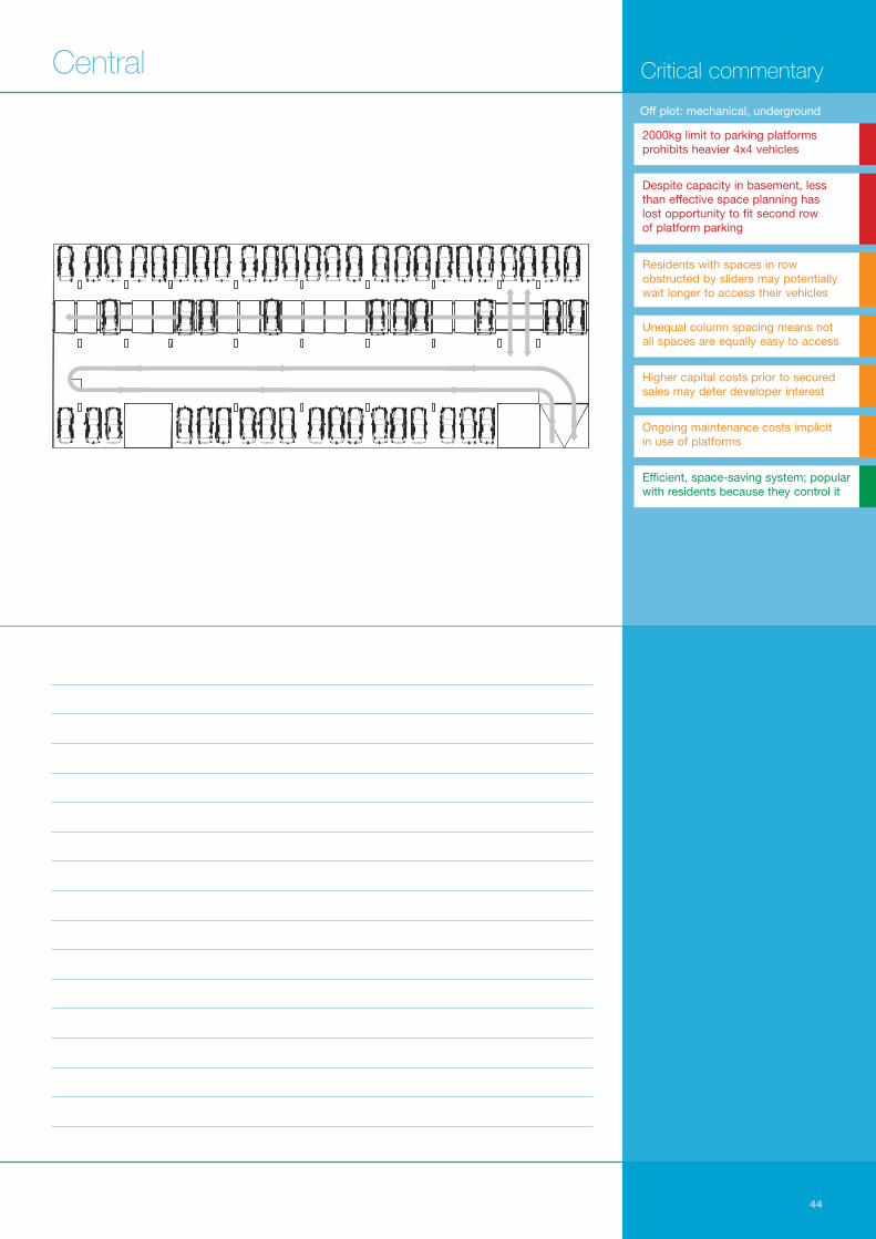
2000kg limit to parking platformsprohibits heavier 4x4 vehicles
Despite capacity in basement, lessthan effective space planning has lost opportunity to fit second row of platform parking
Residents with spaces in rowobstructed by sliders may potentiallywait longer to access their vehicles
Unequal column spacing means not all spaces are equally easy to access
Higher capital costs prior to securedsales may deter developer interest
Ongoing maintenance costs implicit in use of platforms
Efficient, space-saving system; popularwith residents because they control it
Off plot: mechanical, underground


High-quality public realm, new housing and commercial premises are reinventing Glasgow'shistorical sink estates as home to a range of incomes. Security issues are addressed with all parking on street, including in wide boulevards, with extensive surveillance over bays.
A block by architects Holmes Partnership showing how deep pavements at block corners are protected.
Date 2003
Developers Crown Street Regeneration Project with various housebuilders
Architects Hypostyle with CZWG
Building form 4 storey perimeterterraces
Dwelling types 2, 3 and 4 bedroom flats and maisonettes; retail units
Density 98 homes to the hectare
Parking ratio 115%
Queen Elizabeth Square, Gorbals, Glasgow
46
Description
Queen Elizabeth Square, an area of up to550 homes, is the second half of a largerredevelopment of the Gorbals collectivelyknown as Crown Street. Historically,tenement flats were set over shops atstreet level with a space in the backswhich the new scheme acknowledges as landscaped zones integral to thecommunity of the buildings (rather than a place to absorb refuse disposal orwashing, as had once been).
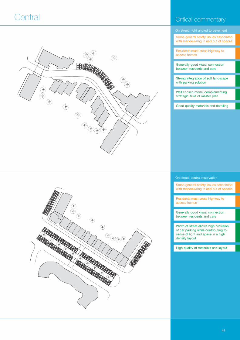
The new scheme projects a hard urbanouter edge with homes up to the backline of the pavement, surrounding thesofter, private centre. Car parking isexclusively on street and in QueenElizabeth Square is unallocated afterattempts to allocate in the earlier phasehad met problems. However, about 85% is privately maintained by theregeneration company for residents (but not controlled): granite setts indicatea bay is not adopted.
Bays are arranged in two variations of a classical bay system set at right angles to wider than usual pavements; atcorners in the block plan where there is no parking provision possible, anexceptionally deep pavement results.
The first variation locates vehiclesimmediately within this pavement zone;maisonettes arranged below the twolevels of flats above have a slightly raisedground floor to ensure some privacy. Thesecond version uses a broad boulevarddesign with two rows of cars at rightangles to the road in its landscapedcentre, and carriageways either side.Boulevards run mostly east-west over
the site, or in areas where the geometrysupports this formal model; characteristiccurves to facades elsewhere use thepavement system. Surface materials arepaviors or setts laid to give geometricpatterns. These are supported whereparking is discouraged on thepavement's deep corners with stainlesssteel bollards, adding to the impressionof a high quality robust environment.
A
B

Shadows over bays demonstrate how many homes overlook bays. Staggered properties with French windows and gable lights boost surveillance.
47 English Partnerships
Queen Elizabeth Square, Gorbals, Glasgow A On street: right angled to pavement
Bays, carriage and footpath share surface finish. Pinchpoints help to build defensible space.
Cross-reference
See also pages 39, 79 and 117
Two levels of flats topping maisonettes look onto right angled bays. Traffic-calming raised tables make it easier for drivers to reverse out of bays.
B On street: central reservation
Raised ground floors boost surveillance. Granite setts indicate unadopted bays.
Cross-reference
See also page 51
48
Critical commentary
Some general safety issues associatedwith manoeuvring in and out of spaces
Residents must cross highway toaccess homes
Generally good visual connectionbetween residents and cars
Width of street allows high provision of car parking while contributing tosense of light and space in a highdensity layout
High quality of materials and layout
On street: right angled to pavement
Some general safety issues associatedwith manoeuvring in and out of spaces
Residents must cross highway toaccess homes
Generally good visual connectionbetween residents and cars
Strong integration of soft landscapewith parking solution
Well chosen model complementingstrategic aims of master plan
Good quality materials and detailing
On street: central reservation
Central

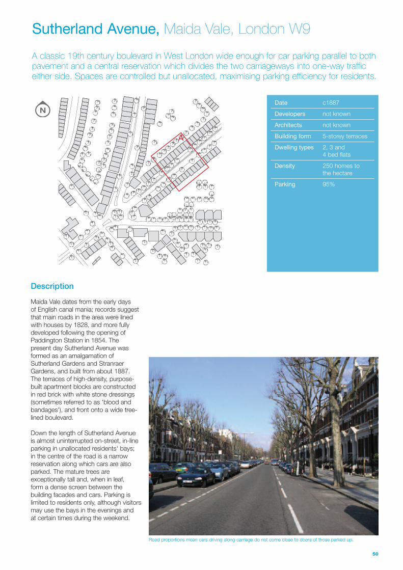
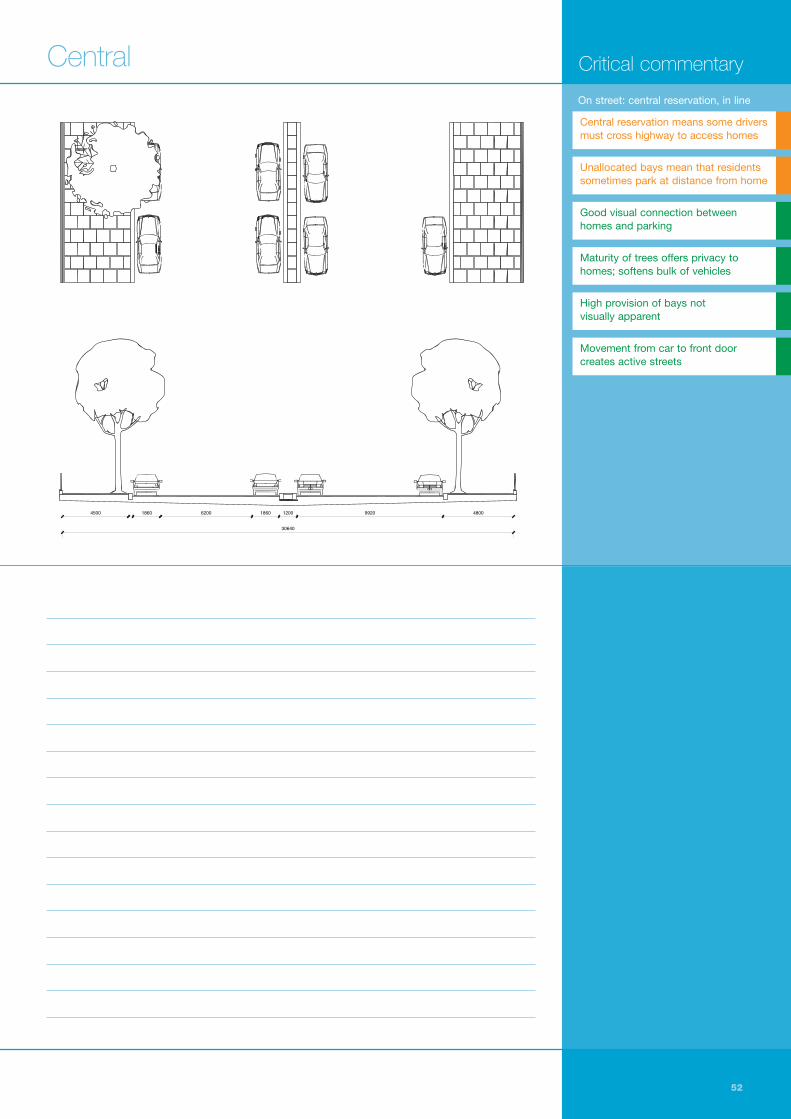
A classic 19th century boulevard in West London wide enough for car parking parallel to bothpavement and a central reservation which divides the two carriageways into one-way trafficeither side. Spaces are controlled but unallocated, maximising parking efficiency for residents.
Road proportions mean cars driving along carriage do not come close to doors of those parked up.
Date c1887
Developers not known
Architects not known
Building form 5-storey terraces
Dwelling types 2, 3 and 4 bed flats
Density 250 homes tothe hectare
Parking 95%
Sutherland Avenue, Maida Vale, London W9
50
Description
Maida Vale dates from the early days of English canal mania; records suggestthat main roads in the area were linedwith houses by 1828, and more fullydeveloped following the opening ofPaddington Station in 1854. The present day Sutherland Avenue wasformed as an amalgamation ofSutherland Gardens and StranraerGardens, and built from about 1887.The terraces of high-density, purpose-built apartment blocks are constructed in red brick with white stone dressings(sometimes referred to as 'blood andbandages'), and front onto a wide tree-lined boulevard.
Down the length of Sutherland Avenue is almost uninterrupted on-street, in-lineparking in unallocated residents' bays; in the centre of the road is a narrowreservation along which cars are alsoparked. The mature trees areexceptionally tall and, when in leaf, form a dense screen between thebuilding facades and cars. Parking islimited to residents only, although visitorsmay use the bays in the evenings and at certain times during the weekend.
A

Five storeys of purpose-built apartments mean good surveillance onto cars. Pavement in central reservation is an island for pedestrians.
51 English Partnerships
Sutherland Avenue, Maida Vale, London W9A On street: central reservation, in line with pavement
One way lets drivers park safely to left or right. Shadows from trees hint at shade in summer.
Cross-reference
See also pages 31, 47, 73 and 125
Notes
52
Critical commentaryCentral
62004500 1860 1860 1200 9920 4800
30640
62004500 1860 1860 1200 9920 4800
30640
Unallocated bays mean that residentssometimes park at distance from home
Good visual connection betweenhomes and parking
Maturity of trees offers privacy tohomes; softens bulk of vehicles
High provision of bays not visually apparent
On street: central reservation, in line
Central reservation means some driversmust cross highway to access homes
Movement from car to front doorcreates active streets

1. From about 70 homes to the hectare it becomes impossible to accommodate all car parking on street unless provision is considerably reduced
2. Combine on street parking types with other frontage access parking types and some mews
3. Mechanical and other special parking types (multi-storey, underground and undercroft) are economicin central locations at high densities (see page 11)
4. Do not leave these special parking types exposedto the street at ground level. They form a blank edge to the street and so are best wrapped or sleeved by buildings
5. Off plot parking spaces need to be well lit with a safe route between space and home that is accessible to all
6. Mechanical parking needs a back-up plan
7. Success in parking design relies on careful detailing, lighting and landscaping
Central: rules of thumb
53 English Partnerships


