Download - Brooklyn and Altona North
Brooklyn and Altona North July 2021 Update

Draft LAMP Paper 2
Executive Summary The Brooklyn and Altona North Local Area Movement Plan (LAMP) identifies issues and
opportunities relating to the safety, connectivity, amenity and accessibility within the local
road and cyclist network across all modes of transport. This draft LAMP report includes
proposed actions in response to key traffic and transport issues that have been identified in
the LAMP Issues Paper to be found on Council’s ‘Participate’ page. This Issues Paper was
developed following community consultation and review of various strategic plans and
operational data. In summary and specifically within the Brooklyn and Altona North areas
the following issues have been identified:
• Access into Millers Road heading south from Brooklyn
• Gaps in shared path network along the railway line
• Pedestrian and cyclist safety issues
• Lack of north-south pedestrian connections over Blackshaws Road
• Cyclist safety along Kororoit Creek Road
• Pedestrian movements around activity centres and reserves
• Traffic speeds within the study area
In response to the issues identified throughout the preliminary investigations and the
discussions that have been undertaken with the local community and other stakeholders, the
following overarching objectives of the LAMP were developed:
• Improve the safety of cyclists and pedestrians
• Improve pedestrian and cyclist connectivity, particularly east-west through the study area
• Design a transport network that allocates road space to the most desirable transport
mode in a way that encourages the efficient movement of people
• Improve the amenity and connectivity around activity centres within the study area
In response to the identified issues and the LAMP objectives, the following key actions have
been developed for further consideration:
• Complete the shared path network along Ross Street between Millers Road and Maddox
Road
• Cycling network improvements by completing gaps in east-west priority route including
along Duosa Road and Marigold Avenue
• Cyclist safety initiatives including Kororoit Creek Road and Millers Road ‘pop up bicycle
lane’ trials as well as a bicycle bypass of the roundabout of Millers Road / Kororoit Creek
Road
• Pedestrian improvements – Missing connections are addressed as well as the general
quality and safety of the pedestrian infrastructure
• 40km/h zones – Area-wide 40km/h zones are proposed within residential areas to
improve vehicular, pedestrian and cyclist safety
• Traffic management – Local streets with identified speed or through traffic issues have
been proposed to be treated with varying types of traffic management

Draft LAMP Paper 3
The draft actions and initiatives as out lined in this report have been developed and released
back to the Hobsons Bay community and key stakeholders for the purposes of seeking
further input, and incorporates changes resulting from community engagement undertaken in
May and June 2021, detailed in the Northern Package Engagement Report (July 2021).
This document should be read in conjunction with the supporting maps which locate and
reference the specific recommendations. Furthermore, Council encourages the community
to provide input to any missed or additional suggested recommendations to be considered
further.

Draft LAMP Paper 4
Table of Contents 1. Introduction .................................................................................................................... 5
2. Issues and Objectives Identification ............................................................................... 6
2.1. Issues Paper ........................................................................................................... 6
2.2. Community Engagement ......................................................................................... 8
2.2.1. Participate Feedback ....................................................................................... 8
2.2.2. Stakeholder Engagement................................................................................. 8
2.3. Issues Summary ..................................................................................................... 9
3. Local Area Movement Plans ........................................................................................ 10
3.1. LAMP Objectives .................................................................................................. 10
3.2. Brooklyn and Altona North Road User Hierarchy .................................................. 10
3.3. Proposed Actions .................................................................................................. 11
3.3.1. Sustainable and Active Transport .................................................................. 11
3.3.2. Vehicular Traffic ............................................................................................. 18
4. Next Steps in Process .................................................................................................. 21

Draft LAMP Paper 5
1. Introduction
The Brooklyn and Altona North Local Area Movement Plan (LAMP) considers the planning
and management of the current road and transport networks across all modes of transport;
walking, cycling, public transport, freight, heavy and private vehicles. The key purpose of
the LAMP is to identify opportunities to improve safety, connections, amenity and
accessibility for all, primarily on the local network. It is important to note that the interface of
the local road and shared trail network with the arterial network is a key factor in ensuring a
safe and effective network. While the LAMP does not plan for the arterial network, the
LAMPs consider the entire network. The LAMP is aligned with the objectives of the following
two key Council policy documents.
The Hobsons Bay City Council Plan (2017-2021), developed in conjunction with the
Hobsons Bay 2030 Community Vision, contains the following actions under the goal of
creating a well-designed, maintained and environmentally sustainable place:
“Work with all levels of government and other stakeholders to improve our
transport network and to address gaps and capacity in public transport, our
roads, footpaths and cycling routes.”
The Hobsons Bay Integrated Transport Plan 2017-2030 (ITP) sets a long-term vision for
integrated transport in Hobsons Bay, and provides a set of overarching principles to guide
Council’s transport planning, programs, policies, operations, investment and decision
making. It has been informed by extensive stakeholder and community engagement and will
also underpin Council’s platform for advocacy and collaboration. The vision is:
“an integrated, innovative and equitable transport system, providing a range of
sustainable, efficient, accessible and safe ways for people and goods to reach
their destination.”
The key guiding principles are integration, equity, efficiency, sustainability and
innovation.
The ITP identified opportunities to draw on Hobsons Bay’s Network Operating Plan to
establish priority mode networks across the local road system, complemented by a
rolling program of traffic management projects to address local traffic issues, promote
public transport usage and integration through improved walking and cycling
connections, as well as urban design and place making projects based around public
transport infrastructure.
Projects are currently being developed within the study area including the West Gate
Tunnel Project, Hobsons Bay Transport Planning Studies (HBTPS), Precinct 15, 16
and 17 as well as a number of Blackspot projects and other Council capital works.
The Brooklyn and Altona North study area is shown below in Figure 1.

Draft LAMP Paper 6
Figure 1: Study Area
The combined Brooklyn and Altona North LAMP is one of the LAMP areas investigated as a
part of the Hobsons Bay Transport Planning Study. LAMPs for Newport, Williamstown
North, Spotswood and South Kingsville have also been developed. As a part of the West
Gate Tunnel Environmental Effects Statement, the Victorian State Government committed to
jointly, with Hobsons Bay City Council, carry out a detailed traffic study to consider the full
impacts of the West Gate Tunnel Project and the Level Crossing Removal Projects on the
residents of Hobsons Bay.
Brooklyn includes industrial land uses to the east and west of the study are with residential
land uses in the centre to the west of Millers Road. The Federation Trail runs through the
study area and segregates this area of Brooklyn into two parcels. Altona North generally
contains two (2) distinct areas, with industrial uses located to the west of Kororoit Creek and
the residential uses to the east.
2. Issues and Objectives Identification
2.1. Issues Paper
Issues Papers have been developed which identify the current issues and gaps within the
Brooklyn and Altona North areas. These issues papers were established from:
• A review of strategic plans
• Operational data
• Submissions received from community engagement
• Workshops with key stakeholders (Department of Transport, Port of Melbourne, Public
Transport Victoria, VicTrack, Transport for Victoria, Bicycle Victoria and resident groups)
The Issues Papers reviewed currently committed works from both the State Government and
Hobsons Bay City Council including the following projects:
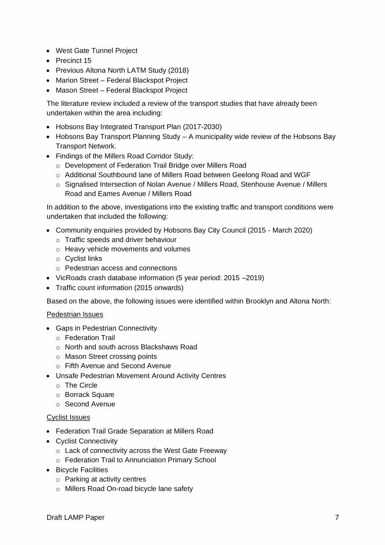
Draft LAMP Paper 7
• West Gate Tunnel Project
• Precinct 15
• Previous Altona North LATM Study (2018)
• Marion Street – Federal Blackspot Project
• Mason Street – Federal Blackspot Project
The literature review included a review of the transport studies that have already been
undertaken within the area including:
• Hobsons Bay Integrated Transport Plan (2017-2030)
• Hobsons Bay Transport Planning Study – A municipality wide review of the Hobsons Bay
Transport Network.
• Findings of the Millers Road Corridor Study:
o Development of Federation Trail Bridge over Millers Road
o Additional Southbound lane of Millers Road between Geelong Road and WGF
o Signalised Intersection of Nolan Avenue / Millers Road, Stenhouse Avenue / Millers
Road and Eames Avenue / Millers Road
In addition to the above, investigations into the existing traffic and transport conditions were
undertaken that included the following:
• Community enquiries provided by Hobsons Bay City Council (2015 - March 2020)
o Traffic speeds and driver behaviour
o Heavy vehicle movements and volumes
o Cyclist links
o Pedestrian access and connections
• VicRoads crash database information (5 year period: 2015 –2019)
• Traffic count information (2015 onwards)
Based on the above, the following issues were identified within Brooklyn and Altona North:
Pedestrian Issues
• Gaps in Pedestrian Connectivity
o Federation Trail
o North and south across Blackshaws Road
o Mason Street crossing points
o Fifth Avenue and Second Avenue
• Unsafe Pedestrian Movement Around Activity Centres
o The Circle
o Borrack Square
o Second Avenue
Cyclist Issues
• Federation Trail Grade Separation at Millers Road
• Cyclist Connectivity
o Lack of connectivity across the West Gate Freeway
o Federation Trail to Annunciation Primary School
• Bicycle Facilities
o Parking at activity centres
o Millers Road On-road bicycle lane safety

Draft LAMP Paper 8
Traffic Issues
• Access in/out of Brooklyn local streets
• Local Street – traffic speed and through traffic volumes
• Congestion on the arterial road network
• Traffic Safety
o The Circle
o Langshaw Reserve
o Burgess Street / Paw Paw Road
• Truck Issues
o Local street through traffic
o Truck parking on Paw Paw Avenue, Pinnacle Road and Toll Drive
2.2. Community Engagement
2.2.1. Participate Feedback
The Issues Paper (including supporting documents) was released via Council’s online
engagement ‘Participate’ portal seeking input to three (3) different aspects of the study area,
mainly:
• ‘Love’ – What do you love about the local area?
• ‘Change’ – What would you change about Brooklyn and Altona North?
• ‘Idea’ – What ideas do you have for the local area?
A total of 312 responses were received through this online portal which have been reviewed
and collated into the following key themes:
• Pedestrian and cyclist connectivity and safety along Millers Road and Kororoit Creek
Road
• Gaps in the cycling and shared path network including from Federation Trail, Millers
Road, Kororoit Creek Trail and Kororoit Creek Road
• Traffic speed and safety along Mason Street
• Through traffic and truck traffic within the study area
2.2.2. Stakeholder Engagement
Meetings were held with stakeholders, including representatives from the Department of
Transport and Port of Melbourne with the feedback received contributing to the development
of the existing issues within the Brooklyn and Altona North areas.
Meetings were also held with resident groups with the key discussion items summarised as
follows:
Brooklyn Residents Action Group (BRAG)
• Millers Road
o Truck ban onto West Gate Freeway at Millers Road
o Improvements to bicycle and pedestrian safety along Millers Road
o Millers Road upgrades from Geelong Road to West Gate Freeway
o Review signal phasing at Millers Road / West Gate Freeway to clear intersection
o Pedestrian operated signals at Primula Avenue, Paringa Road and Beevers Street
Draft LAMP Paper 9
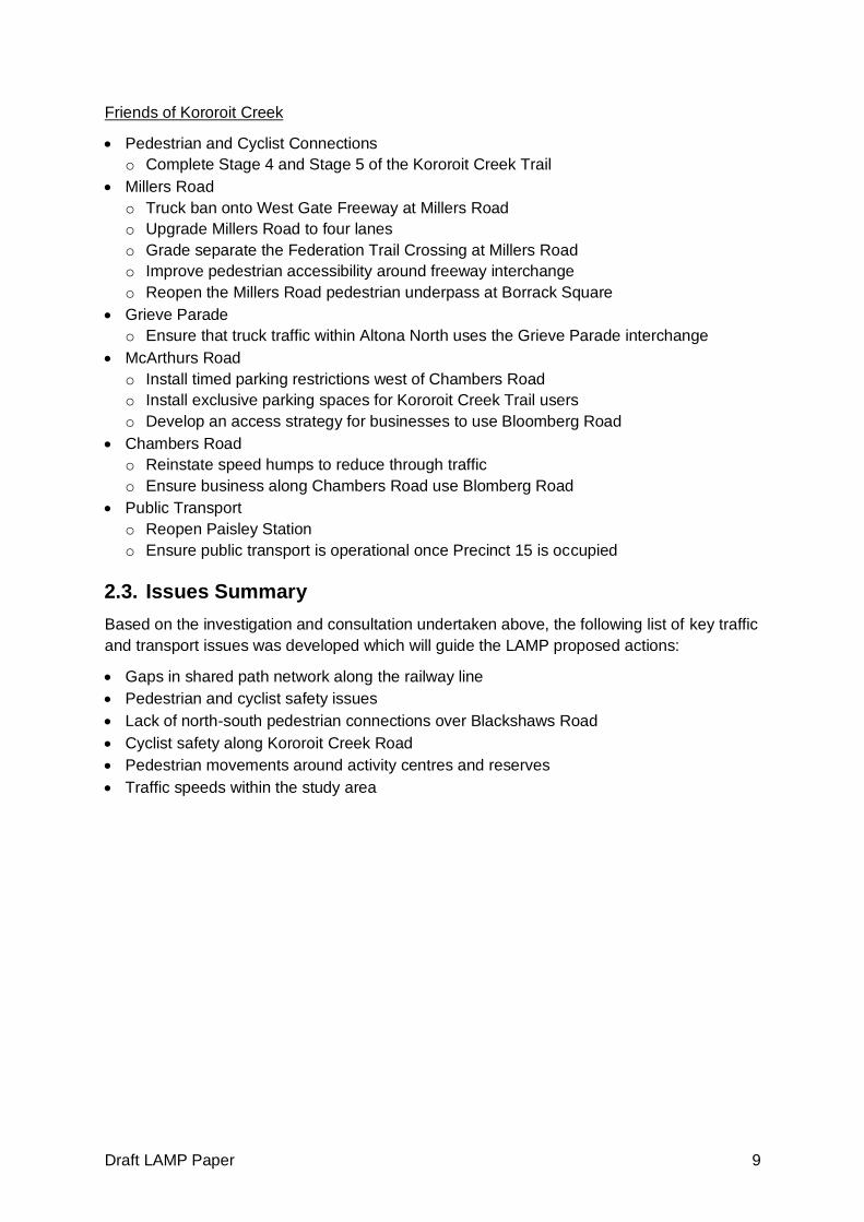
Friends of Kororoit Creek
• Pedestrian and Cyclist Connections
o Complete Stage 4 and Stage 5 of the Kororoit Creek Trail
• Millers Road
o Truck ban onto West Gate Freeway at Millers Road
o Upgrade Millers Road to four lanes
o Grade separate the Federation Trail Crossing at Millers Road
o Improve pedestrian accessibility around freeway interchange
o Reopen the Millers Road pedestrian underpass at Borrack Square
• Grieve Parade
o Ensure that truck traffic within Altona North uses the Grieve Parade interchange
• McArthurs Road
o Install timed parking restrictions west of Chambers Road
o Install exclusive parking spaces for Kororoit Creek Trail users
o Develop an access strategy for businesses to use Bloomberg Road
• Chambers Road
o Reinstate speed humps to reduce through traffic
o Ensure business along Chambers Road use Blomberg Road
• Public Transport
o Reopen Paisley Station
o Ensure public transport is operational once Precinct 15 is occupied
2.3. Issues Summary
Based on the investigation and consultation undertaken above, the following list of key traffic
and transport issues was developed which will guide the LAMP proposed actions:
• Gaps in shared path network along the railway line
• Pedestrian and cyclist safety issues
• Lack of north-south pedestrian connections over Blackshaws Road
• Cyclist safety along Kororoit Creek Road
• Pedestrian movements around activity centres and reserves
• Traffic speeds within the study area
Draft LAMP Paper 10
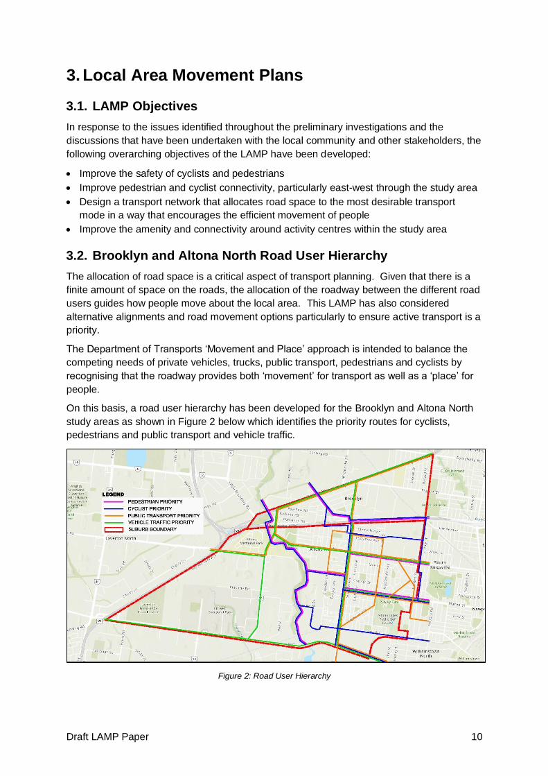
3. Local Area Movement Plans
3.1. LAMP Objectives
In response to the issues identified throughout the preliminary investigations and the
discussions that have been undertaken with the local community and other stakeholders, the
following overarching objectives of the LAMP have been developed:
• Improve the safety of cyclists and pedestrians
• Improve pedestrian and cyclist connectivity, particularly east-west through the study area
• Design a transport network that allocates road space to the most desirable transport
mode in a way that encourages the efficient movement of people
• Improve the amenity and connectivity around activity centres within the study area
3.2. Brooklyn and Altona North Road User Hierarchy
The allocation of road space is a critical aspect of transport planning. Given that there is a
finite amount of space on the roads, the allocation of the roadway between the different road
users guides how people move about the local area. This LAMP has also considered
alternative alignments and road movement options particularly to ensure active transport is a
priority.
The Department of Transports ‘Movement and Place’ approach is intended to balance the
competing needs of private vehicles, trucks, public transport, pedestrians and cyclists by
recognising that the roadway provides both ‘movement’ for transport as well as a ‘place’ for
people.
On this basis, a road user hierarchy has been developed for the Brooklyn and Altona North
study areas as shown in Figure 2 below which identifies the priority routes for cyclists,
pedestrians and public transport and vehicle traffic.
Figure 2: Road User Hierarchy
Draft LAMP Paper 11
‘Priority’ routes do not mean that the designated mode receives exclusive use of the
roadway, it intends to provide a higher level of amenity for the designated mode within the
available road space before providing for all other modes.
These priority routes and the road user hierarchy will be used as a guide to the proposed
actions for the Brooklyn and Altona North draft LAMPs.
3.3. Proposed Actions
A review of the local road networks within Brooklyn and Altona North have identified
opportunities to improve the traffic and transport conditions within the study area.
Several items have been shown on the draft LAMP that have been developed separately to
the LAMP process (such as Planning Scheme Amendments, permit conditions or other
Council projects) for reference.
The following section outlines the recommended actions and initiatives that are being
proposed for Brooklyn and Altona North in order to address the issues.
3.3.1. Sustainable and Active Transport
Sustainable and active transport includes pedestrians, cyclists, public transport and other
green travel modes. Not only is promoting sustainable and active travel modes good for the
environment, it improves health and wellbeing as well as improving the amenity of the local
area by reducing vehicle trips.
Pedestrian Connectivity
The previous phases of the LAMP process identified several key gaps in pedestrian
connectivity, particularly to key activity generators.
Blackshaws Road forms a major east-west traffic link across the municipality, however, has
a serious lack of north-south crossing facilities for pedestrians. On this basis, it is proposed
to install a pedestrian refuge within the Altona North section of Blackshaws Road at Delphin
Avenue and undertake a safety review at Begonia Avenue and recommend improvements to
existing crossing facility.
Feedback from the community highlighted that pedestrian accessibility around Borrack
Square was deficient, particularly along Duke Street. On this basis, it is proposed to
construct zebra crossings at key locations along Duke Street, including adjacent to the post
office and across Duke Street at McArthurs Road. In addition, it is recommended to
undertake upgrades to the existing pedestrian crossings within Borrack Square.
In addition to the above items, it was recognised that accessibility into the park along Fifth
Avenue is difficult and as such it is recommended to install a pram ramps around Child Care
Centre and park to improve pedestrian connectivity across the surrounding roads.
It has been highlighted that pedestrian connectivity from Brooklyn to locations south of West
Gate Freeway is deficient with poor footpath quality and missing pram ramps to key
locations south of the freeway, particularly to Altona Gate Shopping Centre and Crofts
Reserve. On this basis, it is recommended to undertake footpath enhancements and a pram
ramp review from the Rosala Avenue overpass to these two key pedestrian locations.
Feedback received from the community identified pedestrian connectivity issues along Mills
Street particularly adjacent to Paisley Park and across to McIntosh Road. On this basis, it is

Draft LAMP Paper 12
recommended to construct a footpath along the eastern side of Mills Street and a pedestrian
refuge in the vicinity of McIntosh Road to facilitate pedestrian movements across the road.
Pedestrian Safety
A review of the casualty crash history within Brooklyn and Altona North has identified two
intersections along Millers Road that have identified pedestrian crash patterns. There is a
pattern of vehicles turning right out of both Marigold Avenue and Mason Street into Millers
Road impacting pedestrian crossing Millers Road, as detailed in the image below.
Figure 3: Example Pedestrian Crash Pattern - Mason Street / Millers Road
On this basis, it is recommended to amend the signal phasing to separate pedestrian
movements from right turning vehicles.
Safe Travel to School Program
Council is committed to encouraging active travel to school through walking, cycling or
scooting, recognising the benefits this brings to health, wellbeing as well as safety and
congestion around schools. Council works with local schools to improve infrastructure to
address safety barriers which may prevent students using active travel. This includes traffic
calming works around schools to lower speeds, improved crossings, designated pick-up and
drop-off areas, one-way streets, lowered speed limits, and footpath decals to highlight safe
routes.
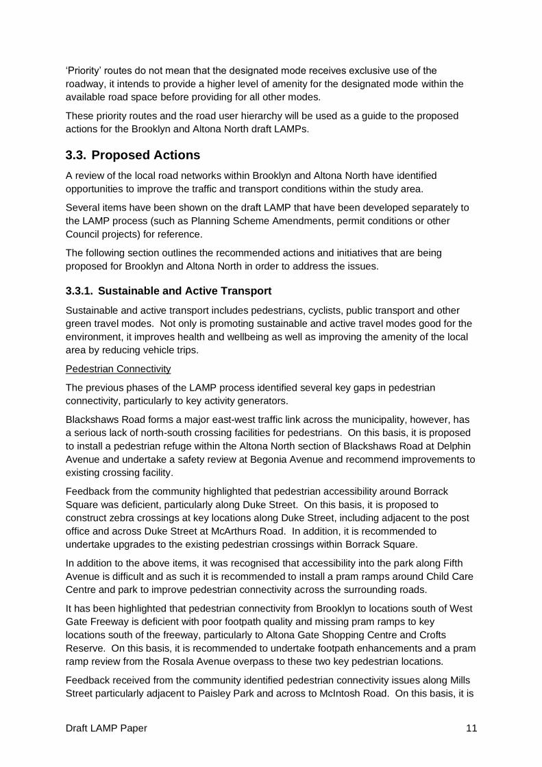
The proposed pedestrian treatments are shown below in Figure 4 and outlined in Table 1.
Draft LAMP Paper 13
Figure 4: Pedestrian Connectivity
Table 1: Pedestrian Connectivity Treatments
Location Treatment
Pedestrian Connectivity
A Blackshaws Road at Delphin Avenue and Begonia Avenue
Construct pedestrian refuge at Delphin Avenue and undertake safety review at crossing of Begonia Avenue
B Borrack Square
at Duke Street
Construct zebra crossings adjacent to the Australia Post and at McArthurs Road and upgrade existing zebra crossings within Borrack Square
C WJ Irwin Reserve Install pram ramps around Child Care Centre and reserve
D Brooklyn to Crofts Reserve Freemans Road and Gadsen Street
Undertake footpath enhancements and pram ramp review as well as wayfinding to improve pedestrian connection between Brooklyn and Crofts Reserve
E Brooklyn to Altona Gate Chambers Road, Paringa Road, Lee Street, Bond Street, Langshaw Street, Duosa Road
Undertake footpath enhancements and pram ramp review as well as wayfinding to improve pedestrian connection between Brooklyn and Altona Gate
F Mills Street at McIntosh Road
Investigate the installation of a footpath along the eastern side of Mills Street as well as a pedestrian refuge at McIntosh Road
Pedestrian Safety
G Millers Road / Marigold Ave Investigate fully controlled right turns out of Marigold Avenue to separate pedestrian and vehicle movements

Draft LAMP Paper 14
Location Treatment
H Millers Road / Mason Street Investigate fully controlled right turns out of Mason Street to separate pedestrian and vehicle movements
I Annunciation Primary School Implement ‘Safer Schools’ program by installing footpath decals and widening and speed management around the school
Shared Path Network
Brooklyn and Altona North currently have a significant shared path network that provides off-
road bicycle and pedestrian pathways across the study area. A review of the existing
network, however, found gaps in the network that may dissuade vulnerable users from
walking or riding as an alternative to driving.
On this basis, a 3.0m wide shared path is proposed along Ross Street (north of the railway
line) between Maddox Road and Millers Road / Butler Road.
In addition to the shared path above, Council is to continue to advocate to DoT and the West
Gate Tunnel Project to have the Federation Trail crossing of Millers Road grade separated
as well as to continue to pursue the timely construction of Stage 4 and Stage 5 of the
Kororoit Creek Trail.
Figure 5 below details the shared path proposals.
Figure 5: Shared Path Network Improvements
Table 2: Shared Path Network Improvements
Location Treatment
J Ross Road Railway Parade to Millers Road
Construct 3.0m wide shared path along the north side of the railway from
K Federation Trail at Millers Road
Council is to continue to advocate to DoT and the West Gate Tunnel Project to provide a
Draft LAMP Paper 15
Location Treatment
grade separated crossing for the Federation Trail at Millers Road
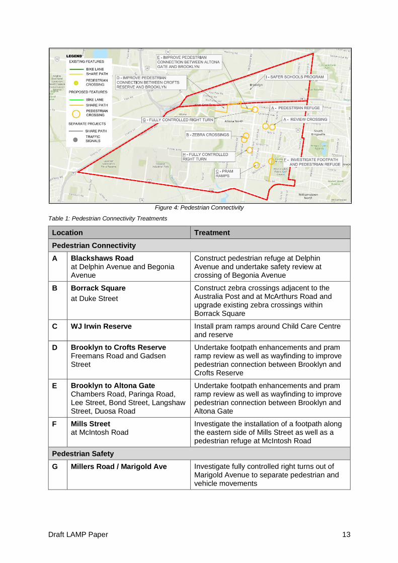
L Kororoit Creek Trail Stage 4 and Stage 5
Council to continue to pursue the construction of Stage 4 and Stage 5 of the Kororoit Creek Trail
Cyclist Improvements
Brooklyn and Altona North include numerous on-road bicycle facilities including dedicated
paths along Kororoit Creek Road, Millers Road and along Mason Street.
The western end of McArthurs Road provides direct access onto the Kororoit Creek Trail.
Given that McArthurs Road is a direct connection to Millers Road it is proposed to provide
on-road bicycle treatment (sharrows) along McArthurs Road to improve cyclist amenity along
this link. An additional connection from Millers Road to the Kororoit Creek Trail is being
proposed via Butler Street, Chambers Road and Barnes Road.
Completion of the major east-west cycling route through Hobsons Bay is a priority with key
linkages located within Altona North. On this basis it is recommended to continue the
cycling route between Millers Road and Precinct 15 by connecting to Beevers Street via a
pathway south of the Terminal Station as shown below in Figure 6. This is also outlined in
the Spotswood and South Kingsville draft LAMP report. Further connections are proposed
from the Rosala Avenue overpass to Millers Road via sharrows located along Chambers
Road and Duosa Road.
Figure 6: Proposed East-West Cyclist Connection (Precinct 15)
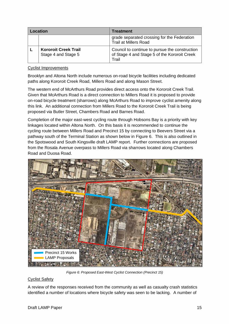
Cyclist Safety
A review of the responses received from the community as well as casualty crash statistics
identified a number of locations where bicycle safety was seen to be lacking. A number of
Precinct 15 Works
LAMP Proposals

Draft LAMP Paper 16
improvements were recommended across numerous locations including green pavement
treatment across intersections and ‘pop up bicycle lanes’.
One area of main concern was the roundabout at Millers Road and Kororoit Creek Road. At
this location it is proposed to advocate to DoT (VicRoads) to construct an off-road bicycle
bypass of this intersection to separate cyclist and vehicle movements.
Figure 7 below details the proposed cycling network improvements.
Figure 7: Cyclist Network Improvements
Table 3: Cyclist Network Improvements
Location Treatment
Cyclist Connectivity
M McArthurs Road Kororoit Creek Trail to Millers Road
Investigate an on-roads bicycle treatment (such as sharrows) to complete connection
N Barnes Road / Chambers Road / Butler Street Millers Road to Kororoit Creek Trail
Provided sharrow connections from Ross Road / Millers Road to Kororoit Creek Trail by providing sharrows along Butler Road, Chambers Road and Barnes Road.
O Chambers Road / Duosa Road Paringa Road to Millers Road
Complete connection from freeway overpass to Millers Road by providing on-road treatment (such as sharrows) along this section of road
P Beevers Street Millers Road to Kyle Road (Continue into Precinct 15)
Provide cycling treatment along Beever Street (including through reserve) to connect Millers Road with Precinct 15
Q Kororoit Creek Road at Racecourse Road
Investigate the feasibility of an additional cyclist crossing of Kororoit Creek Road in the vicinity of Racecourse Road
Draft LAMP Paper 17
Location Treatment
Cyclist Safety
R Millers Road Kororoit Creek Road to West Gate Freeway
Advocate to DoT (VicRoads) to install green pavement treatment along Millers Road across intersections as well as head start boxes
S Millers Road West Gate Freeway to Geelong Road
Investigate the installation of a trial ‘pop-up bicycle lane’ treatment along this section of Millers Road
T Kororoit Creek Road Champion Road to Millers Road
Investigate the installation of a trial ‘pop-up bicycle lane’ treatment
U Millers Road / Kororoit Creek Road
Advocate to DoT (VicRoads) to install an off-road bicycle bypass at this location to improve cyclist safety
Improved Bicycle Facilities
Proposed initiatives to improve the bicycle amenity across Brooklyn and Altona North (as
well as the wider Hobsons Bay area) include:
• Bike maintenance stations to be located at DN Duane Reserve and BayFit Leisure Centre
on Mason Street,
• Bicycle parking to be installed at all reserves and activity centres within the study area,
• Expand the existing HBCC wayfinding strategy for the municipality by identifying the
direction and proximity to major destinations and cycling infrastructure such as the
Federation Trail, and
• Promote mobile apps or updates to the TravelSmart Map for Hobsons Bay
Share Schemes
The usage of car share and bicycle share schemes reduces the resident reliance on motor
vehicle ownership by providing a car/bike for hire on an hourly basis. Share schemes
reduce the reliance on motor vehicles by providing short term use of a car when walking,
cycling or public transport are not feasible.
It is recommended to investigate the adoption of a car share and/or bicycle share scheme
within the municipality through discussions with various share scheme operators.
Public Transport
A review of the public transport conditions across the study area was undertaken in line with
current and future requirements. Feedback received during the community engagement
process noted that there were significant gaps in the public transport network, particularly
within Altona North. On this basis, several initiatives have been developed in an effort to
streamline the public transport network and improve the accessibility to services:
• Advocate to PTV to reopen a train station within Altona North to provide proximate access
to the railway network
• Advocate to PTV to implement additional bus services within Altona North to provide
greater coverage for residents

Draft LAMP Paper 18
3.3.2. Vehicular Traffic
40km/h Zones
To improve the local amenity and safety of Brooklyn and Altona North, it is proposed to
implement 40km/h zones in the residential areas of the study area. Current default speed
limits within urban areas are 50km/h, however reducing this to 40km/h will provide a
significant increase in traffic safety, particularly for vulnerable road users like pedestrians
and cyclists as it results in a reduction in both the incidence and severity of crashes.
In addition to improved safety, lower speed limits encourage more walking and cycling
(which has associated mental and physical health benefits). It is also likely to discourage
non-local through-traffic by increasing travel times marginally through the local streets.
On this basis, 40km/h speed limit zones are proposed as outlined below in Figure 9 and
Table 4.
Table 4: 40km/h Zones
Location Treatment
V Brooklyn between Geelong Road, Millers Road and West Gate Freeway
Area wide 40km/h speed reduction including all local roads.
W Cyclamen between Millers Road, Blackshaws Road, Kyle Road and West Gate Freeway
X Altona North between Millers Road, Blackshaws Road, Melbourne Road and the railway line
Y Altona Gate between Blackshaws Road, Millers Road, West Gate Freeway and Knapp Street
Z Chambers Road between Millers Road, Chambers Road, Cabot Drive, Blackshaws Drive
Traffic Management
Through a review of historical traffic data, previous resident correspondence and the public
consultation period specific areas of concern were identified regarding traffic behaviour.
A small Local Area Traffic Management (LATM) study was developed in 2018 for the area
bounded by Blackshaws Road, Mills Street, Mason Street and Millers Road. The LATM was
in response to numerous enquiries regarding speeding and safety issues within the study
area.
A number of treatments have been proposed as part of this small LATM shown below in
Figure 8.

Draft LAMP Paper 19
Figure 8: Draft LATM Scheme
The above items are currently being consulted on by the local community for feedback with
the outcomes separate to this LAMP study.
On this basis, the traffic management traffic management has been proposed as follows.
Table 5: Traffic Management Proposals
Location Treatment
Brooklyn
AA Marigold Avenue between Millers Road and Kyle Road
Kerb extensions and slow points with street
trees
AB Heather Avenue at Nolan Avenue and Stenhouse Avenue
Construct raised intersection platforms along Heather Avenue at Nolan Avenue and Stenhouse Avenue
AC Millers Road at Eames Avenue/Nolan Avenue
Investigate the construction of traffic signals at Millers Road and Eames Avenue or Nolan Avenue to facilitate traffic movements out of Brooklyn
AD Primula Avenue at Millers Road
Review the intersection of Primula Avenue and Millers Road for visibility of the freeway offramp and creation of a safe right turn into Millers Road
AE Burgess Street at Paw Paw Road
Undertake an intersection remodel by narrowing the Paw Paw Road approaches and installing speed cushions along Burgess Street.

Draft LAMP Paper 20
Location Treatment
AF Eames Avenue
at Millers Road
Review sight distance at this intersection and potentially amend No Stopping restrictions to improve sight lines.
Altona North
AG Chambers Road Monitor traffic conditions and investigate any requirements for traffic management to reduce vehicle speeds
AH McArthurs Road
AI McIntosh Road between Millers Road and Mills Street
Recommend traffic islands or speed cushions to reduce vehicle speeds
A map showing each of the vehicular traffic proposals is provided below in Figure 9.
Figure 9: Vehicular Traffic Proposals
Additional Traffic Initiatives
In addition to the proposals above, other items that have been raised for additional
investigation include:
• Monitor the intersections of Blackshaws Road / New Street and Blackshaws Road /
Hansen Street as Precinct 15 is built to assess whether this intersection needs to be
signalised
• Ongoing monitoring and review of traffic volumes and movements as a result of the
Precinct 15 development
• Investigate the formalisation of Ross Road between Blenheim Road and Mills Street to
provide connectivity through suburb
• Undertake a parking review within Brooklyn (initially Cyprus Avenue) to review parking
proximity to intersections for installation marked parking spaces or yellow ‘No Stopping’
linemarking
• Advocate to DoT (VicRoads) on a new northbound service lane on Millers Road to assist
residential access from Millers Road

Draft LAMP Paper 21
• Hobsons Bay City Council to prepare a Freight Management Plan for Altona North and
Brooklyn
4. Next Steps in Process
This draft LAMP has been updated with the results from the second stage of Community
Engagement and will be made available to residents of Brooklyn and Altona North as well as
other external stakeholders for comment.
Following this final community engagement stage, the LAMPs will be further reviewed and
finalised before going to Council for endorsement.
Issues Paper (complete)
Community Engagement #1 (complete)
Draft LAMP Development (complete)
Community Engagement #2 (complete)
Final LAMP Development (underway)
Council Endorsement


