


Bedford Passenger Rail Station
Feasibility Study and Conceptual Plan
1
EXECUTIVE SUMMARY
In 2014, the Virginia Department of Rail and Public Transportation (DRPT) announced that
Amtrak Route 46 – the Virginia sponsored Amtrak route that originates in Lynchburg, Virginia –
would be extended to Roanoke. Officials in the Bedford area soon learned that DRPT did not
anticipate the train stopping in Bedford which is located on the route between Roanoke and
Lynchburg. This was contrary to the 2008 Virginia State Rail Plan that showed a stop located
in Bedford for its I-81/Route 29 Passenger Rail Project which was the genesis of Amtrak Route
46.
Upon learning this, a group of local officials convened to determine what steps could be taken
to have a train station for Bedford reinstated in the State’s plans. This group, the
Bedford/Franklin Regional Rail Initiative (BFRRI), is comprised of local officials from the Town
of Bedford, Bedford County, Franklin County, the region’s chambers of commerce, local
businesses and private citizens. The BFRRI prepared an analysis demonstrating the benefits
and advantages of locating a train station in Bedford and in the fall of 2015 presented their
findings to DRPT. DRPT indicated that additional analysis was necessary – specifically a rail
patronage estimate and economic benefits analysis was needed. In addition, the development
of a conceptual plan for a Bedford station was needed. In December, 2015 BFRRI secured
local funding to hire a consultant to perform the additional analysis and to help advance the
first phase of the Bedford Station project. The Town of Bedford assumed the lead role for the
advancement of the project.
In January, 2016 the architecture and engineering company Wendel was selected to perform the
work and was engaged to conduct the analysis and to prepare a conceptual plan for Bedford
Station. This report presents the findings of the study.
The rail patronage analysis performed for this study shows that when Route 46 is extended to
originate in Roanoke, ridership on the route at Roanoke and Lynchburg combined will increase by
about 36,000 boardings and alightings each year – from 72,000 up to 108,000. With the
opening of the Roanoke station, about 6,000 trips will be drawn away from Lynchburg to Roanoke
annually but the net gain of 36,000 trips for Route 46 is about a 50% increase in ridership over
current levels. If a station is established in Bedford, ridership at the Roanoke, Bedford and
Lynchburg stations combined will increase to 134,000. This is a gain of 26,000 trips or 24%
beyond what simply extending the train to Roanoke will produce. Opening Bedford station will
draw some patronage away from Lynchburg – about 6,000 trips per year – but will not decrease
ridership at Roanoke. Annual ridership at Bedford Station is predicted to total 32,000 boardings
and alightings. This would place Bedford Station as 13th among Virginia’s 22 Amtrak stations in
terms of annual patronage.

Bedford Passenger Rail Station
Feasibility Study and Conceptual Plan
2
A preferred site for the Bedford Station was selected in an analysis previously performed by
BFRRI. The preferred site located north of the Town of Bedford Municipal Building at the
intersection of Court Street and Plunkett Street was examined closely in this study. Our
analysis showed that the preferred site will support the proposed project with no significant
obstacles. The exact location of the platform and drop off areas will need to be discussed
with the Town of Bedford Electric Department to ensure acceptability of the positioning of
the station in relation to an adjacent substation and an above ground transmission line. An
environmental analysis of the proposed site revealed no negative impacts. It is essential
that the proposed site for Bedford Station must be presented to Norfolk Southern Railroad
for their review and determination of the suitability of the site to their freight operations.
This review must be initiated by the Virginia Department of Rail and Public Transportation.
The generally accepted guidance for the development of Amtrak station plans is a document
prepared and published by Amtrak entitled “Amtrak Station Program and Planning
Guidelines”. These guidelines establish design standards and criteria for stations platforms
and the station site, program requirements, station features and amenities, station finishes
and architectural design. The Wendel team used this document to determine the
appropriate size and features for the Bedford Station and then working with the project
sponsors developed a specific program for the Bedford Station. It is proposed that Bedford
Station should be designed in accordance with Amtrak’s guidelines for a Category 3 or
Caretaker Station and that Bedford Station should be constructed in two phases. Included
in the first phase would be a 450 foot long and 14 foot wide rail passenger platform with
shelters and benches, a ticket vending machine, passenger drop off area, a bus bay and a
parking area with 50 parking spaces. If the station proves successful and growing
patronage justifies further improvements to the station, a second phase will be pursued. In
the second phase a station building will be constructed with a passenger waiting area and
restrooms, a second bus bay and additional parking will be provided. The station will not be
staffed by an Amtrak agent but will include an interior waiting facility with restrooms that is
opened, closed and maintained by the Town of Bedford. The size and scope of the station
conceptual design were kept minimal – especially for the first phase – to ensure that the
station will fit at all of the prospective sites and to keep costs down while still providing a
safe, functional and attractive facility. A conceptual level cost estimate was prepared for
constructing phase 1 of the project at the preferred site. The estimate indicates that phase
1 of Bedford Station could be constructed and equipment provided for the facility for
approximately $1.5 million. If the preferred site proves to be unacceptable to Norfolk
Southern and another site is selected, additional site improvements may be required. We
expect that phase 1 of the Bedford Station project could be constructed at other prospective
sites for under $2.0 million.

Bedford Passenger Rail Station
Feasibility Study and Conceptual Plan
3
In summary, establishing an Amtrak station in the Town of Bedford after Route 46 is
extended to Roanoke will increase ridership in the region by 24% without noticeably
increasing the cost of operating the Route. This will increase the profitability of Northeast
Regional Route 46 which already is considered one of the most successful state sponsored
routes in the nation. The economic impacts on the Bedford area are expected to include an
increase in spending of about $3.4 million per year which will support 9 jobs. The annual
benefits for people in the Bedford area that ride the train will be about $4.5 million per year.
All of this can be achieved with an initial investment of about $2.0 million to construct
Bedford Station without producing negative environmental impacts. The conceptual plans
for the preferred station location show a safe and functional facility which will serve as an
attractive addition to downtown Bedford and a gateway to the Bedford region. Clearly a
solid business case has been established for creating Bedford Station. It is hoped that
presented with this study, the Virginia Department of Rail and Public Transportation will
embrace the project and begin discussions with Norfolk Southern Railroad to evaluate the
suitability of the preferred site for Bedford Station. If the site is not viable to Norfolk
Southern, the other four prospective sites for the station should be reviewed and a suitable
site selected. A site suitable for Norfolk Southern should be selected, DRPT should forward
this report to Amtrak for their review and concurrence and Bedford Station should advance
to design and construction with an opening date as soon as feasible after the extension of
Amtrak Northeast Regional Train 46 to Roanoke.

Bedford Passenger Rail Station
Feasibility Study and Conceptual Plan
4
TABLE OF CONTENTS
List of Figures .............................................................................................................................................. 5
List of Tables ................................................................................................................................................ 6
INTRODUCTION ............................................................................................................................................ 7
BACKGROUND ............................................................................................................................................. 7
BEDFORD RAIL PATRONAGE REPORT ........................................................................................................ 9
Methodology ............................................................................................................................................ 9
Model Structure ..................................................................................................................................... 10
Study Area Geography ........................................................................................................................... 11
Network and Service Characteristics ................................................................................................... 11
Demographic Data ................................................................................................................................ 13
Base Travel Market Data ...................................................................................................................... 14
Forecast Results .................................................................................................................................... 14
Comparison of Anticipated Bedford Station Patronage to Other Virginia Amtrak Stations .............. 16
NEEDS ASSESSMENT FOR THE BEDFORD STATION ............................................................................... 19
Facility Program ..................................................................................................................................... 19
Facility Sizing ......................................................................................................................................... 22
SITE SELECTION FOR THE BEDFORD STATION ........................................................................................ 24
SITE EVALUATION FOR THE BEDFORD STATION ...................................................................................... 26
Civil Narrative ......................................................................................................................................... 26
Existing Site Conditions ......................................................................................................................... 26
FEMA Floodplain Considerations .......................................................................................................... 27
Zoning ..................................................................................................................................................... 27
Demolition .............................................................................................................................................. 27
Roadway / Parking / Pedestrian Access Improvements..................................................................... 28
Utility Systems ....................................................................................................................................... 28
Communications Service ...................................................................................................................... 28
Water ...................................................................................................................................................... 29
Sanitary Sewer ....................................................................................................................................... 29
Storm Sewer .......................................................................................................................................... 30
Stormwater Management ..................................................................................................................... 30
ENVIRONMENTAL IMPACT OF THE PROPOSED BEDFORD STATION ...................................................... 31
Approach to Environmental Review ..................................................................................................... 31
Site Description ..................................................................................................................................... 34
Current Land Uses ................................................................................................................................. 34
Summary of Potential Impacts ............................................................................................................. 35
ECONOMIC IMPACT OF THE PROPOSED BEDFORD STATION ................................................................. 38

Bedford Passenger Rail Station
Feasibility Study and Conceptual Plan
5
Economic Benefit of Initial Investment ................................................................................................ 39
Economic Impact of Bedford Station Ongoing Operations ................................................................. 39
Bedford Station User Benefits .............................................................................................................. 41
Fiscal Impact for State and Local Governments ................................................................................. 42
CONCEPTUAL PLANS FOR THE BEDFORD STATION ................................................................................ 43
Phase 1 .................................................................................................................................................. 44
Phase 2 .................................................................................................................................................. 45
Appendix I: Bedford Rail Patronage Report – AECOM
Appendix II: Town of Bedford – Passenger Rail Station Programming Questions
Appendix III: Site Evaluation – Draper Aden Associates
Appendix IV: Environmental Impact Review – Draper Aden Associates
Appendix V: The Economic Impact of the Proposed Bedford Station in the Bedford Region –
Chmura Economics & Analytics
Appendix VI: Opinion of Probable Construction Costs – Wendel
LIST OF FIGURES
Figure 1: Bedford Study Area ...................................................................................................................11
Figure 2: Highway Network ......................................................................................................................12
Figure 3: Amtrak Service in Virginia ........................................................................................................17
Figure 4: Amtrak Station Classification and Features Matrix ...............................................................22
Figure 5: Sites Evaluated for the Location of Bedford Station ..............................................................25
Figure 6: Environmental Review Site Location Map ..............................................................................32
Figure 7: Environmental Review Site Detail Map ...................................................................................33
Figure 8: Bedford Station Conceptual Site Plan - Phase 1 ....................................................................47
Figure 9: Bedford Station Conceptual Site Plan - Phase 2 ....................................................................48
Figure 10: Bedford Station Conceptual Image - Phase 1 Aerial View ..................................................49
Figure 11: Bedford Station Conceptual Image - Phase 1 Approach to the Platform from the West 50
Figure 12: Bedford Station Conceptual Image - Phase 2 Aerial View ..................................................51
Figure 13: Bedford Station Conceptual Image - Phase 2 Approach to the Station from the West ...52
Figure 14: Bedford Station Conceptual Image - Phase 2 Approach to the Station from the East ....53
Figure 15: Bedford Station Conceptual Image - Phase 2 Platform View .............................................54

Bedford Passenger Rail Station
Feasibility Study and Conceptual Plan
6
LIST OF TABLES
Table 1: Summary of Socio-Economic Data ...........................................................................................13
Table 2: Summary of Estimated Annual Person Trips by Purpose for Major Markets ........................14
Table 3: Annual Rail Boardings and Alightings for Existing Route .......................................................15
Table 4: Annual Rail Boardings/Alightings for Roanoke Extension without Bedford Station ............15
Table 5: Annual Rail Boardings/Alightings for Roanoke Extension with Bedford Station .................15
Table 6: Annual Amtrak Boardings and Alightings at Virginia Stations ...............................................18
Table 7: Bedford Station Site Rankings ..................................................................................................26
Table 8: Summary of Potential Impacts .................................................................................................36
Table 9: One-time Economic Impact from Bedford Station Initial Investment ...................................39
Table 10: Annual Economic Impact of Bedford Station Operation (2019) ..........................................40
Table 11: Estimated Annual User Benefits ($Million 2019) ..................................................................42
Table 12: Tax Revenue from Bedford Station ........................................................................................43
Table 13: Conceptual Level Construction Estimate for Phase 1...........................................................45

Bedford Passenger Rail Station
Feasibility Study and Conceptual Plan
7
INTRODUCTION
The Town of Bedford has engaged Wendel Architects and Engineers
(Wendel) to conduct a feasibility study and to prepare a conceptual
plan for the construction of an Amtrak station in the downtown area.
The Bedford Station project seeks to bring passenger rail service back
to the Town of Bedford shortly after the initiation of passenger rail
service to Roanoke. The Virginia Department of Rail and Public
Transportation (DRPT) has indicated that Amtrak service to Roanoke
should begin in the fall of 2017. The Bedford Station project will be conducted in two phases. The
first phase includes a feasibility and conceptual design followed by final design phase. The second
phase will be construction of the project. This report represents the first tasks in phase one of the
project. This report will be submitted to DRPT as documentation to support an application from the
Town of Bedford seeking funding to pay for the final design for the Bedford Station Project – the
second task for phase one of the project. The Town is seeking funding support from DRPT’s Intercity
Passenger Rail Operating and Capital (IPROC) grant program.
BACKGROUND
In 2014 and shortly after the Virginia Department of Rail and Public Transportation (DRPT)
announced the extension to Roanoke of its state sponsored Amtrak route that originates in
Lynchburg, Virginia officials in the Bedford area learned that no stop for the service was being
planned for Bedford. This was contrary to the 2008 Virginia State Rail Plan that showed a stop
anticipated for Bedford for its I-81/Route 29 Passenger Rail Project.
Upon learning this, a group of local officials convened to determine what steps could be taken to
have a train station for Bedford reinstated in the State’s plans. This group, the Bedford/Franklin
Regional Rail Initiative (BFRRI), is comprised of local officials from the Town of Bedford, Bedford
County, Franklin County, the region’s chambers of commerce, local businesses and private
citizens. The BFRRI prepared an analysis demonstrating the benefits and advantages of locating
a train station in Bedford and in the fall of 2015 presented their findings to DRPT. DRPT
indicated that additional analysis was necessary – specifically a rail patronage estimate and
economic benefits analysis was needed. In addition, the development of a conceptual plan for a
Bedford station was needed. In December, 2015 BFRRI secured $73.5K in local funding to hire
a consultant to perform the additional analysis and to help advance the first phase of the
Bedford Station project. The Town of Bedford assumed the lead role for the advancement of the
project.

Bedford Passenger Rail Station
Feasibility Study and Conceptual Plan
8
In January, 2016 the architecture and engineering company Wendel was selected to perform the
work and was engaged to carry out a study that includes the following five tasks:
Task 1 – Project Initiation and Rail Patronage Study: The first part of this task is to
convene a meeting of the project stakeholders and discuss the Town of Bedford’s desires
for a train station and the roles and responsibilities of the Wendel Team and Stakeholders.
A study of rail patronage at the Bedford station will be undertaken. The Wendel Team will
produce an accurate ridership projection for the Bedford station with a high degree of
confidence that it will match Amtrak’s own projection, utilizing a national intercity rail
model developed by AECOM for corridor analysis, calibrated to match the base Amtrak
ridership data for the Washington-Lynchburg existing service. The rail patronage study will
include passenger rail ridership forecasts for the proposed Bedford station, along with the
proportion of ridership diverted from Roanoke or Lynchburg stations. This patronage study
will be sent to Amtrak for their review and validation.
Task 2 – Facility Needs Assessment: Working closely with the Town of Bedford, and other
stakeholders to include DRPT, Amtrak and Norfolk Southern, Wendel will identify the
current and future services that will be accommodated at the train station. Based on the
activities that will take place at the center and the types and levels of transportation
services that will utilize the facility, space needs will be defined.
Task 3 – Site Evaluation: The Wendel Team will assess the feasibility of locating the train
station in the area identified by the Town and will examine on-site improvement options to
accommodate the passenger rail station, parking and other improvements. An
environmental review will be conducted for the project.
Task 4 – Conceptual Design: Using the space program developed in Task 2 and the
findings of the site evaluations in Task 3, a conceptual plan will be developed that will
include a site plan, a floor plan, building sections with and elevations, bus
alignment/AutoTURN, and other vehicular interfaces. A conceptual level cost estimate will
be prepared and an economic benefits analysis will be prepared.
Task 5 – Final Report: A report documenting the analyses will be prepared. After the
completion of the feasibility study and conceptual plan, the project will be ready to move into
design work. It is expected that an RFP will be issued by the Town and an A&E firm selected to
conduct the design of the project. The scope of design will include preliminary engineering (30%
level design), design development (30% to 90% design and specifications) and construction
documents (90% to 100% design and permitting.) It will be important that full participation by
DRPT, Norfolk Southern and Amtrak will be secured to help guide the design efforts.

Bedford Passenger Rail Station
Feasibility Study and Conceptual Plan
9
In February, 2016, the Town of Bedford submitted a grant application to DRPT under their
Intercity Passenger Rail Operating and Capital (IPROC) funding program. This application
requested state support for the full architectural and engineering design of Bedford Station. It is
envisioned that upon the acceptance of the project for advancement by DRPT, Norfolk Southern
and Amtrak, a second IPROC application will be submitted in 2017 to support the construction of
the station. The roles and responsibilities of the Town of Bedford, DRPT, Norfolk Southern and
Amtrak in the bidding, construction and equipping of the Bedford Station will be discussed and
finalized during the design process for the station.
BEDFORD RAIL PATRONAGE REPORT
The Bedford Rail Patronage Report was prepared by AECOM – a member of the Wendel Team and a
firm with many years of experience in performing ridership estimating for Amtrak and DRPT. AECOM
prepared the ridership forecast that led to the implementation of Amtrak Northeast Regional Route
46 – the train that originates in Lynchburg, Virginia. The AECOM report is found as Appendix I to this
report.
Methodology
Data collected for this effort included demographic data for the Roanoke Transportation
Management Area, including population and employment for years 2010 and 2040; national
demographic data including population, employment, and income at the Census Division level
for the entire study area for years 2010 and 2013; and total ridership for the Washington-
Lynchburg Amtrak route for FY13 through FY15.
The station ridership was developed using a national intercity rail model developed by AECOM
for corridor analysis of Amtrak’s Northeast Corridor, Southeast Corridor, Florida, and multiple
corridors in the Midwest. The station ridership was calibrated to match the base Amtrak
ridership data provided by the Virginia Department of Rail and Public Transportation (DRPT)
for the Washington-Lynchburg existing service.
The inputs required for this model analysis include:
Geographic zonal system covering the study area
Existing rail and bus ridership
Socio-economic data for the zone system
Highway network connecting all of the zones and rail stations in the study area
Rail schedules for the existing and proposed service
Travel characteristics for auto and rail

Bedford Passenger Rail Station
Feasibility Study and Conceptual Plan
10
Model Structure
The travel demand modeling approach used in this project is based on a model system
developed by AECOM and used in many previous applications to evaluate proposed intercity
and high speed rail services for several states and Amtrak throughout the country. The travel
demand model was originally developed from extensive market research and observed travel
volumes and service characteristics by mode that were conducted/assembled in the various
study corridor markets including Northeast, Southeast, and other regions.
The travel demand forecasting approach utilizes a two-stage model system. The first stage
forecasts the growth in the total number of person trips in each market, and the second stage
predicts the market share of each available mode in each market. Both stages are dependent
on the service characteristics of each mode and the socio-economic characteristics of the
corridor. The key markets addressed in the forecasting model system are defined by
geographical location (i.e., origin-destination zone pair).
The first stage addresses the growth in the total intercity person travel volumes. This includes
“natural” growth and “induced” demand. The “natural” growth component is captured by the
growth in population and employment. The “induced” component is captured by including a
measure of the composite level of modal service expressed in the mode share model- within
the total travel model.
The second stage of the model is the mode share component, which estimates the share of
total person travel by mode. This model considers both auto and rail. Key variables in the
mode share model include:
Line haul travel time
Access/egress time
Travel cost or fare
Frequency of service
Total market-to-market frequencies were scaled based on arrival and departure times of each
train serving the market. These scaling factors are based on the observed performance of
trains in different departure/arrival time slots within rail corridors throughout the US. The rail
utility and market share are determined by the combination of arrival and departure factors
along with the time to the previous and subsequent trains, travel time, cost, access/egress
times and on-time performance.
Bedford Passenger Rail Station
Feasibility Study and Conceptual Plan
11
The mode choice model was calibrated to match the existing corridor by running the time,
cost, and frequency characteristics of the existing Amtrak service, with current population,
employment, and income data. The model parameters were then adjusted until the
forecasted output corresponded with the actual ridership data.
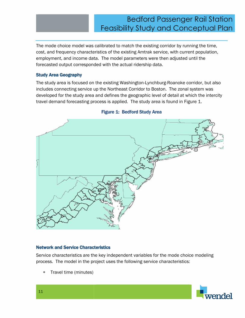
Study Area Geography
The study area is focused on the existing Washington-Lynchburg-Roanoke corridor, but also
includes connecting service up the Northeast Corridor to Boston. The zonal system was
developed for the study area and defines the geographic level of detail at which the intercity
travel demand forecasting process is applied. The study area is found in Figure 1.
Figure 1: Bedford Study Area
Network and Service Characteristics
Service characteristics are the key independent variables for the mode choice modeling
process. The model in the project uses the following service characteristics:
Travel time (minutes)
Bedford Passenger Rail Station
Feasibility Study and Conceptual Plan
12
Travel cost (dollars)
Frequency (rail departures per day)
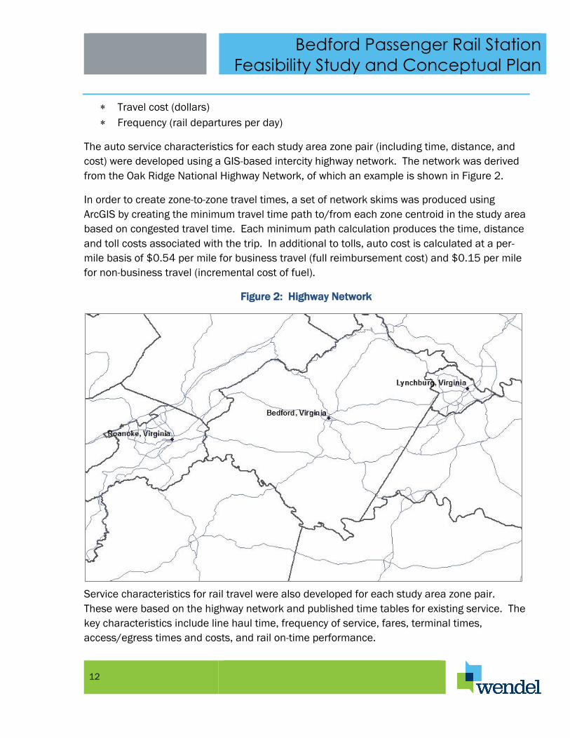
The auto service characteristics for each study area zone pair (including time, distance, and
cost) were developed using a GIS-based intercity highway network. The network was derived
from the Oak Ridge National Highway Network, of which an example is shown in Figure 2.
In order to create zone-to-zone travel times, a set of network skims was produced using
ArcGIS by creating the minimum travel time path to/from each zone centroid in the study area
based on congested travel time. Each minimum path calculation produces the time, distance
and toll costs associated with the trip. In additional to tolls, auto cost is calculated at a per-
mile basis of $0.54 per mile for business travel (full reimbursement cost) and $0.15 per mile
for non-business travel (incremental cost of fuel).
Figure 2: Highway Network
Service characteristics for rail travel were also developed for each study area zone pair.
These were based on the highway network and published time tables for existing service. The
key characteristics include line haul time, frequency of service, fares, terminal times,
access/egress times and costs, and rail on-time performance.
Bedford Passenger Rail Station
Feasibility Study and Conceptual Plan
13
Published Amtrak timetables provided the basis for quantifying the line haul time and
frequency of service. Average rail fares were obtained from previous rail studies in the
corridor. The access/egress times and costs include the time/cost traveling from the origin
zone to the boarding rail station, the time associated with the station (including
waiting/boarding times), and the time/cost traveling from the destination station to the final
destination zone. Access/egress times and costs for travel between zones and stations were
developed using the same network procedure and cost per mile rates described above and
were used for the auto zone-to-zone travel characteristics. The existing Washington to
Lynchburg service has one round-trip per day, and the Roanoke analysis extended this service
to the Roanoke station for the future analysis. Travel times and costs for the extended service
were based on the speed and distance/cost relationships of the other station pairs in the
corridor.
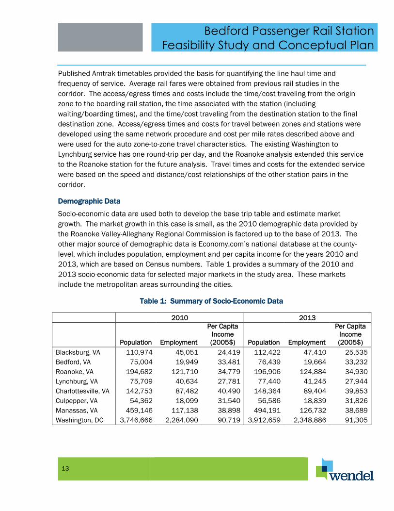
Demographic Data
Socio-economic data are used both to develop the base trip table and estimate market
growth. The market growth in this case is small, as the 2010 demographic data provided by
the Roanoke Valley-Alleghany Regional Commission is factored up to the base of 2013. The
other major source of demographic data is Economy.com’s national database at the county-
level, which includes population, employment and per capita income for the years 2010 and
2013, which are based on Census numbers. Table 1 provides a summary of the 2010 and
2013 socio-economic data for selected major markets in the study area. These markets
include the metropolitan areas surrounding the cities.
Table 1: Summary of Socio-Economic Data
2010 2013
Population Employment
Per Capita
Income
(2005$) Population Employment
Per Capita
Income
(2005$)
Blacksburg, VA 110,974 45,051 24,419 112,422 47,410 25,535
Bedford, VA 75,004 19,949 33,481 76,439 19,664 33,232
Roanoke, VA 194,682 121,710 34,779 196,906 124,884 34,930
Lynchburg, VA 75,709 40,634 27,781 77,440 41,245 27,944
Charlottesville, VA 142,753 87,482 40,490 148,364 89,404 39,853
Culpepper, VA 54,362 18,099 31,540 56,586 18,839 31,826
Manassas, VA 459,146 117,138 38,898 494,191 126,732 38,689
Washington, DC 3,746,666 2,284,090 90,719 3,912,659 2,348,886 91,305
Bedford Passenger Rail Station
Feasibility Study and Conceptual Plan
14
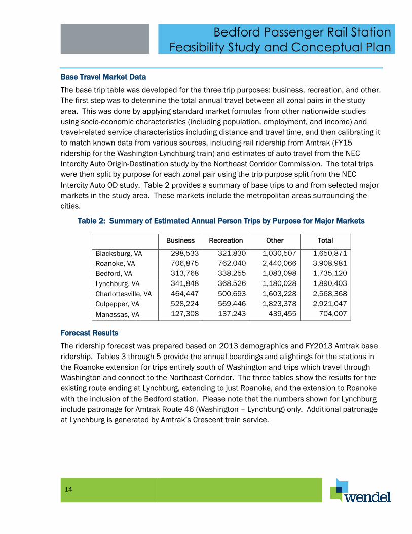
Base Travel Market Data
The base trip table was developed for the three trip purposes: business, recreation, and other.
The first step was to determine the total annual travel between all zonal pairs in the study
area. This was done by applying standard market formulas from other nationwide studies
using socio-economic characteristics (including population, employment, and income) and
travel-related service characteristics including distance and travel time, and then calibrating it
to match known data from various sources, including rail ridership from Amtrak (FY15
ridership for the Washington-Lynchburg train) and estimates of auto travel from the NEC
Intercity Auto Origin-Destination study by the Northeast Corridor Commission. The total trips
were then split by purpose for each zonal pair using the trip purpose split from the NEC
Intercity Auto OD study. Table 2 provides a summary of base trips to and from selected major
markets in the study area. These markets include the metropolitan areas surrounding the
cities.
Table 2: Summary of Estimated Annual Person Trips by Purpose for Major Markets
Business Recreation Other Total
Blacksburg, VA 298,533 321,830 1,030,507 1,650,871
Roanoke, VA 706,875 762,040 2,440,066 3,908,981
Bedford, VA 313,768 338,255 1,083,098 1,735,120
Lynchburg, VA 341,848 368,526 1,180,028 1,890,403
Charlottesville, VA 464,447 500,693 1,603,228 2,568,368
Culpepper, VA 528,224 569,446 1,823,378 2,921,047
Manassas, VA 127,308 137,243 439,455 704,007
Forecast Results
The ridership forecast was prepared based on 2013 demographics and FY2013 Amtrak base
ridership. Tables 3 through 5 provide the annual boardings and alightings for the stations in
the Roanoke extension for trips entirely south of Washington and trips which travel through
Washington and connect to the Northeast Corridor. The three tables show the results for the
existing route ending at Lynchburg, extending to just Roanoke, and the extension to Roanoke
with the inclusion of the Bedford station. Please note that the numbers shown for Lynchburg
include patronage for Amtrak Route 46 (Washington – Lynchburg) only. Additional patronage
at Lynchburg is generated by Amtrak’s Crescent train service.

Bedford Passenger Rail Station
Feasibility Study and Conceptual Plan
15
Table 3: Annual Rail Boardings and Alightings for Existing Route
South of Washington Through Washington Total
Lynchburg 53,000 19,000 72,000
Bedford - - -
Roanoke - - -
Total Boardings/Alightings 53,000 19,000 72,000
Table 4: Annual Rail Boardings/Alightings for Roanoke Extension without Bedford Station
South of Washington Through Washington Total
Lynchburg 52,000 14,000 66,000
Bedford - - -
Roanoke 30,000 12,000 42,000
Total Boardings/Alightings 82,000 26,000 108,000
Table 5: Annual Rail Boardings/Alightings for Roanoke Extension with Bedford Station
South of Washington Through Washington Total
Lynchburg 47,000 11,000 58,000
Bedford 27,000 5,000 32,000
Roanoke 32,000 12,000 44,000
Total Boardings/Alightings 106,000 28,000 134,000
Overall, the total annual boardings plus alightings for the Lynchburg to Roanoke segment
increase by approximately 36,000 with the extension to Roanoke, and increase by another
26,000 with the addition of the Bedford station. Many of the riders using the Bedford station
could previously have driven to either Lynchburg or Roanoke, but now have a much shorter
access travel time to the rail station. For most Franklin County and Smith Mountain Lake
residents, the time required to reach Bedford Station will be 30 to 40 minutes. This makes
access to passenger rail service much more convenient for these people and will contribute
significantly to the success of the station. The Lynchburg station sees a decrease in ridership
due to riders switching to the Bedford station, as most Bedford travelers would typically have
previously chosen Lynchburg over Roanoke, as most travel is oriented to the north. Roanoke
sees a slight increase in ridership in the South of Washington segment, due to travel between
Bedford and Roanoke, while the through Washington travel stays primarily the same. The

Bedford Passenger Rail Station
Feasibility Study and Conceptual Plan
16
reason for Roanoke not decreasing is that it is now the end of the route, and has a larger
travel shed, picking up travelers from further west and south.
Comparison of Anticipated Bedford Station Patronage to Other Virginia Amtrak Stations
Amtrak operates over 20 trains daily in Virginia. These include the state-supported Amtrak
Virginia Regional service to Lynchburg, Richmond, Newport News, and Norfolk as well as the
following National Network trains:
The Auto Train (daily Lorton, VA - Sanford, Fla.)
The Cardinal (tri-weekly New York-Washington, DC-Charlottesville-Cincinnati-Chicago)
The Crescent (daily New York-Charlottesville-Atlanta-New Orleans)
The Palmetto (daily New York-Richmond-Savannah)
The Silver Meteor (daily New York-Richmond-Miami)
The Silver Star (daily New York-Richmond-Tampa-Miami)
Amtrak also operates one other state-supported train through Virginia, the Carolinian (daily
New York – Richmond – Charlotte).
Figure 3 provides a map that shows the locations of the Amtrak routes and stations in the
Commonwealth of Virginia and notes the entities that own the track that the routes operate
over. Not shown on the map are the routes and stations served by Virginia’s commuter
railroad, the Virginia Railway Express (VRE). VRE operates on the Norfolk Southern (NS) tracks
between Broad Run just west of Manassas, Virginia and Union Station in Washington DC and
along the CSX tracks from Spotsylvania just south of Fredericksburg, Virginia to Union Station.

Bedford Passenger Rail Station
Feasibility Study and Conceptual Plan
17
Figure 3: Amtrak Service in Virginia
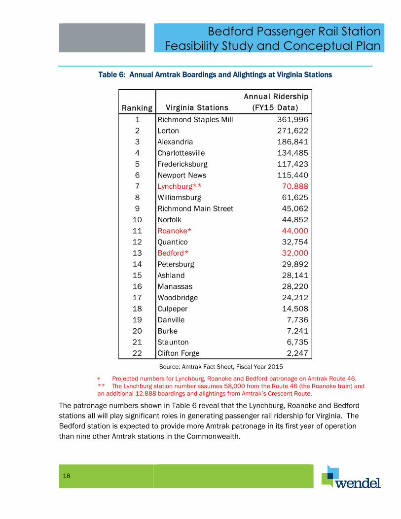
Table 6 shown the number of boardings and alightings that occurred in Fiscal Year 2015 for
Amtrak trains at stations in Virginia. Total Amtrak patronage in Virginia totaled 1,606,007
boardings and alightings for FY 2015. This was about a one percent increase over the total
for FY 2014. It should be noted that the Manassas and Burke Amtrak stations on the NS line
and all of the Amtrak stations from Fredericksburg north to Washington Union Station are
served by VRE trains. The VRE patronage numbers are not included in Table 6 and therefore
total passenger rail patronage at these stations is considerably greater than the numbers
shown. The numbers shown in red for Roanoke, Bedford and Lynchburg are projected
patronage numbers developed for this study. The actual total number of boardings and
alightings for the Lynchburg station in FY15 was 84,975.
Bedford Passenger Rail Station
Feasibility Study and Conceptual Plan
18
Table 6: Annual Amtrak Boardings and Alightings at Virginia Stations
Ranking Virginia Stations
Annual Ridership
(FY15 Data)
1 Richmond Staples Mill 361,996
2 Lorton 271,622
3 Alexandria 186,841
4 Charlottesville 134,485
5 Fredericksburg 117,423
6 Newport News 115,440
7 Lynchburg** 70,888
8 Williamsburg 61,625
9 Richmond Main Street 45,062
10 Norfolk 44,852
11 Roanoke* 44,000
12 Quantico 32,754
13 Bedford* 32,000
14 Petersburg 29,892
15 Ashland 28,141
16 Manassas 28,220
17 Woodbridge 24,212
18 Culpeper 14,508
19 Danville 7,736
20 Burke 7,241
21 Staunton 6,735
22 Clifton Forge 2,247
Source: Amtrak Fact Sheet, Fiscal Year 2015
Projected numbers for Lynchburg, Roanoke and Bedford patronage on Amtrak Route 46.
** The Lynchburg station number assumes 58,000 from the Route 46 (the Roanoke train) and
an additional 12,888 boardings and alightings from Amtrak’s Crescent Route.
The patronage numbers shown in Table 6 reveal that the Lynchburg, Roanoke and Bedford
stations all will play significant roles in generating passenger rail ridership for Virginia. The
Bedford station is expected to provide more Amtrak patronage in its first year of operation
than nine other Amtrak stations in the Commonwealth.

Bedford Passenger Rail Station
Feasibility Study and Conceptual Plan
19
NEEDS ASSESSMENT FOR THE BEDFORD STATION
Facility Program
The first step in developing a conceptual plan for the Bedford Station is to develop a program
for the station. A program is a document that describes the components that will be included
in the station and identifies the size needed
for the site and structures. The generally
accepted guidance for the development of
Amtrak station plans is a document prepared
and published by Amtrak entitled “Amtrak
Station Program and Planning Guidelines”.
In this document Amtrak states that “These
guidelines are intended to assist local
governments, transportation agencies and
authorities, designers, Amtrak staff and other
stakeholders in the planning, design,
construction, rehabilitation and
redevelopment of Amtrak served passenger
stations and related facilities. The guidelines
presented here establish design standards
and criteria for stations platforms and the
station site, starting with governing
principals, followed by information on the
planning and design process, service and
facility types, program requirements, station features and amenities, station finishes and
architectural design.” The Wendel team used this document to determine the appropriate
size and features for the Bedford Station and then working with the project sponsors
developed a specific program for the Bedford Station.
The Amtrak document relies in part upon the categorization of stations based primarily on
passenger volume. Four levels of stations are defined:
Category 1: Large Stations, annual ridership greater than 400,000, fully staffed with
multiple transit services and amenities;
Category 2: Medium Stations, annual ridership between 100,000 and 400,000, lower
levels of staff with some supporting transit and amenities;
Category 3: Caretaker Stations, annual ridership between 20,000 and 100,000,
enclosed waiting areas but no ticket agents and only limited amenities; and

Bedford Passenger Rail Station
Feasibility Study and Conceptual Plan
20
Category 4: Shelter Stations, annual ridership less than 20,000, platforms with only
shelters and/or canopies and no amenities.
With annual ridership projected to be at 32,000, the Bedford Station will fall into Category 3 –
Caretaker Stations and should be programmed and designed accordingly. Figure 4 is taken
from the Amtrak document and shows the features and amenities that should be included in
Bedford Station listed in the column for Caretaker Stations.
This document and a programming questionnaire developed by Wendel were reviewed with
the Town of Bedford and Bedford County, the project sponsors, to develop a program for
Bedford Station. The station programming questionnaire that was completed is found in
Appendix II. Following the Amtrak Station Classification and Features Matrix shown in Figure
4, the Bedford Station Program contains the following elements:
Facility Structure Elements
Platform – An elevated platform is envisioned for the Bedford Station for easy access
by the disabled. The platform will be designed in accordance with Amtrak guidelines.
Platform Canopy – A platform canopy will be included covering two thirds the length of
the platform – as recommended by Amtrak
Sheltered Waiting Area – It is envisioned the platform canopy will serve as a sheltered
waiting area initially and that a waiting area will be included in a future station building.
Station Building – A station building is included in the plans for the Bedford Station as
a future or second phase to the project.
Access and Wayfinding
Auto/Taxi Pick-Up/Drop-Off Lanes – Pick-up and drop-off lanes will be included in the
design for Bedford Station.
Parking – Parking will be included in the design for Bedford Station – including an
expanded parking area as a future or second phase to the project.
Rental Cars on Call – Rental cars will be available in the Town off site.
Rental Cars on Property – No on property rental cars are envisioned for this project.
Transit and Bus Access – Transit and bus access will be provided to the station.
Initially one forty-foot bus bay and access for smaller shuttle vehicles will be provided.
Future expansion may include a second forty-foot bus bay if it is needed.
Taxi Access – Taxi and private transportation access will be provided at the station.
Staff Parking – There will be no staff parking at the station.
Bicycle Racks – Bicycle racks will be provided at the station.

Bedford Passenger Rail Station
Feasibility Study and Conceptual Plan
21
Station Signage (Amtrak Standards) – Station signage will be provided in accordance
with Amtrak standards.
Regulatory Signage (MUTCD) – All appropriate regulatory signage will be included at
the station.
Station Features and Functions
Restrooms – Restrooms will be included in the future station building to be
constructed as a second phase of the project.
Drinking Fountains – Drinking fountains will be included in the future station building
to be constructed as a second phase of the project.
Site Lighting – Site lighting will be included in the design for Bedford Station.
Trash Receptacles – Trash receptacles will be included in the design.
Trash Pick-Up and Snow Removal – The Town of Bedford will perform trash pick-up and
snow removal for Bedford station.
Customer Service
Ticketing and Baggage – An Amtrak Quick-Trak machine is envisioned at Bedford
Station.
Passenger Information – Passenger Information at the Bedford Station will be provided
by the Amtrak Quick-Trak machine.
Security – Surveillance by local police will be provided. Proposed site is located next to
a police station.
Staff and Support Functions – Not appropriate for a Class 3 Caretaker Station as per Amtrak
guidelines.
Amenities
Vending Machines – Vending machines are not anticipated at Bedford Station.
Accommodations may be provided for one or two vendor food trucks in the parking
area or adjacent areas.

Bedford Passenger Rail Station
Feasibility Study and Conceptual Plan
22
Figure 4: Amtrak Station Classification and Features Matrix
Facility Sizing
Platform – Bedford Station will be served by a Virginia sponsored Amtrak train operating on
Route 46. This route is named a Northeast Regional type service. The Amtrak Station

Bedford Passenger Rail Station
Feasibility Study and Conceptual Plan
23
Program and Planning Guidelines instruct that the preferred length for a platform at a station
not located on the Northeast Corridor and served by a Northeast Regional route is 1,000 feet.
The Guidelines further instruct that the minimum length for a platform at such a station shall
be 425 feet. The assumed length for the Bedford Station platform will be 450 feet - slightly
greater than the minimum. This will help to hold down the cost of constructing Bedford
station and still provide adequate length to serve the trains operating on Route 46.
The width of the platform at Bedford Station will be 14 feet. This is within the guidelines set
by Amtrak and sufficiently great to maintain a 6 foot clearance between the edge of the
platform and any obstruction such as a bench for seating. This also is a requirement by
Amtrak.
Waiting Area – The Amtrak Guidelines provide a six step formula for calculating the size of the
passenger waiting area in the station building. The key factor to calculate the size of the
waiting area is the annual ridership at the station. The annual ridership for the Bedford
Station is estimated at 32,000 with two trains serving the station per day. The calculation for
the station’s waiting area is as follows.
1. Daily ridership = Annual ridership/270 or 32,000/270 = 119
Amtrak assumes that ridership will not occur uniformly over the year but that certain days will
have more ridership than others and uses a divisor or 270 days rather than 365 days. The
daily ridership at the Bedford Station is estimated at 119 boardings and alightings.
2. Peak hour 2 way traffic = daily ridership/number of daily trains or 119/2 = 59
Since most travel on Amtrak is round trip travel, Amtrak assumes that each train will proved a
similar number of trips (northbound travel will equal southbound travel). The typical number
of boardings and alightings from each train serving Bedford Station will be 59.
3. Peak hour 1 way traffic = peak hour 2 way traffic * 0.65 or 59 * 0.65 = 39
Amtrak assumes that travel patterns will be uneven and the formula assumes that more than
half the passengers will be boarding. The peak number of people waiting to board a train at
Bedford Station (with the exception of extreme peaks such as Thanksgiving) is calculate at 39
people.
4. Number of people to be seated = Peak hour 1 way traffic * 0.75 or 39 * 0.75 = 30

Bedford Passenger Rail Station
Feasibility Study and Conceptual Plan
24
For long train rides Amtrak suggests that seating should be provided for 75% of the people
waiting to board a train. In the Bedford Station waiting area seating will be provided for 30
people.
5. Seating area required = 20 ft2 * number to be seated or 20 ft2 * 30 = 600 ft2
Amtrak suggests that twenty square feet will be required for each seated passenger. In the
Bedford Station six hundred square feet will be required for seating.
6. Standing area required = 10 ft2 * number of people standing or 10 ft2 * 9 = 90 ft2
Amtrak suggests that ten square feet will be required for each standing passenger. In the
Bedford Station ninety square feet will be required for standing passengers.
7. Total area required = seating area + standing area or 600 ft2 + 90 ft2 = 690 ft2
Based upon Amtrak’s formula, the passenger waiting area inside the station building should
be a least six hundred and ninety square feet.
Parking – According to the Amtrak formula, the peak number of people that will arrive to catch
a train in the morning at the Bedford Station will be thirty-nine people. Some people – such
as families – will be traveling together and arrive in a single automobile. Others will be
dropped off to catch a train and still others will arrive by taxi, bus or shuttles. Assuming that
parking will be required for 75% of the people arriving at the station, a total of twenty-nine
parking spaces will be needed for a peak arrival load. To accommodate trips that last multiple
days and therefore producing uneven demand for parking, a total of fifty parking spaces will
be planned initially at Bedford Station with a future capacity of seventy-five to one hundred
spaces.
SITE SELECTION FOR THE BEDFORD STATION
In the fall of 2015, members of the Bedford-Franklin Regional Rail Initiative (BFRRI) prepared
a white paper that set out the benefits of establishing an Amtrak station in the Town of
Bedford. Included in the white paper was an analysis of prospective sites for the station. The
analysis identified five rail frontage sites in the vicinity of downtown Bedford with reasonable
roadway access and that could accommodate a platform of at least seven hundred feet in
length. The five sites are shown below in Figure 5.
A key factor in selecting a site for Bedford Station will be the suitability of the sites from the
perspective of the owner of the railroad that runs through Bedford, Norfolk Southern Railroad

Bedford Passenger Rail Station
Feasibility Study and Conceptual Plan
25
(NS). The railroad tracks through Bedford are heavily utilized for freight traffic and NS will not
permit the construction of a station if it interferes with rail freight traffic to any significant
extent. Conversations with NS on this topic will be extremely important to this project and
should be initiated as soon as DRPT determines that they will endorse a station at Bedford.
Until DRPT endorses Bedford Station, NS is not likely to engage in conversation about the
acceptability of any station location. In the meantime, evaluation criteria that are significant to
Bedford are most appropriate for initial site screening.
Figure 5: Sites Evaluated for the Location of Bedford Station
In the BFRRI analysis, each of the five sites was evaluated under seven criteria including:
Automobile access
Parking
Bus access
Proximity to the central business district
Real estate cost
Construction cost
Depot St. Site
Bedford Ave. Site
Courthouse Site
Preferred Site Woolen Mills Site
Elks Home Site

Bedford Passenger Rail Station
Feasibility Study and Conceptual Plan
26
Multi-use potential
For each of the evaluation criteria a ranking of one to five was assigned at each prospective
site – with five being the most favorable score. The Courthouse site was identified as the
preferred location in the rankings shown below in Table 7. It should be noted that all of the
sites appear to be viable and each has its own distinct characteristics. It the preferred site
proves to be unacceptable for any reason, other sites noted below should be given careful
consideration.
Table 7: Bedford Station Site Rankings
Criteria Woolen Mills Courthouse Depot St. Bedford Ave. Elks Home
Car Access 2 4 3 3 3
Parking 1 5 3 4 3
Bus Access 3 4 4 3 3
Access to CBD 3 5 4 2 2
Real estate cost 4 5 2 5 1
Construction cost 4 4 3 4 2
Multi-use potential 5 4 2 1 2
Total Score 22 31 21 22 16
SITE EVALUATION FOR THE BEDFORD STATION
A Site Evaluation Report on the suitability of the proposed site for Bedford Station (Appendix
III) was undertaken by Draper Aden Associates – a member of the Wendel Team.
Civil Narrative
The civil narrative was prepared based on the known scope of the proposed project, site
reconnaissance, and readily available information, including aerial photography and
topography, Federal Emergency management Agency (FEMA) Flood Insurance Rate Maps
(FIRM), and the Bedford County GIS.
Standards and codes which govern site development for this project include the Town of
Bedford and Bedford County Erosion and Sediment Control, Stormwater Management, and
Zoning Ordinances, and other commonwealth and federal regulations.
Existing Site Conditions
The subject properties are located within downtown Bedford south of the Norfolk Southern
Railroad, north of E. Depot Street, and adjacent to Plunkett and Court Streets. The proposed

Bedford Passenger Rail Station
Feasibility Study and Conceptual Plan
27
development parcels are owned by the Town of Bedford. Current land uses within the project
areas include the following:
1. An asphalt surface parking lot north of E. Depot Street, south of Plunkett Street and west
of Court Street;
2. Open space south of the Norfolk Southern Railroad and north of Plunkett Street; and
3. A gravel parking / staging area south Plunkett Street and east of Court Street.
The existing topography within the project area has elevations ranging from approximately 978
to 950 (south to north and west to east). The existing parking lot south of Plunkett Street has
retaining walls adjacent to E. Depot Street ranging in height from approximately 6 to 12 feet,
along the west property line ranging in height from approximately 0 to 12 feet, along Court
Street from the south to the entrance ranging in height from 0 to 6 feet.
FEMA Floodplain Considerations
The proposed project lies outside the one (1) percent annual chance (100-year) Zone A
floodplain of John’s Creek.
Zoning
The subject properties are zoned B1 Limited Business. Bus terminal facilities, excluding repairs
and maintenance, with such attendant restaurant and retail facilities as are customarily
incident to the operation thereof and which are primarily oriented to the needs of bus
passengers are permitted uses. Rail facilities are not mentioned as allowable permitted or
conditional uses.
The following is a summary of the zoning requirements / restrictions.
1. Maximum building height: Equal to or less than 40 feet measured from the average
level of the ground adjacent to the front exterior wall
2. Building setbacks: None.
Demolition
During Phase 1, minimal demolition of existing features is anticipated.
For Phase 2, the existing parking lot west of Court Street will be modified to accommodate the
construction of an elevated parking area above the existing lot. Existing sidewalks within the
adjacent rights-of-way of the subject properties along E. Depot Street and Court Street will also
be demolished and replaced, which may also require relocation of existing street lights. Other

Bedford Passenger Rail Station
Feasibility Study and Conceptual Plan
28
existing sidewalks within rights-of-way adjacent to site improvements activities will be removed
and replaced to provide an improved pedestrian experience and access between parking areas
and the future station building.
Roadway / Parking / Pedestrian Access Improvements
Existing roadways will be utilized to access the train station and new parking facilities.
Phase 1: Plunkett Street will likely be resurfaced and curb and gutter added, where needed to
provide positive drainage toward existing and new stormwater inlets. A new sidewalk will be
added along the south side of Plunkett Street and west of Court Street to provide access to the
train station. Pedestrian crosswalk signage and stripping will be added.
Phase 2: An elevated parking area is planned to be constructed above the existing parking lot
north of E. Depot Street and west of Court Street providing a total of 100 parking spaces; there
will be no direct connection between the levels of parking. Sidewalks adjacent to the new
elevated parking area may be replaced.
The access drive to Town Hall (west of Court Street) will likely improved and widened as needed
to provide access to the proposed parking area. A parking area providing approximately 30
spaces is planned to be constructed within the existing gravel lot east of Court Street. This lot
will require approximately 20 feet of 0 to 8 feet high retaining wall. Pedestrian crosswalk
signage and stripping will be added.
Utility Systems
Gas Service
Natural Gas is not available in the area. Several propane providers currently serve the area.
Electric Service
The Town of Bedford Electric Department provides electric service to the Town of Bedford and
part of Bedford County. There is a substation located at the west terminus of Plunkett Street,
south of the Norfolk Southern Railroad, and east of N. Bridge Street. An above-ground
transmission line is located north of and adjacent to Plunkett Street along the length of the
project area.
Communications Service
Shentel provides telecommunication and data service in the area.

Bedford Passenger Rail Station
Feasibility Study and Conceptual Plan
29
Water
Existing
The Bedford Regional Water Authority (BRWA) provides potable water to the Town of Bedford.
In addition to treating potable water, BRWA maintains existing and new lines. The current
capacity of the BRWA water treatment plant is 3 million gallons per day (MGD), with an available
capacity of up to 1 MGD for new development. Existing 8-inch and 10-inch water mains
perimeter the subject properties. Adequate capacity exists and additional demands resulting
from the proposed construction of the Passenger Rail Facility will have no appreciable effect on
the quality of service provided BRWA to the surrounding community.
There is an existing fire hydrant located approximately 60 feet southeast of the proposed
Bedford Fire Station building. One (1) additional fire hydrant may be needed for this project
near the intersection of Court and Plunkett Streets.
Proposed
For the proposed station building domestic water service may be needed. The service is
proposed via a lateral from the existing 10-inch diameter main running perpendicular to the
Norfolk Southern Railroad and Plunkett Street approximately 25 feet east of the future station
building. Existing flow and pressure in the water lines surrounding the project will be verified by
flow testing during the design process to determine the optimum connection point for service.
All exterior fire protection services, as needed, shall be in accordance with the International
Plumbing Code and NFPA 24.
Sanitary Sewer
Existing
BRWA manages and maintains the City of Bedford wastewater infrastructure. An existing 8-inch
sanitary sewer main is located within the Plunkett Street right-of-way and is expected to have
sufficient capacity to serve the future station building. The wastewater treatment plant has a
capacity of 2.0 MGD and currently treats an average of 1.125 MGD.
Proposed
A 50 linear foot 6-inch sanitary sewer lateral is proposed to connect to the 8-inch main to serve
the future station building in Phase 2.

Bedford Passenger Rail Station
Feasibility Study and Conceptual Plan
30
Storm Sewer
Existing
Stormwater runoff from the project area flows into existing inlets and piped system along the
south side of Plunkett Street within the entire project limits; pipe sizes are unknown. This storm
sewer system ultimately discharges to John’s Creek.
Proposed
Phase 1: Additional inlets and manholes are proposed to capture surface runoff from the new
train station and tie into the existing storm sewer on Plunkett Street.
Phase 2: Additional inlets and manholes are proposed to capture surface runoff from the
proposed station building and new parking facilities.
Stormwater Management
Water quantity and quality control will be designed in accordance with the Part IIB criteria of the
Virginia Stormwater Management Program (VSMP) Regulations (9VAC25-870). This project will
be considered to be a redevelopment scenario.
Based on the Phase 1 and 2 plans, the following is a summary of approximate land cover per
phase.
Phase 1: Existing Impervious Area = 0.72 acres
Proposed Impervious Area = 1.01 acres
Proposed Managed Turf Area = 0.56 acres
Phase 2: Existing Impervious Area = 0.43 acres
Proposed Impervious Area = 0.53 acres
Proposed Managed Turf Area = 0.28 acres
Quality Control – Preliminary Analysis
Although the proposed project does not result in an increase of impervious area, the total
phosphorus load must be reduced by at least 20% per 9VAC25-870-63[2.a.] for both phases.
Approximately 0.9 and 0.3 pounds per year of phosphorus load reduction is required for phases
1 and 2 respectively. Compliance may be achieved with a combination of Best Management
Practices (BMPs) such as dry swales, bioretention, and/or manufactured BMPs (e.g. Filterra).
Any BMP’s selected shall meet the Standards and Specifications of the Virginia Stormwater
BMP Clearinghouse. For example for the Phase 1 development, a Level 1 dry swale or
bioretention treating 0.8 acres of impervious area will meet the required pollutant removal.

Bedford Passenger Rail Station
Feasibility Study and Conceptual Plan
31
Quantity Control – Preliminary Analysis
The proposed project does increase impervious surface area, therefore stormwater quantity
control facilities will be required per 9VAC25-870-66[B.1.a]. Stormwater quantity control could
be provided via a bio retention facility or underground detention for this project.
ENVIRONMENTAL IMPACT OF THE PROPOSED BEDFORD STATION
An Environmental Impact Review for the Bedford Station project was undertaken by Draper
Aden Associates – a member of the Wendel Team – and can be found in Appendix IV.
Approach to Environmental Review
The project approach for the Environmental Analysis and Documentation assumes that design
and construction of the train station will not be supported by Federal funds. Therefore, the
provisions of the National Environmental Protection Act (NEPA) will not apply to the project.
However, since the construction may be undertaken under VDRPT funding and the cost may
exceed $500,000, environmental review under Virginia Code §10.1-1188 may become
applicable. Therefore, environmental analysis for this project was proposed and completed in
general accordance with the state Environmental Impact Review (EIR) process.
This report presents the Environmental Analysis of the project was prepared and formatted in
general accordance with the guidance provided in VDEQ’s Procedure Manual for
Environmental Impact Reviews of Major State Facilities dated July 2013. At the start of this
project in January 2016, a larger, general project area was identified, on which this
environmental analysis was completed (Figures 6 & 7). A preliminary concept plan was
prepared for a subset area within the larger general project area previously identified for the
project, and this concept plan was included, where appropriate, in the environmental
evaluation.
To complete the Environmental Analysis, standard environmental records, tribal records,
physical setting sources including topographic maps, geologic maps, soils maps, wetland and
floodplain maps, and prior site reports were identified and reviewed. A site reconnaissance
was conducted for a visual inspection of the site. The interior of buildings was not observed.
Information was retrieved from a number of sources identified in Section 8.0. Regulatory
agencies were contacted, as needed, to conduct a project review relative to environmental
sources for inclusion in this EIR. Additional regulatory agency input may be received by the
Virginia Department of Environmental Quality’s (VDEQ) or elsewhere during subsequent
submittals and reviews as part of the funding requirements. Where information was readily
available within limited sources, consideration of existing environmental impacts, if any, from

Bedford Passenger Rail Station
Feasibility Study and Conceptual Plan
32
on and off-site sources, such as petroleum releases, was also included in this review.
However, the completed review of existing environmental impacts within the project area is
limited and should not be construed a comprehensive effort which is typically achieved under
a Phase I Environmental Site Assessment (ESA) process. A full account of the methodology,
findings and documentation of the environmental analysis preformed for this project is
provided as Appendix IV to this report. Selected excerpts to the full report are provided below.
Figure 6: Environmental Review Site Location Map

Bedford Passenger Rail Station
Feasibility Study and Conceptual Plan
33
Figure 7: Environmental Review Site Detail Map

Bedford Passenger Rail Station
Feasibility Study and Conceptual Plan
34
Site Description
The project site is located within the Town of Bedford in Bedford County, Virginia. The existing
rail line runs approximately through the center of the larger project area. Figure 6, Site
Location Map, identifies the site and vicinity. Figure 7 highlights the larger project area as well
as the specific site within the larger project area identified at this time as the preferred,
proposed location for the passenger rail station, on an aerial photograph from 2012.
The larger project site includes relatively steep gradients that slope downward towards the
existing rail line primarily near Bridge Street. The gradient shallows to the east toward Grove
Street, where the rail line crosses the road at grade. Along Plunkett Street, the rail line is only
slightly topographically lower; however, topography slopes upward again from Plunkett Street
to the south toward Main Street. The current preferred, proposed passenger rail station
development area is south of the rail line along Plunkett Street near the County Courthouse as
illustrated on the site conceptual drawings shown in a subsequent section of this report.
However, all areas shown as potential sites in Figure 5 remain under consideration.
Currently, the area south of the N&S railroad, south of E. Depot Street and adjacent to
Plunkett and Court Streets is the preferred and proposed development area under
consideration. Current land uses within this area includes asphalt parking and open space
areas. Topography in this area ranges from 978 to 952 feet above mean sea level.
Current Land Uses
The project site is located in a mixed use area of the Town of Bedford that includes a variety of
residential, community, commercial, light industrial, transportation and recreational uses. The
rail line passes through the approximate center of the larger general project area. West of
Bridge Street is a small pocket park on the northern side and undeveloped property covered
with vegetative overgrowth and a parking lot on the southern side. To the north of the rail line
are open spaces including parking and a community garden along Jackson Street. Further
east along Jackson Street and bounded by Grove Street is a former industrial complex that is
currently vacant with the exception of some residential revitalization in one of the buildings. A
cemetery is also located adjacent to the industrial complex along Jackson Street. To the south
of the rail line are a mix of private commercial/light industrial developments until passing
Stone Street at which point the project area is primarily undeveloped open space or parking.
An electrical substation is located on the southern side of the rail line adjacent to Bridge
Street to the west and is excluded from the potential development area. Light industrial and
commercial buildings are located within the project area on the eastern side of the site, north
and south of the rail line. A portion of the industrial buildings on the northeastern side has

Bedford Passenger Rail Station
Feasibility Study and Conceptual Plan
35
been converted into residential loft space. These buildings are privately owned and no
demolition or renovation to these buildings is planned or anticipated. Demolition of existing
parking areas and sidewalks are planned, which may require relocation of existing fire
hydrants, street lights, stormwater drainage and other subsurface and aboveground utilities
and structures.
Utilities currently available to the site include electric, water, sewer, and communications.
Natural gas is not available. Stormwater runoff currently flows into existing inlets and piped
system along the south side of Plunkett Street and ultimately discharges to Johns Creek. A
map of existing utility lines at and near the site is included in Appendix B of the full
environmental report.
The Town of Bedford recently passed a resolution that would allow the rail station to fit within
the Comprehensive Plan. Current zoning within the Town-owned properties and the area of the
current concept plan is B1 Limited Business. Portions of the privately owned properties in the
eastern portion of the site are zoned CNW Central Neighborhood Work or CLI
Commercial/Light Industrial and include current and former commercial and light industrial
properties. Rail facilities are not currently mentioned as allowable permitted or conditional use
and may require special permitting. However, the project site is located in an urban area of
the Town of Bedford and the planned future use appears consistent with current surrounding
property uses. Representative photographs of the site and vicinity are included in Appendix A
of the full environmental report.
Summary of Potential Impacts
As noted previously, a full account of the methodology, findings and documentation of the
environmental analysis preformed for this project is provided as an Appendix to this report. In
the full report, the various sections describe and analyze direct, indirect, and cumulative
effects on environmental resources (identified in the EIR Procedure Manual Section B.3) as a
result of the preferred alternative. Additional resources were identified beyond those listed in
the EIR Procedure Manual and are included in the report. Specific resource information was
obtained through published documents, database research, visual observations made during
a site reconnaissance conducted on February 8, 2016, and correspondence with regulatory
agencies relative to the site and surrounding areas. Environmental resource and agency
correspondence documentation is included in Appendix C to the full report, where available, or
is referenced within the EIR (Appendix IV, Section 7.0).
Each of the sections of the full report identifies resources, if present and evaluates the
potential effect on those resources as a result of the proposed action. For this evaluation, all

Bedford Passenger Rail Station
Feasibility Study and Conceptual Plan
36
areas of the larger project area were considered for future development. Where the effect of
the proposed action is different depending on the area of planned development within the
overall project area, it is noted. Otherwise, a statement of effect or no effect anticipated
applies to the entire project area.
Table 8 outlines the anticipated effects of the proposed action on resources identified and
reviewed as part of this project.
Table 8: Summary of Potential Impacts

Bedford Passenger Rail Station
Feasibility Study and Conceptual Plan
37
Table 8: Summary of Potential Impacts (Continued)
Overall, the long term results of the project are considered beneficial to the community. No
significant adverse effects to environmental resources were identified, pending information
from VDHR. The proposed project will have negligible effect to the cumulative effect of
continued urban development in the area.
Short-term impacts related to construction will be low to moderate in nature. Long-term
effects from operation include increased noise and a potential increase in local vehicular
traffic. The effect on local traffic is countered by a regional benefit to transportation
thoroughfares from the inclusion of this rail station connecting the Town of Bedford with the
Cities of Lynchburg and Roanoke.
Potential sources of impact to the site from existing/historical commercial/industrial
operations may exist in the vicinity of the proposed action. Additionally, potential on-site
sources of impact exist, primarily related to former and current rail operations and long term
urban development in the area. Special handling of material may be required at the time of
design and construction, if impact is identified.
VDHR’s project review of the proposed action is pending. Based on verbal communication with
VDHR from February 11 and 12 and subsequent to the project review request submittal, it is
possible that an effect determination from VDHR may require additional site evaluation
including potential archaeological survey of portions of the project area and/or special
consideration of architectural resources in and near the project area. However, mitigation
options currently exist related to the proposed action and it is unlikely that the effect to
historic resources will significantly affect the proposed action. Mitigation may require

Bedford Passenger Rail Station
Feasibility Study and Conceptual Plan
38
specific design considerations or restrict ground disturbance in certain areas. Additional
coordination with VDHR will likely be required during the design process.
Once the project progresses, if any material is unearthed during site grading or excavating
that could potentially be of archaeological significance, construction activities should cease
and VDHR should be contacted for guidance. Information from VDHR, once received, will be
provided as an addendum.
ECONOMIC IMPACT OF THE PROPOSED BEDFORD STATION
An analysis of the Economic Impact of Bedford Station was prepared by Chmura Economics
and Analytics – a member of the Wendel Team. Their report is found in Appendix V of this
report.
An important consideration in evaluating the feasibility of establishing a Bedford Amtrak
Station is whether there is a business case for the project. Making the business case includes
an assessment of the improvements that the project will make to the mobility of people in the
region. This has been identified in the patronage analysis discussed in a previous section of
the report. The business case also includes and assessment of the economic impacts of the
project. As part of the Wendel team, Chmura Economics & Analytics (Chmura) was contracted
to perform an economic impact analysis of Bedford station for the Bedford region. The study
region is defined as the counties of Bedford and Franklin.
The economic impact of Bedford station can be realized in two phases: (1) initial capital
investment, which provides a one-time impact during the construction period, and (2) Bedford
station operations, which includes the operations of Amtrak, potential intercity bus and
regional bus service, and taxi service after the project is completed. For both phases, the
direct, indirect, and induced impacts in spending and job creation are estimated.
The direct impact is defined as the primary economic activity generated by the project under
consideration. The indirect impact is the secondary economic activity generated by the project
via demand for products from suppliers. An example of indirect impact is a construction
company purchasing construction materials. The induced impact is economic activity
generated when construction workers spend their income as consumers (such as at retail,
restaurants, and doctor’s offices) in the region. Chmura used the IMPLAN Pro® model1 to
simulate the economic impact of this project. Outside the economic impact of the initial
1 IMPLAN Professional was created in the 1970s by the Forestry Service and is widely used by economists to estimate the
impact of specific events on regional economies. It is now owned by Minnesota IMPLAN Group.
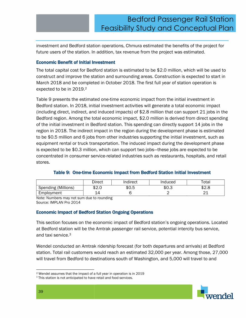
Bedford Passenger Rail Station
Feasibility Study and Conceptual Plan
39
investment and Bedford station operations, Chmura estimated the benefits of the project for
future users of the station. In addition, tax revenue from the project was estimated.
Economic Benefit of Initial Investment
The total capital cost for Bedford station is estimated to be $2.0 million, which will be used to
construct and improve the station and surrounding areas. Construction is expected to start in
March 2018 and be completed in October 2018. The first full year of station operation is
expected to be in 2019.2
Table 9 presents the estimated one-time economic impact from the initial investment in
Bedford station. In 2018, initial investment activities will generate a total economic impact
(including direct, indirect, and induced impacts) of $2.8 million that can support 21 jobs in the
Bedford region. Among the total economic impact, $2.0 million is derived from direct spending
of the initial investment in Bedford station. This spending can directly support 14 jobs in the
region in 2018. The indirect impact in the region during the development phase is estimated
to be $0.5 million and 6 jobs from other industries supporting the initial investment, such as
equipment rental or truck transportation. The induced impact during the development phase
is expected to be $0.3 million, which can support two jobs—these jobs are expected to be
concentrated in consumer service-related industries such as restaurants, hospitals, and retail
stores.
Table 9: One-time Economic Impact from Bedford Station Initial Investment
Direct Indirect Induced Total
Spending (Millions) $2.0 $0.5 $0.3 $2.8
Employment 14 6 2 21
Note: Numbers may not sum due to rounding
Source: IMPLAN Pro 2014
Economic Impact of Bedford Station Ongoing Operations
This section focuses on the economic impact of Bedford station’s ongoing operations. Located
at Bedford station will be the Amtrak passenger rail service, potential intercity bus service,
and taxi service.3
Wendel conducted an Amtrak ridership forecast (for both departures and arrivals) at Bedford
station. Total rail customers would reach an estimated 32,000 per year. Among those, 27,000
will travel from Bedford to destinations south of Washington, and 5,000 will travel to and
2 Wendel assumes that the impact of a full year in operation is in 2019 3 This station is not anticipated to have retail and food services.

Bedford Passenger Rail Station
Feasibility Study and Conceptual Plan
40
through Washington to further destinations. Based on current sample prices from Lynchburg’s
Amtrak station, the average one-way ticket is assumed to cost $61.6 in 2016.4
It is anticipated that Bedford station will also host a regional bus stop and may host an
intercity bus stop, which provides daily intercity bus service from Bedford to cities around the
region and state. Currently, the closest intercity bus services to Bedford are the Greyhound
stations in Roanoke and Lynchburg.5 Assuming an intercity bus service similar to Greyhound is
established at Bedford station, Chmura estimates that total passengers (departures and
arrivals) for the intercity bus service will be 9,472 per year. The average ticket price per bus
trip would be $27.30 in 2016.6 For taxi service at Bedford station, it is assumed that 15% of
rail and bus passengers will need a taxi, with an average fare of $5 in 2016.7
The total annual operational impact (direct, indirect, and induced impacts) of Bedford station
is estimated to be $3.4 million in 2019, which can support 9 jobs in the Bedford region.8
Among those impacts, direct revenue from the Amtrak operation, intercity bus service, and
taxi service at the station are estimated to be $2.4 million, which can support 6 jobs. The
indirect impact is estimated to be $0.7 million and 2 jobs, benefiting other businesses within
the region that support rail, bus, and taxi service. The induced impact is estimated to be $0.3
million and 1 job in the region, mostly benefiting consumer-related businesses such as retail
shops, healthcare facilities, and restaurants. The total annual economic impact of ongoing
operations of Bedford station is summarized in Table 10.
Table 10: Annual Economic Impact of Bedford Station Operation (2019)
Direct Indirect Induced Total Impact
Amtrak Operation Spending ($Million) $2.1 $0.5 $0.3 $2.9
Employment 3 2 1 6
Bus Operation Spending ($Million) $0.3 $0.2 $0.0 $0.4
Employment 2 0 0 2
Taxi Spending ($Million) $0.0 $0.0 $0.0 $0.0
Employment 1 0 0 1
Total Spending ($Million) $2.4 $0.7 $0.3 $3.4
Employment 6 2 1 9 Note: Numbers may not sum due to rounding
Source: IMPLAN Pro 2014
4 Chmura researched February 2016 ticket prices from Lynchburg to Washington and New York. 5 The operational details of an intercity bus stop are not available. Currently, there is no intercity bus service in Bedford.
Chmura uses assumptions from similar stations in other cities such as Roanoke to estimate the passenger volume. 6 This is estimated based on a similar station in Roanoke. Chmura also researched February 2016 Greyhound bus ticket
prices from Lynchburg to cities including Richmond and Washington, D.C. Greyhound is the only intercity bus service in the
Roanoke/Lynchburg area. 7 Source: This is estimated based on data for similar stations in other cities such as Roanoke. 8 In this report, estimated jobs include both full-time and part-time. It does not include full-time-equivalent (FTE) jobs.
Bedford Passenger Rail Station
Feasibility Study and Conceptual Plan
41
Bedford Station User Benefits
Outside the economic impact of operations, Bedford station can also provide other ongoing
benefits for users of the station. Individuals impacted by Bedford station will be passengers of
both Amtrak and the intercity bus service.
There are three broad user benefits estimated in this study. The first benefit is travel time
savings from congestion mitigation. Though using a bus or rail service may increase travel
time for passengers, it reduces the number of vehicles on area roads, providing traffic
congestion relief for many drivers. The second benefit is motor vehicle-related cost savings.
Individuals traveling by rail or bus will reduce their usage of vehicles, thus saving money on
operational costs. The third benefit is safety. Fewer vehicles on the road can reduce both
accidents and accident-related injuries. The safety benefit also reduces inconveniences and
costs involved with both minor and major car accidents. Though not quantified in this study,
the resulting decrease in automobile usage can help reduce greenhouse gas emissions,
resulting in environmental benefits.
The estimated benefit for Bedford station users will depend on reduced vehicle miles travelled
(VMT) as users shift from using automobiles to buses or trains. Travel time savings, vehicle
operation cost reduction, and safety benefits are all based on reduced VMT.9 Based on the
average trip length and number of rail and bus passengers, it is estimated that Bedford
station can reduce VMT by an estimated 9.4 million miles per year in 2019. The majority of
VMT reduction comes from Amtrak operations, and the rest comes from the intercity bus
service.
Bedford station is expected to divert traffic from highways and streets. Less traffic will reduce
congestion of regional roadways, thus providing travel time savings for motorists. The cost of
traffic congestion is assumed to be 6.9 cents per VMT in 2019.10 Applying this to total
diverted vehicle miles, the annual benefit of travel time savings is estimated to be $0.6
million in 2019 (Table 11).
9 Chmura uses the same methodology as in the 2013 study: Benefit/Cost Analysis of Main Street Station Multimodal
Transportation Center, prepared by Chmura Economics & Analytics, December 2013. 10 Inflated from the 2007 value, which can be found in the following documentation: Corporate Average Fuel Economy for
Model Year (MY) 2012-MY 2016 Passenger Cars and Light Trucks. US Department of Transportation, National Highway Traffic
Safety Administration, August 2009.

Bedford Passenger Rail Station
Feasibility Study and Conceptual Plan
42
Table 11: Estimated Annual User Benefits ($Million 2019)
Value of Travel Time Saving $0.6
Vehicle Operation Cost Saving $3.6
Safety Benefit $0.3
Total $4.5
Source: Chmura Economics & Analytics
Vehicle operation cost is reduced as travelers switch from cars to buses and trains. Those
individuals incur additional costs to purchase bus or train tickets. As a result, bus or train
ticket costs need to be excluded from the benefit of the project. The annual cost of vehicle
operation is assumed to be 58 cents per VMT in 2015.11 This figure includes fuel,
maintenance, and repair costs. Total diverted vehicle miles are estimated to be 9.4 million per
year. In 2016, the average bus fare from Bedford to various locations is assumed to be
$27.30 per trip, while the average train ticket from Bedford to locations such as Washington,
D.C. and beyond is assumed to be $61.6 per trip. These numbers are inflated to 2019 values
using the consumer price index before being subtracted from vehicle operation cost savings.
As a result, the net benefit of vehicle cost savings is estimated to be $3.6 million in 2019.
Bedford station is expected to divert traffic from highways and streets. Less traffic will reduce
the probability of crashes as well as property damage and injury costs associated with car
accidents. In 2019, the cost of a car accident is assumed to be 3 cents per vehicle mile
traveled.12 The annual safety benefits are estimated to be $0.3 million in 2019.
In summary, total user benefits are estimated to be $4.5 million per year in 2019 dollars for
users of Bedford station.
Fiscal Impact for State and Local Governments
Both the initial development activities and ongoing operation of Bedford station will generate
tax revenue for local and state governments. In order to be conservative, only tax revenue
from the direct impact was estimated.13
During the initial development phase (2016 to 2017), local governments in Virginia can
typically collect business, professional, and occupational license (BPOL) tax. Since neither
11 The latest estimate from AAA indicated driving cost per mile was 58 cents in 2015. Source: http://exchange.aaa.com/wp-
content/uploads/2015/04/Your-Driving-Costs-2015.pdf 12 This is inflated from the 2007 value, which can be found in the following documentation: Corporate Average Fuel Economy
for Model Year (MY) 2012-MY 2016 Passenger Cars and Light Trucks. US Department of Transportation, National Highway
Traffic Safety Administration, August 2009. 13 This approach is recommended by Burchell and Listokin in The Fiscal Impact Handbook.

Bedford Passenger Rail Station
Feasibility Study and Conceptual Plan
43
Bedford County nor Franklin County requires BPOL tax, the estimated local tax revenue is
zero. The state government is expected to receive $19,859 in individual income tax and
$5,347 in corporate income tax from the initial development activities of the project. To arrive
at those figures, Chmura first used the IMPLAN Pro model to assess the percentages of total
initial investment allocated to both labor cost and profit. Chmura then applied those
percentages to the direct initial investment before applying an individual income tax rate of
5% and a corporate income tax rate of 6%.14
Table 12: Tax Revenue from Bedford Station
Local Governments State Government
Initial Investment (2018) Individual Income Tax $19,859
Corporate Income Tax $5,347
Total $0 $25,206
Ongoing Operations (2019 ) Individual Income Tax $20,924
Corporate Income Tax $17
Total $0 $20,940
Note: Numbers may not sum due to rounding
Source: Chmura Economics & Analytics
For ongoing operation, since the station will not have retail or food services, local
governments will not collect any sales or meals tax from the operation. BPOL tax is irrelevant
as well because Bedford County does not have this tax. The state government can benefit
from individual and corporate income taxes from the ongoing operation of Bedford station.
The state individual and corporate income tax revenues are estimated to be $20,924 and
$17 (from bus and taxi services),15 respectively, in 2019.
CONCEPTUAL PLANS FOR THE BEDFORD STATION
As described previously in this report, the Wendel team used a document prepared and
published by Amtrak entitled “Amtrak Station Program and Planning Guidelines” to determine
the appropriate size and features for the Bedford Station. These guidelines establish design
standards and criteria for stations platforms and the station site, program requirements,
station features and amenities, station finishes and architectural design. The Wendel team
reviewed this document with the project sponsors and then jointly developed a specific
program for the Bedford Station. It is proposed that Bedford Station should be advanced in
14 Source: Virginia Tax Department. 15 Recent financial statements for Amtrak show that its operational expense is greater than its operational revenue. As a
result, Amtrak’s corporate income tax obligation is zero.

Bedford Passenger Rail Station
Feasibility Study and Conceptual Plan
44
two phases. Phase 1 would produce a safe, functional and attractive station and if the station
proves to be successful and warrant additional improvements, Phase 2 would add a station
building, additional bus access and additional parking. The phased approach is proposed to
hold down the cost for establishing Bedford Station and getting it operational. It is expected
that the success of the station once it is opened will generate enthusiasm to advancing the
station to the second phase. All conceptual design components are in accordance with
Amtrak’s guidelines for a Category 3 or Caretaker Station.
Phase 1
In the first phase of the project, it is proposed to construct the rail passenger platform, vehicle
and pedestrian access, and to improve an existing parking area. Figure 8 shows a conceptual
site plan for Phase 1 of Bedford Station. Conceptual renderings of the station and facilities in
Phase 1 are shown in Figures 10, and 11.
The platform will be 450 feet long and 14 feet wide. This is 25 feet longer than the minimum
recommended by Amtrak and 2 feet wider. The additional length allows for easier positioning
of a six car train when it stops at the platform. The additional width is required to maintain a
minimum 6 foot clearance from the edge of the platform to any obstruction. The surface of
the platform will be constructed 48 inches above the top of the rail to allow level boarding.
Canopies will be constructed on the platform to offer shelter to waiting rail passengers. In
addition, wind screens and benches will be provided on the platform. Seating will be available
for 36 passengers on the platform. An Amtrak Quick-Trak ticketing machine will be provided
on the platform. The platform also will have lighting and trash and recycling receptacles.
Pedestrian access will be provided via a paved area between the vehicle drop off area and the
platform. Landscaping will be provided throughout the site. Bicycle racks will be provided in
the paved area as well as Amtrak signage.
An eight space vehicle drop off area will be provided in front of the station just off of Plunkett
Street and separated from the street by a median. A bus bay will be provided at the east end
of the station as a pull off area from Plunkett Street heading westbound.
In phase 1 a parking area will be improved in the area bordered by Plunkett Street, Court
Street and East Depot Street. The parking area will be accessed from Plunkett Street and will
contain 50 parking spaces.
A conceptual level cost estimate was prepared for constructing phase 1 of the project at the
preferred site and as shown in the conceptual drawings. The estimate was developed using
current wage rates and materials costs for the Bedford area. The estimate includes general

Bedford Passenger Rail Station
Feasibility Study and Conceptual Plan
45
conditions costs, a construction manager fee, escalation over an 18 month construction
period and a design contingency of 25%. A summary of the estimate is shown below in Table
13. A full detailed estimate is provided in Appendix VI. The estimate indicates that phase 1 of
Bedford Station could be constructed and equipment provided for the facility for
approximately $1.5 million. If the preferred site proves to be unacceptable to Norfolk
Southern and another site is selected, additional site improvements may be required. We
expect that phase 1 of the Bedford Station project could be constructed at other prospective
sites that have been identified for under $2.0 million.
Table 13: Conceptual Level Construction Estimate for Phase 1
Total Material Total Labor Total Cost Building $/GSF % of Total
01 GENERAL REQUIREMENTS -$ 4,807$ 4,807$ 0.0984$
02 EXISTING CONDITIONS -$ 30,000$ 30,000$ 0.6141$
03 CONCRETE 19,070$ 10,952$ 30,023$ 0.6146$
05 METALS 126,687$ 9,888$ 136,575$ 2.7956$
10 SPECIALTIES 107,880$ 201,870$ 309,750$ 6.3404$
11 EQUIPMENT 2,250$ 1,230$ 3,480$ 0.0712$
12 FURNISHINGS 12,080$ 34$ 12,114$ 0.2480$
26 ELECTRICAL -$ 100,000$ 100,000$ 2.0470$
31 EARTHWORK 48,987$ 57,601$ 106,588$ 2.1818$
32 EXTERIOR IMPROVEMENTS 176,989$ 152,421$ 329,410$ 6.7429$
493,944$ 568,804$ 1,062,747$ 21.75$ 70.8%
GENERAL CONDITIONS (CM) 3% 31,882$ 0.65$ 2.1%
Subtotal: 1,094,630$ 22.41$ 72.9%
CONSTRUCTION MANAGER FEE 5% 54,731.49$ 1.12$ 3.6%
Subtotal: 1,149,361$ 23.53$ 76.5%
ESCALATION 4.54% 52,135$ 1.07$ 3.5%
Subtotal: 1,201,496$ 24.59$ 80.0%
DESIGN CONTINGENCY 25% 300,374$ 6.15$ 20.0%
Project Gross Square Feet (GSF) 48,853
TOTAL: 1,501,870$ 30.74$ 100.0%
Division
ARCHITECTURAL TOTALS:
Phase 2
If Bedford station is successful and ridership warrants additional improvements to the station,
a second phase of construction is envisioned. In the second phase of the project, it is
proposed to construct a rail station building, add a second bus bay and construct additional

Bedford Passenger Rail Station
Feasibility Study and Conceptual Plan
46
parking. Figure 9 shows a conceptual site plan for Phase 2 of Bedford Station. Conceptual
renderings of the station and facilities in Phase 2 are shown in Figures 12, 13, 14 and 15.
The building constructed in phase two would be climate controlled and include a waiting area,
restrooms, drinking fountains, storage areas, and an area to relocate the Amtrak Quick-Trak
ticketing machine. The actual size and floor plan for the building will be developed during the
architectural and engineering design for Phase 2. The building shown in the conceptual
drawings for Phase 2 is drawn to a scale of approximately 2,400 square feet – more than
enough to meet the program requirements as currently envisioned.
Phase 2 includes the construction of a second bus bay which will be located as a pull off from
Plunkett Street heading eastbound. This will allow more transit access to the station when
the trains arrive and depart and will support regional buses.
Phase 2 also includes an expansion of parking at the station. Two options for parking
expansion are shown in the conceptual site plan. A second surface parking lot is shown east
of Court Street at the corner with Plunkett Street. Access to this parking area would be from
Plunkett Street. The parking area would include a passenger drop off area and 28 additional
parking spaces.
If additional parking is needed beyond the second surface lot, the Phase 2 conceptual plans
show that the 50 space surface lot in Phase 1 could be converted to a parking deck with 100
spaces. Access to the lower level of parking would be from Plunkett Street and access to the
upper level of parking would be from East Depot Street.
A conceptual level cost estimate was not prepared for the improvements for Phase 2. All of
the elements shown in the conceptual drawings for Phase 2 are optional. However the
construction of a station building is called for in Amtrak’s Station Program and Planning
Guidelines for a Level 3 station and it is strongly recommended for Bedford. This will provide
an attractive, convenient and comfortable place for Amtrak passengers to wait for trains and
will create a more significant sense of place for Bedford Station.

47
Figure 8: Bedford Station Conceptual Site Plan - Phase 1

48
Figure 9: Bedford Station Conceptual Site Plan - Phase 2

49
Figure 10: Bedford Station Conceptual Image - Phase 1 Aerial View

50
Figure 11: Bedford Station Conceptual Image - Phase 1 Approach to the Platform from the West

51
Figure 12: Bedford Station Conceptual Image - Phase 2 Aerial View

52
Figure 13: Bedford Station Conceptual Image - Phase 2 Approach to the Station from the West

53
Figure 14: Bedford Station Conceptual Image - Phase 2 Approach to the Station from the East

54
Figure 15: Bedford Station Conceptual Image - Phase 2 Platform View


