
WRL Technical Report 2017/09 FINAL OCTOBER 2017 H-1
Appendix H: Broulee Island Connectivity
Broulee Island and tombolo are located at the southern end of Broulee Beach.
A tombolo is a salient (foreshore widening) which extends sufficiently to connect dry sand
(i.e. above mean sea level) to an offshore feature (such as an island). Where a feature is
located sufficiently close to shore, sand will accumulate in the lee to form a tombolo during
periods of low wave energy. During high wave energy, tombolos may be severed from the
feature, resulting in a salient. Once connected, a tombolo will starve downdrift beaches of
normal longshore sediment supply. The effect of periodic tombolos is the temporary storage and
release of a “slug” of sediment to the downdrift region (Chasten et al., 1993).
The periodic or ephemeral tombolo at Broulee Island has been historically breached during large
swells, separating the island from the mainland temporarily, although the most recently recorded
breach occurred sometime between May 1984 and May 1987.
Ballard (1982) provides an extensive history of the salient/tombolo at Broulee Island between
1828 and 1981. A variety of data sources were used including maps, photographs, illustrations,
documented observations and NSW legislative assembly proceedings. Ballard found that the
tombolo was severed rapidly from waves originating on its southern side (Bengello Beach) but
then took a longer period of time to re-connect to the island. Analysis of a series of aerial
photographs between 1961 and 1981 clearly showed the transport of sediment from the tombolo
to the north into Broulee Bay when it was breached.
The status of the Broulee Island tombolo between 1828 and 1901 has been tabulated by WRL in
Table H-1, based on findings by Ballard (1982). In 1873, shortly before it was severed,
vegetation (including root systems) on the tombolo was removed to widen a track which existed
between Broulee Island and the mainland. From 1920 to 1930, shell-grit was mined from within
Broulee Bay which may have resulted in a depleted supply of sediment to maintain the tombolo
(Ballard, 1982). Unfortunately there are large gaps in the record when the tombolo may have
been severed which have gone unrecorded, particularly between 1901 and the first aerial
photograph in 1961.
Table H-1: History of Broulee Island Salient/Tombolo Condition (1828-1901)
Date Salient/Tombolo Condition Reference
1828 Connected Ballard (1982)
1837 Connected Ballard (1982)
1839 Connected Ballard (1982)
1841 Disconnected (Possible) Ballard (1982)
1843 Disconnected Ballard (1982)
1845 Connected Ballard (1982)
1869 Disconnected Ballard (1982)
1873 Disconnected Ballard (1982)
1891 Connected Ballard (1982)
1892 Connected Ballard (1982)
1901 Disconnected (Possible) Ballard (1982)
WRL Technical Report 2017/09 FINAL OCTOBER 2017 H-2
Ballard’s aerial photography analysis has been extended by WRL through examination of
historical aerial images provided by the Office of Environment and Heritage (OEH) between 1961
and 2011 (reproduced at the end of this appendix as Figure H-2 to Figure H-19). Additional
photographs from other sources were also collected and included in the analysis with the status
of the Broulee Island tombolo between 1961 and 2017 tabulated in Table H-2.
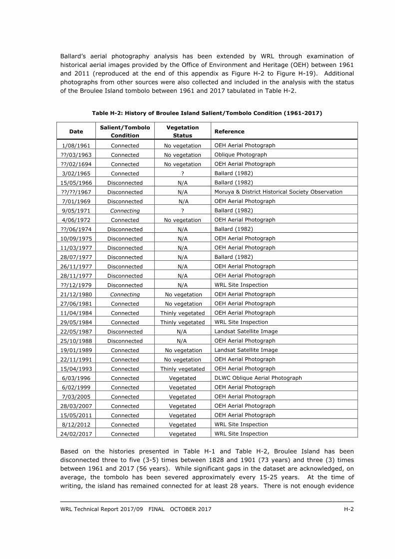
Table H-2: History of Broulee Island Salient/Tombolo Condition (1961-2017)
Date Salient/Tombolo
Condition
Vegetation
Status Reference
1/08/1961 Connected No vegetation OEH Aerial Photograph
??/03/1963 Connected No vegetation Oblique Photograph
??/02/1694 Connected No vegetation OEH Aerial Photograph
3/02/1965 Connected ? Ballard (1982)
15/05/1966 Disconnected N/A Ballard (1982)
??/??/1967 Disconnected N/A Moruya & District Historical Society Observation
7/01/1969 Disconnected N/A OEH Aerial Photograph
9/05/1971 Connecting ? Ballard (1982)
4/06/1972 Connected No vegetation OEH Aerial Photograph
??/06/1974 Disconnected N/A Ballard (1982)
10/09/1975 Disconnected N/A OEH Aerial Photograph
11/03/1977 Disconnected N/A OEH Aerial Photograph
28/07/1977 Disconnected N/A Ballard (1982)
26/11/1977 Disconnected N/A OEH Aerial Photograph
28/11/1977 Disconnected N/A OEH Aerial Photograph
??/12/1979 Disconnected N/A WRL Site Inspection
21/12/1980 Connecting No vegetation OEH Aerial Photograph
27/06/1981 Connected No vegetation OEH Aerial Photograph
11/04/1984 Connected Thinly vegetated OEH Aerial Photograph
29/05/1984 Connected Thinly vegetated WRL Site Inspection
22/05/1987 Disconnected N/A Landsat Satellite Image
25/10/1988 Disconnected N/A OEH Aerial Photograph
19/01/1989 Connected No vegetation Landsat Satellite Image
22/11/1991 Connected No vegetation OEH Aerial Photograph
15/04/1993 Connected Thinly vegetated OEH Aerial Photograph
6/03/1996 Connected Vegetated DLWC Oblique Aerial Photograph
6/02/1999 Connected Vegetated OEH Aerial Photograph
7/03/2005 Connected Vegetated OEH Aerial Photograph
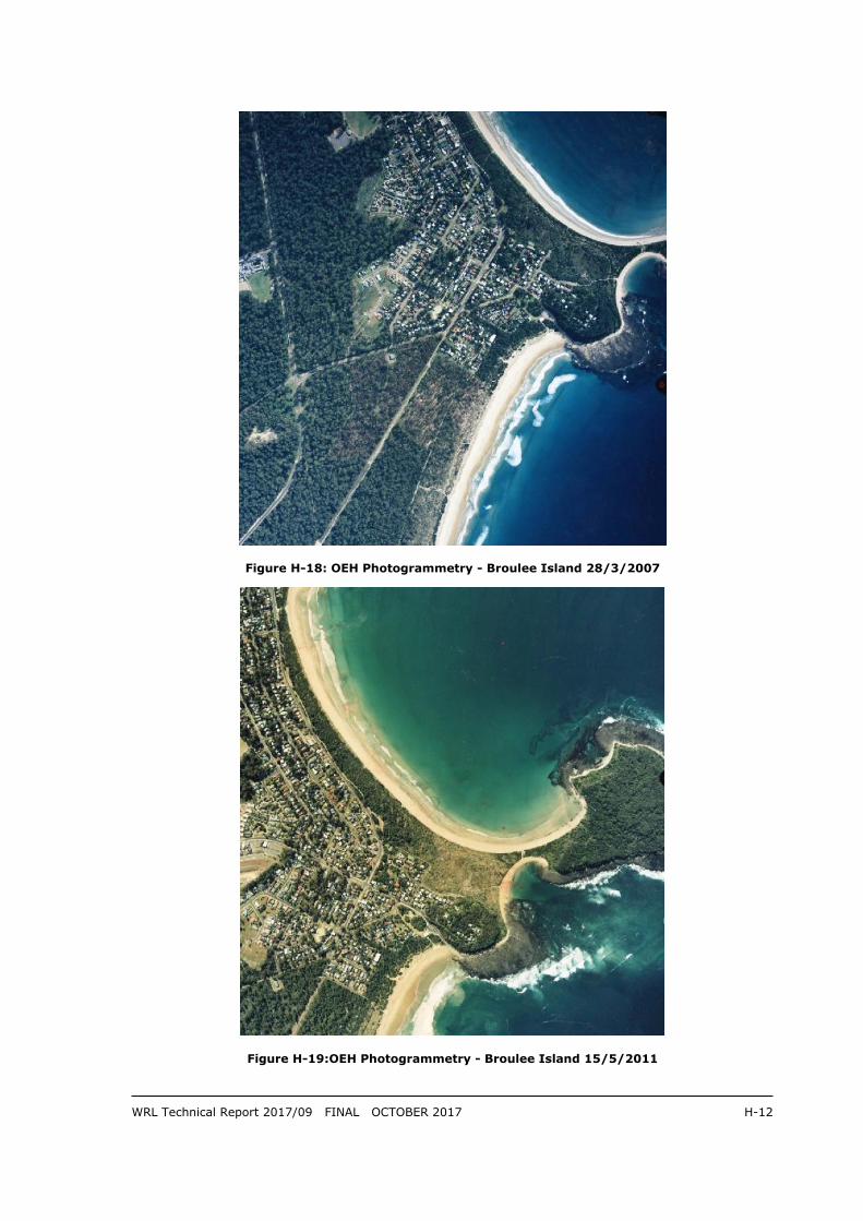
28/03/2007 Connected Vegetated OEH Aerial Photograph
15/05/2011 Connected Vegetated OEH Aerial Photograph
8/12/2012 Connected Vegetated WRL Site Inspection
24/02/2017 Connected Vegetated WRL Site Inspection
Based on the histories presented in Table H-1 and Table H-2, Broulee Island has been
disconnected three to five (3-5) times between 1828 and 1901 (73 years) and three (3) times
between 1961 and 2017 (56 years). While significant gaps in the dataset are acknowledged, on
average, the tombolo has been severed approximately every 15-25 years. At the time of
writing, the island has remained connected for at least 28 years. There is not enough evidence
WRL Technical Report 2017/09 FINAL OCTOBER 2017 H-3
to confidently comment on the varying length of time that the island may be disconnected for,
following a breach, but it is noted that, following the breach in May/June 1974, a tombolo did not
reform until late 1980/ mid 1981; a six to seven (6-7) year duration. Note that WRL has made
no attempt to estimate the varying volume of sand released into Broulee Bay when severing of
the tombolo has occurred in the past.
On 24 February 2017, WRL undertook a cross-sectional survey at the approximate narrowest
point of the tombolo. Ground surface elevations were measured using a Trimble R10 RTK-GPS
and offset using the NSW CorsNET network. The transect had a volume of 159 m3/m above
0 m AHD and is shown in Figure H-1.
Figure H-1: WRL Survey of Broulee Island Tombolo (Facing West)- 28/02/2017
In addition to the present connected state, WRL has also considered the scenario of
erosion/recession of Broulee Beach with Broulee Island disconnected in this report. Such a
breach would almost certainly be initiated from the southern side (Bengello Beach). WRL has
not undertaken an assessment of the potential for a breach to occur on the present profile.
Detailed modelling of the potential for a breach would be complex as it involves interactions
between wave runup, wave overtopping, cross shore erosion, longshore processes and
vegetation. It is noted that the nominal design storm demand for the centre of Bengello Beach
(170 m3/m above 0 m AHD, based on erosion measured during May/June 1974) is slightly larger
than the volume currently in the tombolo transect. However, the present profile appears to have
more volume and is heavily vegetated in contrast to the un-vegetated state of the tombolo prior
to the May/June 1974 storm sequence (Figure H-5). Indeed, the tombolo is now in its most
heavily vegetated state since aerial photograph records began in 1961, which may contribute to
the lack of breaches in the last 28 years. However, WRL considers that it is likely that the
tombolo will be severed again at some stage in the future.
0
1
2
3
4
5
6
7
0 10 20 30 40 50 60 70 80
Elev
atio
n (
m A
HD
)
Chainage (m)
Broulee Bay(North)
Bengello Beach (South)

WRL Technical Report 2017/09 FINAL OCTOBER 2017 H-4
Figure H-2:OEH Photogrammetry - Broulee Island 1/8/1961
Figure H-3: OEH Photogrammetry - Broulee Island February 1964

WRL Technical Report 2017/09 FINAL OCTOBER 2017 H-5
Figure H-4: OEH Photogrammetry - Broulee Island 7/1/1969
Figure H-5: OEH Photogrammetry - Broulee Island 6/4/1972

WRL Technical Report 2017/09 FINAL OCTOBER 2017 H-6
Figure H-6: OEH Photogrammetry - Broulee Island 10/9/1975
Figure H-7:OEH Photogrammetry - Broulee Island 11/3/1977
WRL Technical Report 2017/09 FINAL OCTOBER 2017 H-7
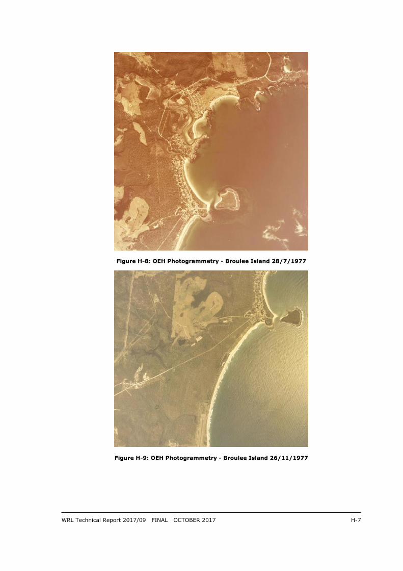
Figure H-8: OEH Photogrammetry - Broulee Island 28/7/1977
Figure H-9: OEH Photogrammetry - Broulee Island 26/11/1977

WRL Technical Report 2017/09 FINAL OCTOBER 2017 H-8
Figure H-10: OEH Photogrammetry - Broulee Island 21/12/1980
Figure H-11: OEH Photogrammetry - Broulee Island 27/8/1981

WRL Technical Report 2017/09 FINAL OCTOBER 2017 H-9
Figure H-12: OEH Photogrammetry - Broulee Island 12/4/1984
Figure H-13: OEH Photogrammetry - Broulee Island 25/10/1988

WRL Technical Report 2017/09 FINAL OCTOBER 2017 H-10
Figure H-14: OEH Photogrammetry - Broulee Island 22/11/1991
Figure H-15: OEH Photogrammetry - Broulee Island 15/4/1993
WRL Technical Report 2017/09 FINAL OCTOBER 2017 H-11
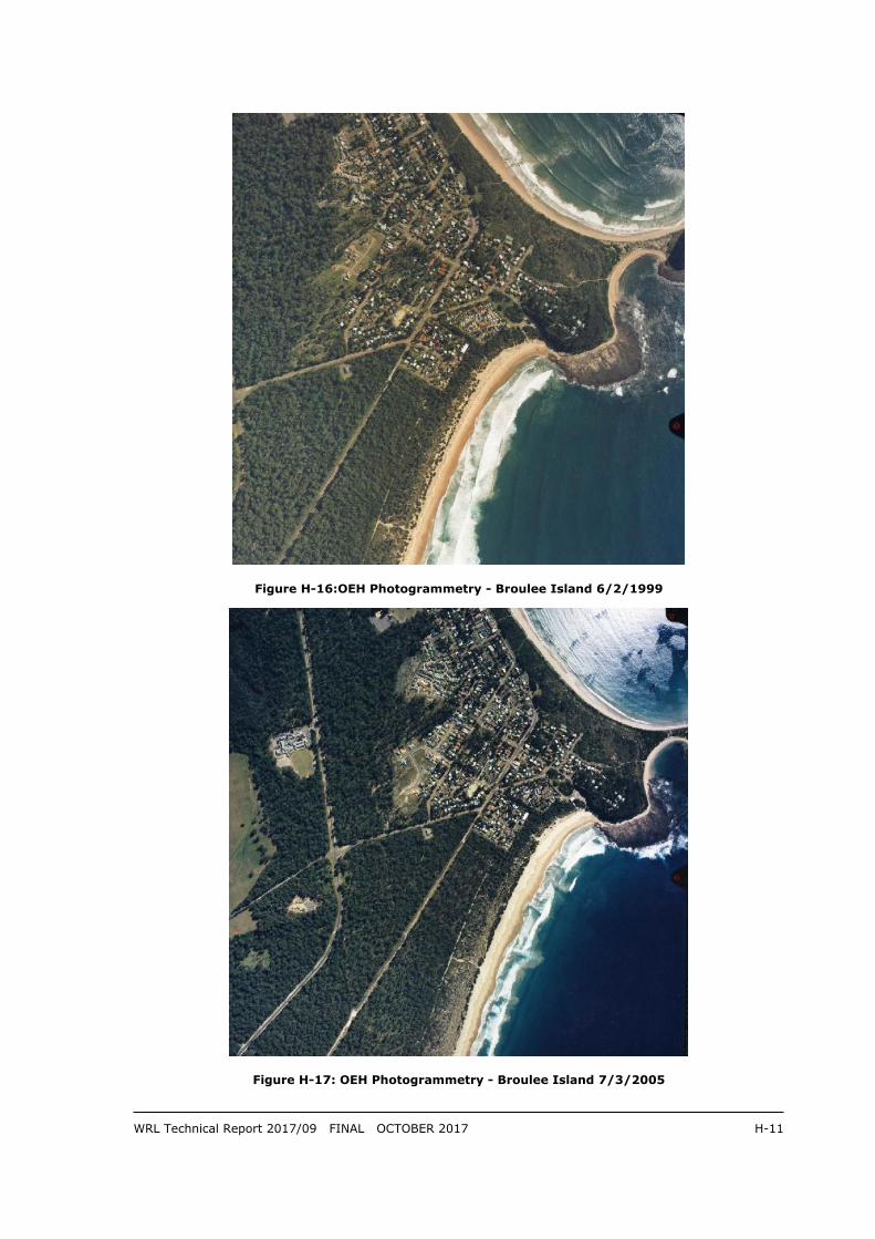
Figure H-16:OEH Photogrammetry - Broulee Island 6/2/1999
Figure H-17: OEH Photogrammetry - Broulee Island 7/3/2005
WRL Technical Report 2017/09 FINAL OCTOBER 2017 H-12
Figure H-18: OEH Photogrammetry - Broulee Island 28/3/2007
Figure H-19:OEH Photogrammetry - Broulee Island 15/5/2011


