
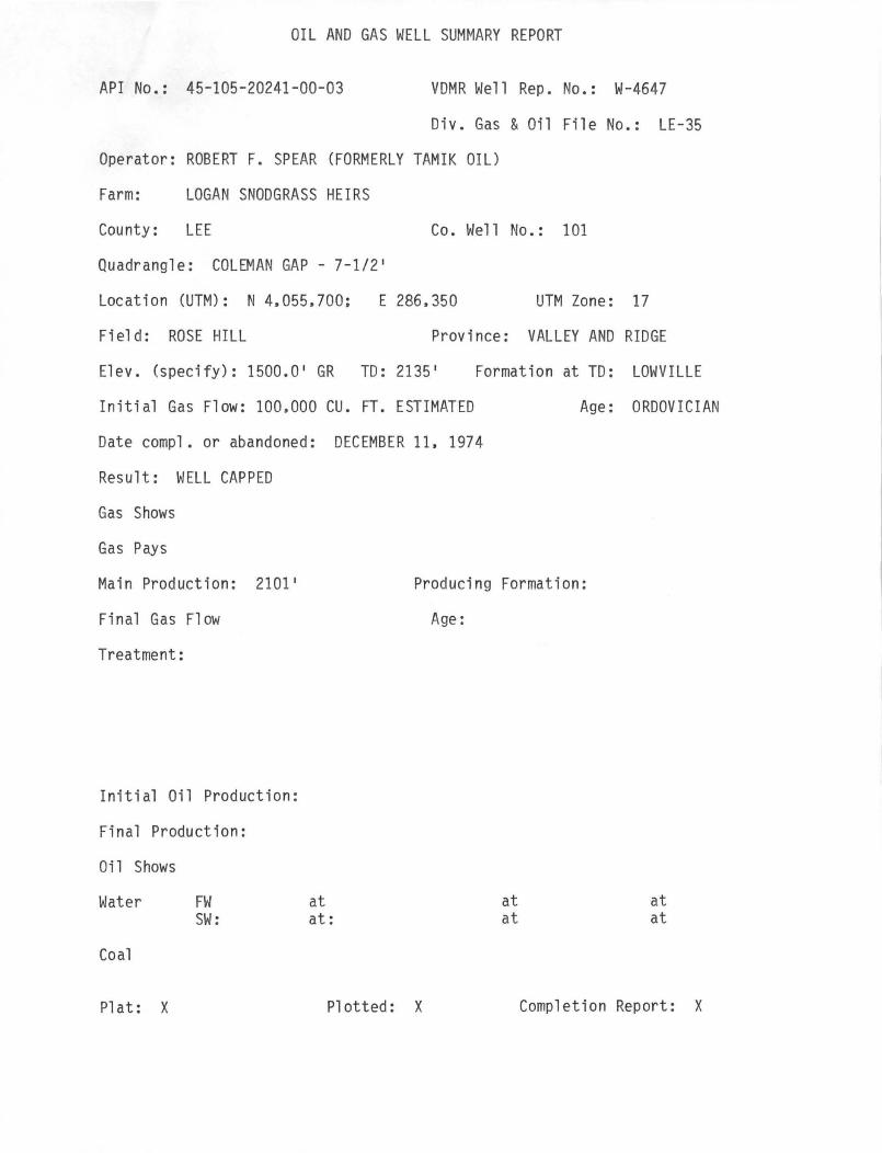
OIL AND GAS WELL SUMMARY REPORT COLEMAN GAP 1-31
API No.: 45-105-20241-00-03 VDMR Well Rep. No.: W-4647
Div. Gas & Oil File No.: LE-35
Operator: ROBERT F. SPEAR (FORMERLY TAMIK OIL)
Farm: LOGAN SNODGRASS HEIRS
County: LEE Co. Well No.: 101
Quadrangle: COLEMAN GAP - 7-1/2 1
Location (UTM): N 4.055.700: E 286.350 UTM Zone: 17
Field: ROSE HILL Province: VALLEY AND RIDGE
E1ev. (specify): 1500.0 1 GR TO: 2135 Formation at TO: LOWVILLE
Initial Gas Flow: 1000.000 CU. FT. ESTAMATED Age: ORDOVICIAN
Date comp1. or abandoned: DECEMBER 11. 1974
Result: WELL CAPPED
Gas Shows:
Gas Pays:
Main Production: 2101 1
Final Gas Flow
Treatment:
Initial Oil Production:
Final Production:
Oi 1 Shows:
Water: FW: SW:
Coal:
P1 at: X
Producing Formation:
at: at:
Age:
Plotted: X
I .)
Completion Report: X

Drillers Log: X Geologic Log:
Samples : X Interval Sheet: X
Sample Interval: 01 TO 2135 1
Geophysical Logs S. P. Res Gamma: X Neutron:
Density: X Sonic Other: TEMPERATURE
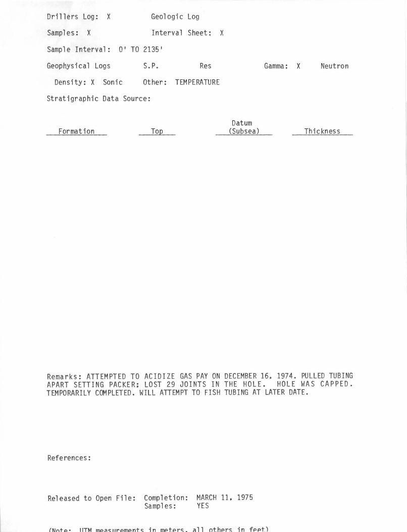
Stratigraphic Data Source:
Formation Datum (Subsea) Thickness
ot-l ,C.! I~
Remarks: ATTEMPTED TO ACIDIZE GAS PAY 0 DEMBER 16. 1974. PULLED TUBING APART SETTING PACKER: LOST 29 JOINTS IN THE HOLE. HOLE WAS CAPPED. TEMPORARILY COMPLETED. WILL ATTEM·PT TO FISH TUBING AT LATER DATE.
References:
Release to Open Fi le: Completion: MARCH 11. 1975 Sampl es: YES
(Note: UTM measurements in meters. all others in feet)

< COLEMAN GAP
1-31
VDMR Well API No. __ 4~5~-~1~0~5-~2=0~2~4~1_-~0~0-~0~3~ ___ ___ Rep. No. _--'W .... -__ 4~61.,;l4u.7 __ _
DHQ Fi 1 e No. _--"L ..... E ..... -"""3~5~ __ _
Operator ROBERT F. SPEAR (FORMERLY TAMIK OIL)
Farm LOGAN SNODGRASS HEIRS CO •. He 11 No. -.,;1;;..,;o;..,;1:...-____________________ _
County LEE Quadrangle COLEMAN GAP - 7~'
Location (UTM) _N;;...4~, 0;;..;5...;;5~,~7~0..;..0 ___ E...;;2...;;8...;.6~,~3.;;,.50~ __ UT~1 Zone _....:1;;..,;7 __ _ (Lat. and Long.) ____________________ _
Field ROSE HILL Province VALLEY AND RIDGE
Elev. (specify) 1500.0' GR TO 2135' Form. at TO LOWVILLE
INITIAL FLOW - 100,000 CU. FT. ESTIMATED Age ORDOVICIAN
Oa te comp 1. or a ba ndoned .......;D;:;..E;:;..C.;;..;E;.;;.;M;;;.;B:..:E;.;;.;R;:-....;;1:..:1:....l,~1:..:9...:.7~4~ _________ _
Resul t WELL CAPPED
Gas Shows ----------------------------------Gas Pays Main ProGuct1on __ 2_1_0_1_' ______ Prod. Form. ________ _
Age ________ _
Treatment: ---~------------------------------------
--,-------------------------------------In iti a 1 Production ______________________ _
FINAl, FLOW
Oil sho\'IS ___________________________ _
\'/atel" FW at at at -.--- --- --- ------ ---SW at at at ---Coal ______________________________ __
Plat _""""X"--_ Plotted _~x~_' Completion Report ___ ~X _________ _
Drillers log X Geologic log __________________ _
Samples --'X""--_ Interval Sheet __ X2.-_
Samp 1 e I nterv a 1 ~0!...'-----!T..1.0!_f2...!1~3...d.5_' _________________ _ Remarks ____ ..-.:. _____________________ _
Geophysical logs S.P. Res Gamma X ---- Neutron ___ _
Density X Sonic Other TEMPERATURE;

, -.. I'
Stratigraphic Data Source ________________ ...._---
Formation · Top Datum
(Subsea) Thickness
~arks ATTEMPTED TO ACIDIZE GAS PAY ON DECEMBER 16 , 1974
PULLED TUBING APART SETTING PACKER; LOST 29 .TOINTS TN
THE HOLE. HOLE WAS CAPPED. TEMPORARILY COMPLETED WTT.T .
ATTEMPT TO FISH TUBING AT LATER DATE .
References ______ ~ ________________________ ___
Released to Open File: Completion __ M_A_R..;;,C,;;,,;H~1..;;l;..o:,.....;;1;,.;;9;...;7;...;5;.._. ______ _
Samples YES -------------------------(Note I tJl'M measurements in meters, all others in feet)
OIL AND GAS WELL SUMMARY REPORT
API No.: 45-105-20241-00-03 VDMR Well Rep. No.: W-4647
Div. Gas & Oil File No.: LE-35
Operator: ROBERT F. SPEAR (FORMERLY TAMIK OIL)
Farm: LOGAN SNODGRASS HEIRS
County: LEE Co. We 11 No.: 101
Quadrangle: COLEMAN GAP - 7-1/2 1
Location (UTM): N 4.055.700; E 286.350 UTM Zone: 17
Field: ROSE HILL Province: VALLEY AND RIDGE
Elev. (specify): 1500.0 1 GR TO: 2135 1 Formation at TO: LOWVILLE
Initial Gas Flow: 100.000 CU. FT. ESTIMATED
Date compl. or abandoned: DECEMBER 11. 1974
Result: WELL CAPPED
Gas Shows
Gas Pays
Age: ORDOVICIAN
Main Production: 2101 1 Producing Formation:
Final Gas Flow
Treatment:
Initial Oil Production:
Final Production:
Oil Shows
Water
Coal
Pl at: X
FW SW:
at at:
Plotted: X
Age:
at at
at at
Completion Report: X
Drillers Log: X Geologic Log
Samples: X Interval Sheet:
Sample Interval: 0' TO 2135'
Geophysical Logs S.P. Res
Density: X Sonic Other: TEM PERATURE
Stratigraphic Data Source:
Format i on Top
X
Datum (Subsea)
Gamma: X Neutron
Thickness
Remarks: ATTEMPTED TO ACIDI ZE GAS PAY ON DECEMBER 16. 1974. PULLED TUBING APART SETTING PACKER: LOST 29 JOINTS IN THE HOLE. HOLE WAS CAPPED. TEMPORARILY COMPLETED. WILL ATTEMPT TO FISH TUBING AT LATER DATE.
References:
Released to Open File: Completion: MARCH 11. 1975 Samples: YES
(Nnt,,· JlTM m"~C::"Y'''mpntc:: in mptpr,,_ rill othprc:; in fppt)

· .... ' ". ',"'. 0 IL ., AND GAS ~/ELL
, SUft.:·1ARY REPORT :
, API No. , 45-105-20241-00-03 '
VDMR Well Rep. No. __ W_-_4_64_7 __ _
DMQ File No. LE-35
Operator ROBERT' F. SPEAR (FORMERLY TAMIK OIL)
Farm LOGAN SNODGRASS HEIRS
Co., Hell No. 101
County ____ LE_E ___ ~7~<t7J~-_ Quadrang 1 e _C_0_L_EM_A __ N_G_A __ P_---.,;...7 -....:1:!../~2_' __
Location (UTM) N 4,055~ E 286,~3~o un1 Zone 17 ~-~-~,~;----~-~~----- ------------
(Lat. and Long.) __________________________ _
Field ______________ ---:Province VALLEY AND RIDGE
Elev. (specify) 1500.0' GR • . TD ,. 2135' INITIAL ' FLOl~ - 100,000 CU. FT: ESTIMATED
r J" , " l· · T . r '. . .
Oat~ . compl .' or abandoned . -~ECE~~ER 11, 1974 --~------------------------
Form. at TO LOWVILLE ---~~----
Age ORDOVICIAN ------"-~-------
Result' .. WELL CAPPED
Gas ' Shows ------------------------------------Gas ' Pays '
Main ProGuct1on 2101' p,rod. Form. -------------- --------------; ,
Age _________ _
Treatment: -----------------------------
Initial Production -----------------------------------FINAL FLOW .-
Oil shows 1700'
l'/atel'" FW at at at -- ---- ---- --SH at at at --
'. Coa1. ___________________________________ __
Plat X Plotted X . ' Completion Report _-..;X~ _____ _ Drillers Log X Geologic Log _________________ _
Samples X Interval Sheet X Sample Interval __ 0,;.,' '-...;;.t.:;...o...;2~1.;.35.;,..' ________________ _
Remarks ___ .....:.. _______________________ _
Geophysical Logs S.P. Res Gamma X Neutron -- -- -- --Dens ity __ X_ Son i c Other _...:..T~EM..:.;..P...;;E~RA..;,;T;,.;::U..:..:R;:.,E ;~ _______ _
I, I
Stratigraphic Data Source __ ~ ________________ _
I .
Formation · Top
V- : I " I
Datum (Subsea)
,- I" ,,.
I . ' . I ~.. ..
Thickness
Remarks ' ATTEMPTED TO ACIDIZE GAS PAY ON DECEMBER 16, 1974. PU~LED ·· TUBING APART SETTING PACKER; .LOST29 ,JOINTS IN THE HOLE . HOLE WAS CAPPED, TEMPORARILY COMPLETED. W[ LL ATTEMPT mO,FISH TUBING AT LATER DATE.
References _________________________________ __
Released to Open File: Completion __ M_A_R_C_H_ll_,_1_9_75 _________ _ Samples .. ___ Y_E_S ___________ _
(Note I U'l'M measurements in meters,' all others in feet) I
. ' • • ,. 11.., f , 'j'
., ,
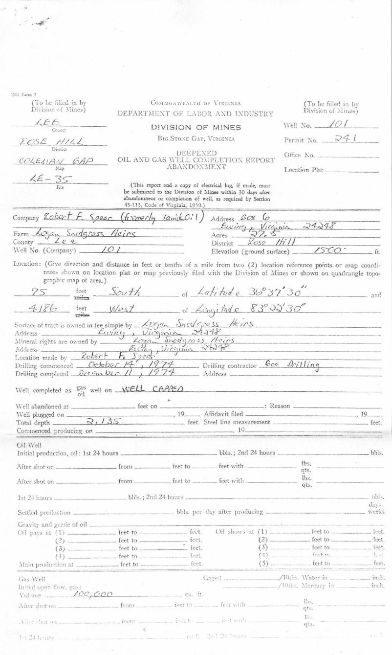
D:·i r .}rm 7
('i"o be filled in by Di'. is;ur: or )'Ii:les)
./££ _ _ ___ ::-:c ____________ _ Co:..nC~i
CO.\L\IO:\WE.\ LTH OF YLRG[XIA
DEPARTMC\T OF L\BOR :\,\"D IXDUSTRY
D1VIS10N O F r."l !NES
Bre SrO:\E GAP, VIRCI);,IA
DEEPE::\ED OIL A:{D G_-\S \\"ELL CO)'[PLETIO'\" REPOR.T
AB:\XDO'\" ,),IEXT
(This report aod a copy of electrical log. if made. must be submicted to the Division of Mines within 30 day> after abandonment or complecion of wei!, as required hy Section 45 .. 11 3, Code d Vi,gillu, 1950.)
Address :SOX (0
(To he fdler: in by Division uf }lincs)
Well 1\0 .. _--L.'.".O:::.,...,:/ ___ _ _ p . v 'JL..:t I . enmt .,,0 .. _~_r_. _____ _
Office L\o. ________ ._._
L ocation Plat
c.' 1/" " _?A "\ //!: ~~~-~~~£}0~~~)~IA~. ____ ~~~~~~Jtti~~ __ ,---_________ __
Acres C22· ~ F2. rm 2L--::rhl~cd.Clrcss Ihics \./L u Coanty . -<c."."_~",,~,--_ _____________ _
\ Yell ~ o. (Company) __ ---L./...::O:::........lI'---_______ _ District -.J:.QSr/ ;f7' II Elevation (groand surface )
Locatioil : (Give di rection and distance in feet or tenths of a mite from t\\"o (2) location reference points or map coorcinatb 3r.own on location plat or map pre\'iou :;ly fi led with the Diyis lon of :lVIines or shown on quad rangle topographic map of area.)
~~ _--,,=S-=~-;-"-~ot_ f:.......:-;{<-I _ ____ of _ 1..C1 U~ E-3&:.) ~:1 ~ ;3""-'0""-...1_/ _ _____ _ _ and
A ' .-- ( f / '..L' p,:)o ", ," ]0'/ :-"f- /cY ': feet )Ale s ~ of _ A.. (:It;:-iLPd ,£ (,) ;,) V~ , . ____ ----,,.-___ _
~ ..J
Snrbce ot tract i, o\'.-ned in fee simyle by --<?{)(~.~. cS;] c~.S-:.s=---L./Ie:..;· ·==-·"-'/~'-·\-".s"------------------!\(!Ci r~ss CIt 'Nt (1 ) UIiJ'x"",,-- 0;" L~'-"?'---_.---::-'Iineral rights are owned by 'J 4ft''''- :;r:?d~:Y1-:§l..i'.f.(' {/:s ;\ddre~s "> l ' - F2 .. :ctl!j~,jI'j'h.\ (L- ~J4.JL'rrf T t ' . b Le· Yl ('T F; j oJ,z., t" _~OGllOn n12.ue y _ _ ______ -:;;:-__ _
Drill ing cOlmr~encerJ Q,:-fchvl" 14 ~ I / '77-1-- Drill ing- contractor Go<~ J)/~/ If :"/\3 Driiling completed {),7 c 0',... , tn ,'" // ; / 9? 1- Address
aas on " "'''"'LL C A "l1\L:- /\ \ Vell completed as " '1 well -¥JIJ--' rr.c 1.1 O!
\Vei l abandonee! 2.t _________ feet on _________ : Reason --_________ _
Well plugged on _._ __________ ____ 19 __ Affidavit filed -----------__ _
Total depth ~,I-! -'/~3""',,..s=<___~ ______ feet . Steel line measurement .
, 19 _ _ .- - - _ _____ ___ feet.
Commenced producing on . 19 ___ _
Oil W ell Initi8.1 production, oi l: 1s t 2-+ hours ____________ _ bbl:;.; 2nd 24 hours _________ ~-_ _ bbls.
After shot on ______ from _____ feet to ____ feet with ______ _
Afte:- shot on . ___ ____ from __ _ fee t to ___ feet \"ith " ______ _
lbs. qts. Ibs. qts.
1 st 2-~ hour,; bhIs. ; 2ncl 24 ho~!rs ----------------------
Sett led prOclll C~i() rl bbl:;. per clay after p;-odllcing dav.;:
____ w/ek')
Grzr\'ity 2.ncl gr;lc\e ot oil (H P',v;; at ( 1) _____ fee t to _______ fee t. Uil sho\\':; at (1) feet to _____ keto
(~) _______ fee t to _______ i <,et.
(3) . ____ feet to __ ' _ feet. ( 2) feet to feet. e 3) ----.. ----- feet to _____ fee.
( -1- ) ________ feet to __________ . rpet . « (~) _ t"f. t'".~; c ~
:\bin pruril!ction at _____ fee t to ________ feet. e 5) -- ---_ --- - feet to ____ . " __ feet. ===== ._- ------- ' .. _-------_._----- -,-- - -' -.-.------ -.- -.-------- ---- -
rn;~ia~ open 11 0\\-1 g='. ::;i : \'"(.1-.1'1:e ____ . __ . / QC2;..t.::...c..f2... __ _
i\~ l t:r silot ,, :1 ___ . ____ . _____ f r :1111 ---
~ \ ; t __ _______ __ f rUil1 ___ _
1 •. : ~ 1:1 .:~,.. ~
__ cu . it.
C;\(:,;~'d __ ____ _____ / IOclt ,-;. "'akr ill _ _ __ iner:.
, 1 ") I
________ _____ /!(Jdl, . . \krcury in __ . _ ___ j n~h ..
I; ):;. qt~., _

R ock pressu;-e : Jl;i l ial lbs. ; :lfter lWlIl' '; lbs. Settled product ion cu. rt per dal' 3' lC'r producing
days
G ;)S pays 'at ( 1) feet to feeL G.,,, 0 110 \ \ -'; :i t (1) feet to fet' . (2) feet to feet. (2) fect (0 --___ feet. (3) _. fe( t '0 ~ :... ~t. (3 ) ftct to ftel. (4) feet to fect. (-1- ) fee t to - ____ feet.
:\Jain production _;d_Lf2 I fect to- itet. (5) fcet to - ____ feet.
F resh water at (1) _____ fl!et, _____ GF:\I; (2) ___ feet, GPM; ( 3) _ __ feet, ___ GF\I. Salt \\'ater;)t (1) feet; (2) feet; (3) fed; (4) feet. ' Cual: from - ___ feet ____ inches to feet ___ inc11es; from ___ feet inches to, __ _
fcet - ___ inches ; from ____ feet lliche5, to feet inches. Well acidized from _____ feet to _____ feet with _____ (quantity) of acid.
from _____ feet to _____ feet \\'ilh _____ (qu antity) of acid . from _____ feet to feet ,yith _____ (quantity) of acid.
Remarks:
. :1 C ASING AND T UBI NG 11 PACKERS
I !I
I SIZE USED IN L EFT I N P ES FOR..'I.TED
11 .Kr~D S I ZE SET .-\.T I'
DnrLLI~G " ' E LL " ~ 1 ;
(inch) (feet) (feet) (feet) t.o (feet) -ii LO 30 3 0 I' I gSb 3 41 .34J Ii
11 I , I
I \ \ ,
" L I ::\£RS ,
I SIZE Ui;£:D IN L£:F'£ I::\ PER FOR_H>;:D DPJLLIXG " 'ELL
-(inch) I (ft. ) (ft.) (ft. to ft.)
i ;
I I : . Casing Cemented: _____ inch. from _____ feet to ___ _ _ D ate ______ _ ______ _
____ _ inch. from fe et to _ ___ _ D ate _____ _ _______ _
_____ inch. from fe et to Date
R emarks : (Shut down, depth s, dates ; fi shing jobs, depths, date.s; caving; other notes ) ttrrclt1,f7t;() 7D IjCtj) 12E GM A1'1 1;;;;'-/0-24- , tJL1LL£O TVtf1ltj6 Mn/(.T sEmN6 PAC.U IC-, LoST :::y:J S OI/li75 iN 1fc>~t5. ito£..E. CrtPP60, 7"£:AIPilfLltR IJ .. J,/ C(}I:/lk f![,:5L) .. W ILL ITT"r/3!1IPr 7Q FiS H 7] lB/A){;t A I J..ft7f./t..=,--=---><O~ft7£-,--,--,1 ~, ____ ' ______ _____ _
Samples or cuttings will be available {or e..xamination by a mej~~ber 0;: ~l:e \ -irginia Geological Survey ~~~?
'Will be fumished the Virgjnia Geological Survey upon request ( -~~.'j ,if sacks for same are {urni,:hed by lhe iy,:.r--)
Sun-ey (Yes) (j9iJ..)
Electrical log n~ade ,/ or not made ___ (check \,.-11i ch.) Copy furnish ed herewith y£S or will he submittr:d on r;,' by --7r--::)---'/'--:-,;;)---...</---'-../ --------, 19_7_1-_ Depths ,G1Mrl-ld- Rd1 J)£f,)5/7"1 ~ Cd.Llf't-K: . 0 - '?:\ , IS
<T-c . , 1\ ... ff)' _ _ ..... 1 i S- / i 1.~ ... mr E/Cr1T!1.I...e. ___ -::--____ \.: / -::{ ... J.01ICE(1)£Ll2....4.c;L."--..:.='--O::>.<.....>0~___ c7 - ~ 1l ·S-"
The operator reqcests that information given herein and log or lo;;s D.:: kept conndential for a period of ninetr U;1YS alte r
completion of the well co\'en:d by thi s report ~1K}
"'" ~

.. . ., .
, " ~ .. ~ '.
Well Xo. _ _ .......:.1 ____ _ File Ko. Lc - 3S- Permit ' 0 , ---=;;)~-q..-":'·---II ____ _
LOG
FL!rnished by __ -_ Date ___ _
Compiled by _____ _ Date __ _
S .U(PLE IhnD OR Top I BOTTO~ ( TJ[IC~'q:;;5 RE:\fAP. -
No. FOR..ILI.TlOX Co LOP. SO~FT Cfept) I (f.:et) (feet) OIL, G.\S
I \\TAT E: R DE
SHc'l' Do.
r I FISHlXG, E
CL.JAJTCI\! SoFT (() ~4S- ~4S I
CLINCH t/71/C{J v: "\
I 51L.LlfU A fJ ( PDG!t II Itl..L6 '1
1m/co ;;)40 137;;) /-;) 7 RlrN£ Alir4.0~4
I ~memu SHJ
7 /'1B.) ,. '''7';). I -<fS-O 78 1~1 CAIc3.6,z .:> •
I I ,
$£QLfn:rCril E:. I .-11 E() r '4SV ! 7/1- ;::)04-
/l~&.l 5 V ) ~(E I I I ;t 1 Ef.). ? /4- 1/0705- 3 b t ! I I I I I
71LftJl7J tV I Hn fCD /07,'::::;- ' 100 r;; .-:;-93 I I
, PTW
'I'C.
i
£(oGL£S7DfI[ A -I £LJ • /(",&~ ! IP~4- IS-Co CI" 5Hcl!l I
I
V / 700 I
/ L~()(cItSI tJ I I I
I RDCVICt ft./\! I eoto'l tK£E4 A-t eLl. 17.;}4-; ,Q44 / d. 0 mEil;\BEfL I '8E(I/ H~j/t)
I
i r0" f:fttt36fC 4'1 £{J ,144i ;JoQJ7 1;;-1-
LtJW V/1..L E.. /ff1ZlJ ~Oq? ~J"3~- 37 GAS ~ I
£51" /0 I 1:/) .. \.
, 10 f
OA'iCF I I
,
I I i
I I I I I
I
I I ! ! I
I I I I
I I
I I
I
I I
I ! ! ,
-I
THIS FORM MUST BE SIGNED BY AUTHORIZED PERSON:
~ " ' ... .
.. ( ~ '..J
(1'0 be fill ed in by DiyisllH! oi :\Ii nes )
- / E:£.. . - - -- - ---..- -------- -- --CO:J~tj"
CO.\D W:" IITM.TlI OF Y[ RCH, fA
DEPART!\I E :\"T or L -\ BOR A _ TD I'\"DUSTI~Y
D!VISION OF t,,11N ES
BIC STO~I:: GAP, VIRc r "IA
DEEPE0:"ED
(To he ftl led in by Division of Mines )
W ell Ko . /01
Permit Ko. ;;:)4 1
Office Ko. OIL AXD G.-\ S \ \TLL CO:\[PLETlON REPORT'
ABA~DO:\" ~IE:\"T Location Plat ______ _
____ ~E -=-3.~. Fi:. (This report :lod a copy of eleCtrical log, if made, must
be submitted ro the D ivision of Mines within 30 days after abandonment or comple tion of well, as required by Section 45-11 3, Code of Vi rg ini:;., 1950.)
Adclre3s (0)( Co c.' . / - , .
Farm ..lQ.j.J.~ ~rJC;,"':" ss vL .J
--..!d.& /// ') f'1 '2// 11'40 (t\
A.cres -~ ~ r:-,,---- ---------District ~(""";..LS,;...(·~ _ _'!CL1z..L...J.' /~'/, ___________ _
Ill' irs Cou ntl' -f'_-_~-,,=,,-. ________ _
\ \"e1l :\0. (Company) ___ L..I-=O~ .... I ____ _ Elevation (gro<1I1cl surface) _ ---</c.......:,,!YCQ • it.
Locat ion: (Gin: direction ancldistance In fee t or tenths of a mile fro m tIro (2) locat ion reference points or map cQ(J rdilnte~ ~r.(;\'.- n on locat ion plat or map prt':iouol y fi led \I:ith the Di\·i s:on of M ines or shown Oll quadrangle to~o· """T'1,: ~ l"~l) of "rea) :::> 1<..- 1 ).· ...... c. u..
___ . _~:J· I X" (__ ree t )!fit·.5 t _ or ~)Y); 10LL- W(-~ ~;;Y":lci_'/ _ __ _ ~ J ------------
c;u rf:::.c.: of tr:'oct i, oil'ned in fee simole by __ '([{;(l ,- ~);l n~tYi.s.s /icl>.s c ~ ~" . ~~~p :\c!dr~ss (( '.'llCf ) UfC~p.D,L-~x..:~_c-___ . _____ _ :-li nera l rights C!re O\\'l'!ed by ',} ~011",- S) \(. d::'Lr~j'-..!'./l'W-'·f".5. _________________________ _
IT. v , - ' ;,1 . y~"\-1 -\clcl,-c"'; y-j ·j.'t ll <::.. V' ('~U1..~ "" . "' ~ • " . - ' > . . J.t-. "+ r j ' ,.J-:r -'-J --.----. - ----------L ncalirJI: m<'.dr I}I' /.. . ~ )~ I , _-'-r.-zi'----'~''-) -'-\, ..,.".,_'-:.' -,;;;-____ _
Drilling comi~:encecl ___ Q dcfJ\-:i 14 r I 197-1-Dri llillg completed ,,'] .. ' c C h ,-b~1 ; /971
'\Vell ccmIlleted 2.S g~ls well on _.~!.£-,-.L CA2,~t) 0,
\Vell abandoned C.t _________ feet on
D r ili \ n~ contractor Address
_________ : Reason __ __
W ell plugged on _____ -=-_________ 19 ___ Affidavit filed -----------_ ___ , 19 __
Total depth ____ --'~=:>_,I__! -'1,-,030<...""s=«--__ feet. Steel line measurement feet. COlrmenced V'oducing on _____ . _________ ______ , 19 _________ __ _
Ot! Well I nitial prc:ductio,l, oil: 1st 24 hours _________ _ bbl:;,; 2ncl24 hours _____________ bbls.
After shot on ______ from _____ ieet to ____ feet with _____ _ Ibs. qts. Ibs. feet to ___ feet ,,-ith _ _________ _ q t,;_
Afte, shot on __________ from ---
1 "t 2-1- hours ____ _ bbls ,; 2nd 24 bO~ir~ bbls. day.;
bbl:;. per day after producing ______________ weeks
Gr;n'ity and grade of oil Oi! P;T' at (I) _________ feet to ___ . feet , Oil sholl's at (1 Y ______ feet to __ . fee t.
(2 ) feet to {~' e t. ( 3) _ _ feet to feet.
(2) feet to fee t. (3) ________ feet to feet ,
( -I-) _______ feet to _____ feet . ( 4) _ feet to ______ fef:t.
,\ [': i ll I'wd t:cti ,-,n a , fed to __________ icet. (5 ) ______ _, _ feet to ____ ___ fu:t.
C; a ~ ,\ \"eli GaL;'t" rl ___________ /lOth:,. \Vatf! r in _________ _ inch.
rn i ti l l~ optn tl r'l\\-, t!~~: _______ . _____ /1 Oths. :'.lercury in ____ inch.
Vu l:tlllC ___ .. LD~(1'--'O~------ _ _ Cll . ft.
,\it lT shot (I I ~ _______________ f r:ltl1 ___ ... _ ___ icet t., ___ . __ ie~ t I'.-i th - --.--------- Ills. qt,"; .
~ \ ;"t ,':--!" Ii I )i l __ ___ _______ ir l1111 . __ __ ___ _ _ :. d t · ; _
______ __ _____ CIl it.. 2nd 2-+ h Ol l r..; ___ _ Cll 1.

Rock pn:ssure: J lliti31
Settled product ion _
Ib:, . : 3ftn _ _______ _ 11l1ur:i ___ __ _ lhs_
cu. ft per tb y a:-trr Jl ruducing
Ga ~ pays at (1) fed to feet. G:!~ "bj\\-s ::i t ( 1 ) (2) ( .))
(-+)
(5)
_____ fect to _ _ ____ fee i: . (2) feet to _ ____ __ k et. fcC't to _________ fed. (3 ) _______ fec·t to ______ jeet. ______ feet to ____ _ _ f Cd.
(4) feet to _______ feet. ______ feet to __ . fee t. :-fain production _~LC2 I feet 10 feet. feet to __ ~ __ fL·c t.
F resh water3t ( 1) feet, GP;\I; (2) ieet, ___ GP.:\I; (3) ____ feet , GP.:\L S:llt water ot (l) feet; (2 ) feet; \..3) fed ; (4) feet. Cual: from ____ feet inches to fee t il ~ clles ; frolll ____ feet ___ inches to _ _ _
feet inches ; from ____ feet _____ inc-he,: , to feet inches. \Vell ac idi zed from feet to feet ,,-ith ___ (quantity) of ac id .
from ____ _ feet to _ ___ .. _ _ . ff'vt \\·jth __ (qlJ'1n tity) of ________ acid.
from feet to feet with _____ (qu3J1tity) of acid. Rtmarks:
~ , ij
CA" JNG A N D TUBI::\G :1 --------.-------------~---------------
PACKERS
SIZE USED IN LEFT IN PE::tFOJL-I.TED I ,
I' DI1JLLJXG WELL
,I
~
SET' _A..T S I ZE
(inch) (feet) (feet ) (feet) to (feet) -:i LO 30 ---.3 0 !! g-SZ2 'Y1:J .3 4 J
I Ii i I
----1-----1---------____ 1 ___ -
-
I Lr"ERS --
\
I I
F;;;:u IN DP.lLL1XG \YEU,
L~'l'T L, \ P I:Rl" ' ,n .\ 1 c:'l
====-._-~~I==============:============---!---------- __ (_il_1C_h_) _ \ __ <_ft_') __ 1 (ft.) =1 (ft. to it.)
I 1----------- -----,--------1
--1--1---:--=--=--=----:--.---\-Casing Cemented : _____ inch. from _____ fe et tl) _____ _ Date _____________ _
_____ inch . from fe et to ____ _ Date _____________ _
_____ inch. from feet to ____ _ Date _______________ _
Ren:3.rks: (Shut down, depths, dates ; 11 hing jobs, depths, dates; ca\'ing; other notes ) I3Tn:I!.-J.f it:O TO liC,OJ2 E Q.dS mv I~-I 0 - 7 4- . ,:Ji/LL £O Tvl OI/:/6 MAR:! S£m Nt7 1ft C.K4 IL- J LoST .::J 1 .JOJIl;75 j ,v IIc~L" Jfo /... £ C. irPP60 ) 7E;A I (J j)fc.!±R I L l/ C{ jA'/ik I!TM .. lL'ILL 1tTT£IIIPr 70 FIS H T)1£?J1v'{~ A I /. ftJt;te='--=-----"'OoLfr.!....7£~/ ~, ____ . __________ _
( Yes ) Samples or cuttings will be available for examination by a member of ~l'e Y irginia Geological Survey -------_ (~o)
\Viil be furni shed the Virginia Geological Survey upon request
Sllr.-ey
Electrical log made /' or not l11:lde ___ (check \'.-hich.) Copy lnrn ished herewith y£S or \\"i]] be submitted on Depths Qd.{!r'I(~R,11 1l£11../5/7'1 ~ Ct1l_ ft:?.E~
J£.A\ffit..fj'lli_tj~_-__ -:--___ _ j) I K. E:.( Tl DJLIj-"-'L..-"---'£-t-'=-<.Q.,.,,0"-'--___ _
(Yes ) ~
~-'[;.;} ,if sacks for same are ft1rni~hed by the
c ,- by r---=-----...:../-;;;):------=-I .:-I-------, 19 71-~!~ ;? l' ~~' ____________ _ (i - ~"2 i IS " 1-1 -~ t! 0 __ " __________________ _
The oi,erato[ H:'luesl s that information gi,-en herein and log or Jugs Lo:: kept confidential {or a period of nillety (bys a1 i.er
cGmp1tl ion of the well covered by thi s report ~i-~(/
t tt.,. . -,
.' ·" • •
1_- L .c: ? ... -Fiie ?\ o . . __ ' . L - oJ..)
LOG
Fl!rnishecl by -___ . _____ . Date
Compi led by
SA1{PL1; HAnD on Ko. Fon~UT10:\ COLOP. SOIT
--_.
( CL...IIJICA/ SoFT
C /.../NCI-f t/71!C{) V_ -"
.'S IL.L{iU A rJ ' pocrc illt£.L6 L/
L f:~I:'~) 1 I 1M/co I I Flc;j ,-fl-l f A I i3 .6 .z I
? '<c '" r;;: I ' 'r- ( tI "" /. iE!) , : .... 1,- ".,T J ": I I , I I ' I
i ! R~E.D5VJLJ .. EI i ;t 1 £[), I I I
/fnRD ! : r rc.f// ,rr II! I I '
I ) If ",0L£5,71' ""I i ./. 1 £LJ • I i I / ~- I(jC CA5! tV i I
~oO~' l ~!r 't j !
{ , ;... ~ If I If "" i tA.tD!.i t R.EEK-: I
I ,:t'l EL]. i ,1;) f AdJEfC. I I
~£N HIA{L) I i
I A\ E.).t/!;JcfL. 41 E./J
.. Lt? W V/1..L £. /fJ1-Z.{)
~ I
I I 1
I
Date __ _
T op BOTTO.\( THICKC';E:Ss (feet) (feet) (feet)
H. ElL-\ ftKS OIL, GAS,
\YAT £n D "'"","" Sn IT; D;~'~ '"
1 ______ F~rsm;-;G . }~·tc.
o ~45' ~.<1-S
:2~~ ! :37 ~ 1 /:) 7
1137~ i 1-50 ! 78 , I 14 ,)"(,) i 7 i1- ! ;:) H -
i? /4- 1/078-1 3 b r
i I
I /D 7,,> ' /~.{., F ! .~ c; 3
; I I /(~0'g ~ /j?~41 / seo I I , ,
I ! Ir~4- , ,Q44 I / ;) 0 I I
1/'1441 ;;)0'i'J7 I s-4
b 01.1" I ~ 13S'" 3 7 I I:D.-I
I I
I i 1
I
I
I ~ I
I
elL.. Slier/v 1 700
, GAS ~JOr
£ST: J 00 A·lCF

--::-:. -. : - .
.... , '"
.\ I 36 0 37 I 3D"
~ ! IV : ...c! ~ !
I ,
\4 Q .. -}
.. -:. .. " \..
~ \ \
\ \
\
\ ,
~ 17.,rA£ 1: -.
Q.
" "-
~
q ~ Q
~
; WELL Q No.1
.
\ \
\ \
. \
' . \
T-----__ r~#~-____ _
~ ~ .,;
. '
'., ff .' . ~ ,". ~ 1
, . I ' . I ~ ". ,
, ' . , : : "!
.'
-0 rt')
" .~I
-I •
.,
;- .. . . \
- - --- -- -:--.----------
CLE.V£
DEllA'
J.D&AN .5NDPG-A./Ul J-HNIJ
~ -•
r#"r---- , ----' . , , , , , , ,---
-' -_ - -;'oE
DEAN
Compon! TAMIK OIL COMPANY Addr~ B X 6 EWING Farh. LOGAN SNODGRASS
\ , , , \
COWMONVtfALTH OF VIRGINIA D~pt2rtmd of Labor and Industry
DlWJQN OF MINES AND G'lUA~IES _ .. Si, Stone Gap, Virglnfa
Tract Ac.res 27, ~_l..eaH No., __ ---I V.~IJ (Foran)~. 101 Serial No •. __ --+ \'tELL LOCATION MAP
EI~yQtlon (Spirit uvef)._.....;..15~O...;O~' ____ -I .if Filf NO. L E - 35 Quadran91e COL E MAN GA P , + Oa:.otes location of well on United states
\
Countl L utrlct RO S E H! L L topograpMc maps, scale 1 to 24 000 Jatitu~ . D OM Ionritvde IIn~ being rep"-nented by border
Engln3~r lines a. shown. En{.in:Jsr , Registration , .. OenoM one Inch IpacliS on border line of File No, !)roy.'ing No. original tracing.
, '-
[)Qte 1-23-74 "Scale 1"= 200 fv~Sc.o oEfJrlf .::: :)L)OO~ L. __ ' _~_r ____ ~ ______ .- ... -___ ~. __ --L-"!""':":":=':""'':'''=''''-'-::' .---'--'-------------'

DMQ Form 3 COMMONVvEAlTH OF VIRGINIA
DEPARTMENT OF LABOR AND INDUSTRY DIVISION OF MINES AND QUARRIES BIG STONE GAP, VIRGINl6. 24219
PHONE 703-523-0335
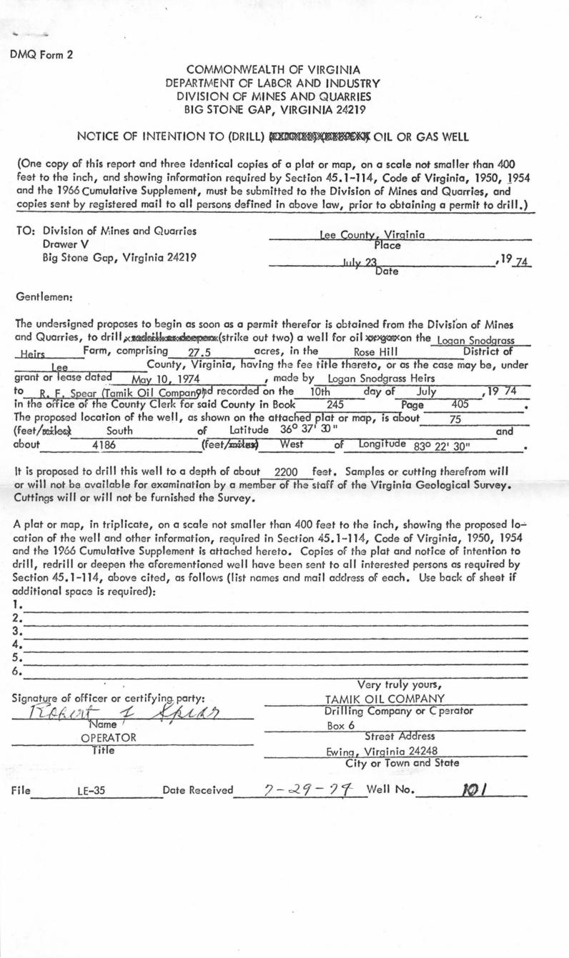
APPLICATION FOR PERMIT TO (Dl«ll) ~Il OR GAS WELL
(Required by Section 45.1-115, Code of Virginia, 1950, 1954 and the 1966 Cumulative Supplement. To be accompanied by Permit fee of twenty-five dollars and bond and surety therefor, as specified by Section cited. To be submitted in duplicate, one copy to be returned to applicant after action by Division of Mines and Quarries. TO: Division of Mines and Quarries
Drawer V Lee County, Virginia Big Stone Gap, Vir~inia 24219 . Pface
J •• ly 23DJtC;U Gentlemen: The undersigned hereby makes application for a Permit to drill,)t~}(Xxor~~)(strik~ out two) a well for oil or gas on the Snodgrass Heirs Farm, comprising 27.5 acres, in the Rose Hill
District of Lee County, Virginia, having .the fee title thereto, or as the -c-as-e-m-ay-....b-e-,-u-n ...... der grant or le~ dated May 10 ,19 -2£made by _ _ L_o-"g:o-a_n ____ _
SnodQrass Heirs to Robert F. Spear (Tamik Oil Company) and recorded on the 10th day of July ,19 74 in the office of the County Clerk for the said County in Book 245 page 405 • The proposed location of the well is shown on a location plat or map submitted to the Division of Mines and Quarries, by the undersigned, together with No/tice of Intention to Drill, Redrill or Deepen Q Well for Oil or Gas on the 23rd day of Jul 19 74. The proposed well will be known as \ e o. (l -A 0 Tamik Oil Company (company, etc.) It is proposed to dri" this we 0 Q depth of about 2200 feet. The proposed location is about 290 feet distant from the nearest property or lease line; about
feet distant from the nearest mining opening, or quarry (strike out words not applicable) a-n-d'7To-r-aTb-o-ut~3-90 feet distant from the nearestxki~, abandoned, ~e1Hk1g<;<~~>(~ (strike out words not applicable) oil C!P<5lB (strike out words not applicable) welt. There is enclosed herewith a certified che ck or U.S. Postal Money Order, in the amount of twenty-five ($25.), payable to the Treasurer or Virginia, covering fee fro a Permit to Drill a Well for eil or Gas, as required by Section 45.1-115, Code of Virgini.a, 1950, 1954 and the 1966 Cumulative Suppleme nt. Bond and Surety therefor to insure compliance with the provisions of Chapter 8, Title 45, Code of Virginia, 1950 and the 1966 Supplement, for this well, in the amount of $ 1,000 is submitted here-with of (give status of) __ .:J.S~ur!..Se<.LtY1-J::.B~o~nd~ ______________________ _
Correspondence regarding this well should be addressed to ___ T!..::a::::m~i.::.k.....:O::::..:...:i I.....:C.:::.::;om:.:..:r:.pa::.:n.:..t.y~,.....:c:;i,l....;o:.....:..;R~. F;....~S;.l.p...;.e_a~r I
Box 6. Ewing, Virginia 24248 , Ve ry truly yours,
Signa~~re ,~f of.ficer ,or cer~y.ing P~7 r.
I I tf ~{ .!zJ t- ,~ _____ I4-~l~--=-~T~A~M~IK~O::::.!I.!:..L~CO~M:...:..PA..:.:..NY:..:-___ _ , Nome r ;, Dri II ing Company or Operator
Operator Box 6 Title Str~et
Ewing, City or Town
Vi rginia 24248
Space below this line is for the use of the Board only. ACTION OF DIVISION OF MINES ANP QUARRIES
Received on ? - ~ 9' - ,19?7-. ,19 ? 'T Approved and Permit (no. 1d:2 ) granted on 8-- / ' ..L
Denied Reasons'~fo-r-d~e-n~ia~Ir--------~------------------------------
File No._~L.;;;...E-_3_5 ___ Well NO. __ --LIO ... -=-·I __ _ /<J-7
DMQ Form 2
COMMONWEALTH OF VIRGINIA DEPARTMENT OF LABOR AND INDUSTRY
DIVISION OF MINES AND QUARRIES BIG STONE GAP, VIRGINIA 24219
NOTICE OF INTENTION TO (DRILL) ~OIL OR GAS WELL
(One copy of this report and three identical copies of a plat or map, on a scale not smaller than 400 feet to the inch, and showing information required by Section 45.1-114, Code of Virginia, 1950, 1954 and the 1966 Cumulative Supplement, must be submitted to the Division of Mines and Quarries, and copies sent by registered mail to all persons defined in above law, prior to obtaining a permit to drill.)
TO: Division of Mines and Quarries Drawer V
Lee County, Virginia place
Big Stone Gep, Virginia 24219 __________ ~I,~"~y~2~3~~--------------,19~ Date
Gentlemen:
The undersigned proposes to begin as soon as a permit therefor is obtain~ from the Divis(on of Mines and Quarries, to dri";<~(stril<e out two} a well for oil ~on the Logan Snodgrass
Heirs Farm, comprising 27.5 acres, in the Rose Hill District of L~e County, Virginia, having the fee title thereto, or as the case may be, under
grant or lease date.~ May 10, 1974 , made by Logan Snodgrass Heirs to R. E. Spear [amik Oil Compan9~d recorded on the 10th day of July ,19 74 in the oFfice 0(. the County Clerk for said County in Book 245 --:O::pa-g-e-"::--4TlO'"S--- • The proposed location of the wei I, as shown on the attacned plot or mop, is about ----75------(feet/tI'li:~ South of Latitude 360 37' 3)" --~~--a-n-:'d-about 4186 ~-e-e-t~~·rftij-r--~Wne-s~t-----o~f~[-o-ng~i~fu-a~e--8-3-0-2-2-'-30-1-'---
It is proposed to drill this well to a depth of about 2200 feet. Samples or cutting therefrom will or will not be available for examination by a member of the stoff of the Virginia Geological Survey. Cuttings will or will not be furnished the Survey.
•
A plot or map, in triplicate, on a scale not smaller than 400 feet to the inch, showing the proposed 10":'
cation of the well and other information, required in S~ction 45.1-114, Code of Virginia, 1950, 1954 and the 1966 Cumulative Supplement is attached hereto. Copies of the plot and notice of intention to dri II, redrift or deepen the aforementioned well have been sent to all interested persons as required by Section 45.1-114, above cited, as follows (list names and mail address of each. Use back of sheet if additional space is required): 1. _________________________________________________________________ _
2. ------------~--------------------------------------------------------------3. _________________________________________________________________ _
4. ________________________________________________________________ _ 5. ________________________________________________________________ _ 6. __________________________________________ ~~~,_---------------
Very truly yours,
File LE-35 Date Received --------------------
TAMIK OIL COMPANY Dri II ing Company or C perator Box 6
Street Address Ewing, Virginia 24248
City or Town and State
? - c2 9 - ? 1- Well No. 10 I , ------~~-----
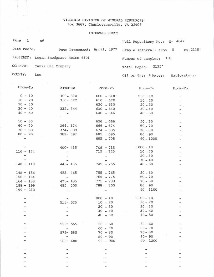
Page 1 of
Date rec1d:
VIRGINIA DIVISlml OF MINE&\L RESOURCES Box 3667, Charlottesville, VA 22903
INTERVAL SHEBT
~'1ell Reposi -tory No.: w- 4647
['ate Processed: April, 1977 Sample Interval: frora 0 to: 2135 1
PR(j~ERTY: Logan Snodgrass Heirs #101 Number of samples: 181
COHPANY: Tamik Oil Company
C0V:J'ry : Lee
From-l'o
o - 10 10 - 20 20 - 30 30 - 40 40 - 50
50 - 60 60 - 70 70 - 80 80 - 90
116- 124
140 - 148
148 - 156 156 - 164 164 - 188 188 - 199 199 - 210
From-To
300- 310 310_ 322
332_ 344
364- 374 374- 389 389- 397
400- 415
445- 455
455- 465
475- 485 485- 500
515- 525
555- 565
575- 585
585- 600
Total Depth: 2135 1
')il or Gas: X Water: Exploratory:
From-Tv Frorrl-To From-To
600 - 610 - 900 _ 10 610 - 620 10 - 20 620 _ 630 20 _ 30 630 _ 640 30 _ 40 640 _ 646 40 _ 50
656 _ 666 50 _ 60 666 _ 674 60 _ 70
674 - 685 70 - 80 685 - 695 80 _ 90 695 - 708 90 - 1000
708 - 715 1000 - 10 715 - 725 10 - 20
20 - 30 30 - 40
745 - 755 40 - 50
755 - 765 50 - 60 765 - 775 60 - 70 775 - 788 70 - 80 788 - 800 80- 90
90 - llOO
800 - 10 1100 .. 10 10 - 20 10- 20 20 - 30 20 - 30 30 - 40 30 - 40 40 - 50 40_ 50
50 60 50- 60 60 70 60- 70 70 - 80 70- 80 80 - 90 80- 90 90 - 900 90 - 1200

VIRGINIA DIVISION OF MINERAL RESOURCES Box 3667, Charlottesville, VA 22903
INTERVAL SHEET Continued
Page 2 of Well Repository No. : w- 4647
From-To From-To From-To From-To From-To
1200 - 10 1600 - 10 2000 - 10 10 - 20 10 - 20 10 - 20 20 - 30 20 - 20 20 - 29 30 - 40 30 - 40 29 - 34 40 - 50 40 - 50 34 - 45
50 - 60 50 - 60 45 - 51 60 - 70 60 - 7'0 51 - 61 70 - 80 70 - 80 72 - 83 80 - 90 80 - 90 83 - 89 90 - 1300 90 - 1700 89 - 94
94 - 2100 1300 - 10 1700 - 10 2100 - 2105
10 - 20 1715 - 1722 2119 - 2135 20 - 30 1722 - 1730 30 - 40 1736 - 1744 40 - 50 1744 - 1755
SO - 60 1755 - 65 60 - 70 65 - 74 70 - 80 74 - 85 80 - 90 85 - 96 90 - 1400 96 - 1800
1400 - 10 1800 - 1806 10 - 20 06 - 14 20 - 30 14 - 30 30 - 40 30 - 36 40 - 50 36 - 43
50 - 60 43 - 53 60 - 70 53 - 63 70 - 80 63 - 71 80 - 90 71- 81 90 - 1500 81 92
1892 1900 1500 - 10 1900 08
10 - 20 08 15 20 - 30 15 21
21 26 26 33
50 60 33 44 60 70 51 60 70 80 61 67 80 90 67 77 90 - 1600 77 88
88 2000


