
Social Studies World Geography Unit 06: Europe 20122013
This document is the property of TESCCC/CSCOPE and as such may not be replicated or changed without permission.

1 The Ruhr is a region of western Germany
with rich soil and mineral deposits. Farming
has been the traditional use of the land.
Beginning in the 1800s, coal companies
moved in and increasingly exploited the
mineral deposits. Today, there are over
300 coal mines in the region.
What change in European society has
caused this shift in the use of the land in
the Ruhr?
A People no longer needed farm products.
B Erosion in the region led many farmers
to move to more fertile lands.
C Commercial farming made farmlands in
the region less important.
D Industrialization led to the need to use
the coal resources of the region.
2 How has Eastern Europe been
most affected by the use of a variety of
languages?
F It has led to new arts and literature.
G It has made unification difficult.
H It has improved trade and commerce.
J It has allowed the English language to
become dominant.
3 Which pull factor has led many immigrants
to European nations in recent decades?
A to gain economic opportunities
B to escape civil war
C to leave oppressive governments
D to avoid natural disasters
4 The French government imposes a quota
on the importation of foreign movies. For
every seven foreign movies shown, a
theater in France must show one
domesticallyproduced movie. Which
reason is the likely motivation for limiting
foreign movies in France?
F to prevent a loss of French culture
G to improve exports of French films
H to protect theater profits
J to monitor the messages of foreign films
5 Which factor has most contributed to the
reorganization of European national
boundaries since 1990?
A religion
B ethnicity
C political parties
D economies
6 federalism : United States of America ::
___________ : ___________
F European Union : economic policy
G socialism : communism
H supranationalism : European Union
J economic treaties : common good
GO ONPage 2This document is the property of TESCCC/CSCOPE and as such may not be replicated or changed without permission.

7 Which of the following most influences the
marine west coast climate of Europe?
A prevailing westerly winds off the
Atlantic Ocean
B the Alps
C prevailing southerly winds off the
Mediterranean Sea
D deforestation
8 Areas of Europe affected by a
Mediterranean climate most likely
experience —
F warm, dry summers
G short growing seasons
H cold, snowy winters
J heavy rains
Use the map and your knowledge of social studies to answer the following two questions.
GO ONPage 3This document is the property of TESCCC/CSCOPE and as such may not be replicated or changed without permission.

9 Which country most likely has the highest
standard of living?
A Poland
B France
C United Kingdom
D Bulgaria
10 Where are the leastdeveloped countries
located in Europe?
F north
G south
H east
J west
11 Which example BEST demonstrates a
European nation's use of technology
having lasting social, environmental, and
economic impacts?
A the use of polders in the Netherlands
to reclaim land from the sea
B the application of artificial fertilizers in
Ireland to improve potato crops
C the use of terracing in Switzerland to
provide additional farmland
D the partitioning of Germany after
World War II
Use the table and your knowledge of social studies to answer the following two questions.
Standard of Living Indicators for Selected Nations in Europe, 2011
Country Average Life
Expectancy
(in years)
Infant Mortality
(per 1,000
births)
Albania 77.4 22.8
Bulgaria 73.1 12.9
France 81.1 4.1
Germany 80.0 4.2
Hungary 74.8 7.5
Poland 76.3 7.8
Romania 72.5 17.2
United Kingdom 80.0 5.4
Source: the United Nations and the CIA Factbook
GO ONPage 4This document is the property of TESCCC/CSCOPE and as such may not be replicated or changed without permission.
13 Use the passage and your knowledge
of social studies to answer the
following question.
Six currentday countries were once part
of the nation of Yugoslavia: Bosnia
Herzegovina, Croatia, Macedonia,
Montenegro, Serbia, and Slovenia. The
Kingdom of Yugoslavia (1918–1941) was
formed as the "Kingdom of Serbs, Croats
and Slovenes" after World War I. These
ethnic groups had inhabited the area
since the 1600s. It was conquered in
1941 by the Axis powers. The Socialist
Federal Republic of Yugoslavia (1943–
1991) was a socialist successor state to
the kingdom. Starting in 1991, the SFRY
disintegrated into wars, which were
followed by the secession of most of the
republic's former ethnic states.
The human process that had the greatest
influence on the partitioning of the
Republic of Yugoslavia was the desire to
—
A maintain cultural identity
B migrate to other areas of Europe
C have the same form of government as
in Yugoslavia
D have far more influence as a nation
than Yugoslavia had
14 Use the passage and your knowledge
of social studies to answer the
following question.
Spain built Europe's first __________
plant nearly 40 years ago and is the
largest user of this technology in the
Western world. Spanish companies lead
the market, operating in regions including
India, the Middle East, and North America.
Spanish innovation contributes to bringing
sustainable ________ to millions.
Which terms complete the paragraph
above about technological innovation in
Europe?
F oil refining…energy
G desalination…clean water
H desalination…energy
J nuclear…transportation
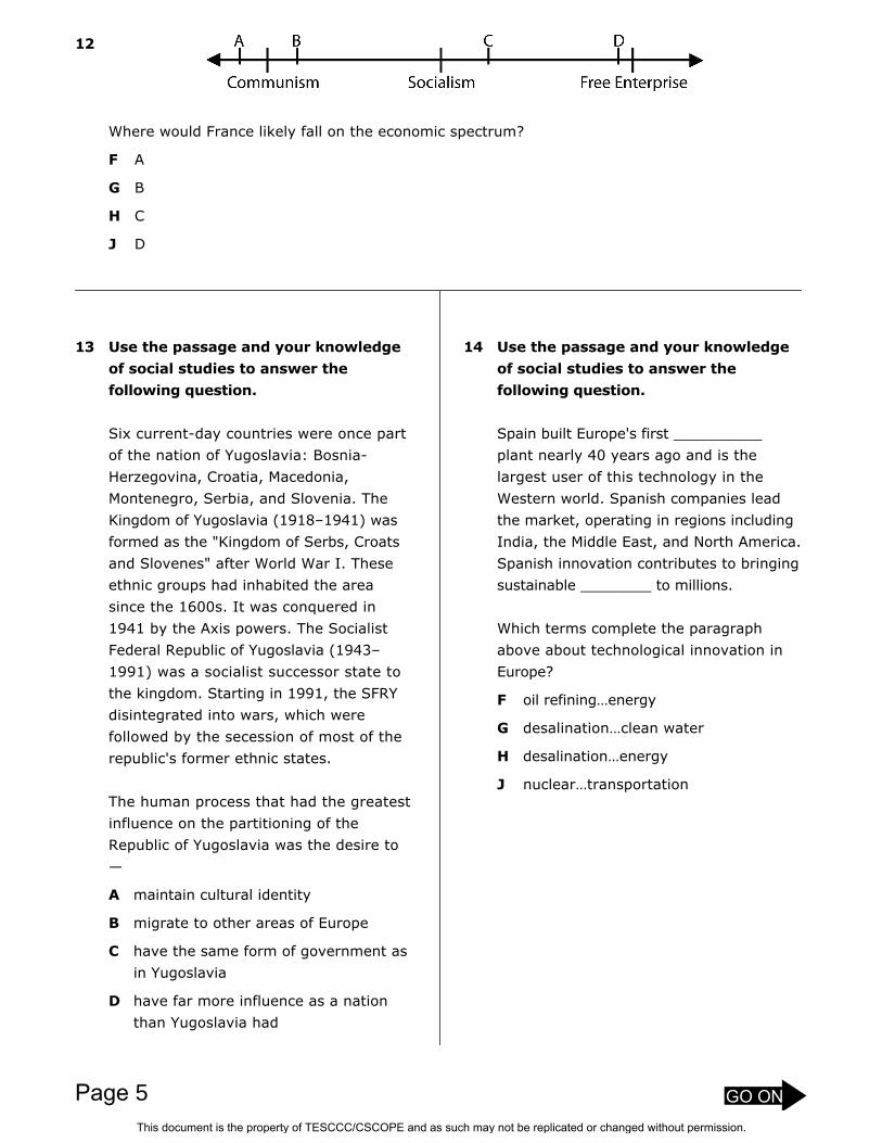
12
Where would France likely fall on the economic spectrum?
F A
G B
H C
J D
GO ONPage 5This document is the property of TESCCC/CSCOPE and as such may not be replicated or changed without permission.

Use the map and your knowledge of social studies to answer the following question.
GO ONPage 6This document is the property of TESCCC/CSCOPE and as such may not be replicated or changed without permission.

15 Which conclusion regarding the influence
of Catholicism on Europe is best
supported by evidence in the map?
A Islam has gained followers in Northern
Europe.
B Much of Europe is either predominately
Catholic or a related Christian religion.
C Catholicism across Europe serves as a
unifying influence among European
nations.
D The central location of Rome has led
to Catholicism dominating the
countries that border the
Mediterranean Sea.
16 Based on current immigration trends,
which religion is most likely to increase in
Western Europe over the next twenty
years?
F Catholic
G Protestant
H Orthodox
J Islam
17 How is the Catholic religion in Europe
related to cultural diffusion?
A The power and reach of the Ottoman
Empire brought Catholicism to the
region.
B The power and reach of the Roman
Empire brought Christianity to much of
the region.
C The Catholic religion of Ireland was
spread by the Vikings and other
invaders onto mainland Europe.
D The Protestant religion replaced the
Catholic religion through the spread of
the written word with the invention of
the printing press.
GO ONPage 7This document is the property of TESCCC/CSCOPE and as such may not be replicated or changed without permission.

Use the excerpts and your knowledge of social studies to answer the following questions.
(Associated Press: 2008) – A car bombing blamed on the armed Basque group ETA
killed an army officer and wounded 6 people in northern Spain this morning. It was the
third such attack in 24 hours in what appeared to be a steppedup ETA offensive. The
explosion happened as the building was being evacuated following a phone call from ETA
warning of the blast.
The bomb went off shortly after 1:00 a.m. outside an army academy in the northern
town of Santoña, following two other explosions in Basque towns yesterday. The attacks
may be linked to a recent court ruling to ban two proindependence Basque political
parties for having ETA links. Since 1968 the Basque separatist group has killed more than
825 people in Spain and France.
(Time Magazine: 2009) It was supposed to be a thing of the past. But as Northern
Ireland awoke Sunday morning to news of its worst atrocity in over a decade, terrorism, it
seemed, had made an unwelcome return to life in the province. The shooting at the
Massereene army base in Antrim, north of Belfast, killed two young soldiers and seriously
injured four others, including two civilians. Police say the soldiers came under attack when
they stepped out to collect a pizza delivery. And by all accounts, the gunmen were intent
on nothing less than murder. After they fired their initial shots, they approached the
soldiers, some of whom were lying on the ground, and shot them a second time. The 'Real
IRA' is believed to have carried out the attack. The group is one of a number of socalled
dissident republicans — hardliners who oppose the powersharing government between
Northern Ireland's Protestant and Catholic political parties. The 'Real IRA' was also
responsible for the Omagh bomb which claimed 29 lives in 1998 — the bloodiest atrocity in
Northern Ireland's 30year sectarian conflict.
18 Which cause is one reason that led to the terrorist act in Spain?
F religious differences
G desire for political separation and independence
H a pacifist movement against the military
J desire to extend power over other territories and groups
19 Why would these incidents be perceived as terrorism?
A The attacks were unexpected and often involved civilians.
B The attacks prompted a swift military response from the government.
C Government buildings were the target in order to destabilize the national government.
D Key industries were the target of the attacks in order to inflict damage to the economy.
GO ONPage 8This document is the property of TESCCC/CSCOPE and as such may not be replicated or changed without permission.

Use the map, table, and passage to answer the following two questions.
GO ONPage 9This document is the property of TESCCC/CSCOPE and as such may not be replicated or changed without permission.

Population in Millions
Austria 8.3 Latvia 2.3
Belgium 10.5 Lithuania 3.4
Bulgaria 7.7 Luxembourg .5
Cyprus .8 Malta .4
Czech Republic 10.3 Netherlands 16.3
Denmark 5.4 Poland 38.1
Estonia 1.3 Portugal 10.6
Finland 5.3 Romania 21.6
France 60.9 Slovakia 5.4
Germany 82.5 Slovenia 2
Greece 11.1 Spain 43.8
Hungary 10.1 Sweden 9
Ireland 42.2 United Kingdom 60.4
Italy 58.8
The Council of the European Union
The Council consists of ministers from each of the member countries in the European Union (EU).
Different ministers attend, representing different issues – (such as the French foreign ministers will
attend some meetings while the French ministers for agriculture will attend others).
Each country has a number of votes based mostly on the size of the population, but there is a
weighting formula that favors smaller countries, giving them more voice than they otherwise would
have. Most decisions are taken by majority vote.
The Council consists of ministers from the national governments of all the EU countries. Meetings
are attended by whichever ministers are responsible for the items to be discussed: foreign
ministers, ministers of the economy and finance, ministers for agriculture and so on, as
appropriate.
Up to four times a year the presidents and/or prime ministers of the Member States meet as the
European Council. These "summit" meetings set overall EU policy.
GO ONPage 10This document is the property of TESCCC/CSCOPE and as such may not be replicated or changed without permission.

20 Which list of countries benefits from the voting rules that govern the European Union?
F Cyprus, Luxembourg, Malta
G Germany, Italy, United Kingdom
H France, Spain, Italy
J Estonia, Poland, Germany
21 Which statement accurately represents the relationship of land area in Europe to size of
population?
A Germany has a greater population density than Spain.
B Smaller countries are found adjacent to major waterways such as seas and oceans.
C Finland has a denser population than France.
D Political boundaries of countries are apparently along physical geographic boundaries.
GO ONPage 11This document is the property of TESCCC/CSCOPE and as such may not be replicated or changed without permission.

Use the map and your knowledge of social studies to answer the following questions.
GO ONPage 12This document is the property of TESCCC/CSCOPE and as such may not be replicated or changed without permission.

22 In countries along the Atlantic Ocean,
more people have demand for high speed
transportation in which of these
locations?
F between Madrid and Barcelona and in
and out of Paris
G between London and Paris
H in and out of capital cities
J between Paris and London and along
the Atlantic coast of France
23 Which of the following has provided a
demand for highspeed rail technology?
A tourism to Europe from other parts of
the world
B the European Union creating
connections across political lines for
work and trade
C a need for day travel so that business
can be conducted without overnight
stays
D all of these.
GO ONPage 13This document is the property of TESCCC/CSCOPE and as such may not be replicated or changed without permission.

24 At which level of economic activity are
most European countries (according to
the map)?
F primary
G secondary
H tertiary
J quaternary
25 Which countries most likely have a
combination of a primary and secondary
economy?
A Albania and Romania
B Germany and France
C Portugal and Poland
D Serbia and Slovakia
Use the map and passage with your knowledge of social studies to answer the following
questions.
The percentage of the population involved in specific activities determines the level of economic
development of a nation. Those economic activities are designated as primary, secondary,
tertiary, and quaternary. In a primary economy, much of the population is dependent on use of
the land, like farming, mining, fishing, and hunting. In a secondary economy, much of the
population is involved in manufacturing. This includes taking any products of the land and creating
another product, like grinding grain into flour. A tertiary economy has a large percentage of its
population in the services sector. This includes sales, maintenance, and repair work. Finally,
quaternary societies have citizens working at computers with information processing and
conducting scientific research.
Adapted from Human Geography, R.E. Nelson, et. al.
GO ONPage 14This document is the property of TESCCC/CSCOPE and as such may not be replicated or changed without permission.

GO ONPage 15This document is the property of TESCCC/CSCOPE and as such may not be replicated or changed without permission.

26 Use the political and physical maps of Europe on the previous page.
Identify three natural borders that have been used to define political units.
_______________________________________________________________________________
_______________________________________________________________________________
_______________________________________________________________________________
_______________________________________________________________________________
_______________________________________________________________________________
_______________________________________________________________________________
_______________________________________________________________________________
_______________________________________________________________________________
_______________________________________________________________________________
_______________________________________________________________________________
_______________________________________________________________________________
_______________________________________________________________________________
STOPPage 16This document is the property of TESCCC/CSCOPE and as such may not be replicated or changed without permission.

## Item # Correct AnswerPrimarySE
SecondarySE
Obj/Cat
1 S0WG18997CS DWGS.2(B)[S]
NoneSTAAR: WorldGeography 1
2 S0WG19000CS GWGS.5(A)[R]
NoneSTAAR: WorldGeography 2
3 S0WG19005CS AWGS.7(B)[R]
NoneSTAAR: WorldGeography 2
4 S0WG19009CS FWGS.7(D)[S]
NoneSTAAR: WorldGeography 2
5 SWG1070835RX B WGS.14(A) None None
6 S0WG019664CS HWGS.7(D)[S]
NoneSTAAR: WorldGeography 2
7 S0WG18999CS AWGS.4(A)[R]
WGS.21(C)[P]
STAAR: WorldGeography 2
8 SWG1088908D FWGS.4(A)[R]
WGS.21(C)[P]
STAAR: WorldGeography 2
9 SWG1088910D BWGS.5(B)[S]
NoneSTAAR: WorldGeography 2
10 S0WG017501cs HWGS.5(B)[S]
WGS.21(B)[P]
STAAR: WorldGeography 2
11 S0WG19017CS AWGS.20(B)[S]
NoneSTAAR: WorldGeography 4
12 S0WG19010CS HWGS.10(B)[S]
NoneSTAAR: WorldGeography 4
13 SWG1089984D AWGS.18(B)[S]
WGS.21(A)[P]
STAAR: WorldGeography 3
14 S0WG019661CS GWGS.19(B)[S]
NoneSTAAR: WorldGeography 4
15 S0WG019690CS BWGS.17(A)[R]
WGS.21(C)[P]
STAAR: WorldGeography 3
16 S0WG019660CS JWGS.17(A)[R]
NoneSTAAR: WorldGeography 3
17 SWG19682CS BWGS.17(A)[R]
NoneSTAAR: WorldGeography 3
18 S0WG019643CS GWGS.18(B)[S]
WGS.22(B)STAAR: WorldGeography 3
19 S0WG019685CS AWGS.18(B)[S]
WGS.21(A)[P]
STAAR: WorldGeography 3
20 S0WG019691CS FWGS.13(B)[S]
NoneSTAAR: WorldGeography 1
21 SWG1089988D AWGS.13(A)[P]
WGS.21(C)[P]
None
Test Key
Social Studies World Geography Unit 06: Europe 2012-2013
This document is the property of TESCCC/CSCOPE and as such may not be replicated or changed without permission.

22 S0WG019663CS HWGS.19(A)[R]
WGS.21(C)[P]
STAAR: WorldGeography 4
23 S0WG019662CS DWGS.19(A)[R]
NoneSTAAR: WorldGeography 4
24 S0WG017552cs JWGS.11(A)[S]
WGS.21(C)[P]
STAAR: WorldGeography 4
25 SWG19678CS AWGS.11(A)[S]
WGS.21(C)[P]
STAAR: WorldGeography 4
26 S0WG019657CS
Answers will vary but include: Pyrenees Mountains betweenFrance and Spain, English Channel between England andFrance, Irish Sea between Ireland and England, Rhine Riverbetween France and Germany, Baltic Sea between Polandand Sweden, and others.
WGS.13(A)[P]
WGS.22(D) None
This document is the property of TESCCC/CSCOPE and as such may not be replicated or changed without permission.
![6DPSOHLQIRUPDWLRQ (XURSHDPRQJ(XURSH 6DPSOHVL]H …](https://cdn.vdocuments.us/doc/165x107/616a3d7511a7b741a350565f/6dpsohlqirupdwlrq-xurshdprqjxursh-6dpsohvlh-.jpg)


