5.2 Recommended projects The gaps suggested in this report are suggested as the basis for further discussions and generation of project proposals.
A stratigraphic well through basalt
It is recommended to perform a feasibility study and evaluation of the possible benefits of a stratigraphic well through the basalt area in the Vøring and /or Møre Basin to gather data, promote research and stimulate exploration activity. The western offshore areas of Mid-Norway are covered by basalt rocks. The physical nature of these rocks means that it is almost impossible produce seismic images of the sediments that lie beneath them. This has blocked oil exploration drilling in these basalt areas as there has so far been no possibility to identify oil bearing strata. However, it seems likely that a similar oil province to Haltenbanken could lie beneath these basalts. The (se) research well(s) could be used as natural laboratories being studied by academia and industry in a joined effort. Close cooperation between institutes would provide a stimulating environment for advanced research within G&G fields lacking muscle, e.g. stratigraphy. A wealth of information pertaining to rock physics, sedimentology, heat flow etc could be gathered.

NPD’s play models
Basalt areas
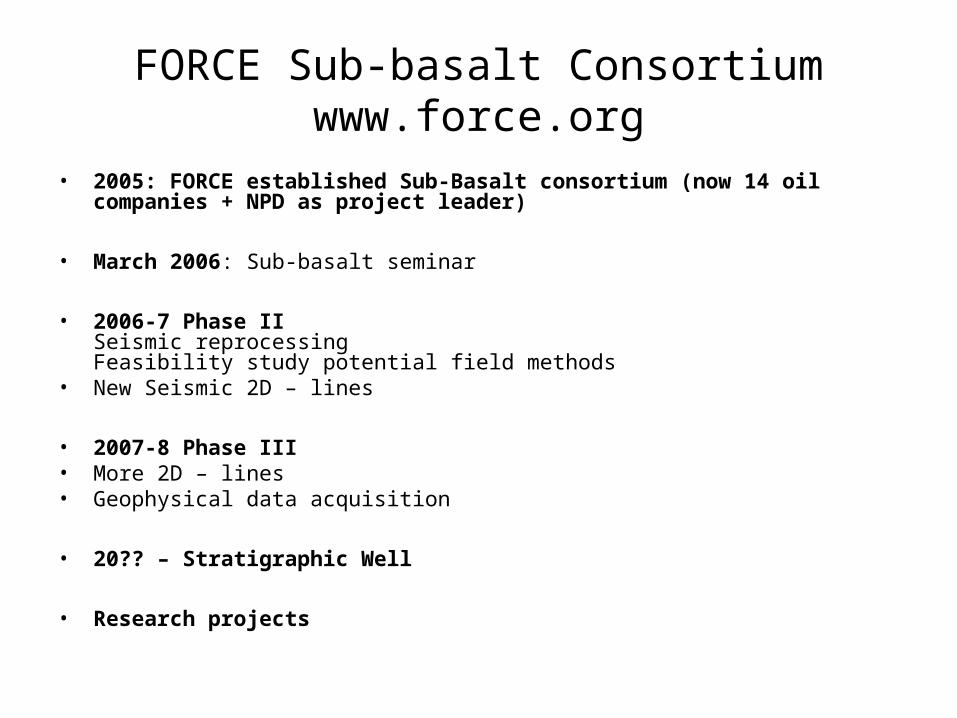
FORCE Sub-basalt Consortiumwww.force.org
• 2005: FORCE established Sub-Basalt consortium (now 14 oil companies + NPD as project leader)
• March 2006: Sub-basalt seminar
• 2006-7 Phase II Seismic reprocessing Feasibility study potential field methods
• New Seismic 2D – lines
• 2007-8 Phase III• More 2D – lines• Geophysical data acquisition
• 20?? – Stratigraphic Well
• Research projects

New Span line
MB-11-92
MB-09-92
6330-92
6730-92
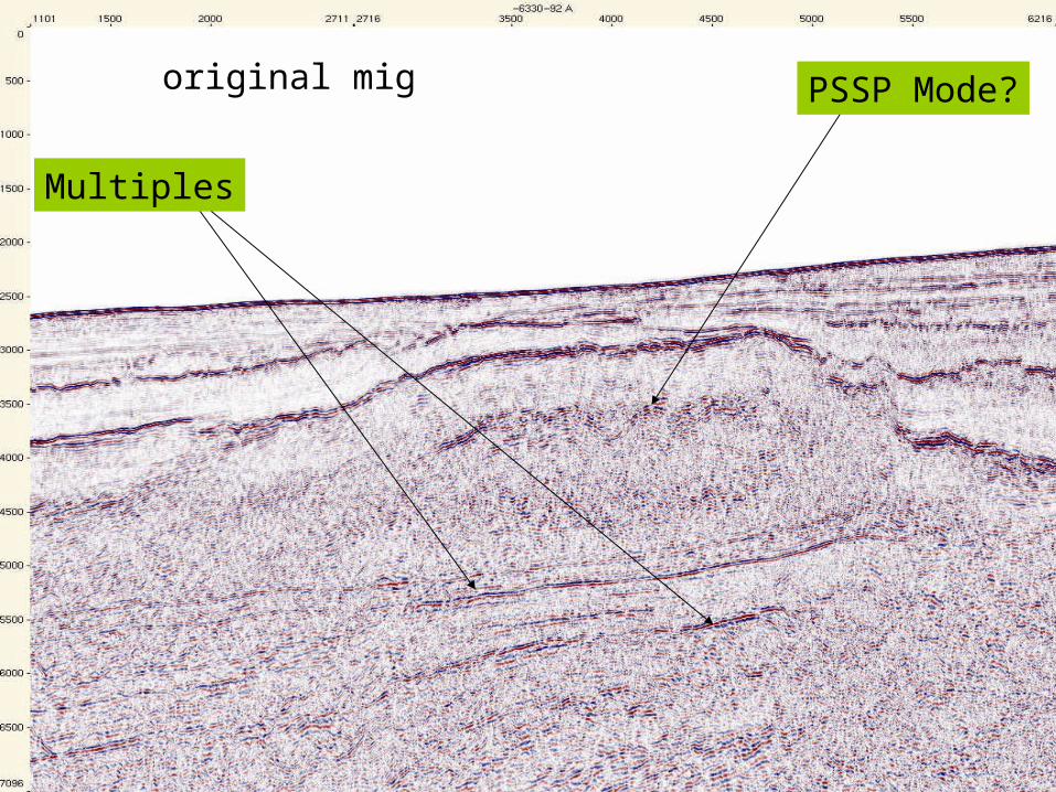
Multiples
PSSP Mode?original mig
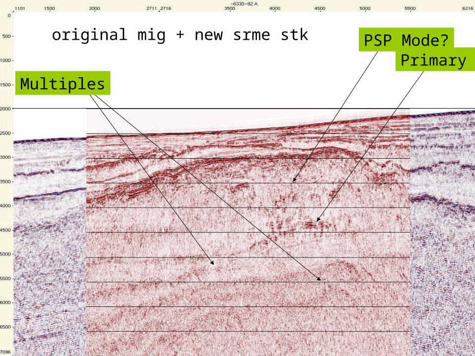
Multiples
Primary APSP Mode?original mig + new srme stk

NGU/EMGSFeasibility study of integrated electromagnetic, gravimetric,
aeromagnetic and seismic sub-basalt exploration techniques
Objectives
• Construct a model of sub-basalt structures on the Møre Margin from potential field, seismic and well log data
• Attribute electric resistivity data to the model
• Simulate the electromagnetic response for the given geometry over the most likely 3D geo-model.
• Assess the feasibility of EM methods (Sea Bed Logging [SBL] and Marine Magneto-Tellurics [MMT]) for the sub-basalt imaging.
• Select optimal frequencies and transmitter waveform for a following acquisition if the metod is applicable.

Outline of model for feasibility study

ION (GXT) NE Atlantic Span Line layout
209HYDRO
209HYDRO
281
388209
322
251 320SHELL
322
387
388
BG GROUP
251 208DONG
281STATOIL
387
388 251 250SHELL
387
251
322STATOIL
253 281STATOIL
253
62 30 62 30
62 45 62 45
63 00 63 00
63 15 63 15
63 30 63 30
63 45 63 45
64 00 64 00
64 15 64 15
64 30 64 30
2
2
4
4
360000
360000
400000
400000
440000
440000
480000
480000
520000
520000
560000
560000
600000
600000
6920000 6920000
7000000 7000000
7040000 7040000
7080000 7080000
7120000 7120000
7160000 7160000
1
2
GRA
V-01-9
1
33
MB -0400-91
1
200
1080 MB -0400-91-A
1031
1200
2000
2589 MB -0400-91-B
2540 2600
3993 MB -0400-91-C
3944 4000
6000
MB-6410-91
1000
2 00 0
4 000
4 98 8
MB-6410-91-A
4947
5 0
00
5 621
MB-6425-91
1
2 00
1 534
MB-6425-91-A
1485 1600
1835
MB-6425-91-B
1787 1 800
2 000
4 000 4 091
MB-6425-91-C
4046 4200
5600
6240-92 31
17
3200
4000
4562
6240-92-A
4508
4 6
00
5 060
6240-92-B
5 006
5 200
6 000
6 318
6240-92-C
101 200
1365
6240-92-D
1311 1400
2000
3387
6250-92-A
1337 1 400
2 000 2 030
6250-92-B
3000
3 0
00
4 000
6 000
6 854
6250-92-C
200
1063
6315-92
183 8
2 000
3 963
6315-92-A
3893
40
00
4730
6315-92-B
5546
56
00
6000
8000
8260
6315-92-C
4676
48
00
5600
6315-92-D
1000
1828
6330-92
400
1068
6330-92-A
1014
1 20 0
2 000
4 000
4 499
6330-92-B
4436
4 600
6 000
7 338
6330-92-C
8272 8400
8600
6345-92
1610
1 800
2 000
4 000
5 410
6345-92-A
5356
54
00
6000
8000
6345-92-C
1800
2000
2579
11
1
1
1
1
1
1
1
0 20 40 60 Km


