download measuring the street
TRANSCRIPT
1
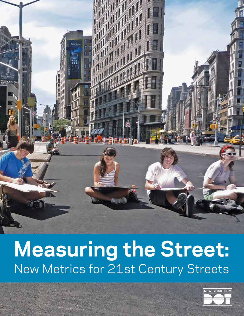
Measuring the Street:New Metrics for 21st Century Streets

Measuring the Street: New Metrics for 21st Century StreetsNew York City’s streets are constantly called on to the meet new and varied needs of a growing, dynamic, 21st Century city – and to do this in a complex environment where there is little opportunity to expand the existing footprint. How do city leaders address these challenges and measure their success? This report discusses key approaches to street design projects, and how results can be measured against goals for safety, serving all users and creating great public spaces while also maintaining the flow of traffic. Using a cross-section of recent NYCDOT street design projects, this report details the metrics NYCDOT uses to evaluate street projects, and illustrates how measuring results can show progress toward safe, sustainable, livable and economically competitive streets.
Design for safety
Design for all users of the street
Design great public spaces
Goals
Designing safer streets, to provide safe and attractive options for all street users ...............................Page 4
Building great public spaces to create economic value and neighborhood vitality ..............................Page 6
Improving bus service to bring rapid transit beyond the subway ..........................................................Page 8
Reducing delay and speeding to allow for faster, safer travel .............................................................................Page 10
Efficiency in parking and loading to improve access to businesses and ........................................Page 12 neighborhoods
Strategies
2

Cities need to set new goals for their streets if they are to meet the needs of a dynamic and growing city and address the problems of vehicle crashes, traffic congestion, poor-performing bus and bike networks, and environments that are inhospitable for pedestrians. New York has been able to transform our streets by blending new technologies with time-tested tools to create 21st Century Streets for all users.
The projects described in this report demonstrate this approach. The metrics shown here track the success of these projects, inform the design of future projects and are vital to building public support for world-class streets.
• Crashes and injuries for motorists, pedestrians, and cyclists
• Volume of vehicles, bus passengers, bicycle riders, and users of public space
• Traffic speed, aiming to move traffic not too slowly, but also not too fast
• Economic vitality, including growth in retail activity
• User satisfaction
• Environmental and public health benefits
Designing safer streets, to provide safe and attractive options for all street users ...............................Page 4
Building great public spaces to create economic value and neighborhood vitality ..............................Page 6
Improving bus service to bring rapid transit beyond the subway ..........................................................Page 8
Reducing delay and speeding to allow for faster, safer travel .............................................................................Page 10
Efficiency in parking and loading to improve access to businesses and ........................................Page 12 neighborhoods
Metrics
3

4
First protected bicycle lane in the US:8th and 9th Avenues (Manhattan)
Designing safer streets Safe and attractive options for all users
Mixing zones for bicycles and left-turning vehicles
Parking-protected bike lane Pedestrian safety
islands
Left turn bays and signal
phases35% decrease in injuries to all street users (8th Ave)
58% decrease in injuries to all street users (9th Ave)
Up to 49% increase in retail sales (Locally-based businesses on 9th Ave from 23rd to 31st Sts., compared to 3% borough-wide)
4
5
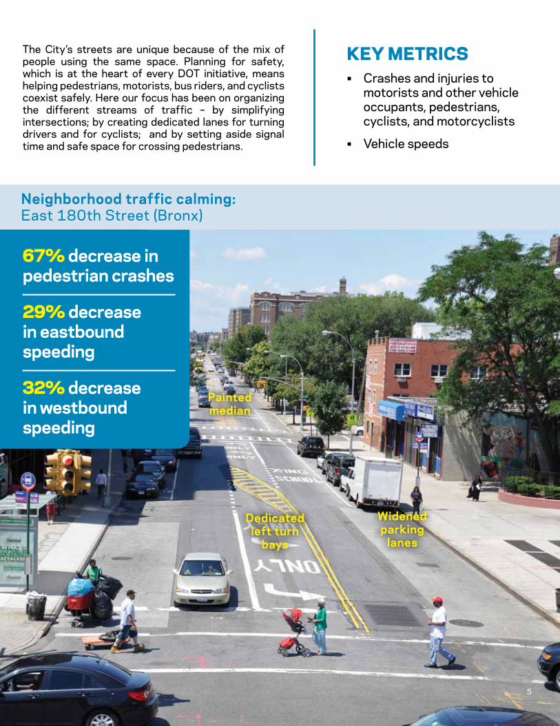
The City’s streets are unique because of the mix of people using the same space. Planning for safety, which is at the heart of every DOT initiative, means helping pedestrians, motorists, bus riders, and cyclists coexist safely. Here our focus has been on organizing the different streams of traffic – by simplifying intersections; by creating dedicated lanes for turning drivers and for cyclists; and by setting aside signal time and safe space for crossing pedestrians.
KEy mETRICs• Crashes and injuries to
motorists and other vehicle occupants, pedestrians, cyclists, and motorcyclists
• Vehicle speeds
Painted median
Neighborhood traffic calming:East 180th Street (Bronx)
Widened parking
lanes
Dedicated left turn
bays
67% decrease in pedestrian crashes
29% decrease in eastbound speeding
32% decrease in westbound speeding
5

6
Expanding an iconic space:Union Square North (Manhattan)
Building great public spaces Economic value and neighborhood vitality
Speeding decreased by 16%, while median speeds increased by 14%
Injury crashes fell by 26%
49% fewer commercial vacancies (compared to 5% more borough-wide)
74% of users prefer the new configuration
Pedestrian plaza
Simplified intersections
Protected bicycle path
6

7
Creating a seating area out of curb lane:Pearl Street (Manhattan)
New York’s streets serve more functions than simply moving people and goods. In such a densely populated city, the streets and sidewalks are places to congregate, relax, and enjoy being out in public.We have focused on creating great public spaces that serve individuals and groups large and small. Local organizations who maintain and program our public spaces help us ensure that these spaces will remain functional and useful for all users.
KEy mETRICs• Economic vitality (sales
tax receipts, commercial vacancies, number of visitors)
• User satisfaction, revealed through surveys
• Number of users
Transforming an underused parking area:Pearl Street (Brooklyn)
77% increase in seated pedestrians
14% increase in sales at fronting businesses
172% increase in retail sales (at locally-based businesses, compared to 18% borough-wide)
BID held 27 public events in 2012
Pedestrian plaza
Striping and planters
Maintenance partner agreement
Seasonal seating platform in
curbside lane 7

8
Making bus routes work better:Fordham Road (Bronx)
Improving bus service Rapid transit beyond the subway
20% increase in bus speeds
10% increase in bus ridership
71% increase in retail sales (at locally-based businesses, compared to 23% borough-wide)
Curbside red bus lanes
Delivery windows (curb dedicated to
trucks at key times)
Transit signal priority
8

9
Even though most New Yorkers use mass transit every day, the city’s buses are the slowest in North America. In partnership with MTA New York City Transit, DOT has introduced a new level of bus service, Select Bus Service (SBS), to some of the city’s busiest corridors. SBS includes off-board fare payment, three-door boarding to reduce boarding time; red bus lanes and Transit Signal Priority (TSP) to keep buses moving; and new shelters , buses, and bus bulbs to improve the passenger experience. SBS projects also include features to enhance pedestrian, cyclist, and traffic flow and safety.
KEy mETRICs• Bus ridership
• Bus travel speeds
• Economic vitality (sales tax receipts, commercial vacancies, number of visitors)
Dedicated lanes for both buses and bikes:First and Second Avenues (Manhattan)
9
18% increase in bus speeds
12% increase in bus ridership
Up to 177% increase in bicycle volumes
47% fewer commercial vacancies (compared to 2% more borough-wide)
37% decrease in injury crashes
Offset red bus lanes
Separated left turn lanes and dedicated
signal phases
Protected green
bike lanes
Pedestrian refuges
9

10
Creative traffic engineering for wide streets:Hoyt Avenue at the RFK Bridge (Queens)
Reducing delay and speeding Faster, safer travel
51% improvement in northbound travel times
21% decrease in crashes
37% increase in weekend bicycle volumes
Pedestrian refuges and crosswalks
Banned turns during peak
hours.
New signals and modified timings
Bicycle lanes
10

11
Streets that work for traffic have less congestion and more reliable travel times. Improving traffic flow need not come at the expense of safety, however. Organizing traffic, simplifying complicated intersections, and optimizing signals can reduce peak congestion, but also prevent speeding at other times. We have combined roadway markings, geometric changes, and signal timing to manage traffic safely – reducing congestion but also controlling excessive speeds.
KEy mETRICs• Travel speeds and times
• Traffic volumes
• Crashes and injuries to motorists and other vehicle occupants, pedestrians, cyclists, and motorcyclists
Using technology to manage a congested business district:42nd to 60th Street (Manhattan)
11
10% increase in travel speeds
9% decrease in Greenhouse Gas emissions in peak hours
Off-the-shelf technology (microwave traffic sensors, E-ZPass
readers) to measure congestion levels
New turn lanes
Engineers can adjust signal timings on the fly in response to real-time
traffic congestion.
Advanced traffic signals with remote
communications
11

12
Improving parking for local businesses:Park Slope (Brooklyn)
Efficiency in parking and loading Improving access to businesses and neighborhoods
20% decrease in average parking duration
18% more unique visitors found parking
7% reduction in traffic volumes (less cruising for parking)
Raised parking rates during peak demand periods
Installed muni meters areawide
12
13
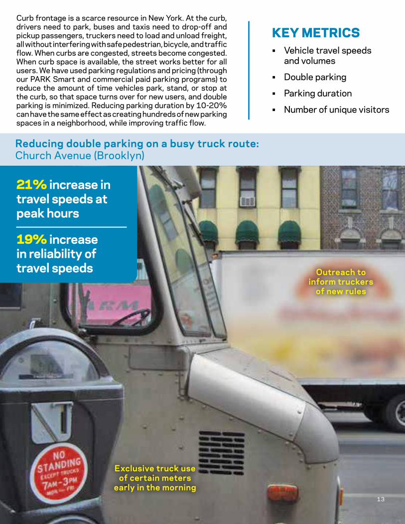
Curb frontage is a scarce resource in New York. At the curb, drivers need to park, buses and taxis need to drop-off and pickup passengers, truckers need to load and unload freight, all without interfering with safe pedestrian, bicycle, and traffic flow. When curbs are congested, streets become congested. When curb space is available, the street works better for all users. We have used parking regulations and pricing (through our PARK Smart and commercial paid parking programs) to reduce the amount of time vehicles park, stand, or stop at the curb, so that space turns over for new users, and double parking is minimized. Reducing parking duration by 10-20% can have the same effect as creating hundreds of new parking spaces in a neighborhood, while improving traffic flow.
KEy mETRICs• Vehicle travel speeds
and volumes
• Double parking
• Parking duration
• Number of unique visitors
Reducing double parking on a busy truck route:Church Avenue (Brooklyn)
13
Exclusive truck use of certain meters
early in the morning
Outreach to inform truckers
of new rules
21% increase in travel speeds at peak hours
19% increase in reliability of travel speeds
13

14
1. DEsIgnIng safER sTREETsKey treatments
Simplified intersectionsDedicated left, right, and through lanesPedestrian safety islandsProtected bike lanesLeading pedestrian intervals and split phasing
Also helpfulTurn bansMixing zones for bicycles and left-turning vehiclesMediansWide parking lanesSpeed humps and slow zones
2. BUIlDIng gREaT pUBlIC spaCEsKey treatments
Create new pedestrian plazas – first using temporary materials, later as capital projectsStreet furnitureSeasonal seating platform in curbside laneStriping and plantersMaintenance agreements with local organizationsProgrammed events
Also helpfulSimplified intersections
3. ImpRoVIng BUs sERVICEKey treatments
Offset bus lanesTransit Signal PriorityBus bulbsBus lane enforcement cameras
Also helpfulPedestrian safety islandsTurn lanes and turn bansDelivery windows
Street redesign inventory

15
4. REDUCIng DElay anD spEEDIngKey treatments
Adaptive signal controlSignal optimizationDedicated left, right, and through lanesSimplified intersectionsNeighborhood Slow Zones
Also helpfulProtected bicycle lanesPedestrian safety islandsWide parking lanes
5. EffICIEnCy In paRKIng anD loaDIng
Key treatmentsPARK SmartCommercial Paid ParkingDelivery WindowsMuni meters
Also helpfulOffset bus lanes
16