download-manuals-ground water-manual-gw-volume1designmanualhis
TRANSCRIPT
Government of India & Government of The Netherlands
DHV CONSULTANTS &DELFT HYDRAULICS withHALCROW, TAHAL, CES,ORG & JPS
VOLUME 1HYDROLOGICAL INFORMATION SYSTEM
DESIGN MANUAL
Design Manual – HIS (GW) Volume 1
Hydrological Information System March 2003 Page i
Table of Contents
1 INTRODUCTION 0
1.1 GENERAL 01.2 NATIONAL WATER POLICY OF INDIA 1
2 HYDROLOGICAL INFORMATION SYSTEM 3
2.1 DEFINITION OF HIS 32.2 ROLE OF HIS 32.3 SCOPE OF ACTIVITIES UNDER HIS 42.4 STRUCTURE OF HIS 62.5 STAFFING OF HIS 102.6 TIME SCHEDULE FOR DATA TRANSFER AND PROCESSING 13
3 DATA USERS AND DATA REQUIREMENTS 15
3.1 GENERAL 153.2 MANDATE OF HYDROLOGICAL SERVICE AGENCIES 153.3 ASSESSMENT OF DATA REQUIREMENTS 163.4 HYDROLOGICAL DATA USER GROUP 183.5 WORKING PLAN OF HDUGs 21
Design Manual – HIS (GW) Volume 1
Hydrological Information System March 2003 Page 0
1 INTRODUCTION
1.1 GENERAL
Water plays a crucial role in the socio-economic development of India. Safe drinking water is requiredfor the very large and growing population. Water has also become a major constraining factor for thegrowth of the agricultural and industrial sectors. In contrast, flooding frequently threatens populationsand their properties. Competing demands between users and states require proper planning, designand management of water resources and water use systems. The availability of an efficient andcomprehensive Hydrological Information System (HIS), comprising a reliable data base on all aspectsof the hydrological cycle, is a prerequisite for such planning, design and management, to get betterdecisions made as well as to achieve efficiency.
The prime objective of the Hydrology Project is to develop a sustainable Hydrological InformationSystem for 9 states in Peninsular India, set up by the state Groundwater and Surface WaterDepartments and by the central agencies (CGWB and CWC ) with the following characteristics:
• Demand driven, i.e. output is tuned to the user needs• Use of standardised equipment and adequate procedures for data collection and processing• Computerised, comprehensive and easily accessible database• Proper infrastructure to ensure sustainability.
This Hydrological Information System provides information on the spatial and temporal characteristicsof water quantity and quality variables/parameters describing the water resources/water use system inPeninsular India. The information needs to be tuned and regularly be re-tuned to the requirements ofthe decision/policy makers, designers and researchers to be able to take decisions for long termplanning, to design or to study the water resources system at large or its components.
This manual describes the procedures to be used to arrive at a sound operation of the HydrologicalInformation System as far as hydro-meteorological and surface water quantity and quality data areconcerned. A similar manual is available for geo-hydrological data.
Each part consists of Ten volumes, covering:
1. Hydrological Information System, its structure and data user needs assessment
2. Sampling Principles
3. Hydro-meteorology
4. Geo-Hydrology
5. GIS –Creation of datasets
6. Water Quality sampling
7. Water Quality analysis
8. Data processing, and Analysis
9. Data transfer, storage and dissemination.
10. GW-Protocols
Each volume comprises one or more of the following manuals, viz:
• Design Manual, (Volumes 1, 2, 3, 4 and 6)
• Field Manual, (Volumes 1, 3, 4 and 6)
• Reference Manual (Volumes 1 to 4 and 8), and
• Operation Manual (Volumes 7 to 10).
Design Manual – HIS (GW) Volume 1
Hydrological Information System March 2003 Page 1
The Design Manuals provide the procedures for the design activities to be carried out for theimplementation and further development of the HIS. The Field Manuals and Operation Manuals areinstruction books describing in detail the activities to be carried out in the field (station operation,maintenance and calibration), at the laboratory (analysis), and at the data processing centres (dataentry, validation, processing and analysis) and data storage centres (data transfer, storage anddissemination). A Field/Operation Manual is divided into a number of parts, each describing a certainactivity, to be used at a particular field station, laboratory or processing/storage centre. The ReferenceManual of a particular Volume includes additional or background information on topics dealt with ordeliberately omitted in the Design, Field and Operation Manuals.
1.2 NATIONAL WATER POLICY OF INDIA
Ultimately HIS is meant to contribute to the realisation of GOI’s policies and strategies in the watersector. The National Water Policy (MOWR, 2002) (see Volume 1, Reference Manual) specifies thebasic principles which should be followed in decision making and all activities in this sector, see Table7.3. Integrated and coordinated development of surface water and ground water resources and theirconjunctive use, should be envisaged right from the project planning stage and should form anintegral part of the project implementation.
More specifically related to the HIS, the National Water Policy stipulates in article 2:
2.1 A well developed information system, for water related data in its entirety, at the national / statelevel, is a prime requisite for resource planning. A standardised national information systemshould be established with a network of data banks and data bases, integrating and strengtheningthe existing Central and State level agencies and improving the quality of data and the processingcapabilities.
2.2 Standards for coding, classification, processing of data and methods / procedures for its collectionshould be adopted. Advances in information technology must be introduced to create a moderninformation system promoting free exchange of data among various agencies. Special effortsshould be made to develop and continuously upgrade technological capability to collect, processand disseminate reliable data in the desired time frame.
2.3 Apart from the data regarding water availability and actual water use, the system should alsoinclude comprehensive and reliable projections of future demands of water for diverse purposes.
Actually, the National Water Policy is essentially a guideline. There is a need to develop more definitecriteria for the management of this resource, such as the allocation of water amongst different users.Proper application of such criteria in any specific situation requires a sound understanding of theavailable water resources and their existing uses. This has to be supported by reliable hydrologicalanalysis for which, in turn, sufficient and accurate data is needed. HIS is set-up to provide this data.The National Water Policy recognises the need for more specific strategies by asking in Article 3.3 forthe development of an overall water resources development plan for a hydrological basin as a whole,in order that the best possible combinations of options can be made.
National sector and state policies and strategies
Water management is not an objective in itself, should contribute to the realisation of sector policiesand strategies. Most important sector policies are:
• Annual or Five Year Plan• Agricultural and Irrigation Policies• Drinking Water and Sanitation Policies• Hydropower• Environmental Protection, etc.
Design Manual – HIS (GW) Volume 1
Hydrological Information System March 2003 Page 2
In all cases reliable data on hydrological quantity and quality variables and parameters are requiredfor the analysis, design and implementation of strategies and policies, which are to be provided by theHydrological Information System.
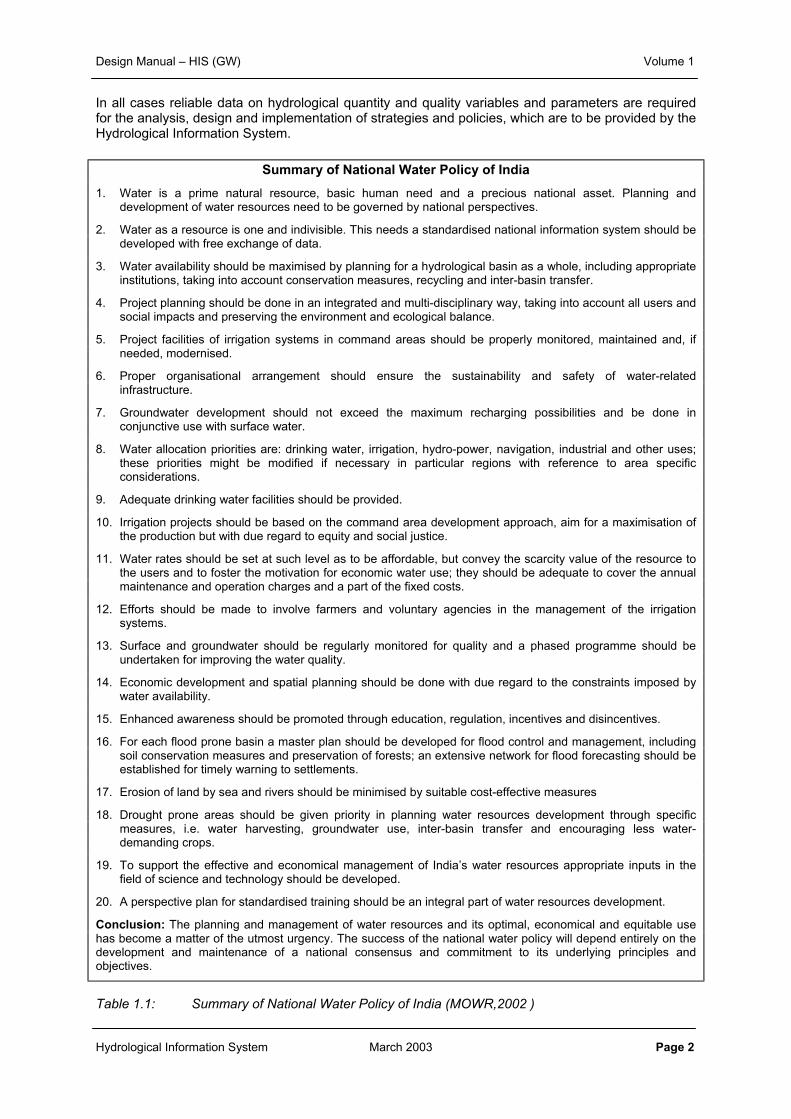
Summary of National Water Policy of India
1. Water is a prime natural resource, basic human need and a precious national asset. Planning anddevelopment of water resources need to be governed by national perspectives.
2. Water as a resource is one and indivisible. This needs a standardised national information system should bedeveloped with free exchange of data.
3. Water availability should be maximised by planning for a hydrological basin as a whole, including appropriateinstitutions, taking into account conservation measures, recycling and inter-basin transfer.
4. Project planning should be done in an integrated and multi-disciplinary way, taking into account all users andsocial impacts and preserving the environment and ecological balance.
5. Project facilities of irrigation systems in command areas should be properly monitored, maintained and, ifneeded, modernised.
6. Proper organisational arrangement should ensure the sustainability and safety of water-relatedinfrastructure.
7. Groundwater development should not exceed the maximum recharging possibilities and be done inconjunctive use with surface water.
8. Water allocation priorities are: drinking water, irrigation, hydro-power, navigation, industrial and other uses;these priorities might be modified if necessary in particular regions with reference to area specificconsiderations.
9. Adequate drinking water facilities should be provided.
10. Irrigation projects should be based on the command area development approach, aim for a maximisation ofthe production but with due regard to equity and social justice.
11. Water rates should be set at such level as to be affordable, but convey the scarcity value of the resource tothe users and to foster the motivation for economic water use; they should be adequate to cover the annualmaintenance and operation charges and a part of the fixed costs.
12. Efforts should be made to involve farmers and voluntary agencies in the management of the irrigationsystems.
13. Surface and groundwater should be regularly monitored for quality and a phased programme should beundertaken for improving the water quality.
14. Economic development and spatial planning should be done with due regard to the constraints imposed bywater availability.
15. Enhanced awareness should be promoted through education, regulation, incentives and disincentives.
16. For each flood prone basin a master plan should be developed for flood control and management, includingsoil conservation measures and preservation of forests; an extensive network for flood forecasting should beestablished for timely warning to settlements.
17. Erosion of land by sea and rivers should be minimised by suitable cost-effective measures
18. Drought prone areas should be given priority in planning water resources development through specificmeasures, i.e. water harvesting, groundwater use, inter-basin transfer and encouraging less water-demanding crops.
19. To support the effective and economical management of India’s water resources appropriate inputs in thefield of science and technology should be developed.
20. A perspective plan for standardised training should be an integral part of water resources development.
Conclusion: The planning and management of water resources and its optimal, economical and equitable usehas become a matter of the utmost urgency. The success of the national water policy will depend entirely on thedevelopment and maintenance of a national consensus and commitment to its underlying principles andobjectives.
Table 1.1: Summary of National Water Policy of India (MOWR,2002 )
Design Manual – HIS (GW) Volume 1
Hydrological Information System March 2003 Page 3
2 HYDROLOGICAL INFORMATION SYSTEM
2.1 DEFINITION OF HIS
In each state and for the central agencies Hydrological Information Systems have been developed. AHydrological Information System comprises the physical infrastructure and human resources tocollect, process, store and disseminate data on hydrological, geo-hydrological and hydro-meteorological variables. The physical infrastructure includes observation networks, laboratories, datacommunication systems and data storage and processing centres equipped with databases and toolsfor data entry, validation, analysis, retrieval and dissemination. The human resource refers to welltrained staff with a variety of skills to observe, validate, process, analyse and disseminate the data.Efficiency requires that all activities in the HIS are well tuned to each other, to provide the requireddata on time in proper form and at minimum cost.
In this chapter the scope of activities in the HIS, its structure and staffing is dealt with.
2.2 ROLE OF HIS
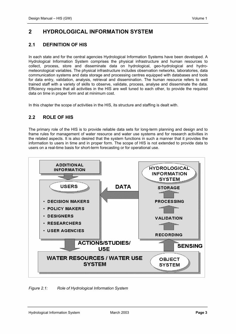
The primary role of the HIS is to provide reliable data sets for long-term planning and design and toframe rules for management of water resource and water use systems and for research activities inthe related aspects. It is also desired that the system functions in such a manner that it provides theinformation to users in time and in proper form. The scope of HIS is not extended to provide data tousers on a real-time basis for short-term forecasting or for operational use.
Figure 2.1: Role of Hydrological Information System
Design Manual – HIS (GW) Volume 1
Hydrological Information System March 2003 Page 4
To be able to provide this information the first step is to obtain the information on the temporal andspatial characteristics of this object system by having a network of observational stations. The basicdata collected for different hydro-meteorological phenomenon through this observational network iscalled the observed or field data. Such observed data have to be processed to ensure its reliability.Both field and processed data sets have to be properly stored, i.e. processed data for disseminationand field data to permit inspection and revalidation in response to queries from users.
2.3 SCOPE OF ACTIVITIES UNDER HIS
The activities under HIS can be broadly classified in the following categories:
• Assessing the needs of users• Establishment of an observational network• Management of historical data• Data collection• Data processing, analysis and reporting• Data exchange and reporting• Data storage and dissemination• Institutional and human resource development
Assessing the needs of users
To make full consideration of user needs a Hydrological Data User Group (HDUG) for each state andfor the central agencies has been constituted. Potential hydrological data users and the members ofHIS implementing agencies are represented in these HDUGs. The main aim of such HDUGs is toreview hydrological information needs and, on a regular basis of about 3-5 years, to identify shortfallsand to make suggestions and proposals for improvements. This will then require the implementingagency to reconsider its mandate and HIS objectives and incorporate improvements where possible.Improvements may also be needed to take care of equipment technology updates.
Establishment/review of observational networks
After the objectives of the system are laid down, the observational network has to be accordinglyplanned, designed and established/upgraded/adjusted. It is also important to ensure that theobservational networks of different agencies are properly integrated so that duplication is avoided.The equipment as per the revised objectives and design are installed at the observational stations.The process may be repeated after periodic reviews of requirements.
Management of historical data
State and central agencies have maintained observational networks for many years and voluminousrecords are held, the majority on manuscript or chart records, which are not readily accessible for useand are of variable quality. A program of historical data entry has been established in each agencyholding such data. Priority is given to ensuring that current data are entered validated and storedeffectively. The next priority is for historic data of the immediate past ten years and so on.
Data collection
Institutional, human and budgetary supports are a prerequisite for smooth operation and maintenanceof the observation stations and the associated collection of data. The established network has anumber of observation stations and at each station a number of variables is observed at a specifiedfrequency. The observations are taken manually or automatically depending upon the type ofinstrument available at the station. Suitable number of persons having skills appropriate to their jobrequirement (e.g., Supervisors, Technicians, Observers, Helpers etc.) are engaged and materials are
Design Manual – HIS (GW) Volume 1
Hydrological Information System March 2003 Page 5
provided at the observation sites for carrying out day-to-day data collection work and also for regularmaintenance.
Data processing, analysis and reporting
Data processing is a broad term covering all activities from receiving records of observed field data tomaking them available in a usable form. The field data are in a variety of formats such as hand-writtenrecords, charts and digital records. Data as observed and recorded may contain many gaps andinconsistencies. These observed data are passed through a series of operations, typically:
• Data entry• Making necessary validation checks,• Infilling missing values in a data series,• Processing of field data to estimate required variables,• Compilation of data in different forms and• Analysis of data for commonly required statistics etc.
Most of the data processing activities are to be accomplished with the help of computers usingdedicated hydrological data processing software. Of particular importance is assuring the quality andreliability of the data provided to users through the application of a variety of validation proceduresand the flagging of suspect data. The user must be informed of the quality of the data supplied andwhether the values are estimated or observed.
Reports are prepared to bring out the salient characteristics of the hydrological regime of the regionfor each year or season. Special reports are also made as and when required for attracting theattention of the users towards unusual events, major changes in the hydrological regime or todisseminate important revised long term statistics regularly.
Data exchange and communication
Data processing activities are carried out at more than one level within each agency and this makes itessential to have adequate data transport/communication links between them. The requirement forcommunication is to be based on a low frequency and high volume of communication. There is needfor exchange of information between various agencies for the purpose of data validation as surfaceand groundwater networks are operated by different state and central agencies.
Data storage and dissemination
All available data sets are maintained in well-defined computerised databases using an industry-standard database management system. This is essential for the long-term sustainability of the datasets in proper form and their dissemination to the end users. Both, field and processed data sets areproperly stored and archived to specified standards so that there is no loss of information. There isflexibility for data owners to decide user eligibility for data. Once eligibility is decided all agenciesapply standard procedures for the dissemination of data to the users from the computeriseddatabases.
The type of data stored in the database include:
• Geographical and space oriented data, i.e. static or semi-static data on catchment features andhydraulic infrastructure
• Location oriented data, including static or semi-static data of the observation stations andhydraulic structures
• Time oriented data, covering equidistant and non-equidistant time series for all types ofmeteorological, climatic, water quantity, quality and sediment data, and
Design Manual – HIS (GW) Volume 1
Hydrological Information System March 2003 Page 6
• Relation oriented data on two or more variables/parameters used with respect to meteorological,climatic, water quantity, quality and sediment data
Institutional and Human Resources development
Since HIS is a vast system, the aspect of institutional and human resource development needs to begiven proper emphasis. The institutions supporting the HIS must be developed in such a manner thatthe system is sustainable in the long run. The staff required to carry out different activities under HISare to be made available and very importantly they must all be trained to carry out the desired tasks.Such training support is to be ensured on a sustainable basis since there will always be a need fortraining more staff, to replace staff moving out due to retirements and rotational transfers.
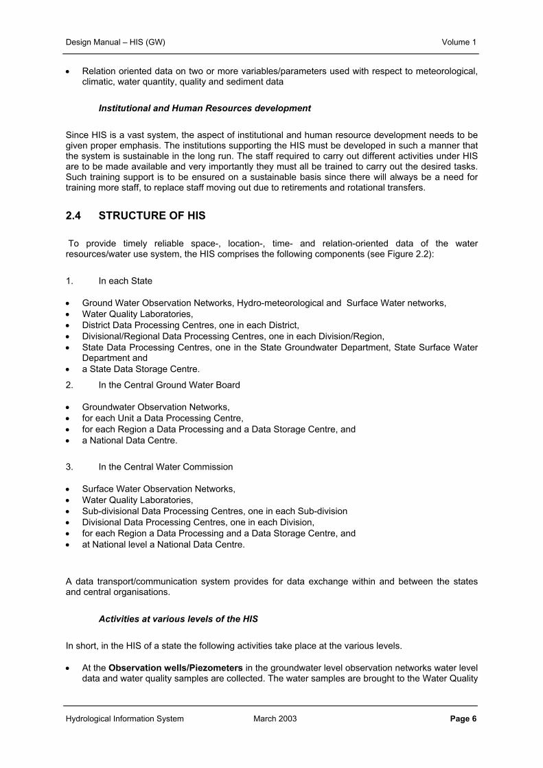
2.4 STRUCTURE OF HIS
To provide timely reliable space-, location-, time- and relation-oriented data of the waterresources/water use system, the HIS comprises the following components (see Figure 2.2):
1. In each State
• Ground Water Observation Networks, Hydro-meteorological and Surface Water networks,• Water Quality Laboratories,• District Data Processing Centres, one in each District,• Divisional/Regional Data Processing Centres, one in each Division/Region,• State Data Processing Centres, one in the State Groundwater Department, State Surface Water
Department and• a State Data Storage Centre.
2. In the Central Ground Water Board
• Groundwater Observation Networks,• for each Unit a Data Processing Centre,• for each Region a Data Processing and a Data Storage Centre, and• a National Data Centre.
3. In the Central Water Commission
• Surface Water Observation Networks,• Water Quality Laboratories,• Sub-divisional Data Processing Centres, one in each Sub-division• Divisional Data Processing Centres, one in each Division,• for each Region a Data Processing and a Data Storage Centre, and• at National level a National Data Centre.
A data transport/communication system provides for data exchange within and between the statesand central organisations.
Activities at various levels of the HIS
In short, in the HIS of a state the following activities take place at the various levels.
• At the Observation wells/Piezometers in the groundwater level observation networks water leveldata and water quality samples are collected. The water samples are brought to the Water Quality
Design Manual – HIS (GW) Volume 1
Hydrological Information System March 2003 Page 7
Laboratories. At regular intervals (monthly/quarterly) the field data are computerised –n theDistrict/Division/Regional Data Processing Centres.
• In the Water Quality Laboratories, beside the analysis of water quality samples, the analysisresults are entered in the computer and subjected to primary validation. At regular intervals, thelaboratory passes the information on to the nearest District/Divisional or Regional DataProcessing Centre.
• In the District Data Processing Centres all field data are entered or incorporated in thedatabase. Next, primary and secondary validation take place on the data. The Validated data arepassed on to the higher level Data Processing Centre immediately after carry out regionalvalidations .
Figure 2.2: HIS structure at State/Regional level
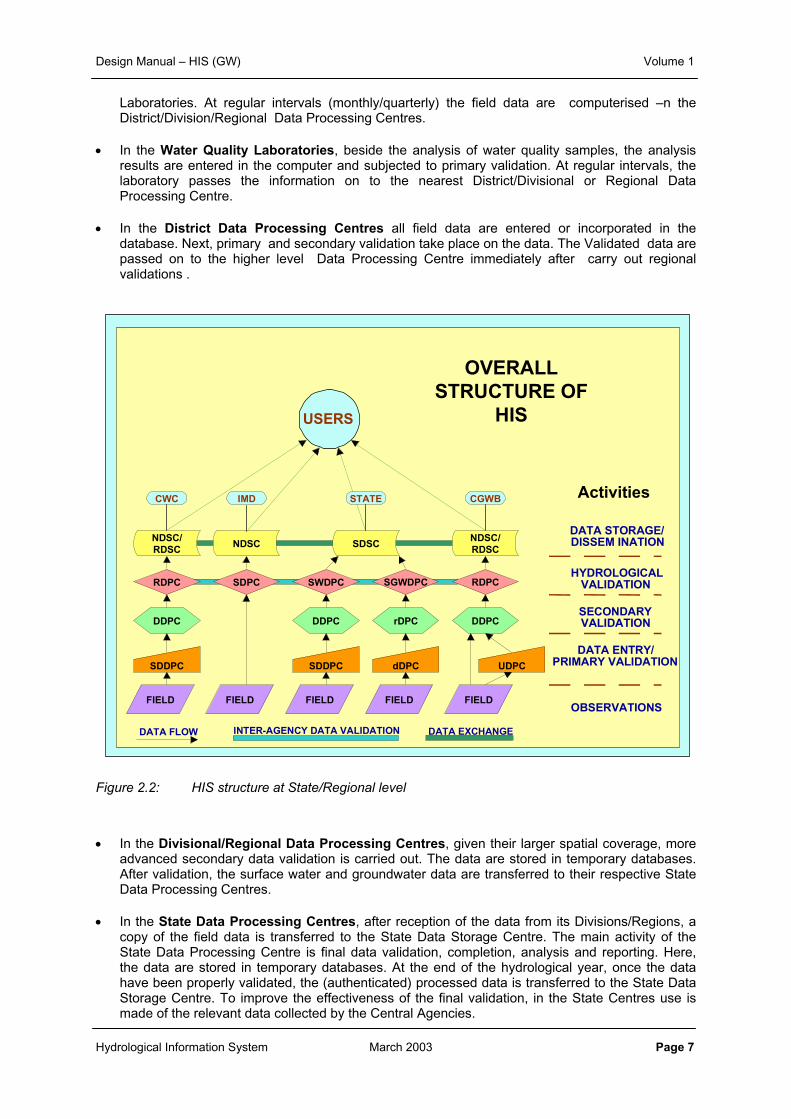
• In the Divisional/Regional Data Processing Centres, given their larger spatial coverage, moreadvanced secondary data validation is carried out. The data are stored in temporary databases.After validation, the surface water and groundwater data are transferred to their respective StateData Processing Centres.
• In the State Data Processing Centres, after reception of the data from its Divisions/Regions, acopy of the field data is transferred to the State Data Storage Centre. The main activity of theState Data Processing Centre is final data validation, completion, analysis and reporting. Here,the data are stored in temporary databases. At the end of the hydrological year, once the datahave been properly validated, the (authenticated) processed data is transferred to the State DataStorage Centre. To improve the effectiveness of the final validation, in the State Centres use ismade of the relevant data collected by the Central Agencies.
FIELD
DDPC
RDPC
USERS
FIELDFIELDFIELDFIELD
UDPCSDDPC
DDPCrDPCDDPC
RDPCSGWDPCSWDPCSDPC
SDSCNDSC/RDSC
NDSC/RDSC
NDSC
INTER-AGENCY DATA VALIDATION
OBSERVATIONS
DATA ENTRY/PRIMARY VALIDATION
SECONDARYVALIDATION
HYDROLOGICALVALIDATION
DATA STORAGE/DISSEM INATION
CWC CGWBSTATEIMD
DATA EXCHANGEDATA FLOW
SDDPC dDPC
Activities
OVERALLSTRUCTURE OF
HIS
Design Manual – HIS (GW) Volume 1
Hydrological Information System March 2003 Page 8
• The State Data Storage Centre stores and administers the storage of all field and(authenticated) processed hydrological data collected in the State, and makes the data availableto authorised Hydrological Data Users. As a State archive, it also maintains an HIS-Catalogue ofall data stored in its own database and those stored in the databases of the other states and ofthe Central Agencies.
The flow of data at the various levels in the HIS organisation is shown in Figure 2.3.
Figure 2.3: Data flow in HIS
Collection of SW / GW field data
Water sampling
Laboratorytesting
Analyses
Catalog
Field Datafrom Central
agencies
CGWBField Data
CWC &IMD
Field Data
Management Feedback
Temporary Database
Temporary Database
Temporary DPC Database
DSC database
Data Flow
HIS - Activities in data collection, processing, and storage
Transfer toState DPC
Transfer to Div/Regional DPC
Transfer to Subdiv/Dist DPC
Transfer toState DSC/DPC
Reporting
Transfer toState DSC
PrimaryValidation
SecondaryValidation
FinalValidation
Authenti-cated Data
Central Agen-cies’ field data
Temporary Database
PrimaryValidation
Field/Testdata
Fielddata
Fielddata
Testdata
ProcessedWQ data
Field/Testdata
Design Manual – HIS (GW) Volume 1
Hydrological Information System March 2003 Page 9
Separation of data processing and data storage functions
In HIS the data processing and the data storage functions are separated; data processing is done inthe Data Processing Centres, whereas the data archives are in the Data Storage Centres. Dataprocessing and validation is a technical task for which hydrologists/geo-hydrologists are qualified,whereas final data storage, i.e. the library function, is the domain of database managers. Thisdistinction is absolutely necessary for a number of reasons:
• Processing and storage are different disciplines, which require different expertise, tools, hardwaresupport, activities and responsibilities,
• To guarantee discipline in building the database and its sustainability on the long term,• To make sure that for design and decision making data are being used, which passed all steps of
validation,• To avoid mixing of fully processed data and the data under processing,• To register and control receipt and supply of authenticated data to and from the database in a
formalised manner,• To ensure compatible database configuration and protocols by all agencies,• To maintain a professional data security system under which each organisation maintains its
independence for user authorisation and data circulation, and• for an easier upgrading/replacement of either data storage or data processing tools in case of
new developments
Centralised versus distributed storage
Though the approach described above calls for separation of data processing and data storagefunctions, separate Data Storage Centres for Surface Water and Groundwater Departments are notadvocated. Combining the data storage activities in a State in one Data Storage Centre hasadvantages over separate centres, fully in line with the National Water Policy (MoWR, GoI, 2002).Advantages include:
1. A combined centre stimulates co-operation between all the Central and State Organisations whichimproves quality of the data,
2. It greatly benefits users by providing all information from a single place and thereby enhanced thewater resources assessment,
3. It improves the sustainability of the system and enhances the chances of a uniformsystem/approach on the long term, and
4. It reduces cost of hardware, software and of staff.
In case of a combined Data Storage Centre the manager can be appointed from the Surface Water orGroundwater side at the discretion of the competent authority. Where Surface Water andGroundwater Organisations are placed under different ministries a formal decision has to be takenunder which Ministry the Data Storage Centre has to be placed , with its inherent responsibilities forstaffing and maintenance, or whether each organisation should have its own Data Storage Centre.
Design Manual – HIS (GW) Volume 1
Hydrological Information System March 2003
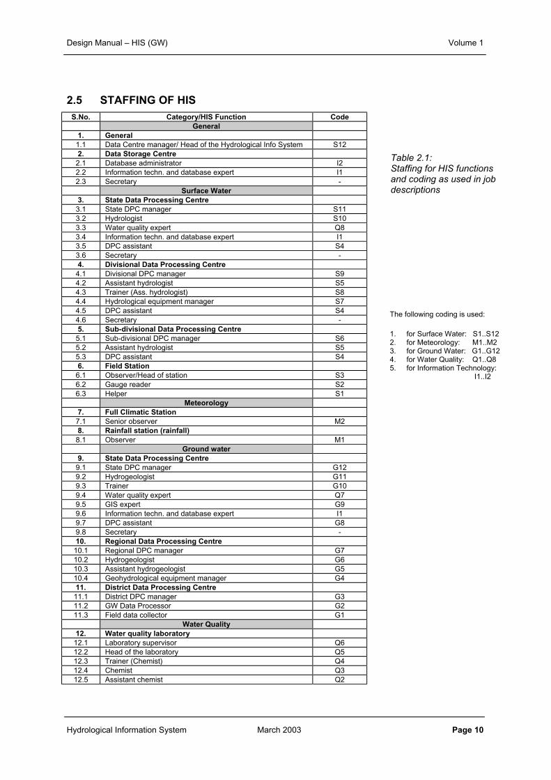
2.5 STAFFING OF HIS
S.No. Category/HIS Function CodeGeneral
1. General1.1 Data Centre manager/ Head of the Hydrological Info System S122. Data Storage Centre
2.1 Database administrator I22.2 Information techn. and database expert I12.3 Secretary -
Surface Water3. State Data Processing Centre
3.1 State DPC manager S113.2 Hydrologist S103.3 Water quality expert Q83.4 Information techn. and database expert I13.5 DPC assistant S43.6 Secretary -4. Divisional Data Processing Centre
4.1 Divisional DPC manager S94.2 Assistant hydrologist S54.3 Trainer (Ass. hydrologist) S84.4 Hydrological equipment manager S74.5 DPC assistant S44.6 Secretary -5. Sub-divisional Data Processing Centre
5.1 Sub-divisional DPC manager S65.2 Assistant hydrologist S55.3 DPC assistant S46. Field Station
6.1 Observer/Head of station S36.2 Gauge reader S26.3 Helper S1
Meteorology7. Full Climatic Station
7.1 Senior observer M28. Rainfall station (rainfall)
8.1 Observer M1Ground water
9. State Data Processing Centre9.1 State DPC manager G129.2 Hydrogeologist G119.3 Trainer G109.4 Water quality expert Q79.5 GIS expert G99.6 Information techn. and database expert I19.7 DPC assistant G89.8 Secretary -10. Regional Data Processing Centre
10.1 Regional DPC manager G710.2 Hydrogeologist G610.3 Assistant hydrogeologist G510.4 Geohydrological equipment manager G411. District Data Processing Centre
11.1 District DPC manager G311.2 GW Data Processor G211.3 Field data collector G1
Water Quality12. Water quality laboratory
12.1 Laboratory supervisor Q612.2 Head of the laboratory Q512.3 Trainer (Chemist) Q412.4 Chemist Q312.5 Assistant chemist Q2
Table 2.1:Staffing for HIS functionsand coding as used in jobdescriptions
The following coding is used:
1. for Surface Water: S1..S122. for Meteorology: M1..M23. for Ground Water: G1..G124. for Water Quality: Q1..Q85. for Information Technology:
I1..I2
Page 10
Design Manual – HIS (GW) Volume 1
Hydrological Information System March 2003 Page 11
In Table 2.1 an overview is given of the HIS functions, their requirement in the field stations/officesand in the data centres, and the coding as used in the job descriptions. The job descriptionsassociated with these functions are presented in the Chapter 1 of Volume 1, Field Manual, HIS.
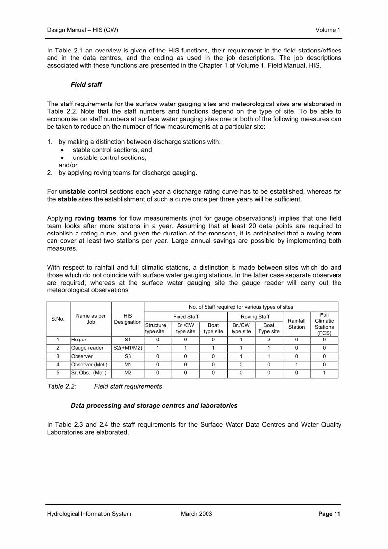
Field staff
The staff requirements for the surface water gauging sites and meteorological sites are elaborated inTable 2.2. Note that the staff numbers and functions depend on the type of site. To be able toeconomise on staff numbers at surface water gauging sites one or both of the following measures canbe taken to reduce on the number of flow measurements at a particular site:
1. by making a distinction between discharge stations with:• stable control sections, and• unstable control sections,
and/or2. by applying roving teams for discharge gauging.
For unstable control sections each year a discharge rating curve has to be established, whereas forthe stable sites the establishment of such a curve once per three years will be sufficient.
Applying roving teams for flow measurements (not for gauge observations!) implies that one fieldteam looks after more stations in a year. Assuming that at least 20 data points are required toestablish a rating curve, and given the duration of the monsoon, it is anticipated that a roving teamcan cover at least two stations per year. Large annual savings are possible by implementing bothmeasures.
With respect to rainfall and full climatic stations, a distinction is made between sites which do andthose which do not coincide with surface water gauging stations. In the latter case separate observersare required, whereas at the surface water gauging site the gauge reader will carry out themeteorological observations.
No. of Staff required for various types of sites
Fixed Staff Roving StaffS.No.Name as per
JobHIS
DesignationStructuretype site
Br./CWtype site
Boattype site
Br./CWtype site
BoatType site
RainfallStation
FullClimaticStations(FCS)
1 Helper S1 0 0 0 1 2 0 0
2 Gauge reader S2(+M1/M2) 1 1 1 1 1 0 0
3 Observer S3 0 0 0 1 1 0 0
4 Observer (Met.) M1 0 0 0 0 0 1 0
5 Sr. Obs. (Met.) M2 0 0 0 0 0 0 1
Table 2.2: Field staff requirements
Data processing and storage centres and laboratories
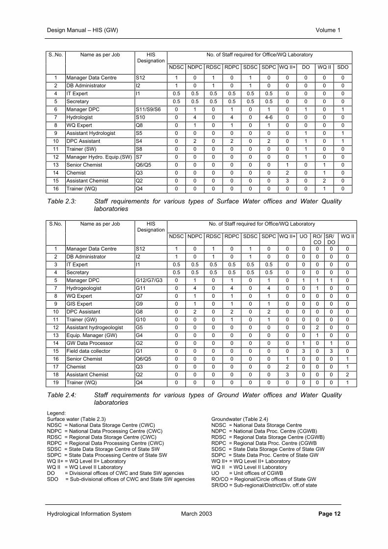
In Table 2.3 and 2.4 the staff requirements for the Surface Water Data Centres and Water QualityLaboratories are elaborated.
Design Manual – HIS (GW) Volume 1
Hydrological Information System March 2003 Page 12
S..No. Name as per Job HISDesignation
No. of Staff required for Office/WQ Laboratory
NDSC NDPC RDSC RDPC SDSC SDPC WQ II+ DO WQ II SDO
1 Manager Data Centre S12 1 0 1 0 1 0 0 0 0 0
2 DB Administrator I2 1 0 1 0 1 0 0 0 0 0
4 IT Expert I1 0.5 0.5 0.5 0.5 0.5 0.5 0 0 0 0
5 Secretary 0.5 0.5 0.5 0.5 0.5 0.5 0 0 0 0
6 Manager DPC S11/S9/S6 0 1 0 1 0 1 0 1 0 1
7 Hydrologist S10 0 4 0 4 0 4-6 0 0 0 0
8 WQ Expert Q8 0 1 0 1 0 1 0 0 0 0
9 Assistant Hydrologist S5 0 0 0 0 0 0 0 1 0 1
10 DPC Assistant S4 0 2 0 2 0 2 0 1 0 1
11 Trainer (SW) S8 0 0 0 0 0 0 0 1 0 0
12 Manager Hydro. Equip.(SW) S7 0 0 0 0 0 0 0 1 0 0
13 Senior Chemist Q6/Q5 0 0 0 0 0 0 1 0 1 0
14 Chemist Q3 0 0 0 0 0 0 2 0 1 0
15 Assistant Chemist Q2 0 0 0 0 0 0 3 0 2 0
16 Trainer (WQ) Q4 0 0 0 0 0 0 0 0 1 0
Table 2.3: Staff requirements for various types of Surface Water offices and Water Qualitylaboratories
S.No. Name as per Job HISDesignation
No. of Staff required for Office/WQ Laboratory
NDSC NDPC RDSC RDPC SDSC SDPC WQ II+ UO RO/CO
SR/DO
WQ II
1 Manager Data Centre S12 1 0 1 0 1 0 0 0 0 0 0
2 DB Administrator I2 1 0 1 0 1 0 0 0 0 0 0
3 IT Expert I1 0.5 0.5 0.5 0.5 0.5 0.5 0 0 0 0 0
4 Secretary 0.5 0.5 0.5 0.5 0.5 0.5 0 0 0 0 0
5 Manager DPC G12/G7/G3 0 1 0 1 0 1 0 1 1 1 0
7 Hydrogeologist G11 0 4 0 4 0 4 0 0 1 0 0
8 WQ Expert Q7 0 1 0 1 0 1 0 0 0 0 0
9 GIS Expert G9 0 1 0 1 0 1 0 0 0 0 0
10 DPC Assistant G8 0 2 0 2 0 2 0 0 0 0 0
11 Trainer (GW) G10 0 0 0 1 0 1 0 0 0 0 0
12 Assistant hydrogeologist G5 0 0 0 0 0 0 0 0 2 0 0
13 Equip. Manager (GW) G4 0 0 0 0 0 0 0 0 1 0 0
14 GW Data Processor G2 0 0 0 0 0 0 0 1 0 1 0
15 Field data collector G1 0 0 0 0 0 0 0 3 0 3 0
16 Senior Chemist Q6/Q5 0 0 0 0 0 0 1 0 0 0 1
17 Chemist Q3 0 0 0 0 0 0 2 0 0 0 1
18 Assistant Chemist Q2 0 0 0 0 0 0 3 0 0 0 2
19 Trainer (WQ) Q4 0 0 0 0 0 0 0 0 0 0 1
Table 2.4: Staff requirements for various types of Ground Water offices and Water Qualitylaboratories
Legend:Surface water (Table 2.3) Groundwater (Table 2.4)NDSC = National Data Storage Centre (CWC) NDSC = National Data Storage CentreNDPC = National Data Processing Centre (CWC) NDPC = National Data Proc. Centre (CGWB)RDSC = Regional Data Storage Centre (CWC) RDSC = Regional Data Storage Centre (CGWB)RDPC = Regional Data Processing Centre (CWC) RDPC = Regional Data Proc. Centre (CGWBSDSC = State Data Storage Centre of State SW SDSC = State Data Storage Centre of State GWSDPC = State Data Processing Centre of State SW SDPC = State Data Proc. Centre of State GWWQ II+ = WQ Level II+ Laboratory WQ II+ = WQ Level II+ LaboratoryWQ II = WQ Level II Laboratory WQ II = WQ Level II LaboratoryDO = Divisional offices of CWC and State SW agencies UO = Unit offices of CGWBSDO = Sub-divisional offices of CWC and State SW agencies RO/CO = Regional/Circle offices of State GW
SR/DO = Sub-regional/District/Div. off.of state
Design Manual – HIS (GW) Volume 1
Hydrological Information System March 2003 Page 13
In short, for the Surface Water Data Centres the listed staff will have the following tasks:
At Sub-divisional Data Processing Centre
• One data processing centre assistant for data entry and assistance job• One assistant hydrologist for carrying out primary data validation will be available.• The sub-divisional data processing centre manager will ensure the functioning of the Sub-
divisional Data Processing Centre.
At the Divisional Data Processing Centre
• One data processing centre assistant for data entry and assistance job• One assistant hydrologist for carrying out secondary data validation will be available.• The divisional data processing centre manager will ensure the functioning of Divisional Data
Processing Centre.
At the State/Regional Data Processing Centre
• Two data processing centre assistants for data entry and assistance job• 4-6 hydrologists (as per quantum of work, roughly one hydrologist per division) for accomplishing
final data validation, compilation and reporting activities will be available.• Support of water quality, database and information technology expert will also be available at the
centre.• The State/Regional Data Processing Centre manager will ensure the overall functioning of the
State/Regional Data Processing Centre.
At the State/Regional Data Storage Centre
• A data centre manager/head of the Data Storage Centre, who has the overall responsibility for theoperation of the Data Storage Centre, the DSC liase with the data providers and the data usersand administer/implement state/agency regulations and arrange data access privilege to users inaccordance with the regulations in force.
• A database administrator, who has the overall responsibility for the operation of the database andadministers the data input streams and data retrieval.
• Support of an information technology expert will be available,• Support staff for reception and secretarial work.
2.6 TIME SCHEDULE FOR DATA TRANSFER AND PROCESSING
Maintenance of a strict time schedule for all the data transfer from the field and processing activities atthe various data processing centres is of utmost importance for the following reasons:
• to take timely actions at the observation sites in case of error,• to create continuity in the processing activities at various data centres,• to accommodate regular exchange of data between the state and central agencies validating the
data of the same drainage/ basin• to ensure timely availability of authenticated data for use in planning, design and operation.
Hence, it is all the more important that activities at all the data processing centres are carried out intime. The time schedule for the completion of activities at various data processing centres is as givenbelow.
Design Manual – HIS (GW) Volume 1
Hydrological Information System March 2003 Page 14
•
At the Divisional/District Data Processing Centres
• The data of any month from all District/Divisional /Sub-divisional Data Processing Centres underits jurisdiction must be available by 15 days after scheduled date of collection.
• The primary and secondary data validation should also be completed by the prescribed period.The field and processed data sets along with the primary and secondary validation reports foreach month must leave the district/ divisional data processing by the end date of every month
At the State/Regional Data Processing Centre
• The data of any previous month from all the divisional/district data processing centres of thestate/region must be available by the 5th of the next month. That is to say that the data sets ofJune (both field data and partly validated data) must reach the State/Regional Data ProcessingCentre by 5th August.
• Within 15 days the field data set must be validated and transferred to the Data Storage Centre,i.e. the data of June should be available at the Data Storage Centre not later than 20th August.
• At the Data Processing Centre all the required actions must be completed on the incremental datasets by the last date of the month in which the data has been received, so the observed data ofJune is completed at the State/Regional Data Processing Centre by 31 August. These data will beheld as a provisional processed data-set until the end of the hydrological year, when they will beforwarded to the State/Regional Storage Centre as a confirmed (authenticated) data-set forgeneral dissemination to users.
At the State/Regional Data Storage Centre
• Both field and fully processed and validated data will be held at the State/Regional StorageCentre
• Field data sets will be received within 8 weeks after the month in which the data have beencollected.
• Fully processed and validated data will be received within three months after the end of the wateryear and made available for general dissemination. Only under exceptional circumstances willvalidated data from the State/Regional Data Storage Centre be retrieved for correction at theState/Regional Data Processing Centre.
Design Manual – HIS (GW) Volume 1
Hydrological Information System March 2003 Page 15
Inter-agency/inter-level meetings
There must also be at least two meetings every year in which different agencies, which operate in theregion, discuss the consistency of the data sets between the agencies and finalise them. For the datapertaining to June-December and January-May such meetings must be concluded by the end ofFebruary and August each year, respectively. Before such finalisation the processed data sets mustbe considered as of provisional nature only.
A higher frequency of exchange of views on data interpretation between the various parties within theorganisation and between the organisations working in the same region is essential and should bestimulated.
3 DATA USERS AND DATA REQUIREMENTS
3.1 GENERAL
In the set up of the Hydrological Information System the first question to be addressed is the type ofinformation to be provided. This determines the layout of the observation network (parameters,network density, observation frequency, equipment, etc.) and the data available in the databases. Thetype of information to be provided requires an analysis of the potential hydrological data users. TheCentral and State Government agencies, which support the Hydrological Information System, are themajor users of the generated information. There are scores of other governmental, non-governmentaland private agencies also, which make good use of this information. It is obvious that the hydrologicaldata needs, of the users, also change over time. Therefore, it is very important to identify the potentialdata users and regularly analyse their data needs. Normally, it is expected that the hydrologicalinformation service agencies satisfy most of the genuine data needs of the potential users in particularand society at large. For ensuring an optimal use of the public resources spent for maintaining such aHydrological Information Service, it is therefore very essential to have a proper balance between thedata needs of various users and mandate of various services supporting the hydrological informationsystem.
To ensure that the HIS output remains at all times ‘demand driven’ each state/agency hasconstituted a Hydrological Data User Group (HDUG). These HDUGs must represent all potentialusers within the State or intended to be covered by an agency.
To arrive at an HIS which complies with the objectives a thorough analysis of data user needs isrequired along the following steps:
• Identification of mandates of Hydrological Service agencies• Assessment of hydrological data users and their data needs, and• Preparation of a Hydrological Information Needs document.
These elements will be dealt with in the subsequent sub-sections. Finally a Working Plan for theHydrological Data User Group is set up.
3.2 MANDATE OF HYDROLOGICAL SERVICE AGENCIES
The prime objective of any information system is to fulfil the needs of its users within the framework ofits mandate. Different agencies operating various hydrological and meteorological networks havespecified mandates for their hydrological information services. The first important issue is to reviewthese goals for each of such services operative in the region. The definitive statements on the scopeof each of the services would form the criteria for deciding which of the data needs of the users canbe satisfied by the HIS. Normally, the scope of an agency with respect to HIS is spelt out in very
Design Manual – HIS (GW) Volume 1
Hydrological Information System March 2003 Page 16
broad terms and it is possible to incorporate most of the demands of the data users. However, incases where the existing mandate of an agency is not covering certain requirements of the users andthe hydrological data users group also consider such requirements to be met by the HIS then thesame should be formally brought to the notice of the concerned agency. The agency must thenconsider the matter for possible extension of its mandate with respect to HIS.
3.3 ASSESSMENT OF DATA REQUIREMENTS
The next step is to ascertain what is really required by the users. Often, this aspect is overlooked andit is taken that the information being provided is the same, which is required by the potential users. Itis obvious that user needs change from time to time and the HIS would fulfil its commitment only ifthere is a continual review or assessment of the changing needs of the users. The assessment startswith an analysis of the objectives, functions of Water Resources Management (as related to planningand design). It is possible to make a direct link between the objectives of water resourcemanagement and use functions of the water system and the type of data that is needed from theHydrological Information System.
Objectives, functions and activities of Water Resource Management
Based on the National Water Policy and overlying strategic national/state plans a concise objective ofthe water resources development in the country and in the states can be formulated. Such a specificstatement on the objectives if formulated is likely to contain the elements as mentioned in the box.
These objectives of water resource management and use functions of the water system are linked tothe type of data that is needed from the Hydrological Information System, which is outlined (as anexample) in Table 3.1.
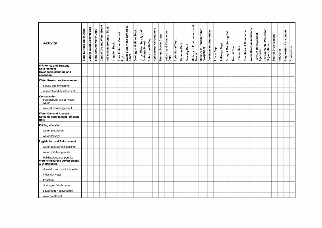
However, from an analysis point of view Table 3.1 has only an illustrative value. It will be needed todefine the activities that are related to these objectives/use functions and the institutions involved.Following gives a possible classification of such activities:
• WR Policy and Strategy Development• River-basin planning and allocation• Water Resources Assessment• Conservation• Water Demand Analysis
Objectives WRM:• to protect human life and economic functions
against flooding• to maintain ecologically sound water-systems• to support use functions
Use functions:• drinking and municipal water supply• irrigation• industrial water supply• water quality assessment• drought management• fisheries• hydropower production• shipping• discharge of effluents (incl. cooling water)• recreation
Design Manual – HIS (GW) Volume 1
Hydrological Information System March 2003 Page 17
• Demand Management (efficient use)• Pricing of water• Legislation and Enforcement• Water Resources Development and Distribution• Monitoring• Research
This classification should be adjusted to National/State situation by looking at the priorities (followingfrom the policies mentioned above) and the institutional setting. Furthermore it will be required todefine sub-activities.
Objective / function Data requirements from HIS (examples)
Drinking water supplyMunicipal water supply
• resource assessment and design studies require data onwater quantity and quality, e.g. temporal distribution ofgroundwater levels, river flows,.
Agriculture- irrigation- rain-fed agriculture
• assessment and design studies (reservoirs, intakes,irrigation schemes, etc.) require data on water quantityand quality data, including extreme rainfall and river flows(spillways), historical river regime (reservoirs) andsediment transport.
• for the operation planning of the system data on waterdemands, rainfall, river stages and flows (quantity andquality) are needed. Real-time data and forecasts arehowever not provided by the HIS
• Protection:- flooding- drainage
• design studies (e.g. embankments along rivers andcanals, culverts and bridges to bypass floods underroads-railways) require data on temporal and spatialdistribution of extreme rainfall, on discharge extremes andriver stages;
• flood early warning systems require the same kind ofinformation
Ecological sound water systems:- ecology- forestry- erosion
• assessment and habitat studies require data on thenatural river stage and flow dynamics, flow velocities,variation of groundwater levels, water quality and ofanthropogenic effects;
• forestry/erosion require data on rainfall, evaporation,variation of river stage/groundwater levels and on quality.
Fisheries • assessment and suitability studies require data on waterdepth, flow velocities and water quality.
Hydropower production • the design and operation of micro, mini and macro-hydropower systems, often in combination with water usefor irrigation and flood mitigating measures require dataon water quantity and quality data, including extremerainfall and river flows (spillways), historical river regime(reservoirs) and sediment transport.
• for the operation of the system data on water demands,rainfall, river stages and flows (quantity and quality) inreal-time and as forecasts are needed. Such data arehowever not provided by the HIS
Shipping • Design and maintenance require information on waterdepth, flow velocities, sedimentation (note: inlandshipping is of minor importance in India).
Industrial water supply • Availability studies (for process and cooling water) requireinformation comparable to drinking water supply.
Discharge of effluents • Licensing and monitoring require data on flows, variouswater quality parameters.
Design Manual – HIS (GW) Volume 1
Hydrological Information System March 2003 Page 18
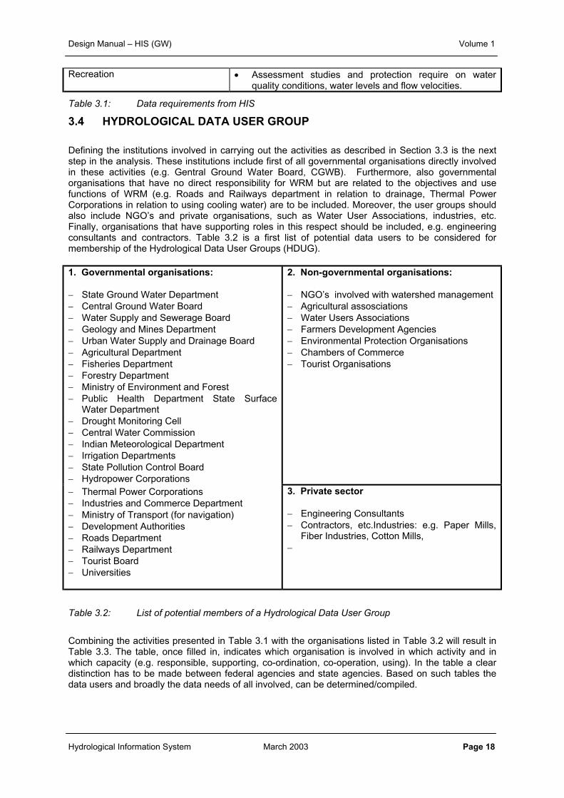
Recreation • Assessment studies and protection require on waterquality conditions, water levels and flow velocities.
Table 3.1: Data requirements from HIS
3.4 HYDROLOGICAL DATA USER GROUP
Defining the institutions involved in carrying out the activities as described in Section 3.3 is the nextstep in the analysis. These institutions include first of all governmental organisations directly involvedin these activities (e.g. Gentral Ground Water Board, CGWB). Furthermore, also governmentalorganisations that have no direct responsibility for WRM but are related to the objectives and usefunctions of WRM (e.g. Roads and Railways department in relation to drainage, Thermal PowerCorporations in relation to using cooling water) are to be included. Moreover, the user groups shouldalso include NGO’s and private organisations, such as Water User Associations, industries, etc.Finally, organisations that have supporting roles in this respect should be included, e.g. engineeringconsultants and contractors. Table 3.2 is a first list of potential data users to be considered formembership of the Hydrological Data User Groups (HDUG).
1. Governmental organisations:
− State Ground Water Department− Central Ground Water Board− Water Supply and Sewerage Board− Geology and Mines Department− Urban Water Supply and Drainage Board− Agricultural Department− Fisheries Department− Forestry Department− Ministry of Environment and Forest− Public Health Department State Surface
Water Department− Drought Monitoring Cell− Central Water Commission− Indian Meteorological Department− Irrigation Departments− State Pollution Control Board− Hydropower Corporations
2. Non-governmental organisations:
− NGO’s involved with watershed management− Agricultural assosciations− Water Users Associations− Farmers Development Agencies− Environmental Protection Organisations− Chambers of Commerce− Tourist Organisations
− Thermal Power Corporations− Industries and Commerce Department− Ministry of Transport (for navigation)− Development Authorities− Roads Department− Railways Department− Tourist Board− Universities
3. Private sector
− Engineering Consultants− Contractors, etc.Industries: e.g. Paper Mills,
Fiber Industries, Cotton Mills,−
Table 3.2: List of potential members of a Hydrological Data User Group
Combining the activities presented in Table 3.1 with the organisations listed in Table 3.2 will result inTable 3.3. The table, once filled in, indicates which organisation is involved in which activity and inwhich capacity (e.g. responsible, supporting, co-ordination, co-operation, using). In the table a cleardistinction has to be made between federal agencies and state agencies. Based on such tables thedata users and broadly the data needs of all involved, can be determined/compiled.
Activity
Sta
te S
urf
ace
Wat
er D
ept.
Cen
tra
l Wat
er C
om
mis
sio
n
Sta
te G
rou
nd
Wat
er D
ept.
Cen
tral
Gro
un
d W
ater
Bo
ard
Ind
ian
Met
eoro
log
ical
Dep
t.
Irri
gat
ion
Dep
t.
Sta
te P
oll
uti
on
Co
ntr
ol
Bo
ard
Wat
er S
up
ply
an
d S
ewer
age
Bo
ard
Geo
log
y an
d M
ines
Dep
t.
Urb
an W
ater
Su
pp
ly a
nd
Dra
inag
e B
oar
d
Pu
bli
c H
ea
lth
Dep
t.
Hyd
rop
ow
er C
orp
ora
tio
ns
Th
erm
al P
ow
er C
orp
s.
Ind
ust
ries
& C
om
mer
ceD
ept.
Ag
ricu
ltu
ral
Dep
t..
Fis
her
ies
Dep
t.
Fo
rest
ry D
ep
t.
Min
istr
y o
f E
nvi
ron
men
t an
dF
ore
st
Min
istr
y o
f T
ran
spo
rt (
for
nav
igat
ion
)
Dev
elo
pm
ent
Au
tho
riti
es
Ro
ads
Dep
t.
Rai
lwa
ys D
ept.
Dro
ug
ht
Mo
nit
ori
ng
Cel
l
To
uri
st B
oar
d
Un
ive
rsit
ies
Ch
amb
ers
of
Co
mm
erce
Wat
er U
sers
Ass
oci
atio
ns
Far
mer
s D
evel
op
men
tA
ge
nci
es
En
viro
nm
enta
l P
rote
ctio
nO
rgan
izat
ion
s
To
uri
st O
rgan
izat
ion
s
Ind
ust
ries
En
gin
eeri
ng
Co
nsu
ltan
ts
Co
ntr
acto
rs.
WR Policy and StrategyDevelopmentRiver basin planning andallocation
Water Resources Assessment
survey and monitoring
research and development
Conservationtreatment/re-use of (waste-water)
watershed management
Water Demand AnalysisDemand Management (efficientuse)
Pricing of water
water abstraction
water delivery
Legislation and Enforcement
water abstraction licensing
water pollution permits
building/land-use permitsWater Resources Development& Distribution
domestic and municipal water
industrial water
Irrigation
drainage / flood control
sewareage / conveyance
water treatment
Design Manual – HIS (GW) Volume 1
Hydrological Information System March 2003 Page 20
Through a process of group meetings, individual interviews and review meetings, identification of theusers’ need is to be ascertained. The HDUG meeting itself is not a proper platform to identify in detailthe individual data needs. A more efficient procedure is a critical assessment through small interviewteams, who explore in bilateral talks the mandates and data needs of the potential data users. In theinterview teams both state surface and groundwater organisations are represented. To guide and stre-amline the discussions a questionnaire has been prepared, to be filled in during visit to the data user,addressing items like:• description of data user (name, sector, mandate, provided services, staffing and financing).• water system use (present and future) with respect to quantity and quality, and responsibility.• data use and requirements (parameters, type, frequency of availability, in what form, accuracy,
consequences if not available, appreciation of present status of data supply.
The full questionnaire with the suggested approach to be followed by the interview team is presentedin the Part III of Volume 1, Field Manual, HIS, ‘Data needs assessment’.
A document on Hydrological Information Needs (HIN) should be brought out at the end of thisexercise after adequate consideration of the mandate of the hydrological services operative within aState or agency and also the identified needs of the users. Reference is made to the Part IV ofVolume I, Field Manual, HIS showing a standard Table of Contents for the HIN. This exercise ofhaving a formal assessment is a continual process wherein the review is made periodically at aspecified interval of time (say every five years) and whenever there is an apparent or urgent need.
The ‘Terms of Reference’ (ToR) document in respect of constitution and functioning of the HDUGslays down a broad framework of operational guidelines, so that a consistent and uniform approach forthe management of HDUGs is adopted, across the states and central agencies where HIS isoperational. Reference is made to the Part II, Volume 1, Field Manual, HIS for a completepresentation of the ToR for HDUG.
The ToR lists the overall purpose of setting up state and central level Hydrology Data Users Groups(HDUGs) as:
• To provide a common platform for interaction between hydrology data users and data providers.• To create awareness amongst users about HIS data and educate them on the potentials and
limitations of HIS.• To understand, analyse and update information on the changing needs of data users from a
macro level perspective.• To review and recommend additions/deletions in the data collection networks and related HIS, if
appropriate.• HDUGs can also focus on technology changes that may warrant changes in monitoring and data
management.
The role of an HDUG is twofold:
• advisory role and• demand - supply linkage role
The recommended size of an HDUG in each state or central agency is approximately 25 to 30members, representing governmental agencies (15 to 20 members) and voluntary organisations andprivate establishment (8 to 10 members). The specific criteria for selection of members from the threecategories are detailed out in the annex to the ToR.
The ToR further specifies regulations governing the HDUG including position, membership andoperational clauses and list out the scope activities in the advisory capacity and in the demand-supplylinking role.

Design Manual – HIS (GW) Volume 1
Hydrological Information System March 2003 Page 21
3.5 WORKING PLAN OF HDUGs
For each State there has to be one HDUG representing the Surface water and Groundwater relateddepartments and users. Similarly, at the National level, one HDUG representing CWC, CGWB andusers from potential sectors has been formed. The Convenor of the HDUGs at the States is theoverall incharge of the State Data Storage Centre of the rank of Chief Engineer. If the Groundwaterand Surface Water Data Storage Centres are separate in the State then the Incharges of thesebecome the convenors of HDUG by rotation. Similarly, at the National level also, the overall inchargesof the National Data Centres at CWC and CGWB, of the rank of Chief Engineer, act as Convenors ofHDUG by rotation. The term for rotation should be the same as frequency of review. The overallresponsibility of bringing out the HIN document and convey its recommendations to all the concernedagencies lies with the Convenor of the Group.