download e-copy
TRANSCRIPT

Andaman and Nicobar IslandsIndia’s Untapped Strategic Assets

Andaman and Nicobar IslandsIndia’s Untapped Strategic Assets
Sanat Kaul
INSTITUTE FOR DEFENCE STUDIES & ANALYSES
NEW DELHI
Pentagon PRess
Andaman and Nicobar Islands: India’s Untapped Strategic Assets
By Sanat Kaul
First Published in 2015
Copyright © Institute for Defence Studies and Analyses, New Delhi
ISBN 978-81-8274-774-6
All rights reserved. No part of this publication may be reproduced, stored in a retrievalsystem, or transmitted, in any form or by any means, electronic, mechanical,photocopying, recording, or otherwise, without first obtaining written permission ofthe copyright owner.
Disclaimer: The views expressed in this book are those of the author and do notnecessarily reflect those of the Institute for Defence Studies and Analyses, or theGovernment of India.
Published by
PENTAGON PRESS206, Peacock Lane, Shahpur Jat,New Delhi-110049Phones: 011-64706243, 26491568Telefax: 011-26490600email: [email protected]: www.pentagonpress.in
Branch:Prime ArcadeOffice #111154 Saifee StreetOpp. M.G. Road, CampPune-411001Email: [email protected]
In association withInstitute for Defence Studies and AnalysesNo. 1, Development Enclave,New Delhi-110010Phone: +91-11-26717983Website: www.idsa.in
Printed at Avantika Printers Private Limited.
Contents
Preface ix
Abbreviations xi
List of Maps, Photographs and Table xiii
1. Introduction 1
2. Background of Andaman & Nicobar Archipelagos 18Maps and Distances 18Background of Andaman Islands 21Some Features of Port Blair 24The Andaman Story 25History of Nicobar Islands 28The Credibility of R. Akoojee Jadwet & Company 411947: India becomes Independent 422004 Tsunami and the Nicobar Islands: Role of Ellon Henongo 51Conclusion 53
3. Importance of Straits of Malacca 55Why Straits of Malacca is the Preferred Option? 55Piracy and its Implications for Andaman & Nicobar Islands and Straits ofMalacca 57China’s Malacca Dilemma 62Malacca Dilemma: Finding alternatives to Straits of Malacca 65Alternative 1The Myanmar Alternative 66Alternative 2KRA Canal 69Alternative 3Gwadar Port 71Alternative 4Malaysian Alternative 73Alternative 5 74
4. The International Law of the Sea and India’s Maritime
Legislative History 77Developments Till 1965 77
Andaman and Nicobar Islandsvi
Post-Independence India 77UNCLOS I—1958 79UNCLOS II—1960 80Developments After 1965 80Maritime Act, 1976 81UNCLOS III—1973-82 82The outcome of UNCLOS III—The 1982 Conventionon the Law of the Sea 83Maritime Boundaries 85Agreements with Littoral Neighbours 87Tri-junction Agreements 87
5. South China Sea 90Chinese Policy of Declaring Core Interest and the Camouflage ofPeaceful Rise 90Basis of Chinese Claims over South China Sea 90China’s Status under UNCLOS III and Disputes with itsMaritime Neighbours 94
6. Rise of Regional Groupings in Indo-Pacific Region:
Civil Initiative 108Introduction 108ASEAN—A True Indo-Pacific Regional Group 108BIMSTEC 112Indian Ocean Rim – Association for RegionalCooperation (IOR-ARC) 113Mekong Ganga Project 116Conclusion 116
7. Indian Naval Diplomacy and Defence Initiatives 118Milan Exercise 118Indian Ocean Naval Symposium (IONS) 120Malabar Exercise 121SIMBEX with Singapore 121JIMEX with Japan 122
8. A Strategic Shift in India’s Defence Policy Post-LEP 1991
and Andaman & Nicobar Islands 126US Tilt Towards India 126India and Japan: Convergence of Views 127India and Australia 128China in Indian Ocean Region 129Chinese Apprehension 131The ASEAN Conundrum 132China-India Conflict in South China Sea 133
viiContents
Post-26/11 Developments and the Andaman & Nicobar Islands 133Mumbai Attack: Lessons 137History of Defence Establishment inAndaman & Nicobar Islands 140The Forward Policy in the Indo-Pacific 144
9. Leveraging Soft Power: A Tourism Policy for Andaman &
Nicobar Islands that
Compliments the Forward Policy 146Complementarity between Tourism and Security 146Complementarity between Environment and Security 147Trade-off between Security and Environment 148Present Civil Policy—Environmental Issues Dominate 148Supreme Court of India and Environment ofAndaman & Nicobar Islands 148Environmental Concerns and Development 150Island Development Authority (IDA) 151Environment and Tourism: The Soft Option 153Why Tourism? 153Draft Tourism Policy 163The Final Version of Tourism Policy 170Comparative Tourism Policies of Select Countries 171
10. Andaman & Nicobar Islands—Strategic Challenges:
A Proposed Policy Prescription 179Integrating Andaman & Nicobar Islands with LEP 180Soft Power Option 180National Security and Uninhabited Islands 182Scuba Diving a Source of Surveillance andEnvironmental Protection 183Policy Towards Nicobar Islands 185Mass Tourism Versus High Value Tourism 186Locating Tourism Sites with Strategic Value 187Issues of Connectivity to Andaman & Nicobar Islands 187Domestic Air Connectivity: Government of India Policy onConnecting Remote Locations 188Direct International Connectivity 189MoU with Phuket: Sister Cities 191Telecom Connectivity 192The Indo-Pacific and the Nicobar Islands—Strategic Angle 193
Appendices
1. The Boundary Agreement Between China and Pakistan,
March 1963 198

Andaman and Nicobar Islandsviii
2. Memorandum of Understanding Between Phuket Chamber of
Commerce and Andaman Chamber of Commerce and
Industry, November 2003 202
3. Agreement of Friendship/Cooperation Between City of Port
Blair and Phuket Province, June 2005 204
Bibliography 207
Index 209
ixContents
Preface
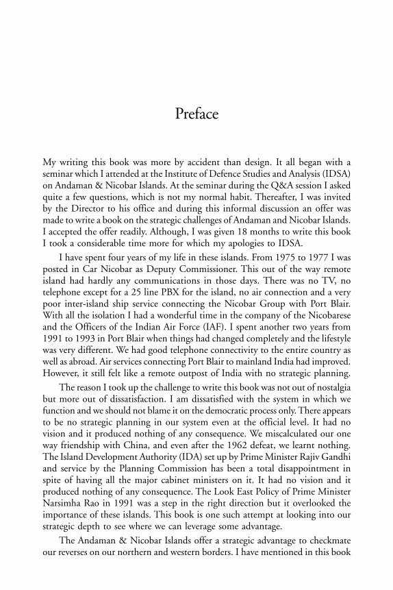
My writing this book was more by accident than design. It all began with aseminar which I attended at the Institute of Defence Studies and Analysis (IDSA)on Andaman & Nicobar Islands. At the seminar during the Q&A session I askedquite a few questions, which is not my normal habit. Thereafter, I was invitedby the Director to his office and during this informal discussion an offer wasmade to write a book on the strategic challenges of Andaman and Nicobar Islands.I accepted the offer readily. Although, I was given 18 months to write this bookI took a considerable time more for which my apologies to IDSA.
I have spent four years of my life in these islands. From 1975 to 1977 I wasposted in Car Nicobar as Deputy Commissioner. This out of the way remoteisland had hardly any communications in those days. There was no TV, notelephone except for a 25 line PBX for the island, no air connection and a verypoor inter-island ship service connecting the Nicobar Group with Port Blair.With all the isolation I had a wonderful time in the company of the Nicobareseand the Officers of the Indian Air Force (IAF). I spent another two years from1991 to 1993 in Port Blair when things had changed completely and the lifestylewas very different. We had good telephone connectivity to the entire country aswell as abroad. Air services connecting Port Blair to mainland India had improved.However, it still felt like a remote outpost of India with no strategic planning.
The reason I took up the challenge to write this book was not out of nostalgiabut more out of dissatisfaction. I am dissatisfied with the system in which wefunction and we should not blame it on the democratic process only. There appearsto be no strategic planning in our system even at the official level. It had novision and it produced nothing of any consequence. We miscalculated our oneway friendship with China, and even after the 1962 defeat, we learnt nothing.The Island Development Authority (IDA) set up by Prime Minister Rajiv Gandhiand service by the Planning Commission has been a total disappointment inspite of having all the major cabinet ministers on it. It had no vision and itproduced nothing of any consequence. The Look East Policy of Prime MinisterNarsimha Rao in 1991 was a step in the right direction but it overlooked theimportance of these islands. This book is one such attempt at looking into ourstrategic depth to see where we can leverage some advantage.
The Andaman & Nicobar Islands offer a strategic advantage to checkmateour reverses on our northern and western borders. I have mentioned in this book

Andaman and Nicobar Islandsx
that if a proper policy is drawn and implemented we could, perhaps, turn thetables on the Chinese. This will happen only if we carefully leverage the potentialthat these islands offer. With Great Nicobar Island near the western entrance ofthe Malacca Strait and India’s relationship with its eastern neighbours in goodhealth, we have potential to increase our strategic depth in Indo-Pacific. Thebook describes the Chinese Malacca Dilemma which could be our advantage.
Finally, I have tried to show what India achieved in the North East in the1950s by a policy driven initiative by creating the North East Frontier Agency(NEFA) with the mandate to have effective jurisdiction up to the McMahonline. This finally led to successful creation of Arunachal Pradesh. By pursuinganother policy driven initiative for these islands we could leverage the latentpotential. This can be achieved by creating a new administrative setup.
I am grateful to Lt. General Bhopinder Singh, Lt. Governor of these islandsduring my visit in 2012 for his frank discussion. I am also grateful to Lt. GeneralMarwah Commander-in-Chief of the Unified Command (CINCAN), ViceAdmiral Murlidharan DG Coast Guards, Mr. Anand, the current Chief Secretary,Mr. Vivek Rae and Mr. Shakti Sinha, the former Chief Secretaries of Andamanand Nicobar Islands. Admiral Arun Prakash, the Former Chief of Naval Staff,Admiral Premvir Das, former Fortress Commander and the current Deputy Chiefof Naval Staff. I am also thankful to Mr. Sanjay Singh, former Secretary Ministryof External Affairs (MEA), Ms. Navreka Sharma, India’s former Ambassador toIndonesia, and Ms. Veena Sikri and Mr. Rajiv Mittal India’s former Ambassadorsto Bangladesh. I am also grateful to Mr. Naresh Chandra former Cabinet, Homeand Defence Secretary as well as India’s Ambassador to US for discussing withme some finer points of my hypothesis and giving suggestions.
I am grateful to Sheela Bajaj Sahi who went through the draft and offereduseful suggestions. I am also grateful to Air Marshal Naresh Verma, who hasbeen a dear friend since our days together in Car Nicobar for fixing manyappointments. I am, however, most grateful to Prof. D.B. Gupta, currently atNational Council of Applied Economic Research (NCAER), who went througheach page of my draft meticulously and offered suggestions. The staff of IDSAhas been very helpful especially Ms Sumita Kumar and Mr. Vivek Dhankar. Iwould also like to make a special mention of Mandeep Singh Gauri who helpedme with the typing, corrections and computer work for which I am very gratefulto him. Thanks are also due to my wife Ranjana and daughter Mahima who putup with my excuses for not doing work relating to her marriage and to my sonIshan, who during his visit from London, where he lives, went through someparts of the draft. Finally, my thanks goes to Shri N.S. Sisodia, the former Director-General of IDSA who offered this book project to me and Dr. Arvind Gupta thecurrent Director-General who has been extremely helpful in all matters and tookkeen interest in the progress of my work.
Sanat Kaul
xiContents
Abbreviations
ASEAN Association of South East Nations
CICIR China Institute of Contemporary International Relations
DGCA Director General Civil Aviation
EEZ Exclusive Economic Zone
EHL Ellong Hinengo Limited
GNI Great Nicobar Island
IMB International Maritime Bureau
IMO International Maritime Organisation
IOR Indian Ocean Region
LAC Line of Actual Control
LEP Look East Policy
LOC Line of Control
LTC Leave Travel Concession
LTTE Liberation Tigers of Tamil Elam
MEA Ministry of External Affairs
MHA Ministry of Home Affairs
MOU Memorandum of Understanding
NDU National Defence University
NEFA North East Frontier Agency
NM Nautical Miles
NSA National Security Advisor
ONGC Oil and Natural Gas Commission
PLA Peoples Liberation Army
PLAN Peoples Liberation Army Navy
PRC Peoples Republic of China (Mainland China)
RC Republic of China (Taiwan)

Andaman and Nicobar Islandsxii
SLOC Sea Lanes of Communications
UN United Nations
UNDP United Nations Development Programme
UNGA United Nations General Assembly
xiiiContents
List of Maps, Photographs and Table
Map 1: Chinese Territorial Claims over India and South China Sea 2
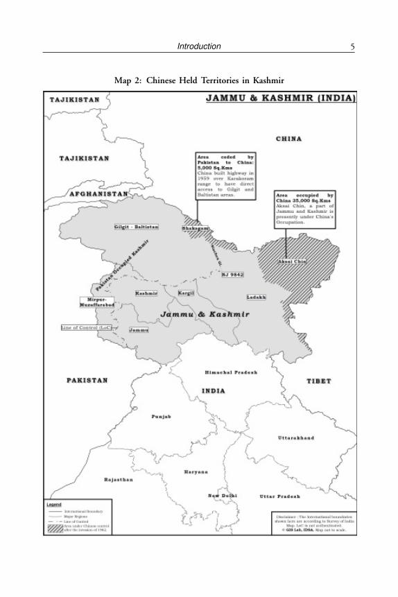
Map 2: Chinese Held Territories in Kashmir 5
Map 3: India-Malacca and South-China Sea 7
Map 4: Andaman Islands 19
Map 5: Connectivity to Andaman & Nicobar Islands 23
Map 6: Background of Nicobar Islands 28
Map 7: Oil Transit Chokepoints 56
Map 8: Location of Attacks in the Malacca and Singapore Straits,2000-05 59
Map 9: The Myanmar Alternative 66
Map 10: Straits of Malacca 70
Map 11: Gwadar to China Pipeline 72
Map 12: Bangladesh’s Low Water Baseline Perceived byIndia and Myanmar 78
Map 13: Maritime Borders between India-Indonesia-Thailand 88
Map 14: Chinese Claims over South China Sea 91
Map 15: China’s Claims over India 93
Photo 1: Rt. Rev. Bishop Richardson 27
Photo 2: The Author with Chief Captain Kuchat in Car Nicobarin 1975-77 42
Table 1: Benchmarking of Andaman & Nicobar Islands vis-a-vis LargeTropical Island Nations 170

CHAPTER 1
Introduction
“I have carefully gone through the correspondence between External AffairsMinistry and our Ambassador in Peking and through him the ChineseGovernment. I have tried to pursue this correspondence as favourably to ourAmbassador and the Chinese Government as possible, but I regret to say thatneither of them has come out well as a result of this study. The ChineseGovernment has tried to dilute us by professions of peaceful intentions. My ownfeeling is that at a crucial period they managed to instil in our Ambassador afalse sense of confidence in their so called desire to settle the Tibetan problem bypeaceful means. There can be no doubt that during the period covered by thiscorrespondence the Chinese must have been concentrating for an onslaught onTibet. The final action of the Chinese, to my judgment, is little short of perfidy.The tragedy of it is that the Tibetans have put faith in us; they chose to beguided by us; and we have been unable to get them out the meshes of Chinesediplomacy or Chinese malevolence. From the latest position, it appears that weshall not be able to rescue Dalai Lama. Our Ambassador has been at great painto find an explanation or justification for the Chinese policy and actions.”
(Extract from Text of Sardar Vallabhbhai Patel, Deputy Prime Minister andHome Minister of India’s letter to Jawaharlal Nehru on November 7, 1950).
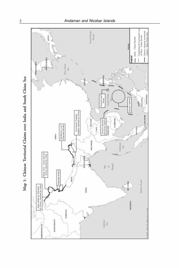
India as a country has a long land border with Pakistan, China and Nepal andalso with Myanmar and Bangladesh. In the north, the Himalayan Range providedthe barrier between India and Tibet but after the Chinese aggressive takeover ofTibet, the Chinese border has come in contact with the Indian border which isalways under tension. The 1914 McMahon Line drawn between India and Tibetis not acceptable to China as a border. With Pakistan there is a dispute overKashmir which has led to tension on the border. With Nepal, Bhutan, andMyanmar the borders are peaceful. With Bangladesh the border is peaceful thoughfull settlement is yet to be carried out. However, India also has island territoriesboth in the Arabian Sea and in the Bay of Bengal which are both peaceful. TheAndaman & Nicobar Islands are two archipelagos which form a chain betweenMyanmar and the Straits of Malacca and consist of 572 islands, islets and rocks.The importance of these islands which lie between Myanmar and the westernentrance of Straits of Malacca has not been fully appreciated from the strategic
Andaman and Nicobar Islands2M
ap 1
:C
hin
ese
Ter
rito
rial
Cla
ims
over
In
dia
an
d S
outh
Ch
ina
Sea
3Introduction
angle. This book is therefore, an examination of the advantages of leveragingthe potential of these islands in the present day security scenario in view of Chinaand Pakistan breathing down India’s neck.
The strategic importance of Andaman & Nicobar Islands can therefore, bediscussed in following ways:
• Chinese encirclement of India and our difficulties in North and West.The critical location of the Great Nicobar Island which gives ustremendous advantage over Straits of Malacca, a Sea Lane ofCommunication (SLOC) critical to trade and movement of oil fromGulf to South China Sea, East China Sea and the Pacific.
• The two archipelagos consisting of 572 islands, islets and rocks thatform a chain gives India its strategic and economic importance in theBay of Bengal as well as in the Indo-Pacific region.
• These islands also provide India with tremendous economic potentialfor tourism, fisheries, forests and enable India to add about 30 per centof its additional Exclusive Economic Zone (EEZ)1 post UNCLOS IIIof 1982 which will bring future benefits from undersea mining andpotential oil and gas.
• The advantage of India’s settled maritime boundaries with its neighboursin the east.
• India and growth of regional groups in the Indo-Pacific.• Naval diplomacy and defense initiatives in the Indo-Pacific.• Boosting our Look East Policy (LEP) of 1991.• Display of India’s soft power vis-à-vis the Indo-Pacific Region.
In order to appreciate the full strategic and economic value of these islands, it isnecessary to do a review of existing policies and strategic threats. There is a needto assess whether the policy of ‘Masterly Inactivity and Benign Neglect’ beingfollowed so far needs to be replaced by a policy of ‘Proactive Development’ byleveraging its potential with a forward strategic policy in mind. The comparativeanalysis with Mauritius, Caribbean Islands and even coastal resorts of Thailandlike that of Phuket is necessary to evaluate the hidden wealth of these islandsthrough controlled tourism. It may also be pointed out that out of a coastline of7,517 kms, a coastline of over 1,962 kms comes from the Andaman and Nicobararchipelagic chain of islands.
Late K.M. Panikkar, an intellectual and India’s Ambassador to China in thepre-communist regime in the late 1940s as well as to the communist regimestated in 1959 that the “possession of Andaman & Nicobars gives protection tothe East Coast and gives adequate control of the Bay of Bengal”. He had alsomentioned that “India should not neglect these islands and develop suitable navaland air force facilities.”2
Andaman and Nicobar Islands4
Historical Background to India-China Dispute
The strategic importance of Andaman & Nicobar Islands has to be seen in thelight of its proximity to the Straits of Malacca. The fact that Great Nicobar Islandis only 80 miles from the western entrance of Straits of Malacca has its ownimplications. The Chinese leadership is quite aware that whoever will controlthe Straits of Malacca will be able to choke the supply line of Peoples Republicof China (PRC). While the Indian land borders are embroiled in disputes andstalemates, it is its maritime borders that bring a ray of hope to resolving theissues and, perhaps, turning the tables. This is, therefore, an important issue forstrategic analysis.
Mistakes of the past have to be either forgotten or corrected. First, Indiamade its strategic mistake in referring the Kashmir incident of October 1947 tothe United Nations (UN), a matter which UN could not resolve; Second, Indiahelped China in building a road in Aksai Chin by providing food for their troopssent on mules from India over the Himalayas; Third, by recognition of Tibet as“a region of China” in the famous Panchsheel Agreement of 1954 without seekinga quid pro quo on the border issue, India unilaterally surrendered all its assets inTibet. These consisted of posts of Agents in Lhasa, Gyantse and Gartok, alongwith troops, about a dozen government rest houses and a telegraph line runningfrom Lhasa to India since the days of the Young Husband Expedition of 1904.This policy of giving into Chinese aggressive postures exists even now on theland frontier i.e. 4,057 km Line of Actual Control (LAC), one of the longest andhighest in the world to exert pressure on India. Over 600 “transgressions” implyingintrusions have been recorded over the years and a policy of appeasementcontinues. In this connection analysis by Claude Arpi, an India-China expert onChinese brazenness and India’s preference for continued engagement with China,is interesting where he has established that Chinese have realised that India hasbecome submissive by show of force.3
Having shocked India in 1962 by an armed aggression through a perceivedimpenetrable wall of the Himalayas in which they have still retained 35,000 sqkm of uninhabited territory in Ladakh (Aksai Chin), the Chinese withdrew inArunachal Pradesh (erstwhile NEFA) which they occupied in war, a territory of93,000 kms which they still claim as theirs. This is so because they do not acceptthe McMahon Line, signed at the Simla conference of 1914 between the British,Tibet and China. Over time the Chinese have built very good relations withIndia’s neighbours on the land frontiers. The boundary agreement signed betweenMyanmar (then Burma) and China in 1961 is on the basis of the McMahonLine of 1914, in spite of the Chinese claim of ‘unequal treaties’ with the British.4
They signed a boundary agreement with Pakistan in 1963 in which Pakistangave away 5000 sq km of land in Gilgit/Baltistan region, disputed territorybetween India and Pakistan to China. This takes the wind out of India’s diplomaticstrategy followed under Nehru. The McMahon line is the accepted international
5Introduction
Map 2: Chinese Held Territories in Kashmir
Andaman and Nicobar Islands6
boundary since 1914 when Simla Agreement was signed between India, Chinaand Tibet as equals. It is true that the Chinese representative who hadplenipotentiary power and letters of Credentials initialed the agreement but thegovernment of China did not ratify it. However, the Tibetan Representative,who sat as an equal with full plenipotentiary powers, signed the agreement basedon the McMahon Line.
The famous economist John Kenneth Galbraith, who was then theAmbassador of United States to India (selected by President John Kennedy),supported this line by his announcement on October 27, 1962 that that USsupports the McMahon Line. Again after 50 years, the US Ambassador to India,Nancy Powell, reconfirmed this in 2012 in Guwahati in India.5 The forciblemilitary occupation of independent Tibet by the Chinese forces from 1950-59,culminated in the Dalai Lama seeking refuge in India, something that SardarPatel, India’s Deputy Prime Minister predicted in his letter to Nehru.6
India under Nehru was, however, not prepared to take up the matter at theUN in spite of a request by the Tibetans in order not to offend the Chinese.7 Itwas El Salvador which took up the Tibetan case at the UN with a draft resolutionentitled “Invasion of Tibet by Foreign Forces” and lost as India was notforthcoming in its support. In 1961, Malay and Ireland joined El Salvador andThailand to request the UN to adopt a resolution on similar lines. US and UK,the then two major powers, looked to India to provide a lead in this issue butNehru was very lukewarm towards it and did not support the resolution.8 TheWestern powers, following Nehru’s lead, did the same in spite of the fact thatthey did not recognise the communist regime in China and the resolution nevergot passed. However, India gave refuge to Dalai Lama in 1959 which put India-China relations into a freeze which continues even now in spite of the rhetoricby the governments of either side that relations are improving and trade is booming(trade between India and China is yet another story). The net result was to bringChinese borders common with India’s. The prediction made by Sardar VallabhbhaiPatel, Deputy Prime Minister and Home Minister of India in a letter datedNovember 7, 1950, ignored by Nehru came through within a decade. The 1962War by China over their claim of Indian territory was a result of this issue. TheChinese War against India over the Himalayas was in two theatres—the EasternTheatre consisting of erstwhile NEFA (now called Arunachal Pradesh) and theWestern Theatre which is called Ladakh (a part of Jammu & Kashmir (J&K)state). After occupation of NEFA, the Chinese retreated fully in the eastern theatrebut they retained 5000 sq km in the western theatre. One reason for withdrawingfrom the eastern theatre was perhaps due to the effective administration of Indiaover the tribal population, which was not the case in the western theatre. Thiswill be further discussed in Chapters 9 and 10.
7Introduction
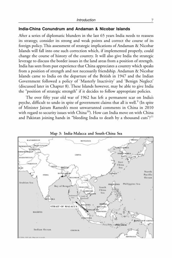
India-China Conundrum and Andaman & Nicobar Islands
After a series of diplomatic blunders in the last 65 years India needs to reassessits strategy, consider its strong and weak points and correct the course of itsforeign policy. This assessment of strategic implications of Andaman & NicobarIslands will fall into one such correction which, if implemented properly, couldchange the course of history of the country. It will also give India the strategicleverage to discuss the border issues in the land areas from a position of strength.India has seen from past experience that China appreciates a country which speaksfrom a position of strength and not necessarily friendship. Andaman & NicobarIslands came to India on the departure of the British in 1947 and the IndianGovernment followed a policy of ‘Masterly Inactivity’ and ‘Benign Neglect’(discussed later in Chapter 8). These Islands however, may be able to give Indiathe “position of strategic strength” if it decides to follow appropriate policies.
The over fifty year old war of 1962 has left a permanent scar on India’spsyche, difficult to undo in spite of government claims that all is well.9 (In spiteof Minister Jairam Ramesh’s most unwarranted comments in China in 2010with regard to security issues with China10). How can India move on with Chinaand Pakistan joining hands in “bleeding India to death by a thousand cuts”?11
Map 3: India-Malacca and South-China Sea
Andaman and Nicobar Islands8
The geopolitical scenario for India is indeed depressing, a mess created by itsown politicians and Nehruvian diplomacy. Chinese Communist Party (CCP)meanwhile, has no compunctions in supplying nuclear technology to Pakistan inspite of having signed the Non Proliferation Treaty (NPT) (the Chinese claimthat they did all this before signing the Treaty is dubious) and helping regimeslike the Army Junta which ruled Myanmar for 50 years while India’s foreignpolicy allowed its goodwill with Myanmar to get dissipated. India’s official protest,if any, has not been heard loudly even in India regarding the Chinese buildingof the Karakoram Highway and the pipelines for gas and oil all the way fromGwadar to Kashgar in Xingjiang through the territory of Pakistan OccupiedKashmir, Gilgit and Baltistan which has been accepted as disputed territorybetween India and Pakistan by China and mentioned in its border agreementwith Pakistan in 1963. (See Appendix 1, Article 6).
There is also a view held by some persons directly involved in strategic issuesthat high volume of trade between India and China will lead to greater cooperationbetween the two countries and will ease out border differences over time. Thisview, however, is not supported by facts on ground. As Prashant Kumar Singhand Rumel Dahiya state in their article on Managing India-China Relations“Rising Trade Volumes have not stopped China from trading additional frictionpoints like stapled visas for residents of (J&K) and damming of Brahmaputra.There is a view that prosperity has made China more assertive.”12 Further, it alsoappears that China wants to leave the boundary dispute unresolved as a deliberatemove to keep India off balance as already 37 rounds of talks have been held atvarious levels over 30 years.13 As security analyst Bharat Karnad14 points out inhis article “A frog in the hot water” that the Chinese way of cooking a frog is toput it in water and heat it, but slowly. If the water is heated quickly the frog willjump out of the vessel. If the heat is turned on gradually the frog will luxuriatein the comfort of warm water, unmindful of its final fate. He feels that India isperhaps like the frog mentioned above. In the same article, he goes on to say “theNational Security Advisor (NSA) Shivshankar Menon, apparently oblivious tothe developments adversely affecting India’s vital national interests in the IndianOcean Region (IOR), declared the other day that ‘maritime rivalry with Chinais not inevitable.’ Such pronouncements do nothing, of course, to prevent NewDelhi appearing foolish, confirming the Chinese estimation of this country as a‘push over state’. We are once again shocked and reminded of the Chineseprofligacy during October, 2012 when they crossed the unmarked Line of Control(LoC) by 19 kilometres in Ladakh.
Therefore, to checkmate China’s aggressive designs along with their all-weatherfriend Pakistan, utilising the strategic importance of Andaman & Nicobar Islandsappears to be an obvious alternative strategy for India to adopt.
9Introduction
Chinese Perception of the Straits of Malacca
According to Sithara Fernando,15 “China’s most important maritime concernsin its relations with South Asia are oceanic trade transit points for western China,the sea lanes connecting the Straits of Hormuz and the Straits of Malacca whichcarry its energy imports.”16 Further according to Che Lin,17 “China’s NationalSecurity and peaceful development demand that the Indian Ocean be incorporatedinto the national security strategy because China’s trade, investment, energy,religion, territory and territorial seas are intimately linked to Indian Ocean.”18
Further the Chinese position in the Pacific Ocean is not so good with Japanand US being somewhat hostile to it. It, therefore, looks to the Indian Ocean toavoid further entanglement in the western pacific and avoid the hostile maritimetheatre dominated by the US. In any case 80 per cent of China’s oil supply comesfrom the Gulf. And hence the ‘Malacca dilemma’ for China is real. This hasbeen explained further by the scholars of China Institute of ContemporaryInternational Relations (CICIR) and Renmin University when they state thatsince the problems arising out of the Western Pacific Region due to the presenceof Japan and China are difficult and not likely to be resolved in the short term,the Indian Ocean will be an important passage to bypass the US Military’s Pacificchain. As Wang Lirong19 states “access to Indian Ocean is a perfect option forChina to reduce its dependence on waterways on the western Pacific and to breachthe West island chain lock”.
While China is fast catching up as a maritime power even at cutting edgelevel, its main interest is to protect it’s maritime interests. These include Southand East China seas issues and securing its strategic waterways like the Straits ofMalacca. The Peoples Liberation Army Navy (PLAN) has over time made tworevisions to its strategic guidance since 1987 with the first being securing Eastand South China Seas and the other being securing its waterways in which Straitsof Malacca is the most important.20
With US becoming more active in South and East China Seas’ disputes, theChinese Navy is likely to show its potential capacity to create problems in theIndian Ocean. The Straits of Malacca is certainly a major choke point for Chinaand it is here that the Indian state should leverage its advantage. Herein lies theimportance of Andaman & Nicobar Islands which forms a chain from Malaccawestern entrance to Myanmar.
Next in importance comes the danger from non-state actors like pirates inSomalia and even in Straits of Malacca.
Security Consequences of Policy of Benign Neglect and MasterlyInactivity
Security of these islands is not ensured by a policy of benign neglect. There havebeen many reported cases of anti-nationals and terrorists using these islands as
Andaman and Nicobar Islands10
a safe haven. According to Ramtanu Maitra21 in early February 2005 Indiaapprehended 34 Arakan separatists from Myanmar hiding in Landfall Island innorth Andaman. They were a part of the Arakan Army illegally residing in theseislands and were regrouping there.
Bertil Lintner22 confirms that more than 70 Arakanese had been apprehendedin the “Long Island” in the Andaman Islands and 145 guns ceased. There wasalso the Operation Leach mounted by Indian Intelligence wherein they were aidedby Arakanese rebels who used the Andaman Islands. In this connection, NanditaHaksar23 had written a detailed book called Rogue Agent.
There are also reports amongst the intelligence community that the bannedLiberation Tigers of Tamil Eelam (LTTE) has been using these islands as an armsdepot as they could operate in these islands quite freely. While security in theseislands has been loose, with deterioration in the security scenario in Bangladesh,Nepal, and Bhutan and also northeast states of India like Manipur, Nagalandand Tripura, misuse of these islands as safe havens has been a casualty. To saythat these islands are cut off with high seas and therefore safe is not acceptablein the present day reality. This is similar to the false notion of the impenetrableHimalayas prevalent in the 1950s. LTTE had a Wing called ‘Sea Tigers’ whichwas their navy. The sea tigers of LTTE had strong links with African pirates.Therefore, like the Himalayas, Andaman & Nicobar Islands should not beconsidered safe and impenetrable any more due to their isolation.
It has also been reported that foreigners from Myanmar, Bangladesh and SriLanka have permanently settled in the Andamans using fake Indian “RationCards”, which have become identity cards for Indians for many purposes.According to these unofficial reports even as early as 2003 about 50,000 foreignershad settled in various islands of Andaman. Nicobars have very little problem ofthis nature but there have been reports that Thai fishermen come and live withfriendly Nicobarese of Southern Nicobars. With little to do in these islands asemployment is not easily available, and they do not have technical skills, theygenerally turn to unlawful activities.
The Security Apparatus
The Indian Coast Guards set up in 1978 as an armed force of the union by theCoast Guard Act remained grossly under equipped. One cannot, therefore,eliminate the possibility of occupation of one of the deserted islands by unlawfulor unwanted elements. However, of late, especially post Mumbai attack fromthe sea by terrorists from Pakistan on November 26, 2008 there has been a markedimprovement. This issue is discussed further in Chapter 8.
About a third of India’s EEZ is around the Andaman & Nicobar Islands butthe coast guards are not equipped properly to manage its surveillance. In the lastten years, the Coastguards, the Fishing Federation and the Indian Ocean Tuna
11Introduction
Commission (IOTC) have received several complaints about foreign vesselsillegally fishing in India’s waters. According to a study by the University of BritishColumbia (UBC) in 2010, it is estimated that India incurs a loss of US$ 150million to 200 million per year due to illegal and unreported fishing in India’sEEZ. The Fisheries Sector contributes about two per cent of India’s GDP. It canbe assumed that a very large portion of this theft is from EEZ of Andaman &Nicobar Islands as a very large number of poachers are from Myanmar, Thailandetc. including the far off Taiwan.24 The meager coastguard deployment inAndaman & Nicobar Islands is certainly not based on the proportionate size ofits EEZ and the estimated loss due to poaching.
The role of Indian intelligence needs a special mention. This is so becausethey have not been very resourceful in their work of intelligence gathering inthese islands as they followed extremely negative policies which are in factdetrimental to both security and growth. This was by not allowing tourism tocome up in uninhabited islands. They have by this logic, cut their own limbs ofinformation gathering. The policy of benign neglect was reconfirmed by theIntelligence Bureau (IB) when in 1992-93 Madhavrao Scindia, then TourismMinister, persistently requested them for opening of more islands for tourism,especially for foreign tourism but the Intelligence Bureau disallowed opening ofany uninhabited islands. The fact that all these uninhabited islands which arewithout surveillance can be a great attraction to terrorists and such unlawfulgroups along with accompanying illegal and underground activities was of nosignificance to them. Maldives, a country which has 26 islands with only a fewinhabited, has on the other hand adopted a policy which is contrary to the Indianone. It allows tourism only in uninhabited islands so that there is no culturalclash with the local residents. It is unfortunate that the Indian Intelligence andthe Ministry of Home Affairs (MHA) discouraged promoting tourism in theseislands when from their angle it can be a source of intelligence gathering. If highend tourism is promoted as is being done in Bhutan or the Caribbean it couldbecome a great source of intelligence. Low end tourism, however, with largenumbers can be detrimental to both security and environment. Ultimately, it isthe model of tourism that one adopts and implements properly that determinesthe outcome. This issue is discussed in greater detail in Chapter 9.
Need for Proactive Policies
Showing India’s physical presence in these islands is very important. The recentChinese military occupation of Paracel Islands in South China Sea where theChinese have suddenly put a civilian governor in the garrison city of Sansha,with their flag and supported by their navy, is a case in point of having actualjurisdiction over one’s own under governed territory. Having experienced theChinese land grab over un-administered territory like Ladakh in the WesternHimalayas of India, which they occupied in 1962 and continue to occupy still,
Andaman and Nicobar Islands12
India has not learn its lessons. In comparison, territories of the present ArunachalPradesh which were under active governance of India in 1962 as the result of aforward policy adopted in the 1950s were returned. Only 38 of the 572 islandsand islets are inhabited and uninhabited islands being prohibited for tourismpromotion is an outdated and absurd notion of Indian intelligence. This will bediscussed further in Chapter 9.
The Nicobar Islands
The Nicobar Group of Islands are crucial to India’s security scenario and poseyet another challenge. The MHA has prohibited these islands both to Indiansand foreigners for the last 60 years. While the Indians can go with the permissionof the local Deputy Commissioner at Port Blair and Car Nicobar, foreignersrequire an approval of the MHA, which is a near impossible task for the ordinaryvisitor. In addition, due to no air service and extremely poor inter-island shipping,these islands remain isolated within India and more so with foreign countrieswhich are nearer than the Indian mainland.25 While the Government of Indiahas provided good governance over these islands, lack of development andintegration can lead to isolation which could result in a North-East India likesituation.
These 12 inhabited and three uninhabited islands of the Nicobar group havehad very little jurisdiction by the Indian Administration. As an anecdotal referenceit may be recounted that when Chief Commissioner Mr. A.K. Ghosh26 visitedthe small isolated islands of southern Nicobars like Kondul or Little Nicobar inthe fifties, the village Captain or headman came out holding a Union Jack towelcome him as he had no idea that the British had left. The Union Jack wasthen taken back and the Indian flag was handed over. In a similar way anotheranecdotal incident in which the author was involved happened in 1976, whenin a planned discussion meeting the leader of the Planning Commissioncommented on a scheme in which exercise books, pencil and erasers were providedfree to tribal school children of Nicobars. He also made a remark that a schemelike this spoils the tribals and he expressed a desire to scrap the ongoing schemes.Since the author was the Deputy Commissioner of Nicobars he replied statingthat they may cancel the scheme and assured them that Nicobarese would notmiss it as they do not seek free gifts from anyone. They are proud people andthey will buy these items for their children. However, he further questioned themwhether they could tell where Nicobar Islands were without looking on the atlas.He further asked whether they were aware that these islands may have remainedcrown property or had gone to Pakistan due to their proximity to East Pakistan(Bangladesh now). He also mentioned that the moment there is some unsettlingsecessionist activity like in the north east India, the Government of India goesto them with bagsful of money. Having heard him there was a silence followedby some whispering amongst themselves and then the leader announced ‘passed’.
13Introduction
The purpose of mentioning this anecdotal reference was to show how shallowthe understanding and appreciation of our own officers was with regard to theseislands.
The author can add two more personal anecdotes regarding the isolation ofthese islands and the lack of surveillance that existed. In 1975, when he was firstgoing to Car Nicobar to take over as Deputy Commissioner of the Nicobar Groupof islands he took the overnight inter-island ship called Yerwa from Port Blair. Inthe morning he was called by the Captain of the ship to the deck and informedthat a foreign ship was in the territorial waters. As there were no Coast Guardsor marine police it decided to overtake the ship. The ship had moved away fromIndia’s territorial waters and after a chase Yerwa caught up with it. It was a beautifulship with a New Orleans registration. The occupants were called out by loudspeakers to find out why they were in Indian territorial waters. They returned therequest by throwing a paper wrapped in a stone across to Yerwa which said thatthey were not in India’s territorial waters and left full stream. Being a civil shipit was decided that nothing could be done to apprehend them and they wereallowed to go and the matter was reported to higher authorities.
Similarly, in 1975-76 the author got a report of an abandoned ship groundedon the south coast of the Great Nicobar Island towards Straits of Malacca. Thematter was reported to all concerned on wireless but no reply came in spite ofreminders. In the meantime, two tugs came from Straits of Malacca, pulled theship out and towed it away while the local authorities could only watch from airwith the help of Air Force aircraft. This incident shows how sovereignty of acountry can be violated even by a foreign commercial company when effectivecontrol is missing.
Strategic Significance of Andaman & Nicobar Islands in the PresentDay Scenario
While the importance of Straits of Malacca as one of the 10 SLOCs in the worldwill be discussed in later chapters, the significance of these islands can only bestressed as they form a virtual chain in the Bay of Bengal and extend India’sland as well as maritime borders right up to Straits of Malacca. The twooutstanding full length airstrips at Car Nicobar, which is an air force base andat Port Blair, which is a naval base along with two shorter airstrips at Diglipurin North Andamans and Campbell Bay in the Great Nicobar Island, offer a verywide coverage for aerial surveillance. The ports of Port Blair, Mayabandar in theAndamans and Nancowry in the Nicobars offer the navy outstanding naturalharbours and can be very useful for naval fleets. The Nancowry Harbour is verydeep located far south with Islands of Karmota and Nancowry on either sidewith two openings on either side.
The Indian Navy’s 2009 Indian Maritime Doctrine clearly states that Chinais seeking to strategically encircle India. It is here that India’s strategic advantage
Andaman and Nicobar Islands14
lies in the Andaman & Nicobar Islands. Chinese commentators readilyacknowledge India’s superior geographical position in the Andaman & NicobarIslands just like the Chinese have in Tibet which they occupied by military forcein 1959. Further, a Chinese commentator sees the establishment of Andaman &Nicobar Integrated Command in 2001 as a potential challenge to them. As LiuJianzhong writes, ‘By virtue of its geographical advantage, India has taken a leadin enhancing its control over the western exit of Straits of Malacca between Malayapeninsula and the Sumatra Island.27
Ma Ying28 from the Shanghai Institute of International Studies (SIIS) statesthat the geopolitical-political position of Andaman & Nicobar Islands is suchthat being only 80 miles from Straits of Malacca it is like an unsinkable supercarrier. As a matter of fact, with four air strips in these Islands there may be noneed to keep an aircraft carrier in the Bay of Bengal. It is also like a protectivescreen and guards India’s SLOC. The Military Command at the Andaman &Nicobar Islands is seen to be part of an exclusionary policy of India designed tokeep extra-regional powers out. It could provide a check on China’s westwardexpansion into the Indian Ocean.29 Further as Shi Chunlin of Dalian MaritimeUniversity (DMU) states that while India’s increased military deployment playsa role of guardian over Straits of Malacca and can monitor in peacetime thetransit of Chinese warships and merchant vessels, in wartime the Indian Navycould quickly seal off the Straits of Malacca and other passages entering the IndianOcean from the east. Liu Quing30 of the National Defence University (NDU)goes further and states that “based on the 2009 Indian Maritime DoctrineAndaman & Nicobar Command could not only direct a distant blockade againstChina on the western side of the Straits of Malacca, it could also launch a navaloffensive ashore against the Chinese mainland.”
The Indian interest in the Straits of Malacca is further enforced by India’sLook East Policy (LEP) of 1991. India’s oil interests with Vietnam in SouthChina Sea and the offshore blocks that Indian companies have acquired in areaslike the Sakhalin Islands off Vladivostok in Eastern Russia and even the oil blocksoff the Venezuela coast require that the Straits of Malacca remain open, peacefuland within India’s capacity to ensure that no unwanted power tries to block it.Protecting the western entrance of the Straits of Malacca is not only in India’sinterest but falls into its blue water capabilities as the Great Nicobar Island (GNI)tip is only 80 miles from it. While it is true that in 2006 the Indian Fleet Reviewshowcased its blue water capability with over 50 naval vessels including an aircraftcarrier, submarine and advanced stealth frigates, India is yet to consolidate itsnaval presence in Andaman & Nicobar Islands. Setting up of a new Naval AirBase Baaz in Campbell Bay in the Great Nicobar Island in 2012 is a step in thisdirection. According to Sahkuja31 India’s preparations are for a blue water navy.It may be pointed out that South China Sea, claimed by China, has had presenceof Indian Naval Ships. In 2000, a naval flotilla of five ships including a submarine
15Introduction
was sent to South China Sea with port calls at Singapore, Vietnam, South Korea,Japan and Indonesia. This was seen as a challenge to China by the Chineseauthorities. In three separate steps Indian Naval Ships were sent to South ChinaSeas-to familiarise them with a potential theatre of operation. The Economistmagazine has stated that the US Navy finds the Indian Navy up to North AtlanticTreaty Organisation (NATO) standards.32
In addition to the strategic location of these islands India should also considerthe possible hydro-carbon potential of these islands. The Andaman Sea basin islocated between the well explored and mature hydro-carbon producing provincesof Myanmar in the north and Sumatra (Indonesia) in the south. Both these areascontain major gas production fields viz Yadana and Yetagun in Myanmar andArun in Indonesia.
The exploration activities in the Andaman Basin commenced in 1959 bythe Oil and Natural Gas Commission (ONGC) Ltd. of India with about 4,533sq kilometres of the islands covered by reconnaissance survey. The AndamanBasin should be considered as the frontier area for hydro-carbon exploration. Sofar 21 wells have been drilled and some gas has been discovered which wasconsidered sub-commercial. Geological formations of Thermogenic and Biogenicnature were found, similar to Yadana and Yetagun gas fields in Myanmar andArun gas field in Sumatra. It is generally felt that continued exploration activitieswill definitely prove availability of commercial hydro carbon in the AndamanBasin.
This book has been divided into 10 chapters. The purpose is to explain tothe readers the role that these islands can play in India’s Strategic Conundrumwith China and Pakistan bent upon keeping India down as part of their foreignpolicy. Only if India leverages the advantages and potential of these islands aspart of the LEP, can it perhaps, be in a position of some strength and in a positionto counter some aggressive designs. Chapter 2 provides a brief description ofthese islands, with a detailed history of Nicobar Islands, which the author feelsneed more attention due to their proximity to the western entrance of the Straitsof Malacca. Chapter 3 describes the importance of Straits of Malacca and theissue of the Malacca dilemma of China and how it is trying to reduce itsdependence upon it. Chapter 4 goes into the importance of the maritime boundaryagreement which India has with its maritime neighbours in the East. Chapter 5is all about South China Sea, the Chinese claims, issues with ASEAN and Japan.Chapters 6 and 7 describe India’s civil and military regional groups and navaldiplomacy. Chapter 8 is about the shift in India’s defence policy with referenceto the LEP of 1991. Chapter 9 discusses the inadequacies of civil policy towardsthese islands while Chapter 10 offers a policy prescription.
Andaman and Nicobar Islands16
NOTES
1. Exclusive Economic Zone provided by UN Convention on Law of the Seas III.2. See C. Raja Mohan Samudra Manthan: Sino-Indian Rivalry in the Indo-Pacific, CEIP,
Washington DC, 2012.3. See Claude Arpi, “Intrude, Violate and then offer to discuss”, Pioneer, April 26, 2013.4. McMahon Line at the border between Tibet and India on the eastern side based on Tri-
partite Shimla Conference called by the British Indian government in 1913-14, held oversix months where China, Tibet and India sat as equals with each representative carryingtheir credentials. McMahon Line was the border proposed by Mr. McMahon, Secretary ofState, who was leading the Indian delegation over the India-Tibet border. This Line wasalso to divide Tibet into inner and outer Tibet on the lines of what Russians did to Mongoliain 1930, dividing Mongolia.
5. http://www.indianexpress.com/news/us-on-arunachal/1048314/06. The occupation of Tibet in 1950-59 was without any doubt an armed aggression on an
independent country. The British myth of giving suzerainty to China over Tibet was createdby their fear of the Russians taking away Tibet as part of the then Great Game. TheGovernment of India under Nehru with Pannikar as India’s Ambassador to pre and post-communist China, conveniently converted the concept of suzerainty into sovereignty.
7. The Tibetan request to take up the matter at the UN had to be carried out by a memberof the UN. India was the Dalai Lama’s obvious choice . However, Nehru was not interestedin taking up their case at all as he did not want to upset the new communist regime inChina.
8. R.S. Kalha, “Tibet as a factor in Sino-Indian relations”, Journal of Defence Studies, 6 (4),October 12, 2012, pp. 7-26.
9. Claude Arpi, Born in Sin: The Panchsheel Agreement: The Sacrifice of Tibet, Mittal Publications,New Delhi, 2004 gives a detailed analysis of how we sacrificed our own interest in 1954,signing of the Panchsheel Agreement.
10. Jairam Ramesh, while visiting China said that policies of Government of India were“alarming” and the Government was paranoid of Chinese businessman entering the IndustrialSector in India. www.rediff.com/news/report/rameshs-chin
11. The concept of thousand cuts to bleed India to death was propounded by Zulfikar AliBhutto, former Prime Minister of Pakistan.
12. Prashant Kumar Singh and Rumel Dahiya, “Managing India-China Relations”, in RumelDahiya and Ashok Behuria (Eds.) India’s Neighbourhood:Challenges in the Next Two DecadesPentagon Security International, 2012, pp. 55-94.
13. Brahma Chellaney, “Can you hear the Chinese whisper grow louder”, Times of India,December 4, 2011.
14. Bharat Karnad, “A frog in the hot water”, Asian Age, March 29, 2007, p. 7.15. Sithara Fernando, “China’s Post-1978 Maritime Relations with South Asia: Towards Greater
Cooperation”, Strategic Analysis, 36 (3), May-June, 2012, pp. 461-476.16. Sithara Fernando, Ibid.17. Please see Toshi Yoshihara, “Chinese views of India in the Indian Ocean: a geo-political
perspective”,Strategic Analysis, 36(3) May-June, 2012, p. 491.18. Journal of Chongqing Socialism College.19. Wang Lirong (9), p.50, as cited in Toshi Yoshihara, “Chinese view of India in the Indian
Ocean: a Geopolitical Perspective”,Strategic Analysis 36 (3), May-June 2012, p. 492.20. You Ji, ”The Chinese Navy: Regional Power and Global Reach”, Strategic Analysis, 36(3)
May-June, 2012, p. 479.21. Ramtanu Maitra, Asia Times Online Ltd, 2005.
17Introduction
22. Bertil Lintner, Great Game East: India, China and the Struggle for Asia’s Most Volatile FrontierHarperCollins, 2012.
23. Nandita Haksar, Rogue Agent: How India’s Military Intelligence Betrayed the Burmese Resistance,Penguin Books, New Delhi, 2009.
24. Rohini Mohan, “The Great Indian Tuna Robbery”, Tehelka, March 03, 2012, pp. 12-13.25. The policy of Isolation of the Nicobar Group of Islands started by the British and followed
by the Government of India has in a way paid dividends as there has been no exploitationby the Indian bureaucracy and traders and the Nicobarese have been allowed and encouragedto join the mainstream.
26. Mr. A.K. Ghosh, ICS, was the Chief Commissioner of Andaman and Nicobar Islands from1949-53.
27. Quoted from Toshi Yoshihara, no. 17, p.495.28. Ma Ying, “An analysis of India’s Maritime Strategy”, Pacific Journal 18 (6), 2010.29. Ren Huaifeng, “The intervention of extra regional powers in the changing security dynamics
of south sea region”, Forum of World Economics & Politics, 5, 2009, p.55.30. Liu Quing, “The ‘String of Pearls’ Strategy: India’s Assessment and Response”, South-Asian
Studies Quarterly, 2, 2010, p. 26-27.31. Vijay Sakhuja, “Emerging Contours of Asian Naval Powers”, Opinion Asia, February 05,
2007, p.16.32. The Economist, March 30–April 05, 2013, p.11.
Andaman and Nicobar Islands18
CHAPTER 2
Background of Andaman & NicobarArchipelagos
Andaman & Nicobar Islands are two archipelagos of 572 islands/islets startingfrom the southern tip of Myanmar (South of Coco Islands of Myanmar) to thenorth-western tip of Sumatra divided by the 10 degree channel and include EEZof about 5,95,217 sq km which is about 30 per cent of India’s EEZ. These islandscame to India on the departure of the British in 1947 but their strategicimportance both from the security angle and potential economic advantage hasnever been fully appreciated by India. The Japanese had occupied the islandswithout any resistance, the only part of British-India occupied by Japanese, forabout three and a half years till they lost the World War II. For example, whileIndia became independent in 1947, the Royal Air Force (RAF) continued tomaintain a Staging Post with an airfield at Car Nicobar up to about 1956 whenthey decided to leave for their own reasons. The Government of India, for variousreasons decided to leave these islands to their own fate maintaining a minimumlevel of administration but not encouraging any major economic and securityactivity. Besides the remoteness of this island chain, in the post-independenceperiod, India’s financial capability was also very limited to fund the islands.Hence, India adopted a policy of masterly inactivity and benign neglect whichhas continued even up till now.
As a general background to Andaman & Nicobar Islands the following detailsbring out the salient features. There is a full administrative set up in all the 38inhabited islands and some minimal presence in a few uninhabited islands of thePolice and Forest Department.
MAPS AND DISTANCES
Administrative set up of Andaman & Nicobar Islands
General Information
Andaman Islands: Capital: Port Blair
Location: Bay of Bengal 920o to 940o East Longitude, 6o to 14o North Latitude
19Background of Andaman & Nicobar Archipelagos
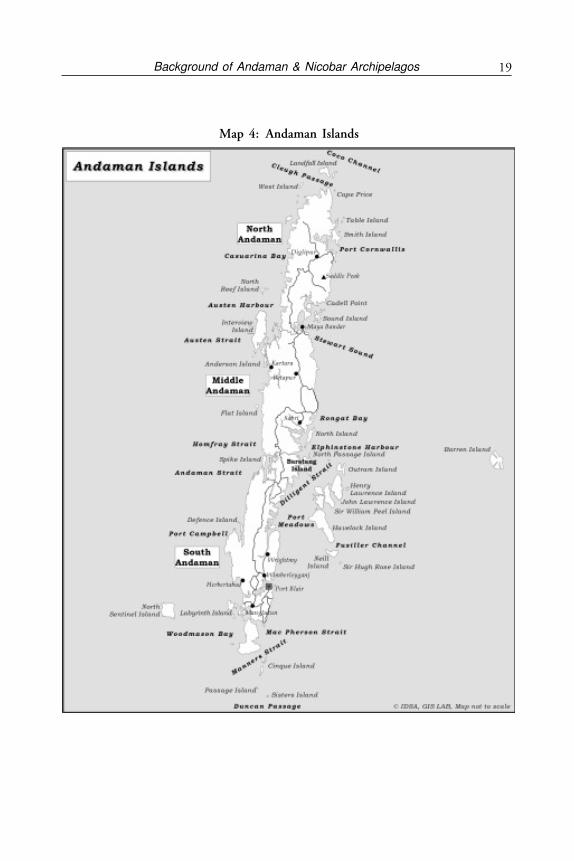
Map 4: Andaman Islands
Andaman and Nicobar Islands20
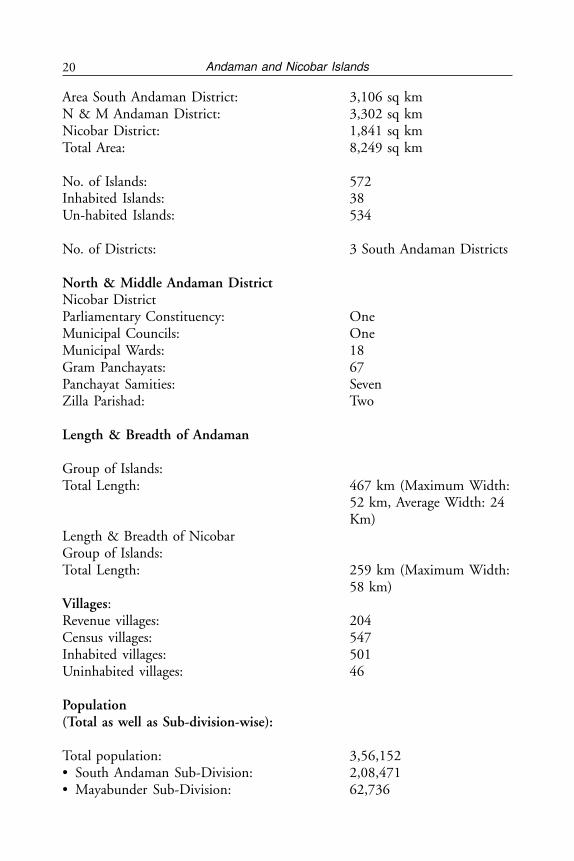
Area South Andaman District: 3,106 sq kmN & M Andaman District: 3,302 sq kmNicobar District: 1,841 sq kmTotal Area: 8,249 sq km
No. of Islands: 572Inhabited Islands: 38Un-habited Islands: 534
No. of Districts: 3 South Andaman Districts
North & Middle Andaman DistrictNicobar DistrictParliamentary Constituency: OneMunicipal Councils: OneMunicipal Wards: 18Gram Panchayats: 67Panchayat Samities: SevenZilla Parishad: Two
Length & Breadth of Andaman
Group of Islands:Total Length: 467 km (Maximum Width:
52 km, Average Width: 24Km)
Length & Breadth of NicobarGroup of Islands:Total Length: 259 km (Maximum Width:
58 km)Villages:Revenue villages: 204Census villages: 547Inhabited villages: 501Uninhabited villages: 46
Population(Total as well as Sub-division-wise):
Total population: 3,56,152• South Andaman Sub-Division: 2,08,471• Mayabunder Sub-Division: 62,736
21Background of Andaman & Nicobar Archipelagos
• Diglipur Sub-Division: 42,877• Car Nicobar Sub-Division: 20,292• Nancowry Sub-Division: 13,562• Campbell Bay Sub-Division 8,214
Literacy rate of males and females(Total as well as sub-division wise):• South Andaman District: 1,55,403• North & Middle Andaman District: 71,197• Nicobar District: 26,535• Total Male Literates: 1,46,831• Total Female Literates: 1,06,304
Police StationsPolice stations are spread all over the inhabited islands. The crime rate is negligible.
BACKGROUND OF ANDAMAN ISLANDS
Mythologically, the name Andaman is presumed to be derived from Hanuman,the monkey God, who was known to the Malays as Handuman. Since pre-historictimes, these islands were the home of aboriginal tribes. The tribes of the Andamangroup of islands are the Great Andamanese, Onges, Jarawas and Sentinelese, allof Negrito origin, while the tribes of Nicobars are the Nicobarese and Shompens,both of Mongoloid stock.
The first settlement on the islands by the British took place in 1789, whichwas abandoned in 1796. The second settlement which was basically a penalsettlement was taken up in 1858, after the first War of Independence in 1857,followed by the settlement of convicts including Moplas, some tribes fromCentral and United Provinces, refugees from erstwhile East Pakistan, Myanmarand Sri Lanka as well as ex-servicemen. The islands become known in India as“Kala Pani” or black waters due to the penal settlement and its terrible livingconditions.1
These islands, blessed with natural beauty, 86 per cent forest cover, beaches,undulating creeks, crystal clear water with corals and unpolluted environmentcommand the first place to visit for tourists. This archipelago of more than 572islets and islands with 37 inhabited islands stretches over a length of more than700 km from North to South. The topography of the islands is hilly with exoticflora and fauna. The sandy beaches, fringed with coconut palms, and the seaaround the island offer excellent scope for adventure water sports including scubadiving and game-fishing. These green islands could attract many nature-lovers,and bird-watchers from all over the world. Adventure tourism like trekking, islandcamping, snorkeling, scuba diving etc. can become the major attractions here.
Andaman and Nicobar Islands22
Location Bay of Bengal
92º to 94º East Longitude
6º to 14º North Latitude
Capital Port Blair
Highest Peak-Saddle Peak – 732 mtrs
Climate
Tropical and humid, humidity ranges from 70 per cent to 90 per cent with agentle breeze blowing at all times. The weather is generally pleasant with a meanminimum temperature of 23ºC and mean maximum of 30ºC.
Access
By Air: Port Blair, the capital city of Andaman & Nicobar Islands is poorlyconnected with direct flights from only Chennai, Kolkata and Delhi (viaBhubaneshwar) in India. Foreign tourist charter flights are also permitted toland at Port Blair subject to the fulfilment of guidelines of the Director Generalof Civil Aviation (DGCA). A few islands are also interconnected by helicoptersoperated by Pawan Hans. However, not many seats are available in these smallhelicopters. There is a differential tariff structure, one for islanders which issubsidised and the other for the rest. Recently a sea plane has been introducedto a limited number of destinations.
Port Blair is 1,200 km from mainland India (Chennai or Kolkata). Airconnectivity is limited and expensive and is two hours by jet aircraft from eitherplace. There is very little connectivity within the islands in spite of four airstripsavailable from Diglipur in the north Andamans to Campbell Bay in the GreatNicobar Islands in the south. Only recently a passenger helicopter service hasstarted with very limited capacity. While Andaman is within the DirectorateGeneral of Civil Aviation (DGCA) Group Disbursal Guidelines which forcesairlines to connect to North-East, J&K and Andamans, the services are notadequate and only Port Blair is being touched in spite of Car Nicobar providingan excellent airport. Earlier Indian Airlines used to have a weekly service fromKolkata, Port Blair, Car Nicobar, Chennai. This is no more there. Further dueto free pricing, air tickets can be prohibitive during seasons.
By Sea: Regular passenger ship services are available to Port Blair from Chennai,Kolkata and Vishakhapatnam. There are three to four sailings for Kolkata andChennai and one sailing for Vishakhapatnam every month.
Chennai – Port Blair: Journey time about 60 hrs.Kolkata – Port Blair: Journey time about 66 hrs.Vishakhapatnam - Port Blair: Journey time about 56 hrs.
23Background of Andaman & Nicobar Archipelagos
Map
5:
Con
nec
tivi
ty t
o A
nd
aman
& N
icob
ar I
slan
ds
Andaman and Nicobar Islands24
SOME FEATURES OF PORT BLAIR
Cellular Jail: National Memorial
The Cellular Jail constructed by the British in 1906, located at Port Blair, standsmute witness to the atrocities meted out to the freedom fighters, who wereincarcerated in this jail. The name ‘Cellular’ was given as this jail is made up ofindividual cells for solitary confinement of the prisoners. Originally, it was aseven pronged building with the central tower acting as its fulcrum and a massivestructure comprising honey comb like corridors. This jail has been declared a‘National Memorial’.
Ross Island
Once the seat of British power and capital of these islands where theCommissioner resided, it stands now as a ruin of the bygone days with the oldstructures almost in debris but held tighter by roots of trees which havesurrounded it. A small museum named ‘Smritika’ holds photographs and otherantiques of the British relevant to these islands. It is an important place of touristinterest.
Viper Island
Notorious for chain gang punishment, this island was used as an open jail forthe convicts as well as freedom fighters by the Britishers prior to construction ofthe Cellular Jail. The jail at Viper Island was abandoned after the constructionof Cellular Jail. It has a gallows atop a hillock, where condemned prisoners werehanged. Viper Island also saw assassination of Lord Mayo, the Viceroy of Indiain 1872, by Sher Ali, who was also hanged here.
Chatham Saw Mill
The Chatham Saw Mill, one of the oldest and the largest Saw Mills in Asia, isbuilt on a tiny island named Chatham and is connected to the main island bya bridge. It is a storehouse of timber like Padauk, Gurjan, Marble, Satin Wood,etc. This island has the second largest wharf of these islands and is near theHaddo Wharf.
Mount Harriet
Once the summer Head Quarters of the erstwhile Chief Commissioners duringthe British Raj, this place is ideal for a fascinating distant view of the otherislands and the sea. It is the highest peak in the South Andamans (365 metreshigh). One can trek up to Madhuban through a nature trail and can find rareendemic birds, animals and butterflies. Conducted tours to Mt. Harriet areavailable from Andaman Teal House.
25Background of Andaman & Nicobar Archipelagos
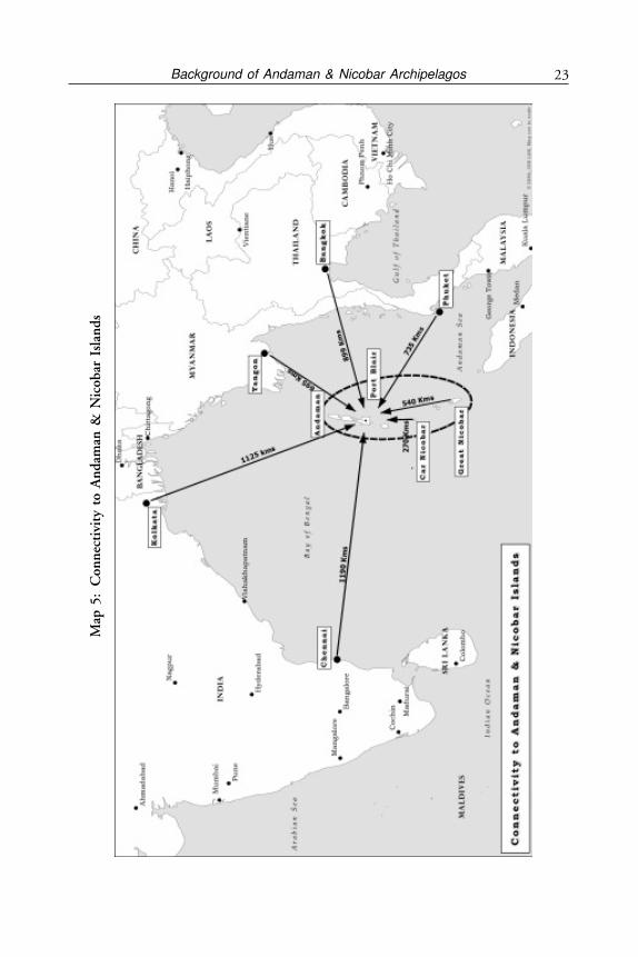
Distances from Port Blair
• 1,255 km from Kolkata to Port Blair• 1,190 km from Chennai to Port Blair• 1,200 km from Vishakhapatnam to Port Blair• 735 km from Phuket to Port Blair• 899 km from Bangkok to Port Blair• 1,687 km from Singapore to Port Blair• 695 km from Yangon to Port Blair• 1,843 km from Malacca to Port Blair
Other islands of the Andaman group are poorly connected but the Nicobar ismuch worse. The main islands of the Andaman Group from Port Blair to Diglipurin the north are connected by a road which is the only highway in the Andamansbut is under orders of the Supreme Court to be closed due to the fact that itpasses through the territory of Jarawas, a primitive tribe under protection ofTribal Regulation Act.
The potential wealth of these islands and EEZ has not been determined.However, if oil can be found offshore between Nicobar and Sumatra, there is noreason why the Nicobars should not have it. It has also been recorded that thesea around Andaman & Nicobar Islands is part of one of the four areas of theworld that contain extensive deposits of magnesium nodules.2
THE ANDAMAN STORY
The Settlements
Prior to the 18th Century the Andaman Islands were not colonised unlike theNicobars where the Danes started settlement but failed. In Andamans prior tothe British, certain primitive tribes like the Andamans, Jarawas dominated theseSouth Andaman Islands while Onges, another primitive tribe lived in LittleAndaman Island. Yet another primitive tribe lived and continues to live in SentinelIslands and is known as Sentinelese. They are still hostile to other human beings.
It was in the 19th Century that the British Government of India decided touse Port Blair as a Penal Settlement for its convicts. This started the inhabitationof these islands. Over time the now famous Cellular Jail was built between 1896and 1906 and the convicts who completed their sentence were allowed to stayback and were allotted agricultural land. The government allotted agriculturalland to the convicts under Section 5 of A & N Regulation, 1926. The convictscame from all parts of India and as they settled they started to intermarry acrossreligious and linguistic groups due to shortage of marriageable couples, especiallyfemales. This led to growth of a composite culture and Hindi became the linguafranca. Later Indian freedom fighters were also incarcerated here. Thereafter, therewere many waves of settlements in these islands. The Bengalis of erstwhile East
Andaman and Nicobar Islands26
Pakistan came after independence and were settled in islands around Port Blair.The Bhantaus of Uttar Pradesh, a community engaged in robbery and dacoity,were sent by the British, Myanmarese who revolted against the British were sentto these islands, and Karens of Myanmar were also brought in by the British.The Moplahs of Kerala were deported after the Moplah rebellion in 1921. Thenpost-independence there was natural migration in search of better living by Tamils,Malayalis the Telugu people and people of Ranchi.
The penal settlement was abolished in 1945 when the British re-took theislands from the Japanese and gave free pardon to all the convicts. They wereoffered repatriation to mainland India but most settled in the Andamans.3
During the Japanese occupation from 1942-45, the islands were renamedShaheed & Swaraj Deep Islands. A provisional government under the IndianNational Army (INA) with Subhash Chandra Bose as its head was made in chargenominally while the Japanese military commanders ruled over the islands. GeneralLoganathan of the INA was appointed Governor. Since the Japanese were opposedto the British in World War II, they allowed Subhash Chandra Bose to raise theIndian flag at Port Blair on December 30, 1943. Hence, while India attainedindependence on August 15, 1947, the Andaman Islands had already raised theIndian flag in 1943.
Post-independence as there was a feeling in some sectors of government thatthese islands are very isolated from mainland India and very insecure, a strategyto settle ex-servicemen was made by the Central Government. About 300 familiesof ex-servicemen were settled with land in the Great Nicobar Island with a viewthat they will provide the necessary intelligence against any untoward happenings.The ex-servicemen were settled along the coast from Campbell Bay to IndiraPoint (earlier known as Pygmalion Point).The resettlement of ex-servicemen inthe Great Nicobar Island was carried out in a systematic manner by the Ministryof Rehabilitation, Government of India in coordination with Director GeneralResettlement (DGR) of the army. Each soldier was provided with free land andcattle and a resettlement organisation was set up with a ResettlementCommissioner in Port Blair working under the Chief Commissioner (Nowelevated to Lt. Governor) with his officers in Campbell Bay.
The main aspect of this resettlement was strategic. By putting ex-servicemenin Great Nicobar it was felt India would create a small group of well trainedIndians who would be able to provide the initial intelligence to any undesirableactivity in that area. The only other residents of Great Nicobar Island are a smallgroup of Nicobarese tribals who were so isolated and backward that they werenot considered a strategic asset. Another group of tribals, very primitive are theShompens, whose number is in a couple of thousands if not hundreds. Whilethey are friendly, they are shy and unable to communicate. Therefore, was putting300 families of ex-servicemen a good decision in 1970? Yes, when there were few
27Background of Andaman & Nicobar Archipelagos
alternatives and government budgetary resources were very poor this alternativewas perhaps, the best. This settlement so far away had its own problems. In 1975the ex-servicemen even went on strike for their demands. The issues were thensorted out.
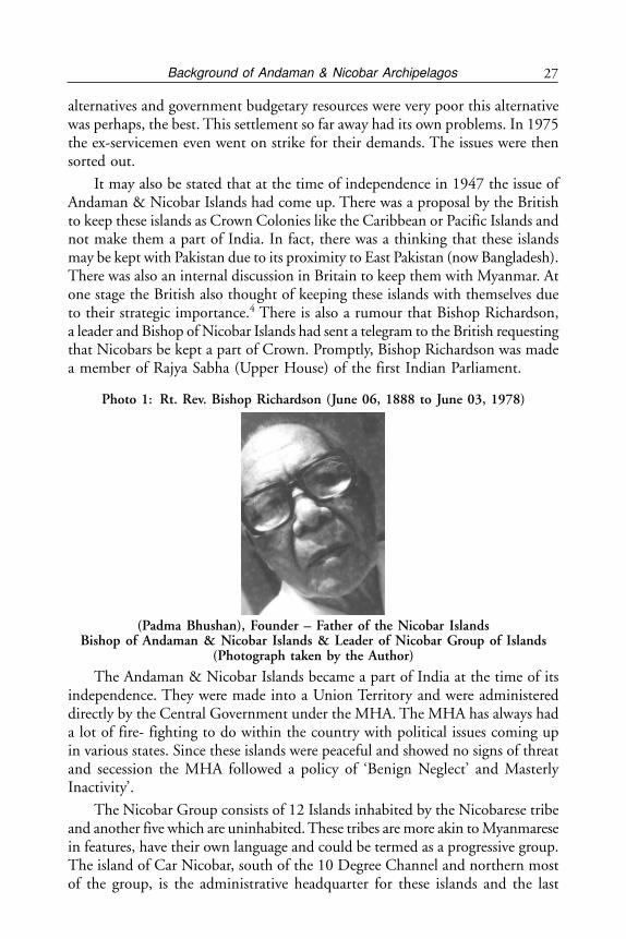
It may also be stated that at the time of independence in 1947 the issue ofAndaman & Nicobar Islands had come up. There was a proposal by the Britishto keep these islands as Crown Colonies like the Caribbean or Pacific Islands andnot make them a part of India. In fact, there was a thinking that these islandsmay be kept with Pakistan due to its proximity to East Pakistan (now Bangladesh).There was also an internal discussion in Britain to keep them with Myanmar. Atone stage the British also thought of keeping these islands with themselves dueto their strategic importance.4 There is also a rumour that Bishop Richardson,a leader and Bishop of Nicobar Islands had sent a telegram to the British requestingthat Nicobars be kept a part of Crown. Promptly, Bishop Richardson was madea member of Rajya Sabha (Upper House) of the first Indian Parliament.
Photo 1: Rt. Rev. Bishop Richardson (June 06, 1888 to June 03, 1978)
(Padma Bhushan), Founder – Father of the Nicobar IslandsBishop of Andaman & Nicobar Islands & Leader of Nicobar Group of Islands
(Photograph taken by the Author)
The Andaman & Nicobar Islands became a part of India at the time of itsindependence. They were made into a Union Territory and were administereddirectly by the Central Government under the MHA. The MHA has always hada lot of fire- fighting to do within the country with political issues coming upin various states. Since these islands were peaceful and showed no signs of threatand secession the MHA followed a policy of ‘Benign Neglect’ and MasterlyInactivity’.
The Nicobar Group consists of 12 Islands inhabited by the Nicobarese tribeand another five which are uninhabited. These tribes are more akin to Myanmaresein features, have their own language and could be termed as a progressive group.The island of Car Nicobar, south of the 10 Degree Channel and northern mostof the group, is the administrative headquarter for these islands and the last
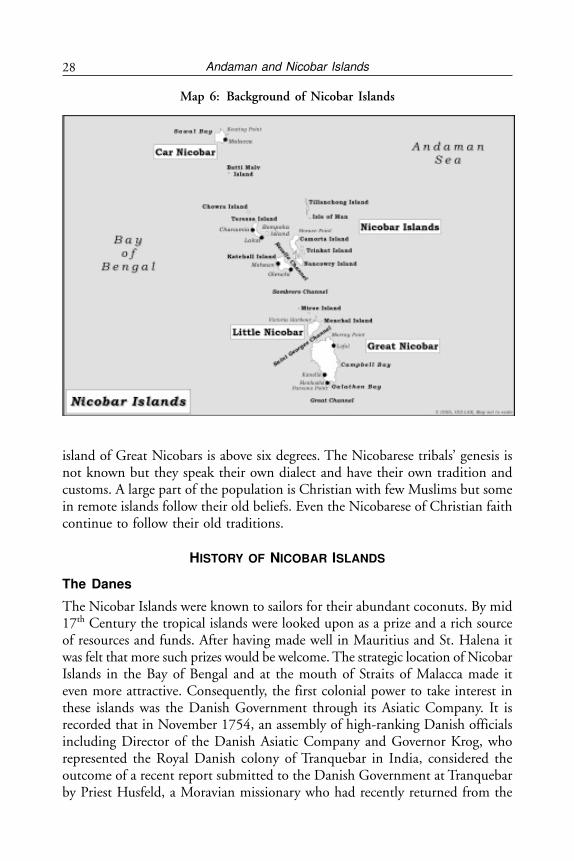
Andaman and Nicobar Islands28
island of Great Nicobars is above six degrees. The Nicobarese tribals’ genesis isnot known but they speak their own dialect and have their own tradition andcustoms. A large part of the population is Christian with few Muslims but somein remote islands follow their old beliefs. Even the Nicobarese of Christian faithcontinue to follow their old traditions.
HISTORY OF NICOBAR ISLANDS
The Danes
The Nicobar Islands were known to sailors for their abundant coconuts. By mid17th Century the tropical islands were looked upon as a prize and a rich sourceof resources and funds. After having made well in Mauritius and St. Halena itwas felt that more such prizes would be welcome. The strategic location of NicobarIslands in the Bay of Bengal and at the mouth of Straits of Malacca made iteven more attractive. Consequently, the first colonial power to take interest inthese islands was the Danish Government through its Asiatic Company. It isrecorded that in November 1754, an assembly of high-ranking Danish officialsincluding Director of the Danish Asiatic Company and Governor Krog, whorepresented the Royal Danish colony of Tranquebar in India, considered theoutcome of a recent report submitted to the Danish Government at Tranquebarby Priest Husfeld, a Moravian missionary who had recently returned from the
Map 6: Background of Nicobar Islands
29Background of Andaman & Nicobar Archipelagos
Nicobar Islands. The report described the Nicobars as an excellent place forplanting pepper, cinnamon, sugarcane, coffee and cotton. Further, besides theirlocal resources of coconuts and areca nuts, the islands were said to be locatedsuitably to become a centre for Indian trade and the ship-building industry dueto their abundant timber resources.
The Danish Moravian Missionaries tried settlements in the Nicobar Islandsfour times in different islands over the period 1755 to 1851 but failed everytime. The reason for their failure is not clear, but it appears from all evidence thatthey could not get over the climatic conditions and malaria fever which some ofthem contracted and the support from their government was also poor. However,the remnants of their stay are hardly there except for wild cows found in CarNicobar, Nancowry and some other islands. Since the Nicobarese do notdomesticate these cows, nor do they drink cow’s milk or eat their meat, they havebeen allowed to go wild and have multiplied over the years. The second evidenceof their stay is the fencing used by the local people. Nicobarese keep a lot of pigs.Some are domesticated and some wild. In both cases the pigs are found all overthe islands. Since Nicobarese are also settled agriculturalists and plant maize andother crops besides coconuts, they need to protect their fields from their pigswhich are allowed to roam around free. For this they have a special type of fencingfor the agricultural plots which they consider to be pig proof. This fencing is acrisscross made of small wooden sticks in the design and is strong enough towithstand a pig’s attempts to enter it. According to Bishop Richardson, this fencingwas introduced by the Danish Moravian Missionaries. Besides these twoindications there is no particular evidence that the Danish were in Nicobars.
The term “Danish period” broadly refers to the colonial period when theDanes theoretically were the European “owners” of the Nicobar Islands. However,during this period, the islands were occupied technically briefly by the Austro-Hungarians from 1778 to 1783, and later by the British from 1807 to 1814, thetime when Denmark and Britain were at war with each other. Neither the Austriansnor the British undertook any substantial activities on the Nicobars during theirperiod of occupation. The Danish declared these islands as their property onJanuary 1, 1756, and they were re-named “New Denmark”. They remainednominally Danish till the British took over in 1851.
As already brought out, the Moravian Missionaries, however, could notmaintain the colony by themselves. The problem was the climate and diseaseslike malaria which caused many deaths. In a period of less than 20 years, it wasreported that of the 25 missionaries who had arrived on the Nicobars, 11 haddied on the islands while another 13 died after returning to Tranquebar on theIndian mainland.5 The situation became even more difficult for them when theonly ship they had possessed in the preceding years was stolen by a pirate. Themissionaries moved from one island to another over time. Originally they set
Andaman and Nicobar Islands30
themselves up in Nancowry-Kamorta but tried out Teressa, Bambooka and CarNicobar Islands.
A number of attempts were made to establish a settlement but all failed. Atone time on return of the missionaries eight soldiers were sent to keep the flagflying. A new plan was formulated to make better use of the islands. The DanishGovernment in Copenhagen offered four years’ of help—in the form of supplies—to those who would voluntarily go to the Nicobars as part of the Danishestablishment. By now, aware of the death-trap, the offer was received withoutany enthusiasm in Tranquebar and nothing came of it.
Two scientific expeditions were mounted by the Danes in 1755 and later in1768 at a heavy expenditure to the government. The investments on the Nicobarsseemed unprofitable in the short term at least. Consequently, the Danish companystarted to withdraw from these activities and the Danish Government started totake over their activities. At the same time, by the mid-1770s, the Company’sactivities in general declined at Tranquebar in the Coromandel Coast of India ascompared to the trade in Bengal. In 1777, the crown’s decision to take over allthe colonies in India, among them the Nicobars, relieved the Company of afinancial burden, and it was left to concentrate on trade, in particular with China.
The British Period: The Trading World of the Nicobars 1851-47(except for the Japanese Occupation 1942-45)
The Danish Missionaries left the Nicobars in 1851 and the British took over.The idea of setting up a penal settlement by the British came in late 18th Century.In 1869 the British formally took over the Nicobar group of islands withpermission of the Danish Authorities who had nominal control over them. Itwas also felt that Nancowry-Kamorta harbour, which is one of the finest naturalharbours in the world, could be developed into a penal colony in addition tothe one already existing at Port Blair in the Andamans. The penal settlement atNancowry was developed by the British Government and lasted from 1869 to1888, a period of 19 years. The convict labour were used for construction of thesettlement, planting of vegetables, production of coconut oil, fruits pineapples,yams, mangoes etc. However, it was closed down in favour of Port Blair in theAndamans.
Even after closure of the Nancowry penal settlement the British continuedtheir hold over the Nicobar Islands. By 1897 the British appointed Rev. Solomon,a missionary in Car Nicobar as Government Agent. A school was established bythe Anglican Mission in 1896. With the establishment of an Agent and a schoolin Car Nicobar by 1900 Nicobar was well established as a British territory. By1918 an Assistant Commissioner post was established in Car Nicobar followedby a post of Tahsildar in Nancowry. The first British officer to be posted as Agentwas Mr. Hart in 1918 followed by Bishop Richardson, a famous local tribal, as
31Background of Andaman & Nicobar Archipelagos
an interim arrangement for a year. This was followed by another British officerMr Scott in 1929. Mr. Scott continued for many years till 1942 when the Japanesetook over these islands and again came back after they left. His personal popularityamongst the tribals was very high.
The British period, as we will see, was far more dynamic than the precedingDanish one. This was so because the British posted or designated their nationalsin positions of administrative power. Starting with 1869 in Nancowry the Britishadministration had much more success in establishing a system of control andenforcing regulations throughout the islands. The penal settlement establishedin 1869 lasted for 19 years till 1888. This supplemented the one existing in PortBlair at Andaman Islands. One can say that the British actually governed theseislands, and in this sense, for the first time the Nicobars were incorporated intoa system of statehood. The occupation of the Nicobarese tribals also had a directconnection with trade as they supplied the coconuts for export-the main produceof these islands.
The occasional acts of piracy in these waters were a matter of concern to theBritish who decided to bring greater control over these waters. In order to bringgreater order to the region the British decided to tighten the administration furtherby regulating trade and stay in the islands. This they achieved by setting up apermanent administration over these islands. It was customary for vessels sailingto Rangoon (now Yangon) from the Straits of Malacca to visit the Nicobars fora cargo of coconuts which the traders bartered at most advantageous rates forgoods and rum. Trade picked up once the British established a Penal Settlementat Nancowry and maintained a close surveillance on the trading activities in theregion. In only a short time, it was discovered that most of the cases of violenceor so-called piracy were the result of provocation on the part of the traders.Stringent laws were established to ensure a certain level of control over the traders,“some of whom have habitually acted in an over-bearing manner towards theNicobarese, as if imagining themselves to be well-nigh beyond the reach of law”.
Regulation of 1882—Permission to Reside in Nancowry Penal Settlement
by Traders
Introduction of copra making technology was a game changer. Instead of onlyexport of coconut the British found it practical to allow traders to set up andstay in Nancowry Settlement Area as copra making required a longer stay. Thistechnology shift was mainly due to the Nicobar Trading Company Limited basedat Penang who also obtained permission to reside and trade at Nancowry. Thisshift in trading practice took place as it was found that coconut meat scoopedfrom the shell and dried (called copra) could be exported instead of coconut oilthereby saving on transportation costs. On arrival, the oil could be extracted inEurope for use in many industrial products, while the residue served as valuablecattle feed. This innovation laid the foundations for the copra industry in the
Andaman and Nicobar Islands32
Nicobars. The tropical climate of the Nicobars allowed copra production onlyduring the dry period of the northeast winds when sunshine was abundant. Atfirst, copra comprised only a small part of the exported cargo in relation tococonuts. Over time, this pattern changed and most of the coconuts bartered inthe Nicobars began to be converted to copra. Furthermore, the Nicobars weregaining prominence as an important source for coconuts which induced thetraders to establish semi-permanent bases on the islands. Residing on the islandshad its own advantages: a good rapport with the Nicobarese and favourablenegotiating conditions, in which the traders invariably had the upper hand.
By 1882, the British authorities introduced better control over these tradersmaking it possible. From 1889 the agents at Car Nicobar and Nancowry wouldmake five to six visits each year followed by officers of the British administrationstationed at Port Blair. During these visits, the administration invariably finedthose vessels that were caught trading without a permit or were engaged in anyform of illicit trade. It was the objective of the British administration to fostertrade in the islands, yet keep control over it. The success of the policy was seenby the growth of trade that took place through this control mechanism. Thismechanism was also appreciated by traders as safety of trade also improved. Italso brought in some revenue to the British.
By 1883 it was made mandatory for traders to acquire a trading permit onpayment thereby permitting them to trade in the islands. This permit could bebought either at Nancowry (and later at Car Nicobar as well) or at Port Blair andhad to be renewed annually. Every vessel, before its departure from the islands,was expected to obtain a port clearance from the local officer or agent and todeclare the quantity of goods being exported. A register was maintained to ensurecontrol, and to keep a record of the traders and their activities in the islands.This again brought better order and more revenue to the British.
The Nicobarese were friendly but reserved. They were also not keen thattraders should settle in the Islands. The Nicobarese of Car Nicobar were forsome years opposed to traders establishing their shops and houses in the villages.Traders had been customarily restricted to the Elpanam (community space at thebeach) where they could live and trade, and at the end of the season, were expectedto leave. However, this changed in the late 1890s with the arrival of Rev. Solomonas catechist and agent who, through his influence over the Nicobarese, gainedallowance for the traders to establish shops and houses in the villages and livethere for as long as they desired.
Mr. A. de Roepstorff was a British officer posted at the Nancowry PenalSettlement for some years until he was murdered by some convicts in October1883. Roepstorff holds the distinction of being the first to carry out a near-systematic population survey of the Nicobar Islands in 1883, shortly before hisdeath.
33Background of Andaman & Nicobar Archipelagos
Over time, Car Nicobar became the most important island. Most of theresident traders on these islands came to concentrate on the island of Car Nicobarbecause of its high density of coconut plantation. Traders came from all aroundand their profile kept changing. Around 1900, the majority of the traders residingon the islands were from Myanmar while a small number of them came fromLaccadives, China, Maldives and the Indian sub-continent. Of the 201 tradersin 1901, 154 were Buddhists, 32 Muslims, four were Hindus, and 11 wereChristians. However, by the 1920s, the Myanmarese population of traders haddecreased from 75 per cent to 25 per cent of the trader’s resident on the island.The majority were then a mix of traders from the Maldives, Laccadives, Ceylonand Madras. On average, there was one trader to every 30 inhabitants, withseveral competing shops in each village. Most of these shops did not function asindependent enterprises but were actually “collecting stations” of bigger firmsbased in India or Myanmar. The more prosperous were the Indian shops thathad their company headquarters in Calcutta, Bombay or Colombo. Theytransported their produce in chartered vessels whereas the Myanmarese firmswere much smaller and freighted their goods on boats of other firms. The goodsthat these shops sold were rice, Chinese tobacco, a variety of cloth and clothes,cutting tools such as choppers (dahs) and axes, soup-ladles, table-spoons, forks,cups, tumblers, enameled soup-plates, salt and sugar, condensed milk, coarsebiscuits, matches, kerosene oil and many such items. A decade later, the Muslimtraders from the island of Minicoy in the Laccadives came to be the dominantgroup among all. According to the survey in 1931, of the 3,632 Nicobarese onCar Nicobar, 559 could converse in Hindi and 157 of them Myanmarese. Thesituation in the central and southern islands was different. These had moreinteraction with Malays and hence of the 2,531 Nicobarese there, 793 spokeMalay.
There was a lot of traditional festivity amongst the tribals. Roepstorff hasshown that most of the goods the Nicobarese imported were “wasted” in feastsand rituals. Roepstorff exemplified his argument by a series of calculations onimports and exports. He began by listing out the needs of the Nicobarese andthen multiplying them by population. He calculated that a population of 5,500Nicobarese would need to export the following number of coconuts annually tomeet their requirements for commodities considered most essential, that is, iron,cloth, tobacco and rice. Of course, his biased value judgment was not acceptableto the tribals.
However, calculations and recorded statistics revealed that the number ofcoconuts that were exported from the Nicobars in 1880-81 amounted to at leastsix million coconuts. In this sense, five million coconuts were “wasted” on buyinggoods they did not really utilise. Illustrating his point via another calculation,Roepstorff showed that most of the surplus coconuts went into buying unnecessarythings. The export statistics of 1880-81 record 5,534,546 coconuts and Roepstorff
Andaman and Nicobar Islands34
rounds this figure to six million to account for some of the unreported trade.According to him, six million coconuts was still a low estimate.
The Village Organisation in Nicobars: The villages had their own headmencalled “Captains.” The system of “captainship” was not only kept in place but,with the growing necessity of trade and foreign goods, the position became moreprivileged than before. The British administration further empowered theseheadmen or “captains” with privileges and presents to the extent that they cameto exert a certain influence not only on trade-related matters, but within thesociety as well. The Captains became the link between the Nicobarese and theoutside world, a link that increasingly became central to their lives.
1915: Export Royalty Introduced
In 1915, the British Government introduced payment of royalty for all that wasexported from the islands as a means of contribution to the cost of theadministration. The royalty initially at five per cent was later increased to 10 percent in 1919.This was accepted as it also provided for a greater organised tradeand some security. The British administration, therefore, introduced revenuegeneration by taxing the tribals.
1915-20: Abolition of Nicobarese Indebtedness to Traders
The British had an indulgent and paternalistic view of the tribals. An upsettingpart of the growth in trade was the increasing indebtedness of Nicobarese to thetraders. Nicobarese were simple, easygoing and uneducated. In their desire tobuy things available in traders’ shops they had no concept or control over theirdesire. Consequently, the traders were extracting a very high price in terms ofcoconuts and if a Nicobarese did not have sufficient number of coconuts, thetrader would take a mortgage of his future crop. The Nicobarese being simplein nature often found themselves heavily indebted to these traders. The Britishwere not able to contain the increasing indebtedness of the Nicobarese towardsthe traders. Over time, business relations between traders and the Nicobaresedeveloped on a regular basis and once formed, were rarely severed. Vessels visitedthe same islands or villages to barter coconuts as they had done in the precedingyears, and depending on the success of the last season, new vessels were attractedto the islands. In almost all the cases, bartering had been to the profit of thetraders. In 1914, a statistical survey revealed that the Nicobarese owed the traders7.5 million coconuts; a debt that would take them 10 years to settle. Rev. GeorgeWhitehead, in charge of the mission on Car Nicobar for some years, explainedhow the Nicobarese were induced into debt by the traders:
‘... The trader would invite to his shop someone whom he knew to be fairlyrich—that is, to be the owner of a tolerably large number of coco-palms—and would treat him hospitably, giving him tobacco and lemonade and otherslight presents. He would then show him goods he had which he thought
35Background of Andaman & Nicobar Archipelagos
might appeal to the man’s acquisitive proclivities—cloth and spoons fordisplay, rice and tobacco for consumption, or choppers (dahs) and plates foruse. If the Nicobarese saw anything that he would like to have, as he generallydid, the trader would urge him to take it, even though the man told himthat he had no nuts in hand, and the ones now ripening on his tree werepromised to some other trader for goods which had been received some timeago. If the Nicobarese did not come to the shop, the trader would take thegoods round to the man’s house and persuade him to take them. Occasionallyin this way a Nicobarese man or woman would somewhat lightly take aquantity of goods of the supposed value of thousand (pairs of ) nuts; whichdebt he would be paying off for many years to come. As there was noNicobarese writing, the trader would give the Nicobarese man a tally-stickon which were cut a number of notches showing how many thousands,hundreds and tens of (pairs of ) nuts the man was owing; and when he madeany payment of nuts, or bought any more goods, the tally-stick was correctedby the tradesman and returned to the Nicobarese.
The matter of debt was taken up by the administration, at which the tradersexpressed their anxiety to compromise with their Nicobarese debtors rather thanaccept official intervention. The initial focus was more on Car Nicobar thanNancowry, since the problem of indebtedness was found to be greater in theformer than the latter. Consequently, a decision was taken wherein theadministration asked the traders to settle their debts with Car Nicobar within aperiod of five years, that is, by April 1, 1920. An agreement to this effect wassigned by the traders. Credit sales ceased and in only a year, the debt fell from7.5 million to 1.7 million nuts in Car Nicobar. Efforts in this direction includedthe introduction of currency and doing away with the barter system. This,however, did not find favour with the Nicobarese, since they were not used tonor did they have any use of currency in their island.
Trader’s misbehaviour towards Nicobarese:
As the number of traders grew, reports of misbehaviour by them also grew.The British Government attitude towards Nicobarese was of benevolence,guardianship and protection. Consequently, the traders were never too happywith the administration. On the other hand the relationship between thetraders and the Nicobarese was one of constant arguments that sometimesended up in severe forms of violence. Each time a court was held on theislands on the occasion of visits by officers, some three or four so-calledcriminal cases were brought to court and the accused punished by way offines or imprisonment or both. The Annual Reports reveal that most of thecriminal cases concerned Chinese traders in dispute with the Nicobarese.On the other hand, the trade related quarrels were common to all. Therehave been cases of violence against the traders resulting in murder due totheir exploitative nature. While Nicobarese were fined in terms of coconuts,the trading license was cancelled in many cases.
Andaman and Nicobar Islands36
Bishop Richardson’s account of the Japanese occupation reflects the tradersin an extremely bad light. As soon as news of the Japanese occupation reachedCar Nicobars, the question of repayment of debt that had been cancelled by theBritish administration 25 years earlier was raised once again. The tradersapproached Richardson in December 1942 and demanded the payment of theold outstanding debt that was now illegal. They threatened to report the matterto the Japanese authorities whom everyone feared. The Nicobarese felt compelledto pay half of the outstanding amount to resolve the dispute.6 Richardson’sremarks on the traders when they were compelled to leave after the war are worthciting:
“Most of the traders found lives quite easy with good income. The averageincome each got was from Rs. 144/- to Rs. 180/- per month, including foodand clothing. Many of them got married to Nicobarese girls but would alsoabandon them and their children. Someone will marry the divorced, onceagain. In this way half castes children were born; left behind and uncaredfor. Because their religion forbids them to live with none other than theirown religion relatives they became vagabonds. Moreover, they look downon their fellow Nicobarese. During the Japanese occupation the traders wereall fed free of charge by the Nicobarese; yet they were too proud to say ‘ThankYou’ for everything received from our people; whom they compared to beasts.Well we have done our duty; expecting no reward from the ungrateful friends.We have seen rewarded evil for good. In all their lives here, they have notdone a single charitable work; but grabbing…”
1880 Regulation Prohibiting Import of Alcohol, Arms and Ammunition into
Nicobars
Another aspect of the traders’ activity was the inducement of Nicobarese menthrough liquor. While the Nicobarese were fond of liquor and they had plentyas each coconut tree would provide a mild alcoholic drink, the traders wouldinduce them by importing cheap hard liquor (arrack) and selling it at a highprice. The British administration was actively engaged in fostering trade in theislands but wanted to ensure the establishment of cordial and non-exploitativerelations between the traders and the Nicobarese. The administration wasextremely sensitive to the behaviour of the traders towards the Nicobarese intheir trade negotiations. For example, the administrators noted that the traderstook advantage of the Nicobarese addiction to liquor. Once the Nicobaresewere drunk, the traders could sell them anything at prices they dictated.Consequently, in November 1880, the administration passed a Regulationprohibiting the import of alcohol, arms and ammunition to the Nicobarswithout a license.
37Background of Andaman & Nicobar Archipelagos
The Story of R. Akoojee Jadwet & Company
One of the companies that frequently traded with these islands since the turn ofthe last century was R. Akoojee Jadwet & Company, a partnership firm betweentwo Gujarati families, the Akoojee and the Jadwets. We do not know when thecompany was first established, but by the early 1900s, the company had theirheadquarters in Moulmein (Myanmar) and ran a flourishing trade betweenGujarat and Myanmar. Their vessels regularly frequented the Nicobar Islands toobtain a cargo of coconuts and areca nuts to be sold in Myanmar. The influenceof the company in the coconut trade can be gauged from the fact that they werethe only successful enterprise among several competitors to obtain a 30-year leaseover the produce of Great and Little Coco islands of the Andaman group ofislands from the British Government in the early 1930s. Akoojee Jadwet & Co.had apparently established good relations with Edward Kutchat, chief captainof Car Nicobar Island and the tribals of Nicobar who considered their tradepractices fair.7
The Interregnum: The Japanese Occupation 1942-45: The Dark Years
The Japanese occupied the Andaman & Nicobar islands during World War IIfor three and a half years from 1942 to 45. This was a dark period for the islandersas they suffered heavy, brutal treatment and shortages. They took over all theislands without resistance or firing of a single bullet on March 23, 1942 as theBritish gave up because of their meagre force. Besides the usual difficulties ofwar time the Japanese were harsh, unsympathetic and highly suspicious of anyonewho spoke English. A few Nicobarese of Car Nicobar had good knowledge ofEnglish and therefore, the Japanese considered them as British spies. Besidesthis they abused Nicobarese labour in Nicobar and took them to Port Blair tobuild huge infrastructure. Two airports at Car Nicobar and one in Port Blairwere built mainly by Nicobarese labour. The islands were fortified by cementbunkers and canons. A lot of roads, ports and other war related infrastructurewere developed in these three and a half years. The misuse and killing ofNicobarese by the Japanese had put tremendous pressure on the people of Nicobar.The Japanese left a huge stockpile of trucks, weapons, aircrafts and ships whenthey suddenly left the islands after their defeat in the Second World War.
As already stated the role of the traders at Car Nicobar was most odd. Onarrival of the Japanese they greeted them with the hope that since the BritishAdministration had been harsh with them they would get sympathy and ‘justice’from the Japanese. As war had made travel impossible for many and they couldnot go back to their homes, they continued to live in the Nicobars but they hadnothing to sell and their business had collapsed. As a result they approached theNicobarese for revival of their dues which were cancelled in 1920 by a BritishGovernment order. They threatened to complain to the Japanese. The Nicobareseheld a council and decided to review their so called debt in a settlement by giving
Andaman and Nicobar Islands38
them half their dues. On top of this the Nicobarese also arranged to feed themduring the occupation. The behaviour of the traders had totally antagonised theNicobarese. However, the Japanese killed many and only a few managed to fleethe islands. According to Richardson, “that was the only benefit we got out ofthe war”.
The Japanese interest in the islands was known for several years even beforethe war. Since the 1930s, it is reported that the Japanese had already done adetailed survey of the islands and its inhabitants through a Japanese resident ofthese islands. As World War II kept the British busy in other parts of the world,Japan which had declared war on England at the end of 1941, found it expedientto take over these island without any resistance. With the fall of Singapore in1942 followed by the occupation of the Philippines, Borneo, Sumatra, Java,Malaya and Myanmar by the Japanese forces, taking over these islands was naturaland after losses in Myanmar they wanted to prepare Andaman and Nicobars foran aerial assault on India.8 With hardly any forces of the British in the islandsit was a cake walk and the British officers actually abandoned these islands.Immediately thereafter, a Japanese administration was set up with the armycommander assuming the position of governor of the civilian population.
The Japanese had a grand plan for these islands as they realised its strategicsignificance. With the tip of Great Nicobar controlling the Straits of Malaccaand isolation of these islands in the Bay of Bengal, the Japanese were quick torealise its potential from both maritime and aviation aspects. Even the localpopulation was favourably inclined towards them initially but not after they startedusing the local population for their labour requirements and treating them veryharshly. They fortified all the islands with cement bunkers and canons, startedJapanese schools for children and wanted the islands to become self-sufficient infood. The Government High School originally run by the British was re-openedand an additional Japanese school was opened as well. In the course of their threeand a half years on these islands the Japanese fortified them, built one airstrip inPort Blair, two in Car Nicobar and placed many ships and aircrafts in the variousislands, especially in Port Blair and Car Nicobar for an attack on India.
However, there was retaliation by the British later. Ships bringing in supplieswere becoming the target of British air-raids and were being sunk just as theyentered the harbour. By 1944, the Allied forces had sunk more than 750commercial ships. Fearing that the news of vessels arriving into the harbour mustbe given out by the islanders themselves, the Japanese became suspicious of anyonewho spoke English. Several such persons were tortured and put to death. Whenthe food situation further worsened in June 1945, the Japanese “dealt” with thecrisis with a massacre of hundreds of local people, either rounding them up andthrowing them into the sea, or shooting them in the forests.9 More than a thousandpeople had to die in this way before the news of the Japanese surrender reachedthe islands on August 15, 1945. The re-occupation forces arrived on October 7,
39Background of Andaman & Nicobar Archipelagos
1945 and the islands changed hands once again without the firing of a singlebullet. The actual proclamation to the public was made by the Governor only onAugust 21, 1945.
The situation in the Nicobars had been no different. Before the Japanesearrived at Port Blair in March 1942, the British administration, in late February1942, sent a small vessel to Car Nicobar to evacuate the Assistant Commissioner,Mr. Scott, and the wireless operator, Mr. Ghosh. Four months later, on July 4,the Japanese arrived at Car Nicobar and surveyed the island for any weapons orhidden English troops. Satisfied that there were none, they returned the sameday, after installing a post with an inscription in Japanese to mark the day of theoccupation of the island. Again, at the end of the year, on December 24, theJapanese arrived at Car Nicobar and took with them 500 Nicobarese as labourerswho were needed for building the airstrip at Port Blair. Three months later, inMarch 1943, again 500 labourers were taken away for work at Port Blair witha promise to return the first batch upon the completion of a six-month stay. Atthe same time, Car Nicobar was surveyed as a possible base to be used during anattack on India.
Apparently, the impact of war in the Nicobars was mainly limited to CarNicobar which included aerial bombings while Nancowry and other islands wereaffected to a much smaller extent.
The key source of information on events that took place at Car Nicobarduring the Japanese occupation is the unpublished manuscript of John Richardson,a former student of Solomon and by then a key figure among the Nicobarese.Writing in 1947, Richardson provides a vivid description of the wartime situationon Car Nicobar and of the atrocities committed by the Japanese as he saw andexperienced them.
The name of Richardson was eventually placed on top of the list for execution.When he was to be taken away, however, one headman warned the officer, “Ifyou kill him there will be general rising on the island.” The plan was dropped,but interrogations continued. Finally, the Japanese decided to get rid of Richardsonbut just at that time the news of their surrender arrived and Richardson escapedthe death penalty. The General in charge told him:
“This is good news to you. Our Emperor is a lover of peace. He has stoppedthe war by his own effort, for he cannot bear to see any more sufferings togo on in the world. We can carry on the war for another one hundred yearsmore. As you see here our weapons are all intact. But the sole wishes of ourEmperor are peace.”10
To mend their reputation, the Japanese offered the Nicobarese compensationfor the losses of their trees and poultry. The account that was settled was for120,000 coconut trees, 5,000 pigs, 305,363 coconuts, 18,610 bananas, 2,491
Andaman and Nicobar Islands40
chickens, and 1,535 cattle. Richardson writes that the account settled was farbelow the actual damage, since the Nicobarese had stopped keeping account oflosses after a while. The loss of life was much mourned, as it amounted to 105Nicobarese, all of them educated. Of these, 90 were killed on Car Nicobar alone,while 12 were killed at Port Blair, two at Teressa, and one at Nancowry.
The Return of the British
On October, 1945, the British re-occupation forces landed at Car Nicobar.Among them was Mr. Scott, the former Assistant Commissioner who now tookup the position of Deputy Commissioner. Mr. Scott’s landing on Car Nicobarwas accompanied by deep emotions as described by Richardson:
“Mr. R.W. Scott stepped out and walked on the jetty. He made straight forme; for a few seconds no word could be uttered by either of us; instead tearswere rolling down. There was joy for being liberated; mingled with the deepsorrow for those no longer with us... Here I could find a friend in need anddeed in the person of Mr. Scott, the lost friend whom I did not expect tosee alive on this world of woe. To him I could now freely open my ear, forI knew he understood us thoroughly well and could also feel sympathy forus. He was hated by the traders for being in their way. I could feel myselfon my feet again.”
The return of the British and the last minute stopping of the execution of BishopRichardson by the Japanese had a profound impact on all. The Nicobarese realisedthe statesmanship of Bishop Richardson and he became their true leader. Notmany Nicobarese had converted to Christianity but after the Japanese departurenearly the whole island of Car Nicobar became Christian and Christianity alsospread to other islands. Secondly, the hatred for the traders intensified.
Post War in February 1946, 10 Nicobarese (six from Car Nicobar includingRichardson, and four from Nancowry) were taken to Singapore as witnessesof the Japanese atrocities at the War Crimes Tribunal. The court in Singaporesentenced six Japanese officers to death while nine of them were imprisonedfor various terms. The Japanese occupation of the Nicobars provided the islandswith the first real introduction to violence, cruelty and to modern technology.Never in the past had the islands seen such a massive display and use ofweaponry as during these two years. The destruction of existing Britishinfrastructure and records, the torturing and killing of all educated Nicobaresewith any knowledge of English, the introduction of trucks, tanks, and gunsonto the islands could not but have shaken the Nicobarese out of their long-held security. Two air strips, and 60 km of road encircling the entire islandwere constructed with local labour, and in two years, the whole landscape waschanged with electrical installations, buzzing trucks and soaring aircraft. Afterthe Japanese left the islands on their defeat, they left behind a large number
41Background of Andaman & Nicobar Archipelagos
of vehicles and fuel amongst other things. The Nicobarese learnt driving andused these vehicles to their advantage.
THE CREDIBILITY OF R. AKOOJEE JADWET & COMPANY
Akoojee Jadwet & Co. had apparently established good relations with EdwardKuchat, chief of Car Nicobar, by providing space to some enterprising Nicobaresewho wished to export their produce directly to Myanmar. During World War IIwhen the Japanese occupied Myanmar, members of the company had to fleeback to Gujarat.11 The company further won the admiration of the Nicobaresewhen their vessel returned after the war to deliver articles promised in exchangefor the produce that had been purchased and shipped to Myanmar prior to thewar. Just a few days before the outbreak of World War II, Akoojee Jadwet &Co. vessels carried coconuts from Car Nicobar to Myanmar but before it couldreach the shore, war broke out and it somehow managed to reach shore withgreat hardships. During the war contact could not be established between thefirm and the Nicobarese. But it was a surprise to the Nicobarese that the valueof the stock the company carried prior to the war was paid to the concernedpersons after the war. The fact that the Jadwets came back after the war andpaid the Nicobarese all their dues prior to the start of war kept them in highesteem with the Nicobarese.
With the war over, the British planned the re-occupation of the NicobarIslands. Part of the planning was to re-organise trade and the distribution offood and commodities in the Nicobars. The Government of British India invitedthe directors of R. Akoojee Jadwet & Co., Ebrahim and Yusuf Jadwet, to Delhifor negotiations. Major R.D. Scott was the last Deputy Commissioner of Nicobarsprior to the Japanese takeover and was instrumental in inviting the Jadwets backto Nicobars. In September 1945, a contract was signed between the companyand the Government of British India by which the former received the sole licenseto trade in the Nicobars on a certain royalty payable on exports. The companywas also made responsible for distributing food and essentials to the Nicobarese.Following the agreement, the Jadwets arrived at Car Nicobar with the re-occupation forces in late 1945 and established their headquarters at Chuckchukavillage.12 Thus, post reoccupation the stranglehold of petty traders was brokenand the Jadwets were made sole trade agents of the government with an obligationto open shops in all inhabited islands of Nicobars.The Nicobarese welcomed theJadwets with whom they had trust and good relations and who had been foundto be fair in trade. The Jadwets arrived in Car Nicobar and were welcomed byChief Captain Kuchat and Bishop Richardson.
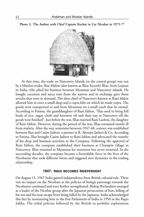
Andaman and Nicobar Islands42
Photo 2: The Author with Chief Captain Kuchat in Car Nicobar in 1975-77
At that time, the trade on Nancowry Islands (or the central group) was runby a Muslim trader, Ilias Malim (also known as Illias Yacoob) Illias, from Gujaratin India, who plied his business between Myanmar and Nancowry islands. Hebought coconuts and areca nuts from the natives and in exchange gave themarticles that were in demand. The then chief of Nancowry known as Rani Ishlonallowed him to erect a small shop and a copra kiln on which he made copra. Thegoods were transported to and from Myanmar on a small yatch that he owned.According to Fatima, the granddaughter of Rani Ishlon, “Ilias used to bring fullloads of rice, sugar, cloth and kerosene oil and then stay at Nancowry till thegoods were finished”. Just before the war, Illias married Rani Lachmi, the daughterof Rani Ishlon. However, during the period of the war, Illias remained mostly illfrom malaria. After the war, sometime between 1947-48, contact was establishedbetween Ilias and Casim Jadwet, a partner in R. Akoojee Jadwet & Co. Accordingto Fatima, Illas brought Casim Jadwet to Rani Ishlon and advocated the transferof his shop and business activities to the Company. Following the approval ofRani Ishlon, the company established their business at Champin village inNancowry. Illias returned to Myanmar for treatment but never returned. In thesucceeding decades, the company became a formidable force in the lives of theNicobarese that took different forms and triggered new dynamics in the tradingrelationship.
1947: INDIA BECOMES INDEPENDENT
On August 15, 1947 India gained independence from British colonial rule. Therewas no impact on the Nicobars as the policies of benign patronage towards theNicobarese continued and were further strengthened. Bishop Richardson emergedas a leader of the Nicobar group after the Japanese persecution of him, killing ofhis son and his near escape from being killed by the Japanese. India acknowledgedthis fact by nominating him to the first Parliament of India in 1950 in the RajyaSabha. The tribal policies followed by the British to prohibit exploitation
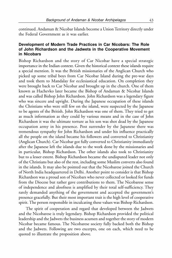
43Background of Andaman & Nicobar Archipelagos
continued. Andaman & Nicobar Islands become a Union Territory directly underthe Federal Government as it was earlier.
Development of Modern Trade Practices in Car Nicobars: The Roleof John Richardson and the Jadwets in the Cooperative Movementin Nicobars
Bishop Richardson and the story of Car Nicobar have a special strategicimportance in the Indian context. Given the historical context these islands requirea special mention. It was the British missionaries of the Anglican Church whopicked up some tribal boys from Car Nicobar Island during the pre-war daysand took them to Mandalay for ecclesiastical education. On completion theywere brought back to Car Nicobar and brought up in the church. One of themknown as Hachevko later became the Bishop of Andaman & Nicobar Islandsand was called Bishop John Richardson. John Richardson was a legendary figurewho was sincere and upright. During the Japanese occupation of these islandsthe Christians who were still few on the island, were suspected by the Japaneseto be agents of the British. John Richardson was one of them. They tried to getas much information as they could by various means and in the case of JohnRichardson it was the ultimate torture as his son was shot dead by the Japaneseoccupation army in his presence. Post surrender by the Japanese there wastremendous sympathy for John Richardson and under his influence practicallyall the people on the island became his followers and converted to Christianity(Anglican Church). Car Nicobar got fully converted to Christianity immediatelyafter the Japanese left the islands due to the work done by the missionaries andin particular, Bishop Richardson. The other islands also took to Christianitybut to a lesser extent. Bishop Richardson became the undisputed leader not onlyof the Christians but also of the rest, including some Muslim converts also foundin the islands. It may also be pointed out that the Nicobarese joined the Churchof North India headquartered in Delhi. Another point to consider is that BishopRichardson was a proud son of Nicobars who never collected or looked for fundsfrom the Diocese but rather gave contributions to them. The Nicobarese senseof independence and aloofness is amplified by their total self-sufficiency. Theyrarely demanded anything of the government and accepted the government’spresence gracefully. But their most important trait is the high level of cooperativespirit. The person responsible in inculcating these values was Bishop Richardson.
The spirit of cooperation and regard that developed between the Jadwetsand the Nicobarese is truly legendary. Bishop Richardson provided the politicalleadership and the Jadwets the business acumen and together the story of modernNicobar became famous. The Nicobarese society fully backed both the Bishopand the Jadwets. Following are two excerpts, one on each, which need to bequoted to illustrate the proposition above.
Andaman and Nicobar Islands44
“A Miracle in Paradise”
The Jadwets reversed the years of exploitation by traders in South-East Asia byinstructing the Nicobarese in how to do business in Copra and Betel Nut andby helping them set up a steady backbone of co-operatives.
The Jadwets arrived back in Nicobar along with allied forces in 1945. TheJapanese had been in occupation of these islands since 1942. The Jadwets mandatewas simple: to run a monopolistic but fair trade with the Nicobarese who evenin the forties did not know the use of money and relied entirely on barter. Theywere to take back in their sailing ships Saffena betel nut and copra and providethe islands with essentials. Nicobars seems to have soon cast a benign eye onJadwets. A monopoly trade became an almost romantic mission to organise thetribals into a profit making co-operative so that the tribals could also put awaycapital.
The Jadwet firm was converted into Car-Nicobar Trading Company in which14 co-operatives held 50 per cent share and had representatives on the board.With a similar formula, Nancowry Trading Co. was set up. By 1967, the Jadwetssold their 50 per cent stake in both firms to the Nicobarese and lost the monopolythey had once enjoyed through a decree.
But the link has not been exactly severed. Cassim Jadwet still serves as anadvisor to the co-operative. His nephew, Yusuf, is a salaried chief executive EllonHinengo.
(Extract from an Article in the Telegraph, December 4, 1988)
Press Report on unveiling of statue of Bishop Richardson in 2010 in CarNicobar.
“Port Blair, September 18: The Lt. Governor, Lt. Gen. (Retd.) BhopinderSingh, PVSM, AVSM today unveiled the statue of Rev. Dr. Bishop JohnRichardson at a function held at St. Thomas Cathedral, Mus village, Car Nicobar.The Lt. Governor also inaugurated a Church mela and interacted with the tribalyouth on the occasion. Dr. Purely Lyngdoh, Moderator, CNI, Rev. P.P. Marandih,Deputy Moderator, CNI, Rev. Bishop, Christopher Paul, Bishop of Andaman& Nicobar Islands, Diocese, CNI and Chief Captain, Car Nicobar, Shri AberdeenBlair were also present on the occasion.
Addressing the function, the Lt. Governor said that it was the greatness ofBishop John Richardson, who had a vision to see that the education of the Nicobaripeople was the most important priority for development of the community andprogress in every walk of life. It is only a great man like him who could carry outthis transformation of a primitive tribe to the mainstream by pursuing the policyof literacy and social transformation to catch up with the modern world.
The Lt. Governor said his emphasis was to improve the literacy standard ofNicobari people on priority and for accomplishing the objective, every possible
45Background of Andaman & Nicobar Archipelagos
effort was being made to give the Nicobari people good education in the islandsas also in the mainland. The large number of Nicobari students studying inhigher courses in New Delhi and undergoing various vocational courses inChandigarh were testimony of the same, he said.
The Lt Governor described Bishop John Richardson as the most revered,popular and distinguished son of Nicobar. He said Bishop John Richardson, theFather of Modern Nicobar and a torch bearer of the Nicobarese communitydevoted his entire life to spreading the message of Jesus Christ and worked forthe overall development of Car Nicobar. “He was a man of culture and saintlinesswho brought Nicobarese in the mainstream without losing their good oldtraditions and customs”, he said.
Highlighting the achievements and contributions of Bishop John Richardsonin the overall development of Nicobar, the Lt. Governor said after completinghis higher education from Myanmar, Bishop John Richardson preferred to stayback in Nicobar and worked for the all- round development of Nicobari peopleand with a missionary zeal, he established schools in villages and prepared theNicobari language dictionary and Nicobari Primer. The starting of cooperativemovement in 1947, the Nicobarese Athletic Association, the Captain System,Village Council and Tribal Council were among the major steps taken by BishopJohn Richardson for the benefit of Nicobari people, he said.
He also translated the holy bible into Nicobari language which was printedin Bangalore in 1970.
The Lt Governor noted with appreciation that the magnificent Church, whichwas the first Church in Nicobar and destroyed by the 2004 earthquake had beenre-erected by the Nicobari people themselves.
The re-erection of the Church had instilled a sense of self-sufficiency andconfidence amongst all, he added.
The Lt. Governor was all praises that a number of Nicobari students werealso pursuing higher courses like MBBS and engineering in various educationalinstitutions in the mainland. He urged the Nicobari youth to work hard, makethe community proud and bring name and fame to Nicobar by excelling in everywalk of life. Later, interacting with the Tribal Captains, he directed the head ofthe departments to attend to the problems of the people on priority.”
Out of the total tribal population in the Andaman & Nicobar Islands, theNicobarese are only tribe which showed drastic changes in their life style withina span of two decades. From a primitive lifestyle they had started to move closeto full integration. While the Moravian Missionaries of Denmark wereunsuccessful in establishing their mission, the Missionaries of the Anglican Churchwere able to achieve much more. This was mainly because in mid 19th Century,they took with them about a dozen boys from Car Nicobar to Mandalay inMyanmar (erstwhile Burma) where these boys were given full instructions in
Andaman and Nicobar Islands46
Bible studies and also taught English. On return one of them became the Bishopof the island and also their political leader. Rev. John Richardson, as he wascalled later was instrumental in modernising the entire island and the outlook ofthe tribals. When India became independent of the British in 1947 JohnRichardson was nominated to the Rajya Sabha, the upper house of the IndianParliament. Bishop Richardson combined the qualities of a preacher with amoderniser and brought modernisation to the islands.
Nicobarese Start their Own Business
The private traders from different parts of Asia operated in Car Nicobar beforeWorld War II. The main attraction of these islands was coconuts and copra.The private traders would come in their sailboats and offer goods on barter.Often the terms were harsh and Nicobarese being innocent were easily taken fora ride. They also did not allow the Nicobarese to do business on their own byinstructing the sailors not to provide any space in the ships. Messers R. AkoojeeJadwet & Co., stand out as their behaviour was much better. They realised thedifficulties faced by the Nicobarese while conducting business of their ownproduce, encouraged them by providing space in their vessels to export theirproduce to Myanmar. Thus, the Nicobarese started businesses of their own withtheir local produce with the help of Jadwets.
From Barter to Monetary System
Earlier the barter system prevailed when the business was managed by the traders.The Nicobarese never had the opportunity for use of money as coconut wastheir currency. The traders were also able to exploit them more with coconut asan instrument of barter.
On appointment of Jadwets as sole traders in Nicobars, money transactionand weights and measurement system was introduced. It took quite a while forNicobarese to accept currency as they did not know the value of money. As theirwants were limited, they did not feel the need for currency. Their produce wassold for purchase of necessary requirements. They rather preferred to have bartersystem. Whenever the company paid the surplus money in the form of coinswith which they were not acquainted, they had a practice to keep the coins inthe holes in the side of the walls. At times they even left them behind in theshop. The company’s employees were taking pains to trace out the concernedperson to handover the coins. In the process the company developed a cordialand amicable relation with Nicobarese and became their trusted friend and helpedthem in all walks of life.
47Background of Andaman & Nicobar Archipelagos
Introduction of Cooperative Movement
Bishop John Richardson in consultation with the then Chief Commissioner ofAndaman & Nicobar Islands and Jadwets thought out a plan to introduce thecooperative movement in the Nicobars so that the Tribals get empowered. Thethen Chief Commissioner of Andaman & Nicobar Islands Mr. L.A. Majeed,I.C.S and the Assistant Commissioner Car Nicobar, Mr. Sharma, activelyencouraged the proposal of the Bishop in empowering the tribals and makingthem owners of their trade.
As a first step, following encouragement from all quarters, the first cooperativesociety was organised in Kinmai village in the year 1948 with a meagre sharecapital of Rs.45/- . Later the cooperative movement extended to other villages ofCar Nicobar and all the Primary Cooperative Societies locally named as PanamHinengo in Car Nicobar were organised between the years 1945-51. Later, thismovement was extended to all islands of Nicobars.
The Jadwets were fully cooperative and supportive. Their company wasrendering help to the maximum extent to maintain records and accounts of thePanam Hinengos. The introduction of cooperative movement in Car NicobarIsland had strengthened the democratic character among the inhabitants. PanamHinengos also started playing a pivotal role in the day to day affairs of the villages.They not only acted as business units but also helped in establishment of discipline.The financial structure of the Panam Hinengos showed a remarkable growthyear by year.
The success of economic ventures through village cooperatives or PanamHinengos created a change in outlook of the tribal society as owners of an enterpriseand slowly led them to reap the benefits of modern business without disturbingthe tribal social values. This change was peaceful and fully controlled by thetribal society and there was no conflict as was happening with the traders earlier.
The Panam Hinengos in Car Nicobar originally established with membershipof 279 contributed by a share capital of Rs. 13,275/- has shown remarkableprogress in the decade. Mis. R.Akoojee Jadwet & Co., besides its business alsocontributed towards the upliftment of the Nicobarese tribes in all walks of life.The Nicobarese were slow to understand and needed proper guidance.
The company personnel and many non-tribals were also well wishers of thetribals as part of the philosophy of the company. They also helped in utilisingvarious schemes of the government by providing help in understanding anddrafting. The day to day contact with the company personnel and governmentofficials paved their way to learn several things necessary for their daily routinelife. It was also the policy of the company to employ more and more tribals asthey became educationally eligible.
Andaman and Nicobar Islands48
1956: Nicobarese Become Partners
Another important change in the business model of Nicobars took place in 1956.With the growth of trade and the village cooperatives or Penam Henengosbecoming mature with tribal management, the Jadwets in consultation withBishop Richardson and other leaders of the community decided to convert theircompany Akojee Jadwet & Co into “Car Nicobar Trading Co.” This was donewith effect from January 1, 1956 with 50 per cent share held by the 14 PanamHinengoes or Car Nicobar. The Partnership consisted of 19 partners of whichfive belonged to the erstwhile trading company of the Jadwets plus presidents of14 Panam Hinengos. Thus, the local people were not only members of theirvillage cooperative but also part owners of the apex company called “Car NicobarTrading Company.”
Thus, Nicobarese were given ample scope to learn business methods andmanagement despite their low but rising educational qualifications. Theintroduction of cooperative movement in Nicobar Islands gave a new shape andmeaning to the life of Nicobarese.
1967: Nicobarese Become Full Owners of Their Company
Another major change took place after a decade. This was regarding handingover trade to the tribals. Car Nicobar Trading Company decided to hand overthe entire trade to the tribals. This was done by converting Car Nicobar TradingCompany which had 50 per cent shares held by Akoojee Jadwets to NicobareseTrading Company with 100 per cent tribal ownership. Thus, Nicobarese becamethe 100 per cent owners of their business. This was done by formation of M/s.Nicobarese Commercial Company in Car Nicobar on July 1, 1967 after takingpossession of the liabilities and assets of Car Nicobar Trading Company. Theshareholders of the new Company were just the 15 Panam Hinengos (Coop.Societies) of Car Nicobar.
All these years while the cooperative movement gained momentum, thefinancial position of primary cooperatives also showed a geometrical growth,crossing all the initial teething problems. The profits earned by the companywere annually distributed to their member Panama Hinengos. Ultimately, theindividual member i.e. the villagers were getting benefits in the shape of dividendand bonus. Here, the advantage of professional management by Jadwets alongwith training and internship of young Nicobarese kept the society and socialstructure in good shape.
The Nicobarese Trading Company, new 100 per cent tribal owned, however,continued its partnership with the Jadwets. While Jadwets provided technicaland financial staff for supervision, the local people were brought into employmentin their cooperative.
49Background of Andaman & Nicobar Archipelagos
In the year 1977 a high power team, headed by the then Managing Directorof National Cooperative Development Corporation (NCDC) was sent to theNicobars to explore the future potential of Nicobar trade. The team visitedAndaman & Nicobar Islands from January 10-18, 1977 and after a detailed indepth study suggested certain changes to their business practices. Relevant extractsare as follows:
The Nicobarese Commercial Co., (NCC) has been acting as a central levelorganisation for marketing of copra and betel nuts and for supply of consumergoods. This company which is a private partnership firm is now entirely ownedby the 15 “Panam Hinengos” (Multi-purpose Coop.) of the island, the earlierprivate firm having completely withdrawn its shares. Although, it is a partnershipfirm for all practical purposes, it is a cooperative federation of the “PanamHinengos”. The Board of Management is elected by the Panam Hinengos. Thereis no distinct advantage in continuing it as a partnership firm since the earlierprivate firm has withdrawn and it is now owned and managed by the primarycooperatives. On the other hand, there are several advantages in converting theNCC into a cooperative. Firstly, the society would be able to obtain financialassistance from the government and NCDC for expansion of its activities onfavourable terms. Secondly, concessions in the matter of income tax, stamp duties,etc. would be available.
During the discussions that the team had with the office bearers of NicobareseCommercial Company and the captains of the villages, there was generalagreement to the conversion provided the existing arrangements were not to bedisturbed. It was, therefore, recommended that the Nicobarese CommercialCompany may be converted into a Central Marketing and Supply Society.
However, NCDC felt that since the existing arrangements for managementand procurement/sale of goods seemed to be satisfactory and the local populationwas not in favour of any major change it was suggested that even after conversioninto a cooperative existing arrangements of management etc. may be allowed tocontinue. “Since, this is a sensitive tribal area, it has to be observed that the localsentiments are not offended and any changes necessary are made with theconcurrence of the members of the societies for their larger benefit. In due courseof time, changes necessary for further improvement of the service may be madethrough persuasion and education. The existing arrangements for remunerationto the office bearers may also be continued until the members require changes.Likewise, the present staff of the society who have gained experience may not bechanged. The present arrangement for sale/procurement of goods may becontinued for sometime till better alternative sources are found and the membersconvinced of the need for change. Caution needs to be exercised in this regard.”
Andaman and Nicobar Islands50
1977: Nicobarese Form an Apex Cooperative Called Ellong HenengoWhich Is Wholly Tribal Owned
On the strength of the recommendation of the High Power Team sent by theGovernment of India headed by Managing Director of NCDC, the Nicobaresereadily agreed for the conversion of the private partnership firm i.e. theNicobarese Commercial Co., to a Central Cooperative Society. Necessary by lawswere drafted in consonance with the Cooperative, Regulation No.3 of 1973.The proposed Central Cooperative Marketing Society under the Nicobarese name“Ellon Hinengo Limited” was registered on April 5, 1977 with RegistrationNo.251 by the Registrar of Cooperative Societies, Andaman & Nicobar Islands.The actual functioning of the Central Cooperative Society that is “Ellon HinengoLimited” started from July 1, 1977, the beginning of the cooperative year. It isnot out of place to mention that a legendry ship called Safeena, originally aminesweeper of the British Navy, owned by Ms. R. Akoojee Jadwet & Co. wastransferred ultimately to the Central Cooperative Society (Ellon Hinengo Ltd.,)at a token value. Akoojee Jadwet, however, continued to provide support withtechnical manpower and higher level executives. The CEO of the Jadwet familycontinued after the transition at the request of the cooperative. Thus, day today affairs and business of the Nicobarese were brought under the cooperatives’fold. The tribes have earned a reputation and goodwill in cooperative fieldshowing their full fledged participation in cooperative activities followingdemocratic principles.
M/s Ellon Hinengo Ltd. of Car Nicobar played a major role to uplift thesocial and economic condition of the tribal society without prejudices to thecustoms and habits of the Nicobarese of Car Nicobar. Within two years of itsestablishment it could acquire a larger ship capable of going in the ocean forRs.55,00,000 with a loan from NCDC under the flag of a Company registeredunder the Companies Act, 1956 as Hinengo Lines Ltd. The ship now carriescargo between Andaman & Nicobar Islands and Mainland India. The Merchantshipping Act was amended enabling a cooperative society to own ships andHinengo Lines Ltd. was liquidated. With the financed support from NCDC ofIndia the society could acquire four more cargo vessels and the total cargocarrying capacity now is 5360 DWT. The tribal cooperative of Car Nicobar isnow a shipping concern also and one of its ships does not come to Car Nicobarat all but carries cargo between other destinations.
As part of social obligation to society Ellon Hinengo Ltd., has taken anotherstep in connection with the encouragement of culture and entertainment andconstructed a hall in Car Nicobar at a cost of about Rs.7,00,000 with a seatingcapacity of 600. This hall is used mainly for showing cinema but can be usedfor other purposes as well.
51Background of Andaman & Nicobar Archipelagos
The society has made another leap forward by establishing an engineeringdivision to undertake civil construction works on contract from defence and civildepartments of the government.
There is a plan to establish a copra drying unit to maintain the quality ofcopra and to shift from the present traditional practice of drying the copra by theheat of the firewood. This project will be of great help to the Nicobarese to fetchprofit for good quality of copra. The NCDC has come forward with financialassistance for the project.
The society has yet another scheme to establish cold storage in Car Nicobaravailing the financial assistant from NCDC.
Nicobar group of islands are rich in marine resources. Ellon Hinengo Ltd.,is also planning to establish a Deep Sea Fishing Project and the scheme is underactive consideration of NCDC.
Establishment of an Oil Industry (coconut oil) is also taking shape in viewof its potential in availability of raw materials. This project would meet the localdemands for this territory and the marketable surplus will be exported to themainland.
Another noteworthy feature is that the government and financing agenciesare happily coming forward to provide finances required. It is perhaps a matterof pride for all to see the development that has shaped the Nicobarese tribes dueto their cooperative movement, in particular, encompassing economic activities,and democratic management within a short span of little over 30 years. This hastransformed the tribal society to embrace the benefits of modern civilisation andthe country needs to be proud of it, especially as it has happened in the remotestpart of the country and even the World.
Former Prime Minister of India late Mrs. Indira Gandhi, who visited thesociety in Car Nicobar on March 7, 1981 had recorded her appreciation on theworking of the society as under:
‘I am glad to hear of the excellent work of the Car Nicobar CentralCooperative Society. I give my best wishes to the Society and to the peopleof this beautiful Island. We want to help them towards a better life, whilekeeping their own personality and culture.’
2004 TSUNAMI AND THE NICOBAR ISLANDS:ROLE OF ELLON HENONGO
On December 26, 2004 a tsunami hit the Nicobar Islands. The earthquake’sepicentre was 163 km away from Great Nicobar, the southernmost island fromthe archipelago. It was strongly felt in the entire Andaman Nicobar group ofislands and the seismic intensity was enough to cause major damage to many
Andaman and Nicobar Islands52
civil infrastructures. The total duration of the shaking has been reported by manyto be 600 seconds.
The tsunami generated from the Sumatra earthquake caused most damageto the low lying coastal regions of the Nicobar group of islands. The sea rose toabout 4.25 m above the high tide line in Great Nicobar. The sea water surgedat nearly 700 km per hour and flattened whatever came in its way. It flooded thevillages, breached the shore protection walls, certain sections of the low levelroads, impaired some bridge and harbour structures and inundated the vaststretches of the shore line. It broke homes and hearts.
The statistics of severity of human loss does not indicate the level of thetragedy. 3400 people died or were missing. The Indian Air Force (IAF) stationat Car Nicobar alone lost 116 personnel and the airfield was damaged.
A large number of coconut trees got ripped off and the basic infrastructurewas severally damaged.
Social and economic infrastructure in these islands was severely damaged.68 schools were fully damaged, 40 Anganwadi (women and child centres) becamenon-operational. Most of the health sub-centres were washed away. A total of 84fair price shops and 13 storage godowns were also lost to the surging waves.
The power supply system in all the islands were badly damaged. The 2,400KVA capacity main power house at Malacca, Car Nicobar was washed away.85 km of transmission line and 12 distribution transformers were lost. Extensivedamage was caused to the power houses, DG sets, T&D systems, transmissiontowers, power distribution transformers, buildings etc. in most of the islands.
24 jetties were severely ruined. In Car Nicobar, the approach to the Muswharf was partly damaged while the Malacca jetty was totally destroyed. InCampbell Bay, the approach to the jetty collapsed completely. The jetties atChowra, Teressa, Katchal were submerged in water and washed away. Cracksdeveloped in jetties at Kamorta and Nancowry.
Seven shipping vessels were damaged and two vessels sunk in the sweep oftidal waves. Propellers, hulls, shaft, superstructure etc. were damaged in the abovevessels. 38 boats were lost. A forty 40 ton diesel storage tank was uprooted in CarNicobar.
Road network in most of the affected islands was badly affected. In someplaces, the roads were washed out while in other cracks developed. The ring roadwhich passes through the entire island of Car Nicobar was completely sunk inand is irretrievable. In Great Nicobar, the main trunk road connecting IndiraPoint became unserviceable thereby disconnecting all villages which were situatedacross it.
There was extensive damage in the water supply network. Wells in the flatlands were flooded with seawater. IAF wells which were catering to around 1,700people got saline. Almost the whole water supply network became non-operational
53Background of Andaman & Nicobar Archipelagos
barring the area near the administrative headquarters in Car Nicobar. As a resultof the killer tsunami, the economy of these islands was severely affected. Thebusiness community suffered losses by way of damages to stock, loss of revenue,and losses to property and infrastructure particularly in Great Nicobars. Thewhole market at Campbell Bay was flooded with water.
The Directorate of Shipping Services of the Andaman & NicobarAdministration, which controls and runs the entire government owned fleet ofships for the Andaman & Nicobar Group of islands, was helpless in providingships to the southern Islands. With no ships plying to the island for more thana fortnight, the situation of the residents went from bad to worse. Power supplybased on imported diesel was restricted to four hours a day, private and publictransport had stopped, and scarcity of food loomed large over the residents.
The last ship that reached Car Nicobar was on November 28, 2011. Afterthat it was mere assurance by the Directorate of Shipping Service.
Acting as a messiah, Ellon Hinengo Limited (EHL) decided to sail its ship‘MV Nicotrade’, with 1,700 tonnes of cargo. The ship sailed on December 28,2011. EHL knew well that the amount of cargo transported was just a relief forthe residents. To support the islanders, EHL had decided to do its maximumwith whatever minimum infrastructure available with the cooperative.
The Ellon Hinengo Ltd., which had nearly completed 30 years of existence,had also been very badly hit by the severe earth quake and Tsunami killer waves.The society’s retail shops in all the 15 villages of Car Nicobar along with stockin trade, records, account books, cars and vehicles go downs at jetties etc. gotwashed away and nothing remained.
The total loss suffered by the society due to the tsunami was estimated at Rs100 million. The entire infrastructure for the society had to be rebuilt, apartfrom the need for the working capital for the revival of its retail outlet branches.
The society had also lost 14 staff members and three family members.However, the society pulled up its socks and is again back fully functioning.
CONCLUSION
The transformation of a tribal society from a position of exploitation by tradersdue to their innocence and lack of education to running their own businesssuccessfully and running their own shipping line with four ocean going ships isa remarkable achievement, especially considering the remote location of the island.
It may further be stated that in many parts of the world both developed anddeveloping tribals have been exploited by the outsiders. It is to the good luck ofthe Nicobarese that the British Government restricted land ownership to tribalsand also regulated trade by foreign traders since mid 19th Century. The successorGovernment of India continued this enlightened policy. It is also a matter ofluck that the combination of enlightened tribal leadership of Bishop John
Andaman and Nicobar Islands54
Richardson and the business acumen of the Jadwets was able to transform theJadwet monopoly into a cooperative movement. Further, the NCDC was alsoimpressed by the working of the cooperative and agreed to sanction funds insufficient quantity to purchase ships.
There is a still brighter future for the Nicobars. This is because the truepotential of these islands have not been realised. As the tribal society matureswith education it will be able to get the advantages of the next phase ofdevelopment which can be high end tourism. The strategic location of theseislands is to be understood and leveraged. The last island is barely 100 km fromSumatra. Direct flights to Car Nicobar airport from Singapore or Phuket willnot be even an hour away. Additionally, if small sea planes are deployed then allthe islands can be covered from these areas.
The coral reefs and fishing are both outstanding. The Government of India’sprotective policy towards Nicobar which prohibits foreigners and restricts evenIndians needs to be liberalised. With proximity from South-East Asia there shouldbe leveraging of this advantage. Today, even to visit Andaman Islands touristshave to come first to Chennai or Kolkata and then go to Port Blair. Once directflights start from Phuket or Singapore or Bali or any other tourist point in thatregion, things are going to change dramatically for these islands. Mass tourismcan be destructive.
Besides the strategic location, these islands present a paradise forenvironmentalists. With their excellent tropical forests and coral reefs they offerone of the best options for eco-tourism. It has 96 wildlife sanctuaries, nine nationalparks and one bio-sphere reserve all well protected.
NOTES
1. For a full review of the historical background including the freedom struggle, see B.R.Tamta, Andaman & Nicobar Islands, National Book Trust, New Delhi, 1992.
2. R.V.R. Murty, Andaman & Nicobar Islands: a Geopolitical Perspective, Northern Book Centre,New Delhi, p. 27.
3. Ibid, p. 82.4. Ibid, p. 114.5. Ibid.6. Rev. Canon John Richardson, Car Nicobar under Japanese Occupation: 1943 to 1945, June
1947 unpublished, p. 4.7. C.M. Jadwet, Jadwet Saga, Private Publication, 2004.8. See n. 1, p. 40.9. Ibid., p. 65.10. See n. 6, p. 27.11. See n. 7.12. Ibid.
55Importance of Straits of Malacca
CHAPTER 3
Importance of Straits of Malacca
“Peace, Stability and Freedom of Navigation in the Pacific Ocean areinseparable from Peace, Stability and Freedom of Navigation in the IndianOcean – Shinzo Abe, Prime Minister of Japan”.1
WHY STRAITS OF MALACCA IS THE PREFERRED OPTION?
Strait of Malacca being 900 km in length is the longest international navigationalroute through a strait, as it connects the Indian Ocean via Andaman Sea on thewest with South China Sea on the east via the Strait of Singapore. The straitprovides the shortest route for ships to reach between East Asia and Europe.With the narrowest point being 11 miles and width between 11 to 200 nauticalmiles (nm), the seaway in this strait is not always wide as at certain parts of thestrait, the navigable route is less than one nm and a certain part of its navigablearea is less than 30 metres deep. At a particular point on the strait, the maximumdraught recommended by the International Maritime Organisation (IMO) forpassing ships is 19.8 metres. However, even with such limiting navigationalconstraints in the Strait of Malacca, the Strait is still an attractive and preferrednavigational route for international shippers compared to other alternative routeslike Sunda or Lombok-Makassar Straits in the Indonesian archipelago.2
The first alternative is the 80 km long Sunda Straits. It is 15 miles wide onits north-eastern entrance but the strong currents and limited depth has preventeddeep-draft ships of over 100,000 Dead Weight Tons (DWT) from transiting thisstrait. Moreover, the Sunda Strait is unsuitable as it has highly irregular bottomtopography of the Straits and the presence of rip tides render it unsuitable forvessels drawing over 18 metres of water to use the Straits. In addition, there arehazards posed by the numerous oil drilling platforms to the north of WesternJava. The Sunda Straits has yet no available detailed navigational map.
The second alternative is the Lombok Strait. With a minimum passage widthof 18.5 km and depth of more than 150 metres, the Lombok Strait, on the otherhand, is the safest route for supertankers because it is wider, deeper and lesscongested than the Strait of Malacca. Lombok Strait does not feature serious
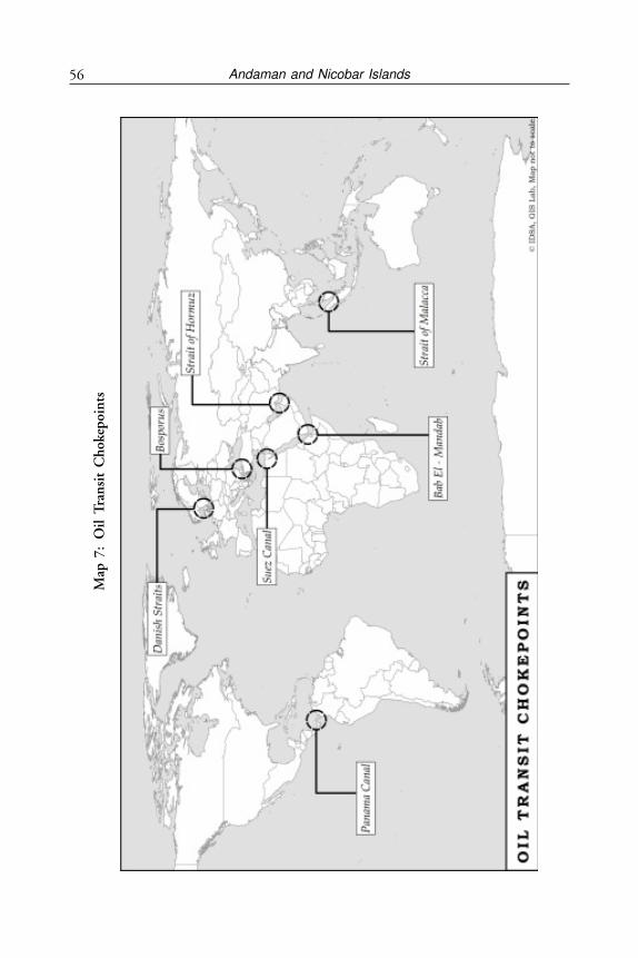
Andaman and Nicobar Islands56
Map
7:
Oil
Tra
nsi
t C
hok
epoi
nts
57Importance of Straits of Malacca
navigational hazards along the navigational channel but the routes require anadditional three and a half days navigating at full commercial speed of 14-16knots, an extra mileage of 1,600 nm, which add to transportation cost where inthe long term operation it is not profitable to the tanker operators.
Closure of Straits of Malacca will cause a major economic disaster. Theblockage and bombing of the Suez Canal in 1956 was a crisis of internationaldimensions. It was done when President Nasser of Egypt nationalised the SuezCanal Company after the refusal of US and Britain to finance the constructionof Aswan High Dam in Egypt. He felt that tolls from Suez Canal could helpbuild the dam. This was then a major international economic crisis as the SuezCanal was closed with 46 ship wrecks after its bombing by the British. SuezCanal was also a major choke point like Straits of Malacca when at that time 10per cent of global oil passed through it. The blockage of Suez Canal in 1956 isa reminder of what could happen to Straits of Malacca. The present Iranian threatof blocking the Strait of Hormuz, through which one fifth of world’s traded oilpasses, could become a reality if US and Iran are not able to come to anunderstanding over the Iranian Nuclear Programme.
During World War II, the Malacca and Singapore Strait were mined. Thebattle of Malacca Strait led to sinking of the Japanese ship Hugaro around theend of the war. Currently, the three states of Singapore, Indonesia and Malaysiamaintain submarines in the straits. India and Thailand are not known to havedeployed submarines in this region. According to Michal Jarocki, no nation cancontrol the traffic through the strait relying on military strength alone. Developingand maintaining a dominant position in the region also requires strong and positiverelations with the regional straits.3
Based on these facts and fears, a concern has been raised by the internationalcommunity that would immediately raise freight rates. Freight rates around theworld would be affected, thus adding costs to many nations’ imports and exports.The closure of the Strait of Malacca is not such a big problem because there arealternative routes like Sunda Straits or Lombok-Makasar Straits. In reality, however,the cost of re-routing maritime traffic, especially oil tankers, can be expensive. Todivert the tankers on the Middle East-Japan route from Malacca to the LombokStrait would cost more than US$ 340 million per year to the Japanese petroleumindustry. The Straits of Malacca is, therefore, a critical chokepoint of world oiltrade because a huge quantity of oil passes through it, and this number is expectedto increase significantly in the next coming decades.
PIRACY AND ITS IMPLICATIONS FOR ANDAMAN & NICOBAR ISLANDS
AND STRAITS OF MALACCA
The 900 km long Straits of Malacca has Malaysia and Thailand on its northand Indonesia in the south, with Singapore in the east and India in the west
Andaman and Nicobar Islands58
(Great Nicobar Island). Piracy in the Straits of Malaccas has been known formany centuries and is a historic fact. The strait is narrow, contains thousands ofislets and is an outlet for many rivers making it an ideal location for piracy asthe pirates can easily hide at a very large number of places. Traditionally, piracywas practically state sponsored or an important political tool of the adjoiningstate. It is said that in 14th century Parmeshwara, a Palembang prince used piratesto protect his kingdom from other kings and which later led to founding of theSultanate of Malacca. In 18th and 19th Century as European colonisers arrivedpiracy picked up. Even Chinese pirates were found to be operating in these waters.In 1830s, the British and the Dutch agreed to curb the rampant menace of piracyin the Straits of Malacca. They even drew a line of demarcation of the straitbetween themselves and took up the job of fighting piracy on their side of thedemarcation. Their success in curbing piracy was substantial in those days.
The present scenario regarding piracy in Straits of Malaccas is that piracyhas been reduced and is coming under control. The International Maritime Bureau(IMB) reports on piracy worldwide. In 2004, Straits of Malacca accounted for40 per cent of the worldwide piracy. According to their report of 2006 piracy inthe Straits of Malacca fell for the third year. Attacks on ships in the Straits ofMalacca fell from 79 in 2005 to 50 in 2006. However, IMB reports that as lateas 2007 Indonesia continued to be one of the worst pirate infested regions with37 attacks since January 2007, though still an improvement over the previousyear. Only one hijacking and two kidnappings were reported in 2009. Although,the number of attacks have dropped substantially due to increase and aggressivepatrolling by the littoral states, ships are still advised to continue making a strictanti-piracy/robbery watch when they are transiting the straits.
Solving the menace of piracy: In 2004, the three countries on the Straits ofMalacca, namely, Indonesia, Thailand and Singapore, increased their efforts topatrol. While Singapore was in favour of international support, Indonesia andMalaysia were opposed to it. Indonesia had expressed that it does not have thefinancial means to provide full anti-piracy support. There are two other countriesthat are directly involved and they are Thailand and India. Royal Thai Navybased in Cape Panwa in east of Phuket is coordinating with other armed forcesfrom Singapore, Malaysia and Indonesia to combat pirates in the Straits ofMalacca. India has also joined the effort and the Indian Navy and the IndianCoast Guards have finally joined the multi-national piracy patrol in the Straitsof Malacca in 2006.India is also reportedly building a Un-manned Aerial Vehicle(UAV)-patrol base in the Andaman & Nicobar Islands.4
Use of technology in meeting the piracy menace is important. According toIMB’s 2006 report all large ships of over 500 gross tons now have to have asecurity alert system on board which includes real time ship location devices.There is also a system information system—a 14 nation pact to combat piracy.
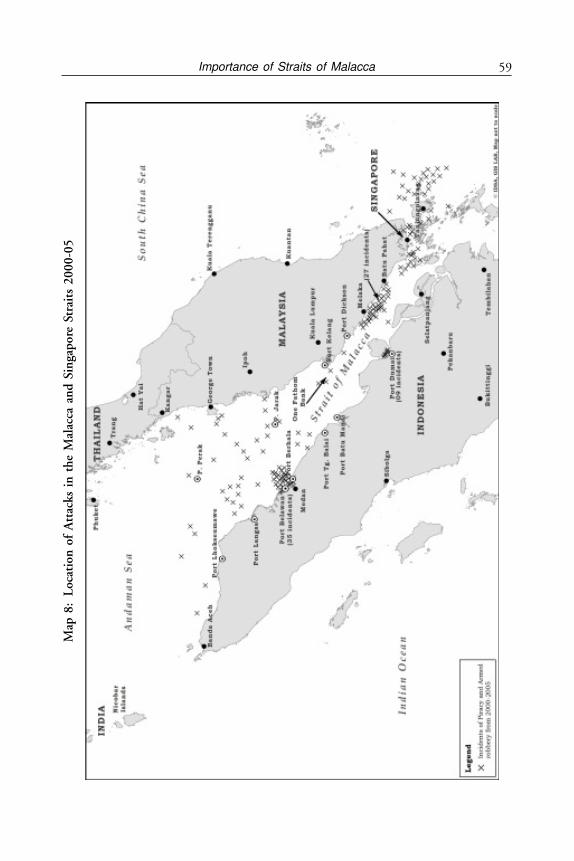
59Importance of Straits of MalaccaM
ap 8
:L
ocat
ion
of
Att
acks
in
th
e M
alac
ca a
nd
Sin
gap
ore
Str
aits
20
00
-05
Andaman and Nicobar Islands60
This is perhaps the first time that an international body has been set up to dealsolely with the problem of piracy in Asia.
IMB as an additional effort has also opened free of charge, a 24 hour PiracyReporting Centre (PRC) based in Kuala Lumpur in Malaysia. The main purposeof PRC is to make the shipping industry aware of the risk involved in the Straitsof Malacca and make it a single point of contact for ship Masters anywhere inthe world who are under pirate or armed attack. Further, information so receivedis immediately broadcasted to various governments and law enforcement agencieswithout delay. Such a service to ships under attack is a great service being providedthat too free. Donations, however, are accepted by PRC for its efficient functioning.Straits of Malacca Patrol (MSP), “Eyes in the Sky” (EIS) Air Patrol are two moregovernment organisations helping to control the piracy menace. The other is theInternational Exchange Group (IEG) set up for cooperative security measures byfour states namely Indonesia, Malaysia, Singapore and Thailand to ensure safetyof the Straits and to further cut down piracy.5
Lloyds of England, the famous and world leading insurance company, hadpreviously declared the Straits of Malacca as a war- risk area for insurance purposes.Such a declaration of high war risk leads to high insurance premium. By 2006they lifted this advisory after Singapore and Indonesia launched their sea and airpatrols, just two years after Singapore and Indonesia started their joint effort.Therefore, piracy in Straits of Malacca is on the mend. Piracy in other parts ofthe Indian Ocean like Gulf of Aden, Yemen and Somalia is another story. Yetpassage of billions of dollars of trade does not discount the fact that piracy in thisregion can start again. The isolated Nicobar Islands can become safe heavensunless full surveillance is kept by the Indian Coast Guard and Navy. In addition,threat of illegal migration and control of the vast EEZ of India around theseIslands is also an issue to be looked into.6
Piracy in Indian Ocean Region (IOR)
While piracy in Straits of Malacca is under control there is an increasing menaceof Piracy in the Indian Ocean. On the Arabian Sea side there is piracy going onin Yemen, the Red Sea and Somali coast. It is because of this that Straits ofMalacca also remains vulnerable. So far the situation is under control in thisregion but there is a need to maintain and reinforce the existing set up.
The area of operation of pirates in the Indian Ocean is now considered tobe about 2.5 million square nm. While Somalia has been the epicentre of thisactivity it is spreading to other areas also. Further, ransom payments by privateshippers has gone up and according to some estimates in 2010 alone about 1,181people and 53 ships were hijacked and ransoms averaging US$ 5.4 million pership were paid. It is also estimated that 30 per cent of the ransoms paid reachterror groups. The concept of ‘sea jihad’ is now being talked of. Further insurerLloyds have now stopped paying if ship owners paid ransom to pirates with terrorist
61Importance of Straits of Malacca
group links.7 While Andaman & Nicobar Islands are free of piracy with increasingpiracy along Somali coast and spreading towards Arabian Sea, it could well spreadtowards Bay of Bengal and Andaman & Nicobar Islands. It will, therefore, notbe prudent to assume that piracy in Straits of Malacca is over and propersurveillance is still required as there is every possibility of piracy getting revivedin the Straits.
Small Arms and Drug Trafficking in the IOR
According to Prof. Aparajit Biswas of Centre of African Studies, University ofMumbai,8 Andaman & Nicobar Islands Group is also very insecure. This is sobecause the waters around it are routes for Chinese gun-running to Bangladesh,from where arms reach North-East India. According to her this was the mainreason why the government of India upgraded security structures of the islandin 1998 and established a high service command to combat smuggling of armsand narcotics in the region. She further states that “Andaman & Nicobar Islandsprovide the key to the eventual success of India’s ‘look east policy’ enunciated byPrime Minister Narsimha Rao in 1990s.” It is the close proximity of these islandswith South-East Asia that makes India a part of this region as South Asia. It isevident that spread of illegal arms and drugs in IOR is alarming. Regionalassociations like ASEAN, ASEAN-ARC, Bengal Initiative for Multi SectoralTechnical and Economic Cooperation (BIMSTEC), Mekong Ganga Cooperation(MGC) Project have a great deal of potential. It may also be stated that exceptfor Laos all other countries are maritime countries. Under such a scenarioAndaman & Nicobar Islands of India provide the most ideal and logical basefrom where sea power could extend its reach.
The defence minister has announced some measures to revamp the CoastGuard setup as piracy is creeping closer to Indian waters. Radar coverage of India’scoast is increasing by addition of 46 coastal radars by 2012, Coast Guard stationsare going up from 22 to 42 and 12 more Dornier aircrafts are being acquiredalong with construction of a large number of ships at Indian shipyards. Alongwith this the manpower of the Coast Guards is also being increased by 50 percent. The minister has also proposed a joint command under the aegis of UN.9
On January 25, 2011 India’s permanent representative at the UN made theobservation that it was disturbing to see piracy increasing further and furtherfrom the coast of Somalia. The shift of attacks in south and east of Indian Oceanreflects the pirate’s ability to shift out of the traditional security corridor establishedby naval forces and extend their reach to approximately 1,000 to 2,000 milesfrom Somalia. The UNSC has anti-piracy provisions which need to assess anddeploy the international maritime fund. It may also be pointed out that aboutsix per cent of international seafarers engaged in international companies areIndian Nationals and therefore high-jacking of ships with Indian crew alsobecomes a problem of the Indian Government.
Andaman and Nicobar Islands62
CHINA’S MALACCA DILEMMA
The Chinese have referred to the Straits of Malacca as their “Malacca dilemma”.This is so because this strait is perhaps the world’s most important waterwaylinking the Persian Gulf with South China with about 40 per cent of worldtrade passing through it. It is the shortest route between India and the PacificOcean and carries a very large part of the gulf oil. Between the straits of Hormuzand Malacca there is a huge value of the world trade flowing. In so far as theChinese are concerned their oil imports from the Middle East are about 50 percent of their total import and will become 75 per cent by 2015. More than 80per cent of China’s oil imports are carried by tanker ships through the Straits ofMalacca. Any blockage of this route will derail their economic growth. The Straitis about 900 km long but around Singapore where it is called Philips Strait, itis barely 2.4 km wide. Daily nearly 12 million barrels of oil in super tankerspass through it. In a war scenario the Straits of Malacca can easily be a targetand blocked. Further, the question being raised is whether the Straits of Malaccais getting congested and over used with over hundred thousand ships passingthrough annually. The most pressing problem for China is the over reliance onoil from Middle East sources which comes through Straits of Malacca. Chinawould like to have a say in the administration of the Straits of Malacca. Theypresently feel that while piracy in the Straits can be controlled the saturation ofthis sea lane is going to cause deep problems for trade especially for them.
While China seeks to have a greater say in the administration of this sealane, the littoral countries do not want its participation, especially in view of itsdubious claims and show of force in South China Sea. Further, US as it is claimed,has managed to get a foothold with an airbase at Banda Ache, the Sultan SikanderMuda Air Force Base, on the northern most tip of Indonesia. In the meantimeChina has stepped up its engagement with Myanmar with millions of dollars ofmilitary assistance, has made the Myanmar Army the second largest army afterVietnam in South East Asia from 180,000 to 450,000 men and vastly moretechnologically sophisticated.10
Andaman & Nicobar Islands: Strategic Reach
About 30 per cent of India’s EEZ is a result of its sovereignty over these Islands.This issue is not fully appreciated by Indian policy makers. There is a need toleverage this great asset and the locational advantage of these islands. It mayalso be emphasised that Indian borders do not end with Indian peninsula butgo right up to Sumatra with these maritime assets deep in the Bay of Bengal.With declaration of Port Blair as a major port in 2010 and extension of thenaval airport by the civil administration to 11,000 feet along with its declarationas an international airport, a fresh impetus has been given to this island forpromotion of trade and tourism. However, with no international ships or airline
63Importance of Straits of Malacca
arriving in Port Blair so far this is a meaningless gesture. There has been littlevisible effort made in offshore oil exploration. With a huge EEZ the canvas ofIndia’s strategic region of planning becomes stretched. Indian Navy and Air Forcehave a much wider area to cover after United Nations Commission on the Limitsof Continental Shelf (UNCLOS) III gave an additional 0.66 million sq km ofEEZ in Andaman & Nicobar Islands. Consequently, the defence forces formedits first joint Tri-Command in 2001 in Andaman & Nicobar. This is a positivestep, as was necessary at this stage to complement the vast responsibility of EEZ.
The Andaman & Nicobar Islands stretch from south of Myanmar to Sumatra.As a result India’s maritime border also gets stretched. India has five countrieswith which it has a maritime border on the eastern side in the Bay of Bengal,namely Myanmar, Thailand, Malaysia, Indonesia and Bangladesh. Though,Bangladesh is quite far away from these islands. As under-sea surface wealthbecomes extractable the value of the Economic Zone gains importance. Thenthere is also the issue of Continental Shelf. The limits of the continental shelf asrequired by the UNCLOS are still to be determined.
India’s Malacca Advantage
According to Robert D. Kaplan in his book Monsoon: The Indian Occean andthe Future of American Power “Hemmed in on land by a combination ofHimalayan Mountains and failing states of Pakistan, Nepal, Bangladesh andMyanmar, India can best project power at sea. India stands sentinel astride themajor sea lanes from the Strait of Hormuz to Strait of Malacca, where the threatof naval containerised terrorism is very real.... India can play the role of chiefbalancer vis-à-vis China.”11
It is to India’s advantage that the Great Nicobar Island is only 90 km from thewestern tip of Straits of Malacca. India’s serious land border issues with China includingthe unfortunate acceptance of Tibet as a region of China in 1954 without a quid proquo, the Chinese meddling in the disputed Kashmir issue with Pakistan, and thestring of pearls policy adopted by China can only be countered by using the strategicadvantage that India has in the Bay of Bengal. As strategic depth of world powersshifts to Indian Ocean and growth in international trade, the importance of Straitsof Malaccas increases, especially for China. India’s most strategic asset in Andaman& Nicobar Islands is the Great Nicobar Island (GNI). The fact that the ASEANmembers are wary of Chinese designs is an advantage to India to be leveraged.While China is a much bigger economy and a more powerful military nation,it always looks to seek an advantage over other countries not so wealthy orpowerful. The Chinese South China Sea claims are an example of how China isbullying its neighbours to settle its claims however irrational they may be. Chinesealways look for a tactical advantage. Chinese attack on India in October 1962was during the period of Cuban missile crisis when the attention of the then twosuper powers USSR and USA was diverted. The terrain was in their favour and
Andaman and Nicobar Islands64
they preferred to go to war on October 20, 1962 when the cold weather sets inand Indian troops were not prepared for the weather. The war lasted a monthwhen on November 20, 1962 Chinese declared ceasefire and withdrew becauseof Cuban crisis getting resolved.
China Factor in South China Seas
China is upsetting all its littoral countries by claiming sovereignty over SouthChina Sea and East China Sea. As a matter of fact China is already in deepdispute over Paracel and Spratly Islands as well as over Mischief Reef andScarborough Shoal and other locations with Taiwan, Vietnam, Philippines,Malaysia and Brunei. Further, Indonesia’s claims of EEZ overlap with China’sclaims. Vietnam has rejected China’s historical explanation and claim over theseislands. Historical claims do not have much legal standing.12 In such abackground India needs to take all its littoral neighbours into confidence andcome to a mutually acceptable arrangement. At present Cambodia, Laos andThailand do not have any boundary dispute with China and therefore, do nothave a problem with China. Luckily, India’s relations with all its littoralneighbours in the east is excellent and it is necessary that this is maintained andimproved.
India’s Unsettled Land Borders
It is unfortunate that India’s land borders are entangled in disputes with Pakistanand China. Problems in Kashmir arose in October 1947 with Pakistan sendingirregulars into the Kashmir Valley through the city of Baramula and India’s appealto the UN for a resolution backfired on India. As a result India now has anongoing dispute for the last 60 years without a solution in sight. To compoundthis issue is the issue of border with China. The Chinese Premier Chou En-Laivisited India thrice in six months in 1960-61 presumably to settle the borderdispute but his suggestions were rebuffed by the Indian Premier Nehru leadingto the 1962 border war which India lost. Meanwhile, China settled its borderwith Myanmar (then Burma) in 1961 mainly along McMahon line whichotherwise they do not accept (but Myanmar broke its diplomatic relations withChina later in 1967-70 because of Beijing’s support to Communist Party ofMyanmar. China had also invaded North Myanmar in 1956). With Nepal theysettled their 1,414 km border based on customary traditional boundary line in1960 and with Pakistan in 1963 in which the latter gave away a portion ofKashmir under its occupation to China. China accepted this with a proviso inthe Agreement. India has no border dispute with Myanmar. However, the controlof the Myanmarese Government north of Mandalay is very weak. Variousunderground armies like Kachin/Shan armies do operate and control the regionwhich makes India’s borders with them vulnerable. This is more so as Indianinsurgent groups like Naga underground outfits seek shelter in north Myanmar.
65Importance of Straits of Malacca
And even United Liberation Front of Assam (ULFA) operates across the borderin Myanmar and seeks help of China and Pakistan through their outfits.
It may be recalled that over the last 60 years or so two countries broke offdiplomatic relations in 1967 with China i.e., Myanmar and Indonesia. In bothcases it was interference in internal affairs of the country. It is also ironic thatChina tried its best in 1971 to stop the birth of Bangladesh and then tried todeny it membership of the UN.13
A Report called ‘Non-Alignment 2.0” issued by an Independent Group of‘Eminent’ Experts states:
‘China will, for the foreseeable future, remain a significant foreign policyand security challenge for India. Skirmishes and incidents have occurredalong the LAC. The Strategy of India should be to “hold the line” on theSino-Indian land frontier but maintain and, if possible, enlarge India’s currentedge in the maritime south. This strategy takes into account both thesuperiority of current Chinese deployment and the posture on the landboundary, and the unlikelihood of the border issue being resolved in thenear future.’14
MALACCA DILEMMA: FINDING ALTERNATIVES TO
STRAITS OF MALACCA
The Straits of Malacca carry 600,000 to 100,000 ships every year and anyblockage or disturbance in the Straits of Malacca will harm the interest of allcountries including India but more so China as a majority of its oil import passesthrough it. Since China does not have good petroleum reserve, they have beenthinking of bypassing the Straits of Malacca to avoid a possible blockage. Thefollowing are the four alternatives which China is considering, some underimplementation and some under planning:
The Alternatives to Straits of Malacca
Will the alternatives to the Straits of Malacca mentioned below work? Accordingto Chen Shafeng of Peking University15 in spite of the below mentioned measuresthe dependence of China on Straits of Malacca will continue. According to himChina is going to rely on foreign fuels, particularly oil from Middle East. CrudeOil from Africa has also risen. Saudi Arabia, Angola, Iran and Russia remain itsprincipal suppliers. Most of the crude imports from Middle East and Africa passthrough Straits of Malacca. Threat of piracy, maritime terrorism and US activepresence in the Asia-Pacific waters are the three main critical issues for China.While piracy and terrorism are issues which are of minor nature, the USinvolvement in Asia-Pacific is of concern to China. The US presence is, capableof blocking all, though it would be a costly proposition. While China’s attemptat conserving energy is very much on the cards, bypassing the Malacca dilemma
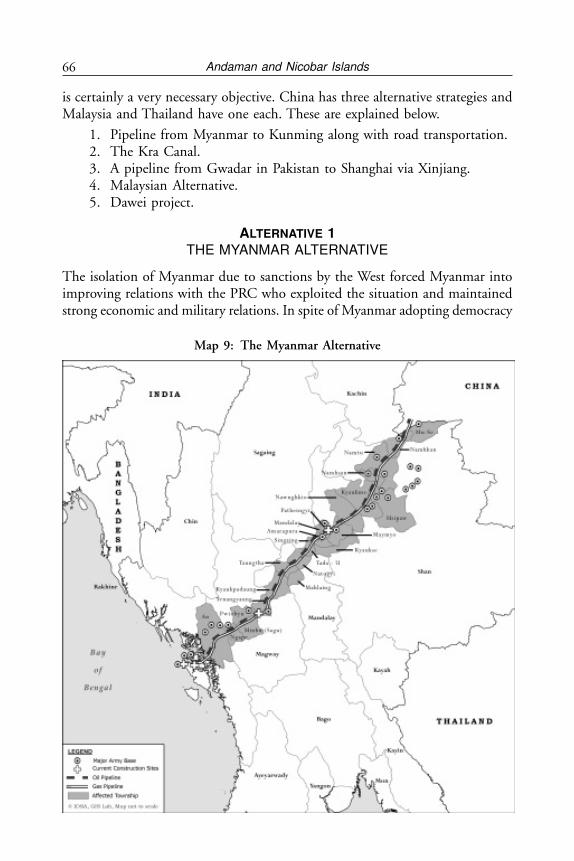
Andaman and Nicobar Islands66
is certainly a very necessary objective. China has three alternative strategies andMalaysia and Thailand have one each. These are explained below.
1. Pipeline from Myanmar to Kunming along with road transportation.2. The Kra Canal.3. A pipeline from Gwadar in Pakistan to Shanghai via Xinjiang.4. Malaysian Alternative.5. Dawei project.
ALTERNATIVE 1THE MYANMAR ALTERNATIVE
The isolation of Myanmar due to sanctions by the West forced Myanmar intoimproving relations with the PRC who exploited the situation and maintainedstrong economic and military relations. In spite of Myanmar adopting democracy
Map 9: The Myanmar Alternative
67Importance of Straits of Malacca
and relations with China getting diluted, the Chinese investment both in civiland military spheres will continue to have a stranglehold over it. It also appearsthat Myanmar is looking to get out of China’s embrace and stranglehold as morealternatives open up. However, as Myanmar moves towards democracy, distancingitself from China, Chinese co-operation with Myanmar is in trouble. AlreadyMyanmar has called off the construction of a huge dam in the north Kachinstate due to local protests. This hydel project would have benefitted Yunanprovince of China with electricity. India, which was very close to Myanmar inNehru’s days became indifferent to the Military Junta and lost out to China.When most of the world was not talking to Myanmar it was China thatconsolidated its hold over Myanmar. It may be recalled that it was India’s Nehruwho requested Chinese Premier Chow En Lai to finalise the border withMyanmar, which they did along the McMahon line in 1961. But now India’sdiplomacy has to work harder to make up for the lost time.
Although, bilateral trade between China and Myanmar exceeds US$ 1.4billion, Chinese exports to Myanmar are typically manufactured goods like steeland textile products and imports from Myanmar include raw materials like naturalrubber, raw wood and now oil and gas. China’s main interest is in Myanmar’sextensive oil and natural gas reserves and setting up a pipeline from Bay of Bengalto Kunming in China. It is, therefore, one of the chief partners of the Myanmareseregime in the project to renovate and expand the Sittwe seaport in the Bay ofBengal and has received rights to develop and exploit natural gas reserves in theArakan region. China extensively aided the construction of strategic roads alongthe Irrawaddy River trade route linking Yunnan province to the Bay of Bengal.China has already signed up with Myanmar for construction of two pipelinesfrom Sittwe in Myanmar to Kunming in Yunnan Province with an estimatedcost of around US$ two billion. Such a pipeline from Myanmar to Yunnan isvery appealing to China because oil tankers from Middle East and Africa wouldbe able to bypass the Straits of Malacca.
Chinese firms have been involved in the construction of oil and gas pipelinesstretching 2,380 km from Kyankphyu Deep Sea Port in Myanmar’s Arakan coastto Kunming in China’s Yunnan Province. China National Offshore OilCorporation (CNOOC) and the China National Petroleum Corporation (CNPC)hold important contracts on upgrading Myanmarese oilfields and refineries andsharing of production. Petro China has completed the gas pipeline from the Shweoil field off the coast of the Rakhine State leading to Yunnan, accessing andexploiting an estimated 2.88 to 3.56 trillion cubic feet of natural gas. The projectis expected to deliver US$ 30-50 billion to the Myanmar Government in 30years. Initially this deal was offered to India with a pipeline through Bangladeshbut since India and Bangladesh could not agree to the pipeline, China got thebetter of it.16 A parallel pipeline is also part of the project–designed with anannual capacity of 22 million tonnes of oil and 12 million cubic metres of gas
Andaman and Nicobar Islands68
when completed. The pipeline will therefore provide both gas and oil fromMyanmarese wells as well as pump up oil from ships coming into Myanmareseports to Kunming in Yunan, bypassing the Straits of Malacca.17
China is also the most important supplier of military aid to Myanmar andmaintains extensive strategic and military cooperation. Since 1989, when no othercountry was prepared to supply anything to China due to sanctions, Chinaexploited the isolation of Myanmar and supplied Myanmar with jet fighters,armoured vehicles and naval vessels and trained Myanmarese Army, Air Forceand Naval personnel. Access to Myanmar’s ports and naval installations providesChina with strategic influence in the Bay of Bengal, in the wider IOR and inSoutheast Asia. China has developed a deep-water port in Kyaukpyu in the Bayof Bengal. It has also reportedly built an 85-metre jetty, naval facilities and majorreconnaissance and Electronic Intelligence (ELINT) systems on the Great CocoIsland, located 18 km from the northern most islands in the Andaman group,giving China capabilities to monitor India’s military activities, including missiletests. China has been assisting in constructing a naval base in Sittwe, a strategicallyimportant sea port close to eastern India’s largest city and port, Kolkata. Chinaalso funds road construction linking Yangon and Sittwe, providing the shortestroute to the Indian Ocean from southern China.
China and Russia also vetoed a UNSC resolution designed to punishMyanmar. In recent years, however, China has shown a lack of willingness toback the Myanmar Government and has attempted to destabilise the politicalsituation in Northern Myanmar. This is an indication of strained relations betweenthe two countries.
Post the democracy movement in recent years, Myanmar has moved to developstrategic and commercial relations with India, with whom it shares a very oldrelationship, having been a part of India under the British. Increasing trade andmilitary cooperation with India, developing bilateral relations with Japan andwith ASEAN shows a desire in Myanmar’s foreign policy to avoid excessivedependence on China. Myanmar joined ASEAN as a member in 1997.
After the Kokang incident in northern Shan state of Myanmar in August2009 which attracted international media interest, relations between Myanmarand China have soured. It is clear that Myanmar was prioritising internal conflictsover its ties with China; however some Chinese analysts, such as Shi Yinhong,18
played down the relationship between Myanmar and China, saying “They’re notgreat friends. They don’t listen to what China says.” China had urged Myanmarto ensure the stability of the border area and protect the interests of its citizensin Myanmar. The Myanmarese Foreign Ministry later apologised to China aboutthe incident, but also ran a story on the Dalai Lama in the government newspaperthe Myanmar Times, the first mention of him in the state controlled Myanmaresemedia for 20 years. Chinese officials were said to be “furious” and “extremely

69Importance of Straits of Malacca
upset” over not being forewarned about the offensive on the border. It may berecalled that while Myanmar was first to recognise communist China in 1959,it broke its diplomatic relations in 1967 when it suspected it interfering in itsinternal affairs and encouraging a communist movement in Myanmar.
It is in India’s interest to ensure that the traditional close relationship withMyanmar is restored and the Chinese influence which grew due to sanctionsimposed by rest of the world, are nullified. This means that Indian diplomacyhas to work hard to convince the US to lift all the sanctions against Myanmar.They also have to work hard to ensure decline of Chinese influence over Myanmarand bring back India as a favoured neighbour.
ALTERNATIVE 2KRA CANAL
Even though distance saved by the Kra Canal in comparison with the presentroute of Straits of Malacca, is not so significant, nevertheless according to acomputerised picture, ships could save some 28 to 40 hours when travellingthrough the Kra Canal.
Straits of Malacca
Traffic Estimates(Ships Over 1,000 DWT)
1972 15,000 (MAX. 20,000) - TAMS
1993 42,000 (Inter-Reg. only)U.S. CNA
1997 92,000 U.S. CNA, Lloyds
1999 103,000 U.S. CNA, Lloyds
Note that the kra canal capacity at 80 per cent of allowable density is 110,000ships per year per lane.
China’s second alternative to bypass the Straits of Malacca is to help buildan alternative canal to Straits of Malacca. This can be done by reviving the oldproject of Kra Canal in Thailand. This proposed canal which will cut throughKra Isthmus of southern Thailand will be about 44 km long and will link directlyto the Indian Ocean avoiding the Straits of Malacca and also cutting distance toChinese Ports. However, with rocky land of up to 75 metres above the sea levelthe engineering and labour requirements will be huge. The project was approvedby the Thai Senate in 2007 but is stalled due to environment concerns. TheSingapore Government is concerned as they would lose their pre-eminent position.The US had also shown its concern amid the growing influence of the Chinese
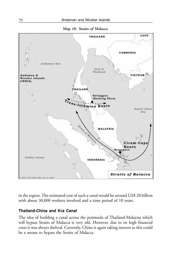
Andaman and Nicobar Islands70
in the region. The estimated cost of such a canal would be around US$ 20 billionwith about 30,000 workers involved and a time period of 10 years.
Thailand-China and Kra Canal
The idea of building a canal across the peninsula of Thailand-Malaysia whichwill bypass Straits of Malacca is very old. However, due to its high financialcosts it was always shelved. Currently, China is again taking interest as this couldbe a means to bypass the Straits of Malacca.
Map 10: Straits of Malacca
71Importance of Straits of Malacca
Based on a report prepared appearing in Washington Times, China’s strategyof underwriting construction of the canal across the Kra Isthmus, complete withChinese port facilities and refineries, is part of its “string of pearls” strategy offorward bases and energy security. The Chinese plan called for construction over10 years, employing roughly 30,000 workers and costing between US$ 20 to 25billion.
In so far as India is concerned the distance from Great Nicobar Islands to thewestern tip of Kra canal would be about the same and the shipping route willstill go past Nicobars. However, India should take up diplomatically with Thailandtheir concern as Chinese involvement would be detrimental to Indian interest.India should have no objection if Indian engineering companies and labour isinvolved. It may be pointed out that Suez Canal opened in 1869 and is 193 kmlong while Panama Canal opened in 1914 and is about 82 km long. A 44 kmlong canal as an alternative to Malacca is well within the realm of possibility. Thecost benefit analysis and its use has not been worked out in detail but even if 25per cent of the existing traffic of ships that use the Straits of Malacca use this andpay for it, it can become self-sustaining and economically viable.
Thailand has also proposed an alternative to Straits of Malacca. Instead ofKra Canal, it has proposed a pipeline running underground across the Isthmus.Such a pipeline will benefit not only China but other countries like Japan, SouthKorea etc. However, high costs and political issues have not made it possible forthis pipeline to see the light of day yet.19
ALTERNATIVE 3GWADAR PORT
Chinese alternative to Straits of Malaccas: Gwadar Port in Pakistan
The last and third alternative by China to bypass the Straits of Malacca is tobuild a pipeline and a road from Gwadar Port in Balochistan in Pakistan all theway up to Kashgar in Xingjiang, China.
In August 2001, the Chinese and Pakistan Governments signed a financingagreement for building the Gwadar Port with US$ 198 million, a preferentialloan while Pakistan raise a US$ 50 million. Gwadar Port built by China is about460 km west of Karachi and only 75 km east of its border with Iran and next tothe busy Straits of Hormuz. The first phase was completed in 1999 but it becameoperational only in 2008 with the first ship to dock being from Canada. A secondphase is on the anvil.
The port was being run by Singapore’s Port Authority (PSA) Internationalwhich won a contract for 30 years in which China did not take part. However,the project was not making money and PSA has got out of it. China has nowtaken over the running of the port through one of its Public Sector Undertakings(PSU’s), the Chinese Overseas Port Holdings Company (COPHC). China has
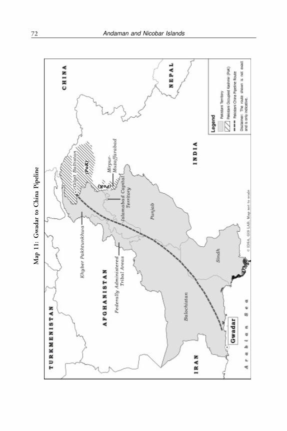
Andaman and Nicobar Islands72M
ap 1
1:
Gw
adar
to
Ch
ina
Pip
elin
e
73Importance of Straits of Malacca
also been wanting to build a pipeline from Gwadar Port to Xingjiang along the1,300 km Karakoram Highway built by them through Kashmir, Hunza valleyand Gilgit which is under occupation of Pakistan. This pipeline can carry thecrude oil from Gulf and African States all the way to China. The COPHC hastaken over and has assured to invest US$ 750 million immediately to furtherimprove the infrastructure.20 This may also perhaps become a Chinese navalport as it has strategic importance. 60 per cent of China’s crude supply comesfrom the Gulf countries.
With special relations between China and Pakistan, India can expect a pipelineand a tunnel from Gwadar to Xingjiang to come up which will help bypassMalacca for their oil shipment. During the visit of Prime Minister of PakistanMr. Nawaz Sharif in 2012, an agreement was signed between the two governmentsto provide a Pakistan-China Economic Corridor with a 200 mile long tunnelconnecting Pakistan Gwadar Port with Kashgar in Xinjiang in North West China.The corridor will pass through Pakistan Occupied Kashmir (POK). It is notclear whether the Government of India has lodged a protest with China on usingthe part of Kashmir with Pakistan.21
Once again India has watched helplessly as China walks away by constructinga pipeline over territory in Gilgit. This is similar to Pakistan giving away a pieceof Kashmir to China in its border settlement in 1963 (a fact which is mentionedin the Sino-Pakistan Agreement of 1963). But the pipeline has technical andsecurity issues and will take time to come up.
ALTERNATIVE 4MALAYSIAN ALTERNATIVE
A fourth alternative has also come up with the announcement by Malaysia ofconstructing a pipeline across northern Malaysia for about US$ seven billionbetween Bay of Bengal and South China Sea. This 300 km or 185 miles longpipeline will allow ships to divert a third of all oil now being carried throughStraits of Malacca. Rahim Kamil Sulaiman, Chairman of the project, announcedin May 2007, that the work on it will commence in 2008 and finish by 2014.Trans-peninsula Petroleum signed an agreement with a Malaysian companyRanhill Engineers and Constructors for design and construction in presence ofthe Malaysian Prime Minister Abdullah Ahmed Badawi and the IndonesianPresident Susilo Bambang Yudhoyono. It was also proposed to have two refineriesat Kedah where the crude oil from Gulf would be refined. Refined oil will thenbe loaded on to ships bound for China and Japan with a combined refiningcapacity of 450,000 barrels a day.
So far nothing further has been heard of this project. If it comes up it willimpact Singapore which is also a political and economic rival of Malaysia. If thescheme is successful it will carry about 20 per cent of the oil that passes throughthe Straits.22
Andaman and Nicobar Islands74
ALTERNATIVE 5
Dawei Project is a proposal coming from Thai Prime Minister YingluchShinawatra to develop a Chennai-Dawei corridor which was discussed during avisit to India. This is another alternative to Straits of Malacca and is proposedwith Thailand in collaboration with Myanmar as Dawei is on the shores ofAndaman Sea in southern Myanmar close to the Thai border. The project is notbased on cutting a canal but building a land based transport corridor runningacross Myanmar and Thailand. This project will create an overland system oflogistics along with a massive industrial complex. Dawai DevelopmentCorporation has already been set up with controlling stake of an Italian companycalled Ital-Thai. An agreement has already been signed between the MilitaryGovernment of Myanmar for development of the complex in 2010. However,the new Democratic Government of Myanmar has already overruled the Ital-Thai plans to build a coal fired plant on environmental grounds. India has alsosignalled its interest in the project.23
The Chinese Malacca dilemma is causing the government of China to findalternatives. While the Myanmar alternative is secure, the other two alternativesof Kra Canal and a pipeline through Pakistan are still not clear. The Gwadaralternative faces many technical problems although Pakistan and China havesigned up for a 200 mile long tunnel at a cost of US$ 18 billion. All thesealternatives will mitigate a part of the Chinese Malacca dilemma. In addition,China is also building oil and gas pipelines across Russia. However, the Chineseexport dependence is also mainly ship based and Straits of Malacca take a verylarge share of it (China has already started railway based exports to Europe upto Germany). Any impact on this will impact Chinese economy adversely.
All these projects raise tremendous technological challenges and viability issues.The gas and oil pipeline from Myanmar to Kunming is already operational. Sincethe Government of Myanmar has already signed an agreement on March 27,2007 on the issue of oil and gas pipelines, with a planned expenditure of US$1.5 billion and one billion respectively, of which one of the pipelines has alreadystarted and the other is expected to be completed shortly. China NationalPetroleum Corporation (CNPC) holds 50.9 per cent stake while the rest is ownedby Myanmar Oil and Gas Enterprise.
Taking into account the China-Myanmar oil and gas pipelines, China-Pakistan oil pipeline and also China-Russia and China-Kazakstan oil pipelinewith their capacities, Chen Shaofeng,24 has come to the conclusion that even ifall these operate at full capacity, they will meet China’s requirement by 26 percent only and, therefore, China will still need to depend heavily on the Straits ofMalacca.
Chen Shaofeng goes on further to state that the Malacca Dilemma for Chinamakes it go in for a naval build up to preserve its SLOC. Further, as China’s
75Importance of Straits of Malacca
trade and imports grow it needs a globally capable navy to keep its trade protected.At the same time, Chen concedes that China’s military build up is likely to leadto an arms race as other countries in the Asia-Pacific are not willing to see thepower balance being broken and lack of transparency by China may appear tobe like a threat to world security. US in particular will not allow it and othercountries will follow. For example, Japan has already embarked on its quasi aircraftcarrier as the Japanese constitution does not allow owning of an aircraft carrier.US might use the threat of denial i.e. denying China access to its crucial SLOCS,especially its imports of oil through South China Sea.
In so far as India is concerned, the Gwadar Port and pipeline project ofPakistan and China are most disturbing. This is because close relations of Pakistanand China in military matters makes Gwadar Port a near certain Chinese navalfacility. Also, use of POK by China for purposes of a pipeline, even against thewishes of local population, is unfortunate. India’s protest for use of POK is somild that it is not even felt. The Myanmar pipeline to China is already a reality.As long as Myanmar does not offer to the Chinese navy port facilities, there islittle harm to India. The other three proposals of Kra Canal, the Malaysian andDawei-Chennai proposal are vague and at this stage cannot be taken seriously.
The fact that China is seeking alternatives to the Straits of Malacca confirmsthat China has realised that its rise is being looked at with fear, doubt and hostility.Further, its major claim to the South China Sea followed by military action ismaking countries in South East Asia hostile to it. Its crude methods of use offorce to seek what it might perceive to be its rightful due, but is not acceptedotherwise is reminiscent of its military occupation of Tibet and is not payingdividends. India needs to leverage this opportunity with use of hard and softpower in the Andaman Sea/Bay of Bengal/South China Sea.
NOTES
1. Shinzo Abe, Mint, January 01, 2012.2. Sam Bateman, Catherine Zara Raymond and Joshua Ho, “Safety and Security in Malacca
& Singapore Straits”, Policy Paper, Maritime Security Programme, Institute of Defence &Strategic Studies, Singapore, 2006.
3. Michael Jarocki, “India’s Strategy Towards Strait of Malacca”, Global Strategies, April, 1,2012.
4. “Piracy and Armed Robbery in Straits of Malaccas: A Problem Solved?” National War CollegeReview, at www.humansecuritygateway.com/documents/nwrc/piracy&robbery.
5. R. Pulugan, “Taking on Regional Piracy Calls for New Directions in Straits of Malaccas”,January 01, 2010.
6. See Air Marshal Dhiraj Kukreja, “Security Challenges of India: Andaman & Nicobar Islands”,Indian Defence Review, January–March, 2013.
7. Nirmala Sitharaman, Asian Age, June 26, 2011.8. Aparajit Biswas: “Small Arms & Drug Trafficking in Indian Ocean Region”, Working Paper
No. 4, Centre of African Studies, University of Mumbai.9. See Asian Age, September 28, 2011.
Andaman and Nicobar Islands76
10. Wo Kong, “China’s quest for energy security,” Energy Resources Environment Programme,SAIS, Johns Hopkins University; Georgia Institute of Technology.
11. Robert D. Kaplan, Monsoon: The Indian Ocean and the Future of American Power, RandomHouse, New York, p. 125.
12. China-South East Asian Relations: Trends, Issues and Implementation for the United States,Congressional Research Services, Library of the Congress, April, 2006.
13. Brahma Chellaney, Asian Juggernaut: The Rise of China, India and Japan, HarperCollins,2006, p.145.
14. Non Alignment 2.0 is a product of collective deliberations, debate and report writing involvingan independent group of analysts and policy makers namely Sunil Khilnani, Rajiv Kumar,Pratap Bhanu Mehta, Lt. Gen Prakash Menon (Retd), Nandan Nilekani, Srinath Raghavan,Shyam Saran and Siddharth Varadarajan.
15. International Journal of Chinese Studies, 1(1), January 2010, pp. 1-24.16. C. Raja Mohan Samudra Manthan: Sino-Indian Rivalry in the Indo-Pacific, CEIP, Washington
D.C., 2012, pp. 121-123.17. Economic Times, July 30, 2013, p. 13.18. Shi Yinhong, Professor of International Relations, Centre for American Studies, Renmin
University of China.19. C. Raja Mohan, no. 16,20. Hindustan Times, February 02, 2013, p. 17.21. Indian Express, July 06, 2013.22. International Herald Tribune, May 29, 2007.23. C. Raja Mohan: Indian Express, January 26, 2012.24. Chen Shaofeng, “China’s Self-Extrication from the Malacca Dilemma”, International Journal
of China Studies, 1, January 2010, pp. 1-24.
77The International Law of the Sea and India’s Maritime Legislative History
CHAPTER 4
The International Law of the Sea and India’sMaritime Legislative History
India is fortunate in having all its legislation with regard to maritime issues andboundaries in place except for with Pakistan and Bangladesh. With Bangladeshthe maritime boundaries are being settled in arbitration and hopefully will beresolved soon. With other countries India has settled all the maritime boundaries.The following gives a detailed description of India’s maritime issues:
DEVELOPMENTS TILL 1965
Traditionally, the international law of the sea had come to be based on the basicprinciple of “freedom of the seas”. Beyond the narrow coastal strip of territorialwaters, the seas could be freely used by all nations for fishing and for navigation.Coastal states used to be content with exclusive rights in their narrow belt ofterritorial waters.
US was the first to extend its jurisdiction over coastal seas. With improvedtechnology, the discovery of petroleum and natural gas in the shallow waters ofthe continental shelf led the US to issue the Truman Proclamation in 1945, whichclaimed sovereign rights over the resources of the continental shelf adjacent to itscoast. Around the same time, coastal states found that the fishing areas neartheir coasts were being poached by larger and better equipped fishing ships ofdistant foreign states. Both these developments, combined with the emergenceof newly independent states after the decolonisation of Asia and Africa, led to aspate of unilateral claims by the coastal states to extend national jurisdiction overlarge adjacent sea areas to protect their fishery resources.
POST-INDEPENDENCE INDIA
On attaining independence in 1947, India was quick enough to realise theimportance of the sea and proclaimed the traditional territorial sea of three miles.But by 1955, in view of the international developments, India issued fourpresidential notifications to safeguard its maritime interests:
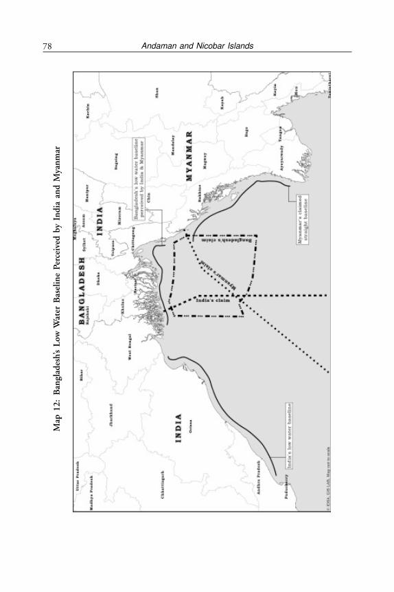
Andaman and Nicobar Islands78M
ap 1
2:
Ban
glad
esh’
s L
ow W
ater
Bas
elin
e P
erce
ived
by
Ind
ia a
nd
Mya
nm
ar
79The International Law of the Sea and India’s Maritime Legislative History
(a) On August 30, 1955, India claimed full and exclusive sovereign rightsover the seabed and subsoil of the continental shelf adjoining the coastbut beyond territorial waters. Neither the depth nor the distance fromthe coastline was indicated.
(b) On March 22, 1956, India claimed territorial waters of six miles fromappropriate baselines.
(c) On November 29, 1956, India claimed a conservation zone for fisheriesup to a distance of one hundred miles from the outer limit of territorialwaters.
(d) On December 3, 1956, India claimed a contiguous zone.
Several other developments were also taking place. The USA and the SovietUnion were unable to agree on the width of territorial waters—the Soviet Unionwanted 12 miles whilst the USA wanted only three miles. Technologicaldevelopments in the industrialised West began to make it possible to extract oiland gas from the seabed. The newly independent nations of Asia and Africabegan to feel that the International Law of the Sea would be exploited to theirdisadvantage. To sort out all these matters, the first UNCLOS I was convenedin 1958.
UNCLOS I—1958
UNCLOS I was able to codify the traditional law. It adopted what came to beknown as the Geneva Conventions on the Law of the Sea. Its principles were:
- The freedom of the seas as long conceived.- The sovereignty of coastal states in the territorial sea.- The ancillary physical, customs, sanitary and immigration rights of
coastal states in a contiguous zone.- The acceptance by UNCLOS I of the Continental Shelf Convention.
This enabled the countries bordering the North Sea to divide the sea area forextracting oil and gas.
The UNCLOS I participants remained divided on several issues:
- The rights of coalitions of coastal states, land locked states andarchipelagic states.
- Certain states contested the rights of passage through straits used forinternational navigation like the Straits of Gibraltar, Hormuz andMalacca.
- Land based mineral producers tried to carve out for themselves as muchas they could of the newly found seabed mineral resources.
Andaman and Nicobar Islands80
UNCLOS I completely failed to agree on:
- The precise width of the Territorial Sea (three miles or 12 miles) andthe extent of the Exclusive Fisheries Zone (EFZ).
- The prior authorisation and/or notification of the passage of foreignwarships through the territorial sea of a coastal state.
The Second Conference, UNCLOS II, was therefore convened in 1960 toresolve these issues.
UNCLOS II—1960
UNCLOS II attempted to extend the jurisdiction of coastal states over territorialwaters to six miles, with an additional six miles as an EFZ. This failed to gainthe required two thirds majorities for its acceptance.
After UNCLOS II failed to achieve agreement on the width of the territorialsea, many countries unilaterally extended their offshore jurisdiction. The SouthAmerican countries reaffirmed their earlier claim of their territorial watersextending 200 miles from the coast. African states like Nigeria, Congo, Mauritiusand Ghana also extended their territorial sea to distances much beyond 12 miles.
Passage of Warships through the Territorial Sea
At UNCLOS I, India had proposed that the passage of foreign warships throughthe territorial sea of a coastal state should be subject to prior authorisation andnotification to the coastal state. As this requirement was not accepted and thereforenot included in the 1958 conventions on the territorial sea and the contiguouszone, India declined to ratify all four Geneva Conventions. In subsequent years,India resiled from this position. As a growing maritime nation interested in thefreedom of navigation both for itself and the international community, Indiasought only prior notification for the innocent passage of foreign warships throughterritorial waters.
DEVELOPMENTS AFTER 1965
India’s Extension of Territorial Waters
On September 12, 1967, India extended its territorial waters to 12 miles. Thiswas largely a reaction to Pakistan’s extension of her territorial waters from threeto 12 miles, rather than an act of maritime policy.
The Seabed Committee
During the 1960s political, technological, economic and naval developmentsbegan to change the situation. Advances in seabed exploitation technology madeit possible to exploit the seabed much beyond a depth of two hundred metres,
81The International Law of the Sea and India’s Maritime Legislative History
thereby rendering the 1958 Conventions outmoded. The deployment ofSubmarine Launched Ballistic Missiles and worldwide apprehensions of acompetitive scramble to achieve predominant control over the seabed led theUN to discuss the need to evolve means for the peaceful use of the oceans. In1968, the UN General Assembly constituted a 42 member “Seabed Committee”on the peaceful use of the seabed.
In December 1970, the General Assembly adopted the “Declaration ofPrinciples” governing the Seabed, the ocean floor and the subsoil thereof, beyondthe limits of national jurisdiction. The Declaration stated that these areas andtheir resources are the common heritage of mankind and shall be subject to aninternational regime as established by an international treaty.
Seabed Mining
India’s interest in the mining of polymetalic nodules from the seabed derivedfrom its long term strategy for metals like nickel, cobalt, copper and manganese.In the early 1970, the Government of India had initiated a programme ofscientific investigation and evaluation of the manganese nodule resources in theIndian Ocean.
Offshore Oil and Gas
By the early 1970’s, India had discovered oil and gas in Bombay High andpromising fields were being forecasted in the Godavari, Krishna and Palk Baybasins, as also gas in the Andaman Offshore.
India has been quite meticulous in taking care of its maritime border, especiallyin the east. India’s maritime legislative history is as follows:
MARITIME ACT, 1976
On August 25, 1976 India passed the Maritime Zones Act which claimed a 12mile territorial sea, a 24 mile contiguous zone, a 200 mile EEZ and a continentalshelf up to 200 miles or the outer edge of the continental margin, whichever isgreater.
Soon after this Act, a committee was set up to consider the type of force thatshould be created to enforce compliance with its provisions. Three optionsemerged:
I. To entrust this responsibility to the marine wing of the MoF. This optionwas not pursued as the functions were too onerous.
II. To set up a separate Coastal Command, as a part of the navy, to overseethese functions. This option was seriously considered since it would avoidthe expenditure of raising and maintaining a separate armed force. TheMEA however felt that patrolling of the EEZ and protection of national
Andaman and Nicobar Islands82
assets was a peace time role for which defence assets should not be used.III. To set up a separate armed force of the Union, along the lines of the US
Coast Guard. This option was finally chosen, as it avoided the navybeing distracted from its primary role of preparing for hostilities.
An interim Coast Guard was constituted on February 1, 1977, which operatedunder the aegis of the navy until August 18, 1978. A permanent Coast Guardwas constituted as an armed force of the Union on August 19, 1978. The CoastGuard Act 1978 requires the Coast Guard to:
(a) Ensure the safety and protection of offshore terminals, installations andother structures and devices.
(b) Provide protection to fishermen, including assisting them when in distressat sea.
(c) Protect the marine environment by preventing and controlling marinepollution.
(d) Assist the customs in anti-smuggling activities when patrolling the seasbeyond Indian territorial waters.
(e) Enforce the Maritime Zones Act of 1976.(f ) Take measures for the safety of life and property at sea.(g) Collect scientific data.
The Coast Guard thus became the principal agency for enforcing all nationallegislation in the Maritime Zones of India, working in close liaison with otherGovernment authorities to avoid duplication of effort.
During hostilities, India’s Coast Guard would function under the overalloperational command of the navy as is done by other Coast Guards of the world.
UNCLOS III—1973-82
With a view to establishing an equitable international regime for the exploitationof seabed resources, the UN General Assembly (GA) convened the thirdconference, UNCLOS III in 1973.
It took UNCLOS III nine years of discussions to finally adopt the Conventionon April 30, 1982. However, this convention took 12 years to formally comeinto force on November 16, 1984. UNCLOS III aimed to define an agreed setof rules to govern the use of the seas which would strike a fair balance between:
(a) Those who considered that a coastal state should have no rightwhatsoever over the living resources of the seas beyond a territorial seaof 12 miles; and
(b) Others who maintained that a coastal state should have full or limitedsovereignty over the sea and its resources out to an (EEZ) of 200 nm
83The International Law of the Sea and India’s Maritime Legislative History
The acceptance of this concept of the EEZ was a landmark contribution ofUNCLOS III.
At UNCLOS III, India’s stand was that as a developing country centrallylocated in the Indian Ocean, with a coastline of over 64,000 km, its basic nationalinterests were:
(a) To obtain assurance of smooth and free navigation though traditionallyused waters and straits used for international navigation.
(b) To achieve archipelagic status for the Andaman & Nicobar Island groupand the Lakshadweep Island group which between them, comprised over1,280 islands and islets.
(c) To protect essential strategic and security interests in the waters aroundits coast.
(d) To secure the free mobility of naval war ships.(e) To preserve the marine environment in the sea areas adjacent to its coast,
because the channels of navigation passed near its long coastline.(f ) To regulate within its EEZ, the conduct of marine scientific research by
foreign research agencies.
India advocated from the baselines, a territorial sea of 12 miles, an EEZ of200 miles and a continental shelf to the outer edge of the geological continentalmargin. India also made specific proposals on the requirement of prior notificationfor warships passing through the territorial sea, enlargement of safety zones aroundoffshore oil rigs, designation of special areas for the protection of the resourceslocated therein (as for example the coral lagoons in the Lakshadweep where tankerscould run aground) and several other proposals.
THE OUTCOME OF UNCLOS III—THE 1982 CONVENTION
ON THE LAW OF THE SEA
The 1982 Convention on the Law of the Sea met most of India’s interests. Itadopted:
• 12 miles as the uniform limit for the width of the territorial sea.• A 200 miles EEZ, within which the coastal state exercises sovereign rights
and jurisdiction for certain specified economic activities.• A continental shelf extending to the outer edge of the continental margin,
to be delimited with reference to either 350 miles from the baselines ofterritorial waters or 100 miles from the 2,500 metre isobaths.
• Regimes for the abatement and control of marine pollution, for marinescientific research, for the international seabed area and for unimpededtransit passage through straits used for international navigation.
• The 1982 Convention included India as one of the four states namedas ‘pioneer investor’ for seabed mining. On August 17, 1987, India

Andaman and Nicobar Islands84
became the first state to be so registered, after having fulfilled the criteriastipulated in the convention.
There were several areas where India’s stand was not accepted. The major oneswere:
Passage of Warships through the Territorial Sea
There was vehement opposition from the US and the Soviet Union to priornotification before warships transited through territorial waters, on the groundsthat it would seriously jeopardise their strategic and security interests. There istherefore no provision in the 1982 UNCLOS requiring prior notification orauthorisation for the passage of foreign warships through the territorial watersof a coastal state. By 1977, Pakistan, Bangladesh, Sri Lanka and Myanmar hadall unilaterally promulgated that prior authorisation and notification was requiredfor the passage of foreign warships through their respective territorial seas.
India’s Maritime Zones Act 1976 also requires foreign warships to give priornotification for passing through India’s territorial waters and enjoins all submarinesand other underwater vehicles to navigate on the surface and show their flagwhile passing through these waters.
Archipelagic Status for the Andaman & Nicobar Islands
The convention granted the status of an archipelago only to those groups ofislands that were political entities by themselves as for example Indonesia, thePhilippines and the Maldives. This was because of fear of interference with thefreedom of navigation through archipelagic waters that might be created if theoff-lying islands of continental coastal states were to be granted archipelagic status.For example, the distance between the Andaman group and the Nicobar groupof islands is 76 miles. If archipelagic status had been granted to these groups ofislands, India would have had full regulatory control over the navigation of shipspassing through the 10 Degree Channel, which would then have been part ofIndia’s archipelagic waters, and therefore subject to the restricted regimes ofarchipelagic sea lanes passage.
Enlarged Safety Zones for Offshore Installations
The UNCLOS I Continental Shelf Convention had provided for a safety zoneof 500 metres around artificial islands, installations or structures on thecontinental shelf. India’s view at UNCLOS III was that this zone was inadequate,considering the time that a huge super tanker takes to come to a stop. Indiatherefore advocated enlarged safety zones. The suggestion did not receive adequatesupport. A provision was, however, incorporated in the 1982 Convention thatif authorised by generally accepted international standards or as recommended
85The International Law of the Sea and India’s Maritime Legislative History
by the competent international organisation, then a coastal state may promulgatesafety zones larger than 500 metres.
India’s gains after the 1982 UNCLOS—Apart from the benefits of an agreedLaw of the Sea, India gained in the following significant areas:
(a) India’s EEZ became the 12th largest in the world. The extension of theEEZ to 350 miles or 100 miles beyond the 2500-metre isobath addedtwo million square km to India’s jurisdiction.
(b) As a result of UNCLOS III India was able to gain 0.66 sq km of EEZwhich is about of 1/3rd of India’s EEZ. According to SwaminathanAnklesaria Aiyer, India has been known to have massive deposits ofmethane hydrates. An Indo-US Scientific Joint Venture of 2006 exploredfour areas Kerala-Konkan Basin, Krishna-Godavari Basin, the MahanadiBasin and the Seas of Andaman Islands. The Andaman achieved thickestever deposits at 600 meters below the sea bed. The potential of findinghydro-carbons in the EEZ of these islands seems possible and needsgreater exploration.1
(c) Pursuant to the ‘pioneer investor’ status, the International SeabedAuthority (ISA) allotted to India a 150,000 square km mine site in thecentral Indian Ocean for the seabed mining of poly-metalic nodules.The richest area at this site has a density of 21 kilograms of nodules persquare metre.
Chinese have also been allotted 10,000 sq km in the Indian Ocean by the ISAto explore seabed for ore for a period of 15 years.
MARITIME BOUNDARIES
India has maritime boundaries with five states located opposite to it (Sri Lanka,the Maldives, Myanmar, Indonesia, Thailand) and two adjacent states (Pakistanand Bangladesh).
Maritime boundary agreements were amicably concluded with:
(a) Sri Lanka in 1974 and 1976.(b) Indonesia in 1974.(c) The Maldives in 1976.(d) Thailand and Indonesia, on the tri-junction point, in 1977.(e) Myanmar in 1982.
Maritime boundary agreements with the adjacent states of Pakistan andBangladesh have yet to be concluded. Meetings have been held with Bangladeshsince 1976 and with Pakistan since 1986.
Andaman and Nicobar Islands86
India’s Maritime Border with its Neighbours
Except for Bangladesh, India has settled its maritime boundaries in the Bay ofBengal with Indonesia, Thailand, Malaysia, Myanmar and Sri Lanka. Followingis a brief description of its maritime borders in the Bay of Bengal. India hasnine boundary agreements with its neighbours.
There was a lot more bonhomie between India and Indonesia in the Sukarnodays when India had become very close to Indonesia but the goodwill got dissipatedover time. There were differences between India and Indonesia over Andaman &Nicobar Islands which is now a settled issue. Indonesia claimed archipelagic statusand adopted archipelagic baselines that were accepted by the Third UN Law ofthe Sea Conference. Thus, the Indonesian territorial sea, EEZ and continentalshelf are all measured from archipelagic baseline and therefore the two countries’claims on the continental shelf overlapped in the Andaman Sea and the Bay ofBengal. However, India was able to settle its continental shelf boundary withIndonesia by two separate agreements—the first in 1974 on delineation of thearea between Great Nicobar and Sumatra and the other in 1977. While the firstagreement settled the issue of the continental shelf on modified equidistantprinciple, the second agreement of 1977 was concerning the EEZ and alsodetermined a tri-junction point following which India, Indonesia and Thailandsigned a boundary treaty to determine a common tri-junction point in theAndaman Sea. An agreement between the Government of the Republic of Indiaand the Government of the Republic of Indonesia relating to the delimitation ofthe continental shelf boundary between the two countries was signed on August8, 1974 and came into force on December 17, 1974.
This was a major difference between the Indonesian perception of theirmaritime boundaries and that of India which was reconciled. The 1974 Agreementbetween the Government of the Republic of India and the Government of theRepublic of Indonesia on the extension of the 1974 continental shelf boundarybetween the two countries in the Andaman Sea and the Indian Ocean came intoforce on December 22, 1980.
India and Thailand
In 1978 the Government of India and the Kingdom of Thailand signed anAgreement delimiting the seabed boundary. This was based on the determinationof the tri-junction point between India, Thailand and Indonesia on the basis ofthe UNCLOS III Agreement between the Government of the Kingdom ofThailand and the Government of the Republic of India on the delimitation ofsea-bed boundary between the two countries in the Andaman Sea signed onJune 22, 1978 and which came into force in December 15, 1978.
87The International Law of the Sea and India’s Maritime Legislative History
India-Myanmar
Post India-Thailand Agreement of 1978 India started negotiations with Burma(now Myanmar) and after considering their national legislation on December23, 1986 India reached an Agreement with Myanmar delimiting the boundaryin the Coco Channel, the Andaman Sea and the Bay of Bengal based onprovisions of UNCLOS.
India and Bangladesh
Indo-Bangladesh maritime issues are little more complicated. The two adjacentcountries have an adjacent coastline but the disputed basin covers 4,500 squaremiles of area. According to the Indian version, the entire area falls within India’sEEZ based on the principle of equidistant line used in delimitation of maritimeboundaries. Bangladesh has used a different method which follows a ten-fathomisobath and declared its 10 nm and 200 nm EEZ should be measured from thestraight baselines. This has led to a large variation. Besides this, there is also adispute over an island located in the estuary of Haribhanga River. The issuesbetween Bangladesh and India can be best settled by international arbitration astheir award will be neutral and would not cause any heartburn between the twocountries. However, the MEA in India had announced that they would try andsettle bilaterally. While there may be issues of underwater oil and gas and thereforethe differences, India’s stakes in making a settlement with Bangladesh are veryhigh. India has finally agreed to international arbitration as demanded byBangladesh. Incidentally, Bangladesh also had a maritime boundary dispute withMyanmar which has been settled by arbitration.
AGREEMENTS WITH LITTORAL NEIGHBOURS
India and Sri Lanka
An agreement between Sri Lanka and India on the boundary of waters betweenthe two countries and related matters was signed on June 26 and 28, 1974.Further another agreement between Sri Lanka and India on the maritimeboundary between the two countries in the Gulf of Mannar and the Bay of Bengaland related matters (with map) was signed on March 23, 1976. A SupplementaryAgreement between Sri Lanka and India on the extension of the maritimeboundary between the two countries in the Gulf of Mannar from position 13 mto the tri-junction point between Sri Lanka, India and Maldives (point T) wassigned on November 22, 1976.
TRI-JUNCTION AGREEMENTS
With Indonesia and Thailand
An agreement between the Government of the Kingdom of Thailand, theGovernment of the Republic of India and the Government of the Republic of
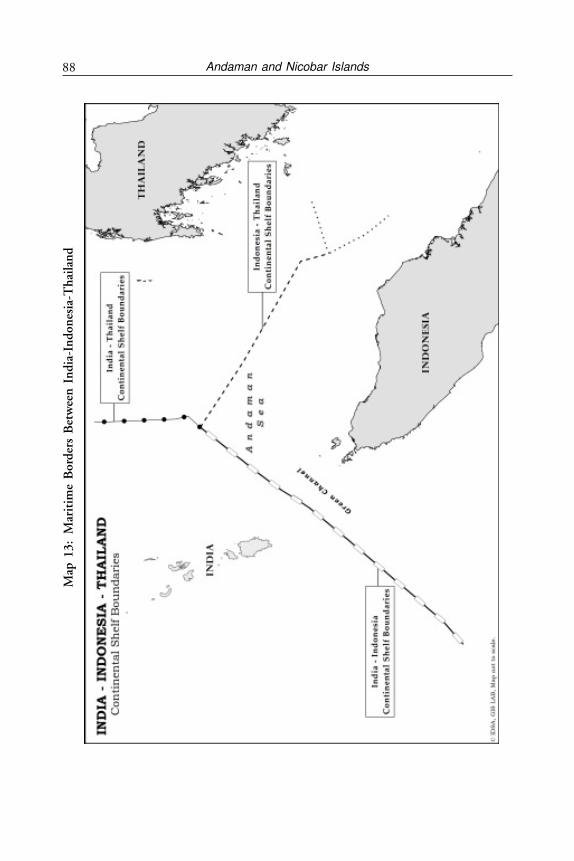
Andaman and Nicobar Islands88M
ap 1
3:
Mar
itim
e B
ord
ers
Bet
wee
n I
nd
ia-I
nd
on
esia
-Th
aila
nd
89The International Law of the Sea and India’s Maritime Legislative History
Indonesia concerning the determination of the tri-junction point and thedelimitation of the related boundaries of the three countries in the AndamanSea was signed on June 22, 1978.
With Maldives and Sri Lanka
An agreement between Sri Lanka, India and Maldives concerning thedetermination of the tri-junction point between the three countries in the Gulfof Mannar was signed on July 23, 24, 31, 1976.
With Myanmar and Thailand
An agreement between the Government of the Union of Myanmar, theGovernment of the Republic of India and the Government of the Kingdom ofThailand on the determination of the tri-junction point between the threecountries in the Andaman Sea was signed on October 27, 1993.
NOTES
1. Swaminathan S. Anklesaria Aiyar, Swaminomics, Times of India, March 17, 2013.
Andaman and Nicobar Islands90
CHAPTER 5
South China Sea
“ASEAN’S PALESTINE1”
Surin Pituswan, former Secretary General, ASEAN
China, ASEAN and India
CHINESE POLICY OF DECLARING CORE INTEREST AND THE
CAMOUFLAGE OF PEACEFUL RISE
China’s policy of declaring core interests which are non-negotiable is apsychological tactical move. From Taiwan as a core interest to Tibet and Xingjiangand now South China Sea, it is an increasing list over which China has vaguehistorical claims but is prepared to use its military for securing them. Its firststep towards use of military force over Tibet started in the 1950s immediatelyafter the communist party took over defeating Chiang Kai-shek. Taiwan wasrecognised by Western powers and now is part of China’s core interest. The Tibetoccupation process took nearly 10 years culminating in the Dalai Lama leavingLhasa in the middle of night and seeking refuge in India. However, it became acore interest later. China has now built up a formidable navy and is making un-substantive claims over East and South China Seas, annoying Japan, South Korea,Philippines, Brunei, Taiwan, Vietnam and Malaysia. The doctrine of declaringcore interest and ‘bullying’ smaller states is part of China’s foreign policy plankof ‘Peaceful Rise’.
BASIS OF CHINESE CLAIMS OVER SOUTH CHINA SEA
South China Sea consists of around 250 islands, atolls, cays, shoals and sandbarsmost of which are uninhabited and some permanently submerged. These arelisted as archipelagos. Macclesfield Bank, Scarborough Shoal and Spratly Islandsare disputed between Peoples Republic of China and Vietnam with Malaysia,Philippines and Brunei also claiming a part of the archipelago. The Paracel Islandsare disputed between Peoples Republic of China (PRC), Republic of China(Taiwan) and Vietnam. The Pratas Islands are disputed between PRC and the
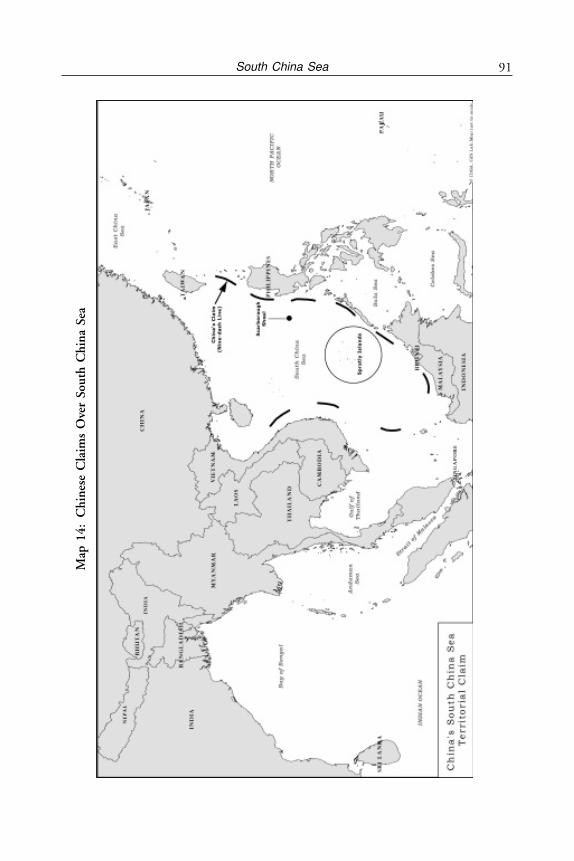
91South China Sea
Map
14
:C
hin
ese
Cla
ims
Ove
r So
uth
Ch
ina
Sea
Andaman and Nicobar Islands92
Republic of China. The Macclesfield Bank is disputed between PRC, Republicof China (Taiwan) and Philippines. The Scarborough Shoal is disputed betweenPRC, Republic of China and Philippines. There are minerals, natural gas andoil deposits in dispute. Estimates and undiscovered oil reserves in South ChinaSea as mentioned earlier, range as high as 213 billion barrels of oil.2 Vietnam isalready a major producer of oil with production of 24.4 million tons. 26 percent of its total produce comes from the South China Sea. Petro-Vietnam, apublic sector undertaking has already concluded about 60 oil and gas explorationcontracts with various foreign countries. However, China is using force to stopthis. In May 2011 two maritime surveillance vehicles cut off the explorationcables of a Vietnamese exploration ship.3 ASEAN wants to present a unitedapproach for a code of conduct in this region. Philippines wants a dispute redressalmechanism but China wants to settle only bilaterally.
China bases its claim on a large part of the South China Sea on 2000 yearsof history, which it claims gives Beijing a compelling argument for controllingthis vast area of sea. Chinese officials argue that the Paracel and Spratly Islandchains were once important parts of the Chinese nation and could have richreserves of fossil fuels. Such arguments of Chinese history are vague, not acceptableto others and legally very difficult to prove. As Santosh Kumar, formerly of theIndian Foreign Service (IFS), points out “Beijing’s claim on grounds similar tothose for Tibet, and adjoining Indian territory, are based on 2000 years of historyduring which it says that the islands were regarded as an integral part of China.”4
Moreover, Vietnam and the Philippines strongly refute China’s claim. China doesnot want arbitration or even a multilateral approach to solve it. It wants to doit bilaterally so that it can indulge in arm-twisting of weaker nations. It nowconsiders its claims in South China Sea as it’s ‘core interests’ adding to its list ofTibet5 and Taiwan.
China’s claim over the entire South China Sea (and also East China Seawhere it has disputes over islands with Japan) and military action to secure it isreminiscent of the manner in which it took over Tibet in 1950-59. Whilealternative routes from the Middle East and Africa for energy supply are beingworked upon as discussed in chapter 3, the Indian Ocean route is largelyunavoidable. China is getting gas and oil from the Central Asian countries andRussia, but there are road blocks. The South China Sea and the East China Seaclaims aim to look for various potential hydrocarbon resources. China’s sustaineddevelopment is dependent on energy.
China’s cartographic aggression is well established. Based on historical claimsit has tied India into knots over Arunachal Pradesh in North East India andLadakh in the North West. In a similar manner it is now claiming the entire Eastand South China Sea based on China’s mysterious “Nine Dash Lines”.6
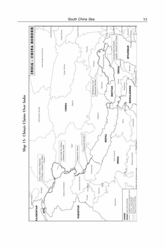
93South China Sea
Map
15:
Ch
ina’
s C
laim
s O
ver
Ind
ia

Andaman and Nicobar Islands94
Communist China is essentially a military power from its earliest days startingwith 1949. The political approach to sustain China’s energy supply is being seenby the PLA as a weakness. The PLA is emphasising military solutions. At thesame time it may be said that China has land borders with 14 countries and hassuccessfully used diplomacy and its power to settle 12 of them including Vietnam.Its unresolved border with India and its taking away parts of Kashmir fromPakistan which were under Pakistani occupation is a matter of tension with India.The PLA Navy is in the process of establishing its fourth fleet in San Ya, HainanIslands. Equipped with at least one aircraft carrier, modern frigates and destroyers,and advanced submarines including SSNs and SSBNs, this fleet will dominateover other countries in the South China Sea.
Oil Rush in South China Sea: According to estimates by the Chinese, theoil deposits in South China Sea could be as high as 213 billion barrels, which aremore than Kuwait’s reserves. This figure may be disputed by the US EnergyInformation Administration (EIA) which puts it around only 28 billion barrelsbut it is still a great deposit. Further, it is estimated that natural gas accumulationin the region may be 25 trillion cu m, which is equal to the proven reserves ofQatar.7 Be that as it may, China sees great potential in getting hold of this areaand has therefore made a claim over the entire South China Sea. This has beendone by making a claim of sovereignty over the Paracel and Spratly Islands. Howvalid is this claim? Paracel Islands were with Vietnam till 1974 when Chinaforcibly wrested control from Vietnam over this island. However, the Chineseclaim goes back 2000 years as in the case of Tibet. These islands were regardedas a part of Imperial China when China was comparatively weaker. Chineseclaim over these islands is as weak as it was over Tibet.
CHINA’S STATUS UNDER UNCLOS III AND DISPUTES WITH ITS
MARITIME NEIGHBOURS
While UNCLOS III does not go into sovereignty issues, once a state becomes aparty to UNCLOS III, it is obliged to bring maritime claims and national lawsinto harmony and conformity with the convention. It is also a principle ofInternational Law that one cannot use its domestic laws as an excuse not toconform to its obligations under International Law. China has however, exercisedits right under Article 298 to get out of the compulsory binding dispute settlementregime. It wants to settle disputes with each country bilaterally and dissuadedASEAN not to even discuss it or even pass a code of conduct for South ChinaSea.
Under these conditions, the Chinese belligerent attitude is also part of itsinsecurities. The two main insecurities of China in this context are its inabilityto have stable control over Tibet and securing the SLOC, particularly in theStraits of Malacca. If it gets control and sovereign rights over South China Sea

95South China Sea
and is able to pump out oil, the issue of oil supply through Straits of Malaccawill become less important.
In the case of India, the Chinese have not only encircled but also taken over5000 square km of the territory of Kashmir which was under Pakistan’s occupation.In 1963, China signed a border agreement with Pakistan under which theyaccepted that the area is under dispute with India and interestingly, they didmention that this territory is subject to final settlement between India and Pakistan.Now they are investing and working even in the area which is with Pakistan asa disputed territory. India’s protests are weak and hardly known in India. Theyare also building a pipeline from Gwadar Port through this territory into Chinaand have recently signed an agreement with Pakistan of building a pipeline/tunnelthrough it. Similarly, in South China Sea which has potentially major petroleumdeposits, China has laid claim to the entire area, which is not acceptedinternationally and by half the ASEAN countries like Philippines, Indonesia,Malaysia, Brunei, Vietnam and Taiwan. This has been followed by physicaloccupation of some islands and use of navies/coast guard to drive away othernationalities from fishing. In the East China Sea, they have also laid claim overJapanese owned Senkaku Islands.
Although it is already facing problems due to maritime territorial disputeswith Japan, Vietnam, Philippines, Brunei and Indonesia in South and East ChinaSeas, China has encircled India in a strategic alliance with Pakistan, Myanmar,Sri Lanka and Bangladesh. India is now at the stage of facing the Chinese onslaughtas part of their maritime aspirations extending into the Indian Ocean. Chinaalso plans to build a fleet of aircraft carriers as part of their naval modernisation.They are now attempting to increase their presence in the Indian Ocean. Thefirst step has been taken by them by setting up a base in Seychelles.8
The Chinese Government has got approval from the International Sea BedAuthority (ISA) to explore and mine deposits of poly-metallic sulphide ore, asource of zinc, lead, iron, silver and gold in 10,000 sq km of the seabed in theSouth-West Indian Ocean. While they have stated that such seabed explorationwould serve the common interest of mankind, it should be taken with a pinchof salt. It is not clear why China has been given licence to explore the seabed inIndian Ocean and not in the Pacific. Whether India objected to it or not is alsonot known. Having claimed the entire South China Sea, China’s designs onIndian Ocean need to be watched carefully.
It is necessary for India now to provide a credible projection of its presence,both hard and soft, not only along its maritime borders on the mainland but alsoin the Bay of Bengal where Andaman & Nicobar Islands are located. Will Chinaclaim parts of Indian Ocean as their core interest in their next stage of dominance?
China is the world’s largest energy consumer. It receives over 70 per cent ofits petroleum imports via the Indian Ocean. An official of the Development
Andaman and Nicobar Islands96
Research Centre (DRC) under their State Council, the Chinese equivalent of aCabinet, has stated that Government of India should take the initiative to proposea cooperative mechanism on sea lanes in the Indian Ocean. This itself is a majornew development where China has pointed out that there is a vacuum in theIndian Ocean which needs to be filled. This refers in particular to the Strait ofMalacca. India, therefore, needs to take an urgent initiative of making theseislands its real frontier in the context of maritime activities like it did for North-East India in the fifties by forming NEFA (after taking it out of Assam andputting in under (MEA) through the Governor of Assam acting as Agent of ThePresident of India. This proposal has been elaborated in chapters 9 & 10.
China-India-Vietnam and South China Sea: Chinese Strategy ofDenial
The Chinese Defence White Paper of January 2008 points out the struggle forcornering strategic resources, dominating vital areas and strategic locations. TheChinese point out that they are implementing the military strategy of “activedefence” which implies development of Advanced Assault Capabilities. They havedeveloped this into the doctrine of “Access Denial”. This involves developingcapabilities of modernisation of weaponry of all types: cyber war fare, anti-ships,anti-carriers, SSBN capability etc. This also implies protecting and securingmaritime interest which is implemented both in terms of direct military actionin South China Sea and the String of Pearls Strategy.9 With declared core interestsincreasing, starting with Taiwan then Tibet, Xinjiang and now South China Sea,the Chinese intolerance of other countries sovereign claims is increasing and isbeing reflected in military terms.
India’s cooperative oil exploration in South China Sea with Vietnam is acritical test of Chinese doublespeak, its overbearing tactics and its ability to arrogateto itself certain positions only on the strength of its ability to speak strongly,which, to its credit it has been doing even when it was a poor and weak nation.While China wants India to be a non-player beyond South East Asia, it does notstop itself from meddling in India’s neighbourhood of Pakistan, Myanmar,Bangladesh, and Sri Lanka. There is absolutely no justification for China to objectto India’s participating in joint exploration with Vietnam in the oil and gas richSouth China Sea. It may be pointed out that India’s trade with East Asia exceedsthat with EU or US.10
The Chinese have opted to use strong arm tactics by small acts like stoppingBP and Exxon Mobil from drilling off Vietnam in 2007-08, challenging a USNavy ship 75 miles from Hainan Island in 2009 or challenging Indian navalvessels and India’s ONGC vessels around Vietnam. They are objecting to Indiaundertaking cooperative oil exploration with Vietnam. China’s claim in SouthChina Sea is not acceptable to other littoral countries as it is not based on law.However, it is felt that if China is not able to secure sovereignty of these areas by
97South China Sea
making vague historical claims it would settle for joint exploration of oil withthese countries bilaterally.
Chinese Insistence on Bilateralism Instead of Arbitration underUNCLOS
Chinese claims in the South China Sea have been analysed by Leszek Buszynski11
of the Australian National University (ANU). According to him, China andVietnam claim the entire South China Sea, while Malaysia, Philippines, Indonesiaand Brunei have laid claim to contiguous areas. The two principles that governclaim, work against Chinese claims to the entire area. One is effective occupationand the other is the second principle of UNCLOS which lays down the rules toclaim resources based on the EEZ and the continental shelf. The effectiveoccupation principle has made China occupy by force Paracel Islands—anarchipelago of 30 islands nearly equi-distant from Chinese and Vietnamese coastsand the Spratly Islands—an archipelago off the Philippines and Malaysian coasts.The Chinese claim is based on history but does not carry much weight. Vietnam’sparliament has already passed a maritime law that reasserts claims to Spratly andParacel Islands. Simultaneously China National Offshore Oil Corporation(CNOOC), a Chinese state owned company has opened nine blocks tointernational bids for oil and gas exploration which reach within 37 nm ofVietnam’s coasts. According to the Economist Magazine this was probably apolitical stunt by China in response to Vietnam’s new law.12 UNCLOS cameinto being in 1982 and the Chinese do not want to use UNCLOS which has anarbitration clause. While China has opted out of arbitration under Article 298,the Philippines have gone to UNCLOS in spite of it. The Philippines case maynot be hopeless on the grounds that Chinese claim over South China Sea is notreally a sea boundary delimitation. If Philippines gets over the jurisdictional issue,it has a good chance of winning.13 Although, technically speaking, UNCLOShas no provision about how to deal with sovereignty, however, the provision ofUNCLOS on baseline, the regime of islands, low tide elevations, the EEZ, thecontinental shelf; maritime boundary delimitation and dispute settlement areall applicable to South China Sea. The ASEAN countries since 2009 have takenmeasures to clarify their claims and bring them to conformity with UNCLOS.Even though China has opted out of the system of compulsory dispute settlementfor disputes relating to maritime boundary delimitation and historic waters, somelegal disputes pertaining to interpretation or application of provisions ofUNLCOS are subject to Compulsory Binding Dispute Settlement under part XVof UNLCOS. In addition, it may be possible for ASEAN countries to seekadvisory opinion from International Tribunal for the Law of the Sea (ITLOS)on one or more legal issues relating to the South China Sea Dispute.
In a commemorative summit to mark the 20th Anniversary of India’s LookEast Policy held in Delhi with ASEAN in 2012, ASEAN sought intensification
Andaman and Nicobar Islands98
of Maritime Security Cooperation with India, calling for freedom of navigationand safety of sea lanes for unfettered trade in accordance with International Law.14
Vietnam also offered the port of Nha Trang on South China Sea for the use ofthe Indian Navy. A Vietnamese delegation led by its Naval Chief, Vice AdmiralNgyuyen Van Hien visited India in 2011 for this purpose.15
According to Lowy Institute for International Policy of Sydney, all states ofSouth China Sea including China are legally bound by provision of UNCLOSIII. It has been established that the legal framework of settling rights andobligations with respect to use of portions under UNCLOS also sets out maritimezones that the coastal states can claim including 12 nm of territorial sea, and anEEZ of 200 nm. However, in South China Sea there is a major dispute withPhilippines, Vietnam, Brunei, Taiwan on one end and China on the other leadingto use of force by China. China’s claims to most of South China Sea cannot bereconciled with claims of other states as its claims are based on history.
Michael Wesley, former Executive Director, Lowy Institute for InternationalPolicy says the disputes could have global implications. “The first level is a setof territorial disputes between China and several Southeast Asian countries.” Hefurther stated that “The second level is a dispute between China and the US overthe conditions under which ships pass through this waterway, which convey abouta third of all global shipping. And, I feel that there is a real chance that conflictcould break out because of inexperienced maritime forces, with little or no mutualunderstanding of how to manage maritime incidents.” Wesley is calling onAustralia, which has strong military ties to the US and an entrenched economicrelationship with China, to do more to broker a deal in the South China Sea.“Look, Australia really needs to be more concerned about this issue,” he said.“About 54 per cent of Australia’s trade passes through the South China Sea, andreally what is at stake for Australia here is the outcome of the standoff betweenChina and the US could have a real effect on the strategic balance of the PacificOcean. So we have really big interests in this.” According to Wesley maritimetensions pit communist China and Vietnam against one another, unite usualenemies China and Taiwan, and draw the US back into partnership with Vietnam.
China-US Rivalry in the Straits of Malacca and South China Sea
Middle East is the biggest supplier of oil to China, Japan and Korea. China hasestablished a strategic oil reserve and by 2020 it should have a reserve capacityof 90 day’s crude oil imports. The first phase of its reserve has been completedin 2009 with about 100 million barrels or over 20 days of oil imports. The reserveis about three times that of India. While China is incapable of stabilising theMiddle East tensions, it wants to keep South East Asia including the South ChinaSea lane under its influence. The US presence in South China Sea and in theStraits of Malacca is not to their liking. However, with their aggressive maritimeclaims in the South China Sea they have lost a lot of goodwill and will have to
99South China Sea
depend upon their military strength alone. China had already deployed in 1988PLAN troops for a garrison to guard the disputed islands claimed by them andVietnam in South China Sea in order to reinforce their claim. In the conflict,Vietnam lost three vessels that were set on fire and three men died, some werewounded and 70 were missing.16 The Chinese have also elected 45 legislators togovern 1,100 people who live in the Islands of Spratly and the Paracel to provetheir jurisdiction. Similarly, China and Philippines are also fighting overScarborough Shoal near the coast of Philippines but claimed by China. The recentdebate in the ASEAN meeting in Cambodia in 2011 where ASEAN as a groupwas not able to pass a resolution on a Code of Conduct because of arm twistingof Cambodia by China is a reflection of the present state of affairs. In fact, thiswas the first time that such an ASEAN meeting was not able to issue a jointcommunique.17 This also shows the extent of different views over China in the10 country group of ASEAN and how China is able to exploit it. The differenceshave since then been resolved in 2013 after Brunei took over the chairmanshipof ASEAN.
The US also has interests in Malacca and South China Sea. The first is todeter a threat of attack and therefore control the Straits of Malacca and secondis to use the South China Sea route undeterred. The Chinese feel that this amountsto “certain power share”. As a result they have started both defensive and offensivenaval strategies. The US, on the other hand, wants to prevent the rise of ahegemonic state and therefore, wants to build up allies and partners. It has alliesin Japan and South Korea. There is no doubt that as of present the US is thebiggest stakeholder in the Straits of Malacca followed by China. The South ChinaSea has now become an issue of US-China strategic rivalry. As China deploysnew naval capabilities and strategies, it is no more a complimentary relationship.China would like to settle for a favourable regional arrangement in which territorialclaims would be adjusted and oil reserves would be shared. The ASEAN is notagreeable and the US has openly sided with the ASEAN at the Hanoi RegionalForum meeting. In July 2010, the US Secretary of State, Hillary Clinton backedthe ASEAN countries’ claim and stated clearly that claims in South China Seashould be pursued on the basis of UNCLOS and land features.18 US has alsolifted the ban on ties with Indonesian Special Forces in July 2010 and thePhilippines continues to be a major non-NATO ally of US.
While the US Navy may be on the decline, it is certainly increasing its presencein the South China Sea.19 US has proposed to station ships in Singapore andPhilippines. Both countries are likely to accept the request. The purpose of themove is to keep the sea lanes open. In addition, the US military is also increasingits presence in Australia. Japan, in any case remains a close ally.
China-Japan rivalry over Senkaku Islands (called Diaoyu by the Chinese) inNorth China Seas is leading to yet another major tension. While US is an allyof Japan, so far it is keeping a neutral position. With the purchase of Senkaku
Andaman and Nicobar Islands100
Islands by the Japanese Government the long simmering rivalry between Chinaand Japan is now a major issue. According to Greg Nancy,20 US must take adecisive step and insist on international mediation. Since both nations use historyselectively and international law to justify their claims, it is leading to protest inChina where Chinese have vandalised and looted Japanese companies likePanasonic and Toyota which suspended operations in China.
ASEAN–China: Code of Conduct in South China Sea
ASEAN consists of 10 countries of which at least five have definite maritimeproblems with China i.e. Vietnam, Philippines, Indonesia, Malaysia and Brunei.The other members of ASEAN namely, Cambodia, Myanmar, Singapore haveno problem with China. Myanmar and Cambodia have huge Chinese interestsand investment in their country but it can be noticed that Myanmar is trying tocool off its relations with China. Singapore would welcome an alternative powerlike India to counterbalance China while Cambodia’s present dependence onChina with no territorial dispute would continue to back China. Japan, not amember of ASEAN but being in the same predicament as Vietnam, Philippines,Brunei and Indonesia would be happy to back the anti-China group withinASEAN. Taiwan has similar problems as the countries mentioned above.
The issue of evolving a Code of Conduct in South China Sea has been amatter of tension between the two. While ASEAN countries especially thoseimpacted by China’s claims are keen for a formal Code of Conduct betweenvarious countries so that they do not come into conflict, China has been evadingthe subject and would like to settle maritime border claims bilaterally only. Therewas little progress in the last Summit held under the chairmanship of Cambodia.However, foreign ministers of ASEAN and China have now agreed to hold aspecial meeting to speed up the progress on a Code of Conduct in South ChinaSea.21 This proposal has come from China although no date has been fixed. Inthe meantime, China is opening up some disputed islands to tourism.22 Whilein July, 2012, the ASEAN Forum ended without a joint communique, in July,2013 they issued a communique emphasising the 11-year-old non-bindingagreement between China and ASEAN to peacefully handle competing claims inSouth China Sea.23
Vietnam, India and South China Sea
The only country which has given Communist China a hard time is Vietnam.The Chinese forces were able to beat back the US forces in 1950. In 1962, itwanted to teach India a lesson which indeed it did. In 1969 it gave USSR ahard time on the Ussuri River. However, when it came to Vietnam, it bloodiedChina every time it came down South. In 1979 it gave PLA of China a drubbingkilling 25,000 and injuring 75,000 of its 100,000 troops which came down to
101South China Sea
teach Vietnam a lesson. Vietnam is now seeking India’s hand in a partnershipwith cooperation in joint oil exploration. The Indo-Vietnam agreement overexploration of blocks 127 and 128 off Spratly Islands between ONGC Videshof India and the Vietnamese authority has provoked China to issue aggressivestatements. China issued a demarche to India that its permission was necessarybefore India could explore in these waters. This is similar to what the Chinesedid in the 1950’s after they militarily occupied Tibet. By 1954, India gave up itspresence in Tibet voluntarily and reached a quid pro quo settlement and calledit a region of China by signing the 1954 Panchsheel Agreement.24 Global Times,a party paper of CCP had stated that the Indo-Vietnam deal was a seriousprovocation to the Chinese Government and urged the Chinese Government tostop this cooperative effort from happening. China’s People’s Daily was a littlesofter and asked the three countries to come out with specific locations of theconcession so that jurisdiction over it could be verified.25 Although, India hasso far not found any oil in block 127 or 128 in spite of having spent over US$30 million in exploration, Vietnam does not want India to leave the block.Politically also, India should not leave.
A month after China objected to oil exploration by India in the South ChinaSea under a contract awarded to the Indian state-owned company ONGC VideshLtd. by the Vietnamese and three months after the Chinese Navy warned theIndian naval ship Airawat, which was sailing in international waters between theVietnamese ports of Nha Trang and Hai Phong, to leave Chinese waters—awarning that INS Airawat ignored—India and Vietnam signed an agreement onenergy cooperation. The agreement was signed during the visit of VietnamesePresident Truong Tan Sang to New Delhi to further cement the India-Vietnamesestrategic partnership. The two countries also decided to pursue a regular securitydialogue, which has further incensed the Chinese.26
India has, however, rejected the Chinese objection on grounds that theVietnamese claims are in accordance with international law. The then ForeignMinister S.M. Krishna had stated that ONGC Videsh will go ahead with the oiland gas exploration.27 According to Lexzek Buszvnsky, this changes andcomplicates the situation as India has status and power to resist China.28 Indiaand Vietnam signed an agreement on energy cooperation during the visit ofVietnamese President Truong Tan Sang to New Delhi. The two countries alsodecided to pursue a regular security dialogue.29 Further, at the 14th India-VietnamJoint Commission meeting on Trade, Economic, Scientific and TechnologicalCooperation co-chaired by Indian Foreign Minister, Krishna his counterpart PhamBinh Minh, and Krishna stated that with the growth of strategic partnership tothe satisfaction of both sides there is a need to add greater content to bilateralrelations by adding defence and security among other items.30
The Chinese worry is that India is gradually expanding its presence in EastAsia where Beijing has been holding influence over small countries. These
Andaman and Nicobar Islands102
countries, mostly members of ASEAN are in favour of India playing a role in abig way as a balance. According to Bharat Karnad, Professor at Centre for PolicyResearch (CPR), New Delhi “Vietnam has offered port of Nha Trang in SouthChina Sea for Indian Navy’s use and Indian navy flotilla voyaging frequentlybetween Andaman and Nha Trang, sustained by a parking and provisioningarrangement on the Central Vietnamese Coasts, will amount to a near permanentIndian presence in the South China Sea, signalling Indian intent and forwardpositioning that can mess up the Chinese naval and strategic calculations andpush Beijing planners for once on a back foot. At a minimum, it will be ananalogue to the sizable Chinese para-military (Peoples Armed Police) presence inGilgit and Baltistan regions of POK.”31
It has also been reported that India has accepted the offer of Vietnam toallow Indian naval warships to drop anchor at its southern port of Nha Trang.It will give India the key to sustainable presence in South China Sea and willenable India a bigger role in the strategic South-East Asian region which overlooksthe key shipping lines. It will also make Andaman & Nicobar Islands more relevantas naval ships will be more frequent between Vietnam and Andaman & NicobarIslands.
According to Economist,32 Vietnam could be India’s Pakistan, a loyal ally asPakistan is to China that exerts indirect debilitating pressure on its strategic rival.Further, it states “India also wants to push back what it sees as a Chineseprovocation. Among these is the apparent Chinese stroking of unresolved territorialdisputes that led to the 1962 war. In recent years, it has revived its claims to mostof Arunachal Pradesh”.
However, late B. Raman, a strategic analyst of India and a former AdditionalSecretary in the Cabinet Secretariat, in his article ‘South China Sea’33 had statedthat ‘India should avoid rushing in where even US exercises caution’. WhileChinese claims in South China Sea had been rejected by the US and the Indianposition has been similar to that if the US, it had led into ‘inherent seeds of anundesirable military confrontation between India and China in the South ChinaSea’. He had further stated that it would take India five to 10 years to bring itsinfrastructure on par with China in Tibet where India can expect retaliation.While this may be true, in case there is a confrontation with China in SouthChina Sea, India expects support from the ASEAN, the US, South Korea andJapan.
Raman’s argument need not be accepted. The difference of 5 to 10 years ininfrastructure between India and China pointed out by him is something whichIndia cannot easily make up in a short time especially when the terrain is not inits favour. However, instead India needs to develop an Access Denial Strategy inthe Bay of Bengal with the aim to deny maritime access to China’s military orany other inimical extra regional power in areas which are of core interest to
103South China Sea
India. Besides the McMahon line, the Ladakh border, India should also declareparts of Bay of Bengal as its core interest. India’s EEZ, while open to ships fornavigation, should be under surveillance, especially in Bay of Bengal, to ensurethat Chinese naval ships do not roam around freely without a quid pro quo.Therefore, there is a need to not only build up a naval and air presence in theAndaman & Nicobar Islands but go beyond and build up a naval presence inVietnam in collaboration with their government. In fact, it is necessary for Indiato strengthen its presence in Great Nicobar Islands and develop a network ordefence pacts with ASEAN countries to ensure that if Chinese do anythingfoolhardy34 either on India’s northern borders or with ASEAN countries, Indiawould in a position to take retaliatory measures in South China Sea/Straits ofMalacca. Therefore, Indian efforts at consolidating friends/allies/partners in theIndian Ocean have been in the right direction which is described in chapters 6and 7.
The regional political bloc ASEAN is continuing to explore new ideas toresolve the dispute. With Brunei taking over the rotational annual chairmanshipof ASEAN in 2013 and a new Secretary General, Le Luong Minh, a formerVietnamese diplomat, there may be some new developments in resolution of theissues. Brunei is oil rich and is not dependent on China’s largesse like Cambodia,the previous chair of ASEAN was. Vietnam is already suspicious of Chineseintentions in the South China Sea and therefore, the new Secretary General willbe tougher on China. At the same time US has deepened its strategic ties withPhilippines, Singapore, Indonesia and Vietnam.35
What Should Be India’s Strategy Towards China in the MaritimeSphere Including South China Sea?
While the Indian Navy is going strong on having a forward policy instrengthening Andaman & Nicobar Islands by opening a new airbase called Baazat Great Nicobar Island, the MEA, on the other hand, is soft peddling the issuethereby making India look weak. The statement on the other hand by Chief ofNaval Staff Admiral D.K. Joshi that the Indian Navy is ready to protect its interestin South China Sea even if it means sending forces to it is strong and reassuring.36
He also stated that rapid modernisation of the Chinese Navy is a concern toIndia. His statement found resonance among Asian states and was welcomed bythe Vice-President of Philippines. However, the Indian National Security Advisor(NSA) Shivshankar Menon who was at the time in Beijing was unhappy aboutit. India needs to be more circumspect and pro-active in South China Sea thanthey were in the Himalayas. During the visit of the Chinese Defence Minister,General Liang Guanglie to India in late 2012, the first such visit since 1976, ina joint communique, the two countries agreed to cooperate in the Asia-PacificRegion. While most of this went unreported and there was silence on both sides,it did raise the question that the Chinese finally noticed India’s geopolitical

Andaman and Nicobar Islands104
importance in Asia-Pacific which they never bothered to do earlier. In fact,between the Dalai Lama and Straits of Malacca, India has two bargaining pointswith China. Here, Andaman & Nicobar Islands can play a major role if they aredeveloped as a major naval and air base.
The Chinese are concerned over Indian naval capabilities in the Indian Oceanand their potential alliance with US in blockading China’s oil supplies. Theyhave noted with interest the establishment of Andaman Nicobar Joint Commandand the naval fleets of US, Japan and India working together. According to C. RajaMohan, “The mutual distrust between India and China on multilateral issuesdeepened in 2000s despite the proclaimed desire for cooperation on global andregional issues and hopes for coordination of issues relating to energy and maritimeissues”. In this connection, he quotes Robert Blackwell who was President GeorgeBush’s First Envoy to India during 2001-03: “President George W. Bush basedhis transformation of US-India relationship on the Core Strategic Principle ofDemocratic India as a key factor in balancing the rise of China”. He furtherquotes an editorial in China’s Global Times of June, 2009 which acknowledgedIndia’s growing power potential but dismissed New Delhi’s ability to leverage itwith China by avoiding a closer strategic partnership with the US and goes onto say that if India thinks that fear and gratitude for its restrain will cause Chinato defer on its territorial disputes then it is mistaken as China will not make anycompromise on its border dispute with India.37 At the same time, BrahmaChellaney feels that “while Hillary Clinton has declared that US-Japan Treatyapplies to Senkaku Islands, it does not mean that US would use its militarycapability to repulse Chinese action.” Taking on from here, he feels that whileUS wants to build up new strategic partnerships with India, Vietnam, Indonesiaetc., it is wary of taking sides in Asian territorial disputes and should not bedepended upon.38
According to Aaron Friedberg,39 a scholar at Princeton University on Chineseissues, China is building an “Anti-Access Capacity”. It is building a defence weaponsystem that will deny access to areas it believes are in its historical sphere whichincludes Tibet/Taiwan/Arunachal Pradesh and South China Sea.
The Chinese Naval Maritime Plan of 1982 outlined by then Vice Chairmanof the Military Commission, Liu Hauquing laid down a three stage plan. Thefirst stage which ended in 2010 was to establish control of waters within the firstisland chain which extends from Japan to Okinawa and covers both the East andSouth China Sea up to Straits of Malacca. The second stage which was to startfrom 2010 and end in 2020 would be China establishing control of waters withinthe second island chain linking Ogasawara Island, Guam and Indonesia. Duringthe last and final stage from 2020-40 China would aim to put an end to USMilitary dominance in the Pacific and Indian Oceans using aircraft carriers. TheChinese have been quietly committed to this policy and have been increasing
105South China Sea
their naval capability in a very fast manner. The PLA Navy is now focussing on“Sea-Denial” or “Anti-Access” capabilities.40
The latest tactical step by the Indian Navy has been the announcement in2012 of establishment of a forward base in Great Nicobar Island called Baaz—a step in the right direction. This conforms to the concept of Access Denialwhich should apply to a country like India. Such a strategy will seek to contestand deny regional or extra regional countries their ability to project military powerunilaterally to secure their interest either through aggression or through de-stabilising activities.
Therefore, a Maritime Access Denial policy needs to be developed. Accordingto Admiral Vijay Shankar (Retd.) former Commander in Chief, Strategic ForcesCommand (SFC) of India, there should be a trigger to implement such a policywhich he calls “Red Lines”. He has defined it in the following manner:
(1) Any large scale attempt to change the status quo in India’s territorialconfiguration.
(2) Large scale military build up at Hambantota in Sri Lanka or Gwadar inPakistan or Sittwe in Myanmar.
(3) Aggressive deployment that disrupts India’s own energy supply andresource traffic or dislocates the network.
(4) Any attempt to provide large scale military support, covert or otherwise,to promote internal warfare against states.While Admiral Vijay Shankar’s “Red Line” may not be easilyimplementable, what India requires is a definite presence in South ChinaSea to counter any further move by China in POK, Gilgit or Baltistan.As a result, it is important for India to look towards ASEAN and otherlittoral countries of Bay of Bengal as well as South and East China Seasand build up a civil and military relationship.
Chapter 6 describes the development of relationships of India in the civil sphereand Chapter 7 in military terms. The role of Andaman & Nicobar Islands inthe new Look East Policy by countering China in north and north-west Indiashould be the focus of this policy to meet China from a position of strength.Chapters 9 and 10 will focus on this.
NOTES
1. The Telegraph, December, 2012.2. Based on US Energy Information Administration Report of 2008.3. Leszek Buzneski, “The South China Seas: Oil, Maritime Claims, and US-China Strategic
Rivalry“, The Washington Quarterly, 2012.4. Santosh Kumar, “South China Seas Oil Rush”, Economic Times, November 25, 2011.5. Chinese claims over Tibet and its armed accession in 1950s is also based on their version
of history.6. “South China Seas: Hang it both ways”, Economist July 08, 2012,
Andaman and Nicobar Islands106
7. Santosh Kumar, no. 4.8. “China to Open its First Military Base Abroad in Indian Ocean” The Economic Times,
December 12, 2011.9. Vice Admiral Vinay Shankar (Retd), “Securing Sea Power and the Right to Un-impeded
Entrée: The Uncertainty Paradigm”, Defence and Security Alert, 2012.10. Binod Singh, “About Supremacy, not sea”, Times of India, September 25, 2011.11. Leszek Buzneski, no. 3.12. www.economist.com/node/215582626?frsc=dg%7ca13. Julian Ku, “Game Changer? Philippines seeks UCLOS arbitration with China over South
China Sea”, Opinion at www.juris.org/2013/01/22/game-changer/phillipines-seeks-UNCLOS-arbitration-with-China-over-the-south-china-sea/
14. “India–ASEAN Seek Enhanced Maritime Security Cooperation”, Mint, December 21, 2012.15. Bharat Karnad, “Good Morning, ‘Nam”, Asian Age, July 7, 201116. B.R. D.E. Lengochy, “Chinese invasion of Spratly Islands in 1988”, at www.eyedrd.org/
2011/07/chinese/invasion-of-spratly-islands-in-1988.htm.17. Sana Hashmi, “South China Sea in Imbroglio: An Indian Perspective”, Journal of Air Power
& Space Studies, 8 (1), 2013, p. 156.18. Leszek Buzneski, no. 3.19. Reuters December 16, 2012 at www.reuters.com/article12011/12/16us-navy-asia-IDUSTRE720. Rodger Baker, “Understanding China-Japan conflict”, at www.stratfor.com/weekly/
understanding-china-japan-island-conflict#21. Yahoo news Singapore, at www.sg.news.yahoo.com/ASEAN-China-meet-maritime-code-
conduct-1622. Yahoo news Singapore, at www.sg.news.yahoo.com/china-open-disputed-islands-tourism-
074350423. Simone Orendain, “China agrees to discuss ‘Code of Conduct Rules’”, Globalsecurity.org:
July 4, 2013.24. For details see Claude Arpi, Born in Sin: The Panchsheel Agreement: The Sacrifice of Tibet,
Mittal Publications, New Delhi, 2004.25. Santosh Kumar, no. 4.26. “Countering China’s Encirclement Plan”, Deccan Herald, October 31, 2011..27. Times of India, September 17, 2011.28. Leszek Buzneski, no.3.29. Gurmeet Kanwal, “Strategic Encirclement by China, Looking East to counter it”, The
Tribune, November 12, 2011.30. Times of India, September 17, 2011.31. Bharat Karnad, no. 15.32. Banyan, “Not as close as lips and teeth: China should not fear India’s growing friendship
with Vietnam”, Economist, October 27, 2011, p. 42.33. B. Raman, “South China Sea: India should avoid rushing in where even US exercises
caution—analysis,” September 18, 2011, Eurasia Review at www.eurasiareview.com/18092011/south-china-sea-india
34. While the borders between India and China in the Tibetan Region are not settled, there isan informal Line of Control (LOC). India has complained that Chinese troops constantlyviolate the LOC. A recent incursion of 18 km by infiltrators into the Indian side of theLOC who pitched tents and remained there for about 20 days has led to a great deal ofmedia attention in India and created tension in India’s political system. See “Bold & BrazenChina”, The Pioneer, April 25, 2013; Claude Arpi, “Intrude, Violate and then offer todiscuss”, Editorial, , Pioneer, April 26, 2013; K.C. Singh, “That ’62” Asian Age, April 25,2013.

107South China Sea
35. Economist, February 09, 2013 p. 24.36. India Today, December 03, 2012.37. C. Raja Mohan, Samudra Manthan: Sino-Indian Rivalry in the Indo-Pacific, CEIP,
Washington, D.C., 2012, pp. 207, 222, 239 & 246.38. Brahma Chellaney, “America’s Great Asian Dawdle”, The Economic Times, August 14, 2013.39. Quoted by Dr. Namrata Goswami, from recent Op. Ed., New York Times at Defence Forum
India.com/forum/china/151273-chinese-insecurity-indian-concern.html.40. Rakesh Kaul, “PLA Navy in the 21st Century: Developments and Implications”, Defence &
Diplomacy Journal, I (2) 2012.
Andaman and Nicobar Islands108
CHAPTER 6
Rise of Regional Groupings in Indo-PacificRegion: Civil Initiative
INTRODUCTION
Geo-politically speaking Asia embraces land mass from Israel to Russian Far East.The term Asia-Pacific was coined in World War II and now under the new geo-political situation is gaining popularity as Indo-Pacific. The term encompassescountries on either side of Indian and Pacific Oceans and therefore, is on eitherside of Straits of Malacca. Hence, the critical importance of Straits of Malaccain terms of Indo-Pacific and within that the position of Andaman & NicobarIslands.1
With the US having budgetary problems reflecting in its reduced defencebudget, the unipolar power of the US Navy is on the decline. Further, withincrease in shale gas production in the US, its dependence on import of oil amountsto just 10 per cent of its needs and even this figure will decline. The strategicneed to patrol the SLOCs will also therefore decline. While US has expressed itsdesire to maintain its presence in the Indo-Pacific, it is moving towards conceptsof shared values, interests and challenges, rather than alliances. Consequently, itconsiders India a “lynchpin” in its new strategy. Another question that needs tobe answered is whether the Indian and Pacific Oceans could be considered asingle strategic region. US considers it so. India is also moving towards acceptingit. With Myanmar joining ASEAN, the concept of the Indo-Pacific has gainedweight.2
China is now coming up as a military power but its maritime claim is isolatingit in the Indo-Pacific region. As a result, a reluctant India is being seen as abalancing factor by countries of the Pacific. A number of regional groupings havecome up in the Indo-Pacific region in the last half a century, these are as under:
ASEAN—A TRUE INDO-PACIFIC REGIONAL GROUP
Established in August 1967, ASEAN has pursued regional economic integrationand more in East Asia. Its progress can be compared to the erstwhile EEC which
109Rise of Regional Groupings in Indo-Pacific Region
has now emerged as the European Union. It now consists of ten countries andsix dialogue partners. India was invited initially to become a member but it isunderstood that she spurned it and it is now only a strategic partner. ASEANhas had several economic integration initiatives in East Asia like the ASEANFree Trade Agreement (AFTA), the ASEAN Framework Agreement on Services(AFAS) and the ASEAN Investment Area (AIA). However they now want underASEAN Vision 2020, to also establish an ASEAN Security Community, ASEANEconomic Community, and ASEAN Socio-Cultural Community by 2020.
The concept of ASEAN Security Community (ASC) is interesting. Whilethe purpose of security community would be to live in peace with each other andthe rest of the world at large in a just, democratic and harmonious manner,however, with the developing situation in the South China Sea, ASC would takeup a very meaningful role as it embodies the ASEAN aspiration to achieve peace,stability, democracy and prosperity in the region. Already five out of ten ASEANmembers are threatened by Chinese aggressive postures in South China Sea afterit used its navy to occupy certain islands. China does not want ASEAN to beinvolved in security of the region and wants to deal with each member bilaterally.In the last meeting of ASEAN Ministers held in Cambodia in 2012, Chinamanaged by behind the scenes manoeuvres to scuttle the preparation of an ASEANResolution on code of conduct in the South China Sea. However, this has sincebeen corrected in 2013 in a meeting of ASEAN ministers.
The ASEAN Regional Forum (ARF) formed in 1994 comprising 27 countriescontinues to play a role in enhancing political and security dialogue. China andIndia are both members of ARF. The ARF will, perhaps provide assistance toASC to check growth of Chinese influence in this region.
China’s dominance the Indo-Pacific region is becoming a great cause ofconcern for India also. This is so because China has provided military supportto all of India’s immediate neighbours i.e. Pakistan, Sri Lanka, Myanmar andBangladesh besides underground Malaysians working in North-East India. Ithas also set up a naval base in Seychelles. This has been a serious destabilisingfactor for India. In addition, China’s behaviour towards India is also a cause ofconcern. Not only for historic reasons but for the way China behaved with India.Besides the issue of stapled visa of Arunachal Pradesh to citizens of ArunachalPradesh of India and non-issue of visa to a serving Indian Army General postedin Kashmir, it also does not want India to join the Security Council as a permanentmember with veto power. Considering that India had supported China’s entryinto the UN when the Taiwanese regime represented China under the influenceof the West, there is hardly any quid pro quo from the Chinese side. China incontrol of the Indo-Pacific region would threaten India’s security, especially as ithas full control over Pakistan and the Tibetan border. Further, India’s rising tradewith countries on the east of India and the west coast of the US also goes throughMalacca and South China Sea. As a consequence, India has attempted to improveits interaction with Southeast Asia by rebuilding its long lost ties with ASEAN.
Andaman and Nicobar Islands110
Look East Policy of India, 1991
During the prime ministership of P.V. Narasimha Rao in 1991, it was decidedby him that India cannot afford to ignore ASEAN and other countries east ofIndia.3 This was the new “Look East India Policy”. This policy was continuedby Prime Minister A.B. Vajpayee. At a lecture in Singapore in 2002, he stated,“[The Southeast Asian] region is one of the focal points of India’s foreign policy,strategic concerns and economic interests.” India then became a sectoral dialoguepartner of ASEAN in 1992 and a full dialogue partner in 1995. India then becamea member of the ASEAN Regulatory Regional Forum (ARF) in 1996. ASEANand India have been holding summit level meetings since 2002. In 2009 Indiasigned a Free Trade Agreement (FTA) with ASEAN with some restrictions. Tradewith ASEAN is growing but there is an imbalance against India. India has becomea strategic partner with ASEAN since 2012. This means that the relationshipbetween the two moves beyond current emphasis on economic into deeperpolitical and security cooperation. Further, the declaration of India-ASEAN Vision2020 as a roadmap is yet another achievement.
The strategic location of the Andaman & Nicobar Islands places it amongthe most crucial regions in the world. With Myanmar being included in ASEAN,India now shares a land boundary with ASEAN, apart from sharing maritimefrontiers with Indonesia and Thailand and its EEZ with Malaysia. India considersASEAN to be the nucleus of the East Asian region and believes in laying emphasison its interaction with ASEAN.
As stated earlier, India’s land and maritime borders extend right up to Sumatrawith Great Nicobar Island only 80 miles from the tip of Sumatra and entry pointof Straits of Malacca. Further, India’s EEZ is 30 per cent (post UNCLOS III) inthe Bay of Bengal between Myanmar, Thailand and Indonesia due to Andaman& Nicobar Islands. The people of ASEAN countries are not fully aware of thisfact as yet as they not fully aware of Andaman & Nicobar Islands. India on itspart has kept Andaman & Nicobar Islands largely prohibited to foreigners aspart of its “Masterly Inactivity” Policy. The impact of its geographic locationneeds to be brought into focus by opening these islands to high-end tourism todisplay India’s soft power. With deep concern regarding China’s influence in theregion, India should look towards ASEAN to carry out a multilateral securityorder in the Indo-Pacific. At the same time, as explained by Hong, “from theASEAN and Japan perspectives, India was seen as a possible counterweight toChina in Southeast Asia, India has publicly avoided being drawn into such arole. India is, in fact, looking to develop a complementary relationship with Chinainstead of a competitive one. However, for China, India can best be a subordinatefriend rather than an equal.”
What has not come out in public perception in ASEAN countries is thatIndia does not end with Peninsular India. With Andaman & Nicobar Islandsextending right up to Straits of Malacca its EEZ is 30 per cent out of Andaman
111Rise of Regional Groupings in Indo-Pacific Region
& Nicobar Islands. If Myanmar can be a full member of ASEAN so can Indiaas India has greater proximity to the ASEAN region than Myanmar due to thesearchipelagos. The only thing is that Andaman & Nicobar Islands have beenignored territories of India and people in ASEAN countries as also worldwide arehardly aware of its existence. Only if India decides to extend its effective territoryup to Straits of Malacca by both opening Andaman & Nicobar Islands for tourismas well as complementing it with tourism of Thailand, Malaysia and Indonesiaby direct flights that its existence will be felt and ASEAN countries will appreciatetheir proximity to India which they still consider a faraway country. An “IncredibleAndaman and Nicobar” campaign needs to be carried out by the Ministry ofTourism after announcing a tourism policy in conjunction with the defence forcesso that the coverage is not just based on proximity to airports but also strategiclocations. An MOU signed between the Lt. Governor of Andaman & NicobarIslands and the Governor of Phuket in Phuket on June 29, 20054 remains onpaper with nothing implemented as part of India’s Masterly Inactivity policy.More of this will be discussed in Chapter 9.
Would ASEAN like India to join in as a member now?5 ASEAN and Indiatogether constitute a community of 1.8 billion people with a gross turnover of3.8 trillion as stated by the Indian Prime Minister in his opening remarks at anASEAN Conference. India and ASEAN have a trade target of US$ 100 billionby 2015 and US$ 200 billion by 2022. A FTA is on the anvil. On security,ASEAN wants a code of conduct in the South China Sea which China opposesand India supports. India is now a declared strategic partner of ASEAN. WithSouth China Sea in such turbulence with China’s unacceptable claims on it andIndia having settled all its maritime issues with all littoral countries exceptBangladesh and Pakistan, India is regarded as a peaceful neighbour, sluggish butdependable. Therefore, India would be an outstanding counterweight to China,especially when they know that India has serious political issues with China andwill not get friendly with it for many years to come in spite of good trade relations.At a ASEAN–India Commemorative Summit in New Delhi in December 2012both sides pledged greater cooperation amongst political and security platforms,including greater maritime security and safety. The shift from trade to maritimesecurity between ASEAN and India is a new development. However, accordingto Admiral Arun Prakash (Retd.), the agreement signed was a farce, as accordingto him there are similar agreements with China. He further stated that India hasa timid foreign policy.6
A special relationship with ASEAN at a political level is possible only if Indiandiplomacy is quick enough to undertake this task. The ASEAN SecurityCommunity line of action adopted in Bali in 1976 holds a lot of promise as itis anticipated that ASEAN may take collective action against China’s sovereigntyclaims over South China Sea.
Andaman and Nicobar Islands112
BIMSTEC
On June 6, 1997, a new sub-regional grouping was formed in Bangkok andgiven the name Bangladesh, India, Sri Lanka, and Thailand EconomicCooperation (BIMSTEC). Myanmar attended the inaugural June Meeting asan observer and joined the organisation as a full member at a Special MinisterialMeeting held in Bangkok on December 22, 1997, upon which the name of thegrouping was changed to BIMST-EC. Nepal was granted observer status by thesecond Ministerial Meeting in Dhaka in December 1998. Subsequently, fullmembership has been granted to Nepal and Bhutan in 2003.
In the first Summit on July 31, 2004, leaders of the group agreed that thename of the grouping should be known as BIMSTEC or the Bay of BengalInitiative for Multi-Sectoral Technical and Economic Cooperation.
Aims and Purposes
According to the Bangkok Declaration on the establishment of BIST-EC, theaims and purposes of BIST-EC/BIMST-EC are to create an enabling environmentfor rapid economic development, accelerate social progress in the sub-region,promote active collaboration and mutual assistance on matters of commoninterest, provide assistance to each other in the form of training and researchfacilities, cooperate more effectively in joint efforts that are supportive of, andcomplementary to national development plans of member states, maintain closeand beneficial cooperation with existing international and regional organisations,and cooperate in projects that can be dealt with most productively on a sub-regional basis and which make best use of available synergies.
BIMSTEC was initiated with the goal to combine the ‘Look West’ policy ofThailand and ASEAN with the ‘Look East’ policy of India and South Asia.BIMSTEC could be considered as a link between ASEAN and SAARC.BIMSTEC covers 13 Priority Sectors led by member countries in a voluntarymanner namely, Trade & Investment, Technology, Energy, Transport andCommunication, Tourism, Fisheries, Agriculture, and Cultural Cooperation.
What makes BIMSTEC different from other organisations would be thatBIMSTEC represents one of the most diverse regions of the world, be it by wayof life, religion, language, culture, etc. BIMSTEC clearly separates issues ofdevelopment into 13 Priority Sectors besides focusing only on economiccooperation which make BIMSTEC cover all aspects regarding the word‘developing’.
BIMSTEC provides a unique link between South Asia and Southeast Asiabringing together 1.3 billion people—21 per cent of the world population, acombined GDP of over US$ 1 trillion, and a considerable amount ofcomplementarities. A study shows the potential of US$ 43 to 59 billion tradecreation under BIMSTEC FTA.
113Rise of Regional Groupings in Indo-Pacific Region
Cooperation with Asian Development Bank (ADB)
Asian Development Bank (ADB) has become BIMSTEC’s development partnersince 2005, to undertake a study which is designed to help promote and improvetransport infrastructure and logistics among the BIMSTEC countries. ADB hasalready finished the project BIMSTEC Transport Infrastructure and LogisticStudy (BTILS). The final report of the said study from ADB has already beenconveyed to all members and feedback is waited.
Membership Criteria
Eligibility: Countries seeking membership should satisfy the conditions ofterritorial contiguity to, or direct opening into, or primary dependence on theBay of Bengal for trade and transportation purposes. It may be noted that thisorganisation is not in a position to include either Pakistan or China.
Institutional Structure and Arrangements
BIMSTEC as a regional organisation can be of great relevance to India as itconsists of only seven members all connected with Bay of Bengal (both Nepaland Bhutan have great stakes in Bay of Bengal and a transit route through India).Two of its members, i.e. Thailand and Myanmar are members of ASEAN andtherefore, can provide a good link to this association which is important forstrategic purposes connecting Bay of Bengal to South China Sea. BIMSTEChas a convention on combating terrorism, transnational crime and illicit drugtrafficking.
India could have leveraged its advantage of BIMSTEC membership byoffering Port Blair as a possible location for the BIMSTEC Secretariat. While SriLanka and Bangladesh offered headquarter facilities, the location of Port Blair inthe centre of Bay of Bengal makes the place very attractive. This could haveopened up Port Blair as an international destination. Further, Port Blair is a verypeaceful area, equidistant for all members of BIMSTEC unlike Sri Lanka whichis one corner. However, Bangladesh has now been selected as the Headquartersfor BIMSTEC. Nevertheless, India should offer Port Blair as a possible venue forsome of its conferences and seminars.7
INDIAN OCEAN RIM – ASSOCIATION FOR REGIONAL
COOPERATION (IOR-ARC)
The Indian Ocean is the world’s third largest Ocean. It carries half of the world’scontainer ships, one third of the bulk cargo traffic, two-thirds of the world’s oilshipments. It is a lifeline of international trade and economy. The region is woventogether by trade routes and commands control of the major sea-lanes. The IORconstitutes between a quarter and a third of the world’s population (close to twobillion) which makes it a massive market. It is rich in strategic and precious
Andaman and Nicobar Islands114
minerals and metals and other natural resources, valuable marine resources rangingfrom food fisheries to raw material and energy for industries. It has abundantagricultural wealth in terms of the variety and mass of arable land and hassignificant human resources and technological capabilities. Many countries ofthe Rim are becoming globally competitive and are developing new capacities,which can be jointly harnessed through regional co-operation efforts.
Government of Mauritius convened a meeting in March 1995 to discuss theenhancement of economic co-operation among countries of the IOR.Representatives from the governments, business sectors and academia, fromAustralia, India, Kenya, Mauritius, Oman, Singapore and South Africa,subsequently referred to as the “core group states” or M-7, attended the meeting.In a joint statement issued at the end of the meeting, the participants declaredthat they had agreed on “principles of open regionalism and inclusivity ofmembership, with the objectives of trade liberalisation and promoting trade co-operation. Activities would focus on trade facilitation, promotion andliberalisation, investment promotion and economic co-operation.”
The IOR-ARC was formally launched at the first Ministerial Meeting inMauritius on March 6-7, 1997. This meeting adopted the IOR-ARC Charter,and determined a number of administrative and procedural matters. Currently,the membership consists of 19 countries of IOR.
Principles of the IOR-ARC
The Charter declares that the IOR-ARC seeks to build and expand understandingand mutually beneficial co-operation through a consensus based, evolutionaryand non-intrusive approach. There are no laws and binding contracts. Compliancewith consensus based decisions remains without any rigid institutional structureto specify any rules and regulations. Co-operation is based on principles ofsovereignty, equality, territorial integrity, political independence, and non-interference in internal affairs, peaceful coexistence, and mutual benefit.
Membership is open to all sovereign states of the IOR willing to subscribeto the principles and objectives of the Charter. The IOR-ARC is firmly based onthe principle of open regionalism, as encouraged by the WTO. Decisions on allmatters and issues and at all levels are to be taken on the basis of consensus. TheIOR-ARC explicitly excludes bilateral relations and other issues likely to generatecontroversy and be an impediment to regional co-operation.
Co-operation within the association does not prejudice the rights andobligations of the member states within the framework of other economic andtrade co- operation arrangements and will not apply automatically to memberstates of the association. It does not seek to be a substitute for, but to reinforce,be complementary to and consistent with, the bilateral, plurilateral and multilateralrights and obligations of member states.
115Rise of Regional Groupings in Indo-Pacific Region
IOR-ARC Objectives
The main focus of the IOR-ARC is on economic co-operation and particularlyon trade and investment. It is primarily an outward looking forum for economicdialogue and co-operation.
The 11th meeting held in 2012 held at Bengaluru was chaired by India.Seychelles, one of the founding countries re-joined the grouping as its 19thmember state after having left the organisation in 2003. India’s External AffairsMinister S.M. Krishna inaugurated the meeting after taking over the chair forthe next two years from Yemen, the previous chairman. While releasing theBengaluru communique, he cited India’s first Prime Minister, Jawaharlal Nehru,who had envisioned a grouping of countries bordering the Indian Ocean thatcould help one another in tackling common challenges. In his concluding remarks,Krishna stated that the 19 countries from three continents have decided to worktogether to realise the full potential of IOR-related institutions that have beenestablished over the years. The Bengaluru declaration, however, focused more onthe issue of maritime security keeping in view the challenges posed to internationalshipping and commerce by the pirates from Somalia. The group discussed waysand means to consolidate cooperation in areas such as maritime security, combatingpiracy, natural disaster management besides education, fisheries and marineresources management, trade and investment promotion, capacity building andtourism.
The Bengaluru Declaration shared concerns over the prevailing situationregarding maritime security in the Indian Ocean, particularly at the increasinglevel of piracy off the Horn of Africa, which posed a threat to international andregional navigation, maritime commerce and the safety of sea farers. Thedeclaration fully supported international efforts at the UN and several initiativesat the regional level as well as the Contact Group on piracy off the coast ofSomalia, which is coordinating anti-piracy efforts. It pledged to jointly combatthe menace through sharing of information and technical assistance. Maritimesecurity impacts strategic security of the nations in the region. Noting that IORmaritime domain is at the crossroads of commerce and its busy energy traderoutes pass through vulnerable points, the Bengaluru Communiqué acceptedthat the menace of piracy has assumed alarming proportions in recent years.Further, it stated that the menace of piracy is increasing the cost of trade directlyand insurance premia and human cost indirectly to the shipping industry. Thegroup needs to build upon existing national, regional and multilateral measuresto enhance coordination to combat piracy. To enhance the security in the IndianOcean, India advocated building functional relationships between navies andcoast guards.
Andaman and Nicobar Islands116
Diplomatic and Security Challenges
Security and diplomacy go hand in hand. Diplomacy is the ultimate weapon inthe search for security. The group noted that stabilisation of Somalia willcontribute to dealing with piracy in the region. As members take practical stepsconsistent with international law to combat piracy, IOR-RIM could serve as aneffective vehicle for sharing information, experience and best practices. However,in order to combat piracy in the IOR, this grouping should seriously deal withthe Somalia piracy issue by immediate diplomatic recognition to the Republicof Somaliland and promote the democratically elected government of Somaliland.Strengthening the democratic government of the Republic of Somaliland willpromote regional peace in the horn of Africa. It will bring enormous trade,economic and developmental benefits to the country and will discourage othertribes in the south and central Somalia from fratricidal warfare. To follow apeaceful developmental agenda instead of allying with the Al Shabab and al Qaedamay ultimately become the goal for Somalia. In the last meeting of Trade Ministersof IOR-ARC in July, 2014, the Resolution that they passed included theimportance of maritime security.8
MEKONG GANGA PROJECT
The Mekong Ganga Suvannaphoom Project was launched in 2000 on thesidelines of the ASEAN meeting when six ministers representing India, MyanmarThailand, Laos, Vietnam and Cambodia decided to go to for greater cooperation.This was a further extension of India’s LEP. It was formally launched in Vientianeon November 10, 2000 by India’s External Affairs Minister, Jaswant Singh. Thisproject is expected to build better infrastructure between the six countries alongwith greater cooperation in science and technology, culture and educationalexchanges, and promotion of tourism between the countries.
Out of the six countries five have sea openings in either Bay of Bengal orSouth China Sea but there is, unfortunately, no provision of maritime exchangesor trade promotion through sea routes. The emphasis has been on an AsianHighway to connect these countries. Mekong- Ganga initiative should have greateremphasis on sea based trade and coordination with BIMSTEC where there areparallel projects under planning. Civil Aviation cooperation is also essential toallow connectivity. This regional initiative does not hold so far any major role forAndaman & Nicobar Islands.
CONCLUSION
The rise of regional groups described in this chapter in IOR shows the growingawareness about the region by its neighbouring countries. The realisation thathas come is that safety, security and trade between them will lead to harmoniousdevelopment. Further the countries in the region are seeking comfort from each
117Rise of Regional Groupings in Indo-Pacific Region
other by forging regional groupings. Regional cooperation is the only way togrow in a safe and orderly manner.
NOTES
1. Admiral Arun Prakash, “Maritime Security—An Indo-Pacific Perspective”, Defence Watch,March, 2012.
2. Kanwal Sibal, “The Divided Portion:Towards a Larger Asia-Pacific Security Architecture”India-US Dialogue, December 13, 2012 at www.india-usdialogue.com
3. According M.D. Nalapat, India was approached to become a member of ASEAN in itsinitial constitution in 1967 by Singapore. However, Prime Minister Indira Gandhi wasbriefed not to join ASEAN as it was considered to be an “anti-communist alliance”.
4. MOU signed between the Lt. Governor of Andaman & Nicobar Islands and the Governorof Phuket in Phuket on June 29, 2005.
5. According to Rajiv Sikri, “India’s early assessment of the potential of South East AsianCountries was faulty which explains why India did not take up the invitation to join ASEAN”.Rajiv Sikri, Challenge and Strategy, Rethinking India’s Foreign Policy, Sage Publications, 2009,p. 113.
6. Asia-Pacific Defence Forum at www.apdforum.com/en_GV/article/rmiap-articles/online/featured 20.03.2010.
7. For a full study of BIMSTEC, see Amita Batra, “Asian Economic Integration and Sub-Regionalism: a case study of BIMSTEC”, International Studies, 47, Sage Publications, 2010,pp. 1-25.
8. Indian Express, July 06, 2013.
Andaman and Nicobar Islands118
CHAPTER 7
Indian Naval Diplomacy and DefenceInitiatives
Defence initiatives are a very important aspect of a strategic dialogue. As alreadydescribed in Chapter 4, India has in place agreements on maritime boundarieswith all its maritime neighbours in the east of India except for Bangladesh. It isimportant that this also gets finalised soon. Arbitration proceedings areprogressing in this respect. Meanwhile, there are two multilateral and threebilateral naval pacts and exercises which are great in confidence building andbringing about camaraderie amongst the defence forces which also relate toAndaman & Nicobar Islands. Naval diplomacy has a very important role to play,especially in context to India and China. With China developing a so called“string of pearls” policy by developing ports in Bangladesh, Myanmar, Sri Lankaand Pakistan and a base in Seychelles, India’s Look East Policy needs a navaldimension in the Indo-Pacific which can, perhaps, counter balance Chineseinitiatives in the Indian Ocean. Some of these are described below.
MILAN EXERCISE
Indian Navy can be complimented in starting this very important biennialfunction in Naval Diplomacy called ‘Milan’ a Hindi word meaning get together.This brilliant idea is now in its 17th year. Milan basically is a biennialconglomeration of Asia-Pacific maritime navies, hosted by the Indian Navy atPort Blair in Andaman & Nicobar Islands, to foster bonds of ‘friendship acrossthe seas’, boost interoperability and share views on common maritime issues.From four navies in 1995, it has grown to 14 navies in the last exercise held inPort Blair in January 2012.1 Although, China is not invited, it is not anti- Chinain its approach. An important priority in the Asia-Pacific region is the protectionof sea lanes around Straits of Malacca since over 60,000 ships sail through itevery year, transporting around 30 per cent of the world trade in goods. The 14countries that took part in January 2012 are Australia, Bangladesh, Myanmar,Brunei, Malaysia, Maldives, Indonesia, Sri Lanka, Thailand, Singapore,Seychelles, Philippines, New Zealand and India. Seven out of 10 ASEANmembers took part. Vietnam could not take part but it had done so earlier.
119Indian Naval Diplomacy and Defence Initiatives
For India, the advantage of holding the Milan Exercise in Port Blair is toshow India’s central location in the Indian Ocean, astride these major commercialroutes and energy lifelines which also makes India a major stakeholder in theregion’s security and stability.
On the purpose behind the exercise, Chief of Naval staff Admiral D.K.Joshi, elaborated “Terror by non-state actors, gun-running, drug-smuggling,poaching in the EEZ and illegal migrants are common troubles that the nationsin the region face. We have to come together and work jointly, learning fromeach other’s experience and expertise”.
The Milan naval exercise hosted biennially by the Indian Navy is becomingpopular as more and more countries join and could easily convert itself to a jointtaskforce for Asia-Pacific region including Australia and New Zealand, with Indiahaving a leading role in combating maritime terror, poaching, gun and drug-running.
The four-five day naval exercise also has a seminar where issues of commonconcerns and threats are discussed with a day-long table-top simulated exerciseto arrive at a consensus on “jointmanship and inter-operability”. It is also givingprominence to Andaman & Nicobar Islands.
“Milan-2010 is a joint exercise. We are looking at a Joint Task Force (JTF)against piracy in the region in which all these nations can contribute,” Australianpatrol boat HMAS Glenelg’s Commanding Officer Lt. Cdr. Shane Doolin said,when asked about the future roadmap for Milan.
The event witnessed participation of Bangladeshi offshore patrol vessel BNSKapatakhaya, Malaysian patrol vessel RMN KD Perak, Myanmar’s Corvette UMSAnawrahta, Thailand’s patrol Anti-Submarine Warship (ASW) Longlom,Indonesian Mall Corvette KRI Imam Bonjol, Sri Lankan offshore patrol vesselSLNS Samudura and Singaporean mine sweepers RSS Katong and Punggol.
New Zealand’s Maritime Component Commander Commodore Ross Smith,when asked about ‘Milan’, said the initiative was good in the sense, India’s roleas a major naval power in the IOR was acknowledged by all nations. “IndianOcean is your (India’s) ocean. You need to man it. We are always looking foropportunity for joint exercises with Indian Navy, which is big in size,” he said.
While it is not an anti-China group, but presence of China in such an exercisewould not be welcome by all in view of the belligerent postures being adoptedby the Chinese Navy in South China Sea. Further, though the grouping maynot transform into a “military bloc” or a grouping against any country includingChina, it would ensure inter-operability among the Milan nations so as to workside-by-side in times of need and provide India a strong foothold among thenaval forces of the region. Two more countries pertinent to this region are SouthKorea and Japan. They have also not joined Milan as yet.
Andaman and Nicobar Islands120
As a result of the success of the last Milan exercise with 14 countries inFebruary 2012 China has woken up. Consequently, the Chinese Foreign MinisterYang Jiechi called on the Indian Foreign Minister in Delhi with a suggestion formaritime cooperation between the two countries. The Chinese Defence Ministeralso called on his counterpart in Delhi in September 2012 and finally, during thevisit of the Indian Defence Minister, A.K. Antony in July, 2013, the Chinesetook up the issue of restarting joint military exercises, which had been suspendedsince 2009, and was agreed to by the Indian Defence Minister. This time thejoint exercises would include navy and air force.2
INDIAN OCEAN NAVAL SYMPOSIUM (IONS)
Another excellent move by the Indian Navy to involve the navies of the IndianOcean, the IONS has also grown since its initial start in 2008 as a voluntaryinitiative that seeks to increase maritime co-operation among navies of the littoralstates of the IOR by providing an open and inclusive forum for discussion ofregionally relevant maritime issues. The popularity of this symposium can begauged by the fact that there are now 35 countries participating in it.
That this regional initiative was able to meet with such wide acceptanceacross the length and breadth of the Indian Ocean was in itself a uniquephenomenon. There are 35 members - navies of the IONS which have beengeographically grouped into the following four sub-regions:
35 Countries
South Asian Littorals—Bangladesh, India, Maldives, Pakistan, Seychelles andSri Lanka.
West Asian Littorals—Bahrain, Iran, Iraq, Kuwait, Oman, Qatar, SaudiArabia, UAE and Yemen.
East African Littorals—Comoros, Djibouti, Egypt, Nigeria, France, Kenya,Madagascar, Mauritius, Mozambique, Somalia, South Africa, Sudan and Tanzania.
South East Asian and Australian Littorals—Australia, Indonesia, Malaysia,Myanmar, Singapore, Thailand and Timor Leste.
The inaugural IONS was held on February 14, 2008 in New Delhi, India.The Chief of Naval Staff, Indian Navy was designated the Chairman IONS forthe period 2008-10. A ‘Charter of Business’ was mutually agreed to by the Chiefsof the member-navies, which has been forwarded to all the member navies-Indonesia, Thailand and Singapore, for ratification. The theme of the IONS-2008 was “Contemporary Trans-national Challenges – International MaritimeConnectivities”.
IONS is held every second year in a different member country which hoststhe event. The 2nd IONS symposium i.e. IONS-2010 was held in Abu-Dhabi
121Indian Naval Diplomacy and Defence Initiatives
from May 10-11, 2010, wherein the baton of IONS Chairmanship was handedover to the Commander, UAE Navy. The theme of IONS-2010 was “Togetherfor the Reinforcement of Maritime Security in the Indian Ocean”. The 3rd IONSwas held in South Africa from April 12-13, 2012. The activities of IONS includecooperative activities and mechanisms like workshops, essay competitions, lectures,etc. IONS takes place without any naval vessels.
MALABAR EXERCISE
Malabar Exercise was the start of a bilateral military exercise between the Indianand US Navy on an annual basis. The annual Malabar series began in 1992,and includes diverse activities, ranging from fighter combat operations fromaircraft carriers, through Maritime Interdiction Operations (MIO) Exercises. Itis held in various locations around the world. In 2007 the operational area ofMalabar-2007 stretched from Vizag on the eastern seaboard to the Andaman &Nicobar Islands that guard the approaches to the Strait of Malacca, consideredone of the world’s busiest waterways. The US Navy had the largest representationduring Malabar-2007 with 13 warships, including the nuclear powered aircraftcarrier USS Nimitz. The other vessels included the conventionally powered carrierUSS Kitty Hawk, the nuclear submarine USS Chicago (SSN-721), two guidedmissile cruisers, and six guided missile destroyers. Eight warships of India,including the aircraft carrier INS Viraat, represented the Indian Navy. Viraat’sSea Harrier jets and Sea King helicopters, and the IAF’s Jaguar deep-penetrationstrike aircraft were also seen in action. In 2007, countries like Australia, Singaporeand Japan were also invited. Australia was represented by a frigate and a tanker;Japan by two destroyers; and Singapore by a frigate. The 2012 exercise was a 10day affair in an area of 450 nm of air and space in the Bay of Bengal with onlythe navies of US and India participating.
China had not officially commented on the drill initially but was known tobe unhappy over the event as it was being conducted in the Bay of Bengal for thefirst time. China has been undertaking naval cooperation with Bangladesh andMyanmar to gain access to the Bay of Bengal and has also been strengtheningmilitary cooperation with Sri Lanka. In June 2007 China had issued a ‘demarche’to India, US, Japan and Australia seeking details about their four-nation meeting,termed a Quadrilateral Initiative. India and Australia had quickly assured Beijingthat security and defence issues did not form part of the meeting’s agenda.
SIMBEX WITH SINGAPORE
Soon after becoming independent Singapore leader Lee Kuan Yew approachedIndia in 1965 for help in building up its military. They were also worried overChina’s subversive role in instigating communist insurgencies. Singapore did wantan Indian role as a guardian. The main cooperation, however, started in the
Andaman and Nicobar Islands122
1990s after P.V. Narasimha Rao took over as India’s Prime Minister andintroduced the Look East Policy. Post-9/11 there has been growing cooperationbetween India and Singapore. India has been policing waters of the IOR includingstraits of Malacca and has been welcomed by Singapore as a balancing presence.3
India and Singapore have been carrying out joint exercises for the last 19years. The last one was held in 2012 off the Andaman & Nicobar Islands in theBay of Bengal. The Indian Navy and the Republic of Singapore Navy (RSN)completed an annual joint naval exercise, codenamed Singapore-Indian MaritimeBilateral Exercise (SIMBEX) 2012, off the Andaman & Nicobar Islands in theBay of Bengal.
Hosted by India, SIMBEX 2012 was 19th in the series of bilateral exercisesthat have been held between both nations since 1994. The sea phase of SIMBEX2012 was held from March 21–April 1, 2012 and involved participation of navaland air assets from both the countries.
The Indian Navy’s destroyer, a corvette, a replenishment tanker, two fastattack craft, a frigate and a submarine participated alongside a RSN frigate anda missile corvette. The exercise also involved maritime patrol aircraft and navalhelicopters from both RSN and the Indian Navy to conduct air surveillance andsimulated aerial attacks. Over the years, SIMBEX exercise has transformed fromtraining-oriented anti-submarine warfare exercises to advanced naval warfareexercises that involve air, surface and sub-surface missions.
During SIMBEX 2010, the Indian Navy’s Rajput-class destroyer INS Ranvir,the landing ship tank INS Mahish, the patrol craft INS Batti Malv, the tankerINS Jyoti and a submarine participated alongside RSN’s Formidable-class multi-role stealth frigate RSS Intrepid and the missile corvette RSS Victory.
JIMEX WITH JAPAN
Japan and India have been moving closer to each other on the maritime front.The first bilateral maritime exercise between India and Japan, ‘JIMEX 12’ (JapanIndia Maritime Exercise) took place in June 2012 in Tokyo. Units of the JapanMaritime Self-Defense Force (JMSDF) participating were two destroyers; onemaritime patrol aircraft and a helicopter. Indian Naval units participating wereINS Rana, INS Shivalik, INS Karmukh and INS Shakti. The four ships enteredTokyo on June 5, 2012 after visiting Singapore, Vietnam, Philippines and theRepublic of Korea en route. The three day stay in Tokyo coincided withcommemoration of 60 years of diplomatic relations between India and Japan.
The four ships of the Eastern Fleet of the Indian Navy were on a sustainedoperational deployment to the South China Sea and North West Pacific. Thetwo month long deployments commenced in end May 2012 to enable navy-to-navy cooperation with the numerous navies across the region as well as
123Indian Naval Diplomacy and Defence Initiatives
demonstrated the Indian Navy’s operational reach. On completion of the exercise,the ships visited Beijing, China and Port Kelang, Malaysia in June, 2012.
The focus of ‘Passive Exercises’ is primarily in the sphere of Maritime SecurityCooperation. These include Humanitarian Aid & Disaster Relief (HADR)operations and Visit, Board, Search and Seizure (VBSS) drills, which form a partof Anti-Piracy operations. Exercises of these nature enhance inter-operabilitythereby enabling the two navies to smoothly function together in the sphere ofmaritime security / HADR operations, should the need arise. However, theJMSDF has 16 submarines, 44 destroyers and eight frigates. It has recently added2 new types of helicopter borne destroyer ships and another four to six are onorder.
In addition, during the port visits, the Fleet Commander along with theCommanding Officers (COs) of the ships, meet high-ranking officials of thenavy, state administration, port management, coastal security organisation, police,and other stakeholders of maritime security in the countries in order to shareprofessional experiences and exchange best practices in areas of mutual interest.
The Chinese would perceive this as a direct threat especially if Japan, SouthKorea and India decide to proceed with a Joint Defence Action Plan and elicitmore members to join their forces from the Philippines, Taiwan, Vietnam, andThailand.
India and Vietnam
This bilateral relationship is most important and interesting for India. Besidesthe fact that India and Vietnam have strong bonds of friendship going back to1954, India was also a member of the International Commission for Control &Supervision (ICCS) of Vietnam under the UN. Both India and Vietnam havesuffered from Chinese misadventure in 1962 and 1979 respectively. India’s supportto Vietnam during the Vietnam War and during its invasion of Cambodia andVietnam’s support to India during the Indo-Pak conflict has given a lot ofconfidence to each other.
Chinese hegemonic designs over South China Sea in which Vietnam comesinto direct conflict with China is a major cause of concern for Vietnam. ASEANcountries i.e. Brunei, Malaysia, Philippines and Vietnam have issues with Chineseclaims over South China Sea based on unnecessary historic claims. Indo-Vietnamese economic and military relations are crucial requirements for boththe countries. Chinese unease at the present Indo-Vietnamese relations couldonly bring comfort to India in view of the growing closeness between China andPakistan. The 15 point Mutual Defence Assistance Agreement (MDAA) of 2002between India and Vietnam and the joint Declaration of ComprehensiveCooperation between India and Vietnam in 2003, led to a formalised strategic
Andaman and Nicobar Islands124
partnership between the two countries. India has been providing Vietnam withassistance in enhancing its naval and air capabilities which is possible as bothcountries have Russian equipment and Russia also encourages it. India andVietnam have also engaged in joint patrols by their respective coastguards andboth have SU-30 aircrafts of Russian origin with which India can help trainthem.4
Joint Patrolling of the Maritime Borders
This is a very important task being undertaken by the Andaman & NicobarCommand. This involves maritime engagement with littoral countries. It involvesjoint patrols and military exercises. The joint patrolling involves preventing illegalfishing, immigration, drug trafficking, movement of arms and ammunition. Italso involves prevention of piracy and conduct of search and rescue operations.
India and Thailand conduct a common patrol along the maritime borderevery six months with ships of either country moving together on its side of themaritime border. Similarly, India and Indonesia also conduct a joint patrol alongtheir maritime borders. India and Singapore also have joint exercises.
As a result of the military challenge coming from China, countries of Eastand South China Sea i.e. Japan and some ASEAN countries, are coming closerto India and bringing India onto a common platform. All the countries mentionedabove are spending more on defence. Australia, Malaysia, Singapore, South Koreaand Vietnam all have submarine acquisition plans.5
Other Bilateral Defence Exercises which take place but are not directlyconnected to the present issues are the following:
• Varuna with French Navy
• Konkan with Royal British Navy
• Indra with Russian Navy
• IBSAMAR 2010 with South African and Brazilian navies
There is tension between India and China on the Tibetan border. Whilethere is no border agreement, there is an unwritten LAC in Eastern Ladakh aswell as on the Arunachal Pradesh-Tibet border. However, India and China havebeen holding joint military exercises as a confidence building measure. The firstround was held in Kunming in China and the last round was held in Balegaonin India. However, in 2009 India suspended the defence exchanges after Chinarefused a visa to the Head of the Indian Army’s Northern Military Command.
NOTES
1. Vayu Aerospace & Defence Review, November 11, 2012, see p. 20 for more details.2. Times of India, July 06, 2013.

125Indian Naval Diplomacy and Defence Initiatives
3. Bilveer Singh, “Security Issues in South-East Asia: A Singapore Perspective”, in EmergingAsia: Challenges for India & Singapore, Manohar and India International Centre, New Delhi,2002.
4. A.V. Chandrasekaran, “Indo-Vietnamese Relations: Exploring Collaboration in China’sBackwaters, Defence and Diplomacy in Pursuit of National Security”, Air Power Journal,2(1), 2012.
5. Ashok Sawhney, “Indian National Effectiveness”. RSIS Working Paper No. 197, May 7,2010, S. Rajaratnam School of International Studies, Singapore.
Andaman and Nicobar Islands126
CHAPTER 8
A Strategic Shift in India’s Defence Policy Post-LEP 1991 and Andaman & Nicobar Islands
“Andaman & Nicobar Islands provide the key to the eventual success of India’s‘Look East Policy’ enunciated by the Prime Minister Narasimha Rao in1990s.”
—Prof. Aparajit Biswas
For all the talk of India Rising in recent years, it is yet to define clearly what itstands for as a power rapidly rising in the global firmament. For the claims of agreat power to be legitimate in the eyes of the world, it is essential that thefundamental moorings of that power be in place. It is time India should articulateits views and not appear to be a fence sitter.
There has however been a strategic shift in the defence policy towards theseislands. Up to the seventies the strategy was one of keeping a minimum strategicforce to ensure that there is no threat to these islands. The Indian Navy maintaineda Naval Officer in Charge (NOIC) at Port Blair and a small contingent atKarmota, in the Nancowry harbour in the Nicobars. The Air Force also maintaineda Staging Post at Car Nicobar with no permanent aircrafts based in it since 1956when the Royal Air Force (RAF) handed over the base to them. The IAF wasallotted land for another airstrip at Indira Point (erstwhile Pygmalion Point) atthe Great Nicobar Islands as a forward airstrip facing Malacca Straits but theynever got around to building it. Reportedly, there were objections from Indonesia.However, this land may not be suitable post-Tsunami, when some parts of thisland got submerged under water. In 2012, however, the navy had declared settingup of a naval air base called BAAZ at Campbell Bay in the Great Nicobar Island.However, this airstrip will not be a full airstrip of 12,000 feet due to limitationsof land.
US TILT TOWARDS INDIA
In a rare appearance at the Pentagon US President Barack Obama unveiled adocument titled ‘Sustaining US Global Leadership: Priorities for 21st CenturyDefense’ which identified China as one country which poses a security threat tothe US in long term.1 “The US is investing in a long-term strategic partnership
127Strategic Shift in India’s Defence Policy Post-LEP 1991
with India to support its ability to serve as a regional economic anchor andprovider of security in the broader IOR” said the document.
“Over the long-term, China’s emergence as a regional power will have thepotential to affect the US economy and our security in a variety of ways,” saidthe eight-page document.
“Our two countries have a strong stake in peace and stability in East Asia andan interest in building a cooperative bilateral relationship. However, the growthof China’s military power must be accompanied by greater clarity of its strategicintentions in order to avoid causing friction in the region,” the document said.As a result of US thinking of China as a potential security threat, they find thatIndia should be a natural partner, in their efforts in the Indo-Pacific Region.While India is unlikely to become a US ally like Pakistan did by joining CENTOand SEATO in the 1950s and 1960s, India’s common perceptions and securityconcerns do turnout to be more or less identical with the US. Where there aredifferences like that over Iran and Myanmar, it appears that the US is willing torely on India. As a result, a reliance of convenience is emerging between the USand India and along with it a number of countries like Singapore, Japan andAustralia.
Consequently, the new US strategy also replaces the decade-old policy ofmaintaining a force capable of fighting two wars at once. It calls for a small andlean American Army. “Even when US forces are committed to a large-scaleoperation in one region, they will be capable of denying the objectives of—orimposing unacceptable costs on—an opportunistic aggressor in a second region,”it said.
India should also appreciate that ever since the 1962 conflict with Chinaover the Himalayan frontier, after their accession of Tibet by armed aggression,the US has been backing India on the issue of McMahon Line. In a statementin 2012, Nancy Powell, the US Ambassador to India reiterated the Americanposition that McMahon Line stands as it was in 1962. However, the US positionis silent on the western front of Kashmir and Ladakh including Aksai Chin.With the US position backing India on McMahon Line, there is a strong casefor India to be firm on other fronts and not go shy on its relationship withVietnam.2
INDIA AND JAPAN: CONVERGENCE OF VIEWS
Shinzo Abe, while addressing the Indian Parliament in 2007 as Japanese PrimeMinister introduced the concept of “a confluence of the two seas”—a phrasedrawn from the work of Mughal prince Dara Shikoh is 1655. The concept of“confluence of two seas” implies that peace, stability and freedom of navigationin the Pacific Ocean are inseparable from peace, security and freedom ofnavigation in the Indian Ocean. The globalisation of world trade makes operationsbetween the two oceans inseparable. He had further pointed out that Andaman
Andaman and Nicobar Islands128
& Nicobar Islands sitting on the western entrance of Straits of Malacca deservedgreater emphasis. He had emphasised regular bilateral military to military dialoguebetween India and Japan as a great assurance and had further emphasised theneed for a trilateral dialogue to include the US.3
During the visit of the Japanese Prime Minister Yoshihiko Noda to India in2012, the two nations renewed a bilateral currency swap agreement in whichJapan agreed to make US$ 15 billion available to India to help it in stabilisingthe Indian Rupee which had witnessed a more than 16 per cent decline in itsvalue over the year. This was a major concession by Japan. Japan has also decidedto make huge investments in India in infrastructure projects. The Delhi MumbaiIndustrial Corridor (DMIC) a US$ 90 billion project covering 1,483 km is oneexample of a major Indo-Japanese project. As a return gesture, India signed aninter-governmental agreement in 2012 for supply of rare earths from India, whichhas one of the world’s largest reserves, and which the Chinese have tried to denyto Japan in the recent past. India and Japan also signed a Maritime SecurityAgreement during 2007.
The political fallout of Senkaku islands issue in South China Sea with Chinahas led to closure of plants of leading Japanese companies. The Japanese PrimeMinister had announced that China has more to lose from the Senkaku disputeas Foreign Direct Investment (FDI) will shy away from China if they encouragesuch belligerent policies. Further, All Nippon Airways have announced cancellationof 40,000 seats on their China-Japan flights. It is, therefore, natural that Japanwould be looking towards countries like India for absorption of substantial directinvestment by Japan as well as cooperative securities.
Despite the budgetary tightening in Japan post the Fukushima disaster, Indiaremains the largest recipient of Japan overseas development aid.
With deteriorating relations between Japan and China including a boycottof Japanese made goods in China, both imports and local production, there isrethinking on the part of Japan towards improving its military relations withIndia. Strong economic relations, Indo-Japanese Naval relations are bound toimprove, especially when the US is also favourable. In March 2005, an Indo-Japanese agreement was signed to jointly explore the Andaman Sea for naturalgas. While not much progress has taken place, this is yet another step.4
INDIA AND AUSTRALIA
The Australian tilt towards China seems to have got corrected slightly. TheAustralian decision to review and change its policies regarding the sale of uraniumto India announced during President Obama’s visit to Australia cannot but gounnoticed. This happened after Secretary of State Hillary Clinton coined a newterm, “Indo-Pacific”, to describe the Asia-Pacific region during formal bilateraldiscussions with Australia.
129Strategic Shift in India’s Defence Policy Post-LEP 1991
CHINA IN INDIAN OCEAN REGION
China has announced setting up its first military base abroad in the Seychellesto “seek supplies and recuperate” facilities for its navy. The Seychelles has defendedits decision by suggesting that it has invited China to set up a military base totackle piracy off its coast, and Beijing has played it down by underlining that itis standard global practice for naval fleets to re-supply at the closest port of anearby state during long-distance missions. But there should be no ambiguity:Chinese footprint in the Indian Ocean has got bigger and will continue to getbigger in the coming years. This is the first articulation of China’s ‘string ofpearls’ strategy. The second one is the Gwadar Port in Pakistan as SingaporePorts, who were managing it so far have left and Chinese have taken over.5
China’s foreign policy thinkers and political establishment have long beentrying to convince the world that Beijing’s rise will be a peaceful one, that it hasno expansionist intentions, that it will be a different kind of great power. Ofcourse, their aggressive takeover of Tibet in the 1950s makes this largely a charade.But there are, however, in India a number of people in the Nehruvian mouldwho would have us believe China is actually a different kind of great power andthat if the West could simply give China a stake in the established order, Beijing’srise would not create any complications. Many in China, however, have beenadvocating the creation of overseas bases for some time now. Shen Dingli, aninfluential professor at Fudan University in Shanghai, had asserted sometimeback that “it is wrong for us [China] to believe that we have no right to set upbases abroad”. He argues it is not terrorism or piracy that’s the real threat toChina but the ability of other states to block China’s trade routes. To preventthis, China, according to Dingli, needs not only a blue-water navy but also“overseas military bases to cut the supply costs”. Of course, Dingli also wrapsthis up in the widely accepted world peace diplomacy, asserting that theestablishment of such military bases overseas would promote regional and globalstability. It is a familiar diplomatic wrapping that other superpowers should easilyrecognise. As China emerges as a major global power, it will expand its militaryfootprint across the globe, much like the US which has bases surrounding China.The rapid expansion of China’s naval capabilities and broader military profile isa classic manifestation of its great-power status. China’s new naval strategy of“far sea defence” is aimed at giving Beijing the ability to project its power in keyoceanic areas, including and most significantly the Indian Ocean. Chinesehegemonic and bullying tendencies are well established to need more elaboration.
China’s expansionist behaviour has long been evident. It has been keen toacquire naval facilities along the crucial choke-points in the IOR not only toserve its economic interests but also to enhance its strategic presence. China realisesits maritime strength will give it the strategic leverage to emerge as the regionalhegemon and a potential superpower. Beijing’s growing dependence on maritime
Andaman and Nicobar Islands130
space and resources is reflected in the Chinese aspiration to expand its influenceand to ultimately dominate the strategic environment of the IOR. China’s growingreliance on bases across the IOR is a response to its perceived vulnerability, giventhe logistical constraints it faces due to the distance of the Indian Ocean watersfrom its own area of operation. Given that almost 80 per cent of China’s oilpasses through the Straits of Malacca, it is reluctant to rely on US naval powerfor unhindered access to energy. So it has decided to build up its naval power atchoke-points along the sea routes from the Persian Gulf to the South China Sea.Yet, China is also consolidating power over the South China Sea and the IndianOcean with an eye on India. However, Straits of Malacca remained a Chinesedilemma in spite of it adopting a strategy to bypass it described earlier in Chapter3. With Singapore at one end of the entrance with a strong US tilt, Indonesiahaving problems with China over its maritime border as also Malaysia and Indiaat the western entrance of Straits of Malacca, the Chinese can be checkmated inthis crucial SLOC if need arises. Herein, lies the importance of building a strategytowards Andaman & Nicobar Islands.
This is a wake-up call for India. This situation is similar to the 1950s whenSardar Patel as Deputy Prime Minister and Home Minister of India wrote adetailed letter dated November 7, 1950 to Prime Minister Nehru who was alsoForeign Minister expressing his reasoned misgivings about China, but Nehruchose to ignore it and Patel died soon after. China’s growing naval presence in andaround the IOR, beginning in areas such as China’s Hainan Island in the SouthChina Sea, should be troubling to India. Of particular note is what has beentermed as China’s “string of pearls” strategy—some elements of which are nodoubt hyped—that has significantly expanded its strategic depth in India’s backyard.It is possible to explain the construction of these ports and facilities by China onpurely economic and commercial grounds; but regional and global powers likethe US, Japan and India inevitably view the sum total of China’s diplomatic andmilitary efforts in the Indian Ocean as projecting power vis-à-vis competing rivals.Moreover, most of Chinese naval facilities in the Indian Ocean are dual-use innature and no serious strategy can discount their future military use.
Chinese scholars have expressed strong reservations against India’s quest toreach out strategically to democracies in East Asia. They have denouncedmultilateral (Australia, India, Japan and US) naval exercises aimed at enhancingmaritime cooperation in the Asia Pacific and the Indian Ocean as being aimedat the strategic encirclement of China. The Chinese have been aggressivelyopposing even a non-military Indian presence aimed at prospecting for oil andgas in the South China Sea while themselves seeking naval bases in the IndianOcean.
Chinese sensitivity towards the Dalai Lama is yet another thorn in India-China relations which could be a trump card for India if India can make a cleverdiplomatic move. The Chinese abruptly postponed the 15th round of boundary
131Strategic Shift in India’s Defence Policy Post-LEP 1991
talks between the special representatives in November 2011 as India refused torelent on the Dalai Lama’s participation in a private conference on Buddhism.Chinese diplomatic, political and military assertiveness at the tactical level islikely to continue in 2012 and beyond. However, at the strategic level therelationship will remain stable.6
Such Chinese rhetoric is not confined to India alone. China’s neighboursthat contest its irredentist claims of the entire South China Sea being an area ofits “core interest” have experienced similar behaviour and rhetoric. Incidents inthe East China Sea across disputed maritime boundaries with Japan have led toJapanese vessels being rammed by Chinese ships, followed by a ban on exportsof rare earth materials by China to Japan. The Philippines has witnessed theChinese using force to enforce maritime boundary claims, and Vietnam hasperiodically been subject to Chinese military force over disputed boundaries.China adopts a similar approach to issues of maritime boundaries in its dealingswith South Korea and Taiwan. The Chinese now openly boast about possessingmissile power to target aircraft carriers of America’s Pacific Fleet.
Along with strong arm tactics with its neighbours in South China Sea itinsists that it would handle the differences on its maritime boundaries withcountries like Vietnam, the Philippines, Brunei and Malaysia bilaterally. Indiamade the point at the ASEAN Summit in Bali that issues involving maritimeboundaries and the freedom of navigation had to be settled in conformity withthe provisions of the UNCLOS. Roughly 40 per cent of India’s trade with theUS traverses through the South China Sea. Moreover, its entire trade with Japanand South Korea traverses through the waters claimed by Beijing to be areas ofits “core interest”. In these circumstances, undefined and contested maritimeboundaries, where one party appears ever ready to use force, are seen as animpediment and inhibiting factor in the freedom of navigation.
To add to China’s concerns, reflected in the Chinese media, President Obamaannounced that Mrs. Hillary Clinton, US Secretary of State would soon visitMyanmar, regarded by the Chinese as their backyard. Since then both Mrs. HillaryClinton and President Obama have already visited Myanmar. Myanmar’s newdispensation is showing signs of wanting to get free of China’s embrace. Thesedevelopments have vindicated India’s view that Myanmar unlike Pakistan doesnot wish to become a Chinese client state. India quite rightly resisted Americanpressures at the highest level to ostracise Myanmar’s military rulers in spite ofPresident Obama mentioning it in his address to the Indian Parliament in 2011.
CHINESE APPREHENSION
China is apprehensive of a possible India-US partnership along with Japan andAustralia. It must realise its own strategy to isolate India by encircling it will, ofcourse, have its reaction. Nationalistic but realistic Chinese foreign policy experts
Andaman and Nicobar Islands132
including those within the state apparatus understand that India has been proudto follow an independent foreign policy since 1947. That is how the NAM wasformed.
There is however little doubt that US has tilted towards India as stated earlierin this chapter. The former US Secretary of Defense, Leon Panetta had stated in2012, that India will be the lynchpin of America’s new defence strategy. Panettahas stated “America is at a turning point. After a decade of war, we are developinga new strategy. In particular we will expand our military partnerships and pursuein the arc extending from western pacific and East Asia into the IOR and SouthAsia. Defence cooperation with India is a lynch pinch in this strategy.”7
At the same time India has to look after its national interests which canextend to any part of the world. A survey of the Indian voting pattern at the UNwill show New Delhi voted more against the US than otherwise. Yet in a recentvoting in UN India trounced its Chinese rival for a senior position. Therefore,China must understand that India has every right to promote relations withChina’s small neighbours as China has done with India’s neighbours. The onlydifference is that India has no intention to transfer nuclear weapons technologyand delivery systems to China’s neighbours as China has done with Pakistanincluding promoting a vicious anti-India policy among India’s neighbours. Norhas India made wild claims to its borders based on nebulous history like Chinadid in Tibet and is now doing in South China Sea.
From China’s point of view, Indian Prime Minister Manmohan Singh’s answerto Chinese Premier Wen Jiabao’s query in Bali that India will continue to explorefor oil and gas with Vietnam in its territorial waters was perceived as an assaulton Chinese sovereignty. They call their claim their core interest which isindisputable.
There is no question that China has for long misconstrued history,interpretations of international laws, and used force to falsely claim territory thatdoes not belong to it. Increasingly, Chinese experts have begun to question theseclaims especially on the South China Sea, to Beijing’s embarrassment.
India’s rising profile in South East Asia, especially with Vietnam includinga defence agreement is perceived as a challenge by China.
THE ASEAN CONUNDRUM
The last ASEAN Summit at Bali also saw another significant development.Despite Chinese reservations, five ASEAN member-states—Singapore, thePhilippines, Brunei, Vietnam and Thailand—along with India, Australia andthe US raised the issue of maritime boundaries and the freedom of navigation.Russia, Indonesia and five other members talked in general terms about maritimesecurity. Only Myanmar and Cambodia avoided any reference to the issue. Anembarrassed Chinese Premier became conciliatory, but did not give up Chinese

133Strategic Shift in India’s Defence Policy Post-LEP 1991
insistence on dealing with each neighbour separately and bilaterally. But, withthe Americans deciding to participate actively in the Asia Summit and reinforcingtheir security commitment in the Asia-Pacific, by agreeing to the deployment offorces in Darwin in Australia, the ASEAN states now appear satisfied that Chinese“assertiveness” will not go on unchallenged.
CHINA-INDIA CONFLICT IN SOUTH CHINA SEA
As already brought out in chapter 5, the Chinese Government has stated thatChina enjoys ‘’indisputable sovereignty’’ over the South China Sea and its islands.It has further stated that it does not want other countries to get involved in thedispute and that it hopes foreign countries will allow it to solve its disputebilaterally. This is contrary to its own practice of getting involved in that part ofKashmir which is presently under occupation of Pakistan, which they haveaccepted as a disputed territory in the Article 6 of Border Agreement with Pakistanin 1963 (Appendix 1, page 201) However, India has never taken up this issuewith the Chinese Government.
ONGC Videsh, a leading Indian public sector oil company working withPetro Vietnam in oil exploration off the Vietnamese coast has attracted ChineseGovernment’s ire. The Chinese are opposed to any country engaging in oil andgas exploration activities in waters which they consider under their jurisdiction.
The Indian spokesman in reply to the Chinese statement said, “Ourcooperation with Vietnam or any other country is always as per internationallaws, norms and conventions. Cooperation with Vietnam in the area of energyand to secure India’s energy security is very important. There are a number ofIndian companies already operational and we are looking at further enhancingcooperation in the years ahead.’’
Some recent incidents with China in the South China Sea are significant.An unidentified caller on an open radio channel hailed an Indian naval ship INSAiravat as it was leaving Vietnam after a “goodwill visit”, and advised it to stayaway from the South China Sea. The Chinese denied Beijing’s involvement inthe incident. India kept silent over the incident, which the Western media playedup.
POST-26/11 DEVELOPMENTS AND THE ANDAMAN & NICOBAR ISLANDS
The Mumbai terror attack of November 26, 2008 shook the Indian Government,the defence forces and the naval establishments. Similar to the pre-1962 situationwhen the Indian Government had evolved a theory of the ImpenetrableHimalayan Range, the security establishment in India never envisaged that therecould be an attack on India from the sea. Government of Pakistan trainedirregulars/terrorists arrived from sea into Mumbai in a small boat and managed
Andaman and Nicobar Islands134
to bypass the navy, coastguards and local police. About 2000 people died in fivelocations in Mumbai. It appears that the same complacency of 1962 and 2008has engulfed India with regard to these islands. The policy of Masterly Inactivityand Benign Neglect may prove to be a disastrous policy. As George Fernades,former defence minister of India had stated “India’s farthest frontier in the mostinsecure region with 300 uninhabited islands in the region that are highlyvulnerable and could be used for dumping arms and equipment.”8 It must be,however, stated that the Ministry of Defence under George Fernandes did takeaction and set up the first Joint Command of the three services for the first timein India in the Andaman & Nicobar Islands in 2001. This has been workingsuccessfully but no other joint command has since come up. Bharat Karnad inhis article in Asian Age9 on August 8, 2012, had stated that the shelving of anembryonic idea of mountain strike corps by the Indian Army is unfortunate.He further stated that the air force and the navy have therefore become the newmain elements for tackling the Chinese threat. Karnad’s hypothesis is largelycorrect and the Indian Navy will now be the most strategic force to counter anyChinese threat and the emphasis on Andaman & Nicobar Islands as a strategictheatre will increase.
Incidentally, the Japanese who occupied these islands for three and half yearsduring World War II, seem to have a much better appreciation of the strategicvalue of these islands. This is perhaps because they themselves were an archipelago,at war with the Allied Powers. As already mentioned, the present Prime Ministerof Japan Shinzo Abe has already reiterated the need to give greater emphasis tothese islands.
The Indian Maritime Doctrine of 2007, updated in 2009 is an attempt toset up a “three-dimensional blue water force” able to ply on water and in air. Thepurpose is also to counter emerging threats and protect the SLOC. The Straitsof Malacca is the obvious one for India. The doctrine highlights the need tocontrol the choke points, important islands and vital trade routes which aresignificant for India. In the overall military balance between the army on the oneside and navy on the other, with the air force common to both, India is vulnerableon the land front. With particular reference to China, India should be able tocontrol the western entrance in Straits of Malacca to ensure that in case of aChinese attack on the Indian land border, India should be able to choke/blockadethe Malacca entrance thereby stopping oil bearing ships and other valuable items.10
According to some experts the Indian Army is vulnerable to a Chinese landattack but unfortunately the current stock of advisors in the government are inthe mould of the old China Study Group (CSG) of Nehru days which wantChina and India to live peacefully and therefore, India should not anticipate anythreat from China.
135Strategic Shift in India’s Defence Policy Post-LEP 1991
As Rajiv Sikri, former Secretary East, Ministry of External Affairs of Indiawrites “On the military side, India must evolve a calculated and calibrated policyto put China under some pressure to safeguard its interests and concerns. Indiamust urgently build up its missile capabilities to bring China’s major populationcentres within reach as well as its naval strength so that China’s energy and tradeflows can be disrupted in a crisis. India should eschew its current defences, timidand somewhat legalistic approach in dealing with China.”11
How Ready Are We Today? Possible Blockade of the Straits ofMalacca
A question raised by Gaurang Bhatt12 is that in an event of war with China,there must be sufficient Indian Naval power and assets to blockade the Straits ofMalacca which is a transit point for oil to China. The Business Standard in itseditorial of September 7, 2012 has also come out with a similar proposition. Ithas stated that with the Chinese Military build up in Tibet and its locationaladvantage being at a height, it can “indulge in a sharp war to grab a chunk ofterritory such as Tawang in Arunachal Pradesh”. It further states that “China’sadvantage of land however is offset in the Indian Ocean”. It further states that“An Indian Naval Blockade on China’s oil and trade flows would take time tobite–especially given China is building a US style Strategic Petroleum Reserve(SPR)–but it is agreed that a longish Indian blockade would have a calamitouseffect on Chinese economy.”13
India’s drive over blue water should be to checkmate China in the vulnerableStraits of Malacca. In order to prevent a Chinese incursion from the Himalayas,India must be in a position to blockade the Straits of Malacca. With India’s navalbuild up in the last 10 years and its recent purchase of US made SubmarineHunter-Killer Plane – Boeing P-8s equipped with harpoon missile, two aircraftcarriers (one Russian and one Indian), French Scorpene attack submarine andIndian built nuclear submarine (Arihant) with missiles reaching 160 km (100miles), the Indian Navy does emerge as a formidable force which the ChineseNavy may find difficult to cope with. To add to this force is also the acquisitionof the formidable Russian origin Akula II Class submarine called “Chakra” inIndia. Armed with supersonic cruise missiles and torpedoes, it is capable of divingdeep and going faster. According to R. Adm. Raja Menon, if India can have sixsuch attack submarines it will leave no one in doubt about who controls theIndian Ocean as “the country needs power in Indian Ocean as an arbiter ofassuring a peaceful environment for India’s domestic international growth.”14 Astrong naval and air presence in Andaman & Nicobar Islands, and in particularthe Great Nicobar Island with a potential for blocking the Straits of Malacca istherefore, becoming an immediate requirement. A mention of the Nancowry-Karmota harbour in the Nicobar Island also needs to be made. Its utilisation fornaval purposes finds little mention in naval literature though it is an outstanding
Andaman and Nicobar Islands136
deep water harbour protected from all sides with two entries. It could easily bea forward naval base, especially, for submarines. With India having 134 ships,14 submarines and two aircraft carriers checkmating China on the choke pointof Straits of Malacca could be possible. However, only 13 ships are based in PortBlair.15
In this connection India needs to examine China’s frequent flirtation withits neighbouring countries. The foreign policy adopted by China by setting upa string of ports starting with Gwadar in Pakistan, Hambantota in Sri Lanka,Chittagong in Bangladesh,16 and Sittwe in Myanmar also needs to be checkmated.On this issue, it may be mentioned that India is helping Iran in financing andbuilding Chabahar Port, about 100 km from Gwadar. This port is already beingused for supply to Afghanistan and would also counter the Chinese move tocontrol Gwadar Port in Pakistan.17 Along with this, we have used confidencebuilding exercises both on the civil side with ASEAN, BIMSTEC, IOR,MEKONG GANGA and on the military side with Milan, IONS and BilateralExercises. All this will be useful in case of confrontation. It has also been reportedin the Indian Press that unknown submarines were detected in the Indian Ocean.Both Indian and US assessment is that these submarines are Chinese.18
With the opening of a forward naval base called ‘Baaz’ in Campbell Bay inJuly 2012 in Great Nicobar Island overlooking the six degree channel, India hasmade a great strategic and significant move. The construction of a naval air baseat Campbell Bay and extending the airstrip to 6,000-9,000 feet along with theexisting air force base in Car Nicobar does send strong signals both to China andIndia’s friendly neighbours in the Bay of Bengal and ASEAN countries. It hasalso been announced by the Chief of Indian Navy that INS Kardip, located inthe most wonderful natural harbour of Nancowry-Karmota Islands will beaugmented in its infrastructure. INS Kardip is very strategically located in theNicobar and has a deep natural harbour—one of the finest in the world.19 Thisis a natural corollary to the announcement of Baaz.
The Chinese Defence White Paper of 2010 has recognised access to rawmaterials as a major security concern and therefore wants to focus its attentionon SLOCs. This will include the Straits of Malacca also. According to ShikhaAggarwal,20 two factors that have dominated China’s security concerns since 1990is Taiwan’s move to declare independence and vulnerability of China’s oil suppliescoming from Middle East. Since China has not been able to find a total substitutefor Straits of Malacca for its oil supplies, Malacca remains the crucial choke point.China further feels that if the US Navy conducts a naval blockade of China inChina’s SLOCs, it would paralyse the Chinese economy. Its plans to bypass Straitsof Malacca are therefore very serious. At the same time China’s popularity amongASEAN nations is diminishing.
It is necessary at this stage to look at the possibility of China and Pakistanjoining hands to keep India busy with skirmishes along the India-China border.
137Strategic Shift in India’s Defence Policy Post-LEP 1991
The threat becomes even more dangerous as both China and Pakistan are nuclearpowers. China is supplying military hardware including nuclear hardware toPakistan. While China may be vulnerable to blockade of Straits of Malacca, India’scurrent dependence on imported energy supplies at about 70 per cent of itsrequirement which is likely to go up 85 per cent in the next few years, is dangerousfrom its security point of view. There is a need to quickly build up a strategicreserve of petroleum and also increase exploration on land and offshore includingAndaman & Nicobar Islands, especially as oil has already been found offshore inSumatra.
China’s financial ability to expand its defence capacity is much higher thanIndia because of its higher GDP, Foreign Exchange Reserve (FOREX) andexpenditure on defence. India also has a dubious distinction of being the biggestdefence armament purchaser in the international market because it has not beenable to indigenise a large portion of its arms requirement. The Indian Navy has,however, taken a bold step and has decided to develop and build ships andsubmarines indigenously. Over the next five or six years, the Indian Navy expectsto induct five or six ships built indigenously per year. Further, the constructionof an aircraft carrier in India is also underway. China’s defence budget for 2012is US$ 92 billion. Generally, the declared budget is half of the actual in Chinaas it camouflages it with other expenditures like internal security. According toJane’s, China’s defence budget will be around US$ 238 billion. India’s defencebudget is insignificant compared to China. Further, it has 40 divisions in thearmy compared to India’s 28; 7,660 MBT compared to India’s 3,900; 18,000artillery pieces compared to India’s 10,000. In Navy, China has gone in formodernisation by 2020-25. It could have three aircraft carriers and 60 submarinesincluding 10 nuclear compared to India’s two or three aircraft carriers and 16–18 submarines with two nuclear armed only. In Air Power, its J-10 is supposedto be the equivalent of F-16 fighters of US. By 2020 it will have 2300 4th–5th
Generation Combat Aircrafts compared to India’s 750. In space warfare, it hasalready tested Anti-Satellite Missiles twice. It is also building Space Mines andeven reportedly a Military Space Station.21 All this said above establishes China’smilitary build-up in its PLA in all its wings of Army, Navy, Air Force and Space.
The Chinese PLA Navy has an impressive arsenal with nine nuclearsubmarines with five ballistic and four attack types. It also has 48 conventionalsubmarines, 29 destroyers, 51 frigates and 350 patrol vessels and fast attack crafts.Its missile capability with MaRV is also very high. It has already inducted an aircraft carrier Varyug or Shi-Lang.22
MUMBAI ATTACK: LESSONS
By the early 2000s, it became obvious that India’s conceptual settings were alreadyout-of-date and failed to correspond to the contemporary international climate
Andaman and Nicobar Islands138
and Indian policy. The Indian Maritime Doctrine, published in 2004 and revisedin 2009, became a corpus of fundamental principles identifying the use of navalpower to achieve national policy goals. The Indian Navy’s vision statement anda Roadmap for Transformation in 2006 and in 2007 is a document called‘Freedom to use the Seas.’
Since the November 26, 2008 attack on Mumbai from the sea by terrorists,allegedly supported by the Government of Pakistan, Government of India decidedto improve its land and sea border monitoring capacity. It has done so by launchingan all Weather Radar Imaging Satellite RISAT-II built by Israeli Aerospace Industry(IAI) in April, 2009 which enables close monitoring of land and sea borders.This was succeeded by RISAT – I, an indigenously built satellite which candetermine under water submarines, aircrafts and movement of nuclear weapons.23
However, with Pakistan acting like a client state of China, it may easily indirectlyprovoke India in case China does not want to do it directly. With China takingover management of Gwadar Port from the Port of Singapore Authority (PSA)this Gwadar Port will also become a base for Chinese Navy.
The Mumbai attack of November 2008 by Pakistani trained irregulars becamethe first time Pakistan was using irregulars for attacking India through the seas.The use of irregulars trained and sponsored by Pakistani military has been goingon since 1947. It was in October, 1947 that Pakistanis sent irregulars in Kashmiralong with their military officers in plain clothes. This led to the biggest airliftof troops in the world at that time and the valley of Kashmir was saved by theIndian Army. The Mumbai attack for India is comparable to the 9/11 attack inthe US. This is so because in 9/11 the terrorists attacked the iconic World TradeCenter (WTC) and the Pentagon in Washington. In India they attacked theiconic Taj and Oberoi Hotels and the Chhatrapati Shivaji Railway Station earlierknown as Victoria Terminus in the heart of India’s financial capital, Mumbai.However, it is ironic that no report or white paper has come out with regard tothe attacks or India’s preparedness. The only comment that came was from theChief of Naval Staff who said that intelligence received by them prior to thisattack was not actionable. It is strange that even many years after the Mumbaiattack, no responsibility has been fixed for any lapse. The navy has, however,been made overall in charge of coastal security.
In fact, the Mumbai attacks of 2008 should be an eye opener vis-a-vis India’scoastal security including that of Andaman & Nicobar Islands. As a matter of factit was reported by very senior officers in Andaman & Nicobar Islands thatMyanmar’s fishermen who come to Andaman & Nicobar Islands to poach seacucumbers from beaches have permanent fixed places in various locations of theislands where they keep their equipment, fuel, and spares hidden at somelocations. A few of these locations have been discovered. This revelation is
139Strategic Shift in India’s Defence Policy Post-LEP 1991
shocking as these fishermen are acting on behalf of big dealers. Soon the samelocations can be misused for more serious incidents including terrorism.
Post the Mumbai terror attack of November 26, 2008, the navy was put incharge of overall national coastal security. Therefore, in its 2009 MaritimeDoctrine, the navy subtly stresses on the “principles of war” and expanding it toinclude synergy and intelligence sharing. While it continues to cover thefundamental framework of the principle practices and procedures that governthe development and employment of military maritime power, the latest documentmakes a conscious effort to move forward from the commonalities of maritimethought as applicable to most sea faring nations and address India and its navy’sspecific concepts, concerns and development.
What are the options for India? India’s options as seen today are to makestrategic partnerships with its maritime neighbours on the east up to Japan andAustralia and reinforce the Andaman & Nicobar Islands and in particular theGreat Nicobar Island so that any provocation by China directly or indirectly canbe retaliated by a naval exercise including blockade of Chinese ships at the westernentrance of Straits of Malacca. India’s existing good relations with its neighbourson the east including Bangladesh and Myanmar and Sri Lanka, its friendly relationswith the US, need to be reinforced. Further to counter the Chinese Naval buildup at Gwadar, India should seriously accept the offer of Vietnam for setting upa naval facility.
The AGNI V missile capable of 3,100 miles has been called by DefenceResearch & Development Organisation (DRDO) of India as an Inter-ContinentalBallistic Missile (ICBM). It is capable of hitting Beijing from India and isconsidered a game changer in the Sino-India defence relationship. However, evenafter AGNI V, India remains at a disadvantage compared to China in militaryterms as it does not and nor it is likely to have in the near future the missileinventory backup that China has. In addition, China’s anti-satellite tests donetwice, shows its capability of destroying an enemy satellite in mid-air.24
With the acquisition of Akula to be renamed INS Chakra SSN Submarinefrom Russia on a 10 year lease, the third leg of the nuclear triad widely regardedas a most survivable mode of launching nuclear weapons from the sea is now inplace. It is reported that similar submarines will be indigenously built. It is alsoreported that India is to get two more such submarines. These submarines willbe assigned the prime role of anti-submarine warfare in company of Indian Navy’sAircraft Carrier. With a speed of 35 knots and deep diving capacity of 600 metres,it is a great asset, especially when armed with PJ-10 BrahMos, anti-ship cruisemissiles.25 Meanwhile, an indigenously developed nuclear power submarine—INS Arihant was launched in July, 2009 at the Indian Navy Dockyard at a cost
Andaman and Nicobar Islands140
of US$ 2.9 billion. It will go for sea trials and will be commissioned by 2015.Once successful, more such submarines will be developed in India. This will beIndia’s first Ship Submersible Ballistic Nuclear Submarine (SSBNS). This is alsocapable of carrying nuclear missiles. This signifies a leap forward for the IndianNavy.26
HISTORY OF DEFENCE ESTABLISHMENT INANDAMAN & NICOBAR ISLANDS
The first military base set up in the Andaman & Nicobar Islands was by theIAF in Car Nicobar in 1956. This air strip was originally built by the Japaneseduring their occupation during World War II. On their departure, it was takenover by the Royal British Air Force (RAF) as a Staging Post with their air courierstouching Car Nicobar for refuelling on the way to Singapore. The RAF continuedin Car Nicobar up to 1956 when they handed the Staging Post over to the IAF.It must be said to the credit of IAF that they maintained excellent relations withthe tribals of Car Nicobar. In addition, over the years IAF has given air lifts tothe entire football team of Car Nicobar to play in the Subroto MukerjiTournament. They have turned out as national champions many times.
The Indian Navy opened its account in Andaman & Nicobar Islands in1954 with commissioning of their base in Port Blair called INS, Jarawa. By 1972,the first infantry brigade of the Indian Army was also set up in Port Blair. Thiswas upgraded to a brigade in 1991 when 108 Mountain Brigade was formed. In1973, the Indian Navy opened up its account at Nancowry-Karmorta Islands ofNicobar Group with a base called INS Kardip. Nancowry and Karmorta are twoIslands which are like two horse shoes facing each other with a deep water harbourin between. This is an outstandingly good location for India to keep its naval feetunder protected waters. In 1978, the coastguards set up its first regionalheadquarter in Port Blair. Prior to this there was very little surveillance of thesewaters except for the IAF which used to do limited aerial surveillance. In 1985,the navy took over the airfield at Port Blair from the Airport Authority of India(AAI) and setup a naval air base called Utkrosh.
In 1985 again, the first station called COMDIS 10 was set up in CampbellBay followed by COMDIS 9 set up in 1987 in Diglipur in north Andamans.
From 1981 to 1987, the Andaman & Nicobar Islands had the concept of aFortress Commander which was headed by a naval admiral and the other twoservices came under his overall jurisdiction. In October, 2001 the FortressCommand concept was replaced by a Tri Command called Andaman & NicobarCommand (ANC). This was for the first time India had a joint command of thethree Services in which there was a rotation of the Commander-in-Chief, Andaman& Nicobar (CINCAN) Andaman & Nicobar Islands from each of the Services.
141Strategic Shift in India’s Defence Policy Post-LEP 1991
Therefore, army, navy and air force get an equal opportunity to become CINCAN.It was also decided that when the CINCAN is not a naval officer the numbertwo will remain the naval officer. The CINCAN also commands the Coastguardin Andaman & Nicobar. The role and functions of the CINCAN are to ensurethe defence of Andaman & Nicobar Islands, that the eastern approach to IndianOcean remains free from threat (both surface and aerial) for safe passage of ownand friendly shipping, provides seamless security interface with all commands inthe oceanic theatre of Bay of Bengal, Andaman Sea and Eastwards, protection ofEEZ, ensure post defence and provide disaster aid. Two major roles that theANC is performing are civil military interface and regional cooperation.
Abandonment of Policy of Benign Neglect and Masterly Inactivity byDefence—Unified Command Established in 2001
The Formation of a Unified Command on October 8, 2001 was a major stepforward in giving shape to India’s military preparedness and advance planning.In fact, this is the first Unified Command in the history of Indian Defence Forcesand it appears to be a success. In the author’s informal discussions with officersthis pattern was acceptable to the three Services. Each wing of the Defence Servicestakes by turn the position of CINCAN, with the understanding that when thearmy or air force officer is CINCAN the number two would be a naval officer.This system has been accepted by the three Services. The Coast Guard also worksunder the CINCAN but is not a part of his office. The role and function of thejoint command is:
• Defence of Andaman & Nicobar Islands• Ensure eastern approaches to the Indian Ocean remain free from threat
(surface and aerial) for safe passage of own and friendly shipping.• Provide a seamless security interface with all commands of Indian Ocean
Theatre of Bay of Bengal, Andaman Sea, Bay of Bengal and Eastwards.• EEZ• Ensure Coastal Defence• Disaster Aid
A mention needs to be made of the Coast Guards in Andaman & NicobarIslands. Set up in 1978 it celebrated its 36th anniversary on February 1, 2013.The role of coast guard in the islands is very crucial as it has to police the vast2 million sq km of high seas under India’s EEZ. The coast guard has been growingin India with 110 ships, 12 hovercrafts on order. By 2013, it should have 79vessels and 57 aircrafts/helicopters. By 2020, the coastguard should have 20,000men, 150 vessels, 150 aircrafts/helicopters. It however needs much bettertechnology input to cover the vast EEZ of India by using Unmanned AerialVehicles (UAVs), balloons and satellites. The poor coordination between the IndianNavy and the Coast Guards has been commented upon by the Auditor &
Andaman and Nicobar Islands142
Comptroller General (CAG) of India (Report No.7 of 2011-12) who has quotedthe Parliamentary Standing Committee Report on defence (2008-09) (14th LokSabha – 36th Report) and has stated “events in the recent past have highlightedlack of coordination between navy and coast guards resulting in a nationalcatastrophy. This is a serious observation which needs to be taken note of.
The concept of maritime domain awareness introduced in the Coast GuardOrganisation involves a static sensor chain project with fitment of high endsurveillance gadgets like Frequency Diversity (FD) Radars, Electro-Optic Sensors,WHF sets, MET equipment in Lighthouses at 36 locations including four inAndaman & Nicobar Islands.27
Importance of Nicobar Islands
The importance of Nicobar Islands in the present scenario should not beunderestimated. While the Andaman Islands remain the area of main action asboth the civil and military base are in these islands, the Nicobars need a muchgreater emphasis as they are near the Straits of Malacca close to internationalshipping lines. Good relations with Nicobarese tribals are also crucial. They havealso proved to be an asset to the navy and other forces who have recruited them.They are keen also to join mainstream India.
Need for Greater Naval and Air Force Presence in Andaman &Nicobar Islands
Surveillance of India’s territorial and economic zones is crucial to its security.India has today the threat of poachers, secessionists, terrorists and fishermen alltogether in various parts of Andaman & Nicobar Islands. There is a need for amuch higher level of surveillance to ensure that any of the above do not exploitthe situation and misuse India’s uninhabited islands and waters. With a largenumber of islands and creeks it is not possible to send security personnel especiallywhen only about 37 islands in the Andaman group are inhabited and anotherfive islands of the Nicobar group are not inhabited. It is, therefore, essential thatIndia may design a policy of surveillance which may utilise both civil and militarysources including tourists and which may be economically more viable. Here,the question comes up as to how much can you guard these islands withouteconomic activity.
Surveillance over the islands-use of technology: The mammoth task ofsurveillance over these islands is difficult to comprehend and implement. Alsosuch surveillance can be very expensive. The navy, the air force, the coast guardand the marine police are all performing this task. However, to maintain asurveillance over 35,000 sq km of territorial waters and 6,00,000 sq km ofeconomic zone is no easy task. Besides, it is also very expensive. However,technology does provide cheaper and better solutions. One such solution is to
143Strategic Shift in India’s Defence Policy Post-LEP 1991
use UAVs. In this connection, it may be mentioned that the current US thinkingon the subject of surveillance of their waters is the concept of Broad Area MaritimeSurveillance (BAMS).28 At a cost of US$ 1.16 billion the United States isdeveloping a persistent maritime Intelligence, Surveillance and Reconnaissance(ISR) data collection and dissemination capability that fulfils the maritime warfighter’s requirement for continuous battle-space awareness. Modern balloonsequipped with cameras have also been deployed elsewhere. However, due tomonsoon weather in this region, all such equipment will need to take into accountadverse weather conditions.
Capt. Bob Dishman, programme manager for the US BAMS programmehas stated that this represents the navy’s largest investment in unmanned aircraftsystems to date. The extraordinary efforts leading to this announcement havehelped the BAMS UAS programme begin to develop a persistent surveillancecapability never before available to the fleet.
India also needs a better aerial surveillance over Andaman & Nicobar Islands.A network of UAVs and balloons is perhaps an obvious choice.
With Kashmir and Tibet in stalemate and Pakistan becoming a close allyand a client state of China, what is it that India can do? India has basically oneoption, which is to redefine its maritime policy keeping in mind its advantageof having Andaman & Nicobar Islands—the forgotten islands. While the Indianmilitary is aware of these issues, it is the government that is caught up in a timewarp, confused thinking and focusing only on issues of pristine forests andenvironment. While the environment of Andaman & Nicobar Islands is worthpreserving and it can be done, a strategic opening of these islands is a must to makethe world realise the assets belong to India.
Civil-Military Interface
On the issue of civil-military interface, the earlier strict divisions are less andthere is now greater cooperation at the training and operational level. For one,the Andaman & Nicobar Police has some common training programmes withthem. During the author’s stay in 1991-93 besides the social interface betweenthe military and civil administrations, which was very good, the cooperation atthe professional level was minimal because the civil and military work was verydifferent from each other. This was because at that time it was felt that therewas no need for it. The threat perception was minimal except for some poachingin which there was cooperation between the civil police, the coast guard and thenavy. However, Andaman & Nicobar police and also the department of forestshad no skills in swimming and scuba diving. Further neither the civil police northe department of forests were sufficiently equipped for safeguarding the marinewealth.
Andaman and Nicobar Islands144
Employment of local youth both tribal Nicobarese and non-tribals has beena great success in the defence forces, police and other government departments.Nicobarese have a general reputation of easy going ‘Holchoo’ a friendly namegiven to them by others. However, the defence authorities are pleased with themas they turned out to be very hard working after good and strict training.
Another good and interesting aspect that the author discovered during hisvisit was the interaction between the defence forces and the fishermen community.The navy had also provided the fishermen with some alarm which they could usein an emergency and also signal with it when they came across an unauthorisedboat while fishing.
Besides humanitarian and disaster relief, the Civil-Military interface involvesintelligence sharing with the local people, training of Andaman Police, recruitmentcamps, medical camps, distribution by Coast Guard, interaction with fishingcommunity and medical camps in remote areas. These interactions have beenextremely good and it keeps the defence forces in contact with the civil populationpromoting cordial relations. Medical camps have also had a good response.
THE FORWARD POLICY IN THE INDO-PACIFIC
Like in the 1950s when India adopted a “Forward Policy” in the North-EastFrontier Agency (NEFA), India needs to have a new Forward Policy in itsmaritime domain in keeping with India’s LEP of 1991. Indian defence forcesappear to have already adopted a Forward Policy in the Indo-Pacific Regionstarting with a concept of Indian Far Eastern Command in the Andaman &Nicobar Islands which came into reality in 2001 as a Tri-Command describedearlier in this chapter. With Car Nicobar as a full-fledged air force base andCampbell Bay in Great Nicobar Island as a new Naval Air Command, thestrategic shift is getting implemented. Kamorta-Nancowry the deep sea and safeharbour in the Nicobars, is considered one of the best natural harbors in theworld and is yet to be leveraged. Its future development will be watched withinterest. The strategic location of these islands needs to be developed as aspringboard for power projection in the region using both hard and soft powerto complement each other. India needs to convert the Malacca Dilemma of Chinainto the Malacca Advantage of India and, therefore, there is a need for an integratedcivil-defence policy in its maritime domain.
NOTES
1. www.defence.gov/news/defence_strategy_guidance.pdf2. C. Raja Mohan, Indian Express, December 21, 2012.3. Asia’s Democratic Security Diamond, Mint Special Issue, January 1, 2013.4. Brahma Chellaney, Asian Juggernaut: The Rise of China, India and Japan, HarperCollins
India, New Delhi, 2006, p.145.5. Chris Debanshire, “China’s ‘String of Pearls’ Strategy, China Briefing, March 18, 2009.
145Strategic Shift in India’s Defence Policy Post-LEP 1991
6. Times of India, January 2012.7. Rajat Pandit and Sachin Parashar, “US-China woo India for control over Asia-Pacific”, TNN,
June 7, 2012.8. The Tribune, Chandigarh, January 11, 1999.9. Asian Age, August 30, 2012.10. Bharat Karnad, Asian Age, August 30, 2012.11. Rajiv Sikri, Challenge and Strategy, Rethinking India’s Foreign Policy, Sage, New Delhi, 2009,
p. 282.12. Gaurang Bhatt, “A blueprint for a future Indian Navy,” July 03, 2005 at www.htpp.//
www.boloji.com/rt2/rt178.htm13. “Indian Ocean: Navy Dominates Crucial Sea lanes”, Editorial, Business Standard, September
11, 2012.14. Raja Menon, “Stealth Queen – INS Chakra shows significance of Nuclear Attack
Submarines”, Indian Express, April 6, 2012.15. Suman Sharma, “Navy Ready to Flex Muscle in South China Sea”, The Guardian, December
4, 2011.16. “China offers to build and fund”, The Daily Star, September 28, 2012 at www.thedailystar.net/
newdesign/news-details.php17. “Pakistan Ka Khudahafiz” at www.pakistankakhudahafiz.com/2012/05/06/iran-opens-
chahbahar. Also see Rahul Bedi, “India begins use of Chahbahar Port in Iran despiteinternational pressure”, The Telegraph, April 12, 2013.
18. Mail Today, August 11, 2013.19. Vayu Aerospace & Defence Review, November, 2012, p.24.20. Shikha Aggarwal, “China’s Naval Strategy: Strategic Evolution and Emerging Concept of
Warfare”, Air Power Journal, 7 (2), 2012.21. Lt. Gen. Kamal Davar (Retd), Vayu Aerospace & Defence Review, January, 2013, pp. 112-
117.22. Rakesh Kaul, “PLA Navy in 21st Century: Development and Implications”, Defence &
Diplomacy Journal, 1 (2), Jan-March 2012. See also Jayadev Ranade, “China expandingmaritime ambition and growing naval power”, Issue Brief, August 29, 2011.
23. Hari Saran, Defence & Security Alert, December, 2012.24. A. Vinod Kumar, “Does India really need ICBMs?” Vayu Aerospace & Defence Review, January
2013, pp.120-12125. “Third leg of the nuclear triad : Arrival of NERPE”, Vayu Aerospace & Defence Review,
November 2012, pp. 52-54.26. “Indian Defence Consultants”, an IDC Report of August, 2012. See www.
allmilitaryweapons.com/2011/01/arihant-classsubmarine and also www.indiadefence.com/arihant.htna.
27. “Indian Coast Guard’s Coastal Security Surveillance: Chanakya Aerospace”, Defence &Maritime Review, February 2013.
28. BAMS at www.as.northropgrunnan.an/productivity/bams
Andaman and Nicobar Islands146
CHAPTER 9
Leveraging Soft Power: A Tourism Policyfor Andaman & Nicobar Islands that
Compliments the Forward Policy
“The world’s biggest power is the youth and beauty of a woman.”—Chanakya
In this chapter an attempt has been made to show that while India may buildup the Andaman & Nicobar Islands in military terms, if India can attract peopleto these islands from abroad by creating world class eco-tourism resorts with topclass amenities, keeping in mind all environmental constraints, India woulddramatically change the perception of both Indians and foreigners with regardto India’s reach in the Indian Ocean. India needs to leverage this soft power.
“Soft Power” as a concept was developed by Joseph Nye of Harvard Universitywho described it as ability to extract and cooperate rather than coerce, use forceor give money as a means of persuasion. In his book “Soft Power—The Means toSuccess in World Politics, 2004” Nye says that “Seduction is always more attractivethen coercion and many values like Democracy, Human Rights and IndividualOpportunities are deeply seductive.” Therefore, it is better to co-opt people thancoerce them. Soft Power is not merely the same as influence. Soft power is alsomore than just persuasion. It is the ability to attract and attraction often leads toacquiescence.1
COMPLEMENTARITY BETWEEN TOURISM AND SECURITY
Tourism can be a means to display India’s soft power. Similar to what Bollywoodfilms have done to India’s image abroad, by encouraging high end tourism intoAndaman & Nicobar Islands from foreign nations with direct flights from SouthEast Asia, India will display its soft power. Such display of soft power in Andaman& Nicobar Islands will complement the prowess which India should project inthe Bay of Bengal. Tourism as a weapon of soft power can be used to complimentthe military. It will make other countries, non-state actors and poachers realiseand appreciate that India has effective civil jurisdiction right up to Straits ofMalacca. Mere show of naval strength is not the best manner of befriendingother nations. Opening these islands with a welcome will make them realise
147Leveraging Soft Power
that Bay of Bengal is truly Indian but all are welcome to visit. This display ofsoft power will, however, have to be conditional to environmental considerationsof a fragile eco-system and the Supreme Court’s order.
It is ironic that while the defence apparatus in the 1970s and 1980s did notallow tourism to come up in these islands for fear of ‘foreign power’, in the 1990’sthey turned this hypothesis upside down and realised that tourism can be a goodsource of intelligence. With 572 islands and islets and a large EEZ to guardagainst poachers, pirates, non-state actors, it is a near impossible and very expensivetask as only about three dozen of these islands are inhabited. Therefore, a strategyof tourism development with security and environmental sustainability in mindneeds to be evolved. This is possible when tourism resorts are developed withspecific locations which command a position for surveillance and are not puttogether at one or two islands as is being done now. Similarly, tourism requireshighly skilled and trained staff coming out of hotel management institutes. Somesuch locals or others can be picked and trained by security agencies for providingaccurate intelligence also while they work. Therefore, tourism and security shouldbe intertwined to achieve the best results.
COMPLEMENTARITY BETWEEN ENVIRONMENT AND SECURITY
Over time India’s EEZ and islands have been misused by fishermen coming fromcountries like Thailand, Myanmar and beyond violating its marine wealth andforest environment. These encroachments upon Indian territories were minor innature as these fishermen normally came in small boats and would set up atemporary camp in a remote island and go away when their boat could not takeany more fish, sea cucumbers, coral etc. They would certainly go back beforethe sea got rough during the monsoons. Sometimes, however they would comein distress to a habitated island to seek refuge, food or water. Most of the timesvillagers would help them with food and water and they would go away, especiallyin the Nicobar Islands as Nicobarese tribals are simple and helpful people.However, once in a while they would come onto an inhabited island in distressand land up in police custody. They would be put in jails while their ships/boatswould be confiscated. When a critical mass of such prisoners had collected inPort Blair, their country would be informed through the Foreign Ministry andthe country concerned would send an aircraft or boat to have them collected.However, this arrangement was possible in case of innocent fishermen poachingin Indian waters getting into distress due to breakdown of their boat or badweather. However, over time poaching got more organised with ‘mother ships’waiting on the High Seas within India’s EEZ to collect the fish and other marineproducts from their smaller ships. But increasingly there are many cases wherethese islands started getting used by terrorists and other organisations for purposesof arms, drug transhipments or any such similar activity. Leaving these islandsalone with poor surveillance is more dangerous than using them. It is, therefore,necessary to have a policy of proper surveillance which could also be cost effective.
Andaman and Nicobar Islands148
As already stated in chapter 2, this theft of marine products and environmentaldamage could be worth US$ 100-200 million.2 Prevention of these activitiescould, perhaps, be achieved by having a tourism policy which at one end wouldsupport and compliment the security issues and on the other end take care ofenvironmental issues.
TRADE-OFF BETWEEN SECURITY AND ENVIRONMENT
At times there is also a need for government to consider the trade-off betweensecurity and environment. For example, Narcondum Island in the AndamanGroup is a strategically located uninhabited extinct volcano. The defence forceswant a radar located in this island due to its specific location. Jutting out in theopen sea it provides wide area coverage that no other island can give. However,the Ministry of Environment & Forests (MoEF), without appreciating thestrategic location of this island has taken a stand that fixing radars will disturbthe small number of Hornbill Birds which are endemic to this Island. TheNational Security Advisor has also maintained silence. National security concernscannot be given such secondary treatments. Does India need to wait for anunforeseen incident to take place before the blame is put on MoEF for beingrigid and not giving permission?
PRESENT CIVIL POLICY—ENVIRONMENTAL ISSUES DOMINATE
India inherited these islands from the British 60 years back, but kept them isolatedand undeveloped. The MHA which was directly responsible for the developmentof these islands did not encourage any major improvement. Post-independence,the political prisoners were released and penal settlement abolished. The iconic“Cellular Jail” building continued as a local jail till it was declared a nationalmonument. The policy of government towards these islands was to maintainthe minimum needed to keep sovereignty over them. Subsidised shipping forthe islanders to keep a link with mainland, a bit of inter-island shipping, re-settlement of a few ex-military soldier families in the Great Nicobar Island tokeep vigil, an attempt to grow rubber in Katchal Island of Nicobar and re-settlement of east Bengali refugees in the Andaman Islands were some steps taken.The tribal policy to keep the tribals away from exploitation by non-tribals followedby the British in these islands was retained. All other proposals to develop theseislands like a free port in Great Nicobar Islands or opening a medical college inPort Blair was discouraged.
SUPREME COURT OF INDIA AND ENVIRONMENT OF
ANDAMAN & NICOBAR ISLANDS
Over time unauthorised immigration took place with unimaginative anduncontrolled growth. As a result some environmentalists took up the matter in
149Leveraging Soft Power
courts. The Supreme Court of India in a Public Interest Litigation (PIL) delivereda landmark judgment. The PIL was filed in 1995 by Society for Andaman andNicobar Environment (SANE), Kalpavriksh an NGO and Bombay NaturalHistory Society (BNHS).3 As SANE leader, Mr. Samir Acharya stated, “this orderis like a boon to us; granting all our prayers, the issues we had been working forduring the last decade. The order if and when implemented, will drastically alterboth the development and conservation scenario in the islands and one hopeswill make the islands a much better place for the islanders to live in and willprotect this biodiversity hotspot for the nature lovers across the world.”
Professor Shekhar Singh of Indian Institute of Public Administration (IIPA)was appointed by the Supreme Court to give a report on this issue. On submittinghis report, the Supreme Court accepted most of his recommendations. The majorrecommendations mentioned in the report and accepted by the Supreme Courtare:
(a) Closure of two stretches of the Andaman Trunk Road(b) Making locally available raw material the main medium of construction(c) Promoting pulverised stone as a sand substitute(d) No felling of trees for whatsoever reasons or justification should be carried
out to supply to, or to meet the raw material requirement of, plywood,veneer, blackboard, match stick or any other such wood based unitsexcept to local small-scale units (including saw mills) solely for meetingthe local requirement for sawn timber and other wood based products.
(e) There should be a complete ban on the establishment of any new woodbased unit for the next 10 years.
(f ) All existing small-scale wood based units (saw mills) should be relocatedwithin industrial estates or, where industrial estates are not feasible, inlocations contiguous to forest offices or otherwise convenient for theforest department to monitor. This relocation should be completed withinone year, after which the non-complying saw mills should be closeddown.
(g) No subsidy of any type, including transport subsidy, should be given toany wood based unit.
(h) Existing medium and large scale wood based industries (includingplywood, veneer, and match industries) can be allowed to functionprovided they import their entire requirement of wood and other forestbased raw materials from the mainland or from abroad. No subsidiesshould be allowed to them.
(i) No timber, either as logs or as sawn timber or plywood/veneer, or inany other form, should be transported out of the islands through anymeans whatsoever.
(j) In order to prevent any further encroachments and rampant immigration,the administration should, within three months, regulate the entry of
Andaman and Nicobar Islands150
people to the islands by having the islands declared as an inner line areaand by imposing relevant restrictions under section 3 and other provisionsof the Environment (Protection) Act of 1986. In accordance with this,non-residents entering the islands should have to invariably registerthemselves so that those who do not return to the mainland within areasonable time can be traced and, where they have illegally encroachedon land, can be evicted from these encroachments at the earliest. Inaddition, entry to the more vulnerable and forested areas of the islandsshould be restricted.
(k) Once this regulation is in position, the administration should in a timebound manner issue identity cards to all the residents so that there isno gap in the period of identification and issuance of ID cards. Thiswould ensure that fresh illegal encroachers are easily identified. Subsidisedtravel to the islands should, once identity cards have been issued, beavailable only to bonafide residents of the islands.
(l) The extraction of sand should be phased out and no further extensionshould be granted after the current extension is over on September 30,2002.
(m) As already mentioned earlier, alternate material for construction,including treated bamboo and soft woods, should be encouraged as thisis less damaging to the environment and safer in case of an earth quake.Stone dust should be utilised where use of concrete is essential.
Most of the items of the report have been implemented. However, thecontentious portion regarding closure of Andaman Trunk Road has not beenimplemented so far.
ENVIRONMENTAL CONCERNS AND DEVELOPMENT
Environmental concern is another major issue which is coming in conflict withdevelopment. The environment policy towards the Andaman & Nicobar Islandshas not allowed any activity so that the pristine forests and the coral reefs arenot disturbed. The Supreme Court’s orders of 2001 to control depletion of forestsin Andaman & Nicobar Islands is a good intention, but had led to somecomplications. For example, they are hardly any new wooden buildings due tothe ban imposed on cutting of forests. All the new construction is in cementconcrete which not only looks ugly but also uses sand which depletes the beaches.As a result there is now a restriction on extracting sand from beaches, which inany case is saline in nature and not good for construction. Sand is now beingimported from mainland along with wood with a transport subsidy. Withsufficient wood available within the forests of Andaman & Nicobar Islands, it isreally not necessary to import wood or sand for local construction.
Another example of environment concern is with regard to the airstrip at
151Leveraging Soft Power
Port Blair. After the British left these islands in 1947 the airstrip at Car Nicobarwent to the air force and the other at Port Blair to the navy after initially beingwith the civil side. With the introduction of Boeing 737s a direct flight to PortBlair from mainland India (Kolkata) started from 1976-77. Although, the Boeingaircraft was inducted into service, only senior commanders were sent as the airstripwas short, unidirectional and with a hill feature at one end. As a result, theaircraft could only land with a load penalty and that too before noon due tostrong winds. This inadequacy of the airfield was felt by the civil administrationbut the navy was indifferent to it as they had small aircrafts for which the existing6,000 ft of length was adequate.
It was in 1991-92 that discussions were held between the Indian Navy andthe Andaman & Nicobar Administration to facilitate the civil administration toextend the airstrip to accommodate bigger jet aircrafts to land without load penalty.The navy agreed so long as the civil administration was prepared to fund it.Consequently, it was found that the airstrip could be extended to 11,000 ft withoutmuch difficulty and costs, as levelling of earthwork required could be done insuch a way to extend it up to 11,000 ft. This was, perhaps, one major case wherethe civil authorities and the military were able to complement each other’srequirement for the common good.
It was, at this stage, that the MoEF of Government of India became hesitantto give environmental approval. The committee on Environmental Impactconsisting of experts examined the report on environmental impact due toextension of the airstrip from 6,000 ft to 11,000 ft and found nothingobjectionable but initially refused permission on the grounds that a long airstripwill invite bigger aircrafts, which in turn will bring in more tourists. To themtourism by itself was anti-environment. It was argued that if a proper type of eco-sensitive tourism is promoted it will lead to greater environmental protection.The degradation of environment is already taking place by uncontrolled in-migration into these islands from mainland India, by people who find betterliving conditions and also are prepared to squat in the forests of Andaman’s, cutwood illegally and spoil the environment. After much discussion, the proposalwas cleared and work started on the airstrip. This anecdotal reference shows thatthe attitude of the environmentalists then towards tourism was very biased.
As an another anecdotal reference when the author was leaving for his postingto Andaman & Nicobar Islands, he met the Minister of State, Home Affairs andthe Commerce Secretary with regard to his assignment. Both wished him welland expressed their apprehension because they felt that the environment lobbyin India will not allow any development.
ISLAND DEVELOPMENT AUTHORITY (IDA)
The IDA was formed in 1986 after the visit of Prime Minister Rajiv Gandhi to
Andaman and Nicobar Islands152
these islands, by a government order in which the Prime Minister was theChairman with about a dozen Cabinet Ministers including ministers of homeand defence as members. From its formation in 1986 it has had just over a dozenmeetings and produced some reports which were hardly implemented. It is housedwithin the Planning Commission. It is unfortunate that such a high levelauthority has achieved so little. It has certainly not looked into the strategic andenvironmental aspects of these islands even though defence and home ministerswere members. The policy of Benign Neglect and Masterly Inactivity continuedin spite of IDA.
IDA had set up a sub-committee under the MHA to look into the aspect ofsecurity considerations of movement of population into these islands. The sub-group in its report had suggested a two pronged strategy:
1. to neutralise the factors that have led to the influx (viz impressionregarding availability of land, job opportunities, and better economicconditions etc).
2. to make ingress of unwanted people into the islands difficult.The main issue regarding influx into these islands are twofold and needto be addressed in its proper perspective;Since there is inadequate security and surveillance of these islands bythe civil administrations and coast guards, there is illegal migration fromneighbouring countries especially Myanmar, Bangladesh and also thevery poor from the Indian Mainland. The wages in the islands aregenerally higher than of mainland which is a great attraction. Thesemigrants move into remote islands through ordinary boats and hide inthe forests. The forests offer them a better security and life than whatthey were leading in their country. Further, since these islands arepractically inaccessible even to the Andaman & Nicobar Islandsadministration, they are not detected. Some of them also merged withthe settlers in some of the habited islands as there are common racialproblems. Keeping the uninhabited islands closed for tourism does notguarantee stoppage of in-migration.
Second, the in-migration from mainland India has to be seen in the light of ourshipping policy for mainland-island service. A huge subsidy is being given topassengers, especially deck/bunk passengers. The ticket charge of a mainlandercoming into the island as a bunk passenger is only Rs.1,960/-. This carries anaverage subsidy of nearly Rs.10,000/- per passenger. This is a major incentivefor the poor and the marginalised in the mainland to travel as bunk passengersand try their luck in settling down in the Andamans. There has been little thinkingon this issue and even less policy making. Not much has been achieved by IDAreports. However, a differential fare with subsidy has been introduced for islandersand for mainlanders.
153Leveraging Soft Power
ENVIRONMENT AND TOURISM: THE SOFT OPTION
The Report of Prof. Shekhar Singh on Environmental Issues of Andaman &Nicobar Islands in so far as tourism is concerned states:
”Eco-tourism: The landscape of Andaman & Nicobar Islands has goodpotential for eco-tourism: Interpretation Centres, camping facilities, birdwatching, cruise in the creeks and trekking programmes should be providedunder eco-tourism development. Rich flora and fauna sites could be addedattractions for tourism in the islands. Potential for low volume, high valueeco-tourism aimed at promoting education and appreciation of nature shouldbe exploited. It is important to check growing commercialisation of eco-tourism through introduction of environment audit system.”
It would, therefore be correct to say that the Supreme Court judgment givesa direction to tourism which is eco-tourism and in that it qualifies that it shouldbe “low volume—high value”. However, the present tourism policy followed byAndaman & Nicobar Islands has not taken into account the “low volume—highvalue” tourism concept.
Tourism has an outstanding potential in these islands as there are very fewarchipelagos left undisturbed in the world. It also has excellent airfields and isclose to South East Asia. It was the MoD in the 1980s which did not allowtourism to grow in the islands due to fear of security. They changed their viewsby early 1990s but by that time MoEF became the protector of these islands.Today, eco-tourism sites with built in environmental safeguards are a majorattraction and are found in all parts of the world. The business of eco-tourismis to sell environment in its full beauty and not allow it to be degraded. In theUS, the National Park Services (NPS) are well known to provide excellent facilitiesfor eco-tourism which are very popular but at the same time take into accountenvironmental safeguards. Over 6.2 million tourists visited the national parks ofUS in 2007.4
Of late, even leading and respectable Indian magazines like India Today havecondemned some acts of over enthusiasm by MoEF and described self-proclaimedover-enthusiastic environmentalists as green terrorists. There is also a need to reviewthe various amendments carried out in the Andaman & Nicobar Islands underenvironment to ensure that strategic and developments issues are not sacrificedin the garb of environmental protection.5 However, the author fully supportsthat the existing dense forest cover and the coral reefs of the islands must be fullyprotected.
WHY TOURISM?
(a) Risk of Uninhabited Islands in Present Scenario
Keeping the islands locked up is like keeping a house locked up. It invites burglars.Out of 572 islands and islets/rocks only 37 are inhabited and out of these only
Andaman and Nicobar Islands154
13 are with settled population and the rest with military/police personnel.
It is necessary that India should show greater occupancy of the uninhabitedislands to establish its actual presence. This is in spite of the fact that about 90per cent of the land mass is declared forest and some islands are entirely declaredas forests. In view of the fact that land is not available in these islands to settlenew population which in any case would be an environmental disaster, the onlyway out is to allow some eco-tourism facilities. This will also provide additionalsafeguards to environmental protection. The best way will be to have up marketeco-tourist hotels in some of these islands mainly on the coastal fringe run underthe supervision of the Forest Department (where revenue land is not available).Many islands which may have very good beaches do not have fresh water. However,this issue can be resolved by various means. Incidentally, Chinese, who claim9,300 islands in South and East China Seas, have 6500 uninhabited islands.They have conducted island census and passed a legislation called Law of IslandProtection on March 1, 2010 for better island protection and management ofuninhabited islands.6
In an alarmist article by M.H. Ahsan, the potential of a Kargil type foreigninvasion of Andaman & Nicobar Islands has been mentioned, as already over50,000 illegal immigrants are settled in various islands. He has suggested that aninspired takeover of some of the islands should not be ruled out. With CocoIsland already under control of the Chinese with Myanmarese sovereignty it ispossible that some foreign nationals could take over some more islands in thenorthern region of Andamans. It is stated in this article that Chinese areencouraging Myanmarese to take up residence in the Andamans.7
The Hon’ble Supreme Court in its order, while keeping these islands greencover has allowed “low volume—high value” eco-tourism to come up. The securityscenario having undergone a change with terrorists having their own ships, humantrafficking by boats taking place in the Bay of Bengal, theft of Sea Cucumberfrom the beaches and sands of Andaman & Nicobar Islands taking place byorganised syndicates, there is a need to take a fresh view of these islands from asecurity and strategic point of view.
(b) Eco-Tourism as a Protector of Environment
The real eco-tourism of these islands lies in its fabulous coral wealth and the bigfish which will attract scuba divers and deep sea anglers from all over the world.Of course, the eco-system of these islands is fragile and needs careful management.This means that limited tourism can flourish in these islands without necessarilyopening the hinterland.
The sport of scuba diving is a major specialised tourist attraction. Only ina few places in the world coral reefs are available as they have to be within aspecific water temperature zone. Andaman & Nicobar Islands have considerable
155Leveraging Soft Power
underwater corals and of good quality. However, the Andaman & NicobarAdministration has really not understood the value of these corals for tourismpromotion. Often divers and scuba diving centres report damages caused by theftof corals. Connivance of local authorities in such activities cannot be ruled out.Even the Indian environmentalists have not understood the advantages of scubadiving as a sport as it is a lever for environmental protection. This sport requirespreservation of marine environment and corals and therefore, scuba divers alwaysreport damages to coral reefs. This is similar to wildlife tour operators who keepan eye on poachers. A Scuba Diving Society with the Professional Association ofDiving Instructors (PADI) was started by the administration in 1992-93 to trainpolice and forest officers amongst others but was later closed down due toindifference. Now only a few private diving schools operate for tourists chargingmuch higher rates than neighbouring Phuket with lesser facilities.
UNITED NATIONS DEVELOPMENT PROGRAMME (UNDP) REPORT ON
DEVELOPMENT STRATEGY FOR ENVIRONMENTALLY SUSTAINABLE
TOURISM IN THE ANDAMANS (1996)
In order to meet the objections of ‘environmentalists’ a seminar was held in PortBlair by the Administration on the ‘Environmentally Sustainable Tourism Policyfor Andaman & Nicobar Islands’ in 1992. The outcome of this seminar wasthat UNDP whose Resident Representative also attended the seminar, offeredto prepare a report on the same subject. Initially, the preparation of such a reportwas resisted by MoEF and surprisingly, also by the Tourism Ministry but wasfinally approved. A detailed report on the subject was then prepared by WorldTourism Organisation (WTO) under UNDP funding. However, this report hasnever been implemented and is gathering dust in Port Blair. The author managedto salvage it from the archives of the Port Blair Secretariat.
The UNDP along with WTO submitted the Report on the subject in August1966. The consultant chosen by UNDP was Shankland Cox Entec, a consultancybased in Hong Kong and UK. The report is in six volumes and goes into previousliterature, draft perspective master plan for Tourism for Andamans prepared bythe administration, its views on it and the various laws/rules in India pertainingto environment issues. It goes into the issues of coastal regulation, national parks,protected forests, reserve forests, development areas, marine parks and crocodilesanctuaries. There are today 91 wildlife sanctuaries in Andaman Islands covering456 square km of which 83 of them cover entire islands, notably Sir Hugh Ross,Cinque, North and South Brother, Bluff, Spike, Ross and Latouche. The reportalso describes threatened species like Olive Ridley Turtles at Cinque Island, OliveRidley at Cuthbert Bay, Green and Olive Ridley at western coast of RutlandIsland.
The UNDP report also identifies five threats to the environment which need
Andaman and Nicobar Islands156
to be examined. These are degradation of forests through logging andencroachment, quarrying of sand, discharge of pollutants into sea, erosion ofbeaches, sedimentation and subsequent degradation of corals and poachingactivities. Such degradation continues even now as steps taken to stop it areinadequate.
Nils Finn Munch-Petersen who had submitted the preliminary projectformulation framework for UNDP in 1992 had stated that “Present Trends inInternational Tourism Market indicates that travellers comprising of upper sectionsof the market are becoming more sophisticated and search for destinations thatnot only offer sun, sand and entertainment…. Diving, sports, fishing and natureoriented tourism (Eco Tourism) comprise significant special interest in the market”.He further states “In Tourism Industry, down market drives out the up market”.He gives the example of Bhutan and Galapagos as up market, Maldives as mid-market and a planned tourism area, while Nepal was an example of unplannedtourism. He emphasised the need and importance for planned tourismdevelopment as “well planned tourism may be a vehicle for growth”. In this context,he further states that “Andaman & Nicobar Islands are dangerously close to definingthemselves as a down market destination in the future.”8 The report has gone intodetails of tourism sites like grading of beaches with sand quality, water, gradientand character, marine parks, national parks and sanctuaries with area plant andwildlife available. It has also identified potential markets. The UNDP report onEnvironmentally Sustainable Tourism Policy carried out under supervision ofthe WTO has been ignored by the Andaman & Nicobar Administration.9
However, Andaman Islands as also Nicobar Islands can become internationalhigh end tourist destinations if full environment safeguards are introduced andimplemented. What is happening at present is that neither a policy towardsenvironmentally sustainable tourism nor any policy to integrate tourism withstrategic vision is being followed. The shipping services from mainland to PortBlair are causing more damage to the environment because they are encouragingin-migration into these islands. A subsidised policy of ship fares means anencouragement to mainlanders to come to these islands for settlement. On thecontrary, free pricing of air tickets has made these islands too expensive for evenupper end tourists from mainland India who prefer to go to Thailand, Malaysiaor Singapore rather than come to these islands. There is a serious need to examinethe policy towards connecting these islands to mainland and to foreign destinationsat a reasonable cost to attract tourists.
Amitabh Kant, a well-known tourism expert and policy maker in India, inhis book Branding India states that Andaman & Nicobar Islands attract backpackers who come by boat to these islands “a single bag packer consumes a totalsubsidy of Rs.12,000 whereas he spends only Rs.9,000 during his stay in theislands.... The upscale tourist spends US$ 1,500 or more during one week’s stayas compared to US$ 200 spent by a bag packer. From both the yield as well as
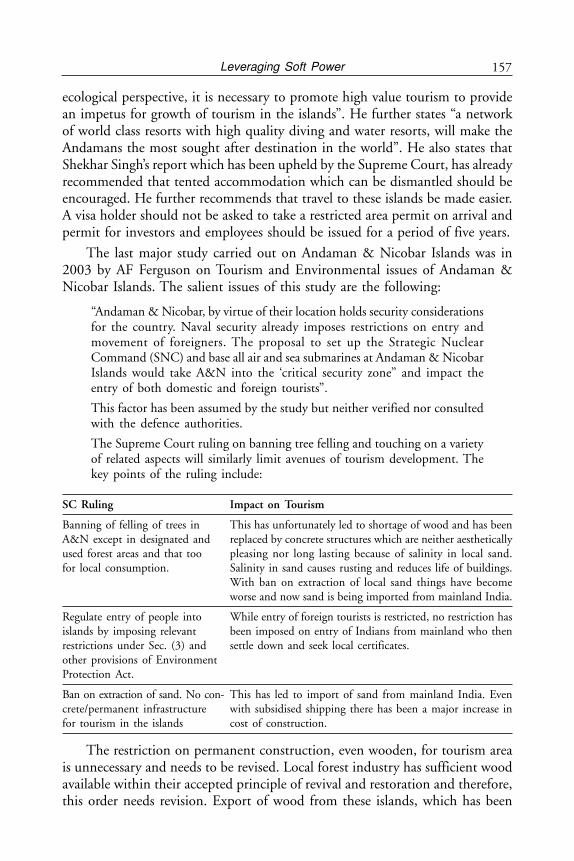
157Leveraging Soft Power
ecological perspective, it is necessary to promote high value tourism to providean impetus for growth of tourism in the islands”. He further states “a networkof world class resorts with high quality diving and water resorts, will make theAndamans the most sought after destination in the world”. He also states thatShekhar Singh’s report which has been upheld by the Supreme Court, has alreadyrecommended that tented accommodation which can be dismantled should beencouraged. He further recommends that travel to these islands be made easier.A visa holder should not be asked to take a restricted area permit on arrival andpermit for investors and employees should be issued for a period of five years.
The last major study carried out on Andaman & Nicobar Islands was in2003 by AF Ferguson on Tourism and Environmental issues of Andaman &Nicobar Islands. The salient issues of this study are the following:
“Andaman & Nicobar, by virtue of their location holds security considerationsfor the country. Naval security already imposes restrictions on entry andmovement of foreigners. The proposal to set up the Strategic NuclearCommand (SNC) and base all air and sea submarines at Andaman & NicobarIslands would take A&N into the ‘critical security zone” and impact theentry of both domestic and foreign tourists”.
This factor has been assumed by the study but neither verified nor consultedwith the defence authorities.
The Supreme Court ruling on banning tree felling and touching on a varietyof related aspects will similarly limit avenues of tourism development. Thekey points of the ruling include:
SC Ruling Impact on Tourism
Banning of felling of trees in This has unfortunately led to shortage of wood and has beenA&N except in designated and replaced by concrete structures which are neither aestheticallyused forest areas and that too pleasing nor long lasting because of salinity in local sand.for local consumption. Salinity in sand causes rusting and reduces life of buildings.
With ban on extraction of local sand things have becomeworse and now sand is being imported from mainland India.
Regulate entry of people into While entry of foreign tourists is restricted, no restriction hasislands by imposing relevant been imposed on entry of Indians from mainland who thenrestrictions under Sec. (3) and settle down and seek local certificates.other provisions of EnvironmentProtection Act.
Ban on extraction of sand. No con- This has led to import of sand from mainland India. Evencrete/permanent infrastructure with subsidised shipping there has been a major increase infor tourism in the islands cost of construction.
The restriction on permanent construction, even wooden, for tourism areais unnecessary and needs to be revised. Local forest industry has sufficient woodavailable within their accepted principle of revival and restoration and therefore,this order needs revision. Export of wood from these islands, which has been
Andaman and Nicobar Islands158
banned, is acceptable but within the islands use of local wood should beencouraged instead of use of cement concrete used as building material.
A major lacuna of this study as well in the Supreme Court order has beenthat there has been no interaction with the defence authorities. The islands arenot only environmentally fragile but sensitive from a security perspective. TheSupreme Court has not consulted defence and security agencies in passing thisorder.
Further, this study has not considered all the islands, specially the far offremote islands where development of a tourist resort to show presence is important.This can be considered as a security requirement where tourists will complimentsecurity and enhance Indian presence. This will also provide a cheaper optionthan having a police post. In a couple of remote islands the police has openedposts with a few men. A special ship goes every couple of months to providerations etc. to the men posted. The expenditure on this is substantial and can besaved. A comparison can be made with the strategy followed by Government ofIndia in the 1970s when they settled 300 ex-servicemen with families in thenisolated Great Nicobar Island for securing the far off territory. In a similar manner,India should now open up tourism resorts in remote islands to exhibit its actualpresence without permitting any new settlements. This will also provide muchneeded surveillance without additional cost of security setup.
During the Author’s discussions with Lt. Governor of Andaman & NicobarIslands and the Commander-in-Chief of Andaman and Nicobar Tri Command(CINCAN) there appeared to be openness on the idea of tourism in remote anduninhabited islands. Further, it was felt that there is a need to show presence insome uninhabited islands. This can be best achieved if India allows some eco-friendly resorts of three, four or five star status to come up in selected locationwith all environmental safeguards including of waste disposal etc. Few of theseresorts may even require some incentives or subsidies to open up. Tourism andForest Departments of Andaman & Nicobar Islands may consider such a schemein consultation with defence authorities. With amphibious aircrafts,communications to such cut off and remote islands should not be a problem,especially during good weather. Already one such aircraft is taking tourists to afew destinations.
Another aspect which has been mentioned earlier is the stand taken byGovernment of India to not to allow uninhabited islands for development oftourism. It was a policy driven by the Intelligence Bureau of MHA not to allowopening of uninhabited islands for tourism under a mistaken belief that touristsand foreign tourists, in particular, can be a liability rather than an asset. WhenMadhavrao Scindia visited the Andaman Islands in 1992-93 as Minister ofTourism he found it very difficult to convince the IB that there is a need to openup uninhabited islands to foreign tourists. Maldives in the Indian Ocean had
159Leveraging Soft Power
taken a diametrically opposite view and did not allow foreign tourists in theirislands where there was a settled population in order to avoid conflict of cultures.Instead, they allotted full islands to well-known Resort Hotels who have establishedcredentials as eco-friendly hotels on payment of royalty.
There is very little appreciation in India of the fact that its marine wealth isgetting poached from its EEZ running into a couple of hundred million dollars.With poaching becoming sophisticated with mother ships and strollers with longnets which can collect huge quantities in a single season, the wealth of India’sEEZ is getting eroded.
Professor Aprajit Biswas of Centre of African Studies, University of Mumbaiin an article on Small Arms and Drug Trafficking in the IOR has shown howAndaman & Nicobar Islands has been used by drug traffickers, ISI of Pakistanand LTTE of Sri Lanka. The potential complementarity between security,environment and tourism needs to be studied in a holistic manner for Andaman& Nicobar Islands. While security is paramount but environmental protectionis equally important. There is a need to fine tune the meeting ground of securityand environment and shows how controlled eco-tourism can complement theneeds of security and environment of these islands. Once security becomes lax,as it is today, with insufficient surveillance over the 572 islands and islets, theencroachment that starts to take place without the knowledge of the authoritiesby illegal immigrants leads to degradation of forests and environment. Since manyof these islands and islets are not visited by the government authorities for yearsthere is no way of finding out the encroachment. The lower functionaries ofgovernment, be it tehsildars of revenue department or forest inspectors do nothave any independent means of transport between islands and activities on someuninhabited islands goes unreported. The example of Myanamarese fishermencollecting sea cucumbers illegally in these islands even these days and havingpermanent hideouts for spares and equipment in uninhabited islands has beenmentioned earlier. Such hideouts are serious security threats. While the MHAremains conservative, the military has now realised that opening the islands totourism is advantageous from a security point of view. There is a need to reconcilethese two views.
The degradation done by illegal immigrants and low end tourists is far moredamaging than that done by high end tourists. This is so because high valuetourists are far more eco-conscious than low value tourists or illegal immigrantsand can be better regulated. Further, low end hostels, one or two star hotels donot have the facilities, funds or even the desire to manage sewage and wastewhich is necessary. Further, locating resorts in inhabited islands can easily leadto conflict of cultures and its consequences. Creating high-end resorts inuninhabited islands will have its virtues and potential intelligence gathering toensure that nothing anti-national or illegal happens.
Andaman and Nicobar Islands160
It is unfortunate that the existing master plan of 2003 is a very restricted oneand has considered only the following islands. The locations covered as part ofthe study included only:
• Port Blair• Havelock• Baratang• Rangat• Mayabunder• Diglipur• Little Andaman• Nicobar District
The study covered hitherto uncovered destinations like Little Andaman, CarNicobar, Katchal and Great Nicobar.
Environment Conundrum becoming a Deterrent toSecurity and Tourism
Two recent issues show how powers provided under Environment Protection Actshave become a deterrent to security and tourism. First is the case of NarcondumIsland (already discussed earlier), where the navy has been refused from settingup a radar due to a population of about 300 Hornbill birds which are, perhaps,endemic to the island. The second is the case of land allotment to a leading FiveStar group for a resort in Havelock Island under a duly approved scheme andwith proper process. Having got the land for the resort they are unable to doanything with it as the rules regarding coastal regulation changed which makesit difficult for them to construct. When the tender was issued rules provided forno construction up to 250 metres of high tide line. After the award of the tender,the rules changed and disallowed any construction up to 500 metres of hightide line. This will lead to respectable hoteliers with a good and environmentfriendly record shying away and unscrupulous entrepreneurs taking over.Inconsistency of government policy and frequent changes in it is of course thebane of India’s economic model and applies to Andaman &Nicobar Islands also.
Environmental Issues
There are 27 forest and environment related legislations/regulations/notifications/plans etc. applicable in the Andaman & Nicobar Islands which are as follows:
The rules, regulations, instructions, manuals and records, held by it or underits control or used by its employees for discharging its functions.
Department of Environment and Forests of ANI is primarily concerned withthe implementation of policies and programmes relating to conservation of bio-diversity, forests and wildlife for enhancement of human well-being. The objectives
161Leveraging Soft Power
of the Department of Environment and Forests, A&N Administration aresupported by legislative and regulatory measures aimed at the preservation,conservation and protection of the forest and environment. The importantlegislations are:
(i) The Indian Forest Act, 1927.(ii) The Andaman & Nicobar Islands Fisheries Regulation, 1938.
(iii) The Andaman & Nicobar Islands (Protection of Aboriginal Tribes)Regulation, 1956.
(iv) Andaman & Nicobar Islands Forest Produce Transit Rules, 1966.(v) Public Premises (Eviction of Unauthorised Occupants) Act, 1971.
(vi) Public Premises (Eviction of Unauthorised Occupants) Rules, 1971.(vii) The Wildlife (Protection) Act, 1972.
(viii) The Wildlife (Protection) (Andaman & Nicobar Islands) Rules, 1973.(ix) The Andaman & Nicobar Forest Department Code, 1973.(x) The Andaman & Nicobar Islands (Wildlife Transit) Rules, 1976.
(xi) The Forest (Conservation) Act, 1980.(xii) The Environment (Protection) Act, 1986.
(xiii) Andaman & Nicobar Islands Protected Forests Rules, 1986.(xiv) The National Forest Policy, 1988.(xv) The Coastal Regulation Zone Notification of 1991.
(xvi) Environmental Impact Assessment Notification, 1994.(xvii) National Eco-tourism Policy, 1998.
(xviii) National Forestry Action Plan (NFAP), 1999.(xix) National Forestry Research Plan (NFRP), 2000.(xx) The Coimbatore Charter, 2001.
(xxi) National Wild life Action Plan, 2002.(xxii) The Biological Diversity Act, 2002.
(xxiii) Forest (Conservation) Rules, 2003.(xxiv) The Biological Diversity Rules, 2004.(xxv) Resolution on Joint Forest Management, 2005.
(xxvi) A&N UT Biodiversity Strategy and Action Plan, 2005.
Such a maze of legislation and policy directives can hardly be conducive toa pro-active approach. What is needed is to produce a comprehensive freshlegislation which will take into account all the above legislation, allow a singlewindow service and sort out the conflicts that take place within this maze.
The following four are the main legislations which control the environmentissues of these islands and which require that most development activities shouldtake place within its purview:
1. Forest Conservation Act,2. Environment Protection Act,
Andaman and Nicobar Islands162
3. Coastal Regulation Act, and4. Protection of Tribals Act.
The Forest and Environment Department of Andaman & Nicobar Islandshas to work within these Acts and all tourism related activities must fall withinthem.
82 per cent of Andaman & Nicobar Islands is under declared forest landwhile about 90 per cent of land is under green cover based on satellite pictures.Within the declared forests there are three categories as follows:
1. National Parks2. Sanctuaries3. Reserve Forests
These three categories take away 7,000 sq km of land surface out of 8,249 sqkm. While it may be difficult to go in for tourism activities in national parksand sanctuaries, reserve forests do allow limited use for eco-tourism. However,the Forest Department of Andaman & Nicobar Islands has as yet no plans fordevelopment of tourism inside reserve forests which is a practice worldwide. Oncethis issue is sorted out there is possibility of limited high end eco-friendly tourismin remote locations. Worldwide reserve forests have been developed for eco-tourism under certain rules and guidelines which are strictly followed. Wildlifesanctuaries like Kruger National Park also have enclaves for tourists where theycan stay under strict rules of not making noise or throwing garbage etc.
Tourism Development
According to the 2003 report the position of land availability for Tourism Resortbuilding is as follows:
Total no of islands/islets 572After deducting small islets, rocks 160Islands with non-forest lands 24Less exclusive tribal reserves 11Areas available for development 13
Small islets and rocks have been left out. However, sometimes these can be goodfor development of resorts. Further, a tribal reserve area like Nicobar can certainlyhave controlled tourism which will be discussed later. And lastly, there shouldbe no bar on developing eco resorts in reserve forests as is being done worldwideas long as it conforms to some guidelines which are properly enforced. Even theSupreme Court has endorsed this view after accepting the Shekhar Singh reportmentioned earlier.
163Leveraging Soft Power
DRAFT TOURISM POLICY
The main features of the existing tourism policy are as follows:
Policy Comments by author
I. Vision To develop the Andaman & Nicobar A good vision but does not restrictIslands as a unique eco-friendly tourist itself to high value tourism as orderrddestination and simultaneously to generate by the Supreme Court.revenue and employment for local youth.
II. Mission The Tourism policy of Andaman & Nicobar There is no mention of high valueIslands aims to promote tourism by develop- and low volume tourism. Carryinging eco-friendly tourist infrastructure of capacity of the islands has beeninternational standards through public and mentioned but does not indicateprivate sector initiative (taking into account whether it will high value only.the carrying capacity of the islands andlimited support infrastructure) for generat-ing local income & revenue and localemployment.
III. SWOT Based on the SWOT analysis in the followinganalysis paragraphs, it will be the policy of the Depart-
ment to leverage the strengths and explore theopportunities, while at the same time addressingthe weaknesses and being prepared for thethreats inherent in this location.a. Strengths
• Large number of good, sandy and safe Andaman & Nicobar Islands dobeaches, beautiful meandering mangrove not have long beaches like Goa.creeks, lush green forests. There is also an emerging croco-
dile problem which needs to bechecked.
• Variety of flora, fauna, including tropical Andaman & Nicobar Islands offerforests and coral reefs. one of the best variety of coral
reefs. This is a major tourist extra-ction and is also eco-friendly.
• Unique tourist spots not available on the Forests trails and treks attract amainland, such as mud volcano and only lot of specialised tourists.active volcano i.e. Barren Island etc.
• Not much variation in climatic conditions, Not correct. There is eight monthsthus facilitating a year-round tourist season. of rainy season and four months
dry season. However, monsoon canbe sold as a special attraction too.
• Communal harmony. Correct. No communal tension orcrime.
• No crime or anti-social activities.• Unexplored Destinations. A very important issue. Because of
a large number of uninhabitedislands the tourism potential foropening of new islands overtimeand thereby offering newdestinations is very high.
Andaman and Nicobar Islands164
b. Weaknesses• Distance from the mainland. These islands are closer to South-
East Asia like Phuket which is amajor tourist destination. Onlydirect flights from South East Asiaare wanting. Incidentally, there isan agreement of Friendship/Cooperation with the City of PortBlair and Phuket Province ofThailand signed in Phuket on June29, 2005 which talks of exchangeof tourists, education, solid wastemanagement but there has been noimplementation of this agreementas yet.Direct international flights fromPhuket, Bangkok and Singaporecan cut down the cost.
• Lack of basic tourism infrastructure. Very correct. A good airport atPort Blair exists. A new terminalwill come up by 2015. AirstripsDiglipur and Campbell Bay need tobe lengthened, Car Nicobar is fine.Scuba diving with live-on-boardfacility has great potential butnothing being done. Uninhabitedislands should be opened. No boatof reasonable quality available forthis purpose or for deep sea fishing.
• Lack of adequate accommodation both in Serious issue with MoEF as theyterms of numbers as well as categories. keep changing their policy.
Example: After auctioning of abeach site for a resort, the MoEFhas changed its policy of coastaldevelopment. Further, only highvalue accommodation needs to beallowed as per Supreme Court’sorder.
• Uncertainty amongst potential investors Serious issue with MoEF.about future tourism scenario. Example: After auctioning of
beach site for a resort, the MoEFhad changed its policy of coastaldevelopment.
• Poor inter-island connectivity, Lack of Andaman & Nicobar Islandsavailability of speed boats, helicopter and should also consider leasing outother faster modes of transport for tourists. inter-island ferries and air routes
under their supervision with orwithout subsidy.
Policy Comments by author

165Leveraging Soft Power
• Investors find it difficult to obtain clearance Poor infrastructure connectivityfor tourism related projects from different discourages private investment. Nodepartments in the absence of single direct international flights despitewindow system for clearing tourism Port Blair being an internationalprojects, high cost of development of airport.infrastructure.
• Huge expenses on travelling. Unless direct international con-nectivity is provided from South-East Asia this problem will remainas domestic flights in India areexpensive. The subsidy provided toshipping could be reduced andsubsidy could be given to airservices as was done for Haj Travelin India.
c. Opportunities• Scope for promotion of adventure sea sports The administration has even shut
down the Scuba Diving Societystarted by it in 1992. This needs tobe started by Andaman Administra-tion. No encouragement to privatescuba operators. No adventurecampaign carried out by Andaman& Nicobar Islands in spite ofadequate funds like in Kerala.
• Marketing unexplored destination No campaign has been started.Lessons to be learnt from Keralaexperience.
• Leisure tourism Negligible due to scarcity of hotels.• Game fishing Very high scope however no effort
by the administration.• Coastal threat and jungle trekking Same as above.• Creek Cruise Tourism No efforts by administration. New
problem of crocodiles.• Meetings, Incentive Conferences Infrastructure not sufficient.
and Events (MICE) Not encouraged.• Cruise Tourism Foreign cruise ships have come to
Port Blair earlier. In 1992, theycame and were invited to LGsHouse for tea. Next year somehow,they were not encouraged onsecurity grounds and they havereduced coming.
• Medical Tourism Proposal to setup a super specialtyhospital by a well known privatesector company, who were alsoallotted land by local administra-tion, was turned down by MHA.
Policy Comments by author
Andaman and Nicobar Islands166
IV. Objectives Deriving from the Mission, it is the stated There is hardly any visibility onobjective of the A&N Administration to this end. Port Blair Town and otherpromote sustainable tourism in the Andaman areas are full of open garbage.& Nicobar Islands in such a way that it would There is no policy for garbage dis-generate local employment and contribute to the posal for wet and dry garbage. Sustain-economic growth of this Union Territory with- able tourism policy should emphasiseout bringing imbalance in flora & fauna and on high value tourism only.also without adversely affecting the carryingcapacity of these islands. To this end it wouldendeavour to:
i. Promote Eco-tourism with a view to Fortune Bay Island Hotel run byprotect the fragile eco-system. ITC hotels at Port Blair has done
an excellent job in waterconservation. They also use seawater for all their flushing andrecycle it. They also harvest rainwater which is sufficient to meettheir requirement during the leanperiod. This and other goodpractices need to be duplicated forall other hotels as a model practice.
ii. Create self-sustainable jobs for the local Tourism will bring demand foryouth of these islands. skilled people. Hoteliers in Port
Blair have expressed their unhappi-ness at the lack of availability ofskilled youth and they are beingforced to import hotel staff frommainland at a higher cost.
iii. Generate substantial revenue for A & N Tourism activities will generateIslands and project a friendly tourist such revenues. However, as perimage to the world at large and make Supreme Court Judgment, onlythis union territory one of the best tourist high end tourism to be allowed anddestinations. there is no need to encourage mass
tourism.iv. To be the number one Indian destination Only high end tourism to be
by per capita market share of visitor’s encouraged as per Supremeexpenditure. Court’s order.
v. Encourage domestic tourism with a view No. This will lead to mass tourismto provide to the people of the country which is not permitted as perthe unique feature of unity in diversity, Supreme Court’s order.secularism—a perfect example of nationalintegration.
vi. Offer opportunities to the youth not only Introduce items like Internationalfor employment but also for taking up Award for Young People Programmeactivities of nation building character. (IAYP) for character building in
schools and colleges.vii. Bring socio-economic benefits to the people Tourist demand for vegetables in
of these islands. Andaman Islands has been metfrom Islands of Haveloc and Neiland has benefited the local people.
Policy Comments by author
167Leveraging Soft Power
Availability of fish is also met bylocal catch.
viii. Preserving and enriching our cultural Cellular jail and Ross Island needsheritage in all its manifestations further restoration.and causing accretion and strength ratherthan degrading social and cultural values.
ix. Develop places of interest as tourist desti- A mustnations. The uniqueness of features suchas mud volcano, the potential of beachessuch as at Havelock and Neil Islands foracqua sports, the peace and tranquilityof the back waters would be developedin their own light.
x. Provide quality services to all domestic Only high end tourism to beand international tourists. allowed.
xi. Diversify and expand the marketing of the Yes but in the Nicobar Islandsislands’ tourism potential while preserving allow only tribals to developits fragile ecosystem. tourism.
xii. Encourage people’s participation in tourism This would be more appropriate inrelated activities so that it is community- the Nicobar Islands. However, inbased, thereby generating synergies between Andamans only well establishedguests and locals. Some such roles for the hotel chain with green tourismlocal community could be to run paying background should be encouraged.guest accommodation, house-boats etc.
xiii. Focus on promotion of international tourism Yes. MOU signed between Lt.by including these islands in the South East Governor and Governor of PhuketAsian packages offered by tour operators lying unimplemented.from the West and Japan, Australia etc.
xiv. To develop world class infrastructure i.e. Invite tour promoters, leadinghotels, resorts, connectivity by road, air, hotels on familiarisation tours.ship etc to cater to the demand of foreigntourists.
xv. Encourage the private sector, including Last allotment of land to hotelsinternational corporates, to invest in was a disaster as after allotmenttourism related projects, through FDI, major change in Coastal Regulationeither fully owned or in collaboration was done.with Indian partners, either private orgovernmental, as per the prevailingenactments.
xvi. To encourage traditional artisans and the Agreed.handicraft sector
V. Strategy The Government will have to withdraw from Government to sell privatisedits present role as a tourism-service provider, hotels.but steadily perform as a facilitator and regulator.It would be required to provide support andinfrastructure facilities such as tourist informationcentres & kiosks, facilities for holding Conventionsfor MICE, drawing up an annual calendar ofevents, transportation services etc.
Policy Comments by author
Andaman and Nicobar Islands168
The draft tourism policy of Andaman & Nicobar Islands contains all theingredients of a policy which is populist but does not give direction nor does itprovide the relationship between forest lands and development of tourism. Italso does not seem to be aware of the Supreme Court directive of high value lowvolume tourism policy. A reality check gives an entirely opposite picture. Thepresent inter-island infrastructure of ferries is old and inefficient. One sea planehas been leased by the administration recently to run a service between theseislands with differential tariff rates for islanders and visitors. The same type of seaplane was purchased in 1993 but it met with an accident and was not replaced.Anyhow, this is a good beginning and this would go a long way to improveinter-island connectivity. A Scuba Diving Society was set up by the administrationin the early nineties but was allowed to waste away due to bureaucratic indifference.Luckily, private scuba diving centres have since come up but their charges aresubstantially higher than those in Thailand.
Tourism policy mentioned with other government departments/agencies:
The Environment and Forest Department website mentions eco-tourism inits introduction as follows:
“Mother Nature has been extra generous to Andaman & Nicobar Islands inendowing it with phenomenally rich biodiversity which is displayed in itsvaried assemblage of flora and fauna on land and in water surrounding theislands. Their uniqueness lies in high degree of endemism, particularly, infauna. Forests cover about 84 per cent of the islands’ geographical area.”
Andaman & Nicobar Islands is also a great attraction for bird watchers aswell as for its rich, unique and endemic bio-diversity. As many as 270 speciesand sub-species are reported by ornithologists. These islands are part of the 218Endemic Bird Areas (EBA) of the world. Its mangrove vegetation protects theseislands from soil erosion. Its wildlife consists of wild pigs, dugongs, elephants,turtles, snakes. Coral reefs, sea cucumbers, and shells of various types form partof marine wild life. It has 96 wildlife sanctuaries, nine national parks and onebio-sphere reserve. This can be a great attraction for nature loving tourists onlyif facilities for stay are provided and tours under control conditions are mademandatory.
Another place where we find mention of tourism as an objective is in thewebsite on Andaman & Nicobar Integrated Development Corporation(ANIIDCO). This public sector entity is supposed to facilitate industry, fisheriesand tourism as a common objective. It states:
ANIIDCO was set up in 1988 at the instance of IDA with the objective todevelop and commercially exploit the nature resources of the territory forthe balanced and environmentally sound development of the territory. TheANDIICO which is a fully government owned corporation, undertakes awide range of departmental activities such as tourism, fisheries, supplies,marketing, industries and finance under one umbrella.
169Leveraging Soft Power
Tourism
The basic objective of the tourism division is to develop, operate and maintainthe tourism infrastructure. It has one tourist guest house, the Megapode Nestand a number of catering units and restaurants. Efforts are being made to ensurebetter maintenance of tourist lodges, recreational facilities and develop shoppingcentres at the tourist points/places. The tourism section of the Andaman &Nicobar Islands is poised for significant growth and it has to play a catalytic rolein creating and maintaining the tourism infrastructure along with the otheragencies. However, it should get out of managing resorts which it is unable todo mainly because of governmental rules and regulations. It also does not mentionwater based activities like scuba or deep sea fishing.
It is unfortunate but ANIIDCO has not been able to provide any quality inits management. Its facilities can best be judged as three stars or less.
Fisheries
The corporation has started this division for commercial exploitation ofabundantly available fish in the Andaman & Nicobar Islands, and to providegood marketing network to the local fisherman. A subsidiary company namelyM/s. AFL, the first 100 per cent Export Oriented Unit (EOU) in the Andaman& Nicobar Administration has been promoted by Andaman & Nicobar Islandswhich has recently gone into commercial production. The potential for deep seafishing is immense. However, on ground there does not appear to be any actualimprovement. The coastline of all the islands adds up to 1,962 km in length. Itis bordered with luxuriant mangroves and magnificent coral reefs on the fringes.
A clean and pollution-free environment and lush green forests of the islandssurrounded by blue sea water should make Andaman & Nicobar Islands one ofthe most favoured destinations for eco-tourism in the world. However, this isnot so. The poor quality of infrastructure and in addition, the increasingpopulation of crocodiles in the beaches and creeks is a cause of concern. Crocodilesbreed very fast and the ban on their killing is making it more difficult to encouragetourism. There is need to review the ban on killing of crocodiles as it is leadingto attacks by them on human beings and many people have died and lost limbswhile swimming. Notices at beaches to beware of crocodiles is driving away touristsfrom the beaches.
What we see is confusion of the administration in developing tourism whichdoes not provide a philosophy or quality control. Should the island’s fragileenvironment allow mass tourism or restricted tourism? Should the variousuninhabited islands be allowed to open up resorts? Should India encourage shipbased low value tourists (This does not include high value cruise ships) or restrictit to high value only? These questions need to be answered in a policy and aphilosophy statement.
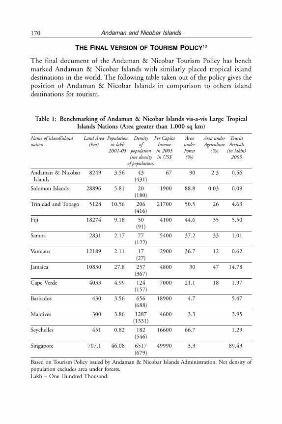
Andaman and Nicobar Islands170
THE FINAL VERSION OF TOURISM POLICY10
The final document of the Andaman & Nicobar Tourism Policy has benchmarked Andaman & Nicobar Islands with similarly placed tropical islanddestinations in the world. The following table taken out of the policy gives theposition of Andaman & Nicobar Islands in comparison to others islanddestinations for tourism.
Table 1: Benchmarking of Andaman & Nicobar Islands vis-a-vis Large TropicalIslands Nations (Area greater than 1,000 sq km)
Name of island/island Land Area Population Density Per Capita Area Area under Touristnation (km) in lakh of Income under Agriculture Arrivals
2001-05 population in 2005 Forest (%) (in lakhs)(net density in US$ (%) 2005
of population)
Andaman & Nicobar 8249 3.56 43 67 90 2.3 0.56Islands (431)
Solomon Islands 28896 5.81 20 1900 88.8 0.03 0.09(180)
Trinidad and Tobago 5128 10.56 206 21700 50.5 26 4.63(416)
Fiji 18274 9.18 50 4100 44.6 35 5.50(91)
Samoa 2831 2.17 77 5400 37.2 33 1.01(122)
Vanuatu 12189 2.11 17 2900 36.7 12 0.62(27)
Jamaica 10830 27.8 257 4800 30 47 14.78(367)
Cape Verde 4033 4.99 124 7000 21.1 18 1.97(157)
Barbados 430 3.56 656 18900 4.7 5.47(688)
Maldives 300 3.86 1287 4600 3.3 3.95(1331)
Seychelles 451 0.82 182 16600 66.7 1.29(546)
Singapore 707.1 46.08 6517 49990 3.3 89.43(679)
Based on Tourism Policy issued by Andaman & Nicobar Islands Administration. Net density ofpopulation excludes area under forests.Lakh – One Hundred Thousand.
171Leveraging Soft Power
From the above chart it may be seen that Andaman & Nicobar Islands hasthe highest percentage of forests at 90 per cent of land surface and lowest percentageof agriculture. This figure should be seen as an advantage as eco-tourism withdense forests and beaches is a preferred option with eco-tourists. In fact, the highlevel of forest reserves gives Andaman & Nicobar Islands a special place for naturerelated activities and reduces the pull of social resort tourism. Forest area has anumber of restrictions which have to be honoured and generally allow only upmarket tourism because of these restrictions. Worldwide forest tourism in reservesis becoming popular. However, Andaman & Nicobar Islands have no forest relatedtourism especially when the forests of Andaman & Nicobar Islands are extremelydense rain forests rarely found in the world today.
Andaman & Nicobar Islands do not have any major animals in the forestwhich are likely to be hunted. There are iguanas, other reptiles and birds. Thelist of protected species has already been listed by the Forest and EnvironmentDepartment. Unlike forest departments in countries like US, Australia and NewZealand and even some forest departments of Indian States, there has been verylittle work done by the Forest Department to promote eco-tourism in the forestareas. There is a need to plan out the high quality of the limited number oftourists resorts inside these forests. There is a growing breed of nature lovers whotravel to all corners of the world to such locations. It will not only be a revenueearner but also bring awareness of the environmental degradation happeninginside, if any.
The Tourism Policy document issued by the Andaman & Nicobar Islandsclearly states in its strategy to go in for Strategic Partnerships. It states, ‘Formulatestrategic tourism partnerships with neighbouring international destinations likePhuket for leveraging increased visits to these islands.’ So far no such partnershiphas been signed or even negotiated. The only document is the MOU signedbetween the Lt. Governor of Andaman & Nicobar Islands and Governor of Phuketsigned in 2005 but which remains unimplemented. This is unfortunate as thisagreement talked of tourism promotion, solid waste management and culturalexchanges amongst other things. (See Appendix 3)
In order to compare tourism policies of other countries, given below is acomparison with Bhutan, South Pacific Islands based on a UN Report, theMaldives Model and Report of Ecotourism Association of Australia (EAA).
COMPARATIVE TOURISM POLICIES OF SELECTED COUNTRIES
Tourism Development in Bhutan: High Value-Low Volume Tourism Policy
It goes to the credit of The Royal Government of Bhutan that they were awarethat unrestricted flow of tourists can have negative impacts on Bhutan’s pristineenvironment and its rich and unique culture. The government, therefore, adopteda policy of “High value-low volume” tourism, controlling the type and quantity
Andaman and Nicobar Islands172
of Tourism right from the start. Until 1991 the Bhutan Tourism Corporation(BTC), a quasi-autonomous and self-financing body, implemented thegovernment’s tourism policy. All tourists, up to that time came as guests of BTC,which in turn operated the tour, transport services and nearly all the hotels andaccommodation facilities. The government privatised tourism in October 1991to encourage increased private sector participation in the tourism sector. Today,there are more than 75 licensed tour operators in the country.
What Bhutan insists on is a minimum payment/spend by a tourist per daywhich is about US$ 200.This might vary from high to low season but it acts asa filter to discourage low value tourists who add to volumes but not revenues andmay cause environmental damage. This strategy adopted by Bhutan is workingwell as it keeps this sensitive area free of ill effects of pollution and degradationwhich comes with low end tourism.
Tourism Development in South Pacific Islands
Ecotourism is a concept that describes a form of development that respectstradition and culture; protects and preserves the environment; and educates andwelcomes visitors. In addition, ecotourism should be sustainable economicallyover the long-term. In American Samoa, this definition is intended to defineecotourism at the national and local level.
A UN Report on tourism in South Pacific has come out with policyrecommendations for ecotourism.
The government adopted a definition of ecotourism that was further developedby the Pacific Business Centre at the University of Hawaii.
The American Samoa National Park was established by the United StatesCongress in 1988. This makes the park part of the US National Park System(NPS). However, the national park became a reality only after lease agreementswere signed by all village councils within the park area. The park stretches overmore than 6,000 acres and includes the islands of Tatuila and Manu’a, as well asthe beaches of Ta’u and Ofu Islands. Tourists to the national park can join homestay programmes to experience the typical Samoan village life. There is also hiking,diving and traditional fishing as part of village activities. There are also educationaland recreational ecotourism tours that include observing marine and wildlife,learning about traditional and medicinal plants and exploring archaeological andhistorical sites.
Mass tourism is considered the main threat to the sustainability of ecotourism,especially since the environment in the national park is so fragile.
There is a national park staff trained to counteract some aspects of this threat.For example, they monitor tourist activities and educate villagers about usingthe park site for low impact tourism development. Home stay programmes areencouraged and initiated instead of hotel development. Villagers are able to
173Leveraging Soft Power
coordinate tours rather than face the risks presented by group tours. Educationaleco-tours are also promoted.
The Maldives Model
The Maldives is an archipelago in the Arabian Sea/Indian Ocean which hasevolved into a high end eco-friendly tourism destination. In its environmentalregulations and standards for the tourism sector, it has adopted certain principleslike maximum built up area to be restricted to 20 per cent of land mass.Reservation of aesthetics, integrity of the resorts, with height restricted to theheight of vegetation, with as much use of local material as possible. Whileconstruction on reefs and lagoons was discouraged, but as water side bungalowsare very popular amongst tourists, their construction is permitted if equal sizeopen space is left on the land for each bungalow being developed on the lagoon.
Australian Model
Formed in 1991, the Ecotourism Australia serves as the apex national body forAustralia’s ecotourism industry. Currently, EAA has approximately 500 members,publishes an annual Australian Ecotourism Guide, and hosts an annualconference. In addition to strengthening the industry network of ecotourismoperators, the EAA actively promotes “best tourism practices” through self-regulation and accreditation. Attracting high value visitors in order to develop amore profitable tourism industry rather than just pursuing growth in visitornumbers should be the goal according to Ecotourism Australia.11
To provide tourists and the travel trade with a recognisable and authenticecotourism product, the Ecotourism Australia initiated the National EcotourismAccreditation Programme (NEAP) in 1996 in cooperation with the AustraliaTourism Operators Network (ATON) and the Tourism Council of Australia,with funding support from the Office of National Tourism. In 2000, thecertification programme changed its name to the NEAP. Under NEAP, productsawarded ecotourism accreditation are required to meet a comprehensive set ofcore criteria based on ecological sustainability and minimum environmentalimpact. At this stage, NEAP mostly relies on a self-assessment procedure andfour forms of monitoring measures, including random on-site audits. In addition,NEAP requires periodic monitoring and management review for accreditedecotourism operators to ensure continuous improvement of standards. Australiangovernment supports EAA.
Challenges and Opportunities
The development of ecotourism in Australia is still in its infancy, withapproximately 600 ecotourism operators (mostly small in size), providing anequivalent of 4,500 full-time jobs and Aus $250 million turnover. Although a
Andaman and Nicobar Islands174
plethora of plans and strategies are being developed in Australia to promoteecotourism, the long-term effectiveness of these newly formed programmes andinitiatives has yet been evaluated. To contribute towards sustainable development,these initiatives must be able to move ecotourism beyond simply a niche marketwithin nature-based travel. Ecotourism must serve as a vehicle to transformunsustainable mass tourism practices towards genuine “greening,” not just “greenwashing” of the tourism industry. In a highly competitive marketplace, theecotourism industry is likely to face immense challenges to live up to the promiseof sustainable tourism.”
A Policy Prescription for Positive Discouragement of Mass Tourism
It may be seen from above examples that Andaman & Nicobar Islands also needto come out with more detailed policy guidelines and regulations for their tourismpolicy. Its policies have to be compliant to the Supreme Court’s order which isvery clear on high value-low volume tourism. While it has identified activitiesfor tourists such as scuba diving, cruise tourism, canopy walkway, mass tourismwill be a spoiler. As already pointed out in the case of Bhutan, Maldives, SouthPacific Islands and Australian tourism, mass tourism can lead to the destructionof the environment, especially if enforcement is weak. India has already seendegradation of the environment in tourism areas in the Himalayas due to masstourism and lack of enforcement it. The recent 2012 incident reported in allnational newspapers that local tour operators in Port Blair in connivance withpolice have been taking groups of tourists to Jarawa areas and forcing Jarawas todance before them. This is a case in point that how a laid out policy was violatednot only by travel agents but also local administration and police who connivedin this activity. Such activities are proof of poor surveillance and show a needfor a tourism and environmental regulator for these islands. It would be in thefitness of things to decide upfront how to control decline in the quality ofenforcement.
The town of Port Blair is quite shabby because of poor municipal intervention.Maintaining remote locations will be even more difficult. The Bhutan model isperhaps one option. Having kept a minimum expenditure per tourist at aboutUS$ 200 per tourist per day it provides a good filter. Further, there is a need toput minimum requirements on hotels and guest houses for cleanliness and garbagedisposal, both wet and dry. As a matter of fact a minimum ceiling on qualityshould be kept. The existing accommodations should be asked to upgrade sothat in a course of a couple of years this destination becomes a high end destination.Further, in remote locations issues of water availability need to be sorted out.With heavy rainfall concentrated over nine months, water harvesting methodscan be employed. The issue of electricity remains a problem as Andaman &Nicobar Islands are dependent upon diesel generation and so far no majorbreakthrough has been achieved in this area. Diesel generation, with the newtype of silent generators is still polluting. A Hydel project called Kalpong
175Leveraging Soft Power
Hydroelectric Power Project has started functioning since November 2001producing 5.25 MW of Hydel Power by creating a 34 metre high concrete damon Kalpong River.12 This is an exception and cannot be repeated due to terrainfactors.
Infrastructure and Tourism
In order to attract high end tourists minimum quality infrastructure is required.Good air connection, fast travel to islands, clean environment, availability ofclean water, clean beaches, low crime rate all form a part of tourism essentials.Expenditure on these need to come mainly from the government but whereverpossible, private sector participation should be used.
One of the problems of Andaman & Nicobar Islands is shortage of water forabout three months in the year when it is dry there. While there is adequaterainfall, the months from January to March are dry and there is shortage ofdrinking water in most areas. These are also the best tourist months. For promotionof tourism and to supply water during the dry months, there is need for extensiverain water harvesting technology to be applied in all islands and all areas wherepeople live and tourism is to be promoted. This is a solvable problem as there isadequate rainfall rest of the year. Water barrages can be built from one island tothe other during the season, as the sea is also calm during this period.
Responsible Tourism
Responsible Tourism is the current mantra of tour operators. However, it is notenough to allow the slogan but penalties should be kept in the legislation andfines imposed on hotels/guest houses that do not follow it in letter and spirit.Opening of these islands will give a better appreciation to the whole concept ofuse of tourism for security purposes.
Will tourism development improve or further degrade environment? This isa complex question. Mass tourism has shown in many places that it can degradeenvironment if policies are not followed. However, limited high end tourism canimprove the environment. How does one achieve limited high end tourism? Thiscan be achieved if appropriate policies are put in place and implemented. Thiscalls for a philosophy for Andaman & Nicobar Islands.
In the recent order of the Supreme Court banning tourism in core areas oftiger reserves, it said that it was not averse to permitting regulated tourismactivities, subject to revised guidelines to protect the depleting wild cat. It grantedfour weeks to the centre to evolve fresh guidelines after consultation with states,all stake holders, hotel associations affected by the ban, guides and tour operators.
They also stated “There is always a watch when tourism is allowed. If thereis no tourism there will be no human to watch the tigers. Poachers will immediatelybe caught by tourists and guides. Poachers actually work under cover. If no touristsare allowed, it will be a field day for poachers.”
Andaman and Nicobar Islands176
Eco-tourism is a fastest growing segment of the tourism industry. Why is itso? This is so because tourists have shifted away from casino based tourism toenvironmental based tourism. Such tourists are not looking for music, televisionor evening entertainment but are looking for a quiet peaceful time. As a result,many countries, especially forested countries and island countries have issuedguidelines for this specialised tourism. The above is also true for the uninhabitedIslands of Andaman & Nicobar Islands.13
Tribal Policy and Tourism: Opening of Nicobar Islands for Tourism
Andaman & Nicobar Islands Protection of Aboriginal Tribes Regulation, 1956and the Rules framed there under provide the framework of the Tribal Policy.14
There are four tribes in Andaman Group and two in Nicobar. Tribes of Andamanare Jarawas, Adamanaese, Sentinelese and Onges, each residing in a separateregion. The Sentinelese reside in Sentinal Islands which are isolated and they arehostile to other human beings. They are still in hunting and gathering stageand do not want to be disturbed. There is, therefore, no problem with them aslong as they are left alone. The Andamanese were the residents of Port Blairregion about half a century back but are now re-located in Strait Island, shiftedby the British Government. They are about to get extinct with less than 20members left. The Onges are in Little Andamans living under the TribalDepartment’s Welfare Scheme and there is no issue with them. The only conflictof the people is with the Jarawas Tribe which is primitive and lives north of PortBlair where a road called Anadaman Trunk Road (ATR) has cut through theirterritory and is causing a lot of problems for them. This has become a case oflitigation in the court by leading environmentalists. The Supreme Court hadordered closure of a certain part of the road going through the Jarawas reservewhich has not been done as yet. These four tribes are still primitive and theexisting policy to leave them by themselves without allowing tourists to go theirareas is fully accepted and appreciated. There is no need for tourists to have anyinterface with them.
The Nicobars however is another story. The Nicobar Group of Islands hasNicobarese tribals in practically all islands of Nicobar. These are progressive tribalswho have joined the mainstream. Nicobarese boys have been winners of All IndiaSubroto Mukerjee Trophy in Football many times.15 The Nicobarese children areall literate and are attending schools. They are also working in various governmentdepartments including defence forces and are doing well. In fact, according to asenior Nicobarese officer, Nicobarese are now facing issues of educatedunemployment as the children passing out of schools and colleges are not gettingabsorbed in Nicobars and have to seek a living outside their homes.
Another very small group of tribals called Shompens is found in Great NicobarIslands. They are still hunters and gatherers and can be called primitive. Thesetribals are shy and live in the forest areas. Yet they are friendly and come into
177Leveraging Soft Power
settled areas to exchange their products like honey. They should be allowed tolive their own life. They have some contact with the tribal department in theGreat Nicobar Islands but they feel shy to mix with other settlers. There is noproblem with them.
Although, the Tribal Policy of Andaman & Nicobar Islands has insulatedthe primitive tribes (except from some breaches in implementation), the author’sposition is to respect all the restrictions imposed by the Supreme Court and thetribal legislations by the administration except for Nicobars. The Nicobarese havenow reached the stage of development and integration that they need to be moreactively involved with the rest of the country. Further, their main activity in theNicobar Islands is around coconut trade which has suffered due to the tsunamiand reached a saturation point. They need a new economic venue to absorb theyouth, especially the educated youth and a policy of controlled tourism aftertaking into confidence their Tribal Council. Leading Nicobarese have stated thattheir coconut trade has reached a saturation point and they need to start a neweconomic activity. The obvious choice would be to allow growth of tourism inNicobars.
As part of India’s enlightenment policy adopted towards the Nicobarese thereis a need to dialogue with them regarding regulated tourism in these islands. Itis necessary that all decisions are taken after due consultation with their TribalCouncil, which they respect. As the younger generation looks for jobs and isgetting educated, there is a need to allow tourism in these islands but managedby them and not outside companies. They are well organised and capable ofmanaging business themselves.
While the Nicobar Islands are still very remote and isolated, their interactionwith foreign fishermen and traders has always been there prior to 1947. Thegovernment policy since after World War II of prohibiting foreign boats fromentering these islands has made them more insular and isolated. However,reopening these islands to foreign tourists/cruise ships will not be such a majorchange. The island of Car Nicobar is the most progressive of them and is readyto welcome a limited number of tourists. For the rest of the islands cruise shipsstopping for a few hours like in the Greek Islands would be a win-win for boththe tribals and display of soft power.
In conclusion, the scope of leveraging India’s soft power by tourism promotionand allied activities is immense keeping in mind full environmental protection.Not only that, while hard power is a costly drain on the exchequer, soft powerthrough tourism and its allied activities, is revenue generating for the localeconomy, the region as well as for the country. Tourism is now the biggest industryin the world and the share of Andaman & Nicobar Islands is insignificant.However, the need for promoting tourism in these islands should not be forgenerating revenues but for supplementing the LEP and complimenting militarypower with soft power to increase the strategic vision in the national context.
Andaman and Nicobar Islands178
NOTES
1. Joseph S. Nye Jr., Soft Power: The Means to Succeed in World Politics, Harvard University,2004.
2. Rohini Mohan, “The Great Indian Tuna Robbery”, Tehelka, March 03, 2012.3. Judgment dated May 07, 2002 passed by the Hon’ble Supreme Court of India in W.P.
No.202/1995.4. Darren Smith, “National Park Status”, see www.usparks.about.com5. “Green Terror”, India Today, October, 15, 2012, p. 19.6. Jayadev Ranade, “China expanding maritime ambition and growing naval power”, Issue
Brief, August 29, 2011.7. M.H. Ahsan, “Andaman faces Kargil type invasion:, at www.Boloji.com, July 12, 2011.8. Nils Finn Munch- Petersen was a short-term consultant to Andaman & Nicobar
Administration and UNDP. Currently he is working in Bhutan.9. UNDP-WTO project IND/93/032 Shankland & Cox Entec, August, 1996.10. Issued by Directorate of Tourism, Port Blair (undated).11. www.etravelblackboard.com/article136276/focus-on-high-end-tour12. pib.nic.in/feature/feyr2001/fnov2001/f231120011.html13. Indian Express, August 30, 2012.14. Even during the British period there was a trader protection policy in the Nicobars. The
British introduced licenses to trade in the Nicobars, and cancelled all debts of the traders.Please see Chapter 3.
15. The Air Force Station at Car Nicobar often provides them airlifts to the mainland toparticipate in such sporting events as a matter of goodwill.
179Andaman & Nicobar Islands—Strategic Challenges
CHAPTER 10
Andaman & Nicobar Islands—Strategic Challenges:A Proposed Policy Prescription
India’s LEP of 1991 was a major departure in its foreign policy followed up tothat time. However, the LEP remained incomplete without a critical look at therole the Andaman & Nicobar Administration could play in the developingsecurity scenario of the country. The MoD took nearly 10 years to leverage thestrategic advantage offered by these islands by creating a Joint Command in2001. They took another 10 years in announcing a forward naval base calledBaaz at Great Nicobar Islands in 2012. However, the civil side represented byMHA remained indifferent to LEP and continued with the policy of benignneglect and masterly inactivity. Therefore, there is now need for drastic change inthe civil policy towards these islands in view of the new challenges. India is in asimilar state today in the geopolitical context as India was in late 1950s and1960s when China took over Tibet by military aggression while India watchedthem in quiet acquiescence and its borders became common with China. Thepeaceful borders with Tibet became full of tension and remain so even now.Western borders with Pakistan have the problem of terrorism. The all-weatherfriendship between Pakistan and China is yet another known unknown.
The forward policy adopted in 1950s over NEFA gave us effective jurisdictionup to McMahon line and also brought 50 odd tribes of the region into harmoniousdevelopment with affinity towards India. The twin purpose of the policy wasachieved. However, in the western sector of Ladakh, since there was no effectivejurisdiction mainly due to the terrain, the Chinese came into Aksai Chin andhave stayed on since with 35,000 sq km of area under their control. This showsthat effective administration can be used to one’s benefit in international relations.In a similar manner, the Chinese aggressive claims and physical occupation inEast and South China Sea is a reminder of what they did over 60 years back overthe Himalayas and what they are doing now is to increase their influence andeffective jurisdiction to consolidate the claim in South and East China Sea.
Andaman and Nicobar Islands180
INTEGRATING ANDAMAN & NICOBAR ISLANDS WITH LEP
In implementing the LEP enunciated by Prime Minister Narasimha Rao in 1991these islands were completely overlooked for their strategic relevance. While Indiamade moves to integrate with its eastern neighbours in ASEAN and othercountries, the civil administration completely bypassed leveraging the advantagesof having the islands. In the natural order of things, the integration of theseislands with the LEP should have been done at the earliest. The defenceauthorities, however, did take the initiative and created the joint command inAndaman & Nicobar Islands in 2001 after a gap of 10 years.
In such a scenario, India needs to leverage these forgotten assets to itsadvantage. With the recent developments in South China Sea over maritimeboundaries claimed by China on basis of “historic data”, India should seek lessonsfrom it and extend its presence in these islands. This can be done in two ways:(1) India should use its military to fortify these islands and send a message to theworld that these islands not only belong to India but are in full occupation, (2)India should open up these islands as a matter of soft strategy to announce to theworld that Indian territory extends right up to Straits of Malacca.
SOFT POWER OPTION
To complement India’s military strategy India should use the soft power availabledue to these islands. India should open up these islands, which have been keptlocked up due to restrictive policies, by allowing Indian and foreign tourists tovisit in a much greater way. This is similar to what China is doing to the islandswhich it has occupied in South China Sea. It is an effective method of conveyingto the world what is yours. This can be done in two ways, either by settlingIndians from mainland or by encouraging tourism. The fact that these islandshave over 90 per cent forests and are environmentally fragile and many islandsare short of drinking water, the idea of any new settlement cannot be considered.The second alternative of encouraging tourism to uninhabited places also hasits problems. If mass tourism is allowed then there will be impact on the fragile ecosystem and therefore the only possible method is to allow high value-low volumetourism in various islands which also has the approval of the Supreme Court ofIndia. Price as a filter for tourism will determine this aspect. There is also a needto review the Foreigners Restricted Areas Orders of 1963. While these ordersallow a foreign national to stay in these islands for a period of 30 days extendablelocally for another 15 days, anything beyond requires the permission of the MHA.Further, Nicobars are completely prohibited to foreigners and require priorpermission of the MHA.
The Andaman & Nicobar Islands have a unique location for India for theyextend India’s land surface and maritime border right up to the mouth of Straitof Malacca. Leveraging these islands can enhance India’s relationship with
181Andaman & Nicobar Islands—Strategic Challenges
Thailand, Malaysia and Indonesia and also with ASEAN in general. India’spresence in the Andaman & Nicobar Islands determines its standing with theseand other South East Asian countries. This realisation has not been felt in thecorridors of power in Delhi. In addition, nearly 30 per cent of India’s EEZ isderived from the existence of these islands post 1992 when UNCLOS III cameinto force. This can easily prove to be a great source of underwater wealth besidesthe huge untapped pool of fish not available anywhere else in the world. Withtechnology for deep sea oil drilling now available, there is great potential in thisregion.
The Incredible India campaign launched in 2002 by the Ministry of Tourismhas been a great success. It brought India into the mainstream of world tourismby a massive brand building campaign which was excellent in quality and impact.However, Andaman & Nicobar Islands were completely left out. These islandswere not ready for it as they did not have either the infrastructure or the policyin place. What is required now is to build up brand Andaman & Nicobar Islandson the line of Incredible India. Islands like Cayman Islands or Malta have anonline campaign which is on the internet and is very effective.
Amitabh Kant in his book Branding India: An Incredible Story writes “thebiggest thing that happened to tourism in Kerala was opening of three newdestinations—Kumarakom, Munnar, Wayanad. In no time these locations becamehot favorites with celebrities ranging from ex-Beatle Paul McCartney to the thenPrime Minister of India A.B. Vajpayee holidaying there.”1
Environmentally conscious hotels like the Fortune Bay Island Hotel at PortBlair have voluntarily adopted eco-conservation policies on their own since 1990s.They use sea water for all flushing and recycling it. They harvest all the rainwaterpossible and use very limited municipal supply. This is an existing role model,therefore, available in Andaman & Nicobar Islands. The administration howeveris yet to issue rules for hotels on the above subject. Licensing of new hotels shouldnot only provide them minimum environmental standards but also theircredentials as environmentally friendly hotels should be checked up.
The Eco-Tourism and Environmental Handbook: A Ready Reckoner for theTourism Industry has been issued by Ministry of Tourism, Government of Indiain 2002 and is based on the National Eco-Tourism Policy of 1998, developedafter interaction between governments, NGOs and the industry. It also takesinto account the PATA Green Leaf Pledge signed in 1999. It mentions that thereis a need to issue guidelines for creating an Environmental Management System(EMS) which has not been done so far. This will include issues like saving waterand energy, making the tourism industry more environmentally friendly andensuring no water pollution by ships, a new architecture policy, waste disposaland to develop the concept of Eco-Lodges in forests which are sustainable withenvironment. Introduction of an internationally accepted Eco-Lodge programmealong with introduction of Global Green–21 as a global benchmarking developed
Andaman and Nicobar Islands182
by 182 Heads of States at the UN Rio de Janeiro Earth Summit will go a longway in making tourism sustainable.2 There is a need to incorporate this in thetourism policy of Andaman & Nicobar Islands. Other best practices like touristcharter planes taking back their own garbage to some other locations can also beconsidered.
NATIONAL SECURITY AND UNINHABITED ISLANDS
As already mentioned in chapter 1, Chinese have surreptitiously set up an outpostin uninhabited islands of South China Sea, filled it up with population, puttheir military and have established physical presence besides their dubious historicclaims. Can this happen in Andaman & Nicobar Islands, especially in someuninhabited island? While there is no clear answer, the best way to ensure thatit does not happen is to by establishing India’s presence in more islands. Thecheaper way to achieve it is by promoting tourism and not settling anymorepopulation from mainland India. For example, Landfall Island is the northernmost island opposite Coco Island of Myanmar. So far because of its logistics itis not popular with tourists. However, if defence forces want, a resort could beopened even if transport to it has to be subsidised. In contrast, Hainan Island ofChina in South China Sea has a submarine base on one side but China hasopened it for tourism in a big way.
It has been decided at the highest levels of government in India to encouragemountaineering/adventure expeditions along international borders in theHimalayas. It was felt that this is a good way to convey that India has effectivejurisdiction and control over its high mountain borders where there is no settledpopulation due to terrain. Similarly opening of Tawang in Arunachal Pradesh toforeign tourists conveys a similar sentiment. In a similar way it would be wise toencourage and allow visits by boat or seaplanes to the various uninhabited islands,including night halts. Such visits can be used to gather information. Rules shouldbe framed and tour guides/operators should be made to accompany visitors sothat a watch can be kept as well as rules on waste and garbage disposal can befollowed. Such tour operators should be licensed and made to report to the policeany untoward incident and fined for lapses. Forest tours in the reserve forestsshould also be allowed and encouraged by the Forest Department. The license oftour operators should be revoked when found indulging in any activities againstthe rules (the recent case of tour operators taking tourists to Jarawas reserves inconnivance with local police is one such case in point).
On the environmental front, Andaman & Nicobar Islands have nearly 90per cent of its land coverage under forest. This is unique and also gives an addedcharm to the islands. As the UNDP Report states, even with the expansion oftourism the most significant continuing threats of environmental degradationwill result from non-tourist activities. The tourism development strategy requires
183Andaman & Nicobar Islands—Strategic Challenges
some 60 hectares out of a total forest cover of 5,629 sq km (about 0.01 per cent)for accommodation of new tourist facilities. The impact from the physical takeoverof land for tourism is clearly negligible when compared to other threats to theenvironment. Similarly, environmental disturbances from the construction phaseof tourism development will be minimal and transient.
Developing a tourism site/area within a forest reserve is a matter of greatimportance. In most wildlife and forest rich countries, forest reserves as well aswildlife game reserves provide within their protected area tourism enclaves. Theworld famous Kruger National Park in South Africa offers a number of enclaveswithin the forest reserve where there are hotels, guest houses, lodges. Spread over20,720 sq km it has a number of residential enclaves where guests can stay incomfortable cottages subject to some restrictions like not playing music etc. Thereis a need to think on similar lines for creating attractive tourism enclaves withinnational parks of these islands.
SCUBA DIVING A SOURCE OF SURVEILLANCE AND
ENVIRONMENTAL PROTECTION
For sea based activities like scuba diving, snorkelling, sailing, deep sea fishing,live-on-board diving a new set of guidelines need to be developed to ensure thatwhile India encourages these activities, the environment remains protected andis improved. Scuba diving as a sporting activity is extremely popular. Coral reefsare found only in warm waters and Andaman & Nicobar Islands are extremelyfortunate in having a very large collection all over along with crystal clear water.With warm water good enough to swim without a wet or a dry suit, Andaman& Nicobar Islands offer great scuba dive sites. The only thing is that they arenot developed up to the standards found in other countries like Thailand,Caribbean or Pacific islands. Sites all around Andaman & Nicobar Islands likeThailand, Sumatra, Maldives are getting famous and divers are keen on newsites. However, current prices charged by dive centres in Havelock Island aremuch higher than in neighbouring Thailand due to many factors. This needs tobe further evaluated.
It is well recognised that scuba divers and dive resorts/camp owners are alsogreat marine environmentalists. The reason is that their trade is such that onlyif the natural beauty they offer remains intact or improves that they remain inbusiness. There are many instances of scuba diving clubs becoming defenders ofthe environment. In Andaman & Nicobar Islands scuba divers have reported tothe authorities, an instance of a gunny bag full of plucked corals lying under thesea. It was obvious that some poacher had hidden it underwater in the hope offinding a convenient time to take it away. In another instance, a group reporteddead seeing sharks as some unscrupulous fishermen had cut off fins of the sharksand left them to die in the sea.

Andaman and Nicobar Islands184
The Tourism Policy also states that one of the unique selling points of theisland is as one of the ideal dive destinations in Asia. To tap this unexploredpotential, a well-defined scuba diving policy incorporating adequate safetyregulations will need to be put in place. Scuba diving centres with certifiedinstructors need to be promoted in the islands. The emphasis should be on self-regulation but a formal regulator should also be welcomed. However, thegovernment is yet to provide even a single decompression chamber in spite ofthere being nine dive centres working. They have in fact closed the only statesponsored scuba diving centre. Scuba diving being a dangerous sport requiresthat a regulator should keep a check on the quality of equipment so that nountoward incident happens.
Private scuba diving centres need to be encouraged all along these islands.Such licensed centres can be run by qualified staff from the Professional Associationof Diving Instructors (PADI) which is internationally accepted. Further, thesecentres can be used to keep a tab on both security issues like poaching etc. andenvironment issues like degradation of marine life and corals which are otherwisedifficult to supervise at no cost to the government.
According to Tourism Statistics of Andaman & Nicobar Islands handbookthere are nine dive centres/shops in Andaman of which six are found only inHavelock Island and three in and around Port Blair. There is a need to open updive centres in remote islands also, wherever the corals are available. This can bedone by having a proactive policy on scuba diving by allotting small pieces ofland in remote islands or perhaps, the Department of Tourism/Forest Corporationconstructing attractive dive centres with accommodation and leasing then outover the long term even at a subsidy, to attract dive centre companies from Indiaand abroad to take then on lease with sufficient safeguards.
Deep sea fishing is yet another sport which offers great potential in Andaman& Nicobar Islands. This is so because availability of fish is plenty. While fishstock is getting depleted in most parts of the world, fishing is highly sustainablein these islands.
Good quality sports boats of all sizes will be required to develop water basedactivities. Cheap Rigid Inflatable Boats (RIB) can be high performance and highcapacity and seaworthy if constructed with solid shaped hulls and inflatable collars.Similarly, Pontoon Boats with triple hulls have proved to be both seaworthy andcomfortable. Innovation in boat making is very much required.
Remote location eco-resorts: There is a need to evolve a policy of locationof eco-resorts of the high end type which will not only provide exclusivity but alocation with an opportunity of surveillance to the security agencies. Such locationswill most probably be in uninhabited islands on the coast. Initially a fund willhave to be created to subsidise transport to and fro as is already being done bythe administration for various inhabited islands. Over time if the resorts becomeviable, the subsidy could be withdrawn. The land allotment and cutting of treeswill have to be minimal and only well-established resorts with background of
185Andaman & Nicobar Islands—Strategic Challenges
eco-tourism after being shortlisted should be allowed to apply and compete. Therewould, of course, be strong environmental safeguards, which are now availableunder “responsible tourism” described in Chapter 9 or under “eco-tourism andenvironmental handbook” or under “PATA Green Leaf Pledge” described earlierin this chapter. Allotment of land will have to be minimal and there will becommitment of exclusivity to that resort.
POLICY TOWARDS NICOBAR ISLANDS
India’s policy towards Nicobar Islands also needs a review. Nicobarese tribalshave come a long way from their isolated days. They have grown as a tribalgroup, taking advantage of educational facilities offered by the government. Thedevelopment of their society into cooperatives for sale of coconuts broughteconomic growth to these islands, especially in Car Nicobar where it was a greatsuccess and today the island of Car Nicobar through its cooperative societiesowns four ocean going ships. The next stage of the tribals’ growth could be ledby tourism development and it is felt that they are ready for it provided it isdone through their own cooperative societies and only their boys and girls areallowed to work in then after proper training. Car Nicobar is the most progressiveof the Nicobar Islands. It also has an airfield belonging to the Air Force and,therefore limited high end tourism should be considered for flying in directly.However, proper consultation with the tribals must precede any such decision.The tribals have expressed their desire through their tribal council that they wouldwelcome tourism. Their youth is already facing problems of educatedunemployment. Tourism and deep sea fishing is the next big potential.
The defence authorities have said that they have recruited many Nicobareseand find them very good. Nicobarese are now seeking employment outside theirislands. They are at a stage where they need to open new venues and what canbe better than limited tourism in the Nicobars run by them. The Tribal Counciland EHL have already drawn out plans for limited tourism in Car Nicobar. Nowit is the Andaman & Nicobar Administration with MHA that need to changetheir policies to accommodate the aspirations of the growing Nicobarese. CarNicobar has the advantage of the Air Force airstrip which is long enough to takeany civil aircraft. Direct flights from South East Asia besides Port Blair would bea great opening for the Nicobarese. Limited direct international flights into CarNicobar should be arranged on pilot basis.
It must be pointed out once again, as brought out in Chapter 2, Nicobaresetribals should be considered a major asset in India’s security scenario as theirdedication and loyalty to India can be taken for granted. However, the governmentmust be sensitive to their aspirations and the demands of their youth. A mentionmust be made of the Nicobar youth’s jest for sports, especially water based activities.They are great fishermen and go out to sea in their small dugouts wheneverweather permits. They make their own snorkel, underwater eye glass and goarrow fishing in shallow waters. They have been winners of All India Subroto
Andaman and Nicobar Islands186
Mukerjee Football Tournament many times and have also excelled in kayakingand rowing.
As brought out in Chapter 9, the main objective of encouraging internationaltourism and especially from the ASEAN countries is to tell the world and ASEANcountries in particular that India exists physically right up to the Straits of Malacca.The psychological impact of this could be tremendous. Once it is found by thewell-heeled people who go to Cayman Islands or the Bahamas for holidays thatthis place is equally attractive as an eco-friendly destination, it will bring abouta change in the attitude and thinking of the world that the geographic limit ofIndia is not just mainland India. However, all this can be achieved by removingthe cobwebs of various hues be it defence, environment or tourism. Hard defencestrategies must be accompanied by a soft strategy to make the impact. Openingof Nicobars in this respect is important to achieve the objective of soft strategicchallenge.
MASS TOURISM VERSUS HIGH VALUE TOURISM
The issue of complementarity between defence and civil policies with respect tothese islands and the ongoing tussle between tourism and environment needs tobe resolved. How can environmental protection be guaranteed when mass tourismis allowed? The so called ‘LTC’3 tourism had started taking its toll on Andaman& Nicobar Islands as large low income groups started descending onto Andamans.Without proper arrangements individuals opened up boarding houses and allowedlarge amounts of solid and liquid waste to go into the sea untreated. Such activitiesneed to be stopped. It is necessary that minimum quality of accommodation isensured so that basic minimum environmental conditions on waste, garbagedisposal, liquid waste, water harvesting etc. are introduced. High end but lownumbers has to be the guiding principle instead of unnecessary jargon whichexists in India’s tourism policy with the purpose of boosting figures of touristarrivals.
India needs to emulate those islands and other destinations which havemaintained their environment by strict controls and close supervision. There isalso an urgent need to stop the growth of low quality hotels say below three stars,as then only better monitoring will be possible. There is also a need to ensurethat existing low quality hotels are upgraded and brought to a minimum standard.Price as a filter can also be used as a mechanism as is being done Bhutan. AsAmitabh Kant writes ‘research in the US travel industry has revealed that 83 percent of travelers are inclined to support Green Travel Companies which focus onlow environmental impact and energy use and respect culture and well-being ofthe local population’. Tourists are not always looking for the lowest price providedthe quality of the offer is good. These islands are turning out to be a destinationfor low end travellers both domestic and international. This is so because theadministration has allowed mushrooming of one or two star hotels and

187Andaman & Nicobar Islands—Strategic Challenges
dormitories. The author met a foreigner on his flight into Port Blair who hadplans to go to Havelock Island, a popular destination, and said that he plans topay Rs.200 or US$ 4 per night for a 30 day stay. Such accommodation couldhardly contribute to the economy. The Bhutan example of keeping a minimumdaily spend of US$ 200 to keep the low end travelers out appears to be a sensiblealternative.
LOCATING TOURISM SITES WITH STRATEGIC VALUE
Location of tourism sites should be based on strategic planning also. While islandslike Havelock have come up because of natural market forces, the administrationin consultation with defence and police authorities should also set up resortsand forest lodges based on perceived strategic importance of a location. Theimportance of opening these areas from a strategic point of view will also justifyif any subsidy is to be given to the resort or in transportation of guests. Openingremote uninhabited islands needs to be in tandem with security requirements.There is enough evidence as brought out in Chapter 8 that remote locations arebeing used by fishermen from neighboring countries. Operating in groups tocollect sea cucumber they have their hide outs in remote locations in Andaman& Nicobar Islands where diesel, spare parts etc. have been stored. How can oneassume that terrorists and people inimical to India will not be able to exploitsuch glaring lacunae in existing surveillance and use it not for poaching seacucumbers but for anti-national crimes. While it may not be possible to have acomplete surveillance over the creeks and remote locations, opening of smalltourist resorts even with subsidies, to keep vigilance may be worthwhile. Forexample, a resort at Landfall Island in the north Andamans facing Coco Islandscould keep vigil over any undesirable activity coming from Coco Islands. Openingof resorts on the west coast of the island where poachers go and hide theirequipment is another possibility.
ISSUES OF CONNECTIVITY TO ANDAMAN & NICOBAR ISLANDS
Aviation and tourism, especially high end type, have a very close relationship. Iftourism is to be encouraged, direct flights from South East Asia and other placesneed to be encouraged. Granting of liberal bilateral rights or even declaring openskies for Andamans may be a solution as Port Blair has already been declared aninternational airport but there are no scheduled flights from any foreign countryinterested in coming in, due to poor tourism infrastructure.
Use of aviation as a catalyst and an enabler should be employed. This involvespermitting and encouraging direct flights from South East Asian countries likeSingapore, Thailand, Malaysia or Indonesia. All these countries have developedexcellent tourist spots and we need to leverage them to attract tourists directlyfrom there without coming into Indian mainland. Further, there are four airstrips

Andaman and Nicobar Islands188
in Andaman & Nicobar Islands namely, Port Blair and Diglipur in the Andamans& Car Nicobar and Campbell Bay in the Nicobars. All this should be put to usefor tourism also. Besides this, use of small amphibious aircrafts to take touriststo remote locations in various islands should be encouraged. This will restrictonly high end travellers due to higher ticket prices.
Port Blair in the Andaman Islands is about 1,200 km from the Indianmainland. In the 1950s it was connected to the mainland by a ship called MVMaharaja which used to make a monthly trip from Calcutta to Port Blair. Inter-island travel was worse. Traders used to bring their own boats to collect coconutsand would take passengers. By 1955 the first aerial service started with the IndianAirlines connecting Calcutta (now Kolkata) to Port Blair with a technical stopoverin Rangoon (now Yangon) for refuelling. There are three other airfields inAndaman & Nicobar Islands, they being in Campbell Bay in Great NicobarIslands, Car Nicobar, and Diglipur in the North Andaman Islands. The Airfieldat Car Nicobar, which was also built by the Japanese during their occupationduring World War II, is with the IAF and is a full length airfield which meetsall requirements.4 The other airport at Campbell Bay is only 3,000 ft long butwith the announcement of the establishment of the forward base called Baaz forthe Naval Air Force, it will be extended to 9000 ft. Night landing facilities willalso be provided in due course. The Diglipur airfield is about 3000 ft and thereare plans to extend it. Presently, an odd private plane from abroad lands in PortBlair with an average of one per month. Domestic schedules have improved andso have the number of flights. It is now possible to come into Port Blair the sameday from Delhi or Mumbai and return the same day unlike earlier when one hadto compulsorily spend a night in Kolkata or Chennai on the way to Port Blair.5
There has never been a regular direct commercial service to any another airfieldin the islands. Earlier Indian Airlines did start a service to Car Nicobar byextending a flight from Calcutta-Port Blair-Car Nicobar-Madras. But this didnot last long due to poor traffic. However, with more prosperity and moregovernment staff, there is a need to have air connectivity from mainland to CarNicobar by extending a mainland flight to Port Blair even with a subsidy.
DOMESTIC AIR CONNECTIVITY: GOVERNMENT OF INDIA POLICY ON
CONNECTING REMOTE LOCATIONS
The use of a highly subsidised mainland-island passenger ship service needs tobe examined from the angle of in-migration, low end tourism and eventualecological damage. While one could appreciate subsidised tickets for islanders,high ticket subsidy for tourists and mainlanders needs reconsideration in orderto protect these islands from environmental pollution, in-migration and low endtourists.
The Group Dispersal guidelines for Commercial Scheduled Air Services wasannounced by the DGCA 1994 after the domestic monopoly of Indian Airlines
189Andaman & Nicobar Islands—Strategic Challenges
was abolished by repeal of the Air Corporation Act of 1954 in 1994.Theseguidelines mandated that all scheduled carriers plying on Category I A routeshad to compulsorily ply 10 per cent of their flights on category II routes, generallyloss making routes consisting of North East India, Ladakh and Jammu andKashmir (J&K) and Andaman & Nicobar Islands. Category III consisted ofremaining routes. It was obligatory on part of the scheduled airlines to deploy onCategory II, IIA and III routes, a specific percentage as per following:
• On Category II routes—at least 10 per cent of the capacity deployedon routes in Category I.
• On Category IIA routes—at least 10 per cent of the category deployedin Category II.
• On Category III routes—at least, 50 per cent of the capacity deployedon routes in category I.
Although, some airlines started to ply to Port Blair, it was felt that theyeither avoided this route or formed a possible cartel to hike up the price. Theticket price from the mainland to Port Blair during season from Calcutta orChennai could go up as high as Rs.20,000/- to Rs.25,000/- one way. As PortBlair became a preferred holiday destination with Indians, especially due to LTCbeing given out by the government and public sector, Port Blair being the longestdestination from most points of the country became the preferred destination.The airlines made huge profits by increasing the fares.6 A request was made bythe Andaman Government to fix a sub-quota of two-three per cent within the10 per cent quota under group disbursal guidelines to DGCA but so far therehas been no relief. The need to bring air services within reach of the ordinarytraveller to Port Blair by way of a reasonable fare is a just demand. There is alsoa need to connect Car Nicobar.
The huge shipping subsidy being borne by the Andaman Administrationmakes little economic sense.
DIRECT INTERNATIONAL CONNECTIVITY
Why is direct international connectivity a necessary requirement for Indian policyof leveraging the strategic potential? It is very significant for various reasons.These islands are closer to Straits of Malacca than mainland India. This aspectneeds to be brought out in the international tourist circles and through themconveyed that India’ s soft power jurisdiction extends right up to Straits ofMalacca. The route to Andamans can be circuitous for foreign tourists who arecoming from east of India. They have to travel to mainland India and then takea domestic flight to Port Blair. Further, Indian domestic flights are very costly7
and a trip from mainland India during the season can be very expensive as pricesof domestic tickets tend to fluctuate. The Port Blair tickets during season areoften prohibitive. Direct international flights will correct this imbalance.

Andaman and Nicobar Islands190
While domestic connectivity has improved with about 10 commercial landingsa day, there is still no international connectivity. In order to expose these islandsto high end foreign tourists India needs to have direct connectivity from SouthEast Asia. Otherwise, for a foreign tourist it takes very long to connect to a flightfrom mainland India. Direct connectivity with Phuket, Bangkok or Singaporemay be the answer. This is so because the distance from Port Blair to Phuket isshorter than distances between Port Blair and the mainland. However, efforts byAndaman Trade Association which signed an MoU with their counterpart inThailand (Appendix 2) failed to get a direct flight to Port Blair because of thereluctance of Civil and Defence authorities to giving clearance.
Port Blair International Airport
Although the airport has been lengthened to 11,000 feet and declaredinternational, the airport terminal at Port Blair has proved to be inadequate.With a peak time capacity of 200 persons it is already experiencing 700 to 800passengers at peak time. A new terminal complex on 25 acres of land has beendesigned and approved which will cater to a much higher number of passengersat peak time. It will have two aero bridges and a separation between domesticand international flights. The Planning Commission has approved Rs.540 croresfor it and the AAI will start construction soon on a plot next to the existingterminal and hopes to complete it in three years. With this Port Blair will befully ready and operational to receive direct international flights from abroad ina proper manner unlike the present terminal which is really meant for domesticflights. Separation of domestic and international flights is most essential and thenew Port Blair airport terminal will provide this and other modern facilities likeaero bridges etc. Customs and immigration facilities will now be provided asinternational traffic increases.
Shipping Subsidy Versus Air Tickets
Andaman Administration runs a fleet of government owned ships at huge subsidybetween the mainland and Port Blair and also between the habited islands. Besidesannual dry docking for two months due to inefficient management when theyare not available, this subsidised shipping service that gives up to 90 per centfor the ‘islanders’ and a little less for others is proving to be an inefficient drainon the exchequer. Attempts by the administration to substitute it for charterplane services between the mainland and Port Blair giving islanders about 80per cent subsidy but providing them 40 per cent seats with the rest on commercialrates is being envisaged. Since the aircraft will be on wet charter there is nocapital cost of purchase unlike in shipping in which ships are owned. Thisinnovation, if it takes place, will eliminate the shipping of passengers from themainland to Andaman & Nicobar Islands and ships will be used for cargo only.Purchase and maintenance of ships for passengers and cargo is a huge expense
191Andaman & Nicobar Islands—Strategic Challenges
for the civil administration. If all passengers are made to go by air with localislanders getting subsidy it will be a huge saving for the administration asefficiency of ships is very poor. These savings could be used to improve inter-island connectivity both by ship and air and will be a great benefit to both islandsand tourists. The economics of wet charter of aircraft and ships for inter-islandtraffic can be of great benefit to the administration as well as the public.
The example of a similar commitment by the Government of India towardsIndians going for Haj pilgrimage to Mecca can be cited. During British timesand even up to early 2000, the Government of India had owned a full timepassenger ship for this purpose. By 2000 it was found that the cost of maintaininga ship and running it between Mumbai and Jeddah was very high. Instead ifaircrafts were chartered on wet lease they could travel more efficiently and therewould be no maintenance cost. This also provided direct embarkation with alarge number of cities in India as embarkation points for direct flights, insteadof pilgrims travelling to Mumbai to take the ships. This switch over to air travelhas worked well and both passengers and the government have benefited fromthe same. We need to follow a similar strategy for these islands.
MOU WITH PHUKET: SISTER CITIES
The business community of Andaman Islands as well as the tribals on NicobarIslands are keen on greater economic prosperity for the islands. The AndamanChamber of Commerce and Industry has been making efforts to increase tourismand other trade. On November 30, 2003 an MoU was signed between PhuketChamber of Commerce and Andaman Chamber of Commerce with the Governorof Phuket and First Secretary of the Embassy of India as witnesses. This MOU’sobjective as stated in its preamble is to further the development of bilateraleconomic relationship by a forum of businessmen to discuss and explore businessopportunities in trade, investment, transfer of technology, services and otherindustrial sectors. This MOU has not had any further advancement orimplementation.
Again on June 29, 2005 an agreement was signed at Phuket between the Lt.Governor of Andaman & Nicobar Islands and Governor of Phuket Province topromote and undertake regular exchanges and interaction in the following areas:
Tourism: Exchange of tourist missions for fairs, expositions, tourists’ fairs,promotion of tourist destinations for each sister city, and finally promotion ofinternational tourism between one and another.
Education and Culture: Cultural Exchanges-Phuket days in the city of Port Blairand City of Port Blairs days in Phuket Province. Cultural exchanges betweenstudents, artists and professionals.
Urban Development: Exchange of expertise in innovative water harvesting
Andaman and Nicobar Islands192
techniques; upgradation of water treatment plants; study of old water supplynetwork and rationalisation of water distribution network; desilting-relining ofold sewer lines.
Solid Waste Management: Study of modern and sustainable methods of solidwaste management particularly in the areas of Andaman & Nicobar Islands, ofroads and public places, safe disposal through transportation, development ofproper Andaman & Nicobar Islands landfill sites, segregation of bio-degradablesolid wastes and recycling.
Commerce: Exchange of Commerce Missions and participation in expositions,fairs and other promotions with increased flow of goods and services betweenparties.
Investment: Exchange of business missions, information sharing of investmentpossibilities and business opportunities.
None of the activities mentioned in the MOU have been carried out andboth the MoUs are lying defunct.
A major factor which comes in the way of implementing the two MOUs isthe indifference shown by the governments and lack of direct connectivity betweenthe two. While Port Blair has been declared a major port and the airfieldinternational, it has made little difference to the present position. No directscheduled or even charter flights come into Port Blair nor do any internationalships.
In this connection a high powered delegation from Phuket consisting ofGovernor of Phuket and Governor of Krabi along with 30 officers and businessmencame to Port Blair in a RTAF aircraft. They also brought with them some ethnicIndian businessmen and also one diplomat from the Indian consulate in Bangkok.The Andaman Chamber of Commerce made some arrangements for businessdiscussions. The Lt. Governor of Andaman Islands was present. However, thegovernment was not ready for any positive investment proposal. The delegationwent back disappointed. In 2006 there was also a press article in the PhuketGazette of May 12, 2006 that the Governor of Phuket was planning to cancelthe “sister-cities Agreement.” The Andaman Chamber of Commerce also tried tobring in a direct flight from Thailand but all efforts failed at the government level.
While Thailand is interested in having close relations and commercialarrangements with Andaman & Nicobar Islands, it is India which is dragging itsfeet. This is yet another confirmation of the hypothesis of masterly inactivity andbenign neglect of these islands by India.
TELECOM CONNECTIVITY
Another issue which is related to the development of the islands is good telecom
193Andaman & Nicobar Islands—Strategic Challenges
and internet connectivity which are crucial to both growth and tourism. Whilecell phone connectivity is available in some inhabited islands, the quality andreach is not good enough to reach all the inhabited islands. It is for the Andaman& Nicobar Islands Administration to ensure that there is good connectivity inall the inhabited islands. Even under the Millennium Development Goals(MDGs) bridging the digital divide applies to these islands also. India has underthe Telecom Ministry, a Universal Service Obligation Fund (USOF) which canbe used to provide cell and internet service to all the inhabited islands. Duringthe author’s visit in June 2012 the internet connectivity was very poor in PortBlair, limited in Havelock and non-existent in Neil Islands. It is necessary to layout a good telecom infrastructure with good quality internet. This is also arequirement of the defence forces and it needs to be taken up in a more seriousand urgent basis.
According to Shirangi Narayan8 during her visit in January 2013, even cellphones were barely available out of Port Blair. Out of the 36 hours she spent inNorth Andaman she was unable to get cell phone reception for eight hours andinternet for 12 hours. However, a project to lay optical fiber cable for Rs.750crores has been approved and will be completed by 2015. Internet connectivitywith broadband is a must for promoting these islands. The USOF for this purposeshould be used to connect all inhabited islands up to the Great Nicobar Islands.
THE INDO-PACIFIC AND THE NICOBAR ISLANDS—STRATEGIC ANGLE
The report of the Trade Development Authority on the Great Nicobar Island,the largest of the Nicobar group, produced in the early 1970s needs to be reviewedand revised. This report had proposed that after the British leave Hong Kongand Hong Kong merges with mainland China, a number of rich Indian businessgroups would look for a location to relocate themselves. It was envisaged thatGreat Nicobar island as a free port had great potential in attracting such people.As usual, no decision was taken by the Government of India and Hong Kong isnow a Special Administered Region (SAR) of China and this option is closed.But Great Nicobar still retains its potential due to its strategic location on themouth of Straits of Malacca. This island has 400 sq km of land mass withsufficient fresh water. However, about 2/3rd of the Great Nicobar Islands havesince been declared as a Biosphere Reserve, consisting of 885 sq km. Within itis the Campbell Bay National Park of 426 sq kms. Therefore, only 1/3rd of thelandmass is available. Of this a lot of land at the tip of Straits of Malacca hasgone under water including the lighthouse due to the tsunami of 2004. In effect,about 130 sq km will be available for development including defence require-ments and land for local settlers. As such, Great Nicobar Islands cannot anymoreprovide a base for major population as envisaged in the Trade DevelopmentAuthority Report of the 1970s. But it can provide shipping facilities likebunkering, transhipment etc.
Andaman and Nicobar Islands194
The strategic location of the Great Nicobar Island on the mouth of Straitsof Malacca gives it great potential for bunkering of ships with huge tonnagepassing by. With the opening of Naval Air Station (NAS) Baaz at Campbell Bayat Great Nicobar Islands, opportunities to fully exploit the geographic locationof Great Nicobar Islands in commercial terms in coordination with defencerequirements should be carried out without any delay. This will complement thesoft power that India needs to display at the western entrance of Straits of Malacca.About one third of the world’s sea borne trade passes by Great Nicobar Island.This activity will not disturb the forest and biosphere reserves but will enhanceIndia’s status in the Malacca region.
The Nancowry-Kamorta harbour in the Nicobars is yet another fantasticfeature of the Nicobar. This harbour is excellent for keeping ships and submarinesand is quite close to Great Nicobar Island.
On the economic front also China has become a major factor to deal with.In 2010-11 it exported US$ 40 billion worth of goods to India while Indiaexported only US$ 20 billion worth. Most items of exports from China werevalue added manufactured goods while India’s exports there were mainly rawmaterial with iron ore making up 46 per cent of the basket.9 Further, India andChina have agreed to a trade target of US$ 100 billion. India, would have aserious problem if there is a sudden disruption of supplies coming from China.Such heavy economic dependence does not make sense when political relationsbetween the two countries are far from good. In such a scenario it is very necessaryfor India to safeguard its maritime domain where so far China has not made adent. It cannot ignore this anymore.
The Chinese expansionist tendency with use of force, wherever necessary, isalso well established. With under water wealth becoming a viable source of oil,gas and minerals, the Chinese have set their eyes on South China Sea and EastChina Sea by making historical claims and making their presence felt by usingboth civil and military vessels. In this context, India’s role in Vietnam takes newshape as it is also interested in exploring, exploiting and sharing the oil depositsbelonging to Vietnam and also providing a counter to Chinese position in SouthChina Sea.
India’s legitimate interest in South China Sea with joint exploration inVietnam is a factor to be taken into account when analysing strategic depth.With this also comes the need to strengthen its position in Andaman & NicobarIslands.
Eco-Tourism with Security Scenario in Mind
Before the islands are opened to tourism a well thought out tourism policy shouldbe put in place. Within eco-tourism scuba diving and fishing should be

195Andaman & Nicobar Islands—Strategic Challenges
encouraged. Strict rules with an implementation mechanism should be evolved.Pollution of the crystal clear water of these islands has to be avoided. With a fewprecautions like these a good tourism policy can be evolved for the next stage ofgrowth of these islands. The Environment and Forest Department should bemore involved in the management of this policy.
During a presentation made to the author by the Tri Command it was broughtout in passing that with only 17 out of 572 islands and islets being inhabited,it is very difficult to maintain good surveillance over these islands. Although,joint patrol is conducted with the army, navy, coast guard, marine police andforest department in remote islands and sometimes a camp is set up for a day orso, surveillance in these islands with countless creeks is a gigantic job. It is,therefore, felt that tourism in these islands should be dealt with as a strategic tooland should compliment the defence services.
A New Administrative Set up for Andaman & Nicobar Islands
Can the present set up at Andaman & Nicobar Islands deliver a policy changeas proposed in this book?
It is unlikely that the present set up, which is geared towards preservation ofthe status quo, will be able to do so. The MHA, which is the administrativeministry for the islands has too many problems in hand to look into development,security and environmental issues which if mixed together in the right proportionscan bring about a lasting change in India’s security scenario without sacrificingthe environmental aspect.
Therefore there is, perhaps, a need for a new administrative set up for theseislands. The role of MHA over the years has been to keep these islands secureand without trouble. However, if India adopts a forward policy there is a needto seriously review the administrative structure and take it out of the MHA. LikeNEFA which was created out of Assam and made into an agency under theForeign Ministry for a decade, a similar policy should be followed by putting itunder a new structure similar to what has been done for North–East India. Anew Ministry called Development of North East Region (DONER) has beencreated for North East India. Therefore, only such a step can bring about thenecessary changes in policy and implementation in our forward policy under theLEP for India’s security scenario.
Towards a Philosophy and Strategy for Andaman & Nicobar Islands:Leveraging the Potential—Complementing the Soft Power with HardPower
There are three perspectives on the Andaman & Nicobar Islands. The first is todo nothing in particular and let the things happen at their own pace. This is thephilosophy of Masterly Inactivity. The second way of looking at these islands is
Andaman and Nicobar Islands196
to bring greater connectivity with the mainland to ensure that the islands maintainthe minimum link with the mainland. This can be called the philosophy of BenignNeglect. The third way is the way the author is proposing. Leverage the locationand use the islands as strategic assets for benefit of the islands and the country.This may be called the strategy of Leveraging the Potential.
A Philosophy for NEFA
India developed a philosophy and a strategy for NEFA in the 1950s and 1960s.Post-independence, as a forward strategy, NEFA was carved out of the northernhill districts of Assam in 1954 and the Governor of Assam was put directly incharge of the Agency as an Agent of President of India. A new civil service wascreated out of Ex-military officers called the Indian Frontier AdministrativeService. NEFA, as the Agency was called was put under direct charge of theForeign Ministry with the purpose of extending the administration up to theIndo-Tibetan Border based on the McMahon Line of 1914 and integrating thevarious tribes of NEFA without destroying their tribal traditions and culture.Dr. Verrier Elwin, a famous anthologist was made the advisor to the Governorof Assam for this purpose. Tribal Welfare and Protection was the cornerstone ofthis philosophy.
The philosophy for NEFA was to integrate 50 plus tribes in the region withthe mainstream but also not to allow their economic or regional exploitation bynon-tribals and others. This philosophy has stood the test of time. NEFA wastransferred back to MHA in 1965 but much was achieved during the elevenyears under the MEA. Subsequently, it was converted into the state of ArunachalPradesh. The philosophy for NEFA of the 1950s has served the dual purpose ofextending India’s actual administration up to McMahon line, providing modernamenities like roads, electricity, health facilities and schools to the tribals of thesehills in a manner which is not exploitative, preserving their culture and integratingthem with the rest of the country.
During its early years NEFA was given very special treatment and massiveair support by the air force and some private companies were provided to openup the region which was otherwise inaccessible. Today, after so many years,Arunachal Pradesh is more accessible as a very large number of roads have beenconstructed and dependence on air support is negligible. This special action isproof of India’s actual administration over this territory and has stood wellinternationally in spite of Chinese claims over the entire erstwhile NEFA andnow Arunachal Pradesh.
A Philosophy and Strategy for Andaman & Nicobar Islands
India now needs to develop a fresh philosophy and strategy for Andaman &Nicobar Islands on similar lines to NEFA due to their strategic location andisolation from the mainland. The fact is that these islands are close to countries
197Andaman & Nicobar Islands—Strategic Challenges
of ASEAN where tourism is already booming. Direct air and sea connectionwith these countries is essential to leverage the advantage of their goodwill builtup all over the world and also to bring ASEAN closer to India. This will give afresh impetus to India’s Look East Policy. In order to do so India needs to developa Special Tourism Plan for Andaman & Nicohar Islands with this philosophy inmind rather than the present tourism policy which is aimed more at integratingIndia’s mainland domestic tourism with Andaman & Nicobar Islands with noregard to the quality of tourism or strategic implications. A strategic master planneeds to be redrawn for this purpose after taking into account the variousenvironmental and strategic concerns integrating the civil and militaryrequirements and merging it with India’s LEP of 1991.
NOTES
1. Amitabh Kant, Branding India: An Incredible Story, HarperCollins, India, 2009.2. Mandip Singh Soin (Ed.), Eco-Tourism and Environment Handbook, Environment and Eco-
Tourism Heritage Committee, Pacific–Asia Travel Association, India Chapter, introducedby Incredible India, Ministry of Tourism, Government of India. See www.incredibleindia.org
3. LTC stands for Leave Travel Concession. All government servants and also employees of thePublic Sector are entitled to visit with their family any part of India, once in four years. AsAndaman & Nicobar Islands is the furthest it has become a very popular destination forsuch free travellers who form a base of mass tourism.
4. The Japanese had built two air fields in Car Nicobar during their occupation. However, thesecond airfield was closed down after they left because it was located at the centre of theislands and the tribals did not want it. The present one is at one corner of the island andis with the Indian Air Force.
5. Indian Airlines used to run a weekly service to Car Nicobar prior to 1994 when its domesticmonopoly was taken away. This weekly service from Kolkata-Port Blair-Car Nicobar-Chennaiand return was of great advantage. This was discontinued after its domestic monopoly wastaken away and there has been no replacement by any airline.
6. This also became a scam by travel agents who could manipulate the ticket price and providecash or other incentives to the users.
7. Domestic Indian flight tickets are very costly due to high taxes on fuel, service tax ontickets, custom duty and many other charges. International flights have lesser taxes andduty free fuel.
8. “Internet in Andamans”, Governance Now, January 1-15, 2013.9. Indian Express, September 01, 2010.
Andaman and Nicobar Islands198
Appendix 1
The Boundary Agreement Between China and Pakistan,March 1963
The Government of the People’s Republic of China and the Government ofPakistan;
Having agreed, with a view to ensuring prevailing peace and tranquility onthe border, to formally delimit and demarcate the boundary between China’sSinkiang and the contiguous areas the defence of which is under the actual controlof Pakistan, in a spirit of fairness, reasonableness, mutual understanding andmutual accommodation, and on the basis of the 10 principles as enunciated inthe Bandung conference;
Being convinced that this would not only give full expression to the desireof the peoples of China and Pakistan for the development of good neighbourlyand friendly relations, but also help safeguard Asian and world peace.
Have resolved for this purpose to conclude the present agreement and haveappointed as their respective plenipotentiaries the following:
For the Government of the PRC; Chen Yi, Minister of Foreign Affairs;
For the Government of Pakistan; Mr. Zulfikar Ali Bhutto, MEA; who, havingmutually examined their full powers and found them to be in good and dueform, have agreed upon the following:
Article 1
In view of the fact that the boundary between China’s Sinkiang and contiguousareas the defence of which is under the actual control of Pakistan has never beenformally delimited, two parties agree to delimit it on the basis of the traditionalcustomary boundary line including natural features and in a spirit of equality,mutual benefit and friendly co-operation.
Article 2
(One) In accordance with the principle expounded in Article 1 of the presentagreement, the two parties have fixed, as follows the alignment of the entireboundary line between China’s Sinkiang and the contiguous areas the defence ofwhich is under the actual control of Pakistan:
199Appendices
(1) Commencing from its north-western extremity at height 5,630 metres(a peak, the reference co-ordinates of which are approximately longitude74 degrees 34 minutes east and latitude 37 degrees 03 minutes north),the boundary line runs generally eastward and then southeastward strictlyalong the main watershed between the tributaries of the Tashkurganriver of the Tarim river system on the one hand and tributaries of theHunza river of the Indus river system on the other hand, passing throughthe Kalik Daban (Dawan), the Mintake Daban (pass), the KharchanaiDaban (named on the Chinese map only), the Mutsjilga Daban (namedon the Chinese map only), and the Parpik Pass (named on the Pakistanmap only), and reaches the Khunjerab (Yutr) Daban (Pass).
(2) After passing through the Khunjerab (Yutr) Daban (pass), the boundaryline runs generally southward along the above mentioned main watershedup to a mountain-top south of this Daban (pass), where it leaves themain watershed to follow the crest of a spur lying generally in asoutheasterly direction, which is the watershed between the Akijilga river(a nameless corresponding river on the Pakistan map) on the one hand,and the Taghumbash (Oprang) river and the Koliman Su (Oprang Jilga)on the other hand.According to the map of the Chinese side, the boundary line, after leavingthe southeastern extremity of this spur, runs along a small section ofthe middle line of the bed of the Keliman Su to reach its confluencewith the Kelechin River. According to the map of the Pakistan side, theboundary line, after leaving the southeastern extremity of the spur,reaches the sharp bend of the Shaksgam or Muztagh River.
(3) From the aforesaid point, the boundary line runs up the Kelechin river(Shaksgam or Mistagh river) along the middle line of its bed to itsconfluence (reference co-ordinates approximately longitude 76 degrees02 minutes east and latitude 36 degrees 26 minutes north) with theSnorbulak Daria (shimshal river or Braldu river).
(4) From the confluence of the aforesaid two rivers, the boundary line,according to the map of the Chinese side, ascends the crest of a spurand runs along it to join the Karokoram range main watershed at amountain-top (reference co-ordinates approximately longitude 75 degrees54 minutes east and latitude 36 degrees 15 minutes north) which onthis map is shown as belonging to the Shorgulak mountain. Accordingto the map of the Pakistan side, the boundary line from the confluenceof the above-mentioned two rivers ascends the crest of a correspondingspur and runs along it, passing through height 6,520 metres (21,390feet) till it joins the Karakoram range main watershed at a peak (referenceco-ordinates approximately longitude 75 degrees 57 minutes east andlatitude 36 degrees 03 minutes north).
Andaman and Nicobar Islands200
(5) Thence, the boundary line, running generally southward and theneastward, strictly follows the Karakoram range main watershed whichseparates the Tarim river drainage system from the Indus river drainagesystem, passing through the east Mustagh pass (Mustagh pass), the topof the Chogri peak (K-2), the top of the broad peak, the top of theGasherbrum mountain 8068, the Indirakoli pass (names on the Chinesemaps only) and the top of the Teram Kankri peak, and reaches itssoutheastern extremity at the Karakoram pass.
(Two) The alignment of the entire boundary line as described in section oneof this article, has been drawn on the one million scale map of the Chinese sidein Chinese and the one million scale map of the Pakistan side in English whichare signed and attached to the present agreement. (Not attached in this book)
(Three) In view of the fact that the maps of the two sides are not fully identicalin their representation of the topographical features the two parties have agreedthat the actual features on the ground shall prevail, so far as the location andalignment of the boundary described in Section one is concerned, and that theywill be determined as far as possible by joint survey on the ground.
Article 3
The two parties have agreed that:
Wherever the boundary follows a river, the middle line of the river, the middleline of the river bed shall be the boundary line; and that wherever theboundary passes through Daban (pass), the water-parting line thereof shallbe the boundary line.
Article 4
I. The two parties have agreed to set up, as soon as possible, a joint boundarydemarcation commission. Each side will appoint a chairman, one or moremembers and a certain number of advisers and technical staff. The joint boundarydemarcation commission is charged with the responsibility, in accordance withthe provisions of the present agreement, to hold concrete discussions on andcarry out the following tasks jointly:
(1) To conduct necessary surveys of the boundary area on the ground, asstated in Article 2 of the present agreement, so as to set up boundarymarkers at places considered to be appropriate by the two parties and todelineate the boundary line of the jointly prepared accurate maps.
(2) To draft a protocol setting forth in detail the alignment of the entireboundary line and the location of all the boundary markers and prepareand get printed detailed maps, to be attached to the protocol, with theboundary line and the location of the boundary markers shown on them.
II. The aforesaid protocol, upon being signed by the representatives of the
201Appendices
government of the two countries, shall become an annex to the present agreement,and the detailed maps shall replace the maps attached to the present agreement.
III. Upon the conclusion of the above-mentioned protocol, the tasks of thejoint boundary demarcation commission shall be terminated.
Article 5
The two parties have agreed that any dispute concerning the boundary, whichmay arise after the delimitation of the boundary line actually existing betweenthe two countries shall be settled peacefully by the two parties through friendlyconsultations.
Article 6
The two Parties have agreed that after the settlement of the Kashmir disputebetween Pakistan and India, the sovereign authority concerned will reopennegotiations with the Government of the PRC, on the boundary as described inArticle 2 of the present agreement, so as to sign a formal Boundary Treaty toreplace the present agreement:
Provided that in the event of that sovereign authority being Pakistan, theprovisions of this agreement and the aforesaid Protocol shall be maintained inthe formal Boundary Treaty to be signed between the PRC and Pakistan.
Article 7
The present agreement shall come into force on the date of its signature.
Done in duplicate in Peking on the second day of March, 1963, in the Chineseand English language, both texts being equally authentic.
Marshal Chen Yi, PRC and Zulfikar Ali Bhutto, Plenipotentiary of theGovernment of Pakistan.
Andaman and Nicobar Islands202
Appendix 2
Memorandum of Understanding Between Phuket Chamberof Commerce and Andaman Chamber of Commerce and
Industry, November 2003
Objective
The fundamental objective of the MOU is to further the development of bilateraleconomic relations by providing a forum for businessmen of both the countriesto meet, discuss and explore business opportunities in trade, investments, transferof technology, services and other industrial sectors.
Cooperation
The Phuket Chamber of Commerce and The Andaman Chamber of Commerceand Industry formally undertake to initiate and develop bilateral actions of co-operation within the principle of mutual assistance and support, in line withthe following priorities:
• To develop strong institutional relations in order to establish a sustainablemechanism of dialogue and forums of discussions;
• To provide their members with information on the general economicsituation, taxation, investments opportunities, trade policies andlegislative changes therein;
• To promote the establishment of legal and administrative conditionsfavourable to the creation of a business climate enhancing thedevelopment of trade and economic relations between The Andaman& Nicobar Islands and Phuket.
• To encourage businessmen of both countries to participate in exhibitionsand fairs held in The Andaman & Nicobar Islands and Phuket.
• To develop tools for co-operation between The Phuket Chamber ofCommerce and The Andaman Chamber of Commerce and Industrywhich would allow an attractive role of both parties in theimplementation of The Andaman & Nicobar lslands/Phuket trade andco-operation agreements.
1. The Phuket Chamber of Commerce and The Andaman Chamber ofCommerce and Industry undertake to promote within their respective
203Appendices
regions and institutions all aspects related to economic development andtrade relations between Andaman & Nicobar Islands and Phuket.
2. The present agreement shall enter into force upon its signature.
3. Modifications and amendments to this agreement must be approved bythe competent bodies of each organisation.
4. This agreement may be terminated by either party by written notice tothe other party within a sixty days notice.
5. All agreements on commerce will be ratified by each Chamber ofCommerce.
The present agreement has been established in two copies, equally authentic,each party recognising having received its copy.
Signed:
Pamuke Achariyachai. Mohammed H. Jadwet.Chairman, Phuket Chamber of President: Andaman Chamber ofCommerce. Commerce and Industry.
Witness:
Udomsak Usawarangkura. J.R. SharmaPhuket Governor. First Secretary Commercial
Embassy of India - Bangkok
Date: 30 November 2003
Andaman and Nicobar Islands204
Appendix 3
Agreement of Friendship/Cooperation Between City of PortBlair and Phuket Province, June 2005
The City of Port Blair, Capital of Andaman & Nicobar Islands, Republic ofIndia, and Phuket Province of the Kingdom of Thailand ( hereinafter referredto as “Parties”);
Desiring to establish and develop relations of friendship between the parties forthe good of their citizens; wishing to contribute to the strengthening of relationsbetween the Republic of India and the Kingdom of Thailand as a whole;
Have agreed as follows:
Article 1
The Parties agree to promote international understanding and strengthen therelationship through tourism, education, culture, urban development, commerceand investments.
Article 2
The Parties shall undertake regular exchanges and interactions in the areas whichinclude, inter alia:
• Tourism: Exchange of tourist missions for fairs, expositions, touristfestivals, promotion of tourist destinations for each sister city, and finally,promotion of international tourism between one another.
• Education and Culture: Cultural exchanges—Phuket days in City ofPort Blair and City of Port Blair days in Phuket Province. Culturalexchanges of students, artists and professionals.
• Urban development: Exchange of expertise in innovative water harvestingtechniques; up gradation of water treatment plants; study of old watersupply network and rationalisation of water distribution network;desilting—relining of old sewerage lines.
• Solid Waste Management: Study of modern and sustainable methodsof solid waste management particularly in the areas of Andaman &Nicobar Islands of roads and public places, safe disposal throughtransportation, development of proper Andaman & Nicobar Islands land-
205Appendices
fill sites, segregation of bio-degradable and non-biodegradable solidwastes and recycling.
• Commerce: Exchange of commerce missions and participation inexpositions, fairs, business forums and other promotions with theincreased flow of goods and services between the parties.
• Investments: Exchange of business missions, information sharing ofinvestment possibilities and business opportunities.
Article 3
The parties shall make every effort to contribute to the fostering of relationshipand cooperation particularly in the areas of tourism, education and culture, urbandevelopment, solid waste management, commerce and investments.
Article 4
The Parties shall utilise any or all of the following methods to carry out thiscooperation:
• Organisation Andaman & Nicobar Islandisation of seminars,conferences, meetings, symposiums, workshops etc.
• Exchanges of experts and students in the areas of activity.• Exchanges of information.• Exchanges of visits by cultural troupes.• Technical consulting.
The parties can agree on other means of cooperation other than these referred toin this Article.
Article 5
The Department of Local Self Government (LSG), Government of Andaman &Nicobar Islands, and the Department of Local Self Government of the Kingdomof Thailand, are responsible for implementing the objectives and programmesenvisaged under this agreement.
Article 6
The exchange of civil servants and technicians shall be made according tointernational practice, under which the Party that sends, councilors, civil servantsand/or technicians takes charge of the international transportation costs and thehost Party takes charge of the local transportation, meals, and accommodationcosts of the councilors, civil servants and/or technicians.
Article 7
The agreement may be modified by mutual consent of the parties. The saidmodifications shall come into effect from the date of their approval andnotification by the parties.
Andaman and Nicobar Islands206
Article 8
This agreement shall enter into force on the date of its signature and shall remainin force for a period of five years, renewable automatically for equivalent period,unless one party notifies the other in writing, at least six months before the endof its period, of its desire to terminate the agreement.
Article 9
The termination of this agreement shall not affect the validity of those on-goingcooperative programmes and projects made under it.
Done in duplicate at Phuket, Thailand, on June 29, 2005 in the English language.
(Ram Kapse) (Udomsak Uswarangkura)
Lt. Governor of Andaman & Nicobar Island Governor of Phuket Province
REPUBLIC OF INDIA KINGDOM OF THAILAND
(Udomsak Uswarangkura)
Governor of Phuket Province Kingdom of Thailand
207Bibliography
Bibliography
Amitabh Kant, Branding India: An Incredible Story, HarperCollins India, 2009.
AR Radcliffe – Brown, The Andaman Islanders, The Free Press – Glencole – Illinois,1948.
Ashok Dilwali and Ranjana Kaul, Andaman and Nicobar Islands in the Sun,Spantech Publishers Pvt Ltd, New Delhi, 1989.
B.R. Tamta, Andaman and Nicobar Islands, National Book Trust, New Delhi,1992.
Bishop John Richardson, The Father of Modern Nicobar Society, unpublished.
Bertil Lintner, Great Game East: India, China and Struggle for Asia’s Most VolatileFrontier, HarperCollins, 2012.
C. Raja Mohan, Samudra Manthan: Sino-Indian Rivalry in the Indo-Pacific, CEIP,Washington D.C., 2012.
Cassim. M. Jadwet, The Jadwet Saga, unpublished private circulation.
Census of India: 1901, 1911, 1921, 1931, 1941, 1951, 1971, 1991.
De Roepstorff Fr: Vocabulary of the Dialects Spoken in the Nicobar Isles, Calcutta,Office of the Superintendent of Government Printing, 1875.
Dr. Simron Jit Singh, The Nicobar Islands: The Japanese in the Nicobars.
Dr. Simron Jit Singh, Danes in Nicobars, www.andaman.org/NICOBAR/book/hist-Denmark.html
Eco-Tourism & Environment Handbook—A Ready Reckoner for the TourismIndustry published by Mandeep Singh Soin, Produced by Incredible India,Ministry of Tourism, Govt. of India.
George Whitehead, In the Nicobar Islands, Seeley, Service & Co, London, 1924.
Jaswant Singh, A Call to Honor, Rupa, 2006.
John Richarson, My Recollections, unpublished.
Kiran Dhingra (Ed.), The Andaman and Nicobar Islands in the 20th Century: AGazeteer, Oxford University Press, 2005.
Late Bishop Rt. Rev. John Richardson-manuscript unknown author.
M.G.G. Varghese, Nicobar: A Cooperative Commonweath, Deputy Registrar, CarNicobar-unpublished.
Andaman & Nicobar Islands208
N. Iqbal Singh, The Andaman Story, Vikas Publishing House, New Delhi, 1978.
Nandita Haksar, Rogue Agent: How India’s Military Intelligence Betrayed the BurmeseResistance, Penguin Books, New Delhi, 2009.
R.V.R. Murthy, Andaman and Nicobar Islands, Northern Book Centre, New Delhi.
Radha Singh, Sino-American Relations—Mutual Paranoia, Palgrave Macmillan2003.
Rajiv Sikri, Challenge and Strategy: Rethinking of India’s Foreign Policies, Sage,New Delhi, 2009.
Rev. Canon John Richardson, Car Nicobar under Japanese Occupation: 1943 to1945, June 1947 unpublished.
Robert D. Kaplan, Monsoon: The Indian Ocean and the Future of American Power,Random House, New York, 2010.
209Index
Admiral Raja Menon, 135
Admiral Vijay Shankar, 105
Africa, 65, 67, 77, 79, 115, 116
Agreement of Friendship/Cooperation
Between City of Port Blair and Phuket
Province, 203-5
Airawat, 101
Akula, 135, 139
Andaman Sea, 15, 55, 74, 75, 86, 87, 89,
128, 141
Angola, 65
Arakan, 10, 67
Arunachal Pradesh, 4, 6, 12, 92, 102, 104,
109, 124, 135, 182, 196
ASEAN, 61, 63, 68, 92, 94-95, 97, 99-100,
102-3, 105-6, 108-13, 116-18, 123-24,
131-32, 136, 180-81, 186, 197
Assam, 65, 96, 195, 196
Aswan High Dam, 57
Australia, 98-99, 114, 118-21, 124, 127-28,
130-32, 139, 167, 171, 173
Australian National University, 97
Bali, 54, 111, 131, 132
Baltistan, 4, 8, 102, 105
BAMS, 143, 145
Bangladesh, 1, 10, 12, 27, 61, 63, 65, 67,
77, 84-87, 95-96, 109, 111-13, 118, 120-
21, 136, 139, 152
Bay of Bengal, 1, 3, 13-14, 18, 22, 28, 38,
61-63, 67-68, 73, 75, 86-87, 95, 103, 105,
110, 112-13, 116, 121-22, 136, 141, 146,
154
Bengaluru Declaration, 115
Bhatt, Gaurang, 135, 145
BIMSTEC, 61, 112-13, 116-17, 136
Index
Bishop Richardson, 27, 29-30, 36, 40-44,
46, 48
Blackwell, Robert, 104
Boundary Agreement Between China and
Pakistan, 1963, 199-201
Britain, 27, 29, 57
Brunei, 64, 90, 95, 97-100, 103, 118, 123,
131-32
Bush, George, 104
Cambodia, 64, 99, 100, 109, 116, 123, 132
Campbell Bay, 13, 14, 21-22, 26, 52-53, 126,
136, 140, 144, 164, 188, 193, 194
Cape Panwa, 58
Car Nicobar Trading Company, 48
Car Nicobar, 12, 13, 18, 21-22, 27, 29-30,
32-48, 50-54, 126, 136, 140, 144, 151,
160, 164, 177, 178, 185, 188-89, 197,
206-7
Cassim Jadwet, 44
Cellular Jail, 24, 25, 148
CENTO, 127
Central Cooperative Society, 50
Chen Shafeng, 65
Chief Commissioner, 12, 17, 24, 26, 47
Chinese Overseas Port Holdings, 71
Chittagong, 136
CINCAN, 140, 141, 158
Coast Guard, 10, 13, 58, 60, 61, 82, 141-
42, 145, 195
Coco island, 37, 154
Code of Conduct, 99, 100, 106
COMDIS, 140
Continental Shelf, 63, 79, 83-84
Crown Colonies, 27
Dalai Lama, 1, 6, 16, 68, 90, 103, 130

Andaman and Nicobar Islands210
Danish Asiatic Company, 28
Danish Moravian Mission, 29
Dawai Development Corporation, 74
Dawei, 66, 74, 75
Dutch, 58
EEZ, 3, 10, 18, 25, 60, 62, 64, 81-83, 85-87,
97-98, 103, 110, 119, 141, 147, 159, 181
Elpanam, 32
European Union, 108
EXXON, 96
Eyes in the Sky, 60
Fatima, 42
Freedom Fighters, 25
Friedber, Aaron, 104
Gandhi, Indira, 51
General Loganathan, 26
Germany, 74
Gilgit, 4, 8, 73, 102, 105
Governor Krog, 28
Great Andamanese, 21
Great Coco Island, 68
Great Nicobar Island, 3, 4, 13, 14, 22, 26,
58, 63, 71, 103, 110, 126, 135-36, 139,
144, 148, 158, 176, 179, 188, 193, 194
Greg Nancy, 100, 106
Gulf of Aden, 60
Gwadar, 8, 66, 71, 73-75, 95, 105, 136, 138-
39
HACHEVKO, 43
Hai Phong, 101
Hainan, 94, 96, 130, 182
Hambantota, 105, 136
Hanuman, 21
Hillary Clinton, 99, 128, 131
Hormuz, 9, 57, 62, 63, 71, 79
Hugaro, 57
Ilias Malim, 42
IMB, 58, 60
Indian National Army, 26
Indian Navy, 13-15, 58, 63, 98, 102-3, 105,
118-22, 126, 136-41, 145, 151
Indira Point, 26, 52, 126
Indonesia, 15, 57, 58, 60, 62-65, 84-87, 89,
95, 97, 100, 103-4, 110-11, 118, 120, 124,
126, 130, 132, 181, 187
Indonesian Special Forces, 99
INS Airavat, 133, 139
INS Kardip, 136, 140
INS Viraat, 121
International Exchange Group, 60
IOR-ARC, 113-16
Japan, 9, 15, 38, 55, 57, 68, 71, 73, 75-76,
90, 92, 95, 98-100, 102, 104, 106, 110,
119, 121-24, 127-28, 130-31, 134, 139,
144, 167
Jarawas, 21, 25, 174, 176
JIMEX, 122
Joint Command, 179
Kachin, 64, 67
Kamorta, 30, 52, 144, 194
Karnad, Bharat, 106
Kashmir, 1, 4-6, 8, 63-64, 73, 94, 95, 102,
109, 127, 133, 138, 143, 189, 201
Kuwait, 94, 120
LAC, 4, 65, 124
Laos, 61, 64, 116
Le Luong Minh, 103
Leszek Buszynski, 97
Liu Hauquing, 104
Lloyds, 60
LOC, 106
Lombok Strait, 55, 57
Lord Mayo, 24
Lowly Institute, 98
Lt Governor, 26, 44, 45, 111, 117, 158, 171,
191-92
Macclesfield Bank, 90
Malabar Exercise, 121
Malacca Dilemma, 62, 65, 74, 76, 144
Malaysia, 57, 58, 60, 63, 64, 66, 70, 73, 86,
90, 95, 100, 110-11, 118, 120, 123-24,
130-31, 156, 181, 187
Maldives, 11, 33, 84-85, 87, 89, 118, 120,
156, 158, 170-71, 173-74, 183
Mandalay, 43, 45, 64
McMahon Line, 1, 4, 6, 127, 196
Menon, Shivshankar, 8, 103
211Index
Middle East, 57, 62, 65, 67, 92, 98, 136
Milan exercise, 120
Mischief Reef, 64
Memorandum of Understanding, 202
Myanmar, 1, 4, 8-11, 15, 18, 21, 26, 27, 33,
37, 38, 41, 42, 45, 46, 62-69, 74, 75, 84-
87, 89, 95, 96, 100, 105, 108-13, 116, 118-
21, 127, 131-32, 136, 138-39, 147, 152,
182
Myanmarese, 26, 27, 33, 64, 67, 68, 154,
206
Naga, 64
Nancowry, 13, 21, 29, 30, 31, 32, 35, 39,
40, 42, 44, 52, 126, 135, 136, 140, 144,
194
Nehru, 1, 4, 6, 16, 64, 67, 115, 130, 134
Nepal, 1, 10, 63, 64, 112, 113, 156
New Zealand, 118, 119, 171
Nha Trang, 98, 101, 102
Nicobars, 3, 10, 12, 13, 21, 25, 27, 28-31,
33, 34, 36-44, 46-49, 53, 54, 71, 126, 142,
144, 147, 176-78, 180, 185-86, 188, 194,
206
Nine Dashed Line, 92
ONGC Videsh, 101, 133
Onges, 21, 25, 176
Pacific Ocean, 9, 55, 62, 95, 98, 108, 127
Pakistan, 1, 4, 7, 8, 10, 12, 15, 16, 21, 26,
27, 63, 64, 66, 71, 73-75, 77, 80, 84, 85,
94-96, 102, 105, 109, 111, 113, 118, 120,
123, 127, 129, 131-33, 136, 138, 143,
145, 159, 179, 198-201
Palembang, 58
Panama Canal, 71
Paracel Islands, 11, 90, 97
Parmeshwara, 58
Patel, Sardar, 6, 130
Peking University, 65
Petro Vietnam, 133
Philippines, 38, 64, 84, 90, 92, 95, 97-100,
103, 106, 118, 122, 123, 131, 132
Piracy, 57, 58, 60, 65, 75, 123
Powell, Nancy, 6
Rakhine State, 67
Ranhill Engineers, 73
Rani Ishlon, 42
Rani Lachmi, 42
Red Sea, 60
Royal Air Force, 18
Royal Thai Navy, 58
Saudi Arabia, 65, 120
Scarborough Shoal, 64, 90, 99
Sea Harrier, 121
Seabed Authority, 85
SEATO, 127
Senkaku, 99, 104, 128
Sentinelese, 21, 25, 176
Seychelles, 95, 109, 115, 118, 120, 129, 170
Shan, 64, 68
Shanghai, 14, 66, 129
Sharif, Nawaz, 73
Shen Dingli, 129
Shi Yinhong, 68, 76
Shinzo Abe, 55, 127, 134
Sikri, Rajiv, 117, 135, 145, 207
SIMBEX, 122
Singapore, 15, 38, 40, 54, 55, 57-60, 62, 69,
71, 73, 75, 99, 100, 103, 106, 110, 114,
117, 118, 120-22, 124, 125, 127, 129, 130,
132, 138, 140, 156, 164, 170, 187, 190
Singh, Dr. Manmohan, the then PM of
India 132
Sittwe, 67, 68, 105, 136
Smith, Ross, 119
Somalia, 9, 60, 61, 115, 116, 120
South Africa, 114, 120, 121, 124, 183
Spartly Islands, 64, 97
SSBN, 96
Straits of Malacca Patrol, 60
String of Pearls, 17, 96
Subhash Chandra Bose, 26
Suez Canal, 57, 71
Sulaiman, Rahim Kamil, 73
Sultanate of Malacca, 58
Sunda Strait, 55, 57
Susilo Bambang Yudhoyono, 73
Sydney, 98
Taiwan, 11, 64, 90, 92, 95, 96, 98, 100, 104,
123, 131, 136
Terrorism, 65
Andaman and Nicobar Islands212
Thailand, 3, 6, 11, 57, 60, 63, 64, 66, 69, 70,
71, 74, 85-87, 89, 110-13, 116, 118-20,
123, 124, 132, 147, 156, 164, 168, 181,
183, 187, 190, 192, 203-5
Tibet, 1, 4, 6, 14, 16, 63, 75, 90, 92, 94, 96,
101-2, 104-6, 127, 129, 132, 135, 143,
179
Truong Tan Sang, 101
Tsunami, 51, 53, 126, 177, 193
UAV, 58, 143
ULFA, 65
UNCLOS, 3, 63, 79, 80, 82, 83, 84, 85, 87,
94, 97, 98, 106, 110, 131, 181
UNSC, 61, 68
US, 6, 9, 11, 15, 57, 62, 65, 67, 69, 71, 73-
75, 77, 82, 85, 94, 96, 98-100, 102, 104-
6, 108-9, 117, 121, 126-32, 135-39, 143,
145, 170-72, 174, 186
USS Chicago, 121
USS Nimitz, 121
USSR, 63, 100
Vice Admiral Ngyuyen Van Hien, 98
Vietnam, 14, 62, 64, 90, 92, 94-104, 116,
118, 122-24, 127, 131-33, 139, 194
Viper Island, 24
Washington Times, 71
Wesley, Michael, 98
World Trade Centre, 138
Xinjiang, 66, 73
Yoshihiko Noda, 128
Yunan, 67, 68