download (3279kb) - orca
TRANSCRIPT

1
MARGAM ENVIRONMENTAL DISCOVERY CENTRE
Physical output : New Building
a. Year of output: 2007-2010
b. Type of output
iii. Cultural and Educational Building
c. Title of the output:
Margam Environmental Discovery Centre. Margam Park, Glamorgan
Funders/Clients
Neath and Port Talbot Borough Council and Wales European Funding Office £6.2m
1. Each of the following is required where applicable to the output:
a. Co-authors: Thomas. R
b. Interdisciplinary research
The panel should note that this is for the architectural, landscape design and environmental concepts and testing.
A team of consultants were assembled as a fully disciplinary design team – see below.
c. The research group
Design Research Unit of the Welsh School of Architecture (DRUw)
e. Request to ’double weight’ the output: for outputs of extended scale and scope, the submitting institution may request that the sub-panel weights the output as two (see paragraphs 123-126).

2
Aims and objectives In this project the challenge of design and construction of a substantial residential, educational building that has outstanding sustainable credentials set within a cultural and historic landscape is tackled but in the context of real world constraints of the necessity to build quickly and to a modest budget.
Methodology The research has been conducted through a design process involving testing of architectural form, environmental performance particularly through passive measures and constructional techniques. This relies predominantly on physical modeling techniques.
Dissemination This has taken place in the following ways :-
through architectural design awards and innovation awards such as RIBA Awards, National Eisteddfod. through demonstration - the physical presence of the building as a visitor facility through publication and exhibition in the form of architectural journals and Best Practice Papers
produced by national organisations
Authorship Wayne Forster DRUw (Principal Investigator) Rhian Thomas DRUw (Design Research Associate) In collaboration with the following Design Team EC Harris Project Management Faber Maunsell - Structural, Mechanical and Electrical Consultants Loyn &Co - Partner Architects – Stage E on WRW – Main Contractors Modular UK – Specialists in Pre-fabricated Timber Buildings Statement of Significance Consortium of Local Authorities for Wales Building of the Year 2009 Off-site Awards 2009 RIBA Award 2010
Statements of support ‘The jury thought it was a highly literate addition to the setting and as an educational facility we thought it was inspiring.’ Martin Knight RIBA Assessor ‘a tiny guerilla research and practice …constantly pushing so many forward thinking projects for Wales’ future’ Patrick Hannay ‘Touchstone Issue 19’ 2012 p2 Editorial

1.1 Introduction 1.1.1 Context The organization and siting of the new proposed Environmental Discovery Centre may be described as a relatively straightforward response to the issues of the functional programme and the physical and historical aspect of site. However, the aim was to achieve more than just mitigation or good manners. In any terrain the significant moment occurs when there is a change of state. Where flat becomes slope, meadow becomes coppice and, a particularly potent condition where land meets water. All these conditions occur on this site. In the rich legacy of building in landscape that is found in the vernacular tradition in Wales in particular, these moments of transition are often marked by building. Early work conducted by DRUw for the National Parks of Wales and Planning Policy reveals a loss of confidence and an aversion to this in favour of conservation. This was emphasized by the resistance to the scheme from CADW, the Welsh equivalent of English Heritage who wanted the site to be re-instated to it’s 19th c ‘origins’. However, Margam Park needed investment in a new landscape which is relevant today. The past provided magnificently rich layers of landscape with enormous potential, but which are now past their best. The clients aim was to build on those foundations, bring them up to date with high standards to cater for a society with new demands. Through this scheme the aim was challenge these orthodoxies and to gain a deeper understanding of our relationship with nature, history and the world at large. Building then has the potential as a measure of the essential character of place. The site and brief Following previous successful collaboration with Neath and Port Talbot Borough Council including the award winning Baglan Eco-Factory DRUW was approached in the Spring of 2008 to design a new building in a Registered Landscape at Margam Park, Glamorgan. Margam Park is included in the Register of Historic Landscapes of Wales and the proposal is for a new residential, environmental education facility of an area of around 2500m2 in the area of the Park which is part of the 18thc Deer Park. (Fig1)
Figure 1 Site location – aerial pho
tographs and drawn plan
3

4
1.1.2 Client Brief The guiding principles for the development were as follows:-
Create a sustainable flagship facility that celebrates synergy between heritage, built and natural environments. Create a stimulating fusion of education entertainment and awareness. Create a high quality educational, cultural and leisure facility that is vibrant and attractive. To promote sustainable building and demonstrate renewable energy use heat, power and water management
in this market sector to as wide an audience as possible. These client aims and objectives are architecturally framed within the conservation and management plan adopted by Neath and Port Talbot Borough Council for the Park. 1.2 Research aims and objectives The primary research issues in the scheme include: (1) How to engage architecturally with the characteristics of a cultural and historic landscape in order to integrate architecture and landscape. (2) How to employ strategies for sustainable design – particularly passive design for a building with quite different occupational patterns – residential and educational and cultural – and to test through modelling. (3) How to use off-site production technologies to meet the extremely tight budget and construction schedule - in this case through the use of locally sourced materials. – but still meet the overriding architectural ambitions. 1.2.1 Research aims 1. To conceive a way in sensitive landscapes where landscape and architecture are considered in unity. The unique site and altered landscapes Context Planning Policy Wales, March 2002 refers to a non-statutory “Register of Landscapes, Parks and gardens” Section 6.5.23 specifically refers to development control and states that; “Local planning authorities should protect parks and gardens and their settings on the first part of the “Register of Landscapes, Parks and Gardens of Special Historic Interest in Wales” It goes on to state that; The effect of proposed development on a park or garden contained within the Register, or on the setting of such a park or garden, may be a material consideration in the determination of a planning application. Policy ENV3 refers to impacts on the landscape, stating that; Proposals that would create unacceptable impacts on the landscape will be resisted. Particular emphasis will be placed on protecting significant skylines, views and panoramas; features which are important in terms of contributing to the character of the local landscape; and landscapes, parks and gardens which are of special historic interest. It is again clarified within this Policy that the Register of Landscapes, Parks and Gardens of Special Historic Interest in Wales will be an important consideration when considering the impacts of development.
‘This outstanding landscape, sheltered by wooded slopes to the east and located between the hills and the sea on the course of the former Roman communication route to West Wales, was an area of substantial religious importance during the early medieval period and subsequently during the medieval period when the great Cistercian Abbey of Margam was constructed. The area is largely coterminous with the Margam Country Park, and is included on the Register of Parks and Gardens in Wales (Cadw Ref number PGW (Gm) 52 (NEP), where it is evaluated as being of grade I status (Cadw; ICOMOS UK, 2000, Glamorgan: Register of Landscapes, Parks and Gardens of Special Historic Interest in Wales. Part 1 Parks & Gardens). Of particular importance within the area is the very fine walled deer park, the banqueting house façade, the outstanding Georgian Orangery and Citrus House and 19th century gardens with their fine collection of trees and shrubs, associated with famous plant hunters of the Victorian age such as Frank Kingdon-Ward. The 1950s garden of Twyn-yr-hydd is a delightful and well-preserved period piece within the park (Cadw; ICOMOS UK, 2000).’ A full extract is included in the appendix to this report.

5
2.To achieve sustainable outcomes that are part of the architectural and cultural proposition Context In addition to the landscape issues mentioned previously, a core aim of the planning system, Planning Policy Wales promotes sustainability and clarifies in Section 2.9 that; “Good design can protect the environment and enhance its quality, help to attract business and investment, promote social inclusion and improve the quality of life. It goes further to clarify that this applies to the design which should promote the efficient use of resources, seek to maximise energy efficiency, and minimise the use of non-renewable resources. Landscape considerations are identified as an integral part of the design process in that they can make a positive contribution to environmental protection and improvement. Policy ENV17 relates to design. And requires all development to be well designed. This includes a requirement that it has paid sufficient regard to the character of the area, and to conserve biodiversity, and addresses climate change and sustainability issues. It goes on to state that; good design has a major influence on conserving and enhancing the character of an area, and that this includes townscape, landscape and seascape. Scale and setting are considered important, as are the buildings relationship with open space and natural features. In addition it again stresses the ability of design to reduce energy demand, provide energy efficient measures and incorporate on-site renewable energy generation. 3. To investigate the potential of modern methods of construction as a potential of tectonic form rather than a merely pragmatic response to project time and cost. Much of planning policy points out the extent to which design in context and in response to local character are a crucial aspect of good design (TAN 12). As the funding for the Margam Discovery Centre was required to be substantially complete within 18 months (including the design period) off site methods of construction were considered from inception. This presented a number of challenges – particularly the development of architectural form and detail and which has an authentic tectonic language and which is neither repetitive generic factory produced modules based on globalized production techniques or ‘atectonic’ - disguised under a thin external veneer. 1.2.2 Research methods Research methods for the revolved around survey, mapping modeling and drawing to test the siting, impact and formal proposition of the building in such a sensitive context. This was conducted in collaboration with the client’s resident landscape architect, Ian Cadogan who had an in-depth knowledge of the Park and surrounds having been based at the Park working on its development for nearly 20 years. The environmental concepts and aspects of passive design were based on graphical macro and micro climatic studies and physical modeling conducted in the school’s environmental laboratory. Tectonic form was determined as DRUw was conducting research in Sustainable Modern Methods of Construction on a parallel Welsh Government Funded research project and much of the tectonic strategy was guided by this.

6
1.3 Precedent and feasibility Initial work was informed by precedent and live case studies.
Liner Museum, Switzerland – Gigion and Guyer; Atlantic Centre for Performing Arts, USA; Bute Visitors Centre, Isle of Bute – Munkenbeck and Marshall; High School, Nouméa – Francis Soler; Kindergarten extension, France – Duncan Lewis and Édouard François; Painshill Park Visitors Centre, Cobham – Fielden Clegg Bradley

7
1.4 To conceive a way in sensitive landscapes where landscape and architecture are considered in unity. Landscape Characterisation and landscape assessment of the park as a whole was undertaken to identify siting through the use of detailed mapping and appraisal. Landscape character and quality is determined by three factors
The land formation The land use The effort applied in landscape design and planning
The Park is set on the southern slopes of Mynydd Margam and it occupies a transitional role in both time and space. It links the modern, represented by the motorway, industry and urban development with the ancient having a colourful history and artefacts, which predate the Romans. As a general indication of the quality of the Margam landscape, it is evaluated as Grade I in the register of Parks and Gardens of Special Historic Interest in Wales. Land Uses The landscape progressively transposes the urban area to the west, becoming less developed until reaching the relatively tranquil, wild remoteness of the upland in the north of the park. The Park’s topography varies dramatically from relatively flat land to the south of the estate, to the almost vertical of the steeply sloping land to the north. (Fig 2) This geological framework supports a wide range of vegetation type, land uses and landscapes as illustrated. (Fig 3)
Figure 2 Topography Figure 3 Vegetation Figure 4 Character Zones Landscape Assessment and Analysis The topographical and geological framework of the Park supports and dictates a wide range of vegetation types, land uses and character zones. Following analysis, ten broad, very distinct character zones have been identified according to their existing qualities and features, whether natural or man made ‘Character Zones’ are illustrated and include: The Open Parkland The Exposed Lowland Marsh The Exposed Upland Twyn-yr-Hydd Car Park The Fort and surrounding Woodland The steeply incised and heavily wooded valley The Parkland Park entrance area The Castle and grounds (Fig 4)
8
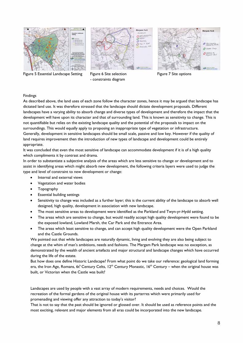
Figure 5 Essential Landscape Setting Figure 6 Site selection Figure 7 Site options - constraints diagram Findings As described above, the land uses of each zone follow the character zones, hence it may be argued that landscape has dictated land use. It was therefore stressed that the landscape should dictate development proposals. Different landscapes have a varying ability to absorb change and diverse types of development and therefore the impact that the development will have upon its character and that of surrounding land. This is known as sensitivity to change. This is not quantifiable but relies on the existing landscape quality and the potential of the proposals to impact on the surroundings. This would equally apply to proposing an inappropriate type of vegetation or infrastructure. Generally, development in sensitive landscapes should be small scale, passive and low key. However if the quality of land requires improvement then the introduction of new types of landscape and development could be entirely appropriate. It was concluded that even the most sensitive of landscape can accommodate development if it is of a high quality which compliments it by contrast and drama. In order to substantiate a subjective analysis of the areas which are less sensitive to change or development and to assist in identifying areas which might absorb new development, the following criteria layers were used to judge the type and level of constraint to new development or change:
Internal and external views Vegetation and water bodies Topography Essential building settings Sensitivity to change was included as a further layer; this is the current ability of the landscape to absorb well
designed, high quality, development in association with new landscape. The most sensitive areas to development were identified as the Parkland and Twyn-yr-Hydd setting. The areas which are sensitive to change, but would readily accept high quality development were found to be
the exposed lowland, Lowland Marsh, the Car Park and the Entrance Area. The areas which least sensitive to change, and can accept high quality development were the Open Parkland
and the Castle Grounds. We pointed out that while landscapes are naturally dynamic, living and evolving they are also being subject to change at the whim of man’s ambitions, needs and fashions. The Margam Park landscape was no exception, as demonstrated by the wealth of ancient artefacts and major structural and landscape changes which have occurred
Castle was b
h ts, needs whic
promenading and viewing offer any attraction to today’s visitor? That is not to say that the past should be ignored or glossed over. It should be used as reference points and the most exciting, relevant and major elements from all eras could be incorporated into the new landscape.
during the life of the estate. But how does one define Historic Laera, the Iron Age, Romans, 6th
built, or Victorian when the Landscapes are used by people witrecreation of the formal
ndscape? From what point do we taCentury Celts, 12th Century Monastic, 16th
uilt?
a vast array of modern requiremen gardens of the original house with its parterre
ke our reference: geological land forming Century – when the original house was
s and choices. Would the h were primarily used for

9
Visual Impact Given the landform and topography of the park there are no direct views into the site from the important conservation area of the castle and adjacent parkland. There are distant views into the site from the top of the ridgeline above Craig Lodge and Mynydd Castell and these are against the backdrop of the industrial landscape on the coastal belt and the pumping station built some twelve years ago. Important local views from the south-east of the site will be taken into consideration in the design process. Trees adjacent to the A48, Furzemill Pond and the belt stretching to Twyn Yr Hydd form an important buffer, limiting local views into the site. Recent tree planting in close proximity to the site will further limit views into the site from the north west once established. Archaeological, Ecological and Arboricultural Study Assessment of the impacts of the works upon the site, and features within and adjoining the site boundaries and wider area was undertaken. Apart from the park boundary wall, which is listed, most of the features identified are considered to be relatively minor or linear features and adequate mitigation in the form of a rapid survey and record prior to the works and a watching brief with contingencies for unexpected discovery during ground disturbing operations (ie. topsoil removal, foundation excavation, service trenching and base excavation) should suffice. The site was surveyed both topographically and historically and the proposed design is a response to the spatial, topographical and historic context. (Fig 9)
Fig 9 Site plan in context

10
Spatial aspects The Park has a number of physical advantages and a number of constraints. The Park is located to the south-east of Port Talbot and just off junction 38 on the M4. The site is just to the north of the A48 which bounds the south western side of the park. It sits just off the southern end of the park railway which will give visitors easy access to the site. It is envisaged that day visitors to the park and residential visitors would arrive at the northern end of the site via the park railway and that residential visitors coming by car would arrive from the south west using the access road from the A48 events entrance. (Fig 10) This is an existing route and the use of this again would reduce the impact of development on the existing landscape and at the same time enable access and routes to and from the new development to be intuitively understood rather than sign-posted. Aspects and prospects The site possesses prospects to the south west towards the coast, the steel works and the new biomass power station and particularly arresting views to the north to the castle and the rest of the park. (Fig 11)
Fig 10 Access Fig 11 Views on and off

11
There are a number of possible access points but the most striking is from the south through the east gate and across the parklands. This would provide the visitor with a directional view framing the castle and iron-age hill fort. (Fig 12)
Figure 12 View from south adjacent east gate The Panorama of the landscape from Mynydd Mawr was also critically important. This reveals the landscape of the Park on the coastal plain below. From here the formal terraced gardens rising from the Orangery to castle are clearly visible as well as the grounds and ornamental lakes laid out to the south contained by estate walls on the narrow coastal plain.

12
Lowest Clump is visible from Caer Cwm Phillip but the existing tree canopy masks the ground and the clumsy form and scale of the relatively recent pumping station beyond. (Fig 13)
Figure 13 View from Caer Cwm Phillip
Early modeled visual impact studies
Early visual impact studies

13
Spatial and Formal studies A number of options were explored with the main aim of combining architecture and landscape. The spatial and formal layout was organised to be an intrinsic part of the existing landscape. (Fig 14)
Fig 14 Design concepts There are four main elements: spatial grid, portals, courtyards and narrow ‘finger’ pavilions. These are combined to ensure the following:- The spatial grid This has been set up based loosely on tree spacing to enable a loose framework of siting buildings within the trees so that the existing trees are protected and enhanced and to provide a framework for new planting. The intention is that the buildings are in amongst the trees – almost like tree houses on piloti and that they would have open walkways to enable a ‘promenade architecurale’ (Fig 15)
Figure 15 The grid and the canopy
North - south orientation for framingviews and climate control
Integration with landscape

14
Portals Three goal post structures running east-west, set up by the existing landscape frame views north and south. (Fig 16)
Figure 16 Portals Courtyards The echelon form of the portals makes 3 connecting courtyards; one for arrival at the north, one ‘interlinked’ gathering space, and a third ‘open’ court maintaining views to the west. (Fig 17)
Figure 17 Interlinking courtyards Pavilions These are narrow width ‘finger’ buildings on a north-south axis to reduce the visual impact of buildings for the more critical directions. The buildings are modular timber ‘boxes’ on piloti and they lie on a north south axis. (Fig 18)

15
Figure 18 Timber pavilions
Site model of concept, form and visual
impact

16
Entrance perspective
Sectional perspective looking south from portal

17
Impacts of the chosen development upon the site and wider context and wider landscape. Visual impact The buildings have been designed as low profile ‘groundscrapers’ and to sit within the tree canopy. The buildings are not visible from the Castle and the buildings have been placed to enable views through the scheme from the North and the South approaches. This has been achieved by designing the residential and educational wings as narrow finger blocks running North-South. (Fig 19)
The views from the South to the Castle are uninterrupted by the buildings setting in Lowest Clump and three open gateway structures running East-West in echelon frame views into and out of the scheme. The East elevation running parallel to the access road is designed to read as a timber palisade enclosure. (Fig 20)
Figure 20 Early East elevation alongside entrance track From nowhere in the vicinity does the proposed scheme interrupt views to the Castle or those significant landscape elements of the landscape described as Mynydd Margam in the register of landscapes of historic interest. (Fig 21)
Figure 21 The building would be obscured by the tree canopy
Figure 19 Early Sectional Elevation looking North

18
Furthermore, the view from Caer Cwm Philip onto the park is unspoilt as the roofscape of the proposed development is under the canopy of existing trees and below the skyline in Lowest Clump. In conclusion views to and from elements of the historic landscape are not blocked or disrupted and we would argue that the siting and placement of architecture in this part of the site enhances visual connection between Park, Castle and Hill. Integration of buildings and landscape – the design process The separation of the disciplines of architectural design and landscape in recent times has been most damaging to the designed quality of both. The proposal for the Environmental Discovery Centre at Margam presents an opportunity to exploit the full scope and complexity of the relationships of historic landscape to contemporary architecture. This approach demands attention to the spatial, material and temporal aspects of both landscape and architecture. It should be acknowledged that landscape and architecture can be a way of constructing culture, or giving the patterns of our lives durable dimensions and patterns. The historic landscape at Margam results from man acting on the landscape architectonically to meet current needs. The approach to the design of the proposed Environmental Discovery Centre at Margam has been to enhance the existing landscape through design not to merely mitigate the effects of an anonymous new building. The aim is to avoid the production of an ‘object-building’ that is free from its context but rather ‘place’ a building in a context that would endow both with meaning. The building and landscape have been considered together in the tradition of the place. Site description The site for the proposed environmental discovery centre is among a grove of trees lying near the park boundary towards the southern end of the parklands – known as Lowest Clump. To the north east is an avenue which connects the castle to the eastern gate of the park, and the mini-railway for visitors runs just north of the site. The site slopes gently down to the west towards the park boundary. There are two areas of water on the site; there is a pond running north-south across the site, and a stream running along the north western edge.
The trees on the site are primarily a mix of mature deciduous trees, with some evergreen species to the west of the site. Some of the trees around the pond in the centre of the site seem to be in a bad state and may need to be removed as identified in the Arboricultural report (appendix 6). There is one building on the site, a small block-work and timber barn with a mono-pitch roof, located to the north of the pond. Off the site to the west is a stone built pumping station accessed from the main road.

19
Elevation looking east
Sectional elevation through the portals looking south Objective 2 Environment and sustainability Physical and topographical impact The scheme was deliberately designed to ‘touch the earth lightly’. This means that as far as possible the buildings are not lying on heavy foundations and slabs that bear directly on the ground. Rather, wherever possible, they are place on piloti according to grid. This means that apart from the residential wing that is set down on the ground to reduce visual impact, the scheme is on driven piled foundations using recycled oil pipe which are minimal due to the low heights of the building. The ground would suffer only minimal disturbance and the intention was to return the area around the pond to its current condition as this forms the ‘ecological’ focal point. The Canada Geese occupying the pond at the heart of the scheme stayed throughout construction and the pond remains home. Design with Climate We consider making maximum use of macro and micro climatic conditions as the foundation of sustainable design. The outer envelope has been designed as a climatic filter of the climate that varies at different times of the year to control the micro-climate within the internal spaces. The building was to be: 100% Daylit using northlighting to educational spaces and sidelit to all others to promote views; naturally ventilated; It would employ: a passive solar strategy to all spaces; · sheltered circulation spaces and courtyards to provide and provides: a healthy and safe environment; · allergen-free interiors; · visitor contact with the landscape and environment; and: exploit renewable energy sources; · promote 'natural' ecology;
Typical summer’s day

20
Typical winter’s day
In order to minimize embodied energy and waste , the timber framed building has been largely constructed off site, using timber from local sources, with pre-fabricated modules being assembled on site. To minimise heat losses and the need for mechanical services, the building has been insulated to standards well in excess of Building Regulations requirements. Space heating is provided by an underfloor heating system to provide for maximum user comfort and is served by a wood pellet biomass boiler. Wood pellets for the biomass boiler are stored in a high capacity external silo to minimise frequency of deliveries and thus further reduces the carbon footprint and also contributes to the rural character of the building an the entrance court. As biomass is considered to be a carbon-neutral fuel, the use of a biomass boiler has been predicted to reduce CO2 emissions by 40%, giving the centre a predicted carbon footprint of less than 10 kg.CO2/m2 per annum. Supplementing the biomass boiler in winter a gas fired condensing boiler has been installed, this uses the low return water temperatures from the underfloor heating to maximise condensing. Hot water in the teaching block is provided by solar thermal panels, supplemented by the boiler plant when necessary. The centre is designed to be mainly naturally ventilated via a combination of opening windows and automatic roof lights, the latter being controlled via rain and temperature sensors to prevent overheating in summer and ensure occupant comfort. Rainwater is stored in a below ground water tank and used for flushing WCs and urinals within the public toilets. Mains cold water is used a secondary source of supply to the tank to ensure minimum water levels are maintained. The north-facing roof lights also help to optimize daylight while minimising solar heat gains. Whilst the building is designed to be entirely daylit this is supplemented by predominantly fluorescent artificial lighting, using a combination of high frequency T5 sources in teaching areas and compact fluorescent in accommodation areas. All services are controlled through a building management system (BMS), with extensive monitoring of energy consumption to ensure that systems are operating at maximum efficiency.
Ventilation and daylight strategy

21
Objective 3 Tectonic form In order to qualify for the European Funding Element of the budget the scheme had to be designed and ‘substantially completed’ within 18 months. Due to the sensitive nature of site it was considered critical to be able to build quickly. The Discovery Centre is positioned on site and a 7.2m x 8.4m spatial and structural grid located as to fit around the pond was aligned with the row of trees to the south-west and on a north - south axis to provide a spatial and constructional framework. The building was originally split into 2 structural forms of MMC to accelerate construction time: Panel or volumetric structure - residential wing The bedroom modules are the smallest modules in the building at 3.6m x 6m each including an attached 2.4m wide circulation spine. This repetitive nature and small scale of the units with the need for good acoustic and thermal performance lends itself well to an advanced timber panel form of construction. These panels or modules were to be factory prepared to include structure, insulation, cladding services and hoisted into position on site rapidly forming a weathertight shell within which only decoration and connection to services would be needed. Post and beam structure - large span elements to educational wings All other elements of the building can be considered as medium span, across the 7.2m grid. As these elements of the centre would either consist of large spaces for dining and kitchen or require large amounts of glazing or open facades for views, ventilation and natural lighting was initially thought appropriate to use a timber post and beam system. The original images below show a traditional, but standardised and repetitive building system - the Segal method. Each timber element is a standard length and section connected together simply, quickly and easily on- site. These early dimensional and tectonic concepts survived and proved to be robust. Ultimately a larger proportion of the scheme was constructed off-site through the use of timber engineering techniques and modular construction.

22
Construction process from factory to site

23
Materiality and appearance Again the predominant idea in terms of the materiality and appearance (as well as sustainability) of the scheme is the integration with the landscape and the existing trees in particular. The plan to use local materials – predominantly timber running North South and metal for the East-West ‘portals’. The buildings are timber structures clad in locally grown Sweet Chestnut. to be untreated and will weather to a silver grey patina. Cladding will consist of vertical or horizontal strips of timber as open rainscreen. The education wings have open walkways which further layer and therefore diminish the overall impact of building mass. Roof claddings are a combination of flat roofs on the accommodation block and pre-patinated copper roofs elsewhere to again limit the visual impact of the scheme visually from the uplands of the Park. (Fig 22)
Figure 22 Original palette of materials – weathered hardwood cladding, open walkways, sedum and metal roofs - designed to blend into landscape
Finished building showing predominant materials – Sweet Chesnut Cladding, Pre-patinated copped

24
Critical Summary Site and landscape ‘There is no such thing as a Welsh Architecture’ Jan Morris wrote but conceded that if there was one distinctive hallmark of the building art of Wales it exists in the conciliatory power, the ability to unite a structure with its setting, and make it feel part of nature. This coupling of landform and building form was achieved intuitively in much of the vernacular building of Wales. Our approach to site (landscape) is relatively consistent regardless of location or size. We combine some native intuition with a lot of time and effort mapping, drawing, modelling referencing and researching – not always knowing where this will lead or what will come of it. At Margam, the landscape is listed in the Register for Historic Landscapes in Wales. Places need to be altered to sustain them and Margam’s landscape had been ‘managed’ for over 3000 years. In ‘Topographical Stories’ David Leatherbarrow refers to the possibility of the building as an elaboration of the terrain and which ‘is not substantial in its own terms, nor self sufficient, but dependent, or adjective to its milieu’. We pursued an adjectival architecture, where an analysis of site may ‘structure’ the project. Under this dispensation, site – or more broadly ambient landscape – is not what surrounds and supplements the building, but what enters into, continues through, emanates from and enlivens it. That is about as close as we can explain what we tried to do at Margam – frame, hold, ensure spatial continuity, nestle, sense climate, feel nature... In the tense days of trying to win over the conservationists a Robert Smithson quote - 'the gardens of history are being replaced by the sites of time‘ became important along with the image of his Partially buried Woodshed. When there is no Eco left to discover the site will become something else. Sustainability In the ‘Environmental Tradition’ Dean Hawkes traces the history of those architects for whom environmental delight is at the core of the architectural idea. Having trained at the WSA in the Parry, Jones, Hawkes era, it is in our nature to consider the form of the climatically responsive building envelope. We don’t use too many numbers or a computer model in this endeavour. Heuristics based on drawn studies and rules of thumb prevail – especially the sectional development- is the sky visible to the occupier, what is the distance from the window wall? Further investigation is conducted with physical models in our Sky. Resulting building form tends to be narrow and spindly, single sided circulation spaces or in a most recent scheme ‘punctured’ plans prevail – all of which are hard to justify to cost consultants and happen before we get to the BREEAM shopping list. We wonder do we over-glaze, about the potential of the shadow more than whether we can get a point for daylight. The building emission rate at Margam was predicted as 9.5kg/m2 per annum. We are in pursuit of environmental delight and user control. We have tried Passivhaus but remain cautious. At Margam we deliberately created a ‘promenade architecturale’ which was right at the boundary of outside and inside – where life is lived although we are for the hearth as well. Tectonic Form This is, perhaps, most difficult to reconcile. How to build? Michael Sorkin says ‘Joinery is always the moment of truth for architecture of gravity’ . We say chance would be a fine thing! We have had to create our own opportunities to craft (in A Richard Sennett sense) small buildings. Under the command and control systems of constructing excellence, procurement systems, partnering, certification and compliance is there a chance for authenticity and tactility let alone substance? We have become more knowledgeable about building systems rather than detailing because we needed to be. 70% of Margam was pre-fabricated in a former aircraft hangar near Hull. We were able to insist on timber technologies but whilst our initial intention had been to employ locally sourced material (within a 50 mile radius), only the hardwoods were sourced from British forests. Perhaps in the future re-engineered, renewable local materials will be incorporated into local/regional components and systems in resistance to the homogenising and flattening effect of globalised construction. This is as an area in which we continue to work with manufacturers and suppliers – big and small.

25
1.9 Record of artefact
The finished building

26

27
1.10 Impact Significant Appendices Appendix I
Forster, Wayne, and others, ‘A two-way conversation’ Touchstone Issue 18 pp.2-8 Appendix II Chapman, Tony, ‘Architecture 10. RIBA Buildings of the Year’ Merrell 2010 ISBN 978-1-8589-4539-2 Birch, Amanda 'Five Stars in the making: YAYA shortlist 2010,' Building Design 8 October 2010
Lea, David, ‘A two-way conversation’ Touchstone Issue 18 pp.2-8 Design Commission for Wales Case Study: Environmental Margam Discovery Centre http://dcfw.org/casestudies/view/margam_discovery_centre/ Young ,Eleanor, 'Greening the Valleys', RIBA Journal February 2011