douglas county division of open space and natural

1
! A ! ! !! ! ! ! ! ! ! A ! A ! ! Perry Park Road / 105 Spruce Mountain Road / 53 Noe Road S p r u c e M o u nta i n T rail E a gl e P a s s T r a i l S p r u ce M e a d o w s T rai l E a gl e P a s s T r a il S h o r tc u t Sp r u ce M e a d o w s T r a i l U p p e r Lo o p S e r v ic e R o ad S e r v i ce Ro a d - C l o s e d . 5 .3 . 6 .3 . 3 . 1 1. 0 1 . 9 1 . 1 . 7 1 . 6 . 5 .4 . 1 Eagle Mountain 7515 ft. Eagle Pass East Pine Jct. Upper Loop Jct. Service Road Jct. Windy Point 7605 ft. Greenland Overlook Trailhead Oak Shortcut Oak Shortcut 7500 7400 7300 7200 7100 7200 7100 7000 7100 7200 7300 7400 Private Property Spruce Mountain Douglas County Open Space -Public- Eagle Mountain Conservation Easement -Private- Locked Gate " i ! TH " i # D Larkspur 5 miles Palmer Lake 2 miles Private Property No Trailer Parking " i Trailer Parking Spruce Mountain Road / 53 Spruce Mountain Open Space Trail ! ! ! ! A ! ! ! A ! 7500 feet 7300 feet 7100 feet Spruce Mountain Trail - Profile Upper Loop Jct. 3.9 miles Service Road Jct. 2.4 miles Upper Loop Jct. 1.7 miles Pine Jct. 0.7 miles Eagle Pass East 0.4 miles Trialhead 0.1 miles Windy Point 2.7 miles Greenland Overlook 1.3 miles General Information 0.3 0 0.3 Miles Spruce Mountain Trailhead: I-25 S to Larkspur Exit. Go south on Spruce Mountain Road 6 miles (one mile past the intersection with Noe Road). Trailhead for cars is on right. Spruce Meadows Trailhead: Horse trailers park here. I-25 to Greenland Exit 67. West ¼ mile on Greenland Road, curve south ½ mile, and west over RR tracks ¼ mile. Spruce Meadows trailhead is on your left. Cars can continue west on Noe Road for 1.5 miles to Spruce Mtn. Rd. Go left 1 mile to Spruce Mtn. Trailhead on right. Directions Two-Track Trails Roads 100 Foot Contours ! Sign Posts ! A Points Of Interest Private Property Spruce Mtn. Bndy. The 5.5-mile Spruce Mountain Trail gently switchbacks up to fabulous rocky overlooks and a loop around the mountaintop through pines and firs. Descend the Service Road to catch the scenic Eagle Pass Trail, returning you to the trailhead via meadows and trees with great views of Eagle Mountain. ¯ Douglas County Division of Open Space and Natural Resources 100 Third Street, Castle Rock, CO 80104 (303-660-7492) www.douglas.co.us/openspace F Ë Í : G K # D Í # D Hikers Horses Dogs on Leash Mountain Bikers No Motorized Vehicles No Unleashed Pets Trail Uses Trail Closures Area of Interest § ¨ ¦ 25 £ ¤ 85

Upload: others

Post on 20-Dec-2021

1 views

Category:

Documents


0 download

TRANSCRIPT

!A

!!

! !

!

!

!

!

!

!A

!A

!

!

Perry

Par

k Roa

d / 10

5

Spruc

e Mou

ntain

Road /

53

Noe Road

Spruc

e Mou

ntain Trail

Eagle Pass Trai

l

Spruce Meadows Trail

Eagle

Pass Tra

il Shortcut

Spruce Mea

dows

Tra il

Upp er LoopService Road

Se rvice Road - Closed

.5

.3

.6

.3 .3.1

1.0

1.9

1.1

.7

1.6

.5

.4

.1

EagleMountain7515 ft.

Eagle PassEast

PineJct.

UpperLoopJct.

ServiceRoadJct.

WindyPoint

7605 ft.

GreenlandOverlook

Trailhead

OakShortcutOakShortcut

75007400

7300

7200

7100

7200

7100

7000

7100

7200

7300 7400Private

Property

Spruce MountainDouglas County

Open Space-Public-

Eagle MountainConservation Easement

-Private-

LockedGate

"i!TH

"i#D

Larkspur5 miles

Palmer Lake2 miles

PrivateProperty

NoTrailerParking

"iTrailerParking

Spruc

e Mou

ntain

Road

/ 53

Spruce Mountain Open Space Trail

!!

!

!A!

!

!A

!7500 feet

7300 feet

7100 feet

Spruce Mountain Trail - Profile

UpperLoop Jct.3.9 miles

ServiceRoad Jct.2.4 miles

Upper Loop Jct.1.7 miles

Pine Jct.0.7 miles

EaglePass East0.4 miles

Trialhead0.1 miles

Windy Point2.7 miles

GreenlandOverlook1.3 miles
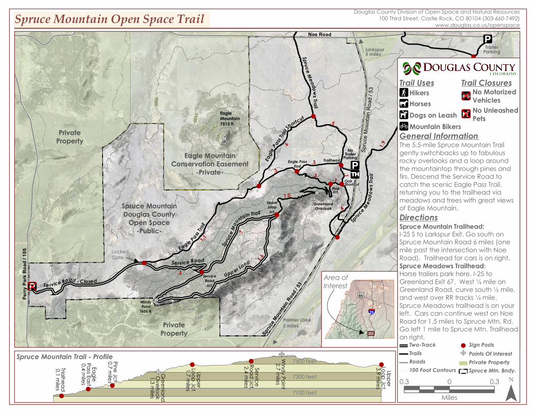
General Information

0.3 0 0.3Miles

Spruce Mountain Trailhead:I-25 S to Larkspur Exit. Go south onSpruce Mountain Road 6 miles (onemile past the intersection with NoeRoad). Trailhead for cars is on right.Spruce Meadows Trailhead:Horse trailers park here. I-25 toGreenland Exit 67. West ¼ mile onGreenland Road, curve south ½ mile,and west over RR tracks ¼ mile.Spruce Meadows trailhead is on yourleft. Cars can continue west on NoeRoad for 1.5 miles to Spruce Mtn. Rd.Go left 1 mile to Spruce Mtn. Trailheadon right.

Directions

Two-TrackTrailsRoads100 Foot Contours

! Sign Posts!A Points Of Interest

Private PropertySpruce Mtn. Bndy.

The 5.5-mile Spruce Mountain Trailgently switchbacks up to fabulousrocky overlooks and a loop aroundthe mountaintop through pines andfirs. Descend the Service Road tocatch the scenic Eagle Pass Trail,returning you to the trailhead viameadows and trees with great viewsof Eagle Mountain.

¯

Douglas County Division of Open Space and Natural Resources100 Third Street, Castle Rock, CO 80104 (303-660-7492)

www.douglas.co.us/openspace

F

Ë

Í

:G

K#D

Í#D

HikersHorsesDogs on LeashMountain Bikers

No MotorizedVehiclesNo UnleashedPets

Trail Uses Trail Closures

Area ofInterest

§̈¦25

£¤85