dot hs 811 631 june 2012 mmucc guideline
TRANSCRIPT
DOT HS 811 631June 2012
8718-061412-v2
MMUCC GuidelineModel Minimum Uniform Crash Criteria
Fourth Edition (2012)

i
MMUCC Guideline Contents
Executive Summary ...................................................................................................................................... vi
Introduction ............................................................................................................................................... viii
MMUCC Data Elements ................................................................................................................................ 1
Data Elements Collected at Scene ............................................................................................................ 1
Crash Data Elements ................................................................................................................................. 1
C1. Case Identifier ................................................................................................................................ 1
C2. Crash Classification ......................................................................................................................... 2
C3. Crash Date and Time ...................................................................................................................... 3
C4. Crash County .................................................................................................................................. 3
C5. Crash City/Place (political jurisdiction) .......................................................................................... 4
C6. Crash Location ................................................................................................................................ 4
C7. First Harmful Event......................................................................................................................... 5
C8. Location of First Harmful Event Relative to the Trafficway ........................................................... 6
C9. Manner of Crash/Collision Impact ................................................................................................. 7
C10. Source of Information .................................................................................................................. 7
C11. Weather Conditions ..................................................................................................................... 7
C12. Light Condition ............................................................................................................................. 8
C13. Roadway Surface Condition ......................................................................................................... 9
C14. Contributing Circumstances, Environment .................................................................................. 9
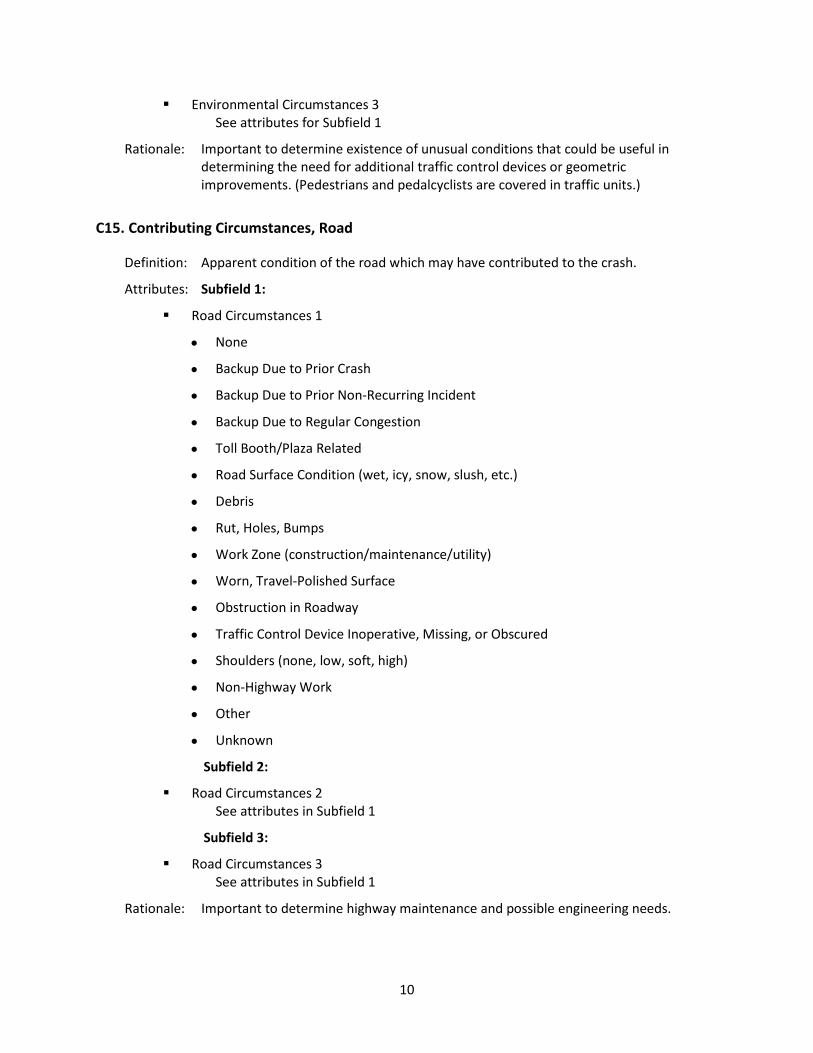
C15. Contributing Circumstances, Road ............................................................................................. 10
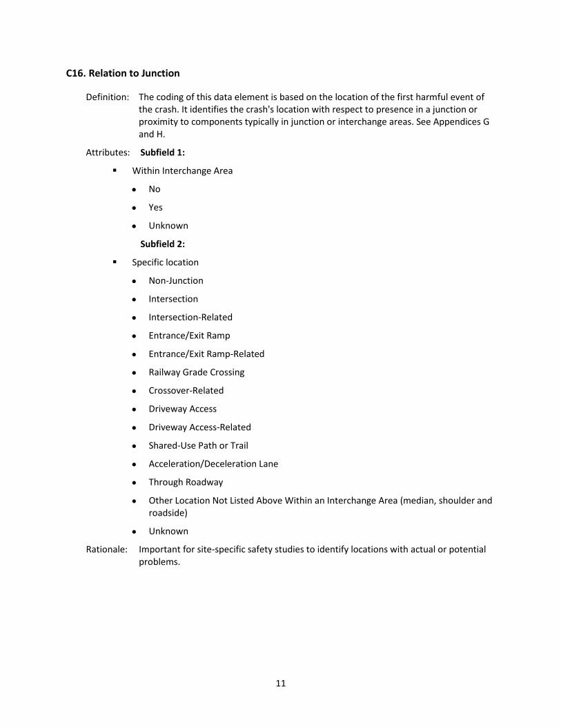
C16. Relation to Junction ................................................................................................................... 11
C17. Type of Intersection ................................................................................................................... 12
C18. School Bus-Related ..................................................................................................................... 12
C19. Work Zone-Related (Construction/Maintenance/Utility) .......................................................... 12
Vehicle Data Elements ............................................................................................................................ 14
V1. Motor Vehicle Identification Number (VIN) ................................................................................. 14
V2. Motor Vehicle Unit Type and Number ......................................................................................... 14
V3. Motor Vehicle Registration State and Year .................................................................................. 14
V4. Motor Vehicle License Plate Number .......................................................................................... 15
ii
V5. Motor Vehicle Make .................................................................................................................... 15
V6. Motor Vehicle Model Year ........................................................................................................... 15
V7. Motor Vehicle Model ................................................................................................................... 16
V8. Motor Vehicle Body Type Category ............................................................................................. 16
V9. Total Occupants in Motor Vehicle ............................................................................................... 17
V10. Special Function of Motor Vehicle in Transport ........................................................................ 17
V11. Emergency Motor Vehicle Use ................................................................................................... 18
V12. Motor Vehicle Posted/Statutory Speed Limit ............................................................................ 18
V13. Direction of Travel Before Crash ................................................................................................ 18
V14. Trafficway Description ............................................................................................................... 19
V15. Total Lanes in Roadway .............................................................................................................. 19
V16. Roadway Alignment and Grade ................................................................................................. 20
V17. Traffic Control Device Type ........................................................................................................ 20
V18. Motor Vehicle Maneuver/Action ............................................................................................... 21
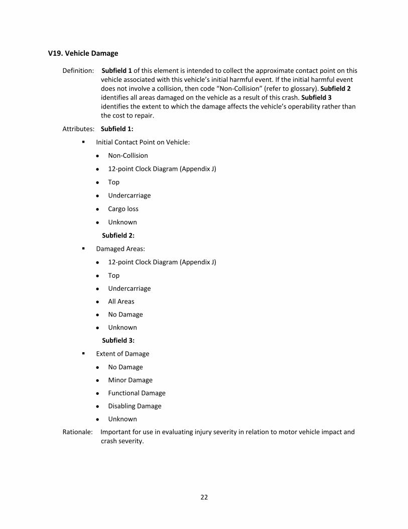
V19. Vehicle Damage ......................................................................................................................... 22
V20. Sequence of Events .................................................................................................................... 23
V21. Most Harmful Event for this Motor Vehicle ............................................................................... 25
V22. Bus Use ....................................................................................................................................... 26
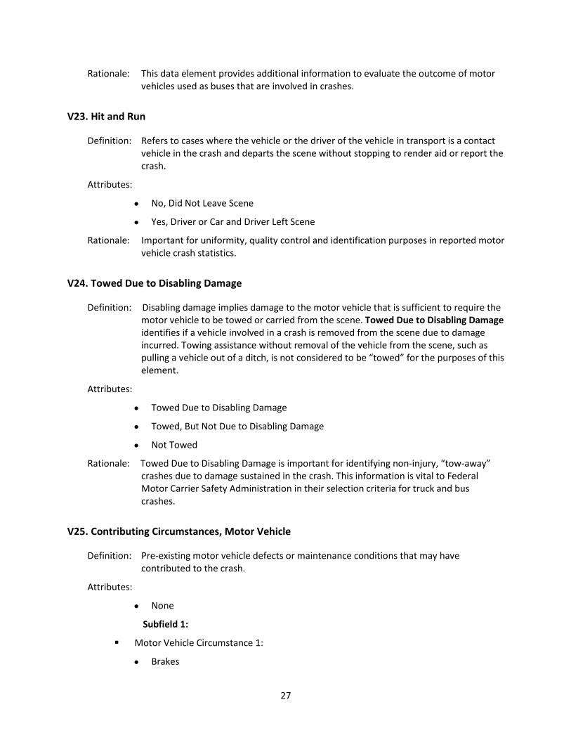
V23. Hit and Run ................................................................................................................................. 27
V24. Towed Due to Disabling Damage ............................................................................................... 27
V25. Contributing Circumstances, Motor Vehicle .............................................................................. 27
V26. Motor Carrier Identification** ................................................................................................... 28
V27. Gross Vehicle Weight Rating / Gross Combination Weight Rating** ........................................ 29
V28. Vehicle Configuration** ............................................................................................................. 30
V29. Cargo Body Type** .................................................................................................................... 30
V30. Hazardous Materials (Cargo Only)** ......................................................................................... 31
Person Data Elements ............................................................................................................................ 32
Level 1: All Persons Involved .................................................................................................................. 32
P1. Name of Person Involved ............................................................................................................. 32
P2. Date of Birth ................................................................................................................................. 32
P3. Sex ................................................................................................................................................ 33

iii
P4. Person Type .................................................................................................................................. 33
P5. Injury Status ................................................................................................................................. 34
Level 2: All Occupants ............................................................................................................................. 35
P6. Occupant’s Motor Vehicle Unit Number ...................................................................................... 35
P7. Seating Position ............................................................................................................................ 35
P8. Restraint Systems / Motorcycle Helmet Use ............................................................................... 36
P9. Air Bag Deployed .......................................................................................................................... 37
P10. Ejection ....................................................................................................................................... 37
Level 3: All Drivers .................................................................................................................................. 38
P11. Driver License Jurisdiction .......................................................................................................... 38
P12. Driver License Number, Class, CDL and Endorsements** ......................................................... 38
P13. Speeding Related ........................................................................................................................ 40
P14. Driver Actions at Time of Crash .................................................................................................. 40
P15. Violation Codes .......................................................................................................................... 41
P16. Driver Distracted By ................................................................................................................... 41
Level 4: All Drivers and Non-motorists ................................................................................................... 42
P17. Condition at Time of the Crash .................................................................................................. 42
P18. Law Enforcement Suspects Alcohol Use .................................................................................... 43
P19. Alcohol Test ................................................................................................................................ 43
P20. Law Enforcement Suspects Drug Use ......................................................................................... 44
P21. Drug Test .................................................................................................................................... 44
Level 5: Non-Motorists (includes occupants of motor vehicles not in transport and occupants of non-motor vehicle transportation devices) ............................................................................................ 45
P22. Non-Motorist Number ............................................................................................................... 45
P23. Non-Motorist Action/Circumstance Prior to Crash .................................................................... 45
P24. Non-Motorist Actions/Circumstances at Time of Crash ............................................................ 46
P25. Non-Motorist Location at Time of Crash .................................................................................... 47
P26. Non-Motorist Safety Equipment ................................................................................................ 47
P27. Unit Number of Motor Vehicle Striking Non-Motorist .............................................................. 48
Level 6: All Injured .................................................................................................................................. 48
P28. Transported to First Medical Facility By ..................................................................................... 48

iv
Derived and Linked Data Elements ......................................................................................................... 49
Crash Data Elements Derived From Collected Data ............................................................................... 49
CD1. Crash Severity ............................................................................................................................ 49
CD2. Number of Motor Vehicles Involved ......................................................................................... 50
CD3. Number of Motorists ................................................................................................................. 50
CD4. Number of Non-Motorists ......................................................................................................... 50
CD5. Number of Non-Fatally Injured Persons .................................................................................... 51
CD6. Number of Fatalities .................................................................................................................. 51
CD7. Alcohol Involvement .................................................................................................................. 51
CD8. Drug Involvement ...................................................................................................................... 52
CD9. Day of Week ............................................................................................................................... 52
Person Data Elements Derived From Collected Data ............................................................................. 52
PD1. Age ............................................................................................................................................. 52
Person Data Elements Obtained After Linkage to Other Data ............................................................... 53
Level 3: All Drivers .................................................................................................................................. 53
PL1. Driver License Restrictions ......................................................................................................... 53
PL2. Driver License Status .................................................................................................................. 54
PL3. Drug Test Result .......................................................................................................................... 55
Level 6: All Injured Persons ..................................................................................................................... 55
PL4. Injury Area .................................................................................................................................. 55
PL5. Injury Diagnosis .......................................................................................................................... 56
PL6. Injury Severity ............................................................................................................................. 56
Roadway Data Elements Obtained After Linkage to Other Data ........................................................... 57
RL1. Bridge/Structure Identification Number .................................................................................... 57
RL2. Roadway Curvature .................................................................................................................... 58
RL3. Grade .......................................................................................................................................... 58
RL4. Part of National Highway System ............................................................................................... 59
RL5. Roadway Functional Class .......................................................................................................... 59
RL6. Annual Average Daily Traffic ...................................................................................................... 60
RL7. Widths of Lane(s) and Shoulder(s) ............................................................................................. 60
RL8. Width of Median ........................................................................................................................ 60
v
RL9. Access Control ............................................................................................................................ 61
RL10. Railway Crossing ID ................................................................................................................... 61
RL11. Roadway Lighting ..................................................................................................................... 62
RL12. Pavement Markings, Longitudinal ............................................................................................ 62
RL13. Presence/Type of Bicycle Facility ............................................................................................. 63
RL14. Traffic Control Type at Intersection ......................................................................................... 63
RL15. Mainline Number of Lanes at Intersection ............................................................................... 64
RL16. Cross-Street Number of Lanes at Intersection ......................................................................... 64
RL17. Total Volume of Entering Vehicles ........................................................................................... 65
Glossary ....................................................................................................................................................... 66
Acronyms ................................................................................................................................................ 66
MMUCC Data Element Attribute Terminology ....................................................................................... 67
Appendix A: MMUCC 2011-2012 Expert Panel Members Contact list ....................................................... 98
Appendix B: Summary of Changes to the MMUCC Guideline, 3rd Edition (2008) .................................... 102
Appendix C: Date and Time Formats ........................................................................................................ 112
Appendix D: State, Province and FIPS Codes ............................................................................................ 113
Appendix E: Diagram of the Trafficway .................................................................................................... 115
Appendix F: Manner of Collision ............................................................................................................... 116
Appendix G: Diagram of an Interchange ................................................................................................... 119
Appendix H: Diagram of an Intersection ................................................................................................... 120
Appendix I: Diagrams of a Work Zone Area and Toll Booth/Plaza Area ................................................... 121
Appendix J: Clockpoint Diagrams for Different Types of Motor Vehicles ................................................. 123
Appendix K: Definitions for Truck Configurations and Placards ............................................................... 124
Appendix L: Sequence of Events Examples ............................................................................................... 128
Appendix M: Air Bags Diagram ................................................................................................................. 131
Appendix N: Seating Position .................................................................................................................... 132

vi
Executive Summary The purpose of the Model Minimum Uniform Crash Criteria (MMUCC) is to provide a dataset for describing crashes of motor vehicles in transport that will generate the information necessary to improve highway safety within each State and nationally. Statewide motor vehicle traffic crash data systems provide the basic information necessary for effective highway and traffic safety efforts at any level of government – local, State, or Federal. State crash data are used to perform problem identification, establish goals and performance measures, allocate resources, determine the progress of specific programs, and support the development and evaluation of highway and vehicle safety countermeasures. Unfortunately, the use of State crash data is often hindered by the lack of uniformity between and within States. MMUCC represents a voluntary and collaborative effort to generate uniform crash data that are accurate, reliable and credible for data-driven highway safety decisions within a State, between States, and at the national level. MMUCC was originally developed in response to requests by States interested in improving and standardizing their State crash data. Lack of uniform reporting made the sharing and comparison of State crash data difficult. Different elements and definitions resulted in incomplete data and misleading results. MMUCC recommends voluntary implementation of a “minimum set” of standardized data elements to promote comparability of data within the highway safety community. It serves as a foundation for State crash data systems. Efforts to standardize crash data have increased since MMUCC was originally recommended as a voluntary guideline in 1998. More and more States included MMUCC in their data review process as they sought to revise their crash report forms. The American National Standards Institute (ANSI) Standard D16.1-2007 Manual on Classification of Motor Vehicle Traffic Accidents, Seventh Edition, and the ANSI Standard D20.1, Data Element Dictionary for Traffic Records Systems were both used to develop and update MMUCC. Under the Safe, Accountable, Flexible, Efficient Transportation Equity Act: A Legacy for Users (SAFETEA-LU) States have been able to receive funds for crash data system improvements. In order to receive these SAFETEA-LU Section 408 grants, a State must certify that it has adopted and uses model data elements identified by the Secretary of Transportation or that it will use Section 408 grant funds toward adopting and using the maximum number of such model data elements as soon as practicable. The MMUCC elements were identified by US DOT as one set of model data elements that apply to

vii
Section 408 (the other sets being the National Emergency Medical Services Information System [NEMSIS] for EMS data and the Model Inventory of Roadway Elements [MIRE] for roadway inventory data). In the next Congressional reauthorization, there is likely to be continued funding for data improvements, and States will be encouraged to use the funding for, among other things, adoption of MMUCC data elements to the extent practicable. Implementation of MMUCC is a collaborative effort involving the Governors Highway Safety Association (GHSA), the Federal Highway Administration (FHWA), the Federal Motor Carrier Safety Administration (FMCSA), and the National Highway Traffic Safety Administration (NHTSA). The review and update of the MMUCC Guideline, 3rd Edition (2008) was structured to obtain maximum input from all sectors of the highway safety community. Over a 12-month period during 2011-2012, feedback was obtained from meetings, via the Web, email, and phone, before producing the MMUCC Guideline, 4th Edition (2012). The MMUCC data elements represent a core set of data elements, most of which were being collected by the States before the first edition of the MMUCC Guideline was published. The 107 data elements contained in the MMUCC Guideline, 3rd Edition (2008) were revised in response to emerging issues and other highway safety needs. The fourth edition of the MMUCC Guideline contains 110 data elements. The MMUCC Guideline, 4th Edition (2012) recommends that States implement all 110 data elements included in this document. To reduce the data collection burden, MMUCC recommends that law enforcement at the scene should collect 77 of the 110 data elements. From crash scene information, 10 data elements can be derived, while the remaining 23 data elements should be obtained after linkage to other State data files. States that are unable to link to other State data to obtain the MMUCC linked data elements should collect, at a minimum, those linked data elements that are feasible to collect on the crash report. At the same time, States should work to develop data linkage capabilities so they eventually are able to obtain, via linkage, all of the information to be generated by the MMUCC linked data elements. Because State datasets and systems are difficult to implement or change, no changes will be made to the MMUCC Guideline, 4th Edition (2012) for five years. During this period, each of the data elements and their attributes will be monitored to determine their usefulness and reliability. The next planned update of the MMUCC Guideline is scheduled for 2017.

viii
Introduction
Motor vehicle crashes are the leading cause of death for people under 35 in the United States. More than 30,000 people are killed and approximately 2.5 million are injured on the Nation’s highways every year. Each of these events is described in a Police Accident Report (PAR) that law enforcement officials prepare daily. Motor vehicle crash reporting provides valuable data to many different groups: the traffic engineer planning to resurface a road; the city planner developing safe school routes; the high school driver education teacher planning a curriculum; the public works director applying for a State grant for reconstructing a hazardous intersection; the police sergeant targeting selective enforcement; the motor vehicle administrator; the highway safety planner; and countless others who need timely, complete, and accurate motor vehicle crash information. These stakeholders need high-quality data to develop policies and programs that will improve the safety and the operation of the Nation’s roadway transportation network. Improving motor vehicle traffic crash data will help State and local agencies identify specific traffic safety problems, communicate safety issues to the public and media, make better programming and resource allocation decisions and enable better monitoring and program evaluation. Ultimately, better data will lead to safer roadways. Although all States and localities collect crash data, there are many inconsistencies in the way they collect it. Data definitions vary, the number and type of data elements vary, and the threshold for collecting data varies from jurisdiction to jurisdiction. To bring greater uniformity to crash data collection and to provide national guidance to data collectors, the Model Minimum Uniform Crash Criteria (MMUCC) was first created in 1998 and then updated in 2003 and 2008. For all editions of MMUCC, an expert panel was formed to oversee the development and revision of the data elements. There were also ample opportunities for public comment both at meetings and online. For the Fourth Edition, an expert panel met twice and also communicated via e-mail. A one-day session at the 2011 Traffic Records Forum was held to solicit comments on proposed MMUCC data elements. Comments were also submitted on the MMUCC website, www.mmucc.us. (For a complete listing of the Fourth Edition MMUCC Expert Panel, see Appendix A.) What is MMUCC? MMUCC is a guideline that presents a model minimum set of uniform variables or data elements for describing a motor vehicle crash. The use of MMUCC data elements will generate data that can be employed to make more informed decisions which will lead to improvements in safety and at the national, State and local levels. States are encouraged to adopt as many recommended MMUCC data

ix
elements as possible when they next update their PARs. Data elements were developed and incorporated into MMUCC if they were deemed necessary (needed for highway safety decision-making purposes) and comprehensive (included all aspects of the issue or problem being described). The MMUCC Guideline is based on two other data standards, ANSI D16 (for classifying motor vehicle traffic crashes) and ANSI D20 (for promoting uniformity in the transmission of records between jurisdictions). MMUCC has also been developed in close association with the National Highway Traffic Safety Administration’s Fatality Analysis Reporting System (FARS) and National Automotive Sampling System (NASS), as well as the data elements mandated by the Federal Motor Carrier Safety Administration (FMCSA). The use of MMUCC is voluntary. However, any State wishing to apply for Section 408 State Traffic Information System Improvement Grants must certify that it has adopted and uses the Model Data Elements, or that Section 408 grant funds it receives will be used toward adopting and using the maximum number of such Model Data Elements as soon as practicable. Since MMUCC is a minimum data set, States and localities may choose to collect additional motor vehicle crash-related data elements if they feel the data are necessary to enhance decision-making. MMUCC does not present coding values for the data element attributes. States have the option of designing the content and format of their crash report as well as the most appropriate data collection system and data coding conventions to meet their needs. The MMUCC Guideline is updated every four or five years to address emerging highway safety issues, simplify the list of recommended data elements, and clarify data definitions and other components of each data element. The next update is anticipated to be in 2017. A summary of the changes in the 4th Edition to each data element is available in Appendix B. Organization of MMUCC Data Elements Each MMUCC data element includes a definition, a set of specific attributes and a rationale for why it is needed. Data elements are divided into four major groups that describe various aspects of a crash: crash, vehicle, person, and roadway. MMUCC consists of data elements that are recommended to be captured at the crash scene, together with linked and derived data. From the crash scene information, additional data elements can be derived, which lessens the burden on law enforcement. Additional data elements are recommended through linkage to driver history, hospital and other health/injury data, and roadway inventory data. Each group of data elements has a unique identifier that describes what type of data element it is as well as whether it is derived or linked. Some data elements are marked with a double asterisk (**) to

x
indicate that these elements are mandated by FMCSA for qualifying crashes involving vehicles greater than 10,000 lbs. (gross vehicle weight rating or gross combination weight rating), buses, and vehicles transporting hazardous materials. Reporting Threshold Recommended to Implement MMUCC In addition to specifying the minimum set of uniform data elements that should be collected for motor vehicle traffic crashes, the MMUCC Guideline also indicates for which motor vehicle crashes MMUCC data should be collected. The MMUCC Guideline does so by setting the threshold for reporting the most significant motor vehicle crashes. Without collection of data on the most important crashes, a State’s or locality’s data will paint an incomplete picture of the motor vehicle crash problem. Analysis of the data will be skewed as a result, and the jurisdiction may end up allocating resources inappropriately. MMUCC recommends the following threshold for all motor vehicle crashes, both traffic and non-traffic, as necessary to generate the cases needed to improve highway safety:
• All crashes statewide involving death, personal injury, or property damage of $1,000 or more should be reported and entered into a statewide database.
• Crash data should be reported for all persons involved (including the injured and non-injured). • Each State should adopt a reporting threshold that is uniform and consistently implemented
statewide.
MMUCC Crash Reporting Tools A Model Minimum Uniform Crash Report (MMUCR) is being considered for development. Once finished and if approved for dissemination, the MMUCR will be made available for States to use. It is planned that the MMUCR would be offered as an electronic form built using the extensible markup language (XML) approved by the National Information Exchange Model. While the XML for the 4th Edition of MMUCC is not ready at the publication of this guideline, when it is released it will be made available on the MMUCC website – www.mmucc.us – and the XML for the 3rd Edition of the MMUCC data elements will be available there until then.
1
MMUCC Data Elements
Data Elements Collected at Scene
These data elements should be included on the State Police Accident Report (PAR) and collected at the scene of each crash.
Crash Data Elements
The crash level data elements describe the overall characteristics of the crash.
C1. Case Identifier
Definition: The unique identifier within a given year that identifies a given crash within a State.
Attribute:
• State Specific Identifier
Rationale: Used to document a specific crash. If this identifier is available at the scene, it can also
DATA ELEMENT FORMAT
(Group + Type) Number. Data Element Name
Definition: Definition of the data element
Source: Data source (entered only for derived or linked elements)
Attributes: A bullet highlights each attribute value. When there is more than one value for the bullet, a square bullet is used to highlight the name of the subfield or category. (Definitions for all attributes and values, except for commonly used terms, have been included in the Glossary.)
Rationale: Justification for including the data element.
Note: "Not Reported" has not been listed as an attribute. However, "Not Reported" should be generated by the computer system on an analytic file. "Not Reported" signifies that no value was reported for that data element, even though one may have been expected. It differs from the value "Unknown," which is recorded by the police officer when he/she is unable to ascertain the correct value for that data element.
2
be recorded on the EMS record for linkage purposes. Enables subfiles to be created for analyses and linked back to the crash data file.
C2. Crash Classification
Definition: Subfield 1 of this element is used to identify ownership of the land where the crash occurred. Subfield 2 of this element is used to identify the characteristics of the crash with respect to its location on or off a trafficway. Refer to Appendix E Diagram of the Trafficway.
NOTE: It is anticipated that reporting of crashes would be done within the guidelines set by State statute as well as the policies of the local jurisdiction. Definitions for the Crash Classification attributes are provided because this is a new data element that includes some terminology not previously used in the MMUCC Guideline.
Attributes: Subfield 1:
• Public Property: is used for any crash that occurs and is entirely contained within a location that is owned by the public. Also use this attribute for crashes that originate on a location that is owned by the public where a harmful event occurs on private property. For example, a vehicle that departs the roadway and impacts a tree in a citizen’s front yard should be classified as “public property.”
• Private Property: is used for a crash that occurs and is entirely contained within a location that is not owned by the public. Do not use this selection for crashes that originate on private property where a harmful event occurs on public property. That circumstance should be classified as “public property.” For example, a crash where a driver loses control of their vehicle backing from their private driveway and impacts a vehicle on the roadway should be classified as “public property.”
Subfield 2:
• Trafficway, On Road: is used for motor vehicle traffic crashes where the unstabilized situation originates on the roadway or shoulder or at least one harmful event occurs on the roadway or shoulder. Example 1: A motor vehicle driving on a roadway runs off the road and crashes into a tree. Example 2: A motor vehicle driving on a roadway crosses the centerline and crashes into another motor vehicle. Example 3: A motor vehicle backs out of a private driveway, into the trafficway, and crashes into another motor vehicle on the roadway.
• Trafficway, Not on Road: is used for motor vehicle traffic crashes where the unstabilized situation does not originate on the roadway or shoulder and no harmful events occur on the roadway or shoulder. Example 1: A motor vehicle is purposely driving entirely on the roadside (within the trafficway), runs off the roadside and crashes into a tree. Example 2: A motor vehicle is purposely driving entirely in the median and crashes into a traffic sign.
• Non-trafficway: is used for motor vehicle crashes where both of these conditions apply: (1) the unstabilized situation originates outside the boundaries of the trafficway and (2) no harmful event occurs within the boundaries of the trafficway. Example 1: A motor vehicle is driving in a parking aisle (outside the trafficway) and crashes into a parked motor vehicle. Example 2: A motor vehicle is driving on a dirt
3
trail (not a recognized trafficway), and overturns.
Rationale: The information this data element provides is used to classify the crash as being a motor vehicle traffic crash or not based on the location where it occurred. Collecting this data on the crash report allows research and resources to be targeted and countermeasures to be evaluated based on the characteristics of the crash.
C3. Crash Date and Time
Definition: The date (year, month, and day) and time (00:00-23:59) at which the crash occurred.
Attribute:
• Date and Time (YYYYMMDDHHMM)
Absence of year should result in an edit check. In rare situations MMDDHHMM can be unknown. Midnight is designated as 00:00 and is considered the start of a new day.
Rationale: Important for management/administration, evaluation, and linkage.
C4. Crash County
Definition: The county or equivalent entity in which the crash physically occurred.
Attribute:
• Name of the County
Record the county or equivalent entity in which the crash occurred. If codes are used instead of name, use the GSA Geographic Locator Codes (GLC) that can be found at: www.gsa.gov. See Appendix D. If State-assigned codes are used, they should be convertible to the GSA/ FIPS format.
Rationale: Important for analyses of county area programs such as “Safe Communities.” Critical for linkage of the crash file to other State data files (EMS, hospital, roadway, etc.). Important for intrastate comparisons.

4
C5. Crash City/Place (political jurisdiction)
Definition: The city/place (political jurisdiction) in which the crash occurred.
Attribute:
• Name of the Political Jurisdiction
Record the name identifying the city/place in which the crash occurred. If codes are used instead of names, use the GSA Geographic Locator Codes (GLC) that can be found at www.gsa.gov. See Appendix D. If State-assigned codes are used, they should be convertible to the GSA/FIPS format.
Rationale: Important for analyses of local area programs such as “Safe Communities.” Critical for linkage of the crash file to other state data files (EMS, hospital, roadway, etc.).
C6. Crash Location
Definition: The exact location on the roadway to document where the first harmful event of the crash occurred.
Attributes:
• Latitude/Longitude Coordinates
The optimum definition of Crash Location is a route name and GPS (global positioning system)/GIS (geographic information system), if a highway agency has a linear referencing system that can relate geographic coordinates to specific locations in road inventory, traffic, driver, and other files. The location information in a crash file must have the capability to be linked to location information in these other important files required to study site-specific safety issues. GPS/GIS provide the latitude/longitude coordinates indicating where the crash occurred.
• Linear Referencing System (LRS)
An LRS can create complex overlays of multiple events or occurrences along a route to support corridor planning, pavement rehabilitation, or other complex analysis. An LRS permits users to share information maintained by different data providers across different data layers. An LRS is not created by the geographic information system (GIS), but is actually replicated to model what is in the field. All linear data (traffic volumes, pavement types, speed limit zones, etc.) and point data (crashes, signs, etc.) collection efforts need only specify the location or endpoint locations in terms of the LRS components.
• Link Node System (not recommended)
Note: States with no system or a link node system should plan to develop or upgrade to a linear referencing system or one that documents latitude/longitude coordinates.
Rationale: Critical for problem identification, prevention programs, engineering evaluations, mapping, and linkage purposes.

5
C7. First Harmful Event
Definition: The first injury or damage-producing event that characterizes the crash type.
Attributes:
Non-Collision:
• Overturn/Rollover
• Fire/Explosion
• Immersion, Full or Partial
• Jackknife
• Cargo/Equipment Loss or Shift
• Fell/Jumped From Motor Vehicle
• Thrown or Falling Object
• Other Non-Collision
Collision With Person, Motor Vehicle, or Non-Fixed Object:
• Pedestrian
• Pedalcycle
• Other Non-motorist
• Railway Vehicle (train, engine)
• Animal (live)
• Motor Vehicle in Transport
• Parked Motor Vehicle
• Struck by Falling, Shifting Cargo or Anything Set in Motion by Motor Vehicle
• Work Zone / Maintenance Equipment
• Other Non-Fixed Object
Collision With Fixed Object:
• Impact Attenuator/Crash Cushion
• Bridge Overhead Structure
• Bridge Pier or Support
• Bridge Rail
• Cable Barrier
• Culvert
• Curb
• Ditch
6
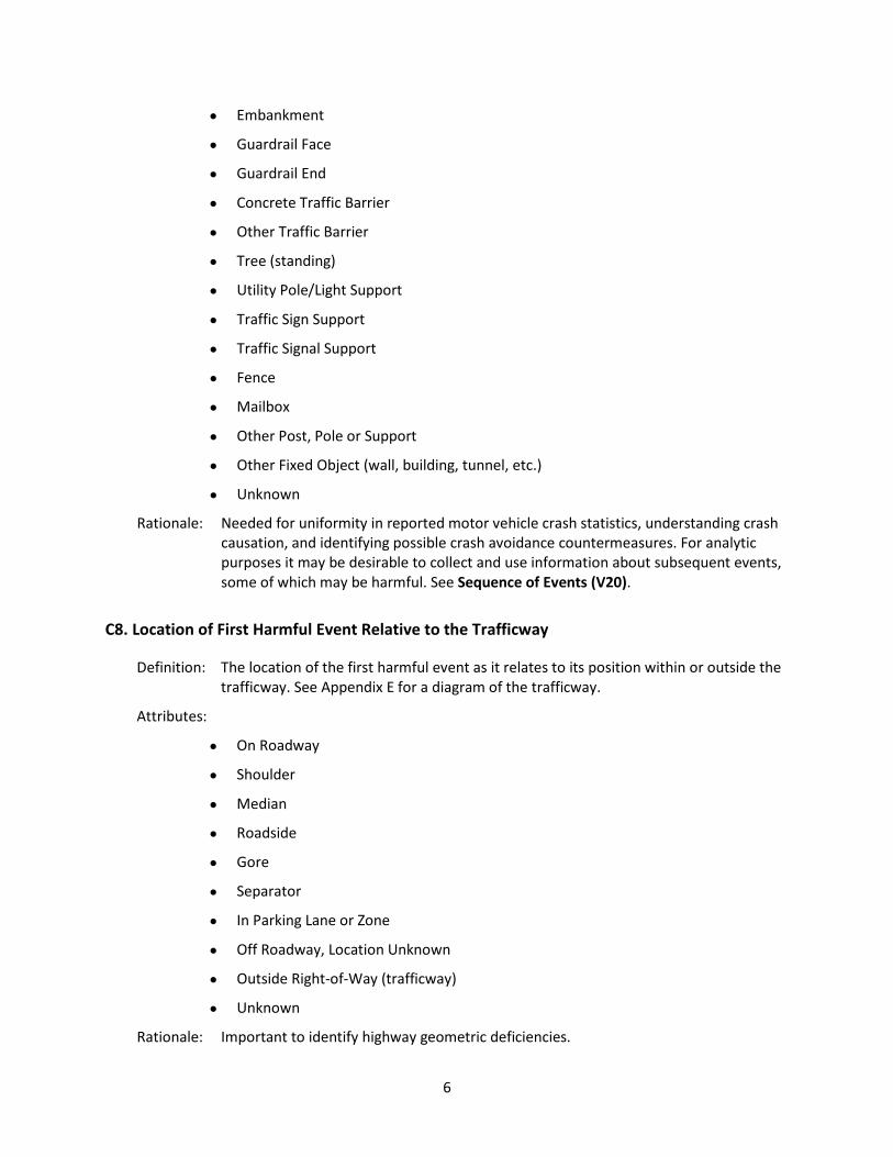
• Embankment
• Guardrail Face
• Guardrail End
• Concrete Traffic Barrier
• Other Traffic Barrier
• Tree (standing)
• Utility Pole/Light Support
• Traffic Sign Support
• Traffic Signal Support
• Fence
• Mailbox
• Other Post, Pole or Support
• Other Fixed Object (wall, building, tunnel, etc.)
• Unknown
Rationale: Needed for uniformity in reported motor vehicle crash statistics, understanding crash causation, and identifying possible crash avoidance countermeasures. For analytic purposes it may be desirable to collect and use information about subsequent events, some of which may be harmful. See Sequence of Events (V20).
C8. Location of First Harmful Event Relative to the Trafficway
Definition: The location of the first harmful event as it relates to its position within or outside the trafficway. See Appendix E for a diagram of the trafficway.
Attributes:
• On Roadway
• Shoulder
• Median
• Roadside
• Gore
• Separator
• In Parking Lane or Zone
• Off Roadway, Location Unknown
• Outside Right-of-Way (trafficway)
• Unknown
Rationale: Important to identify highway geometric deficiencies.

7
C9. Manner of Crash/Collision Impact
Definition: The identification of the manner in which two motor vehicles in transport initially came together without regard to the direction of force. This data element refers only to crashes where the first harmful event involves a collision between two motor vehicles in transport. See Appendix F for a diagram of the manner of collision.
Attributes:
• Front to Rear
• Front to Front
• Angle
• Sideswipe, Same Direction
• Sideswipe, Opposite Direction
• Rear to Side
• Rear to Rear
• Other
• Unknown
Rationale: Important for evaluation of occupant injuries and structural defects. This data element can be used in conjunction with Motor Vehicle Maneuver/Action (V18) to describe the crash.
C10. Source of Information
Definition: Affiliation of the person completing the crash report.
Attributes:
Source of Information:
• Law Enforcement Agency Identifier
• Motorist
Rationale: Important for quality control and identification purposes. The law enforcement reporting agency identifier is critical to report SAFETYNET crashes.
C11. Weather Conditions
Definition: The prevailing atmospheric conditions that existed at the time of the crash.
Attributes: Subfield 1:
Weather Condition 1
• Clear
• Cloudy

8
• Fog, Smog, Smoke
• Rain
• Sleet or Hail
• Freezing Rain or Freezing Drizzle
• Snow
• Blowing Snow
• Severe Crosswinds
• Blowing Sand, Soil, Dirt
• Other
• Unknown
Subfield 2:
Weather Condition 2 See attributes in Subfield 1
Rationale: Important for management/administration and evaluation. Critical for prevention programs and engineering evaluations.
C12. Light Condition
Definition: The type/level of light that existed at the time of the motor vehicle crash.
Attributes:
• Daylight
• Dawn
• Dusk
• Dark-Lighted
• Dark-Not Lighted
• Dark-Unknown Lighting
• Other
• Unknown
Rationale: Important for management/administration and evaluation. Critical for prevention programs and engineering evaluations.

9
C13. Roadway Surface Condition
Definition: The roadway surface condition at the time and place of a crash.
Attributes:
• Dry
• Wet
• Snow
• Slush
• Ice/Frost
• Water (standing, moving)
• Sand
• Mud, Dirt, Gravel
• Oil
• Other
• Unknown
Rationale: Important to identify and correct high wet-surface crash locations and provide information for setting coefficient of pavement friction standards. Critical for prevention programs and engineering evaluations.
C14. Contributing Circumstances, Environment
Definition: Apparent environmental conditions which may have contributed to the crash.
Attributes: Subfield 1:
Environmental Circumstances 1
• None
• Weather Conditions
• Visual Obstruction(s)
• Glare
• Animal(s) in Roadway
• Other
• Unknown
Subfield 2:
Environmental Circumstances 2 See attributes for Subfield 1
Subfield 3:
10
Environmental Circumstances 3 See attributes for Subfield 1
Rationale: Important to determine existence of unusual conditions that could be useful in determining the need for additional traffic control devices or geometric improvements. (Pedestrians and pedalcyclists are covered in traffic units.)
C15. Contributing Circumstances, Road
Definition: Apparent condition of the road which may have contributed to the crash.
Attributes: Subfield 1:
Road Circumstances 1
• None
• Backup Due to Prior Crash
• Backup Due to Prior Non-Recurring Incident
• Backup Due to Regular Congestion
• Toll Booth/Plaza Related
• Road Surface Condition (wet, icy, snow, slush, etc.)
• Debris
• Rut, Holes, Bumps
• Work Zone (construction/maintenance/utility)
• Worn, Travel-Polished Surface
• Obstruction in Roadway
• Traffic Control Device Inoperative, Missing, or Obscured
• Shoulders (none, low, soft, high)
• Non-Highway Work
• Other
• Unknown
Subfield 2:
Road Circumstances 2 See attributes in Subfield 1
Subfield 3:
Road Circumstances 3 See attributes in Subfield 1
Rationale: Important to determine highway maintenance and possible engineering needs.
11
C16. Relation to Junction
Definition: The coding of this data element is based on the location of the first harmful event of the crash. It identifies the crash's location with respect to presence in a junction or proximity to components typically in junction or interchange areas. See Appendices G and H.
Attributes: Subfield 1:
Within Interchange Area
• No
• Yes
• Unknown
Subfield 2:
Specific location
• Non-Junction
• Intersection
• Intersection-Related
• Entrance/Exit Ramp
• Entrance/Exit Ramp-Related
• Railway Grade Crossing
• Crossover-Related
• Driveway Access
• Driveway Access-Related
• Shared-Use Path or Trail
• Acceleration/Deceleration Lane
• Through Roadway
• Other Location Not Listed Above Within an Interchange Area (median, shoulder and roadside)
• Unknown
Rationale: Important for site-specific safety studies to identify locations with actual or potential problems.

12
C17. Type of Intersection
Definition: An intersection consists of two or more roadways that intersect at the same level. See Appendix H for a diagram of the intersection.
Attributes:
• Not an Intersection
• Four-Way Intersection
• T-Intersection
• Y-Intersection
• L-Intersection
• Traffic Circle
• Roundabout
• Five-Point, or More
Rationale: Important for site-specific safety studies to identify actual or potential safety problem locations.
C18. School Bus-Related
Definition: Indicates whether a school bus or motor vehicle functioning as a school bus for a school-related purpose is involved in the crash. The “school bus,” with or without a passenger on board, must be directly involved as a contact motor vehicle or indirectly involved as a non-contact motor vehicle (children struck when boarding or alighting from the school bus, two vehicles colliding as the result of the stopped school bus, etc.).
Attributes:
• No
• Yes, School Bus Directly Involved
• Yes, School Bus Indirectly Involved
Rationale: Important in determining where and how school children are at the greatest risk of injury when being transported by a school bus and the extent to which school bus operations affect overall traffic safety.
C19. Work Zone-Related (Construction/Maintenance/Utility)
Definition: A crash that occurs in or related to a construction, maintenance, or utility work zone, whether or not workers were actually present at the time of the crash. ”Work zone-related” crashes may also include those involving motor vehicles slowed or stopped because of the work zone, even if the first harmful event occurred before the first warning sign. See Appendix I for a diagram of the work zone area.

13
Attributes: Subfield 1:
Was the crash in a construction, maintenance, or utility work zone or was it related to activity within a work zone?
• Yes (complete Subfields 2-5)
• No
• Unknown
Subfield 2:
Location of the Crash:
• Before the First Work Zone Warning Sign
• Advance Warning Area
• Transition Area
• Activity Area
• Termination Area
Subfield 3:
Type of Work Zone:
• Lane Closure
• Lane Shift/Crossover
• Work on Shoulder or Median
• Intermittent or Moving Work
• Other
Subfield 4:
Workers Present:
• No
• Yes
• Unknown
Subfield 5:
Law Enforcement Present:
• No
• Officer Present
• Law Enforcement Vehicle Only Present
Rationale: Important to assess the impact on traffic safety of various types of on-highway work activity, to evaluate Traffic Control Plans used at work zones, and to make adjustments to Traffic Control Plans for the safety of workers and the traveling public. This data element needs to be collected at the scene because work zones are temporary or

14
moving operations that are not recorded in permanent road inventory files.
Vehicle Data Elements
The motor vehicle data elements describe the characteristics, events, and consequences of the motor vehicle(s) involved in the crash.
V1. Motor Vehicle Identification Number (VIN)
Definition: A unique combination of alphanumeric characters assigned to a specific motor vehicle
that is designated by the manufacturer.
Attribute:
• Manufacturer assigned number (permanently affixed to the motor vehicle)
Rationale: Important to identify specific motor vehicle design characteristics and occupant protection systems for effectiveness evaluations.
V2. Motor Vehicle Unit Type and Number
Definition: Motor vehicle unit type and number assigned to uniquely identify each motor vehicle involved in the crash. This number is not assigned to pedestrians or bicyclists. (See Non-Motorist Number (P22).)
Attributes: Subfield 1:
Type:
• Motor Vehicle in Transport
• Parked Motor Vehicle
• Working Vehicle/Equipment
Subfield 2:
Number
• Sequential number
Rationale: Uniquely identifies each motor vehicle unit involved in the crash. Permits occupants to be assigned to the appropriate motor vehicle.
V3. Motor Vehicle Registration State and Year
Definition: The State, commonwealth, territory, Indian nation, U.S. Government, foreign country, etc., issuing the registration plate and the year of registration as indicated on the registration plate displayed on the motor vehicle. For foreign countries, MMUCC requires only the name of the country. Border States may want to collect the name of individual Canadian Provinces or Mexican states. Refer to Appendix D.

15
Attributes:
• State Identifier
State, foreign country, U.S. government, Indian Nation, etc.
• Year of Motor Vehicle Registration (YYYY)
Rationale: This element is critical in providing linkage between the crash and motor vehicle registration files to access the motor vehicle identification number.
V4. Motor Vehicle License Plate Number
Definition: The alphanumeric identifier or other characters, exactly as displayed, on the registration plate or tag affixed to the motor vehicle. For combination trucks, motor vehicle plate number is obtained from the power unit or tractor.
Attribute:
• Alphanumeric Identifier
Assigned by the State, foreign country, U.S. Government, or Indian Nation.
Rationale: Critical for linkage between the crash and motor vehicle registration files.
V5. Motor Vehicle Make
Definition: The distinctive (coded) name applied to a group of motor vehicles by a manufacturer.
Attribute:
• Name
Assigned by motor vehicle manufacturer.
Rationale: Important for use in identifying motor vehicle make, for evaluation, research and crash comparison purposes.
V6. Motor Vehicle Model Year
Definition: The year which is assigned to a motor vehicle by the manufacturer.
Attribute:
• Model Year
YYYY as assigned by motor vehicle manufacturer (obtain from the vehicle registration).
Rationale: Important for use in identifying motor vehicle model year for evaluation, research, and crash comparison purposes.

16
V7. Motor Vehicle Model
Definition: The manufacturer-assigned code denoting a family of motor vehicles (within a make) that have a degree of similarity in construction, such as body, chassis, etc.
Attribute:
• Code for model
Assigned by motor vehicle manufacturer (obtain from the vehicle registration).
Rationale: Important for use in identifying the motor vehicle model for evaluation, research, and crash comparison purposes.
V8. Motor Vehicle Body Type Category
Definition: The category indicating the general configuration or shape of a motor vehicle distinguished by characteristics such as number of doors, rows of seats, windows, or roof line. Personal conveyances – such as skateboards, motorized toy cars, and wheelchairs are not considered motor vehicles.
Attributes:
• Passenger Car
• (Sport) Utility Vehicle
• Passenger Van
• Cargo Van (10,000 lbs GVWR or less)
• Pickup
• Motor Home
• School Bus
• Transit Bus
• Motorcoach
• Other Bus
• Motorcycle
• Moped
• Low Speed Vehicle
• Golf Cart
• All Terrain Vehicle (ATV)
• Snowmobile
• Other Light Trucks (10,000 lbs GVWR or less)
• Medium/Heavy Trucks (more than 10,000 lbs GVWR)

17
• Other
Rationale: Important to identify the specific type of motor vehicle involved in the crash for evaluation and comparison purposes.
V9. Total Occupants in Motor Vehicle
Definition: The total number of injured and uninjured occupants in this motor vehicle involved in the crash, including persons in or on the motor vehicle at the time of the crash.
Attribute:
• Total number of injured and uninjured occupants including the driver.
Rationale: Important for the officer at the scene to indicate how many people (injured and uninjured) are involved for reporting purposes. Useful for evaluating the effectiveness of countermeasures that prevent or reduce injury and injury severity.
V10. Special Function of Motor Vehicle in Transport
Definition: The type of special function being served by this vehicle regardless of whether the function is marked on the vehicle.
Attributes:
• No Special Function
• Taxi
• Vehicle Used as School Bus
• Vehicle Used as Other Bus
• Military
• Police
• Ambulance
• Fire Truck
• Non-Transport Emergency Services Vehicle
• Incident Response
• Unknown
Rationale: Important to evaluate the outcome of vehicles used for special uses that are involved in crashes.

18
V11. Emergency Motor Vehicle Use
Definition: Indicates operation of any motor vehicle that is legally authorized by a government authority to respond to emergencies with or without the use of emergency warning equipment, such as a police vehicle, fire truck, or ambulance while actually engaged in such response.
Attributes:
• Not applicable
• Non-Emergency, Non-Transport
• Non-Emergency Transport
• Emergency Operation, Emergency Warning Equipment Not in Use
• Emergency Operation, Emergency Warning Equipment in Use
• Unknown
Rationale: Driver behavior related to emergency vehicle response is an emerging national issue. This is true for both operators of emergency vehicles and operators of vehicles in the vicinity of an emergency vehicle engaged in a response. It is the intent of this element to gather information that will guide development of training or other countermeasures to reduce the number of crashes involving emergency vehicle response.
V12. Motor Vehicle Posted/Statutory Speed Limit
Definition: The posted/statutory speed limit for the motor vehicle at the time of the crash. The authorization may be indicated by the posted speed limit, blinking sign at construction zones, etc.
Attributes:
• Posted/Statutory Value (miles per hour)
• Not Applicable
• Unknown
Rationale: Important for evaluation purposes (even though the speed of the motor vehicle at the time of the crash may differ significantly from the authorized speed limit).
V13. Direction of Travel Before Crash
Definition: The direction of a motor vehicle’s travel on the roadway before the crash. Notice that this is not a compass direction, but a direction consistent with the designated direction of the road. For example, the direction of a State-designated North-South highway must be either northbound or southbound even though a motor vehicle may have been traveling due east as a result of a short segment of the highway having an east-west orientation.

19
Attributes:
• Northbound
• Southbound
• Eastbound
• Westbound
• Not on Roadway
• Unknown
Rationale: Important to indicate direction the motor vehicle was traveling before the crash for evaluation purposes.
V14. Trafficway Description
Definition: Indication of whether or not the trafficway for this vehicle is divided and whether it serves one-way or two-way traffic. A divided trafficway is one on which roadways for travel in opposite directions are physically separated by a median. See Appendix E for diagram of the trafficway.
Attributes:
• Two-Way, Not Divided
• Two-Way, Not Divided, With a Continuous Left Turn Lane
• Two-Way, Divided, Unprotected (Painted >4 Feet) Median
• Two-Way, Divided, Positive Median Barrier
• One-Way Trafficway
• Unknown
Rationale: Used in classifying crashes as well as identifying the environment of a particular crash. Note that the data must be in a road inventory file or collected by the reporting officer at the scene. It is not readily derived from other road data such as classification or route. Important to guide future trafficway design and traffic control.
V15. Total Lanes in Roadway
Definition: Total number of lanes in the roadway on which this motor vehicle was traveling.
Attributes:
For undivided highways:
• Enter the total through lanes in both directions, excluding designated turn lanes.
For divided highways:
• Enter the total through lanes for the roadway on which the motor vehicle under consideration was traveling. See Appendix E for diagram of the trafficway.

20
Rationale: Used in studying roadway safety issues as well as identifying the environment of a particular crash.
V16. Roadway Alignment and Grade
Definition: The geometric or layout and inclination characteristics of the roadway in the direction of travel for this vehicle.
Attributes: Subfield 1:
Horizontal Alignment:
• Straight
• Curve Left
• Curve Right
Subfield 2:
Grade:
• Level
• Hillcrest
• Uphill
• Downhill
• Sag (bottom)
Rationale: Important to document the horizontal alignment and grade of the roadway as it relates to this specific vehicle involved in the crash for the purpose of evaluating vehicles that run-off-road, rollover, or are runaways.
V17. Traffic Control Device Type
Definition: The type of traffic control device (TCD) applicable to this motor vehicle at the crash location.
Attributes: Subfield 1:
Type TCD:
• No Controls
• Person (including flagger, law enforcement, crossing guard, etc.)
• Traffic Control Signal
• Flashing Traffic Control Signal
• School Zone Sign/Device
• Stop Sign
• Yield Sign

21
• Warning Sign
• Railway Crossing Device
• Other
• Unknown
Subfield 2:
Inoperative/Missing?
• Yes
• No
• Unknown
Rationale: This element needs to be collected at the scene because the presence of specific devices is better verified at the time of the crash. It is also important for ascertaining the relationship between the use of various traffic control devices (TCD) and crashes and identifying the need for upgraded TCDs at specific crash locations.
V18. Motor Vehicle Maneuver/Action
Definition: The controlled maneuver for this motor vehicle prior to the beginning of the sequence of events.
Attributes:
• Movements Essentially Straight Ahead
• Negotiating a Curve
• Backing
• Changing Lanes
• Overtaking/Passing
• Turning Right
• Turning Left
• Making U-Turn
• Leaving Traffic Lane
• Entering Traffic Lane
• Slowing
• Parked
• Stopped in Traffic
• Other
• Unknown
Rationale: Important for crash evaluation, particularly when combined with sequence of events.
22
V19. Vehicle Damage
Definition: Subfield 1 of this element is intended to collect the approximate contact point on this vehicle associated with this vehicle’s initial harmful event. If the initial harmful event does not involve a collision, then code “Non-Collision” (refer to glossary). Subfield 2 identifies all areas damaged on the vehicle as a result of this crash. Subfield 3 identifies the extent to which the damage affects the vehicle’s operability rather than the cost to repair.
Attributes: Subfield 1:
Initial Contact Point on Vehicle:
• Non-Collision
• 12-point Clock Diagram (Appendix J)
• Top
• Undercarriage
• Cargo loss
• Unknown
Subfield 2:
Damaged Areas:
• 12-point Clock Diagram (Appendix J)
• Top
• Undercarriage
• All Areas
• No Damage
• Unknown
Subfield 3:
Extent of Damage
• No Damage
• Minor Damage
• Functional Damage
• Disabling Damage
• Unknown
Rationale: Important for use in evaluating injury severity in relation to motor vehicle impact and crash severity.

23
V20. Sequence of Events
Definition: The events in sequence related to this motor vehicle, including both non-collision as well as collision events. For examples, refer to Appendix L.
Attributes: Subfield 1:
First Event
Non-Collision:
• Overturn/Rollover
• Fire/Explosion
• Immersion, Full or Partial
• Jackknife
• Cargo/Equipment Loss or Shift
• Equipment Failure (blown tire, brake failure, etc.)
• Separation of Units
• Ran Off Roadway Right
• Ran Off Roadway Left
• Cross Median
• Cross Centerline
• Downhill Runaway
• Fell/Jumped From Motor Vehicle
• Reentering Roadway
• Thrown or Falling Object
• Other Non-Collision
Collision With Person, Motor Vehicle, or Non-Fixed Object:
• Pedestrian
• Pedalcycle
• Other Non-motorist
• Railway Vehicle (train, engine)
• Animal (live)
• Motor Vehicle In Transport
• Parked Motor Vehicle
• Struck By Falling, Shifting Cargo or Anything Set in Motion By Motor Vehicle
• Work Zone/Maintenance Equipment

24
• Other Non-Fixed Object
Collision With Fixed Object:
• Impact Attenuator/Crash Cushion
• Bridge Overhead Structure
• Bridge Pier or Support
• Bridge Rail
• Cable Barrier
• Culvert
• Curb
• Ditch
• Embankment
• Guardrail Face
• Guardrail End
• Concrete Traffic Barrier
• Other Traffic Barrier
• Tree (standing)
• Utility Pole/Light Support
• Traffic Sign Support
• Traffic Signal Support
• Other Post, Pole, or Support
• Fence
• Mailbox
• Other Fixed Object (wall, building, tunnel, etc.)
• Unknown
Subfield 2:
Second Event See attributes in Subfield 1
Subfield 3:
Third Event See attributes in Subfield 1
Subfield 4:
Fourth Event See attributes in Subfield 1

25
Rationale: Important for use in conjunction with most harmful event and motor vehicle maneuver to generate complete information about the crash.
V21. Most Harmful Event for this Motor Vehicle
Definition: Event that resulted in the most severe injury or, if no injury, the greatest property damage involving this motor vehicle.
Attributes:
Non-Collision:
• Overturn/Rollover
• Fire/Explosion
• Immersion, full or partial
• Jackknife
• Cargo/Equipment Loss or Shift
• Fell/Jumped From Motor Vehicle
• Thrown or Falling Object
• Other Non-Collision
Collision With Person, Motor Vehicle, or Non-Fixed Object:
• Pedestrian
• Pedalcycle
• Other Non-motorist
• Railway Vehicle (train, engine)
• Animal (live)
• Motor Vehicle in Transport
• Parked Motor Vehicle
• Struck by Falling, Shifting Cargo or Anything Set in Motion by Motor Vehicle
• Work Zone / Maintenance Equipment
• Other Non-Fixed Object
Collision With Fixed Object:
• Impact Attenuator/Crash Cushion
• Bridge Overhead Structure
• Bridge Pier or Support
• Bridge Rail
• Cable Barrier

26
• Culvert
• Curb
• Ditch
• Embankment
• Guardrail Face
• Guardrail End
• Concrete Traffic Barrier
• Other Traffic Barrier
• Tree (standing)
• Utility Pole/Light Support
• Traffic Sign Support
• Traffic Signal Support
• Other Post, Pole, or Support
• Fence
• Mailbox
• Other Fixed Object (wall, building, tunnel, etc.)
• Unknown
Unknown
Rationale: Important for use in conjunction with the Sequence of Events (V20) to generate complete information about the crash.
V22. Bus Use
Definition: This element describes the common type of bus service this vehicle was being used as at the time of the crash. Buses are any motor vehicle with seats to transport nine (9) or more people, including the driver’s seat. This element does not include vans which are owned and operated for personal use. Refer to the Glossary for attribute definitions.
Attributes:
• Not a Bus
• School
• Transit/Commuter
• Intercity
• Charter/Tour
• Shuttle
27
Rationale: This data element provides additional information to evaluate the outcome of motor vehicles used as buses that are involved in crashes.
V23. Hit and Run
Definition: Refers to cases where the vehicle or the driver of the vehicle in transport is a contact vehicle in the crash and departs the scene without stopping to render aid or report the crash.
Attributes:
• No, Did Not Leave Scene
• Yes, Driver or Car and Driver Left Scene
Rationale: Important for uniformity, quality control and identification purposes in reported motor vehicle crash statistics.
V24. Towed Due to Disabling Damage
Definition: Disabling damage implies damage to the motor vehicle that is sufficient to require the motor vehicle to be towed or carried from the scene. Towed Due to Disabling Damage identifies if a vehicle involved in a crash is removed from the scene due to damage incurred. Towing assistance without removal of the vehicle from the scene, such as pulling a vehicle out of a ditch, is not considered to be “towed” for the purposes of this element.
Attributes:
• Towed Due to Disabling Damage
• Towed, But Not Due to Disabling Damage
• Not Towed
Rationale: Towed Due to Disabling Damage is important for identifying non-injury, “tow-away” crashes due to damage sustained in the crash. This information is vital to Federal Motor Carrier Safety Administration in their selection criteria for truck and bus crashes.
V25. Contributing Circumstances, Motor Vehicle
Definition: Pre-existing motor vehicle defects or maintenance conditions that may have contributed to the crash.
Attributes:
• None
Subfield 1:
Motor Vehicle Circumstance 1:
• Brakes
28
• Exhaust System
• Body, Doors
• Steering
• Power Train
• Suspension
• Tires
• Wheels
• Lights (head, signal, tail)
• Windows/Windshield
• Mirrors
• Wipers
• Truck Coupling / Trailer Hitch / Safety Chains
• Other
• Unknown
Subfield 2:
Motor Vehicle Circumstance 2 See attributes in Subfield 1
Rationale: Important for determining the significance of pre-existing problems, including equipment and operation, in motor vehicles involved in crashes that could be useful in determining the need for improvements in manufacturing and consumer alerts.
V26. Motor Carrier Identification**
Definition: The identification number, name and address of an individual, partnership or corporation responsible for the transportation of persons or property as indicated on the shipping manifest.
Attributes: Subfield 1:
• US DOT Number (7 digits, right justified)
Subfield 2:
• If no US DOT Number, State Issued Identification Number and State name
Subfield 3:
• Name
Subfield 4:
Street Address

29
• Street or P.O. Box
• City
• State (two-letter code)
• Zip Code
• Country
Subfield 5:
Commercial/Non-Commercial
• Interstate Carrier
• Intrastate Carrier
• Not in Commerce/Government
• Not in Commerce/Other Truck
Rationale: (**Required by the Federal Motor Carrier Safety Administration CFR 350.201.) The Federal Motor Carrier Safety Administration (FMCSA) has the authority to fine and sanction unsafe interstate (and some intrastate) truck and bus companies. A key way to identify potentially unsafe motor carriers is to collect crash data by the identification number, name, and address of the company. The street address allows FMCSA to visit carriers to conduct review of compliance with Federal Motor Carrier Safety Regulations and provides a crosscheck for the correct identity of the carrier. The identification number (found on the power unit, and assigned by the U.S. DOT or by a State) is a key element for carrier identification in the FMCSA databases for crashes and other carrier information. This data element is collected at the scene to meet FMCSA 90 day reporting requirements.
V27. Gross Vehicle Weight Rating / Gross Combination Weight Rating**
Definition: The Gross Vehicle Weight Rating (GVWR) is the amount recommended by the manufacturer as the upper limit to the operational weight for a motor vehicle and any cargo (human or other) to be carried. The Gross Combination Weight Rating (GCWR) is the sum of all GVWRs for each unit in a combination unit motor vehicle. Thus for single-unit trucks there is no difference between the GVWR and the GCWR. For combination trucks (truck tractors pulling a single semi-trailer, truck tractors pulling double or triple trailers, trucks pulling trailers, and trucks pulling other motor vehicles) the GCWR is the total of the GVWRs of all units in the combination.
Attributes:
• Not Applicable
• 10,000 lbs or less
• 10,001-26,000 lbs
• More than 26,000 lbs
Rationale: (**Required by the Federal Motor Carrier Safety Administration CFR 350.201.) The

30
FMCSA imposes certain regulations on all single or combination-unit trucks that have a Gross Combination Weight Rating (GCWR) of more than 10,000 lbs. Additional regulations are imposed on all motor vehicles with GCWRs of more than 26,000 lbs. This data element is collected at the scene because FMCSA requires reporting within 90 days.
V28. Vehicle Configuration**
Definition: Indicates the general configuration of this motor vehicle. (Refer to Appendix K for a chart displaying types of truck configurations.)
Attributes:
• Vehicle 10,000 pounds or less placarded for hazardous materials
• Single-Unit Truck (2-axle and GVWR more than10,000 lbs)
• Single-Unit Truck (3 or more axles)
• Truck Pulling Trailer(s)
• Truck Tractor (bobtail)
• Truck Tractor/Semi-Trailer
• Truck Tractor/Double
• Truck Tractor/Triple
• Truck More Than 10,000 lbs., Cannot Classify
• Bus/Large Van (seats for 9-15 occupants, including driver)
• Bus (seats for more than 15 occupants, including driver)
• Unknown
Rationale: (**Required by the Federal Motor Carrier Safety Administration CFR 350.201.) This data element provides information about the general configuration of the motor vehicle that is important to evaluate the types of motor vehicles that have the most crashes and the effectiveness of various safety countermeasures. This data element is collected at the scene because FMCSA requires reporting within 90 days.
V29. Cargo Body Type**
Definition: The type of body for buses and trucks more than 10,000 lbs GVWR. (Refer to Appendix K for chart displaying types of cargo body types.)
Attributes:
• No Cargo Body – (bobtail, light motor vehicle with hazardous materials [HM] placard, etc.)
• Bus
• Van/Enclosed Box
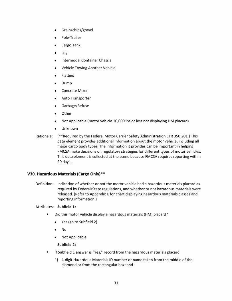
31
• Grain/chips/gravel
• Pole-Trailer
• Cargo Tank
• Log
• Intermodal Container Chassis
• Vehicle Towing Another Vehicle
• Flatbed
• Dump
• Concrete Mixer
• Auto Transporter
• Garbage/Refuse
• Other
• Not Applicable (motor vehicle 10,000 lbs or less not displaying HM placard)
• Unknown
Rationale: (**Required by the Federal Motor Carrier Safety Administration CFR 350.201.) This data element provides additional information about the motor vehicle, including all major cargo body types. The information it provides can be important in helping FMCSA make decisions on regulatory strategies for different types of motor vehicles. This data element is collected at the scene because FMCSA requires reporting within 90 days.
V30. Hazardous Materials (Cargo Only)**
Definition: Indication of whether or not the motor vehicle had a hazardous materials placard as required by Federal/State regulations, and whether or not hazardous materials were released. (Refer to Appendix K for chart displaying hazardous materials classes and reporting information.)
Attributes: Subfield 1:
Did this motor vehicle display a hazardous materials (HM) placard?
• Yes (go to Subfield 2)
• No
• Not Applicable
Subfield 2:
If Subfield 1 answer is “Yes,” record from the hazardous materials placard:
1) 4-digit Hazardous Materials ID number or name taken from the middle of the diamond or from the rectangular box; and

32
2) 1-digit Class number from bottom of diamond
Subfield 3:
Release of hazardous materials from the package (cargo compartment):
Hazardous materials that were released from the package (cargo compartment) should be documented whether or not the motor vehicle displayed a placard.
• Yes
• No
• Not Applicable
Rationale: (**Required by the Federal Motor Carrier Safety Administration CFR 350.201.) FMCSA devotes special attention to motor carriers that transport hazardous materials (HM), including calculating risk assessments, determining response methods, imposing tighter regulations and conducting compliance reviews on a higher percentage of HM carriers. Getting good data on crashes involving trucks carrying HM and whether HM are spilled during the crashes helps FMCSA focus law enforcement efforts. This data element is collected at the scene because FMCSA requires reporting within 90 days.
Person Data Elements
The person data elements describe the characteristics, actions, and consequences to the persons involved in the crash.
Level 1: All Persons Involved
P1. Name of Person Involved
Definition: The full name of the individual involved in the crash.
Attributes:
• Name
Rationale: This data element should be collected to facilitate linkage when names are available in the health and insurance files and to corroborate the driver license number of drivers. When possible, obtain this information from the driver license.
P2. Date of Birth
Definition: The year, month, and day of birth, (or age to be used only when date of birth cannot be obtained), of the person involved in a crash.
Attributes: Subfield 1:
Date of Birth
• YYYYMMDD
• Unknown

33
Subfield 2:
Age
• AAA
Rationale: Accurate reporting of date of birth is used to assess the effectiveness of occupant protection systems for specific age groups, and to identify the need for safety programs directed toward them. This element is also critical in providing linkage between the crash, EMS, and hospital records.
P3. Sex
Definition: The sex of the person involved in the crash.
Attributes:
• Male
• Female
• Unknown
Rationale: Necessary, for example, to evaluate the effect of sex of the person involved on occupant protection systems and motor vehicle design characteristics.
P4. Person Type
Definition: Type of person involved in a crash.
Attributes:
Motorist
• Driver
• Passenger
Non-Motorist (nonoccupant of vehicle in transport):
• Pedestrian
• Other Pedestrian (wheelchair, person in a building, skater, personal conveyance, etc.)
• Bicyclist
• Other Cyclist
• Occupant of Motor Vehicle Not in Transport (parked, etc.)
• Occupant of a Non-Motor Vehicle Transportation Device
• Unknown Type of Non-Motorist
Unknown
Rationale: Need to know person type for classification purposes to evaluate specific

34
countermeasure designed for specific people.
P5. Injury Status
Definition: The injury severity level for a person Involved in a crash. The determination of which attribute to assign should be based on the latest information available at the time the report is completed, except as described below for fatal Injuries.
NOTE: Attribute definitions are provided for Injury Status to emphasize that some attribute names and definitions have changed from the 3rd Edition of MMUCC even though the “KABCO” acronym remains. Most notably, “Suspected Serious Injury” (A) has replaced “Incapacitating Injury” and “Suspected Minor Injury” (B) has replaced “Non-incapacitating Injury.”
Attributes:
• Fatal Injury (K): A fatal injury is any injury that results in death within 30 days after the motor vehicle crash in which the injury occurred. If the person did not die at the scene but died within 30 days of the motor vehicle crash in which the injury occurred, the injury classification should be changed from the attribute previously assigned to the attribute “Fatal Injury.”
• Suspected Serious Injury (A): A suspected serious injury is any injury other than fatal which results in one or more of the following:
Severe laceration resulting in exposure of underlying tissues/muscle/organs or resulting in significant loss of blood
Broken or distorted extremity (arm or leg) Crush injuries Suspected skull, chest or abdominal injury other than bruises or minor lacera-
tions Significant burns (second and third degree burns over 10% or more of the body) Unconsciousness when taken from the crash scene Paralysis
• Suspected Minor Injury (B): A minor injury is any injury that is evident at the scene of the crash, other than fatal or serious injuries. Examples include lump on the head, abrasions, bruises, minor lacerations (cuts on the skin surface with minimal bleeding and no exposure of deeper tissue/muscle).
• Possible Injury (C): A possible injury is any injury reported or claimed which is not a fatal, suspected serious or suspected minor injury. Examples include momentary loss of consciousness, claim of injury, limping, or complaint of pain or nausea. Possible injuries are those which are reported by the person or are indicated by his/her behavior, but no wounds or injuries are readily evident.
• No Apparent Injury (O): No apparent injury is a situation where there is no reason to believe that the person received any bodily harm from the motor vehicle crash. There is no physical evidence of injury and the person does not report any change in normal function.

35
Rationale: Necessary for injury outcome analysis and evaluation. This element is also critical in providing linkage between the crash, EMS, and hospital records.
Level 2: All Occupants
P6. Occupant’s Motor Vehicle Unit Number
Definition: The unique number assigned for this crash to the motor vehicle in which this person was an occupant. Persons ejected or who fall from a vehicle are still considered occupants.
Attribute:
• Number to indicate in which motor vehicle the occupant was located.
Rationale: Important to link occupants back to motor vehicles in which they were riding. Necessary, for example, to evaluate the effect motor vehicle type and specific make/model have on occupant protection effectiveness and injury status.
P7. Seating Position
Definition: The location for this occupant in, on, or outside of the motor vehicle prior to the first event in the sequence of events. Refer to Appendix N for diagram of common vehicle types, to include ambulance seating/positioning.
Attributes: Subfield 1:
Row:
• Front
• Second
• Third
• Fourth
• Other Row (bus, 15 passenger van, etc.)
• Unknown
Subfield 2:
Seat:
• Left (usually the motor vehicle or motorcycle driver except for postal vehicles and some foreign vehicles)
• Middle
• Right
• Other
• Unknown

36
Subfield 3:
Other Location
• Not Applicable
• Sleeper Section of Cab (truck)
• Other Enclosed Cargo Area
• Unenclosed Cargo Area
• Trailing Unit
• Riding on Motor Vehicle Exterior (non-trailing unit)
• Unknown
Rationale: Without known seating position for each person in the motor vehicle, it is not possible to fully evaluate, for example, the effect of occupant protection programs.
P8. Restraint Systems / Motorcycle Helmet Use
Definition: The restraint equipment in use by the occupant, or the helmet use by a motorcyclist, at the time of the crash.
Attributes: Subfield 1:
Restraint Systems
• Not Applicable
• None Used – Motor Vehicle Occupant
• Shoulder and Lap Belt Used
• Shoulder Belt Only Used
• Lap Belt Only Used
• Restraint Used – Type Unknown
• Child Restraint System – Forward Facing
• Child Restraint System – Rear Facing
• Booster Seat
• Child Restraint – Type Unknown
• Other
• Unknown
Subfield 2:
Motorcycle Helmet Use
• DOT-Compliant Motorcycle Helmet
• Helmet, Other Than DOT-Compliant Motorcycle Helmet
37
• Helmet, Unknown If DOT-Compliant
• No Helmet
• Unknown If Helmet Worn
Rationale: Proper classification of the use of available occupant restraint systems and helmet use is vital to evaluating the effectiveness of such equipment.
P9. Air Bag Deployed
Definition: Deployment status of an air bag relative to the position in the vehicle for this occupant. Refer to Appendix M for a diagram of air bag types.
Attributes:
• Not Applicable
• Not Deployed
• Deployed-Front
• Deployed-Side
• Deployed-Curtain
• Deployed-Other (knee, air belt, etc.)
• Deployed-Combination
• Deployment Unknown
Rationale: Necessary to evaluate the effectiveness of air bags and other occupant protection equipment, especially at a time when air bags are becoming standard equipment.
P10. Ejection
Definition: Occupant completely or partially thrown from the interior of the motor vehicle, excluding motorcycles, as a result of a crash.
Attributes:
• Not Ejected
• Ejected, Partially
• Ejected, Totally
• Not Applicable
• Unknown
Rationale: Occupant protection systems prevent or mitigate ejections to various degrees. Analyses of the effectiveness of safety systems depend on information from this data element.

38
Level 3: All Drivers
P11. Driver License Jurisdiction
Definition: The geographic or political entity issuing a driver license. Includes the States of the United States (including the District of Columbia and outlying areas), Indian Nations, U.S. Government, Canadian Provinces, and Mexican States (including the Distrito Federal), as well as other jurisdictions.
Attributes:
• Not Applicable
• Not Licensed
• State
• Indian Nation
• U.S. Government
• Canadian Province
• Mexican State
• International License (other than Mexico, Canada)
• Unknown
Rationale: Necessary to evaluate the effectiveness of various licensing laws. This element is also critical in providing linkage between the crash and driver license files at the State level.
P12. Driver License Number, Class, CDL and Endorsements**
Definition: A unique set of alphanumeric characters assigned by the authorizing agent issuing a driver license to the individual.
Attributes: Subfield 1:
• License Number – Alphanumeric identifier assigned by the authorizing jurisdiction (State, foreign country, U.S. government, Indian Nation, etc.).
Subfield 2:
Class This indicates the type of driver’s license issued by the State and the type of motor vehicle the driver is qualified to drive.
• None
• Not Applicable
• Class A
Any combination of vehicles with a gross combination weight rating (GCWR) of 26,001 pounds or more provided the GVWR of the vehicle(s) being towed is in excess of 10,000 pounds.

39
• Class B
Any single vehicle with a GVWR of 26,001 or more pounds, or any such vehicle towing a vehicle not in excess of 10,000 pounds GVWR.
• Class C
Any single vehicle, or combination of vehicles, that does not meet the definition of Class A or Class B, but is either designed to transport 16 or more passengers, including the driver, or is used in the transportation of materials found to be hazardous which require the motor vehicle to be placarded.
• Regular Driver License Class
Any regular or standard driver license issued for the operation of automobiles and light trucks by States that separate these vehicles from Class “C”. Other class designation codes such as “D”, “R” and others may be used by States to indicate a regular driver license class.
• Class M
Motorcycles, Mopeds, Motor-Driven Cycles
Subfield 3:
Commercial Driver License (CDL)
This indicates whether the driver license is a commercial driver license (CDL). Also, this information is important to separate the non-commercial licenses included by some States in Class C with the commercial licenses.
• No
• Yes
Subfield 4:
Endorsements
This indicates any endorsements to the driver license, both commercial and non-commercial.
• None/Not Applicable
• T - Double/Triple Trailers
• P - Passenger
• N - Tank Vehicle
• H - Hazardous Materials
• X - Combination of Tank Vehicle and Hazardous Materials
• S - School
• Other non-commercial license endorsements (e.g., motorcycle, etc.)
Rationale: This information is mandated by FMCSA for commercial drivers. This element is critical to providing linkage between the crash and driver license files at the State level.

40
P13. Speeding Related
Definition: Indication of whether the investigating officer suspects that the driver involved in the crash was speeding based on verbal or physical evidence and not on speculation alone.
Attributes:
• Racing
• Exceeded Speed Limit
• Too Fast for Conditions
• No
• Unknown
Rationale: Important for evaluating preventive programs and engineering assessments.
P14. Driver Actions at Time of Crash
Definition: The actions by the driver that may have contributed to the crash. This data element is based on the judgment of the law enforcement officer investigating the crash and need not match Violation Codes (P15).
Attributes: Subfield 1:
Driver Action 1
• No Contributing Action
• Ran Off Roadway
• Failed to Yield Right-of-Way
• Ran Red Light
• Ran Stop Sign
• Disregarded Other Traffic Sign
• Disregarded Other Road Markings
• Improper Turn
• Improper Backing
• Improper Passing
• Wrong Side or Wrong Way
• Followed Too Closely
• Failed to Keep in Proper Lane
• Operated Motor Vehicle in Reckless or Aggressive Manner
• Operated Motor Vehicle in Inattentive, Careless, Negligent, or Erratic Manner
• Swerved or Avoided Due to Wind, Slippery Surface, Motor Vehicle, Object,

41
Non-Motorist in Roadway, etc.
• Over-Correcting/Over-Steering
• Other Contributing Action
• Unknown
Subfield 2:
Driver Action 2 See attributes in Subfield 1
Subfield 3:
Driver Action 3 See attributes in Subfield 1
Subfield 4:
Driver Action 4 See attributes in Subfield 1
Rationale: Important for evaluating the effect that dangerous driver behavior has on crashes.
P15. Violation Codes
Definition: All motor vehicle-related violations codes, if any, which apply to this driver.
Attributes: Subfield 1:
Violation Code 1
• No Violation
• (Violation Code)
• Unknown
Subfield 2:
Violation Code 2 See codes in Subfield 1
Rationale: Important for evaluation of safety laws and enforcement practices. This information is not available from the driver license file.
P16. Driver Distracted By
Definition: Distractions which may have influenced the driver performance. The distractions can be inside the motor vehicle (internal) or outside the motor vehicle (external).
Attributes:
• Not Distracted
• Manually Operating an Electronic Communication Device (texting, typing, dialing)
42
• Talking on Hands-Free Electronic Device
• Talking on Hand-Held Electronic Device
• Other Activity, Electronic Device
• Passenger
• Other Inside the Vehicle (eating, personal hygiene, etc.)
• Outside the Vehicle (includes unspecified external distractions)
• Unknown if Distracted
Rationale: Important to identify specific driver behavior during a crash and understand and mitigate the effects of distracting activities.
Level 4: All Drivers and Non-motorists
P17. Condition at Time of the Crash
Definition: Any relevant condition of the individual (motorist or non-motorist) that is directly related to the crash.
Attributes: Subfield 1:
Condition 1
• Apparently Normal
• Physically Impaired
• Emotional (depressed, angry, disturbed, etc.)
• Ill (sick), Fainted
• Asleep or Fatigued
• Under the Influence of Medications/Drugs/Alcohol
• Other
• Unknown
Subfield 2:
Condition 2:
• Physically Impaired
• Emotional (depressed, angry, disturbed, etc.)
• Ill (sick), Fainted
• Asleep or Fatigued
• Under the Influence of Medications/Drugs/Alcohol
• Other
Rationale: Important for evaluating the effect that fatigue, medications/alcohol/drugs, or other

43
conditions have on the crash.
P18. Law Enforcement Suspects Alcohol Use
Definition: Driver or non-motorist involved in the crash suspected by law enforcement to have used alcohol.
Attributes:
• No
• Yes
• Unknown
Rationale: Alcohol-related crashes remain a serious traffic safety problem. Identifying crashes in which alcohol may have been involved will help evaluate the effectiveness of programs to decrease the incidence of drunk driving or to identify problem areas.
P19. Alcohol Test
Definition: Indication of the presence of alcohol by test, type, and result.
Attributes: Subfield 1:
Test Status:
• Test Not Given
• Test Refused
• Test Given
• Unknown if Tested
Subfield 2:
Type of Test:
• Blood
• Breath
• Urine
• Other
Subfield 3:
BAC Test Result:
• Value
• Pending
• Unknown
Rationale: Alcohol remains the most prevalent drug involved in motor vehicle crashes. Capturing alcohol concentration whenever a driver or non-motorist is tested will provide an
44
accurate assessment of the role of alcohol involvement. The type of test used to obtain the alcohol concentration also is important information to collect.
P20. Law Enforcement Suspects Drug Use
Definition: Driver or non-motorist involved in the crash suspected by law enforcement to have used drugs.
Attributes:
• No
• Yes
• Unknown
Rationale: Drug-related crashes remain a serious traffic safety problem. Identifying crashes in which drugs may have been involved will help evaluate the effectiveness of programs to decrease the incidence of driving while under the influence of drugs.
P21. Drug Test
Definition: Indication of the presence of drug test, type, and result. Excludes drugs administered post-crash. See Drug Test Result (PL3) to document drug name.
Attributes: Subfield 1:
Test Status:
• Test Not Given
• Test Refused
• Test Given
• Unknown if Tested
Subfield 2:
Type of Test:
• Blood
• Urine
• Other
Subfield 3:
Drug Test Result:
• Positive
• Negative
• Unknown
Rationale: Identifying drug-related crashes help develop and evaluate programs directed at

45
reducing their involvement. Whenever evidence of other drug use is available, it should be captured.
Level 5: Non-Motorists (includes occupants of motor vehicles not in transport and occupants of non-motor vehicle transportation devices)
P22. Non-Motorist Number
Definition: The unique number assigned to the non-motorist involved in the crash.
Attribute:
• Sequential Number (uniquely identifying the non-motorist involved in the crash)
Rationale: Important for management/administration and evaluation. Needed to determine number and type of non-motorists involved in crash. Needed to track non-motorist action before the crash as well as injuries sustained.
P23. Non-Motorist Action/Circumstance Prior to Crash
Definition: The action of the non-motorist immediately prior to the crash and an indication of whether the non-motorist was walking/cycling to/from school.
Attributes: Subfield 1:
Action/Circumstances:
• Crossing Roadway
• Waiting to Cross Roadway
• Walking/Cycling Along Roadway with Traffic (In or Adjacent to Travel Lane)
• Walking/Cycling Along Roadway Against Traffic (In or Adjacent to Travel Lane)
• Walking/Cycling on Sidewalk
• In Roadway – Other
• Adjacent to Roadway (e.g., Shoulder, Median)
• Working in Trafficway (Incident Response)
• Other
• None
• Unknown
Subfield 2:
Going to or from School (K-12)
• No
• Yes

46
• Unknown
Rationale: The development of effective roadway design and operation, education, and enforcement measures to accommodate pedestrians and bicyclists and prevent crashes with motor vehicles is enhanced by the collection of the actions and circumstances prior to the crash.
P24. Non-Motorist Actions/Circumstances at Time of Crash
Definition: The actions/circumstances of the non-motorist that may have contributed to the crash. This data element is based on the judgment of the law enforcement officer investigating the crash.
Attributes: Subfield 1:
Non-Motorist Contributing Action/Circumstance 1
• No Improper Action
• Dart/Dash
• Failure to Yield Right-Of-Way
• Failure to Obey Traffic Signs, Signals, or Officer
• In Roadway Improperly (Standing, Lying, Working, Playing)
• Disabled Vehicle Related (Working on, Pushing, Leaving/Approaching)
• Entering/Exiting Parked/Standing Vehicle
• Inattentive (Talking, Eating, etc.)
• Not Visible (Dark Clothing, No Lighting, etc.)
• Improper Turn/Merge
• Improper Passing
• Wrong-Way Riding or Walking
• Other
• Unknown
Subfield 2:
Non-Motorist Contributing Action/Circumstance 2 See attributes in Subfield 1
Rationale: The development of effective roadway design and operation, education, and enforcement measures to accommodate pedestrians and cyclists and prevent crashes with motor vehicles is enhanced by the collection of the actions and circumstances at the time of the crash.

47
P25. Non-Motorist Location at Time of Crash
Definition: The location of the non-motorist with respect to the roadway at the time of crash.
Attributes:
• Intersection – Marked Crosswalk
• Intersection – Unmarked Crosswalk
• Intersection – Other
• Midblock – Marked Crosswalk
• Travel Lane – Other Location
• Bicycle Lane
• Shoulder/Roadside
• Sidewalk
• Median/Crossing Island
• Driveway Access
• Shared-Use Path or Trail
• Non-Trafficway Area
• Other
• Unknown
Rationale: The development of effective roadway design and operation, education, and enforcement measures to accommodate pedestrians and cyclists and prevent crashes with motor vehicles is enhanced by the collection of the location of the non-motorist at the time of crash.
P26. Non-Motorist Safety Equipment
Definition: The safety equipment(s) used by the non-motorist.
Attributes: Subfield 1:
Safety Equipment Used by Non-Motorist
• None
• Helmet
• Protective Pads Used (elbows, knees, shins, etc.)
• Reflective Clothing (jacket, backpack, etc.)
• Lighting
• Other
• Not Applicable
48
• Unknown
Subfield 2:
Safety Equipment Used by Non-Motorist See attributes in Subfield 1
Rationale: Used to evaluate effectiveness of non-motorist safety equipment. Important to calculate usage statistics for the development and evaluation of the effectiveness of educational countermeasures. The use of two sub-fields allows for the recording of two types of safety equipment, such as a helmet and reflective clothing.
P27. Unit Number of Motor Vehicle Striking Non-Motorist
Definition: Number assigned to identify the motor vehicle that struck the non-motorist in the crash.
Attribute:
• Unit number of motor vehicle that was the first motor vehicle to strike the non-motorist
Rationale: Used for tracking. Important when multiple motor vehicles are involved in the crash.
Level 6: All Injured
P28. Transported to First Medical Facility By
Definition: Type and identity of unit providing transport to the first medical facility receiving the patient.
Attributes: Subfield 1:
Source of Transport to First Medical Facility
• Not Transported
• EMS Air
• EMS Ground
• Law Enforcement
• Other
• Unknown
Subfield 2:
EMS Response Agency Identifier ID for EMS agency that responds
Subfield 3:
EMS Response Run Number

49
Subfield 4:
Name or Number of Medical Facility Receiving Patient
Rationale: Important to trace victim from the scene of crash through the health care system. Facilitates linkage of injured crash victims with Emergency Medical Services data files.
Derived and Linked Data Elements
These data elements should be derived from the data elements collected at scene or extracted from other databases linked to the crash database.
Crash Data Elements Derived From Collected Data
Crash-derived data elements are derived from the computerized crash scene information. Depending on the system used, they could be derived automatically by electronic data collection systems or they could be generated when the data are computerized and merged at the local, regional or State level. These derived data elements are generally not collected by law enforcement at the scene.
CD1. Crash Severity
Definition: The severity of a crash based on the most severe injury to any person involved in the crash.
Source: Derived from Injury Status (P5) for each person involved in the crash.
Attributes:
• Fatal Injury (K)
• Suspected Serious Injury (A)
• Suspected Minor Injury (B)
• Possible Injury (C)
• Property-Damage-Only (O)
• Unknown
Rationale: Provides a classification of the severity of the crash for the user without having to search through the person level records. This simplifies the use of the crash data file for producing reports by crash severity.

50
CD2. Number of Motor Vehicles Involved
Definition: The total number of motor vehicles (automobiles, single-unit trucks, truck combinations, motorcycles, etc.) that are involved in the crash.
Source: Derived by counting the number of motor vehicles involved in a crash as indicated in Motor Vehicle Unit Type and Number (V2).
Attribute:
• Number of motor vehicles involved
Rationale: Provides for the user a count of the number of motor vehicles involved in the crash without having to count the number of motor vehicle records. This simplifies the use of the crash data file for producing reports in which the number of involved motor vehicles is needed.
CD3. Number of Motorists
Definition: The total number of motorists refers to the count of occupants of motor vehicles in transport involved in the crash.
Source: Derived by counting the number of motorists involved in the crash as indicated in Occupant’s Motor Vehicle Unit Number (P6), Seating Position (P7) and excluding the occupants of motor vehicles not in transport listed in Person Type (P4).
Attribute:
• Number of Motorists
Rationale: Provides for the user a count of the number of occupants of motor vehicles involved in the crash without having to count the number of person level records. This simplifies the use of the crash data file for producing reports or carrying out analyses in which the number of motorists is needed or in identifying crashes involving motorists.
CD4. Number of Non-Motorists
Definition: The total number of non-motorists refers to the count of non-occupants (pedestrians, pedalcyclists, etc.) or occupants of motor vehicles not in transport involved in a crash.
Source: Derived by counting the number of non-motorists involved in the crash as indicated in Non-Motorist Number (P22).
Attribute:
• Number of Non-Motorists
Rationale: Provides for the user a count of the number of non-motorists involved in the crash without having to count the number of non-motorist records. This simplifies the use of the crash data file for producing reports in which the number of non-motorists is needed or in identifying crashes involving non-motorists.

51
CD5. Number of Non-Fatally Injured Persons
Definition: The total number of persons injured, excluding fatalities within 30 days, in the crash.
Source: Derived by counting the number of persons with suspected serious, suspected minor or possible injuries resulting from the crash as indicated in Injury Status (P5).
Attribute:
• Number of Non-Fatally Injured Persons
Rationale: Provides for the user a count of the number of persons injured in the crash without having to search through the person level records. This simplifies the use of the crash data file for producing reports in which the number of injured persons is needed.
CD6. Number of Fatalities
Definition: The total number of fatalities (motorists and non-motorists) that resulted from injuries sustained as the result of a specific motor vehicle crash. In reporting fatality statistics, a 30-day counting rule is generally used for highway safety statistics. This rule provides that only deaths that occur within 30 24-hour periods of a crash will be counted for statistical purposes.
Source: Derived by counting number of persons fatally injured in the crash from Fatal Injury (K) listed in Injury Status (P5).
Attribute:
• Number of Fatalities (persons killed within 30 24-hour periods of a crash).
Rationale: Provides for the user a count of the number of persons fatally injured in the crash without having to search through the person level records. This simplifies the use of the crash data file for producing reports in which the number of fatalities is needed or in identifying crashes involving a fatality.
CD7. Alcohol Involvement
Definition: Law enforcement suspected or documented that at least one driver or non-motorist involved in the crash had used alcohol. Includes both alcohol use under the legal limit and at or over the legal limit.
Source: Derived from the driver and non-motorist Law Enforcement Suspects Alcohol Use (P18), Alcohol Test (P19).
Attributes:
• No
• Yes
• Unknown
Rationale: Provides a way for the user to easily identify alcohol-related crashes without having to search through the person level records.

52
CD8. Drug Involvement
Definition: Law enforcement suspected or documented that at least one driver or non-motorist involved in the crash had used drugs.
Source: Derived from the driver and non-motorist Law Enforcement Suspects Drug Use (P20), Drug Test (P21).
Attributes:
• No
• Yes
• Unknown
Rationale: Provides a way for the user to easily identify drug-related crashes without having to search through the person level records.
CD9. Day of Week
Definition: The day of the week on which the crash occurred.
Source: Derived from the Crash Date and Time (C3).
Attributes:
• Sunday
• Monday
• Tuesday
• Wednesday
• Thursday
• Friday
• Saturday
Rationale: Permits the user to quickly obtain this information for crash analyses without having to translate the date.
Person Data Elements Derived From Collected Data
This data element is easily generated after the crash data are collected at the scene and computerized. Depending on the system used, it could be derived automatically by electronic data collection systems, or it could be generated when data are merged at the local, regional and/or State level.
PD1. Age
Definition: The age in years of the person involved in the crash
Source: This data element is derived from Date of Birth (P2) and Crash Date and Time (C3).

53
Attribute:
• Age in years
Rationale: Age is necessary to determine the effectiveness of safety countermeasures appropriate for various age groups.
Person Data Elements Obtained After Linkage to Other Data
Person “linked” data elements are obtained after linkage to crash, driver history, injury and/or other State data. When a State does not have the capability to link to other State data, as many of the person “linked” data elements as possible should be collected at the scene.
Level 3: All Drivers
PL1. Driver License Restrictions
Definition: Restrictions assigned to an individual’s driver license by the license examiner.
Source: Obtained by linking Driver License Number, Class, CDL and Endorsement (P12) for in-State drivers to the driver license number in the driver history data system.
Attributes: Subfield 1:
Driver Restrictions 1
• None
• Corrective Lenses
• Mechanical Devices (special brakes, hand controls, or other adaptive devices)
• Prosthetic Aid
• Automatic Transmission
• Outside Mirror
• Limited to Daylight Only
• Limited to Employment
• Learner’s Permit Restrictions
• Intermediate License Restrictions
• Limited-Other
• CDL Intrastate Only
• Motor Vehicles Without Air Brakes
• Military Vehicles Only
• Except Class A Bus
• Except Class A and Class B Bus
54
• Except Tractor-Trailer
• Farm Waiver
• Other
Subfield 2:
Driver Restriction 2 See attributes for Subfield 1
Subfield 3:
Driver Restriction 3 See attributes for Subfield 1
Rationale: Used to identify if a driver involved in crash has limitations on their driver license.
PL2. Driver License Status
Definition: The current status of an individual’s driver license at the time of the crash.
Source: Obtained by linking Driver License Number, Class, CDL and Endorsement (P12) with the Driver History data file.
Attributes: Subfield 1:
Type Applicable for This Person
• Non-CDL Driver license
• Non-CDL Restricted Driver license (Learner’s permit, Temporary/Limited, Graduated Driver license, etc.)
• Commercial Driver License (CDL)
Subfield 2:
Status
• Not Licensed
• Valid License
• Suspended
• Revoked
• Expired
• Canceled or Denied
• Disqualified (CDL)
• Unknown
Rationale: Used to identify if a driver involved in crash is in compliance with the limitations of their driver license.

55
PL3. Drug Test Result
Definition: Results of tests performed to determine presence of drugs.
Source: Obtained by linking Driver License Number, Class, CDL and Endorsement (P12), Name of Person Involved (P1), and Drug Test (P21) to the information in the data system containing test results.
Attributes: Subfield 1:
Drug 1
• Marijuana
• Cocaine
• Opiate
• Amphetamine
• PCP
• Other Controlled Substance
• Other Drug (excludes post-crash drugs)
Subfield 2:
Drug 2 See attributes in Subfield 1
Subfield 3:
Drug 3 See attributes in Subfield 1
Subfield 4:
Drug 4 See attributes in Subfield 1
Rationale: Drug test results are needed to verify drug use to help develop and evaluate programs directed at reducing their involvement. Whenever evidence of “other drug” use is available, it should be captured.
Level 6: All Injured Persons
PL4. Injury Area
Definition: The primary or most obvious area of the person’s body injured during the crash.
Source: Obtained by linking current identifiers for the person, such as Date of Birth (P2), Sex (P3), Transported to First Medical Facility By (P28), and crash location information including Crash Date and Time (C3), Crash County (C4), Crash City/Place (C5), Crash Location (C6), Source of Information (C10), etc., to pre-hospital EMS, emergency department, and/or hospital discharge data files. Linkage to the National Emergency Medical Services Information Service (NEMSIS) is recommended, if possible, to obtain

56
this data.
Attributes:
Area of injury as indicated in a matrix or narrative in the EMS records or as a hospital discharge code (ICD-9-CM, or ICD-10, if implemented) in the emergency department, hospital or insurance records. The following list represents the major areas of the body subject to injury.
• Head
• Face
• Neck
• Thorax (chest)
• Abdomen and Pelvis
• Spine
• Upper Extremity
• Lower Extremity
• Unspecified
Rationale: This type of information will help to distinguish between multiple injuries in the same crash and help evaluate motor vehicle design, restraint, and safety equipment.
PL5. Injury Diagnosis
Definition: Type of injury inflicted to primary Injury Area (PL4).
Source: Obtained from linked crash and injury data systems (EMS, emergency department, and/or hospital discharge). Linkage to the National Emergency Medical Services Information Service (NEMSIS) is recommended, if possible, to obtain this data.
Attribute:
• Description of the injury according to data elements included in the files being linked such as the body areas and types of injuries listed on the crash and EMS records and/or the ICD-9 (or ICD-10, if implemented) codes listed on the hospital discharge records.
Rationale: Important to distinguish between multiple injuries in the same crash and help evaluate motor vehicle design, restraint and safety equipment.
PL6. Injury Severity
Definition: The injury severity for a person involved in a crash as determined through linkage of crash and injury outcome records.
Attributes:
Attributes for this element may differ by state depending on which clinical health

57
dataset crash records are linked to and the system of injury classification states choose. States may opt to collect a clinically-derived score, such as the Injury Severity Score (ISS) or the Maximum Abbreviated Injury Scale (MAIS) or develop a taxonomy similar to that of Injury Status (P5). The following is provided only as an example of a list of attributes states may choose:
• Fatal
• Serious
• Moderate
• Minor
• No Injury
• Unknown
Rationale: Necessary for more precise injury outcome analysis and evaluation. Clinically derived crash injury assessments are critical to improve behavioral and roadway safety investments.
Roadway Data Elements Obtained After Linkage to Other Data
Roadway data elements are generated by linking crash to roadway inventory and highway data. The data elements used for linkage include Crash Location (C6) and others as necessary depending upon the type of roadway inventory system implemented by the State. When a State does not have a roadway inventory, as many of the data elements as possible should be collected at the scene.
The Model Inventory of Roadway Elements (MIRE) Guideline complements MMUCC and greatly expands on the number of MMUCC Roadway Data Elements.
RL1. Bridge/Structure Identification Number
Definition: A unique federal inspection/inventory identifier assigned to a bridge, underpass, overpass, or tunnel bridge/structure that is also linkable to the National Bridge Inventory.
Source: Obtained by linking Crash Location (C6) to the National Bridge Inventory file.
Attribute:
• Number as described in Recording and Coding Guide for the Structure Inventory and Appraisal of the Nation’s Bridges, December 1988, Federal Highway Administration, item 8 and HPMS/90, item 77.
Rationale: Important to link specific geometric data describing the bridge/structure for problem identification analysis and for determining the relationship between bridge/structure characteristics and crashes.
58
RL2. Roadway Curvature
Definition: The measurement of the curvature in the roadway expressed in terms of its radius, length, and superelevation. The unit of measurement is feet.
Source: Obtained by linking Crash Location (C6) to the Roadway Inventory data. See Roadway Alignment and Grade (V16).
Attributes:
• Not Applicable
Subfield 1:
Curve:
• Radius
Subfield 2:
• Length
Subfield 3:
• Superelevation
Rationale: Curve data is used in searching for and diagnosing high-crash locations. Important for determining relationship between horizontal alignment-related crashes to guide future highway design, speed limits, and driver skill training (motorcycle curve entering speed, etc.).
RL3. Grade
Definition: The inclination of the roadway expressed in the rate of rise or falls in feet per 100 feet (percent) of horizontal distance.
Source: Obtained by linking Crash Location (C6) to the Roadway Inventory data. See Roadway Alignment and Grade (V16).
Attributes: Subfield 1:
Direction of Slope:
• Up (+) or Down (-)
Subfield 2:
Percent of Slope:
• Nearest Percent of Slope
Rationale: Used to identify possible causes and countermeasures for a high crash location.
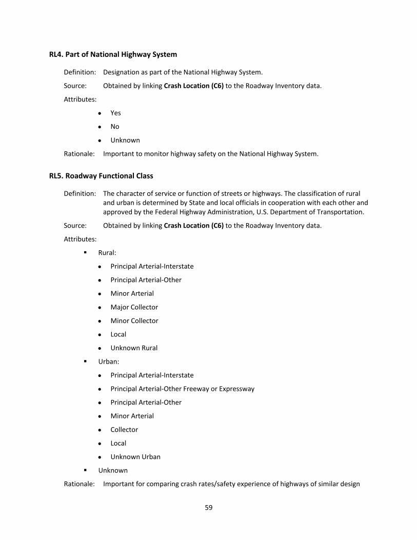
59
RL4. Part of National Highway System
Definition: Designation as part of the National Highway System.
Source: Obtained by linking Crash Location (C6) to the Roadway Inventory data.
Attributes:
• Yes
• No
• Unknown
Rationale: Important to monitor highway safety on the National Highway System.
RL5. Roadway Functional Class
Definition: The character of service or function of streets or highways. The classification of rural and urban is determined by State and local officials in cooperation with each other and approved by the Federal Highway Administration, U.S. Department of Transportation.
Source: Obtained by linking Crash Location (C6) to the Roadway Inventory data.
Attributes:
Rural:
• Principal Arterial-Interstate
• Principal Arterial-Other
• Minor Arterial
• Major Collector
• Minor Collector
• Local
• Unknown Rural
Urban:
• Principal Arterial-Interstate
• Principal Arterial-Other Freeway or Expressway
• Principal Arterial-Other
• Minor Arterial
• Collector
• Local
• Unknown Urban
Unknown
Rationale: Important for comparing crash rates/safety experience of highways of similar design

60
characteristics so as to identify those highways or highway sections that have abnormal rates/experience for future improvements as well as generalized study of the highways in a region or State. Knowledge of the land use is needed in analyzing crashes as part of a network analysis.
RL6. Annual Average Daily Traffic
Definition: The average number of motor vehicles passing a point on a trafficway in a day, for all days of the year, during a specified calendar year.
Source: Obtained by linking Crash Location (C6) to the Roadway Inventory data.
Attributes: Subfield 1:
• AADT Year
Subfield 2:
• AADT
Subfield 3:
• Truck (over 10,000 lbs.) Percentage
Subfield 4:
• Motorcycle Percentage
Rationale: Important to normalize crash data to account for exposure.
RL7. Widths of Lane(s) and Shoulder(s)
Definition: Widths (in feet) of the lane(s) and of the shoulder(s) where crash occurred.
Source: Obtained by linking Crash Location (C6) to the Roadway Inventory data.
Attributes: Subfield 1:
• Lane Width
Subfield 2:
• Right Shoulder Width
Subfield 3:
• Left Shoulder Width
Rationale: Important to monitor the association of lane/shoulder widths and the frequency of crashes.
RL8. Width of Median
Definition: Width from travel lane edge to travel lane edge of the portion of divided highway separating the road for traffic in opposing directions where the crash occurred. If a crash occurs at a mid-block section, the median width is based on the mid-block

61
section. If the crash occurs at an intersection, the median width is based on the median widths at the intersection.
Source: Obtained by linking Crash Location (C6) to the Roadway Inventory data.
Attribute:
• Width of Median
Rationale: Important to monitor the need for medians to protect motorists from oncoming traffic.
RL9. Access Control
Definition: The degree that access to abutting land is fully, partially, or not controlled by a public authority. Full access control provides access only at interchanges (interstate, etc.). Partial access control provides no private access. No access control permits private access (driveway, etc.).
Source: Obtained by linking Crash Location (C6) to the Roadway Inventory data.
Attributes:
• Full Access Control
• Partial access Control
• No Access Control
Rationale: Highly correlated with crash rates and, therefore, useful in identifying high hazard locations. Important to guide future highway design and traffic control.
RL10. Railway Crossing ID
Definition: A unique US DOT/AAR number assigned for identification purposes to a railroad crossing by a state highway agency in cooperation with the Federal Railroad Administration.
Source: Obtained by linking Crash Location (C6) to State or Federal Railway Administration data.
Attribute:
• State specific number assigned by a State in cooperation with the American Association of Railroads.
Rationale: The data are used in high crash locations as well as high-risk corridors. Important for determining the need for additional controls and evaluating the efficacy of various types of controls.

62
RL11. Roadway Lighting
Definition: Type of roadway illumination.
Source: Obtained by linking Crash Location (C6) to the Roadway Inventory data.
Attributes:
• No Lighting
• Spot Illumination on One Side
• Spot Illumination on Both Sides
• Continuous Lighting on One Side
• Continuous Lighting on Both Sides
Rationale: Recognized as having a benefit to safe highway operations. Information about the presence of lighting is an important element in analysis of a spot location, a section of highway, or a network analysis. Important for determining the effects of highway illumination on nighttime crashes to guide future installations.
RL12. Pavement Markings, Longitudinal
Definition: The longitudinal markings (paint, plastic, or other) used on the roadway surface to guide or control the path followed by drivers.
Attributes: Subfield 1:
Edgeline Presence/Type
• No Marked Edgeline
• Standard Width Edgeline
• Wide Edgeline
• Other
Subfield 2:
Centerline Presence/Type
• No Marked Centerline
• Standard Centerline Markings
• Centerline With Centerline Rumble Strip
Subfield 3:
Lane Line Markings
• No Lane Markings
• Standard Lane Line
• Wide Lane Line
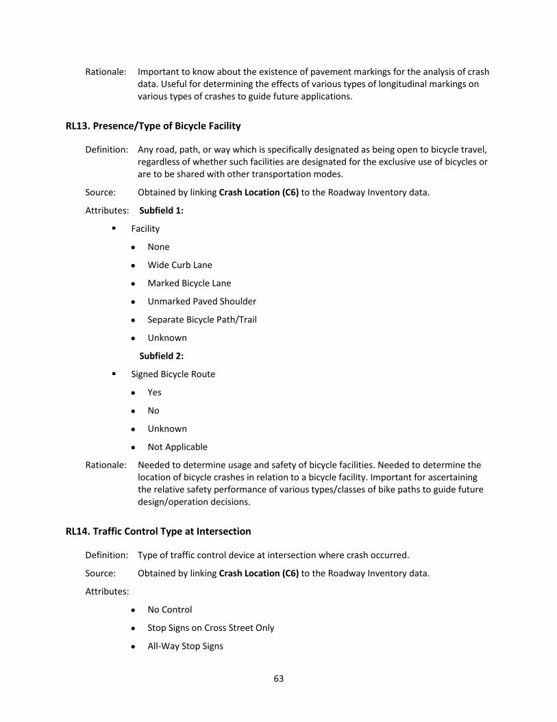
63
Rationale: Important to know about the existence of pavement markings for the analysis of crash data. Useful for determining the effects of various types of longitudinal markings on various types of crashes to guide future applications.
RL13. Presence/Type of Bicycle Facility
Definition: Any road, path, or way which is specifically designated as being open to bicycle travel, regardless of whether such facilities are designated for the exclusive use of bicycles or are to be shared with other transportation modes.
Source: Obtained by linking Crash Location (C6) to the Roadway Inventory data.
Attributes: Subfield 1:
Facility
• None
• Wide Curb Lane
• Marked Bicycle Lane
• Unmarked Paved Shoulder
• Separate Bicycle Path/Trail
• Unknown
Subfield 2:
Signed Bicycle Route
• Yes
• No
• Unknown
• Not Applicable
Rationale: Needed to determine usage and safety of bicycle facilities. Needed to determine the location of bicycle crashes in relation to a bicycle facility. Important for ascertaining the relative safety performance of various types/classes of bike paths to guide future design/operation decisions.
RL14. Traffic Control Type at Intersection
Definition: Type of traffic control device at intersection where crash occurred.
Source: Obtained by linking Crash Location (C6) to the Roadway Inventory data.
Attributes:
• No Control
• Stop Signs on Cross Street Only
• All-Way Stop Signs

64
• All-Way Flasher (red on cross street)
• All-Way Flasher (yellow on main, red on all legs)
• Yield Signs on Cross Street Only
• Signals Pre-Timed (2 Phase)
• Signals Pre-Timed (multi-phase)
• Signals Semi-Actuated (2 Phase)
• Signals Semi-Actuated (multi-phase)
• Signals Fully Actuated (2 Phase)
• Signals Fully Actuated (multi-phase)
• Other
• Unknown
Rationale: Important to understand the relationship between crashes at intersections and the type of traffic control device present.
RL15. Mainline Number of Lanes at Intersection
Definition: Number of through lanes on the mainline approaches of an intersection, including all lanes with through movement (through and left-turn, or through and right-turn) but not exclusive turn lanes.
Source: Obtained by linking Crash Location (C6) to the Roadway Inventory data.
Attributes:
• One Lane
• Two Lanes
• Three Lanes
• Four to Six Lanes
• Seven or More Lanes
• Unknown
Rationale: Important to describe the intersection.
RL16. Cross-Street Number of Lanes at Intersection
Definition: Number of through lanes on the side-road approaches at intersection including all lanes with through movement (through and left-turn, or through and right-turn) but not exclusive turn lanes.
Source: Obtained by linking Crash Location (C6) to the Roadway Inventory data.

65
Attributes:
• One Lane
• Two Lanes
• Three Lanes
• Four to Six Lanes
• Seven or More Lanes
• Unknown
Rationale: Important to describe the intersection.
RL17. Total Volume of Entering Vehicles
Definition: Total entering vehicles for all approaches of an intersection.
Source: Obtained by linking Crash Location (C6) to the Roadway Inventory data.
Attributes: Subfield 1:
• AADT Year
Subfield 2:
• AADT
Rationale: Important to understand volume of crashes as a measure of exposure for the mainline approaches.
66
Glossary
Acronyms
AAMVA American Association of Motor Vehicle Administrators
AAR Association of American Railroads
AASHTO American Association of State Highway and Transportation Officials
ANSI American National Standards Institute
ASCE Association of State and Community Engineers
ATSIP Association of Traffic Safety Information Professionals
FARS Fatality Analysis Reporting System
FHWA Federal Highway Administration
FMCSA Federal Motor Carrier Safety Administration
GHSA Governors Highway Safety Association
HSIS Highway Safety Information System
IACP International Association of Chiefs of Police
IPTM Institute of Police Technology and Management
ITE Institute of Transportation Engineers
MMUCC Model Minimum Uniform Crash Criteria
NASS-CDS National Automotive Sampling System Crashworthiness Data System
NASS-GES National Automotive Sampling System General Estimates System
NCIC National Crime Information Center
NCSA National Center for Statistics and Analysis
NHTSA National Highway Traffic Safety Administration
PDO Property Damage Only
SAE Society of Automotive Engineers
TRCC Traffic Records Coordinating Committee
US DOT United States Department of Transportation

67
MMUCC Data Element Attribute Terminology
Data element definitions are provided in the Data Elements section, pages 1 through 63. In general, ANSI D16.1 Manual on Classification of Motor Vehicle Traffic Accidents provides greater definitional detail than contained in this glossary. Examples and graphic depictions of many MMUCC definition attributes are available on www.mmucc.us. Data Term Element Definition Acceleration / Deceleration Lane
C16 A lane in the roadway that is designated for vehicles to either increase vehicle speed to reach traffic speed, or to reduce speed.
Access Control RL9 The degree that access to abutting land in connection with a highway is fully, partially, or not controlled by public authority.
Activity Area C19 Located adjacent to actual work area, whether workers and equipment were present or not.
Advance Warning Area
C19 Located after the first warning sign but before the work area.
Age PD1 Years of age for the person involved in the crash. Air Bag Deployed P9 Deployment status of an air bag relative to position of the
occupant. Alcohol/Involvement CD7 A flag to indicate that at least one driver or non-motorist involved
in the crash is suspected by law enforcement to have used alcohol.
Alcohol Test P19 Indication of presence of alcohol test, type, and result. Alignment V16
RL2 The geometric characteristics or layout of a roadway. Alignment is usually subdivided into horizontal and vertical alignment. Includes straight, curve left, curve right.
Alphanumeric Identifier
V1, V4 P12
Consisting of alphabetic and numerical symbols.
Angle C9 A crash where two motor vehicles impact at an angle. For example, the front of one motor vehicle impacts the side of another motor vehicle.
Annual Average Daily Traffic
RL6 The average number of motor vehicles passing a point on a roadway in a day, for all days of the year, during a specified calendar year.
Asleep or Fatigued P17 Driver experienced a temporary loss of consciousness or was operating in a reduced physical and mental capacity due to weariness, medication, or other drugs.

68
Data Term Element Definition At Intersection but no Crosswalk
P25 Person at an area that contains a crossing or connection of two or more roadways not classified as a driveway access but without the street crossing distinctly indicated for pedestrian crossing by lines or other markings on the surface of the roadway.
ATV V8 All Terrain Vehicle Auto Transporter V29 Describes a cargo body type that is specifically designed to
transport multiple, fully assembled automobiles. Single-unit flatbed tow-trucks hauling cars DO NOT qualify. Auto transporters are typically configured as truck-trailers.
BAC P19 Blood Alcohol Concentration Backing V18 A start from a parked or stopped position in the direction of the
rear of the motor vehicle. Back-up C15 An accumulation of traffic caused by vehicles slowing or stopping
the traffic flow. Bicycle Facility, Presence/Type of
RL13 Any road, path, or way which is specifically designated as being open to bicycle travel regardless of whether such facilities are designated for the exclusive use of bicycles or are to be shared with other transportation modes.
Bicycle Lane P25 A bikeway adjacent to travel lanes which has been designated for preferential or exclusive use by pedalcyclists through striping, signage or pavement markings.
Bicycle Violation P15 The disregard, intentionally or unintentionally, of the rules or laws governing the operation of a bicycle as a transport device in the location where the violation occurred.
Blowing Sand, Soil Dirt
C11 Earthen particles being blown about by the wind, reducing visibility.
Blowing Snow C11 Wind-driven snow that reduces visibility. Blowing snow can be falling snow or snow that has already accumulated but is picked up and blown by strong winds.
Booster Seat P8 A “belt-positioning seat” that positions a child on a vehicle seat to improve the fit of the child in a lap and shoulder seat belt system.
Bridge C7 V20, V21
A structure, including supports, carrying a roadway, railroad, etc., over an obstruction such as water, a railway, or another roadway, having an opening of 20 feet or more measured along the center of the structure.
Bridge Overhead Structure
C7 V20, V21
Any part of a bridge that is over the reference or subject roadway. In crash reporting, this typically refers to the beams or other structural elements supporting a bridge deck.

69
Data Term Element Definition Bridge – Pier or Support
C7 V20, V21
Support for a bridge structure including the ends (abutments).
Bridge/Structure Identification Number
RL1 A unique federal inspection/inventory identifier assigned to a bridge, underpass, overpass, or tunnel that is also linkable to the national bridge inventory.
Bridge Rail C7 V20, V21
A barrier attached to a bridge deck or a bridge parapet to restrain motor vehicles, pedestrians or other users.
Bus C18, V8 V22, V28 V29, PL1
A motor vehicle with seating for transporting nine or more persons, including the driver.
Cable Barrier C7 V20, V21
Refers to a flexible barrier system which uses several cables typically supported by steel posts. These can be used on the roadside or as a median barrier. These barriers are designed to help lessen impact or keep vehicles within the confines of the road.
Cargo Body Type V29 A description of the vehicle’s primary cargo carrying capacity. Cargo/Equipment Loss or Shift
C7 V20, V21
As a non-collision event in First Harmful Event or Most Harmful Event, the loss or shift would have to cause damage to the motor vehicle or occupants that is transporting the cargo/equipment or the cargo or equipment itself. If cargo/equipment is lost and strikes another vehicle that is a collision event. As a non-collision event in the Sequence of Events, a cargo/equipment loss or shift is not necessarily harmful. For example, the loss or release of the goods being transported from the cargo compartment of the truck, or the shifting off position of the load affecting its balance.
Cargo Loss V19 Is used for a vehicle when its initial harmful event involves striking another vehicle, person, or property (a collision event) by virtue of a load/cargo that falls from or is propelled by the vehicle. For example, “Cargo Loss” would be selected for a log truck if, in the initial harmful event, logs fall from a log truck onto the top of a vehicle in an adjacent lane.
Cargo Tank V29 A single-unit truck, truck/trailer, or tractor semi-trailer having a cargo body designed to transport dry bulk (fly, ash, etc.), liquid bulk (gasoline, milk, etc.) or gas bulk (propane, etc.).
Cargo Van V8 A cargo van is any van where the area behind the driver or cab is designed for transporting cargo or operated for general commercial use.

70
Data Term Element Definition Changing Lanes V18 Shift from one traffic lane to another traffic lane while moving in
the same direction. Charter/Tour V22 A company providing transportation on a for-hire basis and
demand-response basis, usually round-trip service for a tour group or outing.
Child Safety Seat Used
P8 Child passenger seated in a forward or rear facing child safety seat. This does not imply correct use or placement of the seat.
Collision Event C9 Harmful events that involve the collision of a motor vehicle in transport with another motor vehicle, other property, animal or pedestrian.
Collision with Fixed Object
C7 V20, V21
A motor vehicle in transport strikes a an impact attenuator/crash cushion, bridge overhead structure, bridge pier or support, bridge rail, culvert, curb, ditch, embankment, guardrail face or end, concrete traffic barrier, standing tree, utility pole/light support, traffic sign or signal support, fence, mailbox, or other fixed object.
Collision with Person, Motor Vehicle, or Non-Fixed Object
C7 V20, V21
A motor vehicle in transport strikes a pedestrian, pedal cycle, railway vehicle, animal, motor vehicle in transport, parked motor vehicle, struck by falling, shifting cargo or anything set in motion by motor vehicle, work zone/maintenance equipment, or other moveable object.
Commercial Driver License Class (CDLC)
P12 The type of commercial motor vehicle that a licensed driver has been examined on and/or approved to operate. This information is obtained by linkage to the driver license file.
Commercial Motor Vehicle
V28 PL2
A commercial motor vehicle is any motor vehicle used for the transportation of goods, property or people in interstate or intrastate commerce.
Concrete Traffic Barrier
C7 V20, V21
Refers to the longitudinal traffic barriers constructed of concrete and located on the outside of the road surface, in a median, or in gore areas. This includes all temporary concrete barriers regardless of location (i.e., temporary barrier on a bridge being used to control traffic during bridge repair/construction).
Construction Zone C19 See Work Zone. Crash Cushion C7
V20, V21 See Impact Attenuator.

71
Data Term Element Definition Cross Median/Centerline
V20 Is used when a vehicle completely crosses the median and enters the shoulder or travel lanes on the opposite side of a divided highway. It also includes crossing over the center line of a two-way, undivided highway. This also includes unstabilized situations involving vehicles completely crossing over a continuous left-turn lane.
Crossover C16 Area in the median of a divided trafficway where motor vehicles are permitted to travel cross the opposing lanes of traffic or do a U-turn.
Crossover-related C16 A crash on approach to or exit from a crossover related to the movement of traffic units through the crossover.
Culvert C7 V20, V21
An enclosed structure providing free passage of water under a roadway with a clear opening of less than twenty feet measured along the center of the roadway.
Curb C7 V20, V21
A raised edge or border to a roadway. Curbs may be constructed of concrete, asphalt or wood typically have a face height of less than 9 inches.
Dark – Lighted C12 The scene of the crash is illuminated at night, or another period of darkness, by street lamps or other man-made light sources.
Dark – Not Lighted C12 The scene of the crash is not illuminated at night, or another period of darkness, by street lamps or other man-made light sources.
Dark – Unknown if Lighted
C12 It is known that the crash occurred at night or during another period of darkness, but it is not known if the crash scene was illuminated by a man-made light source.
Dart/Dash P24 Non-motorist entering from off the roadway, including running, jogging, or stumbling, etc.
Dawn C12 The time that marks the beginning of the twilight before sunrise. Daylight C12 Whenever the sun is above the horizon at a given location. Debris C15 Object(s) in the roadway that may have contributed to the crash,
such as cardboard boxes, trash, or vehicle parts or other materials that have fallen from another vehicle.
Deployed Air Bag – Combination
P9 More than one air bag deploys, including front driver and front passenger, front and side, or front, side and other, etc. Refer to Appendix M.
Deployed Air Bag – Front
P9 Driver or front seat passenger air bag is out of its cover and protruding into driver compartment. Bag is fully or partially deflated or inflated. Refer to Appendix M.

72
Data Term Element Definition Deployed Air Bag – Curtain
P9 Curtain air bag is out of its cover and protruding into driver or passenger compartment. Bag is fully or partially deflated or inflated. Refer to Appendix M.
Deployed Air Bag – Side
P9 Air bag on side of motor vehicle is out of its cover and protruding into occupant compartment. Bag is fully or partially deflated or inflated. Refer to Appendix M.
Deployed Air Bag – Other
P9 A knee air bag, air belt, or other new air bag technology is deployed. Refer to Appendix M.
Deployment Unknown
P9 Not known if air bag is out of its cover and protruding into occupant compartment.
Disabling Damage V19, V24 Damage that precludes departure of the motor vehicle from the scene of the crash in its usual daylight-operating manner after simple repairs. As a result, the motor vehicle had to be towed, or carried from crash scene, or assisted by an emergency motor vehicle.
Divided Highway V14 Roadway travel in opposite directions that is physically separated by a median that is painted, raised, suppressed, etc. Excludes 2-way continuous left turn lanes.
DOT-Compliant Motorcycle Helmet
P8 Motorcycle helmets that are compliant with Federal Motor Vehicle Safety Standards typically weigh approximately 3 pounds, have an inner liner at least one-inch thick of firm polystyrene foam, have an inside label that states the manufacturer, model, and date of manufacture, and have a DOT sticker on the back of the helmet. A DOT sticker alone is not sufficient evidence to indicate that the helmet is DOT-compliant, as counterfeit stickers have been found affixed to non-compliant helmets.
Driver P4 An occupant who is in actual physical control of a motor vehicle or, for an out- of-control motor vehicle, an occupant who was in control until control was lost.
Driveway C16 A driveway is a private way which provides vehicular access to the public from a trafficway to property, parking, or loading areas outside the boundaries of the trafficway, but is considered to be not open to the public for transportation purposes as a trafficway. A driveway is outside the trafficway and is typically not provided an official identification name or number.
73
Data Term Element Definition Driveway Access Related
C16 A traffic accident that (l) occurs adjacent to a driveway, (2) is not a driveway access accident, and (3) results from an activity, behavior, or control related to the movement of traffic units onto or out of a driveway.
Drug Involvement CD8 A flag indicating that at least one driver or non-motorist involved in the crash was suspected by law enforcement to have used drugs.
Dump V29 A cargo body type that can be tilted or otherwise manipulated to discharge its load by gravity.
Electronic Communication Device
P16 Includes cell phone, smart phone, pager, 2-way radio and other devices enabling the driver and/or occupants of the vehicle to communicate with others not located in the vehicle.
Embankment C7 V20, V21
Earthen structure used to support a channel or roadway.
Emergency Operation, Emergency Equipment in Use
V11 The authorized emergency vehicle has been dispatched to an incident or has initiated an emergency operation and is using an audible siren and/or has illuminated its emergency lighting devices. The emergency vehicle operator is using or is prepared to use emergency vehicle maneuvers as allowed by state law.
Emergency Operation, Emergency Equipment not in Use
V11 The authorized emergency vehicle has been dispatched to an incident or has initiated an emergency operation and has no emergency lighting or audible siren in use. The emergency vehicle operator may be using emergency vehicle maneuvers as allowed under state law. Examples: a police car in the last mile approaching a bank robbery; transport of a patient in an ambulance for which lights and sirens are not used per protocol.
EMS Response Agency Identifier
P28 Identifier for EMS agency that responds to the crash.
EMS Response Run Number
P28 Usually documented on EMS Run Report
Endorsements P12 Issued to drivers after successfully completing a specialized test that qualifies them to operate that specific type of vehicle.
Entrance/Exit Ramp C16 Crash occurs on an approach to or exit from a roadway or results from an activity, behavior or control related to the movement of traffic units entering or exiting a ramp.

74
Data Term Element Definition Exceeded Speed Limit P13 When a motor vehicle is traveling above the posted/statutory
speed limit on certain designated roadways and/or by certain types of vehicles; e.g., for trucks, buses, motorcycles, on bridge, at night, in school zone, etc.).
Extent of Damage V19 Estimation of total damage to the motor vehicle caused by the crash. Disabling damage implies damage to the motor vehicle that is sufficient to require the motor vehicle to be towed or carried from the scene.
External Distraction P16 Driver distractions that occur outside the vehicle, such as a crash in the next lane or on the other side of the median, automated highway signs, interesting objects in the sky, fire off the roadway, etc.
Failure to Keep in Proper Lane
P14 Driver did not maintain position in appropriate travel lane.
Failed to Yield Right-of-Way
P14 Driver failed to yield right-of-way to another motor vehicle or non-occupant as required.
Farm Waiver PL1 Waiver granted for the operation of farm motor vehicles. Fatal Injury (K) P5
CD1 A fatal injury is any injury that results in death within 30 days after the motor vehicle crash in which the injury occurred. If the person did not die at the scene but died within 30 days of the motor vehicle crash in which the injury occurred, the injury classification should be changed from the attribute previously assigned to the attribute “Fatal Injury.”
Fell/Jumped from Motor Vehicle
C7 V20, V21
Motor vehicle occupant either involuntarily fell or intentionally leapt from the vehicle.
FIPS Code C4, C5 Federal Information Processing Standards for coding states, counties, and cities, which can be accessed on the Internet at www.gsa.gov.
Fire/Explosion C7 V20, V21
A fire or explosion that was the cause or result of the crash. A fire/explosion is a non- collision harmful event.
Flagger V17 A traffic control person controlling traffic with a flag applicable to the motor vehicle at the crash location.
Flashing Traffic Control Signal
V17 A traffic control signal that is flashing or a single light flashing red or yellow.
Flatbed V29 A single-unit truck, truck/trailer, or tractor/semi-trailer whose body is without sides or roof, with or without readily removable stakes which may be tied together with chains, slats, or panels. This includes trucks transporting containerized loads.
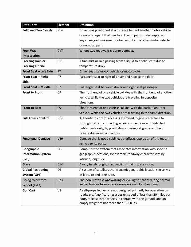
75
Data Term Element Definition Followed Too Closely P14 Driver was positioned at a distance behind another motor vehicle
or non- occupant that was too close to permit safe response to any change in movement or behavior by the other motor vehicle or non-occupant.
Four-Way Intersection
C17 Where two roadways cross or connect.
Freezing Rain or Freezing Drizzle
C11 A fine mist or rain passing from a liquid to a solid state due to temperature drop.
Front Seat – Left Side P7 Driver seat for motor vehicle or motorcycle. Front Seat – Right Side
P7 Passenger seat to right of driver and next to the door.
Front Seat – Middle P7 Passenger seat between driver and right seat passenger Front to Front C9 The front end of one vehicle collides with the front end of another
vehicle, while the two vehicles are traveling in opposite directions.
Front to Rear C9 The front end of one vehicle collides with the back of another vehicle, while the two vehicles are traveling in the same direction.
Full Access Control RL9 Authority to control access is exercised to give preference to through traffic by providing access connections with selected public roads only, by prohibiting crossings at grade or direct private driveway connections.
Functional Damage V19 Damage that is not disabling, but affects operation of the motor vehicle or its parts.
Geographic Information System (GIS)
C6 Computerized system that associates information with specific geographic locations, for example roadway characteristics by latitude/longitude.
Glare C14 A very harsh, bright, dazzling light that impairs vision. Global Positioning System (GPS)
C6 A system of satellites that transmit geographic locations in terms of latitude and longitude.
Going to or from School (K-12)
P23 The non-motorist was walking or cycling to school during normal arrival time or from school during normal dismissal time.
Golf Cart V8 A self-propelled vehicle not designed primarily for operation on roadways. A golf cart has a design speed of less than 20 miles per hour, at least three wheels in contact with the ground, and an empty weight of not more than 1,300 lbs.

76
Data Term Element Definition Gore C8 An area of land where two roadways diverge or converge. The
area is bounded on two sides by the edges of the roadways, which join at the point of divergence or convergence. The direction of traffic must be the same on both sides of these roadways. The area includes shoulders or marked pavement, if any, between the roadways.
Grade V16 The inclination of a roadway, expressed in the rate of rise or fall in feet (meters) per 100 feet (meters) of horizontal distance. Includes level, hillcrest, uphill, downhill, sag (bottom).
Grain/Chips/Gravel Truck
V29 Describes a cargo body type used for hauling these or other similar bulk commodities. They may be referred to as “open hoppers” or “belly dumps.”
Gross Combination Weight Rating (GCWR)
V27 The value specified by the manufacturer(s) as the recommended maximum loaded weight of a combination (articulated) motor vehicle. This is for truck tractors and single-unit trucks pulling a trailer(s). GCWR is the sum of the gross vehicle weight ratings (GVWR) of all units, power unit and its trailer(s).
Gross Vehicle Weight Rating (GVWR)
V27 The value specified by the manufacturer as the recommended maximum loaded weight of a single motor vehicle. This rating includes the maximum rated capacity of a vehicle, including the base vehicle, mounted equipment and any cargo and passengers. Most of the time, the GVWR is the sum of the maximum rated capacity of the axles of the vehicle.
Guardrail C7 V20, V21
A longitudinal barrier consisting of posts and rails.
Guardrail End C7 V20, V21
The end of the guardrail.
Guardrail Face C7 V20, V21
Surface area of the guardrail other than the end.
Harmful Event C7 V20, V21
Occurrence of injury or damage.
Hazardous Materials V30 Any substance or material which has been determined by the U.S. Secretary of Transportation to be capable of posing an unreasonable risk to health, safety, and property when transported in commerce and which has been so designed under regulations of the US DOT.

77
Data Term Element Definition Hazardous Materials Placard
V30 A Hazardous Materials Placard is a sign required to be affixed to any motor vehicle transporting quantities of hazardous materials in quantities above the thresholds established by the U.S. Department of Transportation, or other authorized entity. This placard identifies the hazard class division number, 4-digit hazardous material identification number or name of the hazardous material being transported.
Helmet, Other than DOT-Compliant Motorcycle Helmet
P8 A helmet that is not a DOT-compliant motorcycle helmet. This includes bicycle helmets, skateboard helmets, and novelty helmets. Motorcycle helmets that are compliant with Federal Motor Vehicle Safety Standards typically weigh approximately 3 pounds, have an inner liner at least one-inch thick of firm polystyrene foam, have an inside label that states the manufacturer, model, and date of manufacture, and have a DOT sticker on the back of the helmet. A DOT sticker alone is not sufficient evidence to indicate that the helmet is DOT-compliant, as counterfeit stickers have been found affixed to non-compliant helmets.
Helmet, Unknown if DOT-Compliant Motorcycle Helmet
P8 A helmet was worn by the motorcycle rider, but the investigating officer cannot determine if it is a DOT-compliant motorcycle helmet.
Helmet Used P26 Safety helmet worn by non-motorist (bicyclist, skateboarder, etc.).
Highway Traffic Sign C7 V20, V21
A sign intended to guide, regulate, or inform highway users.
Highway Traffic Post C7 V20, V21
A pole, post, or structure constructed to support a highway sign.
Hillcrest V16 The top of a hill. Horizontal Alignment RL2 The change in horizontal direction of a roadway determined at
the point of curvature (pc) and expressed in terms of direction, degree of curve and length.
ICD-9, ICD-10 PL4, PL5 International Classification of Diseases, 9th edition, and 10th edition in process, developed by the World Health Organization and maintained in the U.S. by the Centers of Disease Control, DHHS. This system codes the type of disease/injury and body area affected for all hospital inpatients that are discharged and to document the cause of death.

78
Data Term Element Definition Identification Number
V1, V3, V4 V26, RL1
A unique number that identifies a person, crash, motor vehicle, bridge/structure, etc.
Immersion, Full or Partial
C7 V20, V21
Entry of a vehicle into liquid so that it is completely covered or there is damage to the vehicle or harm to an occupant.
Impact Attenuator/Crash Cushion
C7 V20, V21
A barrier at a spot location, less than 25 ft. (7.6 m) away, designed to prevent an errant motor vehicle from impacting a fixed object hazard by gradually decelerating the motor vehicle to a safe stop or by redirecting the motor vehicle away from the hazard.
Incident Response V10 Government vehicles typically equipped with a variety of tools, emergency medical equipment, traffic cones and control signs, absorbent material (for responding to spills), emergency and work lighting. These multi-purpose response units are intended to assist law enforcement, fire and rescue personnel with trafficway incident management.
In Parking Lane or Zone
C8 Crash location outside the roadway in a space designated for parking motor vehicles.
In Roadway – Other P23 Non-motorist in roadway, such as a child playing or a mechanic working on a motor vehicle.
In Transport Multiple The term “in-transport” denotes the state or condition of a transport vehicle which is in motion or within the portion of a transport way ordinarily used by similar transport vehicles. When applied to motor vehicles, “in-transport” means on a roadway or in motion within or outside the trafficway. A transport vehicle which is also a working motor vehicle at the time of the unstabilized situation is not “in-transport.” In roadway lanes used for travel during some periods and for parking during other periods, a parked motor vehicle should be considered to be in-transport during periods when parking is forbidden.
Indian Nation P10 A federally recognized Indian tribe with sovereign authority to interact on a government-to-government basis directly with federal agencies.
Interchange C16 A system of interconnecting roadways in conjunction with one or more grade separations, providing for the movement of traffic between two or more roadways on different levels.
Intercity V22 A company providing for-hire, long-distance passenger transportation between cities over fixed routes with regular schedules (for example, Greyhound bus service between major cities).

79
Data Term Element Definition Intermediate License Restrictions
PL1 The Intermediate License is the second stage of obtaining a full license privilege under most Graduated Driver’s License (GDL) programs. It is typically for drivers between the ages of 16 and 17, and does not require total supervision during daylight hours (e.g., adult supervision during the hours of midnight to 5 am). An Intermediate Driver License may be suspended or revoked under certain violations. Other conditions may include conviction-free performance, seat-belt use for occupants, and some age restrictions for passengers. If any restriction is violated, this GDL restriction period can be extended.
Intermittent or Moving Work
C19 Type of work zone designating temporary activity that may move or shift frequently.
International License (other than Mexico or Canada)
P11 Driver license issued by country other than Canada, Mexico or U.S.
Intersection C16, C17 An area which 1) contains a crossing or connection of two or more roadways not classified as driveway access and 2) is embraced within the prolongation of the lateral curb lines, or, if none, the lateral boundary lines of the roadways. Where the distance along a roadway between two areas meeting these criteria is less than 33 feet, the two areas and the roadway connecting them are considered to be parts of a single intersection.
Intersection as Part of Interchange
C17 Refer to Appendices G and H.
Intersection Related C16 A traffic accident in which the first harmful event (1) occurs on an approach to or exit from an intersection and (2) results from an activity, behavior or control related to the movement of traffic units through the intersection.
Interstate Carrier V26 A commercial vehicle in the United States where the transit between the points of origin and termination does not occur entirely with the borders of the state of origin. A motor carrier that has authority to operate across state lines. Interstate operators are required to have a USDOT Number by the Federal Motor Carrier Administration.

80
Data Term Element Definition Intrastate Carrier V26 A motor carrier that operates entirely within the state and does
not have the authority to engage in interstate commerce. Intrastate operators are not required to have a USDOT Number by the Federal Motor Carrier Safety Administration; however, some states do require that certain intrastate operators secure a USDOT Number.
Island P25 A cement or grassy area in the middle of a trafficway. Jackknife C7
V20, V21 An uncontrolled articulation between a tractor and trailer(s) that occurs at any time during the crash sequence.
KABCO P5 CD1
A functional measure of the injury severity for any person involved in the crash. K-Fatal Injury, A-Suspected Serious Injury, B-Suspected Minor Injury, C-Possible Injury, and O-No Apparent Injury.
L-Intersection C16 This is a two-armed intersection in which one road intersects with another road but neither road extends beyond the other road.
Lane V14 A strip of roadway used for single line of motor vehicles. Lane Closure C19 A type of work zone. Lane Line V14 A pavement marking used to separate traffic traveling in the same
direction. Lane lines are normally 4 to 6 inches wide. Lane Shift/Crossover C19 A type of work zone. Lap Belt Only Used P8 Use of a lap safety belt either because the motor vehicle is
equipped only with lap belt or because the shoulder belt is not in use.
Law Enforcement Reporting Agency Identifier
C10 A unique identifier for the law enforcement agency that provided information on the crash report.
Learner’s Permit Restrictions
PL1 The Learner’s Permit is the first stage of obtaining a full license privilege under most Graduated Driver’s License (GDL) programs. It is typically for drivers between 14 and 16 years of age, and typically requires total adult supervision, seat-belt use for occupants, and conviction-free performance. If any restriction is violated, this GDL restriction period can be extended.
Leaving Travel Lane V18 A motor vehicle moving outside the travel lane. Light Support C7
V20, V21 A pole or post constructed to support lighting for the highway.
Light Truck V8, V28 Trucks (van, mini-van, panel, pickup, sport utility) of 10,000 lbs GVWR or less.

81
Data Term Element Definition Lighting P26 Non-motorist use of lights on his/her person or on a motor
vehicle not in transport or transport vehicles other than motor vehicle as safety equipment
Linear Referencing System (LRS)
C6 A standardized data format that provides the ability to create complex overlays of multiple events or occurrences along a route to support corridor planning, pavement rehabilitation, or other complex analysis.
Link Node System C6 A system that assigns an identifier to each segment of roadway and to specific points or nodes that are useful to reference the location of a crash.
Low Speed Vehicle V8 A low speed vehicle (LSV) is a motor vehicle with four or more wheels whose top speed is greater than 20 miles per hour, but not greater than 25 miles per hour. LSVs are required to be equipped with basic items of safety equipment: headlamps, stop lamps, turn signal lamps, tail lamps, reflex reflectors, parking brake, windshields of either type AS-1 or type AS-5 glazing, rearview mirrors, seat belts and vehicle identification numbers (VINs).
Mainline Number of Lanes at Intersection
RL15 Number of “thru” lanes on the mainline approaches at intersection including all lanes with “thru” movement (“thru” and left-turn, or “thru” and right-turn) but not exclusive turn lanes.
Maintenance Zone C19 Refer to Work Zone. Manually Operating an Electronic Communication Device
P16 The driver was in the act of manually manipulating an electronic communication device (cell phone, smart phone, hand-held radio, etc.). The types of device manipulation include dialing, texting, and typing.
Marked Crosswalk P25 That portion of the roadway that is distinctly indicated for pedestrian crossing by lines or other markings on the surface of the roadway.
Median C8 An area of trafficway between parallel roads separating travel in opposite directions. A median should be four or more feet wide.
Medical Facility P28 The hospital, clinic, or trauma center that received the patient for treatment.
Medium/Heavy Truck V8 A truck with a GVWR greater than 10,000 pounds. Minor Damage V19 Damage that does not affect the operation of or disable the
motor vehicle in transport.
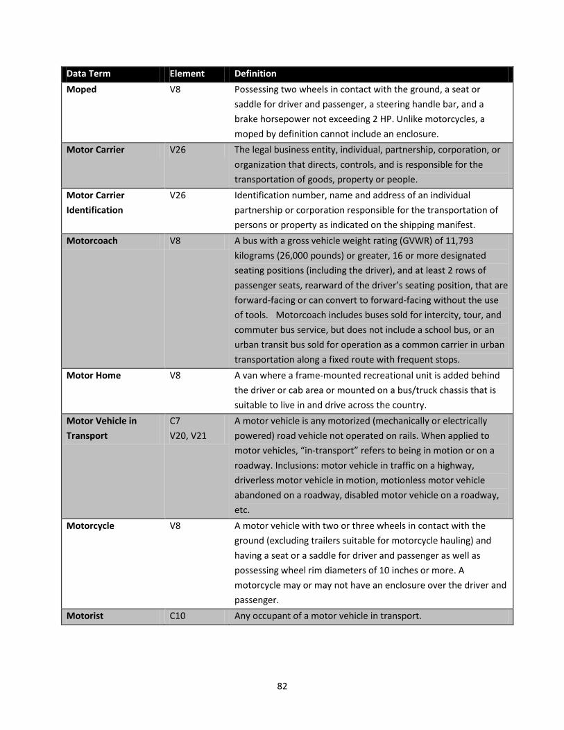
82
Data Term Element Definition Moped V8 Possessing two wheels in contact with the ground, a seat or
saddle for driver and passenger, a steering handle bar, and a brake horsepower not exceeding 2 HP. Unlike motorcycles, a moped by definition cannot include an enclosure.
Motor Carrier V26 The legal business entity, individual, partnership, corporation, or organization that directs, controls, and is responsible for the transportation of goods, property or people.
Motor Carrier Identification
V26 Identification number, name and address of an individual partnership or corporation responsible for the transportation of persons or property as indicated on the shipping manifest.
Motorcoach V8 A bus with a gross vehicle weight rating (GVWR) of 11,793 kilograms (26,000 pounds) or greater, 16 or more designated seating positions (including the driver), and at least 2 rows of passenger seats, rearward of the driver’s seating position, that are forward-facing or can convert to forward-facing without the use of tools. Motorcoach includes buses sold for intercity, tour, and commuter bus service, but does not include a school bus, or an urban transit bus sold for operation as a common carrier in urban transportation along a fixed route with frequent stops.
Motor Home V8 A van where a frame-mounted recreational unit is added behind the driver or cab area or mounted on a bus/truck chassis that is suitable to live in and drive across the country.
Motor Vehicle in Transport
C7 V20, V21
A motor vehicle is any motorized (mechanically or electrically powered) road vehicle not operated on rails. When applied to motor vehicles, “in-transport” refers to being in motion or on a roadway. Inclusions: motor vehicle in traffic on a highway, driverless motor vehicle in motion, motionless motor vehicle abandoned on a roadway, disabled motor vehicle on a roadway, etc.
Motorcycle V8 A motor vehicle with two or three wheels in contact with the ground (excluding trailers suitable for motorcycle hauling) and having a seat or a saddle for driver and passenger as well as possessing wheel rim diameters of 10 inches or more. A motorcycle may or may not have an enclosure over the driver and passenger.
Motorist C10 Any occupant of a motor vehicle in transport.

83
Data Term Element Definition National Highway System
RL4 Includes 160,000 miles of major highways that link most of the U.S. These highways include interstates, principal arterials, strategic highway networks, major strategic highway network connectors, and intermodal connectors.
No Access Control RL9 Includes all sections that do not meet the criteria for full or partial access control.
No Apparent Injury (O)
P5 CD1
No apparent injury is a situation where there is no reason to believe that the person received any bodily harm from the motor vehicle crash. There is no physical evidence of injury and the person does not report any change in normal function.
Non-Collision Event Multiple Any motor vehicle crash event not involving a collision. Includes overturn/rollover, fire/explosion, immersion, jackknife, cargo/equipment loss or shift, equipment failure, separation of units, ran off road right or left, cross median, cross centerline, downhill runaway, fell/jumped from motor vehicle, thrown or falling object.
Non-Emergency, Non-Transport
V10, V11 The authorized emergency vehicle has been dispatched to an incident or has initiated operation in a non-emergency mode and is not transporting passengers, such as patients or suspects. The emergency vehicle operator is not using emergency lighting, audible siren or emergency vehicle maneuvers.
Non-Emergency Transport
V11 The authorized emergency vehicle has been dispatched to an incident or has initiated a transport-related operation in a non-emergency mode. The emergency vehicle operator is not using emergency lighting, audible siren or emergency vehicle maneuvers. Example: transport of a suspect from one location to another or interfacility transport of a patient in an ambulance to a nursing home.
Non-Highway Work C15 Maintenance or other types of work occurring near or in the trafficway but not related to the trafficway.
Non-Junction C16 Roadway that is not an intersection or a connection between a driveway access and a roadway other than a driveway access.
Non-Motorist P4 Any person other than an occupant of a motor vehicle in transport. This includes pedestrians, bicyclists, other cyclists, occupants of other motor vehicles not in transport and occupants of transport vehicles other than motor vehicles.
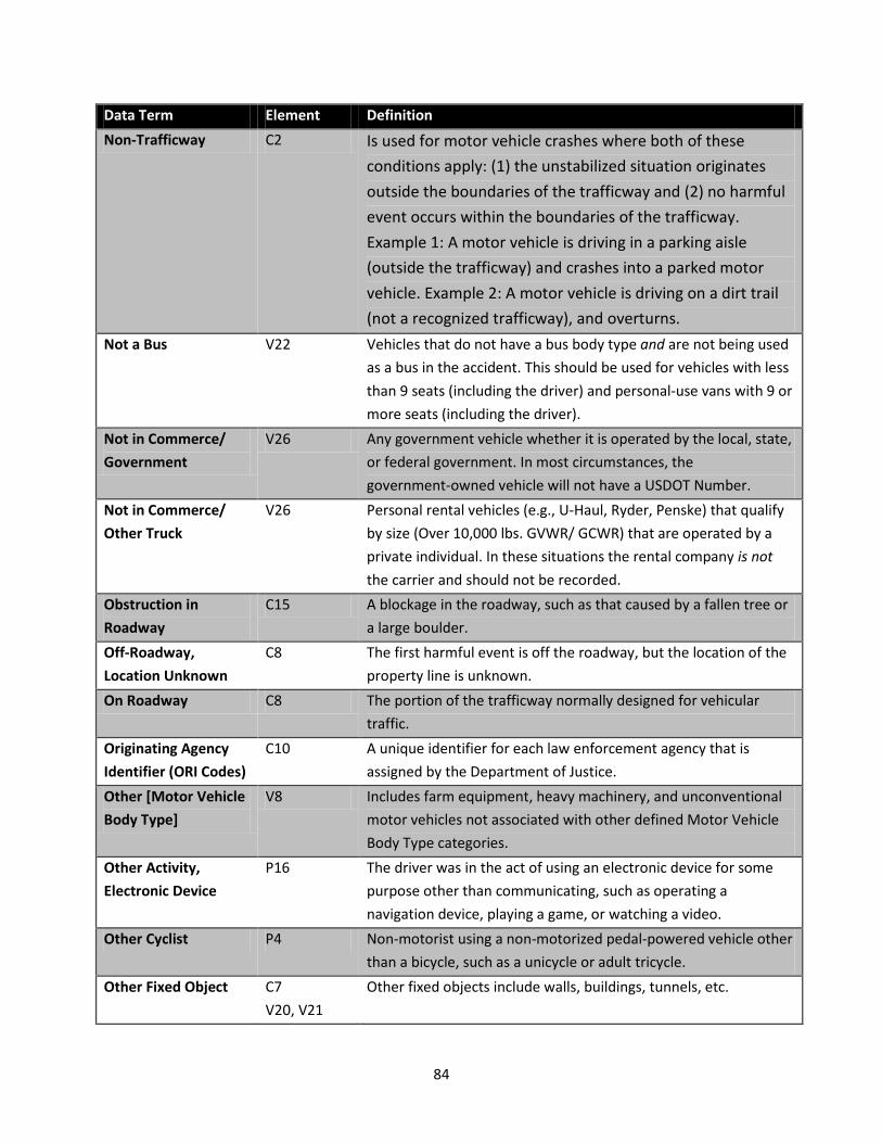
84
Data Term Element Definition Non-Trafficway C2 Is used for motor vehicle crashes where both of these
conditions apply: (1) the unstabilized situation originates outside the boundaries of the trafficway and (2) no harmful event occurs within the boundaries of the trafficway. Example 1: A motor vehicle is driving in a parking aisle (outside the trafficway) and crashes into a parked motor vehicle. Example 2: A motor vehicle is driving on a dirt trail (not a recognized trafficway), and overturns.
Not a Bus V22 Vehicles that do not have a bus body type and are not being used as a bus in the accident. This should be used for vehicles with less than 9 seats (including the driver) and personal-use vans with 9 or more seats (including the driver).
Not in Commerce/ Government
V26 Any government vehicle whether it is operated by the local, state, or federal government. In most circumstances, the government-owned vehicle will not have a USDOT Number.
Not in Commerce/ Other Truck
V26 Personal rental vehicles (e.g., U-Haul, Ryder, Penske) that qualify by size (Over 10,000 lbs. GVWR/ GCWR) that are operated by a private individual. In these situations the rental company is not the carrier and should not be recorded.
Obstruction in Roadway
C15 A blockage in the roadway, such as that caused by a fallen tree or a large boulder.
Off-Roadway, Location Unknown
C8 The first harmful event is off the roadway, but the location of the property line is unknown.
On Roadway C8 The portion of the trafficway normally designed for vehicular traffic.
Originating Agency Identifier (ORI Codes)
C10 A unique identifier for each law enforcement agency that is assigned by the Department of Justice.
Other [Motor Vehicle Body Type]
V8 Includes farm equipment, heavy machinery, and unconventional motor vehicles not associated with other defined Motor Vehicle Body Type categories.
Other Activity, Electronic Device
P16 The driver was in the act of using an electronic device for some purpose other than communicating, such as operating a navigation device, playing a game, or watching a video.
Other Cyclist P4 Non-motorist using a non-motorized pedal-powered vehicle other than a bicycle, such as a unicycle or adult tricycle.
Other Fixed Object C7 V20, V21
Other fixed objects include walls, buildings, tunnels, etc.
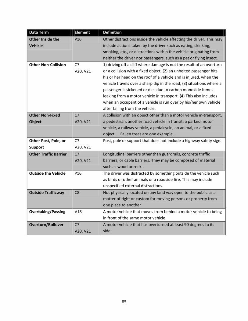
85
Data Term Element Definition Other Inside the Vehicle
P16 Other distractions inside the vehicle affecting the driver. This may include actions taken by the driver such as eating, drinking, smoking, etc., or distractions within the vehicle originating from neither the driver nor passengers, such as a pet or flying insect.
Other Non-Collision C7 V20, V21
1) driving off a cliff where damage is not the result of an overturn or a collision with a fixed object, (2) an unbelted passenger hits his or her head on the roof of a vehicle and is injured, when the vehicle travels over a sharp dip in the road, (3) situations where a passenger is sickened or dies due to carbon monoxide fumes leaking from a motor vehicle in transport. (4) This also includes when an occupant of a vehicle is run over by his/her own vehicle after falling from the vehicle.
Other Non-Fixed Object
C7 V20, V21
A collision with an object other than a motor vehicle in-transport, a pedestrian, another road vehicle in transit, a parked motor vehicle, a railway vehicle, a pedalcycle, an animal, or a fixed object. Fallen trees are one example.
Other Post, Pole, or Support
C7 V20, V21
Post, pole or support that does not include a highway safety sign.
Other Traffic Barrier C7 V20, V21
Longitudinal barriers other than guardrails, concrete traffic barriers, or cable barriers. They may be composed of material such as wood or rock.
Outside the Vehicle P16 The driver was distracted by something outside the vehicle such as birds or other animals or a roadside fire. This may include unspecified external distractions.
Outside Trafficway C8 Not physically located on any land way open to the public as a matter of right or custom for moving persons or property from one place to another
Overtaking/Passing V18 A motor vehicle that moves from behind a motor vehicle to being in front of the same motor vehicle.
Overturn/Rollover C7 V20, V21
A motor vehicle that has overturned at least 90 degrees to its side.

86
Data Term Element Definition Parked Motor Vehicle C7, V2
V20, V21 A parked motor vehicle is a motor vehicle not in-transport, other than a working motor vehicle, that is not in motion and not located on the roadway. In roadway lanes used for travel during some periods and for parking during other periods, a parked motor vehicle should be considered to be in-transport during periods when parking is forbidden. Any stopped motor vehicle where the entirety of the vehicle’s primary outline as defined by the four sides of the vehicle (e.g., tires, bumpers, fenders) and load, if any, is not within the roadway is parked.
Parking Lane C8 An auxiliary lane primarily intended for the parking of motor vehicles.
Partial Access Control RL9 Authority to control access is exercised to give preference to through traffic to a degree that, in addition to access connections with selected public roads, there may be some crossings at grade and some private driveway connections. However, these direct private driveway connections have been minimized through the use of frontage roads or other local access restrictions.
Partially Ejected P10 The occupant’s body was not completely thrown from the motor vehicle as a result of the impact.
Passenger P4, P16 Occupant of motor vehicle other than the driver. In regard to driver distraction, a passenger can be the source of distraction affecting the driver.
Passenger Car/Vehicle
V8 Motor vehicles used primarily for carrying passengers.
Pedalcycle C7 V20, V21
Includes bicycles, tricycles, unicycles, pedal cars, etc.
Pedalcyclist P4 Any rider of a pedalcycle. Pedestrian C7
V20, V21 P4
A person who is not an occupant of a motor vehicle in transport or a pedalcyclist. Includes a person who is adjacent to the motor vehicle regardless of their actions.
Personal Conveyance P4 A personal conveyance is a device, other than a transport device, used by a pedestrian for personal mobility assistance or recreation. These devices can be motorized or human powered, but not propelled by pedaling.
Person [Traffic Control Device]
V17 Includes flaggers, law enforcement personnel, crossing guards, etc.
Physically Impaired P17 A condition that results in some decrease in a physical ability.

87
Data Term Element Definition Placard Number V30 A number included on the hazardous material placard displayed
on trucks that are carrying hazardous materials. Many placards have two numbers, a four-digit number in the middle, and a one-digit number at the bottom. See Appendix K.
Pole Trailer V29 A trailer designed to be attached to the towing vehicle by means of a reach or pole, or by being boomed or otherwise secured to the towing motor vehicle, and ordinarily used for carrying property of a long or irregular shape.
Police V10 A vehicle equipped with police emergency devices (lights and siren) that is owned or subsidized by any local, county, State or Federal government entity. The police vehicle is presumed to be in special use at all times, although not necessarily in “emergency use.” Vehicles not owned by a government entity that are used by law enforcement officers (e.g., undercover) are excluded.
Possible Injury (C) P5 CD1
A possible injury is any injury reported or claimed which is not a fatal, suspected serious or suspected minor injury. Examples include momentary loss of consciousness, claim of injury, limping, or complaint of pain or nausea. Possible injuries are those which are reported by the person or are indicated by his/her behavior, but no wounds or injuries are readily evident.
Private Property C2 Is used for a crash that occurs and is entirely contained within a location that is not owned by the public. Do not use this selection for crashes that originate on private property where a harmful event occurs on public property. That circumstance should be classified as “public property.” For example, a crash where a driver loses control of their vehicle backing from their private driveway and impacts a vehicle on the roadway should be classified as “public property.”
Property Damage Only (PDO)
CD1 A crash that results in damage to the motor vehicle or other property, but without injury to any occupants or non-motorists.
Protective Pads Used P26 Padded, shaped attachments were used by the non-motorist to protect specific areas of the body (elbows, knees, shins, etc.).
Public Property C2 Is used for any crash that occurs and is entirely contained within a location that is owned by the public. Also use this attribute for crashes that originate on a location that is owned by the public where a harmful event occurs on private property. For example, a vehicle that departs the roadway and impacts a tree in a citizen’s front yard should be classified as “public property.”

88
Data Term Element Definition Racing P13 When two or more motor vehicles are engaged in a speed-related
competition on the trafficway. Railway Crossing Device
V17 Any sign, signal, or gate that warns of on-coming trains or train tracks crossing the roadway.
Railway Grade Crossing
C16 An intersection between a roadway and train tracks that cross each other at the same level (Grade).
Railway Vehicle C7 V20, V21
Any land vehicle (train, engine) that is (1) designed primarily for moving persons or property from one place to another on rails and (2) not in use on a land way other than a railway.
Ran Off Roadway C7 V20, V21 P14
Failure of the driver to keep the motor vehicle on the roadway.
Ran Red Light P14 Driver continues through yellow caution light shortly before or after it turns red. This driver action is not included in the list of violation codes.
Rear to Rear C9 The “rear” of a vehicle makes contact with the “rear” of another. This can happen when two vehicles are backing up.
Rear to Side C9 The “rear” of a vehicle, and not the front, makes contact with the side of another. This can happen when a vehicle backs up into the side of another vehicle.
Reflective Clothing P26 Clothing which reflects light and also returns most of that reflection back along the path of the incoming light.
Riding on Vehicle Exterior
P7 Person outside of motor vehicle (on hood, running board, trunk, non-trailing unit, etc.) while riding.
Right of Way P14 Area with the trafficway. Road Multiple That part of a trafficway that includes both the roadway and any
shoulder alongside the roadway. Includes designated parking areas on a roadway or between the roadway and curb.
Roadside C8 The outermost part of the trafficway from the property line to other boundary in to the edge of the first road. Refer to Appendix E.
Roadway Multiple That part of a trafficway designed, improved, and ordinarily used for motor vehicle travel or, where various classes of motor vehicle are segregated, that part of a trafficway used by a particular class. Separate roadways may be provided for northbound and southbound traffic (as well as eastbound and westbound) or for trucks and automobiles. Bridle paths and bicycle paths are not included in this definition. Refer to Appendix E.

89
Data Term Element Definition Roundabout C17 Circular traffic patterns in which yield control is used on all
entries, circulating vehicles have the right of way, pedestrian access is allowed only across the legs of the roundabout behind the yield line and circulation is counter-clockwise and passes to the right of the central island.
Rut, Holes, Bumps C15 Irregular roadway surface, either concave in the case of ruts and holes, or convex in the case of bumps.
Sag V16 The bottom of a hill. School Bus C18
V8 A motor vehicle used for the transportation of any school pupil at or below the 12th-grade level to or from a public or private school or school-related activity. It is externally identifiable by the color yellow, the words “school bus”, flashing red lights located on the front and rear, and lettering on both sides identifying the school or school district served, or the company operating the bus
School Bus [Used as] V22 Any public or private school or district, or contracted carrier operation on behalf of the entity, providing transportation for K-12 pupils.
School Zone Sign/Device
V17 Signs or devices which change the speed limit on road adjacent to schools on school days, signs which give advance warning of school and signs which warn of children crossing the road.
Second Row – Left Side
P7 Passenger behind driver of motor vehicle or motorcycle. Refer to Appendix N.
Second Row – Middle P7 Passenger in middle of back seat. Refer to Appendix N. Second Row – Right Side
P7 Passenger behind right front seat passenger. Refer to Appendix N.
Segway V8 Low speed vehicle that serves as a personal motorized conveyance.
Separation of Units C7 V20, V21
When the truck or truck tractor becomes separated from the semi-trailer and/or trailer(s) they are pulling.
Separator C8 A separator is the area of a trafficway between parallel roads separating travel in the same direction or separating a frontage road from other roads.
Severe Crosswinds C11 Strong air flow perpendicular to the intended path of travel. Shared-Use Path or Trail
P25 A bikeway physically separated from motorized vehicular traffic by an open space or barrier and either within the highway right of way or an independent right of way. Shared use paths will also be used by pedestrians, skaters, wheelchairs, joggers and other non-motorized users.

90
Data Term Element Definition Shoulder C8 That part of a trafficway contiguous with the roadway for
emergency use, for accommodation of stopped motor vehicles, and for lateral support of the roadway structure.
Shoulder and Lap Belt Used
P8 Occupant restraint system where both the shoulder belt and lap belt portions are connected to a buckle.
Shoulder Belt Only Used
P8 In a two-part occupant restraint system, only the shoulder belt portion is connected to a buckle.
Shuttle V22 Private companies providing transportation services for their own employees, non-governmental organizations (such as churches and non-profit groups), and non-educational units of government (such as departments of corrections). (Examples include transporting people from airports, hotels, rental car companies, and business facility to facility.)
Sideswipe Opposite C9 Two vehicles traveling in the opposite direction impact one another where the initial engagement does not overlap the corner of either vehicle so that there is no significant involvement of the front or rear surface areas. The impact then swipes along the surface of the vehicle parallel to the direction of travel.
Sideswipe Same C9 Two vehicles traveling in the same direction impact one another where the initial engagement does not overlap the corner of either vehicle so that there is no significant involvement of the front or rear surface areas. The impact then swipes along the surface of the vehicle parallel to the direction of travel.
Single-Unit Truck (3 or more axles)
V28 A power unit that includes a permanently mounted cargo body (also called a straight truck) that has three or more axles.
Single-Unit Truck (2-axle and GVWR > 10,000 pounds)
V28 A power unit that includes a permanently mounted cargo body (also called a straight truck) that has only two axles and a GVWR of over 10,000 pounds.
Skater P4 A person wearing in-line roller skates, roller or bladed skates or using a skateboard.
Sleeper Section of Cab (Truck)
P7 Section in back of truck cab where occupants can sleep.
Slope RL3 The change in the elevation of an element of the roadway per unit of horizontal length may be expressed as a percent or a ratio.
Slush C13 Accumulated snow or ice that has partially melted.

91
Data Term Element Definition Sport Utility Vehicle V8 A motor vehicle other than a motorcycle or bus consisting
primarily of a transport device designed for carrying ten or fewer persons, and generally considered a multi-purpose vehicle that is designed to have off-road capabilities. These vehicles are generally four-wheel-drive (4x4) and have increased ground clearance. A utility vehicle has a gross vehicle weight rating (GVWR) of 10,000 pounds or less. Utility vehicles with wheelbases greater than 88 inches are classified by overall width. The wheelbase and overall width should be rounded to the nearest inch. Sizes range from mini, small, midsize, full-size and large. Four-wheel automobiles are not considered utility vehicles.
State-Specific Identifier
V3 An identifier that uniquely identifies a given crash in a state for a specific year.
Stop Sign V17 A six-sided red sign with “STOP” on it, requiring motor vehicles to come to a full stop and look for on-coming traffic before proceeding with caution.
Stopped in Traffic V18 Applies to a vehicle which is stopped on the trafficway in an area normally used for vehicle travel (i.e. outside a parking lane). It includes but is not limited to motor vehicles legally stopped for a stop sign or signal, motor vehicles stopped to turn PRIOR to initiating a turn, motor vehicles stopped in traffic due to a slowdown in traffic ahead, and motor vehicles illegally stopped in a traffic lane. A vehicle stopped in traffic may or may NOT have a driver and the vehicle engine may or may NOT be running. Most “double parked” vehicles are actually stopped in traffic rather than parked.
Struck by Falling, Shifting Cargo or Anything Set in Motion by a Motor Vehicle
C7 V20, V21
Motor vehicle or non-motorist is struck by cargo or other object that was set in motion by a motor vehicle. Examples include logs falling off or coming loose from a truck and striking a vehicle behind the truck, or a motor vehicle striking a parked car and pushes it into a passing pedestrian.
Superelevation RL2 The degree to which the outside edge of a roadway is higher than the inside edge at a specified point on a curve; the change in elevation per unit distance across the roadway from inside to outside edge.

92
Data Term Element Definition Suspected Minor Injury (B)
P5 CD1
A minor injury is any injury that is evident at the scene of the crash, other than fatal or serious injuries. Examples include lump on the head, abrasions, bruises, minor lacerations (cuts on the skin surface with minimal bleeding and no exposure of deeper tissue/muscle).
Suspected Serious Injury (A)
P5 CD1
A suspected serious injury is an injury other than fatal which results in one or more of the following: Severe laceration resulting in exposure of underlying tissues/muscle/organs or resulting in significant loss of blood, broken or distorted extremity (arm or leg), crush injuries, suspected skull, chest or abdominal injury other than bruises or minor lacerations, significant burns (second and third degree burns over 10% or more of the body), unconsciousness when taken from the crash scene, or paralysis.
Swerved or Avoided P14 Defensive driver action to defend against an apparent danger in, on, or due to the condition of the roadway or the presence of a motor vehicle or object or non-motorist in the roadway in order to avoid a crash.
T-Intersection C17 An intersection where two roadways connect in a perpendicular manner and one roadway does not continue across the other roadway. The roadways form a “T.”
Talking on a Hand-Held Electronic Device
P16 The driver was conversing on a hand-held electronic device such as a cell phone.
Talking on a Hands-Free Electronic Device
P16 The driver was conversing using a hands-free electronic device such as a Bluetooth equipped headset/earpiece or vehicle-integrated system.
Termination Area C19 Located after the activity area but before traffic resumes normal conditions.
Third Row – Left Side P7 Passenger seat of left side of third row of motor vehicle or second passenger on a motorcycle. Refer to Appendix N.
Third Row – Middle P7 Passenger seat in middle of third row of motor vehicle. Refer to Appendix N.
Third Row – Right Side
P7 Passenger seat on right side of third row of motor vehicle. Refer to Appendix N.
Through Lane V15 Sometimes referred to as a “thru” lane, this is a lane that routes traffic straight ahead away from the local or exit lanes. Includes dual-purpose lanes where you can go through or turn.

93
Data Term Element Definition Through Roadway C16 A crash would have this code when it is in an Interchange area
and it does NOT occur: 1) On an Entrance/Exit ramp 2) In an Intersection or related to an intersection or other junction.
Thrown or Falling Object
C7 V20, V21
A non-collision event where an Object is thrown or falls on or near a motor vehicle in transport at the time of the crash.
Too Fast for Conditions
P13 Traveling at a speed that was unsafe for the road, weather, traffic or other environmental conditions at the time.
Totally Ejected P10 Occupant’s body completely thrown from the motor vehicle as a result of the crash.
Towed, But Not Due to Disabling Damage
V24 The vehicle did not sustain disabling damage, but the vehicle had been removed from the scene of the crash by tow truck or other vehicle for other reasons (e.g., arrest).
Traffic Barrier C7 V20, V21
A device that provides a physical limitation through which a motor vehicle would not normally pass and is designed to contain or redirect an errant motor vehicle.
Traffic Circle C17 An intersection of roads where motor vehicles must travel around a circle to continue on the same road or leave on any intersecting road.
Traffic Control Device (TCD) Type
V17 Flashing, school zone, stop, yield, warning, railway crossing signs/signals, etc. which apply to this vehicle.
Traffic Control Signal V17 Controls traffic movements by illuminating systematically, a green, yellow, or red light or by flashing a single color light.
Traffic Sign Support C7 V20, V21
A pole, post or other type of support for a traffic sign.
Traffic Signal Support C7 V20, V21
A pole, post or other type of support for a traffic signal.
Trafficway Multiple Any land way open to the public as a matter of right or custom for moving persons or property from one place to another. Refer to Appendix E.
Trafficway, Not on Road
C2 Is used for motor vehicle traffic crashes where the unstabilized situation does not originate on the roadway or shoulder and no harmful events occur on the roadway or shoulder. Example 1: A motor vehicle is purposely driving entirely on the roadside (within the trafficway), runs off the roadside and crashes into a tree. Example 2: A motor vehicle is purposely driving entirely in the median and crashes into a traffic sign.

94
Data Term Element Definition Trafficway, On Road C2 Is used for motor vehicle traffic crashes where the
unstabilized situation originates on the roadway or shoulder or at least one harmful event occurs on the roadway or shoulder. Example 1: A motor vehicle driving on a roadway runs off the road and crashes into a tree. Example 2: A motor vehicle driving on a roadway crosses the centerline and crashes into another motor vehicle. Example 3: A motor vehicle backs out of a private driveway, into the trafficway, and crashes into another motor vehicle on the roadway.
Trailing Unit P7 Attached trailer of a motor vehicle or occupant of a motorcycle caboose.
Transit Bus V8 A bus sold for public transportation provided by, or on behalf of, a State or local government, that is equipped with a stop-request system and that is not an over-the-road bus. An “Over-the-road bus” means a bus is characterized by an elevated passenger deck located over a baggage compartment.
Transit/Commuter [use]
V22 A government entity or private company providing passenger transportation over fixed, scheduled routes, within primarily urban geographical areas. (For example, inner-city mass transit bus service.)
Transition Area C19 Where lanes are shifted or tapered for lane closure. Travel Lane – Other Location
P25 The non-motorist is in a travel lane of a roadway, but not within a crosswalk or intersection.
Tree, Standing C7 V20, V21
Tree is upright and in the ground. A standing tree is a fixed object as opposed to a fallen tree that is a moveable object.
Truck Tractor (Bobtail)
V28 A motor vehicle consisting of a single motorized transport device designed primarily for pulling semi-trailers.
Truck Tractor/Doubles
V28 A truck tractor that is pulling a single semi-trailer and one full- trailer.
Truck Tractor/Semi-Trailer
V28 A truck tractor that is pulling a semi-trailer.
Truck Tractor/Triples V28 A truck tractor that is pulling a single semi-trailer and two full- trailers.
Truck/Trailer V28 A motor vehicle combination consisting of a single-unit truck and a trailer.
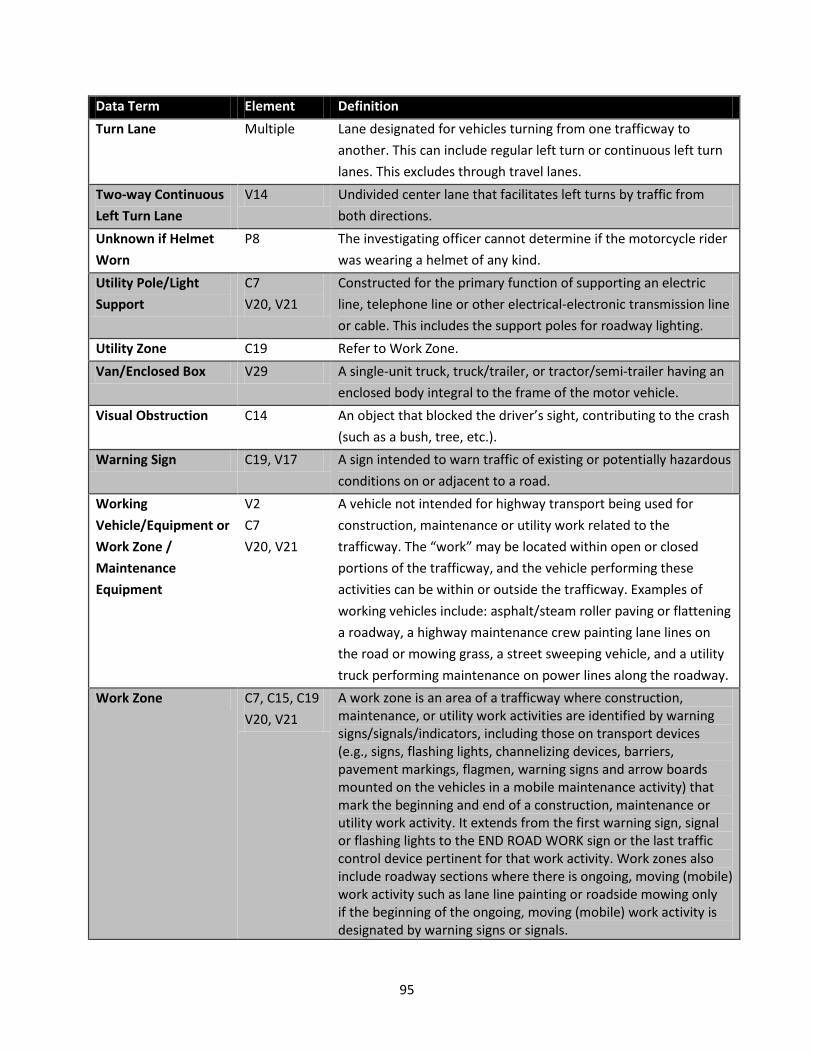
95
Data Term Element Definition Turn Lane Multiple Lane designated for vehicles turning from one trafficway to
another. This can include regular left turn or continuous left turn lanes. This excludes through travel lanes.
Two-way Continuous Left Turn Lane
V14 Undivided center lane that facilitates left turns by traffic from both directions.
Unknown if Helmet Worn
P8 The investigating officer cannot determine if the motorcycle rider was wearing a helmet of any kind.
Utility Pole/Light Support
C7 V20, V21
Constructed for the primary function of supporting an electric line, telephone line or other electrical-electronic transmission line or cable. This includes the support poles for roadway lighting.
Utility Zone C19 Refer to Work Zone. Van/Enclosed Box V29 A single-unit truck, truck/trailer, or tractor/semi-trailer having an
enclosed body integral to the frame of the motor vehicle. Visual Obstruction C14 An object that blocked the driver’s sight, contributing to the crash
(such as a bush, tree, etc.). Warning Sign C19, V17 A sign intended to warn traffic of existing or potentially hazardous
conditions on or adjacent to a road. Working Vehicle/Equipment or Work Zone / Maintenance Equipment
V2 C7 V20, V21
A vehicle not intended for highway transport being used for construction, maintenance or utility work related to the trafficway. The “work” may be located within open or closed portions of the trafficway, and the vehicle performing these activities can be within or outside the trafficway. Examples of working vehicles include: asphalt/steam roller paving or flattening a roadway, a highway maintenance crew painting lane lines on the road or mowing grass, a street sweeping vehicle, and a utility truck performing maintenance on power lines along the roadway.
Work Zone C7, C15, C19 V20, V21
A work zone is an area of a trafficway where construction, maintenance, or utility work activities are identified by warning signs/signals/indicators, including those on transport devices (e.g., signs, flashing lights, channelizing devices, barriers, pavement markings, flagmen, warning signs and arrow boards mounted on the vehicles in a mobile maintenance activity) that mark the beginning and end of a construction, maintenance or utility work activity. It extends from the first warning sign, signal or flashing lights to the END ROAD WORK sign or the last traffic control device pertinent for that work activity. Work zones also include roadway sections where there is ongoing, moving (mobile) work activity such as lane line painting or roadside mowing only if the beginning of the ongoing, moving (mobile) work activity is designated by warning signs or signals.

96
Data Term Element Definition Work Zone Crash C19 A work zone crash is a traffic crash in which the first harmful
event occurs within the boundaries of a work zone or on an approach to or exit from a work zone, resulting from an activity, behavior or control related to the movement of the traffic units through the work zone. Includes collision and non-collision crashes occurring within the signs or markings indicating a work zone or occurring on approach to, exiting from or adjacent to work zones that are related to the work zone. For example: 1) An automobile on the roadway loses control within a work zone due to a shift or reduction in the travel lanes and crashes into another vehicle in the work zone; 2) A van in an open travel lane strikes a highway worker in the work zone; 3) A highway construction vehicle working on the edge of the roadway is struck by a motor vehicle in transport in a construction zone; 4) a rear-end collision crash occurs before the signs or markings indicating a work zone due to vehicles slowing or stopped on the roadway because of the work zone activity; 5) A pickup in transport loses control in an open travel lane within a work zone due to a shift or reduction in the travel lanes and crashes into another vehicle which exited the work zone; 6) A tractor-trailer approaching an intersection where the other roadway has a work zone strikes a pedestrian outside the work zone because of lack of visibility caused by the work zone equipment. Excludes single-vehicle crashes involving working vehicles not located in trafficway. For example: 1) A highway maintenance truck strikes a highway worker inside the work site; 2) A utility worker repairing the electrical lines over the trafficway falls from the bucket of a cherry picker.
Work Zone/Maintenance Equipment
C7 V20, V21
A motor vehicle in the act of performing construction, maintenance, or utility work related to the trafficway. This “work” may be located within open or closed portions of the trafficway and motor vehicles performing these activities can be within or outside of the trafficway boundaries.
Worn, Travel-Polished Surface
C15 A road surface that is well used, often very smooth or shiny in appearance.
Wrong-Way Riding or Walking
P24 A non-motorist walking or riding in a direction other than required by statute.

97
Data Term Element Definition Y-Intersection C17 An intersection where three roadways connect and none of the
roadways continue across the other roadways. The roadways form a “Y.”
Yield Sign V17 Three-sided signs that require motor vehicles to give way to other vehicles.

98
Appendix A: MMUCC 2011-2012 Expert Panel Members Contact listAustin, Rory Special Assistant Office of Vehicle Safety USDOT/NHTSA 1200 New Jersey Avenue, SE Room: W55-320 Washington, DC 20590 Phone: 202-366-2719 E-mail: [email protected] Austin, Thomas Management Analyst Florida Dept. of Highway Safety & Motor Vehicles 2900 Apalachee Parkway Tallahassee, FL 32399 Phone: 850-617-3275 E-mail: [email protected] Baker, Dave Business Process Analyst Ohio State Highway Patrol 1970 West Broad St. Columbus, OH 43223 Phone: 614-752-0244 E-mail: [email protected] Bean, James Crash Investigation Specialist USDOT/NHTSA 1200 New Jersey Ave., SE Room W53-489 Washington, DC 20590 Phone: 202-366-2837 E-mail: [email protected] Bragan, Tom Program Analyst USDOT/NHTSA 1200 New Jersey Ave., SE Room W53-456 Washington, DC 20590 Phone: 202-366-6978 E-mail: [email protected]
Bratt, Barry Major Colorado State Patrol 554 Jurassic Court District Four - CSP Fruita, CO 81521 Phone: 970-858-2250 E-mail: [email protected] Carrico, John Captain Kentucky State Police 1266 Louisville Road, Bldg. B Frankfort, KY 40601 Phone: 502-227-8700 E-mail: [email protected] Chappelle, Reginald Chief California Highway Patrol 4115 Broad Street, Suite B-10 San Luis Obispo, CA 93401 Phone: 805-549-3261 E-mail: [email protected] Craft, Ralph Crash Data Analyst USDOT/FMCSA 10617 John Ayres Drive Fairfax, VA 22023 Phone: 202-366-0324 E-mail: [email protected] Dellinger, Ann Epidemiologist & Team Leader Centers for Disease Control & Prevention 4770 Buford Highway NE Atlanta, GA 30341 Phone: 770-488-4811 E-mail: [email protected]

99
Edgell, Keith Captain - District Commander Montana Highway Patrol 615A S. 27th Street Billings, MT 59101 Phone: 406-896-4356 E-mail: [email protected] Flemons, Dennis Program Analyst - FARS USDOT/NHTSA 1200 New Jersey Ave., SE Room W53-448 Washington, DC 20590 Phone: 202-366-5389 E-mail: [email protected] Gainor, Dia Executive Director National Association of State EMS Officials 201 Park Washington Court Falls Church, VA 22046 Phone: 703-538-1799 x1702 E-mail: [email protected] Gayer, John Henderson Police Department 223 Lead St. Henderson, NV 89015 Phone: 702-267-4547 E-mail: [email protected] Hackman, Kenneth CEO, ANSI D16 Chairman National Institute for Safety Research, Inc. 326 Hill Top Road Oakland, MD 21550 Phone: 301-533-0750 E-mail: [email protected] Hage, James Operations/Management Consultant Florida Dept. of Highway Safety & Motor Vehicles 2900 Apalachee Parkway Tallahassee, FL 32399 Phone: 850-617-3202 E-mail: [email protected]
Haney, Kathleen Traffic Records Coordinator State of Minnesota 444 Cedar Street - Suite 150 St. Paul, MN 55101 Phone: 651-201-7064 E-mail: [email protected] Harkey, David Director UNC Highway Safety Research Center 730 ML King Jr Blvd. - CB# 3430 Chapel Hill, NC 27599 Phone: 919-962-8705 E-mail: [email protected] Harsha, Barbara Executive Director Governors Highway Safety Association 444 N. Capitol St., NW - Suite 722 Washington, DC 20001 Phone: 202-789-0942 E-mail: [email protected] Hedegaard, Holly EMS and Trauma Data Program Manager Colorado Dept. of Public Health & Environment 4300 Cherry Creek Drive South Denver, CO 80246 Phone: 303-898-6752 E-mail: [email protected] Hedlund, Jim Principal Highway Safety North 110 Homestead Road Ithaca, NY 14850-6216 Phone: 607-273-5645 E-mail: [email protected] Hill, Loren Consultant & Traffic Safety Engineer 1721 Cloud Dr. Blaine, MN 55449 Phone: 651-485-9772 E-mail: [email protected]

100
Jennings, Angelisa Deputy Director Virginia Highway Safety Office 2300 West Broad Street - Room 405 Richmond, VA 23220 Phone: 804-367-2026 E-mail: [email protected] King, Nils Traffic Records Coodinator Indiana Criminal Justice Institute 101 W. Washington St.- Suite 1170 East Indianapolis, IN 46204 Phone: 317-234-4318 E-mail: [email protected] Lindsey, Tonja Program Analyst USDOT/NHTSA 1200 New Jersey Ave., SE Room W55-326 Washington, DC 20590 Phone: 202-366-0854 E-mail: [email protected] Madill, Christopher Traffic Records Program Manager Washington Traffic Safety Commission 621 8th Avenue SE Olympia, WA 98504-0944 Phone: 360-725-9884 E-mail: [email protected] Martin, Robert Sergeant New Britain Police Department 125 Columbus Boulevard New Britain, CT 06051 Phone: 860-826-3013 E-mail: [email protected] McDonough, John President National Institute for Safety Research, Inc. 788 Connolly Drive Red Lion, PA 17356 Phone: 410-330-8052 E-mail: [email protected]
McHenry, Susan EMS Specialist USDOT/NHTSA 1200 New Jersey Ave., SE Washington, DC 20590 Phone: 202-366-6540 E-mail: [email protected] Meaney, Robert Chief of Police Medfield Police Department 110 North Street Medfield, MA 02052 Phone: 508-889-4988 E-mail: [email protected] Miller, John Traffic Safety Engineer Missouri DOT 1320 Creek Trail Drive Jefferson City, MO 65109 Phone: 573-526-1759 E-mail: [email protected] Pollack, Robert Safety Data Manager USDOT/FHWA 1200 New Jersey Ave., SE Washington, DC 20590 Phone: 202-366-5019 E-mail: [email protected] Pollock, Marty Sergeant Tennessee Department of Safety Research Planning & Development 1150 Foster Avenue Nashville, TN 37243 Phone: 615-743-3903 E-mail: [email protected] Price, Jana Investigator, Office of Highway Safety National Transportation Safety Board 490 L'Enfant Plaza, SW Washington, DC 20594 Phone: 202-314-6512 E-mail: [email protected]

101
Reed, Joanna Traffic Records Research & Alaska FARS Analyst Alaska Highway Safety Office Alaska DOT & Public Facilities 3132 Channel Dr. P.O. Box 112500 Juneau, AK 99811-2500 Phone: 907-465-8532 E-mail: [email protected] Rhea, Barbara Chief, State Data Reporting Systems Division USDOT/NHTSA 1200 New Jersey Ave., SE Washington, DC 20590 Phone: 202-366-2714 E-mail: [email protected] Scott-Walls, Bonnie Program Manager Florida Dept. of Highway Safety & Motor Vehicles 2900 Apalachee Parkway - MS 89 Tallahassee, FL 32399 Phone: 850-617-2589 E-mail: [email protected] Sullivan, Kaye Manager, Safety Data Analysis Ford Motor Company Fairlane Plaza South - Suite 500 330 Town Center Drive Dearborn, MI 48134 Phone: 313-594-9673 E-mail: [email protected] Tan, Carol Team Leader, Safety Management Federal Highway Administration Turner-Fairbank Highway Research Center 6300 Georgetown Pike, HRDS-20 McLean, VA 22101 Phone: 202-493-3315 E-mail: [email protected]
Wells, JoAnn Senior Research Scientist Insurance Institute for Highway Safety 1005 N.Glebe Road - Suite 800 Arlington, VA 22201 Phone: 703 -247-1573 E-mail: [email protected]

102
Appendix B: Summary of Changes to the MMUCC Guideline, 3rd Edition (2008) Crash Data Elements Collected at Scene Element 2008 Element 2012 Element Name New definition New attribute(s) Comments
C1 C1 Case Identifier C2 Crash
Classification X X New data element with
two subfields: Subfield 1 • Public Property • Private Property Subfield 2 • Trafficway, On Road • Trafficway, Not On
Road • Non-Trafficway
C2 C3 Crash Date and Time
C3 C4 Crash County X Inserted “physically” before “occurred” in definition.
C4 C5 Crash City/Place
C5 C6 Crash Location C6 C7 First Harmful
Event X Changed attributes
“Immersion” to “Immersion, Full or Partial” and “Animal” to “Animal (live)” Added attribute “Other Non-Motorist”
C7 C8 Location of First Harmful
Event Relative to the
Trafficway
C8 C9 Manner of Crash/Collision
Impact
C9 C10 Source of Information
C10 C11 Weather Conditions
X Deleted attribute “Sleet, Hail (freezing rain or drizzle” and added attributes “Sleet or Hail” and “Freezing Rain or Freezing Drizzle”
C11 C12 Light Condition

103
Element 2008 Element 2012 Element Name New definition New attribute(s) Comments C12 C13 Roadway
Surface Condition
C13 C14 Contributing Circumstances,
Environment
X Changed attribute “Physical Obstruction(s)” to “Visual Obstruction(s)”
C14 C15 Contributing Circumstances,
Road
X Added attributes: • Backup Due to Prior
Crash • Backup Due to Prior
Non-Recurring Inci-dent
• Backup due to Reg-ular Congestion
• Toll Booth/Plaza Re-lated
C15 C16 Relation to Junction
X X Subfield 1 now “Within Interchange Area” • No • Yes • Unknown Subfield 2 now “Specific Location” Same as old Subfield 1 “Junction” with attribute “Driveway/Alley Access Related” deleted and the following attributes added: • Entrance/Exit Ramp
Related • Driveway Access • Driveway Ac-
cess-Related C16 C17 Type of
Intersection X Added attribute “L
Intersection” C17 C18 School Bus
Related
C18 C19 Work Zone-Related (Construction / Maintenance /
Utility)

104
Vehicle Data Elements Collected at Scene Element 2008 Element 2012 Element Name New definition New attribute(s) Comments
V1 V1 Motor Vehicle Identification
Number (VIN)
V2 V2 Motor Vehicle Unit Type and Number
V3 V3 Motor Vehicle Registration State
and Year
X Added reference to Appendix D State and Province Codes
V4 V4 Motor Vehicle License Plate
Number
V5 V5 Motor Vehicle Make
V6 V6 Motor Vehicle Model Year
V7 V7 Motor Vehicle Model
V8 V8 Motor Vehicle Body Type Category
X Added attribute “Golf Cart” and added “GVWR” to attributes which included reference to weight. Deleted “(e.g., farm equipment, heavy machinery)” from attribute “Other”
V9 V9 Total Occupants in Motor Vehicle
V10 V10 Special Function of Motor Vehicle in
Transport
X Added attributes: • Non-Transport
Emergency Services Vehicle
• Incident Response V11 V11 Emergency Motor
Vehicle Use X Attributes now:
• Not applicable • Non-emergency,
non-transport • Non-emergency
transport • Emergency opera-
tion, emergency warning equipment not in use
• Emergency opera-tion, emergency warning equipment In use
• Unknown V12 V12 Motor Vehicle
Posted/Statutory Speed Limit
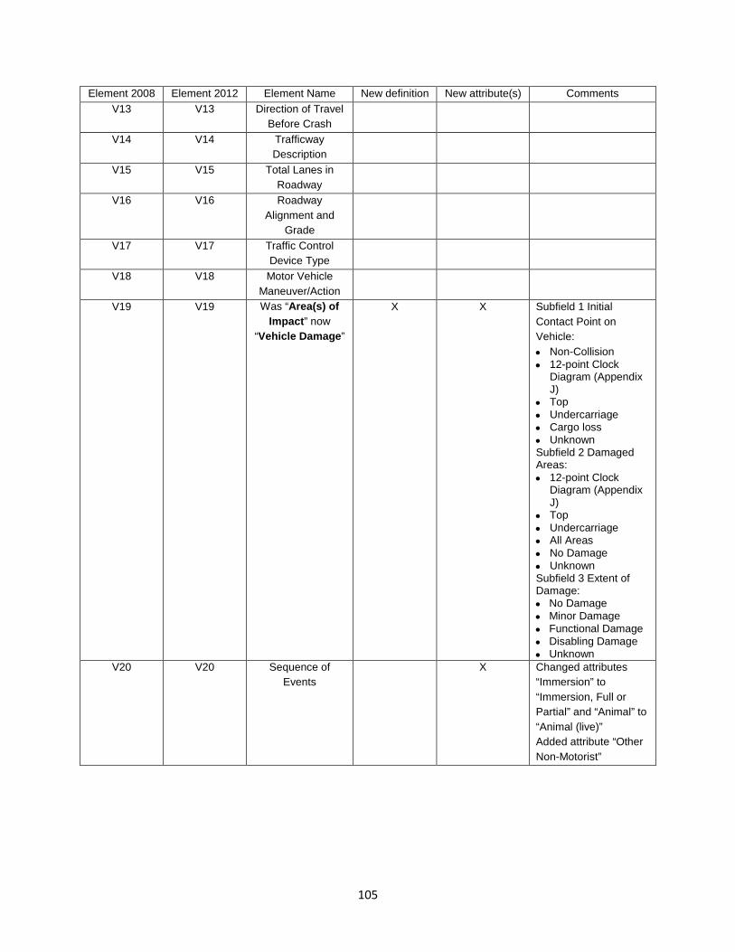
105
Element 2008 Element 2012 Element Name New definition New attribute(s) Comments V13 V13 Direction of Travel
Before Crash
V14 V14 Trafficway Description
V15 V15 Total Lanes in Roadway
V16 V16 Roadway Alignment and
Grade
V17 V17 Traffic Control Device Type
V18 V18 Motor Vehicle Maneuver/Action
V19 V19 Was “Area(s) of Impact” now
“Vehicle Damage”
X X Subfield 1 Initial Contact Point on Vehicle: • Non-Collision • 12-point Clock
Diagram (Appendix J)
• Top • Undercarriage • Cargo loss • Unknown Subfield 2 Damaged Areas: • 12-point Clock
Diagram (Appendix J)
• Top • Undercarriage • All Areas • No Damage • Unknown Subfield 3 Extent of Damage: • No Damage • Minor Damage • Functional Damage • Disabling Damage • Unknown
V20 V20 Sequence of Events
X Changed attributes “Immersion” to “Immersion, Full or Partial” and “Animal” to “Animal (live)” Added attribute “Other Non-Motorist”

106
Element 2008 Element 2012 Element Name New definition New attribute(s) Comments V21 V21 Most Harmful Event X Changed attributes
“Immersion” to “Immersion, Full or Partial” and “Animal” to “Animal (live)” Added attribute “Other Non-Motorist”
V22 V22 Bus Use V23 V23 Hit and Run V24 V24 Was “Extent of
Damage/Removal” now “Towed Due
to Disabling Damage”
X X New attributes: • Towed Due to Dis-
abling Damage • Towed, But Not Due
to Disabling Dam-age
• Not Towed V25 V25 Contributing
Circumstances, Motor Vehicle
V26 V26 Motor Vehicle Identification
V27 V27 Gross Vehicle Weight Rating /
Gross Combination Weight Rating
V28 V28 Vehicle Configuration
V29 V29 Cargo Body Type X Added reference to Appendix K Definitions for Truck Configurations and Placards
V30 V30 Hazardous Materials (Cargo
Only)
X Added reference to Appendix K Definitions for Truck Configurations and Placards
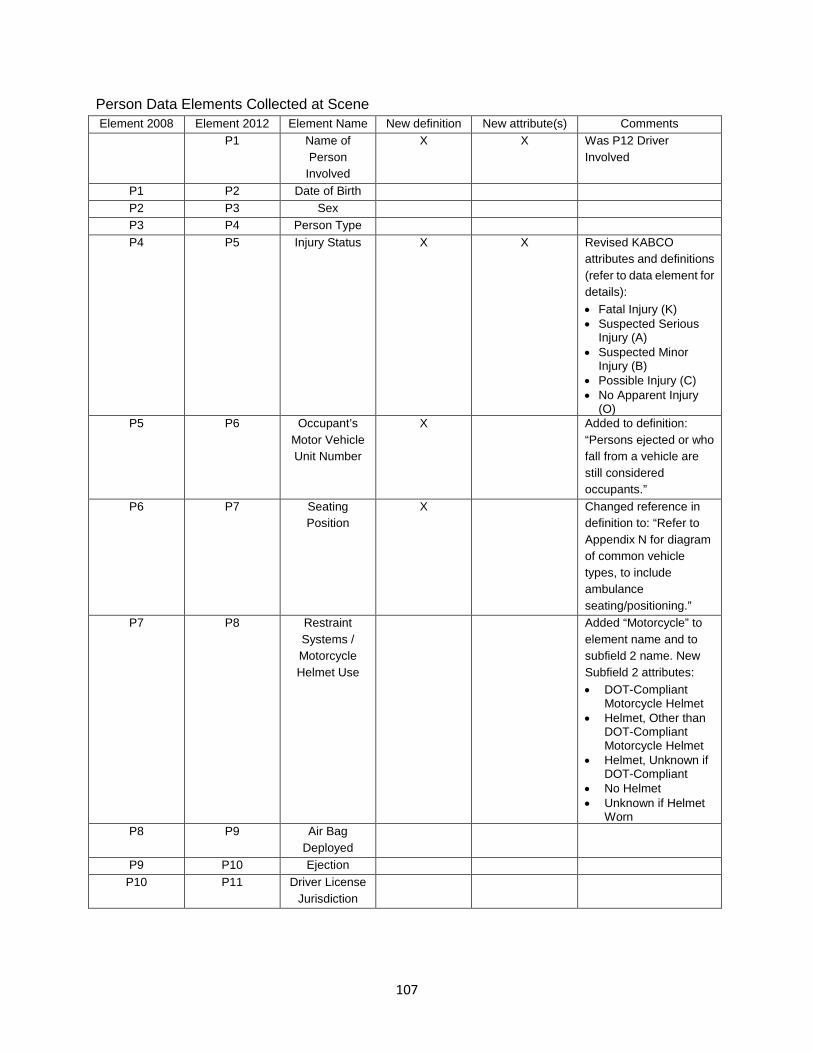
107
Person Data Elements Collected at Scene Element 2008 Element 2012 Element Name New definition New attribute(s) Comments
P1 Name of Person
Involved
X X Was P12 Driver Involved
P1 P2 Date of Birth P2 P3 Sex P3 P4 Person Type P4 P5 Injury Status X X Revised KABCO
attributes and definitions (refer to data element for details): • Fatal Injury (K) • Suspected Serious
Injury (A) • Suspected Minor
Injury (B) • Possible Injury (C) • No Apparent Injury
(O) P5 P6 Occupant’s
Motor Vehicle Unit Number
X Added to definition: “Persons ejected or who fall from a vehicle are still considered occupants.”
P6 P7 Seating Position
X Changed reference in definition to: “Refer to Appendix N for diagram of common vehicle types, to include ambulance seating/positioning.”
P7 P8 Restraint Systems / Motorcycle Helmet Use
Added “Motorcycle” to element name and to subfield 2 name. New Subfield 2 attributes: • DOT-Compliant
Motorcycle Helmet • Helmet, Other than
DOT-Compliant Motorcycle Helmet
• Helmet, Unknown if DOT-Compliant
• No Helmet • Unknown if Helmet
Worn P8 P9 Air Bag
Deployed
P9 P10 Ejection P10 P11 Driver License
Jurisdiction

108
Element 2008 Element 2012 Element Name New definition New attribute(s) Comments P11 P12 Driver License
Number, Class, CDL,
and Endorsements
P12 Driver Name Deleted (Replaced by P1 Name of Person Involved)
P13 Speed Related X X New data element: • Racing • Exceeded Speed
Limit • Too Fast for Condi-
tions • No • Unknown
P13 P14 Driver Actions at Time of
Crash
Deleted attributes: • Exceeded Posted
Speed Limit • Drove Too Fast for
Conditions (Refer to new element Speed Related) Replaced attribute: “Operated Motor Vehicle in Erratic, Reckless, Careless, Negligent or Aggressive Manner” with attributes “Operated Motor Vehicle in Reckless or Aggressive Manner” and Operated Motor Vehicle in Inattentive, Careless, Negligent, or Erratic Manner”
P14 P15 Violation Codes

109
Element 2008 Element 2012 Element Name New definition New attribute(s) Comments P15 P16 Driver
Distracted By X X Attributes:
• Not Distracted • Manually operating
an electronic communication de-vice (texting, typ-ing, dialing)
• Talking on hands-free elec-tronic device
• Talking on hand-held elec-tronic device
• Other activity, electronic device
• Passenger • Other Inside the
Vehicle (eating, personal hygiene, etc.)
• Outside the vehicle (includes unspeci-fied external dis-tractions)
• Unknown if Dis-tracted
P16 P17 Condition at Time of Crash
Added subfield 2 (for reporting second condition)
P17 P18 Law Enforcement
Suspects Alcohol Use
P18 P19 Alcohol Test P19 P20 Law
Enforcement Suspects Drug
Use
P20 P21 Drug Test P21 P22 Non-Motorist
Number

110
Element 2008 Element 2012 Element Name New definition New attribute(s) Comments P22 P23 Non-Motorist
Action / Circumstance Prior to Crash
X Added 2nd Subfield Going To or From School (K-12): No Yes Unknown 1st Subfield Action Circumstances Deleted attribute “Going to or from school (K-12) and deleted parenthetical that followed attribute “In Roadway – Other”
P23 P24 Non-Motorist Actions /
Circumstances at Time of
Crash
P24 P25 Non-Motorist Location at
Time of Crash
P25 P26 Non-Motorist Safety
Equipment
P26 P27 Unit Number of Motor Vehicle
Striking Non-Motorist
P27 P28 Transported to First Medical
Facility By
X Added “First” to data element name and to definition and to subfield one name
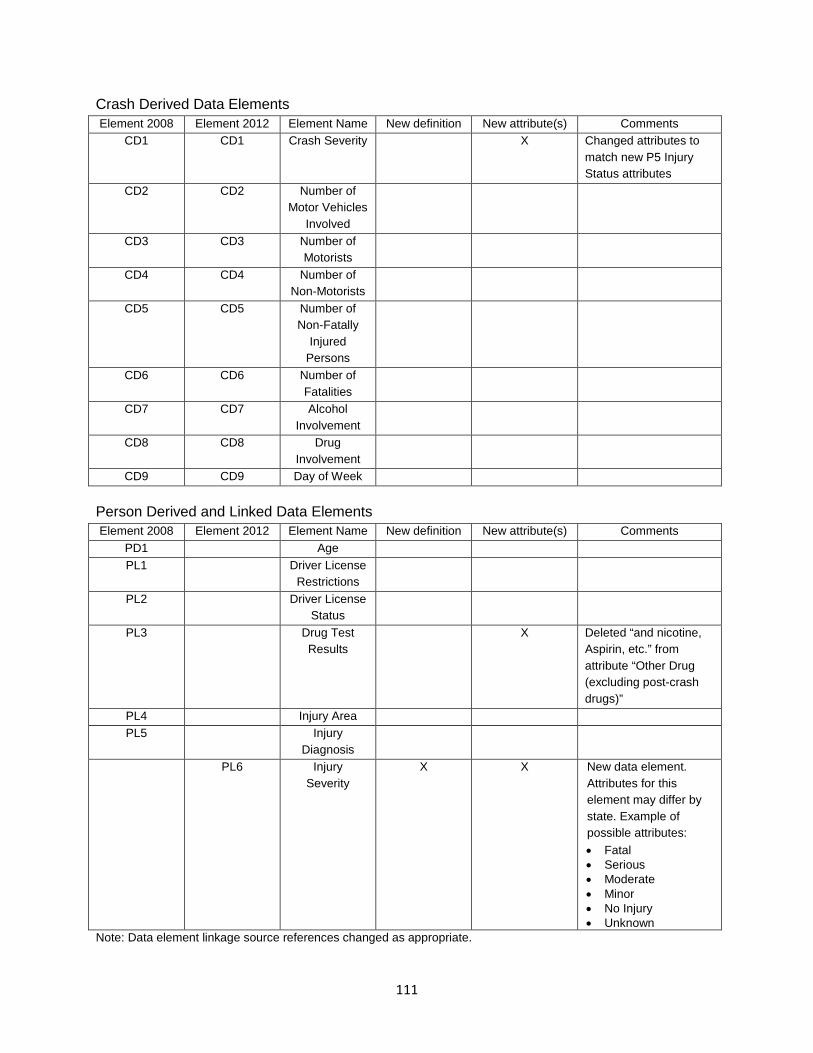
111
Crash Derived Data Elements Element 2008 Element 2012 Element Name New definition New attribute(s) Comments
CD1 CD1 Crash Severity X Changed attributes to match new P5 Injury Status attributes
CD2 CD2 Number of Motor Vehicles
Involved
CD3 CD3 Number of Motorists
CD4 CD4 Number of Non-Motorists
CD5 CD5 Number of Non-Fatally
Injured Persons
CD6 CD6 Number of Fatalities
CD7 CD7 Alcohol Involvement
CD8 CD8 Drug Involvement
CD9 CD9 Day of Week Person Derived and Linked Data Elements Element 2008 Element 2012 Element Name New definition New attribute(s) Comments
PD1 Age PL1 Driver License
Restrictions
PL2 Driver License Status
PL3 Drug Test Results
X Deleted “and nicotine, Aspirin, etc.” from attribute “Other Drug (excluding post-crash drugs)”
PL4 Injury Area PL5 Injury
Diagnosis
PL6 Injury Severity
X X New data element. Attributes for this element may differ by state. Example of possible attributes: • Fatal • Serious • Moderate • Minor • No Injury • Unknown
Note: Data element linkage source references changed as appropriate.

112
Appendix C: Date and Time Formats DATE Numbers are always right justified. Use leading zeroes when necessary. Subfield 1: Year nnnn Year 7777 Permanent 8888 Indefinite 9999 Unknown Subfield 2: Month 01 January 02 February 03 March 04 April 05 May 06 June 07 July 08 August 09 September 10 October 11 November 12 December 77 Permanent 88 Indefinite 99 Unknown Subfield 3: Day nn Day of Month 77 Permanent 88 Indefinite 99 Unknown EXAMPLES: The fifth of March, nineteen ninety-two is coded 19920305 TIME Subfield 1: Hour nn 0-23, representing the time on a 24-hour clock 99 Unknown Subfield 2: Minute nn Minute 99 Unknown EXAMPLES: 11:55 p.m. would be coded 2355, Midnight is coded 0000 and is the beginning of a new day, not the end of the preceding day. Source: ANSI D20.1 Data Element dictionary for Traffic Records Systems
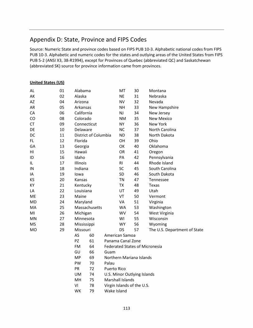
113
Appendix D: State, Province and FIPS Codes Source: Numeric State and province codes based on FIPS PUB 10-3. Alphabetic national codes from FIPS PUB 10-3. Alphabetic and numeric codes for the states and outlying areas of the United States from FIPS PUB 5-2 (ANSI X3, 38-R1994), except for Provinces of Quebec (abbreviated QC) and Saskatchewan (abbreviated SK) source for province information came from provinces.
United States (US)
AL 01 Alabama MT 30 Montana AK 02 Alaska NE 31 Nebraska AZ 04 Arizona NV 32 Nevada AR 05 Arkansas NH 33 New Hampshire CA 06 California NJ 34 New Jersey CO 08 Colorado NM 35 New Mexico CT 09 Connecticut NY 36 New York DE 10 Delaware NC 37 North Carolina DC 11 District of Columbia ND 38 North Dakota FL 12 Florida OH 39 Ohio GA 13 Georgia OK 40 Oklahoma HI 15 Hawaii OR 41 Oregon ID 16 Idaho PA 42 Pennsylvania IL 17 Illinois RI 44 Rhode Island IN 18 Indiana SC 45 South Carolina IA 19 Iowa SD 46 South Dakota KS 20 Kansas TN 47 Tennessee KY 21 Kentucky TX 48 Texas LA 22 Louisiana UT 49 Utah ME 23 Maine VT 50 Vermont MD 24 Maryland VA 51 Virginia MA 25 Massachusetts WA 53 Washington MI 26 Michigan WV 54 West Virginia MN 27 Minnesota WI 55 Wisconsin MS 28 Mississippi WY 56 Wyoming MO 29 Missouri DS 57 The U.S. Department of State AS 60 American Samoa PZ 61 Panama Canal Zone FM 64 Federated States of Micronesia GU 66 Guam MP 69 Northern Mariana Islands PW 70 Palau PR 72 Puerto Rico UM 74 U.S. Minor Outlying Islands MH 75 Marshall Islands VI 78 Virgin Islands of the U.S. WK 79 Wake Island

114
Canada (CN) AB 01 Alberta ON 08 Ontario BC 02 British Columbia PE 09 Prince Edward Island MB 03 Manitoba QC 10 Quebec NB 04 New Brunswick SK 11 Saskatchewan NF 05 Newfoundland YT 12 Yukon Territory NT 06 Northwest Territory NU 13 Nunavut NS 07 Nova Scotia Mexico (MX) AG 01 Aguascalientes MR 17 Moreios BA 02 Baja California Norte NA 18 Nayarit BJ 03 Baja California Sur NL 19 Nuevo Leon CM 04 Campeche OA 20 Oaxaca CI 05 Chiapas PB 21 Puebla CH 06 Chihuahua QU 22 Queretero de Arteaga CU 07 Coahuila de Zaragoza QR 23 Quintana Roo CL 08 Colima SL 24 San Luis Potosi DF 09 Distrito Federal SI 25 Sinaloa DO 10 Durango SO 26 Sonora GT 11 Guanajuato TB 27 Tabasco GR 12 Guerrero TA 28 Tamaulipas HL 13 Hidalgo TL 29 Tlaxcala JL 14 Jalisco VC 30 Veracruz-Llava MX 15 Mexico YU 31 Yucatan MC 16 Michoacan de Ocampo ZA 32 Zacatecas Other Jurisdictions (OT) OT 99 Jurisdictions other than States or provinces of the United States, Canada, and Mexico (includes Indian Reservations) Note: Code with country and State or province. Where there is no chance of ambiguity, State or province codes may be used without the country code. (Note that State and province codes are unique within each country but may be duplicated in other countries.) EXAMPLE: Alabama may be coded as USAL or US01. Chihuahua may be coded as MSCH or MX06. Federal Information Processing Standards (FIPS) Codes for Locations Standardized codes for States, counties, cities/towns are published by the National Bureau of Standards in the Federal Information Processing Standards (FIPS) Register.
FIPS Publication 5-2 (May 1987): Codes for States, District of Columbia, and outlying areas
FIPS Publication 6-4 (August 31, 1990): Codes for Counties, County Equivalents of the States of United States, District of Columbia
FIPS Publication 8-6 (March 1995) Codes for: Metropolitan Statistical Areas (MSAs), Consolidated Metropolitan Statistical Areas (CMSAs), Primary Metropolitan Statistical Areas (PMASs), New England County Metropolitan Areas (NeCMAs)
FIPS Publication 10-4 (April 1995): Codes for Countries, Dependencies, Areas of Special Sovereignty, and Their Principal Administrative Divisions

115
Appendix E: Diagram of the Trafficway
Source: ANSI D16.2-2007 Manual on Classification of Motor Vehicle Traffic Accidents, Seventh Edition
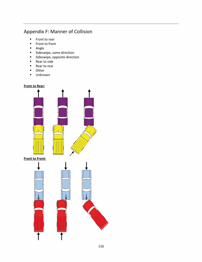
116
Appendix F: Manner of Collision Front to rear Front to front Angle Sideswipe, same direction Sideswipe, opposite direction Rear to side Rear to rear Other Unknown
Front to Rear:
Front to Front:

117
Angle:
Sideswipe, Same Direction:
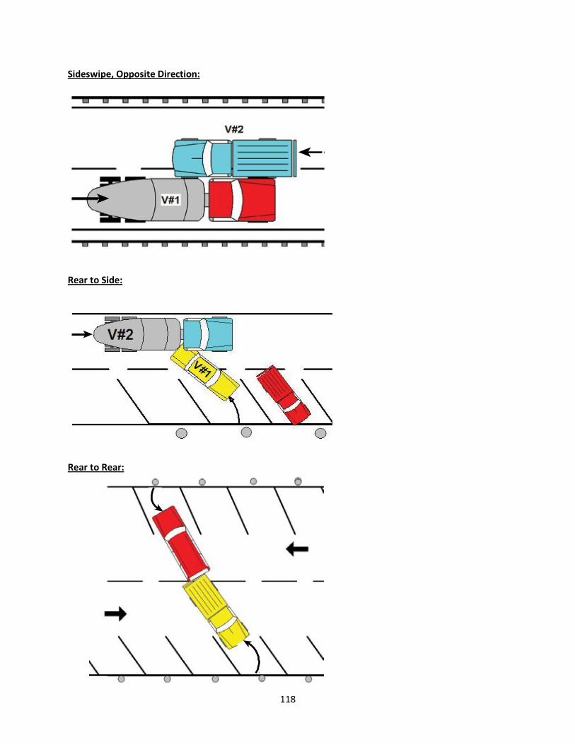
118
Sideswipe, Opposite Direction:
Rear to Side:
Rear to Rear:

119
Appendix G: Diagram of an Interchange
Source: ANSI D16.2-2007 Manual on Classification of Motor Vehicle Traffic Accidents, Seventh Edition

120
Appendix H: Diagram of an Intersection
Source: ANSI D16.2-2007 Manual on Classification of Motor Vehicle Traffic Accidents, Seventh Edition
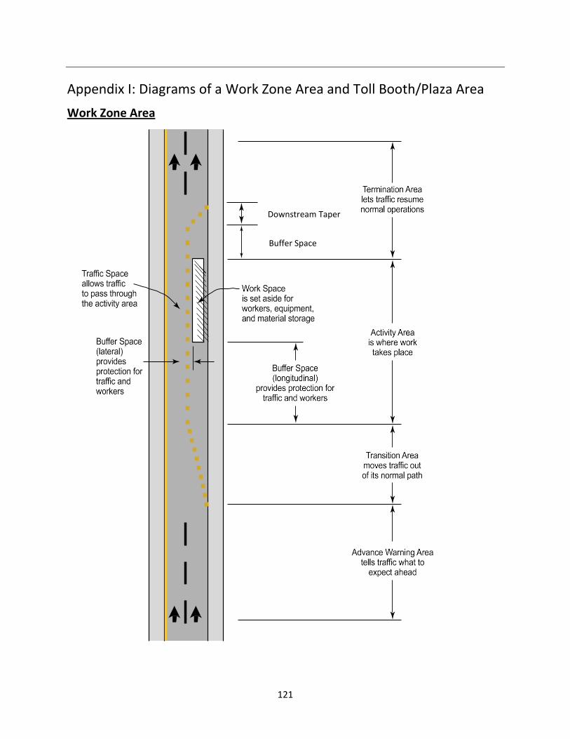
121
Appendix I: Diagrams of a Work Zone Area and Toll Booth/Plaza Area Work Zone Area
Downstream Taper
Buffer Space

122
Toll Booth/Plaza Area
TOLL BOOTH
Source: FHWA

123
Appendix J: Clockpoint Diagrams for Different Types of Motor Vehicles
Source: FARS Coding Manual

124
Appendix K: Definitions for Truck Configurations and Placards
Source: FMCSA

125

126

127
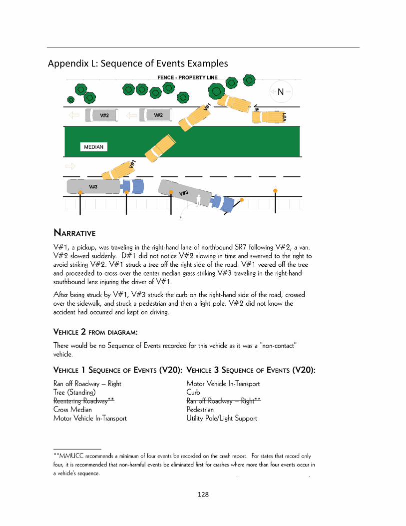
128
Appendix L: Sequence of Events Examples
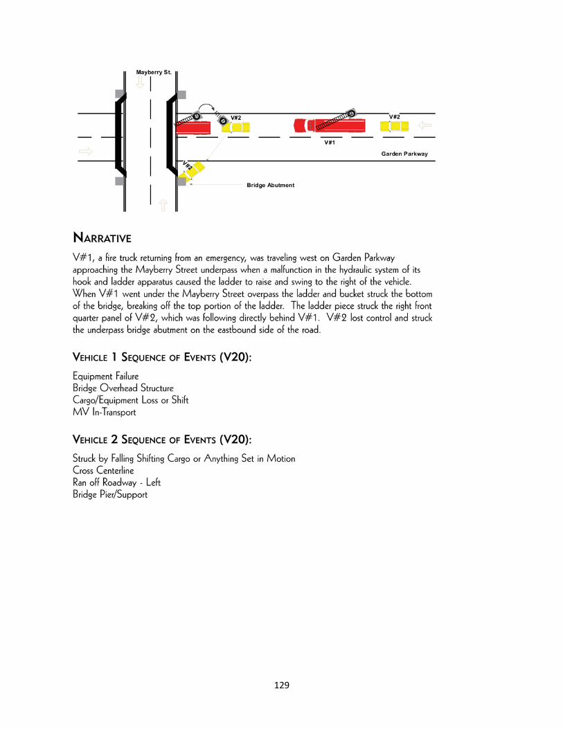
129

130

131
Side
Other
Side
Front
Front Curtain
Appendix M: Air Bags Diagram
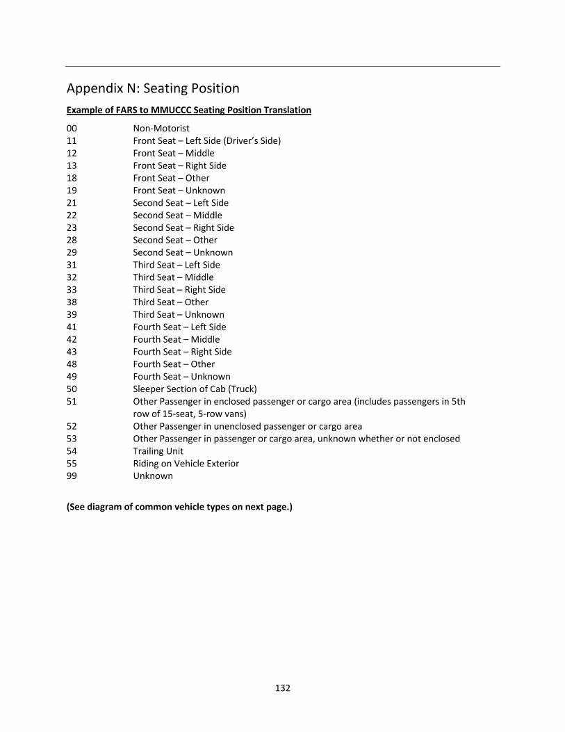
132
Appendix N: Seating Position Example of FARS to MMUCCC Seating Position Translation
00 Non-Motorist 11 Front Seat – Left Side (Driver’s Side) 12 Front Seat – Middle 13 Front Seat – Right Side 18 Front Seat – Other 19 Front Seat – Unknown 21 Second Seat – Left Side 22 Second Seat – Middle 23 Second Seat – Right Side 28 Second Seat – Other 29 Second Seat – Unknown 31 Third Seat – Left Side 32 Third Seat – Middle 33 Third Seat – Right Side 38 Third Seat – Other 39 Third Seat – Unknown 41 Fourth Seat – Left Side 42 Fourth Seat – Middle 43 Fourth Seat – Right Side 48 Fourth Seat – Other 49 Fourth Seat – Unknown 50 Sleeper Section of Cab (Truck) 51 Other Passenger in enclosed passenger or cargo area (includes passengers in 5th row of 15-seat, 5-row vans) 52 Other Passenger in unenclosed passenger or cargo area 53 Other Passenger in passenger or cargo area, unknown whether or not enclosed 54 Trailing Unit 55 Riding on Vehicle Exterior 99 Unknown
(See diagram of common vehicle types on next page.)
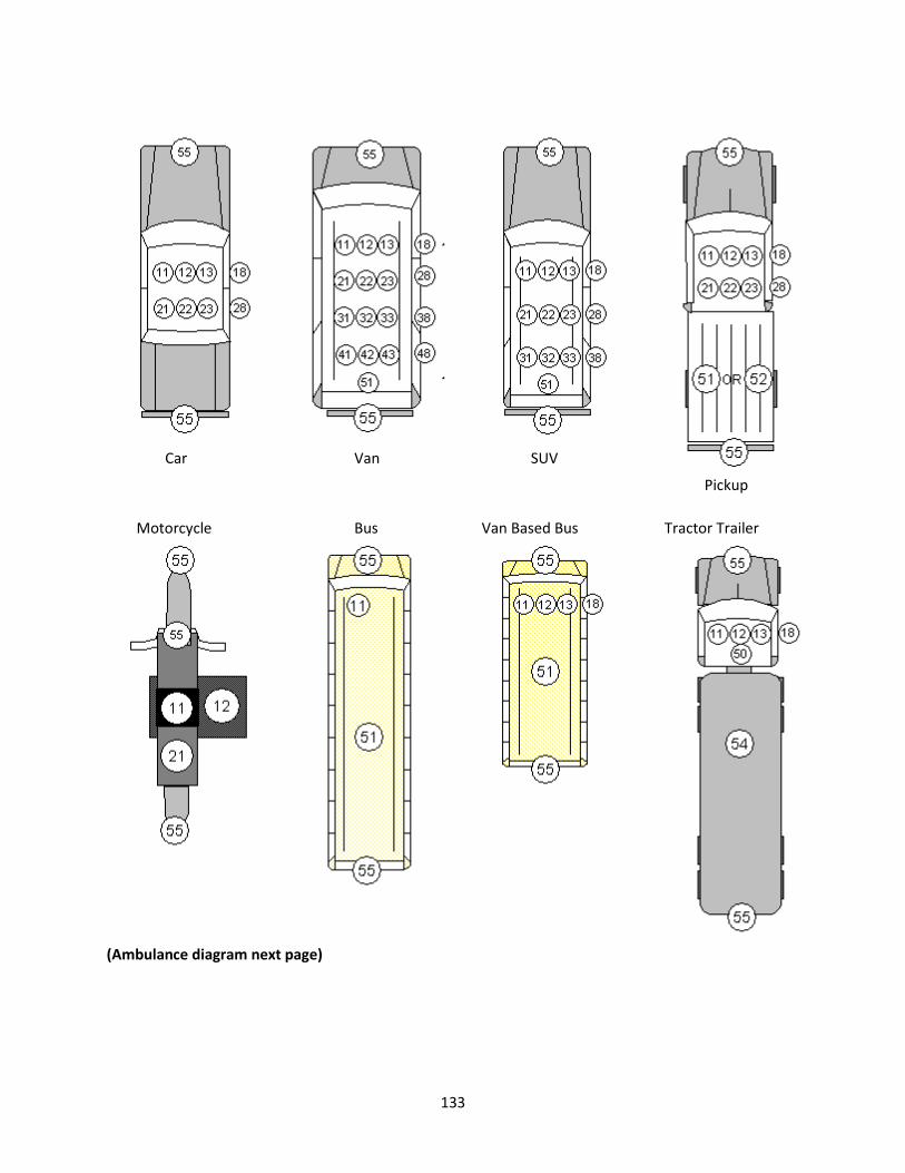
133
Car Van SUV
Pickup
Tractor Trailer Van Based Bus Bus Motorcycle
(Ambulance diagram next page)

134
Example of Conventional Ambulance, MMUCC Seating Position Translation
1 Front seat row, left (driver) 2 Front, right (passenger) 3 Second, middle (EMT seat at head of patient) 4 Second, right (patient reclining on bench seat) 5 Third, middle (Standing, unseated) 6 Third, right (Seated in forward most position on bench
seat) 7 Fourth, left (EMT seat at side of patient) 8 Fourth, middle (Patient on stretcher/cot) 9 Fourth, right (Seated in center position on bench seat) 10 Other, right (Seated in rear most position on bench
seat)


MMUCC GuidelineModel Minimum Uniform Crash Criteria
Fourth Edition (2012)
DOT HS 811 631July 2012
8718-070212-v4a