does history matter? development differences in poland
TRANSCRIPT
1
DOES HISTORY MATTER? DEVELOPMENT DIFFERENCES IN POLAND
P.CHURSKI , B.KONECKA-SZYDŁOWSKA, T.HERODOWICZ, R.PERDAŁ
Faculty of Socio-Economic Geography and Spatial Management
Adam Mickiewicz University
Bogumiła Krygowskiego street 10, Collegium Geographicum
61-680 POZNAŃ, Poland
The analysis aims to present and assess the impact of historical factors on the differences in
socio-economic development of Poland at the local level and to compare them to the results of
other research that show the effects of similar analyses carried out for the countries of Central
and Eastern Europe. The study is based on the analysis of spatial diversification of the socio-
economic development level classes and indicators of the electoral support structure of residents
by means of spatial regression methods. The spatial scope of the work includes the local, or the
commune level (LAU2) and furthermore takes into account the division of the present-day
territory of Poland by the relict borders of partitions (1772, 1793, 1795), established at the
Congress of Vienna (1815) and the course of Poland's borders between the world wars (1918-
1939), conclusively determined in 1922. The main timeline of the study is the years 2004-2016
and, retrospectively, the 1815-1939 period.
2
Introduction
Europe's socio-economic space is one of the most experienced in terms of the impact of
historical events of breakthrough development shocks, which affect its diversity. Central and
Eastern Europe is unique in this respect. The number and scale of war conflicts and their
consequences in the form of changes in the political borders of individual countries and regions
have taken root in this space, becoming an important determinant differentiating development
opportunities (Huntington, 1998; Prescott and Triggs, 2008). Their importance is currently
increasing in the absence of satisfactory effects of cohesion policy interventions, both at the EU
level and within individual Member States (Fratesi and Rodríguez-Pose, 2016).
This analysis aims to present and assess the impact of historical factors on the
differences in socio-economic development of Poland at the local level and to compare them to
the results of other studies that show the effects of similar analyses carried out for the countries
of Central and Eastern Europe. The study is based on the analysis of spatial diversification of
the socio-economic development level classes and indicators of the electoral support structure
of residents by means of spatial regression methods. The spatial scope of the work includes the
local, or the commune level (LAU2) and furthermore takes into account the division of the
present-day territory of Poland by the relict borders of partitions (1772, 1793, 1795), established
at the Congress of Vienna (1815) and the course of Poland's borders between the world wars
(1918-1939), conclusively determined in 1922. The main timeline of the study is the years
2004-2016 and, retrospectively, the 1815-1939 period.
The investigation algorithm consists of five stages. In the first stage, a review of the
research on the relict boundaries and their importance in the spatial differentiation of socio-
economic developments in Central and Eastern Europe was carried out. In the second stage, the
division of Poland's today's territory by the relict borders was discussed. In the next, third stage
the results of the analysis of differentiation of the level of social and economic development of
local units, taking into account the map of relict borders, were presented. Stage four was
devoted to the description of the spatial distribution of political preferences in the system of
local units in the context of historical conditions. In the final, fifth stage, the regularities and
relationships between the relict borders and the spatial distribution of the socio-economic
development level and political preferences at the local level were discussed.
The model approach applied in this study corresponds to the developmental differences
highlighted in the latest results of spatial research. It draws attention to the increasingly evident
relationship between political preferences and the level of economic and social development,
which are often based on common historical conditions (Rodríguez-Pose, 2017). As a
consequence, it is assumed that the so-called relict borders representing the historical systems

3
which are well-established in social and economic life, determine to a large extent the current
spatial differences in the level of social and economic development and political preferences.
Importantly, differences in political preferences are at the same time strongly correlated with
different levels of development. As a result, the spatial structure of political support becomes
an indicator of the economic and social situation determined by historical conditions. This study
is carried out as part of the FORSED research project (www.forsed.amu.edu.pl) funded by the
National Science Center (No. 2015/19/B/HS5/00012): New challenges of regional policy in
shaping socio-economic development factors of less developed regions.
Relict boundaries and their significance for spatial differences in development processes
in Central and Eastern Europe
The historical background is one of the main reasons for the differences in the current
development situation of individual territories. Political divisions and their consequences
connected with functioning in different political, economic and social conditions, in line with
the principle of path dependence, become deep-seated determinants of developmental
processes, stressing the fact that “history matters” (Peters et al., 2005; Boas, 2007). The research
on relict boundaries and their significance in the spatial differentiation of socio-economic
phenomena covers both theoretical and empirical aspects (Hartshorne, 1933; Kolossov, 2005;
Prescott, Triggs, 2008).
Central and Eastern Europe is of special interest for research on the impact of historical
conditions, evident in the influence of relict boundaries, on the present-day differentiation of
economic and social processes. This area has experienced especially challenging political
divisions and as a consequence can be called a testing ground for studies on relict and phantom
boundaries (Löwis, 2017; Hirschhausen, 2017). The studies are primarily based on descriptive
methods, which take advantage of analyses of historical and contemporary sources (desk
research). Detailed methodology differs depending on the scale of research. Analyses related to
macroscale systems most often apply identification and interpretation of the spatial
arrangement1 of values of simple indicators which define the economic, social and
environmental impact of spatial units and of the political behaviour of their residents (e.g.
Kowalski, 2000; Kosmala, 2003; Biondich, 2011; Jańczak, 2015; Zamfira, 2015). Within
microscale systems, the dominant methods and techniques of direct studies include e.g.
inventories, interviews, questionnaires, etc. (Sobczyński, 1984; Löwis, 2017). Some studies
apply moreover the synthetic indicator method (e.g. Bański et al., 2011) and methods of
analyses of connections and relations based on models of correlation and regression, supposed
1 In current studies with the aid of GIS techniques (e.g. Šimon, 2015).

4
to confirm in econometric terms the coexistence of certain phenomena or the existence between
them of causal relations (Grabowski, 2018). The spatial scope of these surveys allows for the
identification of several sub-areas which are the subject of detailed inquiries concerning Central
and Eastern Europe.
The first of them is the territory of Poland2, which was also analysed in the pioneer work
by R. Hartshorn (1933), who examined the consequences of changes of boundaries in Upper
Silesia in the first period of delineating the borders of the Second Polish Republic (1918-1939).
The results obtained helped the author come up with a critique of the then political divisions,
which showed an impact of relict boundaries, and were a kind of testing ground for this new
research current. R. Hartshorn (1933, p. 224) pointed out that “…the political boundaries,
representing diplomatic compromises, add to the confusion, geographically, by neglecting for
the most part any one geographic boundary, and thereby developing a new one and, in
particular, by cutting through the very type of cultural landscape least suitable for boundary
location…” One should indicate a few principal lines of research on regularities related to the
historical background of the spatial differences in Poland, taking into account the relict
boundaries. Analysis of spatial diversity of electoral behaviours and their determinants is the
basic direction of research. In his analysis, showing Poland’s electoral geography in the 1989-
1998 period, M. Kowalski (2000, p. 8) points out the “…historical and cultural, or
developmental and cultural conditions affecting political divisions …” The author’s results are
confirmed, too, by the outcomes of earlier analyses of economic prosperity and social
mobilisation, by G. Gorzelak and B. Jałowiecki (1998). They point to the mutual overlap in
space of social and economic determinants, taking account both the economic and social aspects
related e.g. with the presence of religious minorities (e.g. Orthodox Church in Eastern Podlasie)
and ethnic minorities3 (e.g. German minority in Opolskie, Kashubs). Regularities are likewise
identified in the work by J. Bański et al. (2009), analysing the electoral preferences of residents
of Polish rural areas. The results obtained in the course of research lead to the following
conclusion: “…among the determinants of electoral behaviour, the social and professional
profile of the population and the broadly understood historical and cultural conditions are of
fundamental importance (...) The electoral behaviour of some regional groups forming 'pockets
of difference' makes it difficult to unambiguously assess the impact of particular determinants
2 The origins of geographic, political science, sociological, and ethnographic studies on the relict boundaries in
Poland’s geography hark back to the 1960s. Earlier Polish research on boundaries focused more on the mapping
out of the boundaries than on their impact on economic and social processes. 3 Interesting studies of ethnic conditions occurring in historical areas of the Polish borderlands are to be found in
Urbatsch (2017), whose work points to the negative impact of mass repatriation movements on the current
economic situation of the relict borderland of Poland and Germany within the so-called regained territories,
incorporated into Poland after 1945.

5
on electoral preferences. However, research to date shows that these conditions are clearly
related to each other, and these relationships seem to be stronger in rural areas than in urban
areas…” (Bański et al., 2009, p. 503). The spatial distribution of political support variability in
rural areas is very interesting. This variability depends on the system of beliefs, symbols, values,
and behaviours of social capital, different in the areas inhabited by persons displaced and settled
there after 1945 and in the areas inhabited by indigenous population. As a result, as J. Bański
et al. (2009, p. 499) indicates, inhabitants of rural areas in Western Poland“…follows more
economic considerations, hence the changeability and lack of support for the options which
were earlier in power and have ‘compromised’ themselves…”, while Poles living in Eastern
Poland “… take into consideration ideological (political) aspects to a greater extent....”.
Similarly, in his research T. Zarycki (2015) links the differences in political behaviour in terms
of the division of Polish territory between the three annexing powers in the 19th century to the
contemporary structure of electoral support and to the diversity on a local scale of the three
capitals, which are important factors of economic, social and cultural development. A very
interesting and methodologically original study of the regularity of spatial diversity of electoral
behaviour in Poland during the last parliamentary elections in 2015 in the context of the impact
of relict boundaries and the formation of their phantom equivalents is provided by W.
Grabowski (2018). A third noteworthy current of research is that analysing the
interdependencies and differences between the position of relict boundaries (Kosmala, 2003),
paleo-boundaries (Matykowski, 2004) and symbolic boundaries and contemporary
administrative divisions (Matykowski, 2009). Here the authors point to the consequences of a
lack of alignment of these borders on the process of development of economic regions and the
degree of their closure.
Ukraine, which S. Huntington (1998) treats as an example of a country divided by a
developmental gap, is especially tried by history (Magocsi, 2010) and is the second major
geographical focus of studies on relict boundaries. Analyses relating to this area are both
comprehensive approaches taking into account general tendencies and dependencies that result
from the relations between electoral behaviours and the position of phantom borders (Putrenko,
2013), as well as detailed analyses carried out on a microscale of individual villages located in
historical borderland areas (Löwis, 2017). The results of the studies justify the following
conclusion: “…geographical conditions and local events play a central role in the definition of
regional cultural specificities, without it being possible to assert that these spaces possess
specific properties or identities. The events that occurred in concrete places and spaces serve
to create symbolic spheres that take on meaning or to which meaning is attributed a
6
posteriori…” (Löwis, 2017, p. 14), stressing the significance of historical conditions for today’s
developmental potential.
The third area is the selected countries of Central and Eastern Europe with ethno-
political relations within their borders, which are confirmed by the results of studies on the
conflict-generation potential of changes in the administrative divisions of the area, for example
regarding the ethnic diversity of Transylvania (Kürti, 2001). The results of the analysis of
relations between the distribution of ethnic minorities in Romania, Bulgaria, the Czech
Republic, and Slovakia and the diversity of electoral behaviours and socio-economic conditions
indicate the importance of intra- and inter-ethnic relations (Gherghina, Jigläu, 2011) in shaping
spatial regularities. They are expressed in the emergence of phantom boundaries strictly
corresponding to the spatial range of occurrence of a given minority, regardless of the degree
of ethnic homogeneity of a given state (Zamfira, 2015). Against this background, other
contemporary analyses deserve attention, which, based on the experiences of the indicated
areas, characteristic for political divisions in Central and Eastern Europe, using a proven
methodology and based on the identified regularities, relate them to the relatively recent
divisions.
In most of the above analyses, the basic determinant of the current economic and social
situation is the historical identity of a given territory and its relations to the relict border (Cox,
1968). In the case of political behaviour, attention is also drawn to the regularities, according
to which areas with a higher level of modernisation and urbanisation show a higher degree of
spatial homogeneity of behaviour, e.g. related to elections, usually in favour of a more liberal
or middle-of-the-road option (Cambell et al., 1996, Cox 1969, Grabowski 2018). In this way,
as assumed in this study, political behaviour becomes an indicator of the history-determined
economic and social situation. This is particularly evident in the last decade in which, as A.
Rodríguez-Pose (2017, p. 189) claims:“…persistent poverty, economic decay and lack of
opportunities are at the root of considerable discontent in declining and lagging-behind areas
the world over…” This is testament to the inefficiency of earlier developmental intervention
(Rodríguez-Pose and Fratesi, 2007; Fratesi and Rodríguez-Pose, 2016) and may trigger deeply
rooted populism, evident in electoral behaviour in economically less well-off areas, whose
development is often “locked” in their history. This makes it even more difficult for these
territories to break the closed circle of poverty, which regrettably becomes their permanent
feature in many locations worldwide (Bachmann, Sidaway, 2016; Gros, 2016; Rodrik, 2017).
The regularities arising from the lack of social approval for the growing development gaps take
the form of a certain revenge of the “places that don’t have a future”, which do not want to
remain “places that don’t matter” (Rodríguez-Pose, 2017).
7
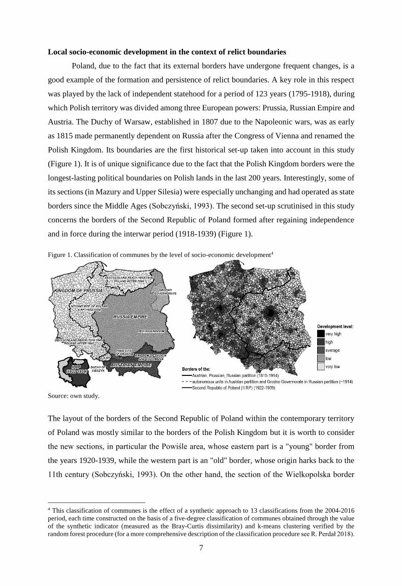
Local socio-economic development in the context of relict boundaries
Poland, due to the fact that its external borders have undergone frequent changes, is a
good example of the formation and persistence of relict boundaries. A key role in this respect
was played by the lack of independent statehood for a period of 123 years (1795-1918), during
which Polish territory was divided among three European powers: Prussia, Russian Empire and
Austria. The Duchy of Warsaw, established in 1807 due to the Napoleonic wars, was as early
as 1815 made permanently dependent on Russia after the Congress of Vienna and renamed the
Polish Kingdom. Its boundaries are the first historical set-up taken into account in this study
(Figure 1). It is of unique significance due to the fact that the Polish Kingdom borders were the
longest-lasting political boundaries on Polish lands in the last 200 years. Interestingly, some of
its sections (in Mazury and Upper Silesia) were especially unchanging and had operated as state
borders since the Middle Ages (Sobczyński, 1993). The second set-up scrutinised in this study
concerns the borders of the Second Republic of Poland formed after regaining independence
and in force during the interwar period (1918-1939) (Figure 1).
Figure 1. Classification of communes by the level of socio-economic development4
Source: own study.
The layout of the borders of the Second Republic of Poland within the contemporary territory
of Poland was mostly similar to the borders of the Polish Kingdom but it is worth to consider
the new sections, in particular the Powiśle area, whose eastern part is a "young" border from
the years 1920-1939, while the western part is an "old" border, whose origin harks back to the
11th century (Sobczyński, 1993). On the other hand, the section of the Wielkopolska border
4 This classification of communes is the effect of a synthetic approach to 13 classifications from the 2004-2016
period, each time constructed on the basis of a five-degree classification of communes obtained through the value
of the synthetic indicator (measured as the Bray-Curtis dissimilarity) and k-means clustering verified by the
random forest procedure (for a more comprehensive description of the classification procedure see R. Perdał 2018).

8
and the southern part of the Upper Silesian section functioned as a political border only in the
interwar period, hence it can be assumed that their layout to a lesser extent determines the social
and economic phenomena than in the case of the more permanent borders from the time of the
partitions of Poland.
The level of social and economic development of communes located in particular parts
of the country, functioning until 1918 in various political, cultural and socio-economic systems,
is evident in contemporary differences in social and economic development (Figure 1). The
number of communes with a high level of development in the former Prussia-annexed territories
is nearly twice as high as in the other partitions. In turn, the number of communes with a low
development level is lower than in the territories of the Austrian partition only by close to 11
pp and lower than the Russian partition by 22 pp. Within the borders of the former Prussia-
annexed territories, 34% of communes showed an average developed level; in the former
Austria-annexed territories the figure stood at 28%, and in the Russian partition nearly 16%.
The differences may stem from over one hundred years of operation of individual communes
in different political and economic systems. Importantly, the time of partitions coincided with
the first industrial revolution in Europe and with the dynamic growth of new sectors of the
economy. The area partitioned between the three superpowers was greatly diversified as to the
level of urbanisation and infrastructure development. In the Prussian partition, in 1910, 35% of
the population lived in towns and the density of railway lines in 1914 was 11.2 km/100 km2
(Jelonek, 1967, Taylor, 2007). At the same time, only 20% of people in the Austrian partition
lived in towns and the density of railway lines was 5.6 km/100 km2. In the Russia-annexed
territories, the respective figures were 22% and a mere 3.6 km/100 km2. The social and, above
all, economic policy of the partitioning states towards Polish territories was very diverse. The
Prussian authorities invested in transportation links between towns and the largest centres
(including administrative centres). As a result, almost every city in the Prussian partition had
access to railways. On the other hand, the Russian and Austrian authorities set up only the main
lines connecting the largest urban centres, which often bypassed other large centres (e.g.
Warsaw-Vienna Railway, Warsaw-Petersburg Railway, the Transversal Galicia Railway)
(Taylor, 2007). In the Prussian partition, most of the present-day capitals of regions played
major administrative roles. In 1910, Wrocław (512,000, the second largest city of the Kingdom
of Prussia and the fifth largest of the German Empire), Szczecin (235,000), Gdańsk (170,000)
and Poznań (157,000) were both capitals of provinces (regional units with self-government and
provincial assembly) and of regencies (sub-regional unit). Regency capitals included
Bydgoszcz (58,000), Olsztyn (33,000) and Opole (34,000), while Gorzów Wlkp. (39,000),
Katowice (43,000), Toruń (46,000), and Zielona Góra (23,000) – were capitals of poviats. In

9
the Austrian partition, only Krakow played a major role. With close to 150,000 inhabitants, the
city of the Austro-Hungarian Empire enjoyed a relatively high autonomy (initially Free City of
Krakow, and later the Grand Duchy of Krakow). In turn, Rzeszów (24,000) was only the capital
of Plzno circuit (an equivalent of a poviat). In the territories formerly annexed by Russia, most
of the urban centres were neglected. In 1910, in the Polish Kingdom capitals of governorates
(regional units with zero autonomy as to socio-economic matters) were Warsaw (895,000),
Lublin (65,000) and Kielce (32,000), while the dynamically developing Łódź, with 424,000
inhabitants, was merely a poviat capital in Piotrków Governorate. In turn, Białystok (80,000)
was outside the borders of the Polish Kingdom yet within the borders of the Russian Empire,
in Grodno Governorate. In the 1815-1914 period, in the Russian partition (only within the
present-day borders of Poland) slightly over 400 towns lost their city rights. At that time, in the
Austrian partition only 1 town lost city rights and in the Prussian partition – 34 towns.
The partition layouts are responsible for evident differences in the population of
communes, as witnessed by the structures of communes according to the level of social and
economic development in the three partitions. This was confirmed by the Pearson test of
significant differences, 𝜒2 𝑃𝑒𝑎𝑟𝑠𝑜𝑛, for RC tables (p = 0.0000). This demonstrates that there
is a correlation between the level of the social and economic development of communes and
their historical background.
Apart from the current level of the social and economic development, the territories
within the borders of the former partitions differ today also in the functional structure of
territorial units5 (independent of administrative status). In the territories formerly annexed by
Prussia, relative to the other partitions, there is the biggest number of urban communes (58%),
urban-rural communes (50%) and rural-urban ones (56%). Furthermore, in the former Prussian
partition the participation of rural communes is relatively the lowest (47%) in the structure of
this area, while e.g. in the former Russian partition the participation of such communes is the
highest – close to 74%.
Spatial diversity of political preferences
Current analyses of the diversity of political preferences in Poland on a regional and
local scale indicate very significant and persistent disproportions in electoral decisions
(Zarycki, 2015; Kowalski, 2016; Grabowski, 2018). In Poland, the time of the partitions is seen
as the period having the biggest impact on the durability of spatial diversity of political
5 Analysis of functional types identified communes with dominant features: urban, urban-rural, rural-urban, and
rural. The classification of these communes took into account variables concerning, among others, the structure of
population by age and employment sectors, the structure of land use, the structure of use of buildings and their
equipment with municipal facilities, the structure of enterprises and agricultural households (see GUS 2015).

10
preferences. It is assumed that this is the result of divergent levels of economic development of
the partitioning powers, which influenced the differences in the level of development of the
then Polish lands. In addition, the different social and cultural patterns and ideological
orientations in the particular partitions as well as the policy of the partitioning superpowers
towards the Polish population influenced the process of formation of these patterns (Raciborski,
1997). Analysis of the results of elections held in Poland since 1989 indicates the persistence
of relict boundaries as to political preferences (Grabowski, 2018). This means that the structure
of electoral support in neighbouring municipalities does not differ significantly from each other
provided the administrative units concerned lie within the same former partition. There are
marked differences between neighbouring administrative units located within areas which
formerly belonged to different partitions. Studies show that, in a generalised perspective, the
inhabitants of the former Prussian partition are more willing to support liberal parties (left-wing,
modern), while the inhabitants of the former Russian or Austrian partitions tend to vote for
conservative, right-wing parties (Matykowski, 2007; Zarycki, 2015).
This can be explained, among others, by historical differences in the structure of farms,
socio-economic development level and characteristics of the inhabitants. In the 19th century,
farms located in the areas of the former Prussian partition were more innovative and richer,
which gave rise to a surplus of agricultural production and contributed to a faster development
of cities in present-day Western Poland. According to J. Bartkowski (2007), economic
development and improvement of the material situation of the inhabitants of the partition was
a way of cultivating the Polish national spirit, which resulted from the higher effectiveness of
Polish enterprises, which had to compete with German ones. This led to the emergence of the
so-called middle class in the Prussian partition on a larger scale than in the other partitions, and
to this day the inhabitants of this part of Poland generally vote for parties supporting the creation
of good conditions for the emergence of the middle class, i.e. liberal parties willing to introduce
innovation. A similar trend applies to so-called regained territories, settled after World War II
by displaced people with a relatively low level of conservatism, a lower level of national
identification, but with a higher level of innovation, mobility and openness. These features are
responsible for the fact that the inhabitants of Western Poland vote more often for liberal and
left-wing parties. In turn, in the territories of the former Russian and Austrian partitions,
especially in rural areas with the tradition of private ownership in agriculture, whose inhabitants
show a relatively high level of conservatism, religious belief and national identity, there is a
persistently high support of conservative and right-wing parties (Bański et al., 2009).
Interestingly, different political preferences, related to a higher level of support for
liberal parties, can be observed in the strongly urbanised (i.e. with a higher level of
11
development) areas of the former Russian and Austrian partitions and in the autonomous units
of those partitions. Within the Russian partition, this applies to the following: Warsaw and Łódź
agglomerations and Grodno Governorate, until today inhabited by the Belorussian minority,
Orthodox and Muslim descendants of Polish Tatars (Janicki 2000; Węcławowicz 2018). In the
Austrian partition these are: Free City of Krakow and the Duchy of Cieszyn (as well as
Bieszczady Mountains, with a high percentage of migrant population from different Polish
regions which was a consequence of the Operation “Vistula”)6.
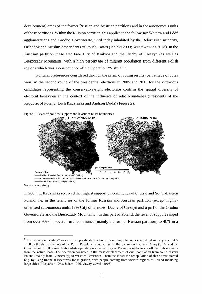
Political preferences considered through the prism of voting results (percentage of votes
won) in the second round of the presidential elections in 2005 and 2015 for the victorious
candidates representing the conservative-right electorate confirm the spatial diversity of
electoral behaviour in the context of the influence of relic boundaries (Presidents of the
Republic of Poland: Lech Kaczyński and Andrzej Duda) (Figure 2).
Figure 2. Level of political support and layout of relict boundaries
Source: own study.
In 2005, L. Kaczyński received the highest support on communes of Central and South-Eastern
Poland, i.e. in the territories of the former Russian and Austrian partition (except highly-
urbanised autonomous units: Free City of Krakow, Duchy of Cieszyn and a part of the Grodno
Governorate and the Bieszczady Mountains). In this part of Poland, the level of support ranged
from over 90% in several rural communes (mainly the former Russian partition) to 40% in a
6 The operation “Vistula” was a forced pacification action of a military character carried out in the years 1947-
1950 by the state structures of the Polish People’s Republic against the Ukrainian Insurgent Army (UPA) and the
Organisation of Ukrainian Nationalists operating on the territory of Poland in order to cut off the fighting units
from the natural base. The operation consisted in the mass displacement of civil population from south-eastern
Poland (mainly from Bieszczady) to Western Territories. From the 1960s the repopulation of these areas started
(e.g. by using financial incentives for migration) with people coming from various regions of Poland including
large cities (Maryański 1963, Jadam 1976, Gawryszewski 2005).

12
few urban or urban-rural communes of both partitions. The same spatial distribution of support
for the candidate of the right-wing electorate, although with lower shares, was recorded in 2015.
The percentage of votes obtained by A. Duda ranged from over 90% in five communes of the
former Russian partition to a mere 24.6% in the rural commune of Puńsk from the same
partition, but with an over 70% of Lithuanian minority.
Spatial interdependencies
An attempt to explain the relations between membership in specific historical systems
(i.e. the position of relict boundaries) and spatial distribution of the social and economic
development level and functional structure of communes and spatial differentiation of election
preferences, presented in the introduction, was carried out by means of regression models, in
particular spatial models of regression. The procedure of regression modelling of the above
relations took place in three stages. In the first stage, a simple and multiple regression method
was used, in which structural parameters of the model were estimated with the use of Ordinary
Least Squares (OLS) method. In the second stage, spatial regression models were used, in
particular the Spatial Lag Models (SLM) and Spatial Error Models (SEM) models (Anselin
1988, Rogerson 2001). In the third stage, local models of spatial regression were used in the
form of Geographically Weighted Regression (GWR) (Fotheringham et al. 2002).
The regression modelling procedure was preceded by the identification of the level of
correlation between dependent and independent variables (p < 0.0000)7. The level of support
for L. Kaczyński [KACZ] and A. Duda [DUDA] is: (1) negatively corelated with the position
of communes in the territories formerly annexed by Prussia (ca. -0.72 each) and positively
corelated with the position within the boundaries of the Second Republic (II RP; respectively,
0.60 and 0.55). In other words, a higher support of conservative and right-wing options can be
found in the communes which are not located in the former Prussia-annexed territories but were
within the boundaries of the Second Republic; (2) negatively corelated with the development
7 Dependent variables: support level during presidential election in the second round for (1) L. Kaczyński (2005)
and (2) A. Duda (2015). Independent variables: (1) persistence of historical layout: (a) binary values describing
location in particular partitions: 1 – location in a given partition, 0 – location in another partition [variables: AUST,
PRUS, ROSJ], (b) values 1-3 for communes located in partitions: 1 – Russian, 2 – Austrian, 3 –Prussian partition
(ordering scale representing the level of socio-economic development of partitions – urbanisation and
infrastructure levels) [variable: ZAB3], (c) binary values describing location in the Second Republic: 1 – location
within the borders of the Second Republic, 0 – location outside the borders of the Second Republic [variable:
IIRP], (2) socio-economic development level expressed by means of: (a) growth level class in 2005 and 2015: 1 –
very low, 2 – low, 3 – average, 4 – high, 5 – very high development level [variables: LL05 and LL15], (b) synthetic
approach (synthesis from 13 observations from 2004-2016): 1 – very low, 2 – low, 3 – average, 4 – high, 5 – very
high development level [variable: SYNT]; (3) commune type: (a) administrative type: 1 – rural commune, 2 –
urban-rural commune, 3 – urban commune [variable: TADM], (b) functional type: 1 – rural commune, 2 – rural-
urban commune, 3 – urban-rural commune, 4 – urban commune [variable: TFUN].
13
level measured by the class of growth level [LLxx] for 2005 and 2015 (respectively, -0.55 and
-0.43). The persistence of these interlinks is confirmed by the high negative correlation with
the synthetic indicator of growth (respectively, -0.56 and -0.47); (3) negatively corelated with
the administrative type of communes [TADM] and with the functional type [TFUN], i.e. a
higher support of conservative and right-wing options can be found in rural and rural-urban
communes, while a lower support in urban and urban-rural communes.
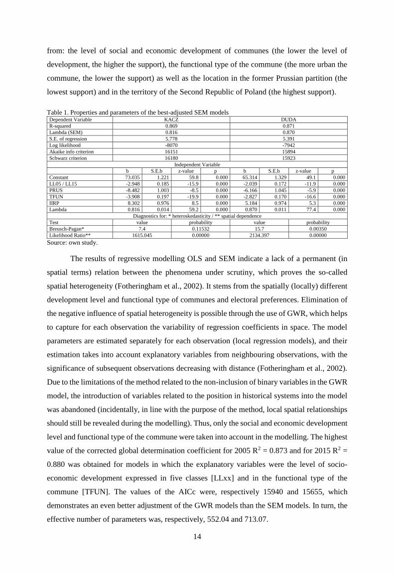
From among the tested OLS models for the 2005 data8 representing various
combinations explanatory variables, the best model9 was the one which accounted for the
degree of support for L. Kaczyński [KACZ] via the level of socio-economic development, as
described by the class of growth level in 2005 [LL05], functional type of the commune [TFUN]
and location in the area of the former Prussian partition [PRUS]. The values of the corrected
coefficient were, respectively, 0.673 and 0.620, and therefore we can suspect that most of the
changeability of support for both candidates is explained by the variables used. Spatial
dependencies testing indicates that some variables that may be spatially correlated are not
included in the model. This is confirmed by the high value of the global I-Moran’s statistics
(respectively 0.570 and 0.645) expressing the level of spatial autocorrelation of residuals from
regression models. It should be emphasized that the presence of residual autocorrelation
negatively affects the accuracy of OLS estimators determination. Diagnostic tests investigating
the level of spatial dependence show that there is both spatial autocorrelation of the random
component, which suggests the use of SEM, and spatial autoregression, which indicates the
potential use of SAR, in particular SLM. For both of the studied states as a result of modelling
it turned out that SEM models with explanatory variables describing the level of socio-
economic development [LLxx], location on the lands of the former Prussian partition [PRUS]
and within the borders of the Second Republic [IIRP] and the functional type [TFUN]
demonstrate the best information criteria (Table 1). Both models are characterized by high
values of the determination coefficient, which indicates that the variables in the models explain
almost 87% of the variability of the support value. The SEM model of support for A. Duda is
characterized by a lower value of the AIC and Schwarz criteria. In both OLS models, the
influence of residual autocorrelation was eliminated by estimating the SEM model. The SEM
models obtained are characterized by significantly lower values of information criteria in
relation to OLS models, which proves that SEM models are better suited to empirical data. This
confirms the assumption that the level of support for L. Kaczyński and A. Duda stems primarily
8 The relatively high convergence of the results of both candidates and the level of correlation with the explanatory
variables led to the assumption that the testing of different types and variants of regression models will be carried
out only for the 2005 data, and then the best variants will be repeated for 2015. 9 I.e. with the lowest values of the Akaike and Schwarz criteria and the highest log likelihood values.
14
from: the level of social and economic development of communes (the lower the level of
development, the higher the support), the functional type of the commune (the more urban the
commune, the lower the support) as well as the location in the former Prussian partition (the
lowest support) and in the territory of the Second Republic of Poland (the highest support).
Table 1. Properties and parameters of the best-adjusted SEM models Dependent Variable KACZ DUDA
R-squared 0.869 0.871
Lambda (SEM) 0.816 0.870
S.E. of regression 5.778 5.391
Log likelihood -8070 -7942
Akaike info criterion 16151 15894
Schwarz criterion 16180 15923
Independent Variable
b S.E.b z-value p b S.E.b z-value p
Constant 73.035 1.221 59.8 0.000 65.314 1.329 49.1 0.000
LL05 / LL15 -2.948 0.185 -15.9 0.000 -2.039 0.172 -11.9 0.000
PRUS -8.482 1.003 -8.5 0.000 -6.166 1.045 -5.9 0.000
TFUN -3.908 0.197 -19.9 0.000 -2.827 0.170 -16.6 0.000
IIRP 8.302 0.976 8.5 0.000 5.184 0.974 5.3 0.000
Lambda 0.816 0.014 59.2 0.000 0.870 0.011 77.4 0.000
Diagnostics for: * heteroskedasticity / ** spatial dependence
Test value probability value probability
Breusch-Pagan* 7.4 0.11532 15.7 0.00350
Likelihood Ratio** 1615.045 0.00000 2134.397 0.00000
Source: own study.
The results of regressive modelling OLS and SEM indicate a lack of a permanent (in
spatial terms) relation between the phenomena under scrutiny, which proves the so-called
spatial heterogeneity (Fotheringham et al., 2002). It stems from the spatially (locally) different
development level and functional type of communes and electoral preferences. Elimination of
the negative influence of spatial heterogeneity is possible through the use of GWR, which helps
to capture for each observation the variability of regression coefficients in space. The model
parameters are estimated separately for each observation (local regression models), and their
estimation takes into account explanatory variables from neighbouring observations, with the
significance of subsequent observations decreasing with distance (Fotheringham et al., 2002).
Due to the limitations of the method related to the non-inclusion of binary variables in the GWR
model, the introduction of variables related to the position in historical systems into the model
was abandoned (incidentally, in line with the purpose of the method, local spatial relationships
should still be revealed during the modelling). Thus, only the social and economic development
level and functional type of the commune were taken into account in the modelling. The highest
value of the corrected global determination coefficient for 2005 R2 = 0.873 and for 2015 R2 =
0.880 was obtained for models in which the explanatory variables were the level of socio-
economic development expressed in five classes [LLxx] and in the functional type of the
commune [TFUN]. The values of the AICc were, respectively 15940 and 15655, which
demonstrates an even better adjustment of the GWR models than the SEM models. In turn, the
effective number of parameters was, respectively, 552.04 and 713.07.
15
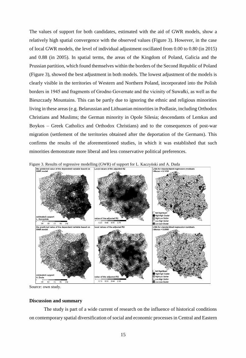
The values of support for both candidates, estimated with the aid of GWR models, show a
relatively high spatial convergence with the observed values (Figure 3). However, in the case
of local GWR models, the level of individual adjustment oscillated from 0.00 to 0.80 (in 2015)
and 0.88 (in 2005). In spatial terms, the areas of the Kingdom of Poland, Galicia and the
Prussian partition, which found themselves within the borders of the Second Republic of Poland
(Figure 3), showed the best adjustment in both models. The lowest adjustment of the models is
clearly visible in the territories of Western and Northern Poland, incorporated into the Polish
borders in 1945 and fragments of Grodno Governate and the vicinity of Suwałki, as well as the
Bieszczady Mountains. This can be partly due to ignoring the ethnic and religious minorities
living in these areas (e.g. Belarussian and Lithuanian minorities in Podlasie, including Orthodox
Christians and Muslims; the German minority in Opole Silesia; descendants of Lemkas and
Boykos – Greek Catholics and Orthodox Christians) and to the consequences of post-war
migration (settlement of the territories obtained after the deportation of the Germans). This
confirms the results of the aforementioned studies, in which it was established that such
minorities demonstrate more liberal and less conservative political preferences.
Figure 3. Results of regressive modelling (GWR) of support for L. Kaczyński and A. Duda
Source: own study.
Discussion and summary
The study is part of a wide current of research on the influence of historical conditions
on contemporary spatial diversification of social and economic processes in Central and Eastern

16
Europe, marking the influence of relict and phantom boundaries on the scope and spatial
regularities of identified regularities.
The methodology adopted in the study broadens in a fundamental way the earlier
analytical approaches and contributes to methodological progress in the relevant research
carried out within Geographical Sciences. It indicates the usefulness of regression modelling,
including the importance of GWR models for objective, statistical identification and
interpretation of spatial relationships.
It has been proved that Poland is undoubtedly one of the most important testing grounds
for studying the impact of historical determinants on the contemporary differentiation of
development processes. This is due to the fact that it is an area particularly experienced by
historical events, which have caused deep-seated and long-lasting changes in the layout of
political boundaries.
The research findings confirm the existence of strong and statistically significant
relations between the size and spatial structure of political preferences and spatial diversity of
the level of social and economic growth in systems directly related to the course of relict borders
in the area of today's Poland. In line with the assumptions of R. Hartshorn (1933), these borders
are antecedent borders, i.e. they no longer have a political function, but are evident in the
cultural diversity in economic, social and spatial terms (Prescott, Triggs, 2008) (e.g. western
borders of the Polish Kingdom, simultaneously constituting the borders between the former
Prussian and Russian partitions). The layout of the borders confirms the existence of phantom
borders, i.e. virtual borders which come to the fore in the spatial diversity of the social and
economic phenomena analysed, but which do not always correspond to the present and past
territorial divisions (e.g. the present, eastern borderland of Poland affected by repatriation
movements after 1945). The results confirm the regularities underlined by L. O'Dowd and T.
Wilson (2002), drawing attention to the fact that in times of advancing economic integration,
which weakens the importance of political borders, an increase in the importance of their relict
counterparts can be observed. It is these relict boundaries that significantly and permanently
impact the spatial diversity of developmental factors.
As a result of the application of GWR models, the incidence of relict boundaries was
confirmed, especially between the liberal and progressive lands of the former Prussian partition
and large urban agglomerations in the remaining partitions on the one hand, and the
conservative-right part of the country within the Russian and Austrian partition on the other
(Zarycki 2015). This is a result of differentiated urbanisation and infrastructural conditions,
which form the material and functional basis for social and economic growth, as well as of
divergent socio-cultural patterns established in relatively mobile communities of Western
17
Poland (due to the settlement of the regained territories) and less mobile communities of Eastern
Poland (indigenous, with a high share of private property in agriculture). The GWR results
confirm with high probability that the presence of local communities, e.g. national and religious
minorities (the aforementioned Belarussian and Lithuanian minorities in Podlasie and
Suwalszczyzna, or the German minority in Opole Silesia) may influence the local weakening
of the explanatory power of the regression model. This is confirmed by the observations of J.
Bański et al. (2009, p. 503), who claimed that the electoral behaviour of certain social groups
in spatial terms may make it difficult to unambiguously assess the influence of particular factors
(including historical and cultural ones) on political preferences.
The results confirm the incidence of strong correlations between the spatial diversity of
the level of growth and the structure of political preferences, characterised by dangerous
tendencies. They are related to the radicalization of the inhabitants of the economically weakest
areas and their increased susceptibility to populist suggestions of conservative political groups,
which is reflected in their electoral preferences. This takes the form of a symbolic opposition
to the current situation, which Rodríguez-Pose (2017) calls a revenge of “places that don’t have
a future” and which do not want to remain “places that don’t matter.” Residents of these areas
expect the effective cohesion policy intervention. At present, the place-based policy is
becoming more and more popular and its practice seems to be suitable for tearing these areas
out of the "vicious circle" of marginalisation in which they fell as a consequence of applying
the "one size fits all" approach. The adaptation of the nature and scope of interventions to local
resources, needs and challenges, while taking full advantage of the subsidiarity principle, may
bring the expected results. It can turn on these areas back into a network of socio-economic
relations that provide sustainable growth and development (McCann, Varga, 2018).
BIBLIOGRAPHY
Anselin L., 1988. Spatial Econometrics: Methods and Models, Kluwer Academic Publishers, Dordrecht.
Bachmann V., Sidaway J. D., 2016. “Brexit geopolitics.” In: Geoforum, 77, 47–50.
Bański J., Kowalski M., Mazur M. 2009. “Zachowania wyborcze mieszkańców polskiej wsi.” Przegląd
Geograficzny 81: 483–506.
Bartkowski J., 2003. Tradycja i polityka. Wpływ tradycji kulturowych polskich regionów na współczesne
zachowania społeczne i polityczne. Wydawnictwo Akademickie “Żak”, Warszawa.
Biondich M., 2011. The Balkans – Revolution, War, and Political Violence since 1878. Oxford University Press,
Oxford.
Boas, T. C., 2007. “Conceptualizing continuity and change. The composite-standard model of path dependence.”
Journal of Theoretical Politics 19, 33–54.
Campbell, A., Converse, P. E., Miller, W. E., Stokes, D. E., 1966. Elections and the Political Order. New York:
John Wiley.
Cox, K. R. 1968. “Suburbia and Voting Behaviour in the London Metropolitan Area.” Annals of the Association
of American Geographers 58: 111–127.
Cox, K. R. 1969. “The Voting Decision in a Spatial Context.” Progress in Geography 1: 81–117.
18
Eyal, G.; Szelényi, I. and Townsley, E. R., 1998. Making capitalism without capitalists. Class formation and elite
struggles in post-communist Central Europe. London, New York.
Fotheringham A.S., Brunsdon C., Charlton M., 2002. Geographically Weighted Regression. The Analysis of
Spatially Varying Relationships, John Wiley & Sons, Chichester.
Fratesi, U. and Rodríguez-Pose, A. 2016. “The crisis and regional employment in Europe: what role for sheltered
economies?” In: Cambridge Journal of Regions, Economy and Society, 9(1): 33–57.
Gawryszewski A., 2005. Ludność Polski w XX wieku, IGiPZ PAN, Warszawa.
Gherghina, S., Jiglău, G., 2011. “Explaining ethnic mobilisation in post-communist countries.” Europe-Asia Stud-
ies 63 (1), 49–76.
Gorzelak G., Jałowiecki B, 1998. “Koniunktura gospodarcza i mobilizacja społeczna w gminach w latach 1995-
1998”. In: Gorzelak G., Jałowiecki B. (ed.), Koniunktura gospodarcza i mobilizacja społeczna w gminach,
ERRiL, Warszawa.
Grabowski W., 2018. “Determinanty przestrzennego zróżnicowania wyników głosowania w wyborach
parlamentarnych z 2015 roku”. Studia Socjologiczne, 1 (228), 35–64.
Gros, D. 2016. Is globalisation really fuelling populism? Brussels: Centre for European Policy Studies.
GUS, 2015. Badanie statystyczne w zakresie identyfikacji obszarów gmin (rejonów statystycznych) o cechach
miejskich, miejsko-wiejskich, wiejsko-miejskich i cechach wiejskich, w poszczególnych województwach
oraz wskaźnika syntetycznego różnicującego gminy na podstawie kryterium funkcjonalnego. Praca
badawcza, GUS, Warszawa.
Hartshorne R., 1933. “Geographic and Political Boundaries in Upper Silesia.” Annals of Association of American
Geographers, XXIII (4), 195–228.
Hirschhausen B. von, 2017. “The heuristic interest of the concept of ‘phantom borders’ in the understanding of
cultural regionalization.” L’Espace géographique 2017/2(46), 106–125.
Huntington S.P., 1998. Zderzenie cywilizacji i nowy kształt ładu światowego, Muza, Warszawa.
Jadam H., 1976, Pionierska społeczność w Bieszczadach, WSP, Rzeszów.
Janicki W., 2000. Tatarzy w Polsce - naród, grupa etniczna czy "ludzie pogranicza"? Czasopismo Geograficzne
71(2), 173-187.
Jańczak J., 2015. “Phantom borders and electoral behavior in Poland - historical legacies, political culture and
their influence on contemporary politics.” Erdkunde, 69(2), 125–137.
Jelonek A., 1967, Ludność miast i osiedli typu miejskiego na ziemiach polskich od 1810 do 1960 r. Dokumentacja
Geograficzna, z. 3-4, Instytut Geografii PAN, Warszawa.
Kolossov, V., 2005. “Theorizing borders. Border studies: changing perspectives and theoretical approaches.”
Geopolitics 10, 606–632.
Koneczny F., 1935. O wielkości cywilizacji, Gebethner i Wolf, Kraków.
Kosmala G., 2003. Granica reliktowa, Dom Wydawniczy Duet, Toruń.
Kowalski M., 2000. “Geografia wyborcza Polski. Przestrzenne zróżnicowanie zachowań wyborczych Polaków w
latach 1989-1998.” Geopolitical Studies, vol. 7.
Kowalski M., 2016. Trwałość geograficzna wyników wyborów w Polsce. IGiPZ PAN, Warszawa.
Kraft, C., 2015. “Phantomgrenzen und Zeitschichten im Postsozialismus. Ist der Postsozialismus postkolonial.”
In: Hirschhausen, B.v., Grandits, H., Kraft, C., Müller, D., Serrier, T. (eds.), Phantomgrenzen. Räume Und
Akteure in Der Zeit Neu Denken. Wallstein Verlag, Göttingen, 166–190.
Geographers 49, 269–285.
Kürti L., 2001. The Remote Borderland - Transylvania in the Hungarian Imagination. State University of New
York Press, New York.
Löwis S. von, 2017. “Phantom borders and ambivalent spaces of identification in Ukraine.” L’Espace
géographique, 2017/2(46), 126–142.
Lukowski, J., 1999. The Partitions of Poland 1772, 1793, 1795, Routledge, London.
McCann P., Varga A., (ed.) 2018, Place-based Economic Development and the New EU Cohesion Policy. Region
and Cities, 1st Edition, Routledge
Magocsi P.R., 2010. A History of Ukraine. The Land and its Peoples. Toronto: University of Toronto Press.
Maryański A., 1963, Współczesne migracje ludności w południowej części pogranicza polsko -radzieckiego i ich
wpływ na rozmieszczenie sił wytwórczych tego obszaru, Wyższa Szkoła Pedagogiczna, Kraków.
Matykowski R., 2004. “Świadomość regionalna mieszkańców w kontekście społeczno-geograficznym i
kulturowym. Analiza wybranych obszarów Polski.” In: E. Orłowska (ed.), Kulturowy aspekt badań
geograficznych. Studia teoretyczne i regionalne, vol. IV, Wrocław, 71–84.

19
Matykowski R., 2009. Eks-granice i aktualne granice administracyjne a zachowania wyborcze Polaków na
początku XXI wieku w woj. śląskim i wielkopolskim, 87–95.
Matykowski, R., 2007. “Zachowania wyborcze Wielkopolan: Czy występują odmienności w przestrzeni
geograficzno-historycznej?”. In: (ed.), J. Schmidt, Granica. Wydawnictwo AWEL, Poznań, 75–92.
O’Dowd, L. and Wilson, T., 2002. “Frontiers of sovereignty in the new Europe.” In: Alkan, N. (ed.): Borders of
Europe. Bonn, 7–30.
Perdał R., 2018. Zastosowanie analizy skupień i lasów losowych w klasyfikacji gmin w Polsce na skali poziomu
rozwoju społeczno-gospodarczego. Metody Ilościowe w Badaniach Ekonomicznych, XIX/3, 263-273.
Peters, B. G; Pierre, J. and King, D. S., 2005. “The politics of path dependency: political conflict in historical
institutionalism.” The Journal of Politics 67, 1275–1300.
Piskozub A., Kozłowski A. R., Knoch M., 2009. “Zmarnowana szansa wyzwolenia całego terytorium dawnej
Rzeczypospolitej u schyłku pierwszej wojny światowej.” Przegląd Geopolityczny, year 1, 133–160.
Prescott J.R.V., 1965. The geography of frontiers and boundaries, Chicago.
Prescott V., Triggs G.D., 2008. International Frontiers and Boundaries. Martinus Nijhoff Publishers, Leiden –
Boston.
Putrenko, V., 2013. “Spatial relationship of electoral behaviour and phantom borders in Ukraine.” A paper
presented at the conference “Phantom Borders in the Political Behaviour and Electoral Geography in East
Central Europe”, Frankfurt (Oder)/Słubice, November 14–15, 2013.
Raciborski J., 1997. Polskie wybory. Wydawnictwo Naukowe Scholar, Warszawa.
Rodríguez-Pose A., 2017. “The revenge of the places that don’t matter (and what to do about it).” Cambridge
Journal of Regions, Economy and Society, 11 (1), 189–209.
Rodríguez-Pose A., Garcilazo E., 2015. “Quality of Government and the Returns of Investment: Examining the
Impact of Cohesion Expenditure in European Regions,” Regional Studies, vol. 49, no. 8: 1274–1290.
Rodrik, D. 2017. Populism and the economics of globalization. Working Paper 23559, National Bureau of
Economic Research. Cambridge, Ma.
Rogerson P. A., 2001. Statistical Methods for Geography, SAGE Publications, London.
Sobczyński M., 1984. “Niezmienność dawnych granic politycznych na obszarze Polski.” Acta Universitatis
Lodziensis. Folia Geographica, 3, 119–137.
Sobczyński M., 1993. “O potrzebie badania granic na gruncie polskiej geografii politycznej.” In: Współczesna
geografia polityczna. Contemporary Political Geography, Conference Papers, 17, IGiPZ PAN, Warszawa,
125–128.
Taylor Z., 2007. Rozwój i regres sieci kolejowej w Polsce. IGiPZ PAN, Warszawa.
Urbatsch R., 2017. “Long-term effects of ethnic cleansing in the former Polish-German borderlands.” Political
Geography, 58, 56–66.
Węcławowicz G., 2018. Geografia społeczna Polski, Wydawnictwo Naukowe PWN, Warszawa.
Zamfira, A., 2015, “Methodological limitations in studying the effect of (inter)ethnicity on voting behaviour, with
examples from Bulgaria, Romania and Slovakia.” Erdkunde 69(2), 161–173.
Zarycki T., 2015. “The electoral geography of Poland: between stable spatial structures and their changing
interpretations.” Erdkunde, 69(2), 107–124.